Jun Shen International Cooperation Center. China Satellite Navigation Office
|
|
|
- Phoebe McLaughlin
- 5 years ago
- Views:
Transcription
 International Cooperation")

 November 1-6,")
1 Jun Shen International Cooperation Center Tenth Meeting of the International Committee on Global Navigation Satellite Systems (ICG) November 1-6,
2 Introduction and Background 2
3 Unique BDS Features Unique BDS features include With BDS satellites, the users can track GNSS satellites in the BDS coverage area; BDS offers at least 3 different signals (B1, B2, and B3) which are compatible and interoperable with other GNSS systems; With the unique space segment architecture (with satellites in GEO, IGSO and MEO), BDS signals offer better elevation angles. Those features would provide significant improvement and enhancements for the system performance (for example, positioning accuracy, system reliability, convergence time, interference mitigation, etc.). 3
4 BDS Application Development 4
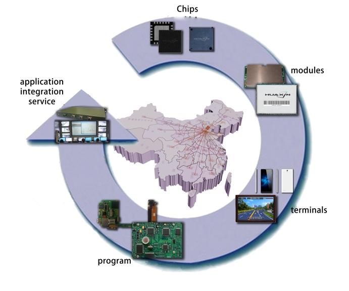
5 BDS Application Development: Project Architecture Policies and standards (Industrial policy, intellectual property rights, domestic and international standards) Fundamental products (ASIC chips, modules, antennas, simulators, and navigation software, etc.) Fundamental facilities (Ground-based argumentation systems, testing and certification systems) Application demonstration (at industrial, regional demonstration, and international level) Industrialization (BDS-based GNSS industrial chain) 5


6 Application Development and Popularization Comprehensively push forward the R&D and industrialization processes of BDS/GNSS fundamental products, such as chips, module, antennas, simulators, navigation software, etc. The sales volume of BDS/GNSS navigation chips and modules has surpassed 6 million The sales volume of high-precision surveying boards has surpassed 85, 000 sets, which counts for 1/3 of the domestic market share The sales volume of navigation antenna is approximately 3 million sets The sales volume of high-precision antenna is approximately 280, 000 pieces, which counts for 90% of the domestic market share 6


7 Application Development and Popularization Transportation 7

 10 5 0 0")

8 Application Development and Popularization Metrology 风速 ( 米 / 秒 ) 年 8 月 12 日 0 点时间 ( 小时 ) 8
9 Application Development and Popularization Metrology BDS-based Atmosphere, Ocean and Space Monitoring and Warning System Achieve technical breakthroughs for BDS applications on metrology. Construct BDS-based applications in the following areas: Meteorological sounding Water vapor ionosphere remote sensing and detection Ocean wave and wind detection Metrological early warning Develop a completed set of industrial standards. 9


10 Maritime Weather Observation BDS/GNSS Maritime Weather Observation System To build a BDS/GNSS system for: Monitoring the changes on ocean surface Reflecting the amount of water vapor in the air BDS/GPS Dual-mode Terminals


11 Yangjiang Experimental Demonstration Station Reflection geometry


12 Satellite Selection BDS GEO 04 Satellite: Providing a stable geometry High spatial resolution Good visible continuity Antenna footprint and reflection zone of GEO 04

13 Test Results 24 o N Latitude 22 o N 20 o N 18 o N 16 o N - 18:00-12:00 JEBI - 06:00 08/03/13-00:00 阳江站 - 12:00-06:00-18:00 08/14/13-00:00-12:00 UTOR - 06:00 08/13/13-00:00-18: o E 108 o E 111 o E 114 o E 117 o E 120 o E Longitude JEBI UTOR

14 Application Development and Popularization Fishery 14


15 Application Development and Popularization Guangdong Province 15


16 Application Development and Popularization Shanghai Architecture of Satellite navigation demonstration application project in Yangtze River Delta 16


17 Application Development and Popularization Implement projects in fields of disaster reduction, public security, maritime search and rescue, in Hunan, Shaanxi, Beijing and Guizhou Provinces. Initiate projects in fields of terrestrial resources, tourism, electric power, in Jiangsu, Xinjiang, Hubei, Yunnan provinces and Chengdu-Chongqing region. 17


18 Application Development and Popularization Smart phones Vehicle Navigation Huawei B199 Samsung Galaxy Note III 18


19 Promotion of Mass Market - Public Service Platform Terminal (Sensor) Surveying Terminal Monitoring Terminal IOT Terminal BDS Public Service Platform Application System Testing Services Public Development Environment APP platform Innovation Works Industry Data Integration Geospatial data National GPNT Infrastructure Navigation data Indoor and Outdoor Seamless Positioning Energy Saving and Emission Reduction BDS Terminal Test and System Assessment Goods Tracing Information System Special and Public Vehicle Information System Precision Agriculture Demonstrations Applications Modern Logistics Asset Management Terminal Precise positioning Timing 19 Personal Asset Management Services


20 Mass Market Applications Smart phones Wearable equipment Vehicle navigation BeiDou school bus 20

21 Application Development and Popularization National Differential BDS System (NDBDS) NDBDS will provide meter/decimeterlevel wide area navigation and positioning services as well as centimeterlevel real time regional positioning services for China and its neighboring areas. BeiDou Satellite-based Augmentation System (BDSBAS) In order to meet the demands of civil aviation users for CAT-I services, design for a dual-frequency multi-system augmentation system in line with international conventions is underway. 21


22 Application Development and Popularization The State Council published Several Advisory Opinions of the State Council on Promoting Information Consumption to Expand Domestic Demands and The Midand Long- Term National Development Plan for Satellite Navigation Industry. The Development and Reform Commission, the Ministry of Agriculture and the National Administration of Surveying, Mapping and Geoinformation have issued policy recommendations. The National Technical Committee on BeiDou Satellite Navigation of Standardization Administration of China has been established. 22
23 Application Development and Popularization On June 14, 2015, State Council released Promoting Platform for National Integrated Circuit Industry Development Coped with the implementation of state key science and technology implementation, breakthrough on some critical integrated circuits and innovative mechanism for promoting cooperative work and business model will be achieved Gradually develop the IC applications and embedded software in the fields of smart card, intelligent power network, intelligent transportation, satellite navigation, industrial control, financial electronics, automobile electronics, medical electronics. Jointly developed by State Development and Reform Commission, MIIT, MOST, etc, The Policy on the Promotion of the BeiDou Satellite Navigation Industry Development (Draft) is in the final review process. 23
24 Application Development and Popularization Design and Implementation of State BDS Satellite Navigation Standard Architecture Include 571 standards Organized in a leveled structure of fundamental, system construction, system operation, and applications An open system architecture for further expansion Eight standards have been submitted for national standard approval and twenty BDS project standards will be released soon. Support and promote BDS to be included in the international standard systems such as ICAO, IMO, 3GPP, etc. 24
25 BDS Application Development for International Markets 25
26 Application Areas for the Asia-Pacific Market The following five pivotal BDS application areas have been identified for the Asia-Pacific market: a) High-precision positioning b) Mass market c) Tourism and intelligent transportation d) Disaster prevention and relief e) Maritime applications 26


 Precision Agriculture BDS CORS")

27 Application Areas for the Asia-Pacific Market Dual-frequency applications and establishment of augmentation systems Forrest Pest Control BeiDou CORS Application in Pakistan (Courtesy of BDNST) Precision Agriculture BDS CORS Application in Laos (Courtesy of ComNav) BeiDou CORS Application in Thailand (Courtesy of Optics Valley BeiDou )


28 Pakistan National Positioning Service Network Project Phase I (Source: UniStrong/BDNST) 28


29 Pakistan National Positioning Service Network Project Phase I (Source: UniStrong/BDNST) 29
 -")

30 Pakistan National Positioning Service Network Project (Phase I) - RTK Test Results RTK fixed solution 93KM outside of the network coverage 30

 (exclude internet unavailability, Usability Navigation power supply, ionospheric scintillation) 99.0% ( in one day) Position 95.0% (in 365 days),99.")
31 Pakistan National Positioning Service Network Project Phase I (Source: UniStrong/BDNST) Items Content Technical Specification Scope Navigation Within and extendable to 100KM away from coverage area Position Within and extendable to 30KM away from valid coverage area Navigation Navigation, GIS information collection and update Service Mapping & Surveying, cadastral inventory, urban Position planning, construction, deformation monitoring System Real-time Horizontal 2cm Vertical 5cm Accuracy Postprocessing Horizontal 3mm Vertical 10mm 1σ normal condition Navigation Horizontal 2m Vertical 3m Latency Real time <500ms 95.0% (in 365 days) (exclude internet unavailability, Usability Navigation power supply, ionospheric scintillation) 99.0% ( in one day) Position 95.0% (in 365 days),99.0% (in one day) Completeness Warning <6 seconds time Compatibility Navigation & Position It is able to generate international RINEX data and compatible with standard differential format RTCM, so it s compatible with all kinds of post processing software and third party receivers( GPS and GLONASS only) Note: Above accuracy index is based on WGS-84 coordinate system 31


32 BDS/GNSS Applications on Surveying and Measurements Precise Railway Track Measurement & Adjustment Bridge Deformation Monitoring Hydro-dam Monitoring

33 BDS Applications on Precision Agriculture (Courtesy of BDNST)


34 Demonstration of the Traffic Information Service in Bangkok, Thailand In March, 2011, the PND and the Internet version of the Bangkok traffic information service demonstration was made at the 32nd Bangkok Motor Show In July, 2012, the Thailand automobiles have adopted the traffic information services 34

35 Demonstration of the Traffic Information Service in Bangkok, Thailand Currently, the data sources are the onboard GPS terminals and some BDS terminals of nearly 10 thousand taxies. With more BDS terminals being installed, integrated BDS data will be provided for better services to the Thailand customers. Red means almost in a stop. Yellow means low velocity.. Green means high velocity. 35

36 Disaster Prediction and Mitigation System 3S (GNSS&RS&GIS) + Communications Integrated To obtain disaster prediction and relief information quickly Covering various business models to form a completed system RS GNSS Where Anywhere Disaster Reduction System When Anytime GIS What Anything Communication 36

37 Digital Disaster Reduction Terminal Digital disaster mitigation terminal is designed for collecting Information when a disaster happens. In combination with GPRS/CDMA2000, BeiDou/GPS, it can be used for disaster reduction tasks, such as navigation, disaster information collecting, disaster information transmitting by satellite communications or mobile communications. An international project has been undertaken by China, Pakistan, Thailand, Iran, and Bangladesh under the APSCO framework. Digital Disaster Reduction Terminal


38 BDS Maritime Applications Offshore Operation Marine fishery Marine transportation Oceanographic engineering Rescue Maritime Electronic Customs Clearance Customs Frontier inspection Quarantine Maritime affairs Port Operation Container Operation machinery Freighter Maritime Meteorological Observation Sea surface observation Typhoon observation 38
39 Summary The unique BDS features directly support reliable, high-quality GNSS applications, including earth observation applications With the careful planning, the BDS/GNSS application development efforts have been proceeding smoothly; BDSbased products have been gaining market shares in various application areas Pivotal applications for international markets have been identified and developed The BDS/GNSS applications have been growing very rapidly; the results from early adopters are very promising the results are comparable with those from other GNSS systems, and are superior in some application environments 39
40 Dr. Jun Shen Deputy Director, International Cooperation Center 40
International Cooperation Research Center, China Satellite Navigation Office
 International Cooperation Research Center, ICG-8, Nov 10, 2013 Dubai Overview BeiDou Navigation Satellite System (hereinafter referred to as BDS") has provide regional service by the end of 2012, which
Operation and Development of BeiDou Navigation Satellite System
 Operation and Development of BeiDou Navigation Satellite System Jing Li IAIN 2015, 20 23 October Prague, Czech Republic 2 01 03 Plan and Policy 02 Status and Near-term Goal International Cooperation 3
Development of BeiDou Navigation Satellite System
 Development of BeiDou Navigation Satellite System May 18 2015 Krasnoyarsk, Russian Federation Contents 1 2 3 4 5 System Overview System Application International Cooperation Recent Plan Summary Contents
Update of BeiDou Navigation Satellite System
 Update of BeiDou Navigation Satellite System 01 03 Development Plan 02 Latest Progress Recent Plans 01 03 Development Plan 02 Development Objectives Basic Principles Development Steps Latest Progress System
China Satellite Navigation Office
 01 03 Development Plan 02 Latest Progress Recent Plan 01 03 Development Plan 02 Development Objectives Basic Principles Development Steps Latest Progress System Components Fundamental Policies Recent Plan
Development of BeiDou Navigation Satellite System
 The 8 th Meeting of the International Committee on GNSS Development of BeiDou Navigation Satellite System China Satellite Navigation Office Dubai, UAE November, 2013 Contents Contents 1. Objectives and
China Satellite Navigation Office
 MA Changdou Kathmandu, Nepal 12December 2016 01 Policy of Development 02 Latest Progress 03 Recent Plan The whitepaper on BDS has been released in June 2016, to interpret its development concepts and propositions.
BeiDou: Bring the World and China to Your Doorstep
 IGS Workshop 2012-ICG Working Group A BeiDou: Bring the World and China to Your Doorstep China Satellite Navigation Office 2012.7.25 Olsztyn, Poland 1 Contents I. Development Schemes II. Performance III.
Update on BeiDou Navigation Satellite System
 Update on BeiDou Navigation Satellite System 1 BDS Development 2 Near-term Plans BD-2 System FOC services from December, 2012 (5GEO+5IGSO+4MEO) Two on-orbit backup satellites launched in 2016 (1 IGSO+1
Status of COMPASS/BeiDou Development
 Status of COMPASS/BeiDou Development Stanford s 2009 PNT Challenges and Opportunities Symposium October 21-22,2009 Cao Chong China Technical Application Association for GPS Contents 1. Basic Principles
High Precision Applications with BeiDou
 High Precision Applications with BeiDou Lei HUANG Unicore Communications, Inc May 14, 2013 Contents 1 2 3 4 Background Overview of BeiDou high precision products Applications of BeiDou high precision products
Nigerian Communications Satellite Ltd. (NIGCOMSAT)
") OVERVIEW OF NIGERIAN SATELLITE AUGMENTATION SYSTEM COMMENCING WITH PILOT DEMONSTRATION TO VALIDATE NATIONAL WORK PLAN presented by Dr. Lawal Lasisi Salami, NIGERIAN COMMUNICATIONS SATELLITE LTD UNDER FEDERAL
OVERVIEW OF NIGERIAN SATELLITE AUGMENTATION SYSTEM COMMENCING WITH PILOT DEMONSTRATION TO VALIDATE NATIONAL WORK PLAN presented by Dr. Lawal Lasisi Salami, NIGERIAN COMMUNICATIONS SATELLITE LTD UNDER FEDERAL
General Assembly. United Nations A/AC.105/946
 United Nations A/AC.105/946 General Assembly Distr.: General 16 November 2009 Original: English Committee on the Peaceful Uses of Outer Space Report on the United Nations/Azerbaijan/United States of America/European
Status of the European EGNOS and Galileo Programmes. Frank Udnaes Galileo policy and Infrastructure group EC DG-TREN. June 2008
 Status of the European EGNOS and Galileo Programmes Frank Udnaes Galileo policy and Infrastructure group EC DG-TREN EUROPEAN COMMISSION z June 2008 Galileo An infrastructure 30 satellite Constellation
Precise Positioning... what does it mean? Precise GNSS Positioning Not just a niche technology. Chris Rizos 15/12/15
 Precise GNSS Positioning Not just a niche technology Chris Rizos Precise Positioning... what does it mean? 1 Precise Positioning... a spectrum of users... Few mm 1cm 2cm < dm 1dm sub-m Precision agriculture
PRELIMINARY PROGRAMME
 ICG EXPERTS MEETING: GLOBAL NAVIGATION SATELLITE SYSTEMS SERVICES 14-18 December 2015 Vienna International Centre, Vienna, Austria Organized by International Committee on Global Navigation Satellite Systems
Indian GNSS Industry Overview Challenges and future prospects
 Indian GNSS Industry Overview Challenges and future prospects Expert Presentation By Dr. S.V. Kibe Consultant, SATCOM & GNSS, Bangalore, India (Former Programme Director, SATNAV,ISRO HQ) On February 20,2013
Report of the Working Group B: Enhancement of Global Navigation Satellite Systems (GNSS) Services Performance
 Services Performance") Report of the Working Group B: Enhancement of Global Navigation Satellite Systems (GNSS) Services Performance 1. The Working Group on Enhancement of Global Navigation Satellite Systems (GNSS) Service Performance
Report of the Working Group B: Enhancement of Global Navigation Satellite Systems (GNSS) Services Performance 1. The Working Group on Enhancement of Global Navigation Satellite Systems (GNSS) Service Performance
Korea s Strategy for e-navigation. SMART-Navigation. Presented by. Bu Young, Kim. 28 May Ministry of Oceans and Fisheries Republic of Korea
 Korea s Strategy for e-navigation SMART-Navigation Presented by Bu Young, Kim 28 May 2014 Ministry of Oceans and Fisheries Republic of Korea 1 2 3 4 5 6 1. SMART- Navigation? SMART-Navigation Korea s
GAGAN-Extension to the Gulf Region. Joint ACAC/ICAO MID Workshop on GNSS 7 th & 8 th November 2017
 GAGAN-Extension to the Gulf Region Joint ACAC/ICAO MID Workshop on GNSS 7 th & 8 th November 2017 P.N.S. KUSHWAHA EXECUTIVE DIRECTOR (CNS P) Airports Authority of India New Delhi Topics covered : 1. GAGAN
The International Scene: How Precise Positioning Will Underpin Critical GNSS Applications
 The International Scene: How Precise Positioning Will Underpin Critical GNSS Applications School of Civil & Environmental Engineering, UNSW, Sydney, Australia Chris Rizos Member of the IGS Governing Board
One Source for Positioning Success
 novatel.com One Source for Positioning Success RTK, PPP, SBAS OR DGNSS. NOVATEL CORRECT OPTIMIZES ALL CORRECTION SOURCES, PUTTING MORE POWER, FLEXIBILITY AND CONTROL IN YOUR HANDS. NovAtel CORRECT is the
Prospect for Global Positioning Augmentation Service by QZSS
 Prospect for Global Positioning Augmentation Service by QZSS Global Positioning Augmentation Service Corporation Director, Yoshikatsu Iotake Feb. 6, 2018 Copyright 2018 Global Positioning Augmentation
GNSS in Maritime and Education in Egypt
 GNSS in Maritime and Education in Egypt GNSS IN MARITIME PORTS SHIPS PORTS WATERWAYS GNSS maritime applications will help to improve: navigation. Ship operations. Traffic management. Seaport operations.
MGA Webinar Series : 1 Very Cheap RTK Receivers: Changing the Landscape of Positioning Services
 MGA Webinar Series : 1 Very Cheap RTK Receivers: Changing the Landscape of Positioning Services Dinesh Manandhar Center for Spatial Information Science The University of Tokyo Contact Information: dinesh@iis.u-tokyo.ac.jp
GNSS (GPS) buoy array in the Pacific for natural disaster mitigation. Teruyuki KATO Earthquake Research Institute the University of Tokyo, Japan
 buoy array in the Pacific for natural disaster mitigation. Teruyuki KATO Earthquake Research Institute the University of Tokyo, Japan") GNSS (GPS) buoy array in the Pacific for natural disaster mitigation Teruyuki KATO Earthquake Research Institute the University of Tokyo, Japan 1 (Modified from Oki & Koketsu, 2011) Historical megaquakes
GNSS (GPS) buoy array in the Pacific for natural disaster mitigation Teruyuki KATO Earthquake Research Institute the University of Tokyo, Japan 1 (Modified from Oki & Koketsu, 2011) Historical megaquakes
Report on a Multi-GNSS Demonstration project in the Asia/Oceania region
 Report on a Multi-GNSS Demonstration project in the Asia/Oceania region - Asia Oceania is the Showcase of New GNSS Era - Japan Aerospace Exploration Agency ICG 5@Turin, Italy October 19, 2010 1 Back Ground
SATELLITE BASED AUGMENTATION SYSTEM (SBAS) FOR AUSTRALIA
 FOR AUSTRALIA") SATELLITE BASED AUGMENTATION SYSTEM (SBAS) FOR AUSTRALIA AN AIN POSITION PAPER SUBMITTED TO VARIOUS GOVERNMENT DEPARTMENTS BY MR KYM OSLEY AM, CSC, EXEC SECRETARY AIN What are GNSS Augmentation Systems?
SATELLITE BASED AUGMENTATION SYSTEM (SBAS) FOR AUSTRALIA AN AIN POSITION PAPER SUBMITTED TO VARIOUS GOVERNMENT DEPARTMENTS BY MR KYM OSLEY AM, CSC, EXEC SECRETARY AIN What are GNSS Augmentation Systems?
EUROPEAN GNSS ADOPTION OPPORTUNITIES IN TRANSPORT WITH FOCUS ON RAIL
 EUROPEAN GNSS ADOPTION OPPORTUNITIES IN TRANSPORT WITH FOCUS ON RAIL Gian Gherardo Calini European GNSS Agency III Workshop GNSS Technology Advances in a Multi-Constellation Framework 22 January 2016 This
Arctic Navigation Issues. e-nav conference Nordic Institute of Navigation Bergen, March 5 th 2009
 Arctic Navigation Issues e-nav conference Nordic Institute of Navigation Bergen, March 5 th 2009 by Anna B.O. Jensen - AJ Geomatics Jean-Paul Sicard - Rovsing A/S March 2009 1 Outline Reduction of ice
Photo: HERO/Nordlicht
 Research Port Rostock - Network for Maritime Applications Photo: HERO/Nordlicht Structure t Who we are What we do What we want Video nereus Brussels 2 Structure t Who we are What we do What we want Video
«Current state and prospects of development of commercial application GLONASS/GNSS in the Russian Federation»
 «Current state and prospects of development of commercial application GLONASS/GNSS in the Russian Federation» United Nations SYMPOSIUM TO STRENGTHEN THE PARTNERSHIP WITH INDUSTRY COMMERCIAL APPLICATIONS
RESOLUTION MSC.233(82) (adopted on 5 December 2006) ADOPTION OF THE PERFORMANCE STANDARDS FOR SHIPBORNE GALILEO RECEIVER EQUIPMENT
 (adopted on 5 December 2006) ADOPTION OF THE PERFORMANCE STANDARDS FOR SHIPBORNE GALILEO RECEIVER EQUIPMENT") MSC 82/24/Add.2 RESOLUTION MSC.233(82) THE MARITIME SAFETY COMMITTEE, RECALLING Article 28(b) of the Convention on the International Maritime Organization concerning the functions of the Committee, RECALLING
MSC 82/24/Add.2 RESOLUTION MSC.233(82) THE MARITIME SAFETY COMMITTEE, RECALLING Article 28(b) of the Convention on the International Maritime Organization concerning the functions of the Committee, RECALLING
Precise Positioning GNSS Applications
 Precise Point Positioning: Is the Era of Differential GNSS Positioning Drawing to an End? School of Surveying & Spatial Information Systems, UNSW, Sydney, Australia Chris Rizos 1, Volker Janssen 2, Craig
Understanding GPS: Principles and Applications Second Edition
 Understanding GPS: Principles and Applications Second Edition Elliott Kaplan and Christopher Hegarty ISBN 1-58053-894-0 Approx. 680 pages Navtech Part #1024 This thoroughly updated second edition of an
ICG-12 Kyoto Japan WG-B December Dr. Lisa Mazzuca
 ICG-12 Kyoto Japan WG-B December 5 2017 Dr. Lisa Mazzuca MEOSAR: SPACE SEGMENT BDS & Cospas-Sarsat: C-S JC-31 (Oct 2017) China Working Papers BDS 406 MHz MEOSAR REPEATER TECHNOLOGY STATUS (JC31-9/2) Executive
The Reasons to Succeed or to Fail a GNSS Network RTK Project
 The Reasons to Succeed or to Fail a GNSS Network RTK Project Joël van Cranenbroeck, Managing Director CGEOS Creative Geosensing sprl-s, Belgium Andy Yin, International Sales Director ComNav Technology
Dimov Stojče Ilčev. CNS Systems
 Stratospheric Platform Systems (SPS) Presentation by: Dimov Stojče Ilčev Durban University of Technology (DUT) Space Science Centre (SSC) CNS Systems August 2011 SPS for Mobile CNS Applications Stratospheric
Development of Hong Kong GNSS infrastructure
 Development of Hong Kong GNSS infrastructure Wu Chen Department of Land Surveying and Geoinformatics (LSGI) Hong Kong Polytechnic University Hong Kong 1 Research Areas Research Areas GNSS Positioning and
BeiDou Space Service Volume Parameters and its Performance
 BeiDou Space Service Volume Parameters and its Performance Prof. Xingqun ZHAN, Shuai JING Shanghai Jiaotong University, China Xiaoliang WANG China Academy of Space Technology Contents 1 Background and
IMO WORLD-WIDE RADIONAVIGATION SYSTEM (WWRNS) GALILEO receiver performance standards. Submitted by the European Commission
 GALILEO receiver performance standards. Submitted by the European Commission") INTERNATIONAL MARITIME ORGANIZATION E IMO SUB-COMMITTEE ON SAFETY OF NAVIGATION 50th session Agenda item 13 2 April 2004 Original: ENGLISH WORLD-WIDE RADIONAVIGATION SYSTEM (WWRNS) GALILEO receiver performance
INTERNATIONAL MARITIME ORGANIZATION E IMO SUB-COMMITTEE ON SAFETY OF NAVIGATION 50th session Agenda item 13 2 April 2004 Original: ENGLISH WORLD-WIDE RADIONAVIGATION SYSTEM (WWRNS) GALILEO receiver performance
GSA GNSS Technology Report Main highlights IPIN 2018
 GSA GNSS Technology Report Main highlights IPIN 2018 Justyna Redelkiewicz, European GNSS Agency 25 September 2018, Nantes The European GNSS Agency (GSA) is responsible for market development and operations
Effect of Quasi Zenith Satellite (QZS) on GPS Positioning
 on GPS Positioning") Effect of Quasi Zenith Satellite (QZS) on GPS ing Tomoji Takasu 1, Takuji Ebinuma 2, and Akio Yasuda 3 Laboratory of Satellite Navigation, Tokyo University of Marine Science and Technology 1 (Tel: +81-5245-7365,
Effect of Quasi Zenith Satellite (QZS) on GPS ing Tomoji Takasu 1, Takuji Ebinuma 2, and Akio Yasuda 3 Laboratory of Satellite Navigation, Tokyo University of Marine Science and Technology 1 (Tel: +81-5245-7365,
Introduction to Geographic Information Science. Last Lecture. Today s Outline. Geography 4103 / GNSS/GPS Technology
 Geography 4103 / 5103 Introduction to Geographic Information Science GNSS/GPS Technology Last Lecture Geoids Ellipsoid Datum Projection Basics Today s Outline GNSS technology How satellite based navigation
Overview of the global GNSS market and status of Galileo
 2012 GNSS.asia workshop Overview of the global GNSS market and status of Galileo 6 November, 2012 Taipei Justyna Redelkiewicz, European GNSS Agency European GNNS Agency supports European Commission in
Performance Evaluation of Differential Global Navigation Satellite System with RTK Corrections
 IOSR Journal of Electronics and Communication Engineering (IOSR-JECE) e-issn: 2278-2834,p- ISSN: 2278-8735.Volume 9, Issue 2, Ver. VI (Mar - Apr. 2014), PP 43-47 Performance Evaluation of Differential
Lecture-1 CHAPTER 2 INTRODUCTION TO GPS
 Lecture-1 CHAPTER 2 INTRODUCTION TO GPS 2.1 History of GPS GPS is a global navigation satellite system (GNSS). It is the commonly used acronym of NAVSTAR (NAVigation System with Time And Ranging) GPS (Global
GLOBAL POSITIONING SYSTEMS. Knowing where and when
 GLOBAL POSITIONING SYSTEMS Knowing where and when Overview Continuous position fixes Worldwide coverage Latitude/Longitude/Height Centimeter accuracy Accurate time Feasibility studies begun in 1960 s.
The TC-OFDM System for Seamless Outdoor & Indoor Positioning in Wide Area
 The TC-OFDM System for Seamless Outdoor & Indoor Positioning in Wide Area Prof. Deng Zhongliang Beijing, China 1. Background 2. TC-OFDM 3. Research Progress 4. Conclusions 2 Emergency Rescue How to save
GAGAN Initiatives Jan 18, 2018
 GAGAN Initiatives Jan 18, 2018 Topics covered 1. Brief profile of GAGAN 2. Features / Accuracy of GAGAN System 3. GAGAN Architecture 4. GAGAN services and Coverage 5. GAGAN utilization in aviation sector
Webinar. 9 things you should know about centimeter-level GNSS accuracy
 Webinar 9 things you should know about centimeter-level GNSS accuracy Webinar agenda 9 things you should know about centimeter-level GNSS accuracy 1. High precision GNSS challenges 2. u-blox F9 technology
The Promise and Challenges of Accurate Low Latency GNSS for Environmental Monitoring and Response
 Technical Seminar Reference Frame in Practice, The Promise and Challenges of Accurate Low Latency GNSS for Environmental Monitoring and Response John LaBrecque Geohazards Focus Area Global Geodetic Observing
King AbdulAziz University. Faculty of Environmental Design. Geomatics Department. Mobile GIS GEOM 427. Lecture 3
 King AbdulAziz University Faculty of Environmental Design Geomatics Department Mobile GIS GEOM 427 Lecture 3 Ahmed Baik, Ph.D. Email: abaik@kau.edu.sa Eng. Fisal Basheeh Email: fbasaheeh@kau.edu.sa GNSS
Principal Investigator Co-Principal Investigator Co-Principal Investigator Prof. Talat Ahmad Vice-Chancellor Jamia Millia Islamia Delhi
 Subject Paper No and Title Module No and Title Module Tag Geology Remote Sensing and GIS Concepts of Global Navigation Satellite RS & GIS XXXIII Principal Investigator Co-Principal Investigator Co-Principal
FieldGenius Technical Notes GPS Terminology
 FieldGenius Technical Notes GPS Terminology Almanac A set of Keplerian orbital parameters which allow the satellite positions to be predicted into the future. Ambiguity An integer value of the number of
Integrity of Satellite Navigation in the Arctic
 Integrity of Satellite Navigation in the Arctic TODD WALTER & TYLER REID STANFORD UNIVERSITY APRIL 2018 Satellite Based Augmentation Systems (SBAS) in 2018 2 SBAS Networks in 2021? 3 What is Meant by Integrity?
The technical contribution of QZSS and GNSS to Tsunami early warning system
 0/17 Tsunami Workshop by Sentinel Asia @Sendai International Center Meeting Room 5 The technical contribution of QZSS and GNSS to Tsunami early warning system July 3, 2012 K. Mutoh, J. Yamashita, and S.
Current status of Quasi-Zenith Satellite System. Japan Aerospace Exploration Agency QZSS Project Team
 Current status of Quasi-Zenith Satellite System Japan Aerospace Exploration Agency QZSS Project Team 1 Quasi-Zenith Satellite System The QZSS is a regional space-based PNT (Positioning, Navigation and
RESOLUTION MSC.401(95) (Adopted on 8 June 2015) PERFORMANCE STANDARDS FOR MULTI-SYSTEM SHIPBORNE RADIONAVIGATION RECEIVERS
 (Adopted on 8 June 2015) PERFORMANCE STANDARDS FOR MULTI-SYSTEM SHIPBORNE RADIONAVIGATION RECEIVERS") ANNEX 17 MSC 95/22/Add.2 Annex 17, page 1 THE MARITIME SAFETY COMMITTEE, RECALLING Article 28(b) of the Convention on the International Maritime Organization concerning the functions of the Committee,
ANNEX 17 MSC 95/22/Add.2 Annex 17, page 1 THE MARITIME SAFETY COMMITTEE, RECALLING Article 28(b) of the Convention on the International Maritime Organization concerning the functions of the Committee,
Update on the International Terrestrial Reference Frame (ITRF)
") Update on the International Terrestrial Reference Frame (ITRF) Zuheir Altamimi Head of the IERS ITRF Product Center Institut National de l Information Géographique et Forestière IGN, France E-mail: zuheir.altamimi@ign.fr
Update on the International Terrestrial Reference Frame (ITRF) Zuheir Altamimi Head of the IERS ITRF Product Center Institut National de l Information Géographique et Forestière IGN, France E-mail: zuheir.altamimi@ign.fr
CLICK HERE TO KNOW MORE
 CLICK HERE TO KNOW MORE Should GNSS Become a National Critical Infrastructure? Ooi Wei Han, Noordin Ahmad, Shahrizal IM National Space Agency (ANGKASA) Ministry of Science, Technology and Innovation (MOSTI)
Application of GPS and Remote Sensing Image Technology in Construction Monitoring of Road and Bridge
 2017 3rd International Conference on Social Science, Management and Economics (SSME 2017) ISBN: 978-1-60595-462-2 Application of GPS and Remote Sensing Image Technology in Construction Monitoring of Road
International Committee on Global Navigation Satellite Systems (ICG) and its Programme on Global Navigation Satellite Systems (GNSS) Applications
 and its Programme on Global Navigation Satellite Systems (GNSS) Applications") and its Programme on Global Navigation Satellite Systems (GNSS) Applications Sharafat Gadimova ICG Executive Secretariat Office for Outer Space Affairs United Nations Office at Vienna a forum to discuss
and its Programme on Global Navigation Satellite Systems (GNSS) Applications Sharafat Gadimova ICG Executive Secretariat Office for Outer Space Affairs United Nations Office at Vienna a forum to discuss
Space Situational Awareness 2015: GPS Applications in Space
 Space Situational Awareness 2015: GPS Applications in Space James J. Miller, Deputy Director Policy & Strategic Communications Division May 13, 2015 GPS Extends the Reach of NASA Networks to Enable New
Introduction to GNSS opportunities in different Market Segments. Fiammetta Diani Market Development
 Introduction to GNSS opportunities in different Market Segments Fiammetta Diani Market Development fiammetta.diani@gsa.europa.eu 3-Mar-14 European GNSS Agency 2 Congratulations! Agenda European GNSS market
The EU Satellite Navigation programmes status Applications for the CAP
 The EU Satellite Navigation programmes status Applications for the CAP Michaël MASTIER European Commission DG ENTR GP3 GNSS Applications, Security and International aspects GPS Workshop 2010 Montpellier
ION ITM Tokyo University of Marine Science and Technology H. Sridhara, N. Kubo, R.Kikuchi
 Single-Frequency Multi-GNSS RTK Positioning for Moving Platform ION ITM 215 215.1.27-29 Tokyo University of Marine Science and Technology H. Sridhara, N. Kubo, R.Kikuchi 1 Agenda Motivation and Background
EXPERIMENTAL RESULTS OF LEX CORRECTIONS USING FARMING MACHINE
 Sixth Meeting of the International Committee on Global Navigation Satellite Systems (ICG) EXPERIMENTAL RESULTS OF LEX CORRECTIONS USING FARMING MACHINE Masayuki Kanzaki Hitachi Zosen Corporation Prof.
ICG 9 PRAGUE 10 November 2014
 ICG 9 PRAGUE 10 November 2014 GNSS and applications GNSS is technology powerfully enabler of a multitude of applications. Italy, recognizing that, have undertaken initiatives to develop pre-operational
Global Navigation Satellite System (GNSS) for Disaster Mitigation
 for Disaster Mitigation") Global Navigation Satellite System (GNSS) for Disaster Mitigation By Chathura H. Wickramasinghe Geoinformatics Center Asian Institute of Technology Establish in 1959 as a Post Graduate School Catering
Global Navigation Satellite System (GNSS) for Disaster Mitigation By Chathura H. Wickramasinghe Geoinformatics Center Asian Institute of Technology Establish in 1959 as a Post Graduate School Catering
Positioning, location data and GNSS as solution for Autonomous driving
 Positioning, location data and GNSS as solution for Autonomous driving Jarkko Koskinen, Heidi Kuusniemi, Juha Hyyppä, Sarang Thombre and Martti Kirkko-Jaakkola FGI, NLS Definition of the Arctic 66 34 N
Introduction to the Global Positioning System
 GPS for Fire Management - 2004 Introduction to the Global Positioning System Pre-Work Pre-Work Objectives Describe at least three sources of GPS signal error, and identify ways to mitigate or reduce those
Resection. We can measure direction in the real world! Lecture 10: Position Determination. Resection Example: Isola, Slovenia. Professor Keith Clarke
 Geography 12: Maps and Spatial Reasoning Lecture 10: Position Determination We can measure direction in the real world! Professor Keith Clarke Resection Resection Example: Isola, Slovenia Back azimuth
Global Correction Services for GNSS
 Global Correction Services for GNSS Hemisphere GNSS Whitepaper September 5, 2015 Overview Since the early days of GPS, new industries emerged while existing industries evolved to use position data in real-time.
European GNSS Applications in H2020
 European GNSS Applications in H2020 Countdown to H2020 12.12.2013, Brussels Carmen Aguilera European GNSS Agency Agenda European GNSS Agency EU-GNSS market potential FP7- experience and results H2020 opportunities
GLOBAL POSITIONING SYSTEMS
 GLOBAL POSITIONING SYSTEMS GPS & GIS Fall 2017 Global Positioning Systems GPS is a general term for the navigation system consisting of 24-32 satellites orbiting the Earth, broadcasting data that allows
GPS STATIC-PPP POSITIONING ACCURACY VARIATION WITH OBSERVATION RECORDING INTERVAL FOR HYDROGRAPHIC APPLICATIONS (ASWAN, EGYPT)
") GPS STATIC-PPP POSITIONING ACCURACY VARIATION WITH OBSERVATION RECORDING INTERVAL FOR HYDROGRAPHIC APPLICATIONS (ASWAN, EGYPT) Ashraf Farah Associate Professor,College of Engineering, Aswan University,
GPS STATIC-PPP POSITIONING ACCURACY VARIATION WITH OBSERVATION RECORDING INTERVAL FOR HYDROGRAPHIC APPLICATIONS (ASWAN, EGYPT) Ashraf Farah Associate Professor,College of Engineering, Aswan University,
SERVIR: The Portuguese Army CORS Network for RTK
 SERVIR: The Portuguese Army CORS Network for RTK António Jaime Gago AFONSO, Rui Francisco da Silva TEODORO and Virgílio Brito MENDES, Portugal Key words: GNSS, RTK, VRS, Network ABSTRACT Traditionally
Technical Specifications Document. for. Satellite-Based Augmentation System (SBAS) Testbed
 Testbed") Technical Specifications Document for Satellite-Based Augmentation System (SBAS) Testbed Revision 3 13 June 2017 Table of Contents Acronym Definitions... 3 1. Introduction... 4 2. SBAS Testbed Realisation...
Technical Specifications Document for Satellite-Based Augmentation System (SBAS) Testbed Revision 3 13 June 2017 Table of Contents Acronym Definitions... 3 1. Introduction... 4 2. SBAS Testbed Realisation...
SSR Technology for Scalable Real-Time GNSS Applications
 SSR Technology for Scalable Real-Time GNSS Applications Gerhard Wübbena, Jannes Wübbena, Temmo Wübbena, Martin Schmitz Geo++ GmbH 30827 Garbsen, Germany www.geopp.de Abstract SSR Technology for scalable
Shared Use of DGPS for DP and Survey Operations
 Gabriel Delgado-Saldivar The Use of DP-Assisted FPSOs for Offshore Well Testing Services DYNAMIC POSITIONING CONFERENCE October 17-18, 2006 Sensors Shared Use of DGPS for Dr. David Russell Subsea 7, Scotland
International Committee on Global Navigation Satellite Systems (ICG)
") International Committee on Global Navigation Satellite Systems (ICG) A forum to discuss global navigation satellite systems to benefit people around the world Sharafat Gadimova United Nations Office for
International Committee on Global Navigation Satellite Systems (ICG) A forum to discuss global navigation satellite systems to benefit people around the world Sharafat Gadimova United Nations Office for
ASSEMBLY 37TH SESSION
 International Civil Aviation Organization WORKING PAPER A37-WP/195 1 22/9/10 (Information paper) ASSEMBLY 37TH SESSION TECHNICAL COMMISSION Agenda Item 35: The Global Air Traffic Management (ATM) System
Trimble GNSS Infrastructure
 Trimble GNSS Infrastructure A History of Innovation Trimble, the first company to offer commercial GPS products company to integrate GPS with communications technology RTK system in the market in 1994
Fugro Marinestar Improvements
 Fugro Marinestar Improvements Hans Visser Fugro Intersite B.V. Improvements in Marinestar Positioning Hydro 2016 Warnemünde, 10 November 2016 Overview of presentation The Marinestar GNSS Networks The supplied
CHC MINING DEFORMATION MONITORING SOLUTION
 CHC MINING DEFORMATION MONITORING SOLUTION Safety is first in mining. CHC offers solutions designed to improve safety for personnel on the ground and in the cab with 24/7 precision positioning for automatic
RECOMMENDATION ITU-R M *
 Rec. ITU-R M.823-3 1 RECOMMENDATION ITU-R M.823-3 * Technical characteristics of differential transmissions for global navigation satellite systems from maritime radio beacons in the frequency band 283.5-315
Understanding GPS/GNSS
 Understanding GPS/GNSS Principles and Applications Third Edition Contents Preface to the Third Edition Third Edition Acknowledgments xix xxi CHAPTER 1 Introduction 1 1.1 Introduction 1 1.2 GNSS Overview
GLObal Navigation Satellite System (GLONASS)
") FEDERAL SPACE AGENCY GLObal Navigation Satellite System (GLONASS) Sergey Revnivykh Deputy Director General Central Research Institute of Machine Building Head of PNT Center 4-th meeting of International
FEDERAL SPACE AGENCY GLObal Navigation Satellite System (GLONASS) Sergey Revnivykh Deputy Director General Central Research Institute of Machine Building Head of PNT Center 4-th meeting of International
10 th APEC TRANSPORTATION MINISTERIAL MEETING 7 th October 2017 Port Moresby, Papua New Guinea Ministerial Statement
 10 th APEC TRANSPORTATION MINISTERIAL MEETING 7 th October 2017 Port Moresby, Papua New Guinea Ministerial Statement 1. We, the Ministers responsible for transportation, met in Port Moresby, Papua New
ITU Radiocommunication Sector (ITU-R) and Climate Change. Alexandre VASSILIEV ITU Radiocommunication Bureau
 and Climate Change. Alexandre VASSILIEV ITU Radiocommunication Bureau") ITU Radiocommunication Sector (ITU-R) and Climate Change Alexandre VASSILIEV ITU Radiocommunication Bureau WSIS FORUM 2009, Geneva, 18-22 May 2009 Radio and Information Society Today radio technologies
ITU Radiocommunication Sector (ITU-R) and Climate Change Alexandre VASSILIEV ITU Radiocommunication Bureau WSIS FORUM 2009, Geneva, 18-22 May 2009 Radio and Information Society Today radio technologies
ATLANS-C. mobile mapping position and orientation solution
 mobile mapping position and orientation solution mobile mapping position and orientation solution THE SMALLEST ATLANS-C is a high performance all-in-one position and orientation solution for both land
GALILEO AND EGNOS VALUE PROPOSITION FOR E112
 Ref. Ares(2014)1665692-22/05/2014 GALILEO AND EGNOS VALUE PROPOSITION FOR E112 Fiammetta Diani, Justyna REDELKIEWICZ European GNSS Agency (GSA) Brussels, 07/05/2014 Agenda European GNSS Agency at a glance
in the economy United Nations Eleventh Meeting of the International Committee on Global Navigation Satellite Systems (ICG-11) and the 17th Meeting of
 and the 17th Meeting of") Applications of highprecision GNSS solutions in the economy United Nations Eleventh Meeting of the International Committee on Global Navigation Satellite Systems (ICG-11) and the 17th Meeting of the Providers'
Applications of highprecision GNSS solutions in the economy United Nations Eleventh Meeting of the International Committee on Global Navigation Satellite Systems (ICG-11) and the 17th Meeting of the Providers'
Procedures for Quality Control of GNSS Surveying Results Based on Network RTK Corrections.
 Procedures for Quality Control of GNSS Surveying Results Based on Network RTK Corrections. Limin WU, China Feng xia LI, China Joël VAN CRANENBROECK, Switzerland Key words : GNSS Rover RTK operations, GNSS
SDCM present status and future. GLONASS signals development.
 The Eighth Meeting of the International Committee on Global Navigation Satellite Systems, November 9 14, 2013, Dubai SDCM present status and future. GLONASS signals development. Prof. Grigory Stupak, Dr.
Introduction to Total Station and GPS
 Introduction to Total Station and GPS Dr. P. NANJUNDASWAMY Professor of Civil Engineering J S S Science and Technology University S J College of Engineering Mysuru 570 006 Introduction History GPS Overview
Precise Positioning with Smartphones running Android 7 or later
 Precise Positioning with Smartphones running Android 7 or later * René Warnant, * Cécile Deprez, + Quentin Warnant * University of Liege Geodesy and GNSS + Augmenteo, Plaine Image, Lille (France) Belgian
DYNAMIC RT TECHNOLOGY
 DYNAMIC RT TECHNOLOGY GLOBAL NAVIGATION SATELLITE SYSTEMS (GNSS) POTENTIAL FUTURE DEVELOPMENTS(2005 2017?) GPS MODERNIZATION BLOCK IIF & III GLONASS ENHANCEMENTS (K & M) EUROPEAN UNION - GALILEO CHINA
Galileo and the future of SatNav: monitoring the market and technology opportunities
 Galileo and the future of SatNav: monitoring the market and technology opportunities Alberto Fernández Wyttenbach, Market Innovation Officer ESA Space Moves! 18 th September 2017, Berlin GSA governance