Development of Hong Kong GNSS infrastructure
|
|
|
- Leon Cameron
- 5 years ago
- Views:
Transcription
1 Development of Hong Kong GNSS infrastructure Wu Chen Department of Land Surveying and Geoinformatics (LSGI) Hong Kong Polytechnic University Hong Kong 1
2 Research Areas Research Areas GNSS Positioning and applications GNSS Reflectometry and Remote Sensing Seamless indoor/outdoor Positioning Technologies SLAM for 3D modelling and positioning Wide cooperation with Academic Institutes, Industries, and Government Agencies Research Funding for last 4 years: 40M Donations from Industry in last 4 years: 6M 2
3 Work with Government Agencies Lands Department Civil Engineering and Development Department Police Department Hong Kong Post Logistics and Supply Chain Management Research Centre 3
4 Close Link with Industries 腾讯 华为 中海达 北斗星通 合众思壮 武汉北斗研究院 Motorola Autotoll ESRI (HK) Leica 4
5 GNSS Infrastructure Background GNSS Based Services Global Services GPS, GLONASS, Beidou (III), Galilieo Regional Services Beidou (I, II), IRNSS Satellite Based Augmentation Systems (SBAS) WAAS, EGNOS, MSAS, QZSS, GAGAN,. Local Services Ground Based Augmentation systems (GBAS) (Aviation) DGPS Services (Marine) GNSS RTK Network (Surveying) 5
6 GNSS Development in Hong Kong Lands Department GNSS control network SatRef Network (18 stations) Marine Department DGPS system for marine navigation Automatic Identification System (AIS) for port management Airport Authority Considering a GBAS system for landing 6

7 HK GNSS Reference Network (SatRef) Upgraded to multi-gnss Receivers in


8 Problems identified 1. HK SatRef has been established for many years, but the users are mainly surveyors 2. SatRef was based GPS only, need to be enhanced with multiple GNSS to improve performance and reliability 3. Hong Kong suffers from ionosphere anomaly effects 4. High rise buildings in urban area: strong multipath and low availability 8
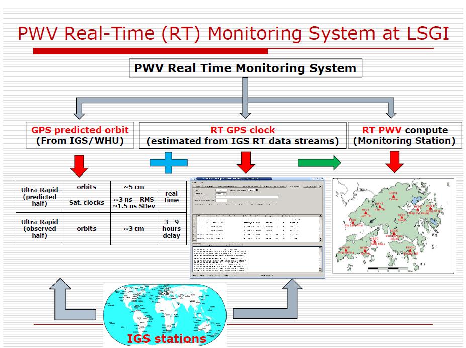
9 Develop an GNSS based infrastructure to support Economic Development in HK 1. Develop multiple PNT services to support Hong Kong economic development and for the public to obtain reliable and accurate positioning data at low cost 2. Utilizing multiple GNSS positioning systems (i.e. GPS, Beidou, GLONASS), together with ground based augmentation systems, to solve urban positioning problem, and to provide reliable and secured positioning services 3. Develop better algorithms and models to improve positioning performance under the disturbances of ionosphere to improve accuracy and reliability of PNT services 4. Real-time Ionosphere Monitoring to support GNSS integrity and DGNSS services 5. 3D Water Vapour observation for weather forecasting 9
10 Collaboration with Government Agencies and Industries Development Users HK LD HK Post HK LD PolyUl Hong Kong Positioning Infrastructure HK PD 10 Companies LSCM HK CEDD Autotoll 10


11 Reliable 3D RTK services Platform of multiple GNSS to support RTK centimeter positioning Establish an multiple GNSS network (include GPS/Beidou/ ) Provide reliable RTK positioning service High quality geoid height at user site Support single-frequency RTK Other users server Multiple GNSS network 11

12 Concept of GNSS heighting 12
13 Gravity Survey Arrangement Gravity Survey: 635 points (46 old gravity points) GPS/levelling control points: 136 points Evaluation of gravity survey results: 69 check points, accuracy is 0.02mgal 13
 14")
14 Hong Kong Geoid Model (1 cm) 14

15 Multiple GNSS Systems GPS only: 12 GPS+GLONASS+Beidou: 33 15
 Height (mm)")

16 GNSS Positioning in different environments Distance (mm) Height (mm) BeiDou - - GLONASS with BeiDou - - GPS - - GPS with BeiDou GPS with GLONASS
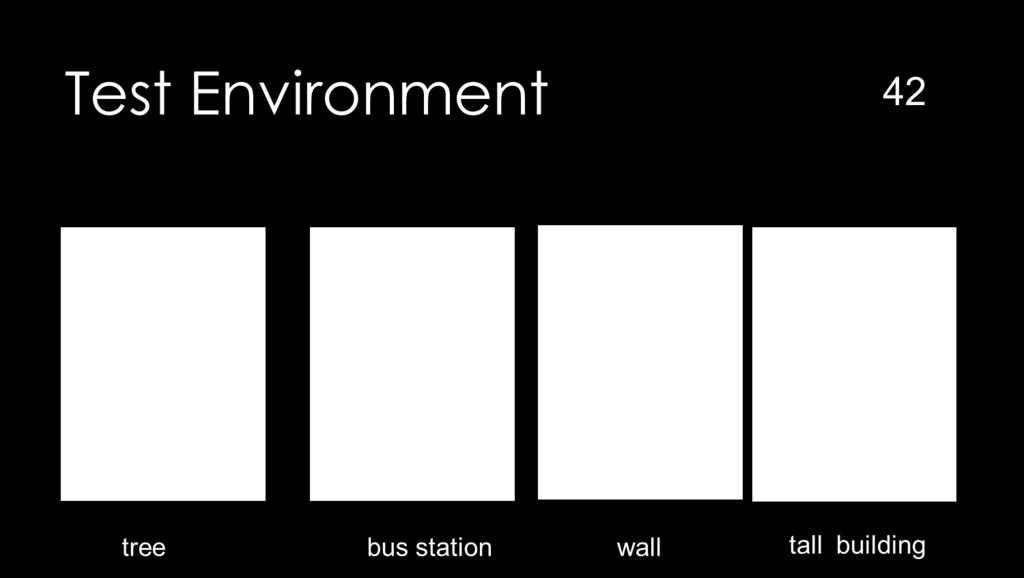
17 17


18 Field Experiments GPS/GLONASS GPS/Beidou/ GLONASS DGNSS Ambiguity Float Solution Ambiguity Fixed Solution


19 System Architecture for DGNSS GPS Beidou GLONASS Reference Poles GPS enabled Mobile Device GNSS observation Measurements or NMEA Data RTCM Correction Data ( X, Y, Z) Logistic Application Server Platform Lands Department Active GNSS network 19


20 Mobilephone DGNSS Tests 20
 Mean Rms RTK Mobile 4.0 4.1 DGNSS 1.5 1.9-1.")
21 N(m) x Pos err(m) Mean Rms RTK Mobile DGNSS E(m) 21


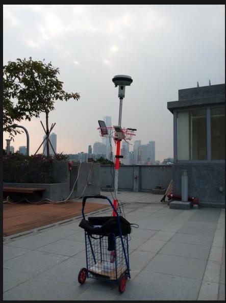
22 Vehicle Test 22
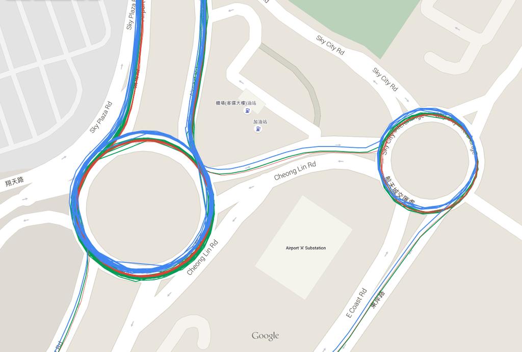
23 23

24 Multipath Mitigation for mobile users Reflected Path Immigration Department Direct Path Direct Path Blocked (NLOS) N E

25 Paths of All GNSS Satellites N E


26 GNSS: urban areas, Multipath Mitigation Urban area: multipath, errors can reach a few tens meters Using multipath mitigation algorithms: <10 m Tests in Mongkok
")
 N E 26.0 12.5 7.")
27 Wanchai: Multipath Mitigation NMEA (red) Multipath mitigation (Green) N E
28 28

29 Spatial distribution of water vapor 29

30 Height (km) Height (km) Electron Density Distribution in HK Reconstructed electron density distributions on 1 March 2011 (12:00 LT and 14:00 LT ) Electron Density Distributions over Hong Kong Date:March 1, 2001 Local Time: 12:00-13:00 Electron Density Unit: Ne/cm e+006 Electron Density Distributions over Hong Kong Date:March 1, 2001 Local Time: 14:00-15:00 Electron Density Unit: Ne/cm e e e e e e e latitude (degree) latitude (degree) 30
31 Summary: Hong Kong GNSS Infrastructure Develop DGNSS services for HK Correction accuracy < 0.5 m Mobilephone ~ 2 m Dense Built-in Areas Accuracy < 10 m for mobile users Develop high precision HK Geoid model Accuracy ~ 1 cm Develop Multiple GNSS RTK service Accuracy ~ 1-2 cm (3D) Ionosphere monitoring Support DGNSS (accuracy and integrity) water vapour observation (support weather forecasting) 31
32 Thank you 32
Geoscience & Positioning, Navigation and Timing Services for Canadians
 Geoscience & Positioning, Navigation and Timing Services for Canadians Calvin Klatt, Ph.D. Director and Chief Geodesist Natural Resources Canada / Directeur et géodésien principal Ressources naturelles
One Source for Positioning Success
 novatel.com One Source for Positioning Success RTK, PPP, SBAS OR DGNSS. NOVATEL CORRECT OPTIMIZES ALL CORRECTION SOURCES, PUTTING MORE POWER, FLEXIBILITY AND CONTROL IN YOUR HANDS. NovAtel CORRECT is the
Challenges and Methods for Integrity Assurance in Future GNSS
 Challenges and Methods for Integrity Assurance in Future GNSS Igor Mozharov Division Head, Information and Analytical Center for PNT, Central Research Institute for Machine Building, Roscosmos igor.mozharov@mcc.rsa.ru
Introduction to GNSS Base-Station
 Introduction to GNSS Base-Station Dinesh Manandhar Center for Spatial Information Science The University of Tokyo Contact Information: dinesh@iis.u-tokyo.ac.jp Slide : 1 Introduction GPS or GNSS observation
Performance Evaluation of Differential Global Navigation Satellite System with RTK Corrections
 IOSR Journal of Electronics and Communication Engineering (IOSR-JECE) e-issn: 2278-2834,p- ISSN: 2278-8735.Volume 9, Issue 2, Ver. VI (Mar - Apr. 2014), PP 43-47 Performance Evaluation of Differential
Protection Augmentation Toughness and Alternatives of GNSS. Melaha 2016 Concord Al-Salam Hotel Cairo, April 25,2016 Refaat Rashad
 Protection Augmentation Toughness and Alternatives of GNSS Melaha 2016 Concord Al-Salam Hotel Cairo, April 25,2016 Refaat Rashad Road Map of the Presentation 1- How Good are GNSS 2- How Vulnerable are
The Global Positioning System II Field Experiments
 The Global Positioning System II Field Experiments 5-1 Mexico DGPS Field Campaign Cenotes in Tamaulipas, MX, near Aldama 5-2 Are Cenote Water Levels Related? 5-3 DGPS Static Survey of Cenote Water Levels
Case sharing of the use of RF Localization Techniques. Dr. Frank Tong LSCM R&D Centre LSCM Summit 2015
 Case sharing of the use of RF Localization Techniques Dr. Frank Tong LSCM R&D Centre LSCM Summit 2015 Outline A. LBS tracking and monitoring 1) Case of anti-wandering-off tracking vest system in elderly
Webinar. 9 things you should know about centimeter-level GNSS accuracy
 Webinar 9 things you should know about centimeter-level GNSS accuracy Webinar agenda 9 things you should know about centimeter-level GNSS accuracy 1. High precision GNSS challenges 2. u-blox F9 technology
The Global Positioning Sytem II 10/19/2017
 The Global Positioning System II Field Experiments 10/19/2017 5-1 Mexico DGPS Field Campaign Cenotes in Tamaulipas, MX, near Aldama 10/19/2017 5-2 Are Cenote Water Levels Related? 10/19/2017 5-3 M. Helper,
The International Scene: How Precise Positioning Will Underpin Critical GNSS Applications
 The International Scene: How Precise Positioning Will Underpin Critical GNSS Applications School of Civil & Environmental Engineering, UNSW, Sydney, Australia Chris Rizos Member of the IGS Governing Board
What makes the positioning infrastructure work. Simon Kwok Chairman, Land Surveying Division Hong Kong Institute of Surveyors
 What makes the positioning infrastructure work The experience of the Hong Kong Satellite Positioning Reference Station Network Simon Kwok Chairman, Land Surveying Division Hong Kong Institute of Surveyors
Satellite-Based Augmentation System (SBAS) Integrity Services
 Integrity Services") Satellite-Based Augmentation System (SBAS) Integrity Services Presented To: Munich, Germany Date: March 8, 2010 By: Leo Eldredge, Manager GNSS Group, FAA FAA Satellite Navigation Program 2 Wide Area Augmentation
Satellite-Based Augmentation System (SBAS) Integrity Services Presented To: Munich, Germany Date: March 8, 2010 By: Leo Eldredge, Manager GNSS Group, FAA FAA Satellite Navigation Program 2 Wide Area Augmentation
Compact multi-gnss PPP corrections messages for transmission through a 250 bps channel
 Compact multi-gnss PPP corrections messages for transmission through a 250 bps channel Ken Harima, School of Science, RMIT University Suelynn Choy, School of Science, RMIT University Chris Rizos, School
The added value of new GNSS to monitor the ionosphere
 The added value of new GNSS to monitor the ionosphere R. Warnant 1, C. Deprez 1, L. Van de Vyvere 2 1 University of Liege, Liege, Belgium. 2 M3 System, Wavre, Belgium. Monitoring TEC for geodetic applications
CLICK HERE TO KNOW MORE
 CLICK HERE TO KNOW MORE Should GNSS Become a National Critical Infrastructure? Ooi Wei Han, Noordin Ahmad, Shahrizal IM National Space Agency (ANGKASA) Ministry of Science, Technology and Innovation (MOSTI)
Lecture-1 CHAPTER 2 INTRODUCTION TO GPS
 Lecture-1 CHAPTER 2 INTRODUCTION TO GPS 2.1 History of GPS GPS is a global navigation satellite system (GNSS). It is the commonly used acronym of NAVSTAR (NAVigation System with Time And Ranging) GPS (Global
Generation of Consistent GNSS SSR Corrections
 Generation of Consistent GNSS SSR Corrections for Distributed CORS Networks Jannes Wübbena, Martin Schmitz, Gerhard Wübbena Geo++ GmbH 30827 Garbsen, Germany www.geopp.de Abstract Generation of Consistent
High Precision Applications with BeiDou
 High Precision Applications with BeiDou Lei HUANG Unicore Communications, Inc May 14, 2013 Contents 1 2 3 4 Background Overview of BeiDou high precision products Applications of BeiDou high precision products
in the economy United Nations Eleventh Meeting of the International Committee on Global Navigation Satellite Systems (ICG-11) and the 17th Meeting of
 and the 17th Meeting of") Applications of highprecision GNSS solutions in the economy United Nations Eleventh Meeting of the International Committee on Global Navigation Satellite Systems (ICG-11) and the 17th Meeting of the Providers'
Applications of highprecision GNSS solutions in the economy United Nations Eleventh Meeting of the International Committee on Global Navigation Satellite Systems (ICG-11) and the 17th Meeting of the Providers'
PRELIMINARY PROGRAMME
 ICG EXPERTS MEETING: GLOBAL NAVIGATION SATELLITE SYSTEMS SERVICES 14-18 December 2015 Vienna International Centre, Vienna, Austria Organized by International Committee on Global Navigation Satellite Systems
NYSNET 11/28/2014 GPS/GLONASS (GG) January 2015 NYSAPLS Conference
 January 2015 NYSAPLS Conference") GPS/GLONASS (GG) January 2015 NYSAPLS Conference 2015 1 NYSNet 2015 GLONASS Upgrades Antenna Types Single Base/Network RTK GPS/GLONASS (GG) Single Base GPS/GLONASS (GG) Network RTK RT Products (NTRIP Mount
GPS/GLONASS (GG) January 2015 NYSAPLS Conference 2015 1 NYSNet 2015 GLONASS Upgrades Antenna Types Single Base/Network RTK GPS/GLONASS (GG) Single Base GPS/GLONASS (GG) Network RTK RT Products (NTRIP Mount
FieldGenius Technical Notes GPS Terminology
 FieldGenius Technical Notes GPS Terminology Almanac A set of Keplerian orbital parameters which allow the satellite positions to be predicted into the future. Ambiguity An integer value of the number of
AGENDA. NEI Overview. Mobile platforms with the new R1 / R2 GNSS receiver. High Accuracy Cloud Based Data Collection. Geo 7X Higher Accuracy Option
 AGENDA NEI Overview Mobile platforms with the new R1 / R2 GNSS receiver High Accuracy Cloud Based Data Collection Geo 7X Higher Accuracy Option Selecting - the Right Tool for the Right Job Field to Finish.
Leica MNS1200 GNSS Series Toughest GNSS solution for toughest sites
 Leica MNS1200 GNSS Series Toughest GNSS solution for toughest sites >Fast >Smart >Integrated Leica MNS1200 GNSS Series Robust GNSS machine navigation solution The Leica MNS1200 GNSS (Global Navigation
GNSS Technology Update
 GNSS Technology Update Speaker: Eric Gakstatter Contributing Editor GPS World Editor - Geospatial Solutions Presented at: Association of Petroleum Surveying & Geomatics Houston, TX April 7, 2015 Agenda
MGA Webinar Series : 1 Very Cheap RTK Receivers: Changing the Landscape of Positioning Services
 MGA Webinar Series : 1 Very Cheap RTK Receivers: Changing the Landscape of Positioning Services Dinesh Manandhar Center for Spatial Information Science The University of Tokyo Contact Information: dinesh@iis.u-tokyo.ac.jp
GNSS Training for ITS Developers. 1 - GNSS Principles
 GNSS Training for ITS Developers 1 - GNSS Principles Table of Content Introduction to Satellite Navigation Systems Basics on GNSS Receivers Galileo, the European GNSS EGNOS, the European Augmentation System
High Precision GNSS in Automotive
 High Precision GNSS in Automotive Jonathan Auld, VP Engineering and Safety 6, March, 2018 2 Global OEM Positioning Solutions and Services for Land, Sea, and Air. GNSS in Automotive Today Today the primary
The Reasons to Succeed or to Fail a GNSS Network RTK Project
 The Reasons to Succeed or to Fail a GNSS Network RTK Project Joël van Cranenbroeck, Managing Director CGEOS Creative Geosensing sprl-s, Belgium Andy Yin, International Sales Director ComNav Technology
Space Weather influence on satellite based navigation and precise positioning
 Space Weather influence on satellite based navigation and precise positioning R. Warnant, S. Lejeune, M. Bavier Royal Observatory of Belgium Avenue Circulaire, 3 B-1180 Brussels (Belgium) What this talk
SBAS solution GCC, Yemen and Iraq System baseline and performance
 SBAS solution GCC, Yemen and Iraq System baseline and performance ACAC Workshop Rabat 7 & 8 November 2017 1 2017 Thales Alenia Space PROPRIETARY C O M MINFORMATION E R C I A L I N THALES C O ALENIA N F
GBAS-Technologies for High Precise Safety-Critical Maritime Navigation
 GBAS-Technologies for High Precise Safety-Critical Maritime Navigation S. Schlüter, E. Engler, T. Noack, J. Beckheinrich, A. Hirrle, C. Becker, D. Klähn Abstract As a result of the high quality of positioning
Aviation Benefits of GNSS Augmentation
 Aviation Benefits of GNSS Augmentation Workshop on the Applications of GNSS Chisinau, Moldova 17-21 May 2010 Jeffrey Auerbach Advisor on GNSS Affairs Office of Space and Advanced Technology U.S. Department
Understanding GPS: Principles and Applications Second Edition
 Understanding GPS: Principles and Applications Second Edition Elliott Kaplan and Christopher Hegarty ISBN 1-58053-894-0 Approx. 680 pages Navtech Part #1024 This thoroughly updated second edition of an
Utilizing A GNSS Network Solution for Utility Applications
 Utilizing A GNSS Network Solution for Utility Applications David Newcomer, PE, PLS GPServ, Inc. newcomer@ (407) 601-5816 AGENDA Types and accuracies of data collection o Autonomous o Meter + o Sub-meter
ION ITM Tokyo University of Marine Science and Technology H. Sridhara, N. Kubo, R.Kikuchi
 Single-Frequency Multi-GNSS RTK Positioning for Moving Platform ION ITM 215 215.1.27-29 Tokyo University of Marine Science and Technology H. Sridhara, N. Kubo, R.Kikuchi 1 Agenda Motivation and Background
GE 113 REMOTE SENSING
 GE 113 REMOTE SENSING Topic 9. Introduction to Global Positioning Systems (GPS) and Other GNSS Technologies Lecturer: Engr. Jojene R. Santillan jrsantillan@carsu.edu.ph Division of Geodetic Engineering
GNSS Low-Cost High-Accuracy Receiver (L-CHAR)
") GNSS Low-Cost High-Accuracy Receiver (L-CHAR) Dinesh Manandhar Center for Spatial Information Science The University of Tokyo Contact Information: dinesh@iis.u-tokyo.ac.jp Slide : 1 High Accuracy Receivers
GNSS Low-Cost High-Accuracy Receiver (L-CHAR) Dinesh Manandhar Center for Spatial Information Science The University of Tokyo Contact Information: dinesh@iis.u-tokyo.ac.jp Slide : 1 High Accuracy Receivers
INTERNATIONAL CIVIL AVIATION ORGANIZATION
 INTERNATIONAL CIVIL AVIATION ORGANIZATION AFI PLANNING AND IMPLEMENTATION REGIONAL GROUP EIGHTEENTH MEETING (APIRG/18) Kampala, Uganda (27 30 March 2012) Agenda Item 3: Performance Framework for Regional
Precise Positioning... what does it mean? Precise GNSS Positioning Not just a niche technology. Chris Rizos 15/12/15
 Precise GNSS Positioning Not just a niche technology Chris Rizos Precise Positioning... what does it mean? 1 Precise Positioning... a spectrum of users... Few mm 1cm 2cm < dm 1dm sub-m Precision agriculture
Galileo - European Global Navigation Satellite System
 Abstract Galileo - European Global Navigation Satellite System Wu Chen Department of Land Surveying and Geoinformatics Hong Kong Polytechnic University e-mail: Lswuchen@polyu.du.hk Washington Yotto Ochieng
Beginners Guide to GPS Elevation Plus an Update on GPS Technology
 Beginners Guide to GPS Elevation Plus an Update on GPS Technology A TMS Presentation By: Jon Aschenbach Summerlake Enterprises 919 36 th Place Forest Grove, OR 97116 503-707-6236 Coeur d Alene, ID April,
Challenges and Solutions for GPS Receiver Test
 Challenges and Solutions for GPS Receiver Test Presenter: Mirin Lew January 28, 2010 Agenda GPS technology concepts GPS and GNSS overview Assisted GPS (A-GPS) Basic tests required for GPS receiver verification
NCS TITAN. The most powerful GNSS Simulator available. NCS TITAN Datasheet. Scalability. Extendability. In co-operation with
 NCS TITAN The most powerful GNSS Simulator available Scalability Fidelity Reliability Usability Extendability Flexibility Upgradability Features Signal Capabilities Support of all global (GNSS) and regional
GPS Application. Global Positioning System. We provide GPS module ODM / OEM service, any GPS receiver you want, we can provide customized services.
 GPS Application Global Positioning System We provide GPS module ODM / OEM service, any GPS receiver you want, we can provide customized services. www.win-tec.com.tw sales@win-tec.com.tw GNSS Receiver WGM-303
Differential GPS Positioning over Internet
 Abstract Differential GPS Positioning over Internet Y. GAO AND Z. LIU Department of Geomatics Engineering The University of Calgary 2500 University Drive N.W. Calgary, Alberta, Canada T2N 1N4 Email: gao@geomatics.ucalgary.ca
GNSS-based Flight Inspection Systems
 GNSS-based Flight Inspection Systems Euiho Kim, Todd Walter, and J. David Powell Department of Aeronautics and Astronautics Stanford University Stanford, CA 94305, USA Abstract This paper presents novel
Positioning, location data and GNSS as solution for Autonomous driving
 Positioning, location data and GNSS as solution for Autonomous driving Jarkko Koskinen, Heidi Kuusniemi, Juha Hyyppä, Sarang Thombre and Martti Kirkko-Jaakkola FGI, NLS Definition of the Arctic 66 34 N
Next Generation Positioning Infrastructure
 Next Generation Positioning Infrastructure The GNSS Network in the 21 st Century Joel VAN CRANENBROECK & Partners Beyond East & West GeoSensing Community 1 INFRASTRUCTURE "The installations that form the
Global Navigation Satellite System (GNSS) for Disaster Mitigation
 for Disaster Mitigation") Global Navigation Satellite System (GNSS) for Disaster Mitigation By Chathura H. Wickramasinghe Geoinformatics Center Asian Institute of Technology Establish in 1959 as a Post Graduate School Catering
Global Navigation Satellite System (GNSS) for Disaster Mitigation By Chathura H. Wickramasinghe Geoinformatics Center Asian Institute of Technology Establish in 1959 as a Post Graduate School Catering
Trustworthy Positioning for Next Generation Intelligent Transport Systems Ahmed El-Mowafy
 Trustworthy Positioning for Next Generation Intelligent Transport Systems Ahmed El-Mowafy Contents Background on ITS and C-ITS Requirements Challenges RAIM Test and Results Utilisation Workshop, Sydney,
Report of the Working Group B: Enhancement of Global Navigation Satellite Systems (GNSS) Services Performance
 Services Performance") Report of the Working Group B: Enhancement of Global Navigation Satellite Systems (GNSS) Services Performance 1. The Working Group on Enhancement of Global Navigation Satellite Systems (GNSS) Service Performance
Report of the Working Group B: Enhancement of Global Navigation Satellite Systems (GNSS) Services Performance 1. The Working Group on Enhancement of Global Navigation Satellite Systems (GNSS) Service Performance
SKPOS. Slovak real-time positioning service - a multifunctional tool for precise object and phenomena positioning
 SKPOS Slovak real-time positioning service - a multifunctional tool for precise object and phenomena positioning WHAT IS SKPOS AND HOW DOES IT WORK? Slovak real-time positioning service is a multifunctional
GNSS Accuracy Improvements through Multipath Mitigation with New Signals and services
 GNSS Accuracy Improvements through Multipath Mitigation with New Signals and services Andrey Veytsel, Ph.D Moscow Technical University 10 Meeting of the International Committee on Global Navigation Satellite
Report of Working Group B: Enhancement of Global Navigation Satellite Systems Services Performance
 Report of : Enhancement of Global Navigation Satellite Systems Services Performance 1. The Working Group on Enhancement of Global Navigation Satellite Systems (GNSS) Service Performance (WG-B) of the International
METIS Second Master Training & Seminar. Augmentation Systems Available in Egypt
 METIS Second Master Training & Seminar Augmentation Systems Available in Egypt By Eng. Ramadan Salem M. Sc. Surveying and Geodesy Email: ramadan_salem@link.net Page 1 Augmentation Systems Available in
LSD PQSL Series Geodetic Survey. Prepared by Mr KWOK King-hung 22 May 2015
 LSD PQSL Series 2015 Geodetic Survey Prepared by Mr KWOK King-hung 22 May 2015 1 Geodesy Source from Wiki May 2015 also known as geodetics or geodetics engineering a branch of applied mathematics and earth
GNSS 101 Bringing It Down To Earth
 GNSS 101 Bringing It Down To Earth Steve Richter Frontier Precision, Inc. UTM County Coordinates NGVD 29 State Plane Datums Scale Factors Projections Session Agenda GNSS History & Basic Theory Coordinate
DEFINING THE FUTURE OF SATELLITE SURVEYING WITH TRIMBLE R-TRACK TECHNOLOGY
 DEFINING THE FUTURE OF SATELLITE SURVEYING WITH TRIMBLE R-TRACK TECHNOLOGY EDMOND NORSE, GNSS PORTFOLIO MANAGER, TRIMBLE SURVEY DIVISION WESTMINSTER, CO USA ABSTRACT In September 2003 Trimble introduced
GLOBAL POSITIONING SYSTEMS. Knowing where and when
 GLOBAL POSITIONING SYSTEMS Knowing where and when Overview Continuous position fixes Worldwide coverage Latitude/Longitude/Height Centimeter accuracy Accurate time Feasibility studies begun in 1960 s.
Development of a GAST-D ground subsystem prototype and its performance evaluation with a long term-data set
 Development of a GAST-D ground subsystem prototype and its performance evaluation with a long term-data set T. Yoshihara, S. Saito, A. Kezuka, K. Hoshinoo, S. Fukushima, and S. Saitoh Electronic Navigation
GNSS in the Arctic. by Arne Rinnan, Kongsberg Seatex AS. WORLD CLASS through people, technology and dedication
 GNSS in the Arctic by Arne Rinnan, Kongsberg Seatex AS WORLD CLASS through people, technology and dedication Outline Introduction Weather conditions Satellite coverage Aurora impact GNSS corrections Test
Radio Navigation Aids Flight Test Seminar
 Radio Navigation Aids Flight Test Seminar FLIGHT INSPECTION IN THE NEW MILLENNIUM Curt Keedy FAA Flight Inspection Policy and Standards Change, Challenge, and Opportunity CHANGES Global Positioning system
DYNAMIC RT TECHNOLOGY
 DYNAMIC RT TECHNOLOGY GLOBAL NAVIGATION SATELLITE SYSTEMS (GNSS) POTENTIAL FUTURE DEVELOPMENTS(2005 2017?) GPS MODERNIZATION BLOCK IIF & III GLONASS ENHANCEMENTS (K & M) EUROPEAN UNION - GALILEO CHINA
Real-Time and Multi-GNSS Key Projects of the International GNSS Service
 Real-Time and Multi-GNSS Key Projects of the International GNSS Service Urs Hugentobler, Chris Rizos, Mark Caissy, Georg Weber, Oliver Montenbruck, Ruth Neilan EUREF 2013 Symposium Budapest, Hungary, May
PPS usable by timing applications via serial port emulation
 Timing & Navigation Module z051 USB GNSS Dongle with PPS* PPS usable by timing applications via serial port emulation * The Pulse Per Second (PPS) is an electrical signal that very precisely indicates
GPS/WAAS Program Update
 GPS/WAAS Program Update UN/Argentina Workshop on the Applications of GNSS 19-23 March 2018 Cordoba, Argentina GNSS: A Global Navigation Satellite System of Systems Global Constellations GPS (24+3) GLONASS
Bernhard Hofnlann-Wellenhof Herbert Lichtenegger Elmar Wasle. GNSS - Global Navigation Satellite Systenls. GPS, GLONASS, Galileo, and nl0re
 Bernhard Hofnlann-Wellenhof Herbert Lichtenegger Elmar Wasle GNSS - Global Navigation Satellite Systenls GPS, GLONASS, Galileo, and nl0re SpringerWienNewYork Contents Abbreviations xxi 1 Introduction 1
Evaluation of Multi-Constellation GNSS Precise Point Positioning (PPP) Techniques in Egypt
 Techniques in Egypt") Evaluation of Multi-Constellation GNSS Precise Point Positioning (PPP) Techniques in Egypt Mahmoud Abd Rabbou and Adel El-Shazly Department of Civil Engineering, Cairo University Presented by; Dr. Mahmoud
Evaluation of Multi-Constellation GNSS Precise Point Positioning (PPP) Techniques in Egypt Mahmoud Abd Rabbou and Adel El-Shazly Department of Civil Engineering, Cairo University Presented by; Dr. Mahmoud
CHC MINING DEFORMATION MONITORING SOLUTION
 CHC MINING DEFORMATION MONITORING SOLUTION Safety is first in mining. CHC offers solutions designed to improve safety for personnel on the ground and in the cab with 24/7 precision positioning for automatic
School of Civil & Environmental Engineering, UNSW, Sydney, Australia. Chris Rizos. President Australian Institute of Navigation
 The Threat to Space Based Service (for PNT applications) School of Civil & Environmental Engineering, UNSW, Sydney, Australia Chris Rizos President Australian Institute of Navigation Outline GNSS... a
GLONASS-based Single-Frequency Static- Precise Point Positioning
 GLONASS-based Single-Frequency Static- Precise Point Positioning Ashraf Farah College of Engineering Aswan University Aswan, Egypt e-mail: ashraf_farah@aswu.edu.eg Abstract Precise Point Positioning (PPP)
Precise Positioning with NovAtel CORRECT Including Performance Analysis
 Precise Positioning with NovAtel CORRECT Including Performance Analysis NovAtel White Paper April 2015 Overview This article provides an overview of the challenges and techniques of precise GNSS positioning.
C94-M8P Application Board Setup Guide
 C94-M8P Application Board Setup Guide locate, communicate, accelerate UBX-16009722 R02 C94-M8P Board Connections and Interfaces J1 J10 J2 J3 J1: RS232 UART M8P/Radio J2: USB M8P J3: External battery /
Precise GNSS Positioning for Mass-market Applications
 Precise GNSS Positioning for Mass-market Applications Yang GAO, Canada Key words: GNSS, Precise GNSS Positioning, Precise Point Positioning (PPP), Correction Service, Low-Cost GNSS, Mass-Market Application
EGNOS/EDAS based solution for the French DGPS network. Author: Etienne LEROY
 EGNOS/EDAS based solution for the French DGPS network. Author: Etienne LEROY Date 04/10/2017 1.Context 2.EDAS Centralized based architecture 3.Software and devices 4.Test Campaign 5.Cost based analysis
The Future of Global Navigation Satellite Systems
 The Future of Global Navigation Satellite Systems Chris RIZOS School of Surveying & Spatial Information Systems University of New South Wales Sydney, NSW 2052, AUSTRALIA E-mail: c.rizos@unsw.edu.au Abstract
The Benefits of Three Frequencies for the High Accuracy Positioning
 The Benefits of Three Frequencies for the High Accuracy Positioning Nobuaki Kubo (Tokyo University of Marine and Science Technology) Akio Yasuda (Tokyo University of Marine and Science Technology) Isao
Performance Evaluation of the Effect of QZS (Quasi-zenith Satellite) on Precise Positioning
 on Precise Positioning") Performance Evaluation of the Effect of QZS (Quasi-zenith Satellite) on Precise Positioning Nobuaki Kubo, Tomoko Shirai, Tomoji Takasu, Akio Yasuda (TUMST) Satoshi Kogure (JAXA) Abstract The quasi-zenith
Performance Evaluation of the Effect of QZS (Quasi-zenith Satellite) on Precise Positioning Nobuaki Kubo, Tomoko Shirai, Tomoji Takasu, Akio Yasuda (TUMST) Satoshi Kogure (JAXA) Abstract The quasi-zenith
Experiences with Fugro's Real Time GPS/GLONASS Orbit/Clock Decimeter Level Precise Positioning System
 Return to Session Directory DYNAMIC POSITIONING CONFERENCE October 13-14, 2009 Sensors Experiences with Fugro's Real Time GPS/GLONASS Orbit/Clock Decimeter Level Precise Positioning System Ole Ørpen and
Current status of Quasi-Zenith Satellite System. Japan Aerospace Exploration Agency QZSS Project Team
 Current status of Quasi-Zenith Satellite System Japan Aerospace Exploration Agency QZSS Project Team 1 Quasi-Zenith Satellite System The QZSS is a regional space-based PNT (Positioning, Navigation and
Indian Institute of Technology Kanpur Department of Civil Engineering
 Indian Institute of Technology Kanpur Department of Civil Engineering Inquiry No- CE/JNM/2013-14/R-10 30 December, 2013 Subject: Quotation for supply of Integrated System/Smart System Reflectorless Robotic
Introduction to Total Station and GPS
 Introduction to Total Station and GPS Dr. P. NANJUNDASWAMY Professor of Civil Engineering J S S Science and Technology University S J College of Engineering Mysuru 570 006 Introduction History GPS Overview
Report on a Multi-GNSS Demonstration project in the Asia/Oceania region
 Report on a Multi-GNSS Demonstration project in the Asia/Oceania region - Asia Oceania is the Showcase of New GNSS Era - Japan Aerospace Exploration Agency ICG 5@Turin, Italy October 19, 2010 1 Back Ground
The topic we are going to see in this unit, the global positioning system, is not directly related with the computer networks we use everyday, but it
 The topic we are going to see in this unit, the global positioning system, is not directly related with the computer networks we use everyday, but it is indeed a kind of computer network, as the specialised
Understanding GPS/GNSS
 Understanding GPS/GNSS Principles and Applications Third Edition Contents Preface to the Third Edition Third Edition Acknowledgments xix xxi CHAPTER 1 Introduction 1 1.1 Introduction 1 1.2 GNSS Overview
السلطة البحرية االردنية Jordan Maritime Authority
 السلطة البحرية االردنية السلطة البحرية االردنية Humans have always been interested in where things are السلطة البحرية االردنية One of the basic questions have always been where I am? which leads to where
European GNSS: Galileo and EGNOS for next generation Road Charging
 European GNSS: Galileo and EGNOS for next generation Road Charging 20 th October 2014 Gian Gherardo Calini European GNSS Agency (GSA) GNSS have made a huge impact in our society it is key in Road transportation
SATELLITE BASED AUGMENTATION SYSTEM (SBAS) FOR AUSTRALIA
 FOR AUSTRALIA") SATELLITE BASED AUGMENTATION SYSTEM (SBAS) FOR AUSTRALIA AN AIN POSITION PAPER SUBMITTED TO VARIOUS GOVERNMENT DEPARTMENTS BY MR KYM OSLEY AM, CSC, EXEC SECRETARY AIN What are GNSS Augmentation Systems?
SATELLITE BASED AUGMENTATION SYSTEM (SBAS) FOR AUSTRALIA AN AIN POSITION PAPER SUBMITTED TO VARIOUS GOVERNMENT DEPARTMENTS BY MR KYM OSLEY AM, CSC, EXEC SECRETARY AIN What are GNSS Augmentation Systems?
Asian Journal of Science and Technology Vol. 08, Issue, 11, pp , November, 2017 RESEARCH ARTICLE
 Available Online at http://www.journalajst.com ASIAN JOURNAL OF SCIENCE AND TECHNOLOGY ISSN: 0976-3376 Asian Journal of Science and Technology Vol. 08, Issue, 11, pp.6697-6703, November, 2017 ARTICLE INFO
ATLANS-C. mobile mapping position and orientation solution
 mobile mapping position and orientation solution mobile mapping position and orientation solution THE SMALLEST ATLANS-C is a high performance all-in-one position and orientation solution for both land
Indoor Navigation and the. Conferest Demo App
 Indoor Navigation and the Presented at the FIG Working Week 2017, May 29 - June 2, 2017 in Helsinki, Finland Conferest Demo App Dept. of Navigation and Positioning Finnish Geospatial Research Institute
GNSS Positioning STATUS AND FEATURES
 STATUS AND FEATURES GNSS Positioning Nowadays, GNSS receivers have scores and often more than one hundred of channels, enabling them to track GPS, Glonass, Galileo and Compass signals simultaneously. The
Motion & Navigation Solution
 Navsight Land & Air Solution Motion & Navigation Solution FOR SURVEYING APPLICATIONS Motion, Navigation, and Geo-referencing NAVSIGHT LAND/AIR SOLUTION is a full high performance inertial navigation solution
GPS/GNSS What is it? How Does it Work? What are its Applications?
 GPS/GNSS What is it? How Does it Work? What are its Applications? Historic Navigation Reference points in the sky used for navigation The Sun The Pole Star / North Star Southern Cross Gives Direction,
Low-Cost GNSS for Geodetic Applications
 Institut für Ingenieurgeodäsie Presented at the FIG Congress 2018, May 6-11, 2018 in Istanbul, Turkey Low-Cost GNSS for Geodetic Applications Dr.-Ing. Li Zhang Institute of Engineering Geodesy (IIGS),
Specifications. Trimble BX982 Modular GNSS Heading Receiver
 Name Configuration Option Base and Rover interchangeability Rover position update rate Rover maximum range from base radio Rover operation within a VRS network Heading and Moving Base operation Factory
GBAS FOR ATCO. June 2017
 GBAS FOR ATCO June 2017 Disclaimer This presentation is for information purposes only. It should not be relied on as the sole source of information, and should always be used in the context of other authoritative
Nigerian Communications Satellite Ltd. (NIGCOMSAT)
") OVERVIEW OF NIGERIAN SATELLITE AUGMENTATION SYSTEM COMMENCING WITH PILOT DEMONSTRATION TO VALIDATE NATIONAL WORK PLAN presented by Dr. Lawal Lasisi Salami, NIGERIAN COMMUNICATIONS SATELLITE LTD UNDER FEDERAL
OVERVIEW OF NIGERIAN SATELLITE AUGMENTATION SYSTEM COMMENCING WITH PILOT DEMONSTRATION TO VALIDATE NATIONAL WORK PLAN presented by Dr. Lawal Lasisi Salami, NIGERIAN COMMUNICATIONS SATELLITE LTD UNDER FEDERAL