The added value of new GNSS to monitor the ionosphere
|
|
|
- Neil Atkinson
- 6 years ago
- Views:
Transcription
1 The added value of new GNSS to monitor the ionosphere R. Warnant 1, C. Deprez 1, L. Van de Vyvere 2 1 University of Liege, Liege, Belgium. 2 M3 System, Wavre, Belgium.
2 Monitoring TEC for geodetic applications For the last 25 years, GPS L1/L2 code and phase pseudoranges have been used to monitor the ionosphere Total Electron Content (TEC). Both absolute TEC and Rate of TEC change are crucial parameters for the mitigation of the ionospheric effects on GNSS applications. Nevertheless, GPS L1/L2 TEC reconstruction suffers from different shortcomings. We investigate if new/modernized GNSS can bring improvements in: Reconstructed TEC precision (not accuracy). The monitoring of local variability in TEC (Travelling Ionospheric Disturbances)
3 Absolute TEC 1 Absolute Slant TEC can be reconstructed from code and/or phase geometryfree combinations : i 1 i i i i i STEC p, kl kl ( Pp, k Pp, l ) ( dkl d p, kl ) M p, kl p, kl Code/phase GF InterFrequency Slant TEC at frequencies rec. and Multipath Noise f k and f l sat. biases Phase ambiguity STEC ( ) ( ) m ( ) i 1 i i i i i i i p, kl kl p, k p, l kl p, kl p, kl p, kl k p, k l p, l 1 1 kl 40.3 f f 2 2 k l
4 Absolute TEC 2 Absolute TEC precision/accuracy mainly depends on : Code and/or phase pseudorange precision (noise). 1 The TEC coefficient α kl which depends on the considered frequency pair (should be as small as possible large frequency difference) Residual errors : multipath, IF biases Ambiguities when phase observables are used (main influence on accuracy)
5 Rate of TEC change 1 Between epoch change in slant TEC can be used to monitor local variability in TEC due to moving structures. i i i STEC p, kl ( tk ) STEC p, kl ( tk ) STEC p, kl ( tk 1) Can be mapped to vertical and/or normalized (to 1 minute interval). This combination removes biases (constant part of IF delays, ambiguities) but it still depends on noise and on between epoch variation of TEC, multipath and IF biases (usually considered as negligible).
6 Rate of TEC change 2 Local variability in TEC at European mid-latitudes (Belgium): Mainly due Travelling Ionospheric Disturbances (affect precise positioning). GPS-based detection of moving structures (TIDs) is «biased» by the fact that ionospheric points have a velocity wrt the ionosphere due to satellite orbital motion.


7 New/modernized GNSS 1 GPS GLONASS Galileo QZSS Beidou NAVIC SBAS
8 New/modernized GNSS 2 More (than 2) frequencies: Possible to form several frequency pairs to reconstruct TEC (influence on α kl Improved signals : Better resistance to multipath New modulation techniques allowing to perform more precise code pseudorange measurements. 1 )
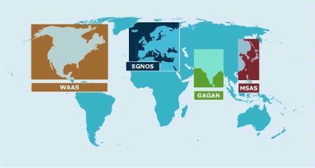
9 New/modernized GNSS 3 Availability of (dual or triple frequency) geostationary navigation satellites SBAS (2F): EGNOS, GAGAN, WAAS. Beidou (3F): C01 to C05. As GEO satellites have a negligible velocity wrt respect to the ionosphere, they could be interesting for the study of local variability in TEC. Availability of new generation receivers and antennas which already bring improvement in the standard GPS L1/L2 case.
10 Multi GNSS/multi-frequency TEC precision
.")
.")
11 GNSS equipment Located in Liege (Belgium). 2 Trimble GNSS choke ring antennas on a short baseline (5,352 m). 6 multi-gnss/multi-frequency receivers : 2 Trimble NetR9 receivers 2 Septentrio PolaRx4 receivers 1 Septentrio PolaRxS scintillation receiver 1 Septentrio PolaRx5 (new model). Equipment used to perform zero and short baseline tests for positioning and ionosphere monitoring.

12 GNSS signals : GPS L5 L2 L1

13 GNSS signals : Galileo E5a E5 E5b E6 E1 Only available with PolaRx5

14 GNSS signals : Beidou (phase II) B2 B3 B1 Only available on NetR9 and PolaRx5
15 Different TEC coefficients Given the same code/phase precision, a larger frequency difference gives a smaller TEC coefficient and therefore a better TEC precision. TEC coefficients Galileo GPS Beidou E1-E5a E1-E5b E1-E5 E1-E6 L1-L2 L1-L5 L2-L5 B1-B2 B1-B3 7,764 8,757 8,24 11,893 9,52 7,764 42,089 8,993 11,754
16 Methodology to asses TEC precision Compute Slant TEC change from epoch to epoch (30 s interval) i i i STEC p, kl ( tk ) STEC p, kl ( tk ) STEC p, kl ( tk 1) Form single (between receiver) differences of STEC(t k ) on ULg short baseline (5,352 m): Completely removes TEC (same ionosphere). Still contains multipath and noise. TEC precision is estimated by computing the standard deviation of single differences of STEC t k (10 day period) and by dividing them by 2 (error propagation).
17 Results: code (multipath filter off - mask 10 ) 6 Code TEC precision (TECU) E1-E5a E1-E5b E1-E5 L1-L2 L1-L5 B1-B2 B1-B3 Galileo GPS Beidou MEO Septentrio Trimble Strong improvement in code TEC precision with Galileo (in particular E1/E5) wrt the standard GPS L1/L2.
18 Results: code (multipath filter on - mask 20 ) 2,5 Septentrio Code TEC precision (TECU) 2 1,5 1 0,5 0 E1-E5a E1-E5b E1-E5 L1-L2 L1-L5 B1-B2 B1-B3 Galileo GPS Beidou MEO Galileo E1/E5 combination has a precision better than 1 TECU above 20 elevation (Septentrio PolaRx4).
19 Results: Phase (multipath filter off - mask 10 ) 0,018 Phase TEC precision (TECU) 0,016 0,014 0,012 0,01 0,008 0,006 0,004 0,002 0 E1-E5a E1-E5b E1-E5 L1-L2 L1-L5 B1-B2 B1-B3 Galileo GPS Beidou MEO Septentrio Trimble
20 Galileo E1-E5 Slant TEC (code versus phase) TEC could directly be obtained from code measurements : No phase ambiguity to compute. No problem with cycle slips, in particular during disturbed ionosphere conditions.
21 Galileo E1-E5 RoTEC (code versus phase) Nevertheless, a strong TID cannot be extracted from code noise.
22 GEO satellites for ionosphere monitoring
 S127 (16 ) EGNOS (Europe) S123 (27 ) S136 (32 ) C05 GAGAN S127 C02 EGNOS S123 and")
23 GEO at European mid-latitude (Liege, Belgium) Beidou C02 (1-2 ) C05 (15 ) SBAS GAGAN (India) S127 (16 ) EGNOS (Europe) S123 (27 ) S136 (32 ) C05 GAGAN S127 C02 EGNOS S123 and S136
24 Beidou GEO In Liege (Belgium), Beidou GEO satellites C05 (15 ) and C02 (1-2 ) can be tracked by all Septentrio receivers. C05 data are continuous (in average less than 1 cycle slip a day). Phase ambiguity often remains the same during several days. C02 data are usually continuous during several hours (up to 24 hours). Our Trimble NetR9 receivers only track C05 but data are unusable due to many cycle slips.
25 Beidou GEO (Liege): Precision (phase) Beidou Phase TEC precision (TECU) 0,05 0,045 0,04 0,035 0,03 0,025 0,02 0,015 0,01 0,005 0 B1-B2 C05 B1-B2 C02 Given phase TEC accuracy (C05: 0,023 TECU) and (C02: 0,045 TECU), both satellites can be used to monitor slant TEC or local variability in TEC.

26 Beidou GEO : STEC Phase 1
27 Beidou GEO : STEC Phase 2 The variability observed in STEC could be due to between epoch variation of : TEC Multipath (at the station or at the satellite) IF biases (should be very small if any). For GEO satellites, multipath is expected to have : A repeatability of 1 sidereal day. A low frequency due to the slow variation of the geometry.
28 No daily repeatability
29 Similar signal for Liege and Brussels (about 100 km baseline)

30 Simsky 3F combination

31 DSTEC (TCU/30s) SBAS (Liege) First results show that STEC (phase) reconstructed from SBAS available in Liege is NOT precise enough to monitor TIDs (to be confirmed by further investigation).
32 Conclusions New/modernized GNSS combined with last generation receivers/antennas bring improvement in code and phase TEC accuracy (larger frequency difference, more precise code and phase observables more resistant to multipath). In particular, Code TEC precision is better than 1 TECU (above 20 elevation, multipath filter on, Septentrio PolaRx4) when using Galileo E1 and E5. Code only TEC reconstruction becomes an option. Not possible to detect even strong TIDs. In Liege, TEC reconstructed with Available SBAS is NOT precise enough to study local variability in TEC (to be confirmed); Beidou GEO provide a valuable tool to study moving structures in TEC.
33 Thanks for your attention!
Fast convergence of Trimble CenterPoint RTX by regional augmentation
 Fast convergence of Trimble CenterPoint RTX by regional augmentation Dr. Ralf Drescher Trimble Terrasat GmbH, Munich EGU General Assembly 2015, Vienna Thursday, 16 April 2015 Outline Introduction CenterPoint
Measuring Total Electron Content. Investigation of Two Different Techniques
 Measuring Total Electron Content with GNSS: Investigation of Two Different Techniques Benoît Bidaine 1 F.R.S. FNRS B.Bidaine@ulg.ac.be Prof. René Warnant 1,2 R.Warnant@oma.be 1 University of Liège (Unit
Relative positioning with Galileo E5 AltBOC code measurements
 Relative positioning with Galileo E5 AltBOC code measurements Dissertation submitted to the University of Liège in requirements for a Master s degree in Geomatics and Geometrology Cécile Deprez PhD Candidate
NAVIGATION SYSTEMS PANEL (NSP) NSP Working Group meetings. Impact of ionospheric effects on SBAS L1 operations. Montreal, Canada, October, 2006
 NSP Working Group meetings. Impact of ionospheric effects on SBAS L1 operations. Montreal, Canada, October, 2006") NAVIGATION SYSTEMS PANEL (NSP) NSP Working Group meetings Agenda Item 2b: Impact of ionospheric effects on SBAS L1 operations Montreal, Canada, October, 26 WORKING PAPER CHARACTERISATION OF IONOSPHERE
NAVIGATION SYSTEMS PANEL (NSP) NSP Working Group meetings Agenda Item 2b: Impact of ionospheric effects on SBAS L1 operations Montreal, Canada, October, 26 WORKING PAPER CHARACTERISATION OF IONOSPHERE
Space Weather influence on satellite based navigation and precise positioning
 Space Weather influence on satellite based navigation and precise positioning R. Warnant, S. Lejeune, M. Bavier Royal Observatory of Belgium Avenue Circulaire, 3 B-1180 Brussels (Belgium) What this talk
Positioning with Single and Dual Frequency Smartphones Running Android 7 or Later
 Positioning with Single and Dual Frequency Smartphones Running Android 7 or Later * René Warnant, *Laura Van De Vyvere, + Quentin Warnant * University of Liege Geodesy and GNSS + Augmenteo, Plaine Image,
EFFECTS OF IONOSPHERIC SMALL-SCALE STRUCTURES ON GNSS
 EFFECTS OF IONOSPHERIC SMALL-SCALE STRUCTURES ON GNSS G. Wautelet, S. Lejeune, R. Warnant Royal Meteorological Institute of Belgium, Avenue Circulaire 3 B-8 Brussels (Belgium) e-mail: gilles.wautelet@oma.be
Precise positioning in multi-gnss mode
 Precise positioning in multi-gnss mode Novembre 2017 ± Compatibilities between GNSS Lower L-Band Upper L-Band E5a+b E1 E5a E5b E6 L1 L5 B2 B2 L2 B3 B1 B1 Frequency (Mhz) GPS Galileo BeiDou BeiDou BeiDou
GNSS Analysis with Galileo Observations in the Subnetwork of the BEK Analysis Centre
 GNSS Analysis with Galileo Observations in the Subnetwork of the BEK Analysis Centre Christof Völksen Bavarian Academy of Sciences and Humanities (BAdW) Tomasz Liwosz Warsaw University of Technology, Warsaw,
Integrity of Satellite Navigation in the Arctic
 Integrity of Satellite Navigation in the Arctic TODD WALTER & TYLER REID STANFORD UNIVERSITY APRIL 2018 Satellite Based Augmentation Systems (SBAS) in 2018 2 SBAS Networks in 2021? 3 What is Meant by Integrity?
The CLGE Students Contest
 The CLGE Students Contest 2015-2016 Galileo, EGNOS, Copernicus Relative positioning with Galileo E5 AltBOC code measurements Cécile Deprez (cecile.deprez@ulg.ac.be) This paper is an abridged version of
Precise Positioning with Smartphones running Android 7 or later
 Precise Positioning with Smartphones running Android 7 or later * René Warnant, * Cécile Deprez, + Quentin Warnant * University of Liege Geodesy and GNSS + Augmenteo, Plaine Image, Lille (France) Belgian
Assessment of GNSS Ionospheric Scintillation and TEC Monitoring Using the Multi-constellation GPStation-6 Receiver
 Assessment of GNSS Ionospheric Scintillation and TEC Monitoring Using the Multi-constellation GPStation-6 Receiver Rod MacLeod Regional Manager Asia/Pacific NovAtel Australia Pty Ltd Outline Ionospheric
Analysis of GNSS Receiver Biases and Noise using Zero Baseline Techniques
 1 Analysis of GNSS Receiver Biases and Noise using Zero Baseline Techniques Ken MacLeod, Simon Banville, Reza Ghoddousi-Fard and Paul Collins Canadian Geodetic Survey, Natural Resources Canada Plenary
FieldGenius Technical Notes GPS Terminology
 FieldGenius Technical Notes GPS Terminology Almanac A set of Keplerian orbital parameters which allow the satellite positions to be predicted into the future. Ambiguity An integer value of the number of
Total electron content monitoring using triple frequency GNSS data: A three-step approach
 Total electron content monitoring using triple frequency GNSS data: A three-step approach J.Spits, R.Warnant Royal Meteorological Institute of Belgium Fifth European Space Weather Week @ Brussels November
THE MONITORING OF THE IONOSPHERIC ACTIVITY USING GPS MEASUREMENTS
 THE MONITORING OF THE IONOSPHERIC ACTIVITY USING GPS MEASUREMENTS R. Warnant*, S. Stankov**, J.-C. Jodogne** and H. Nebdi** *Royal Observatory of Belgium **Royal Meteorological Institute of Belgium Avenue
The Evolution of GPS Ionosphere Scintillation Monitoring Over the Last 25 Years
 The Evolution of GPS Ionosphere Scintillation Monitoring Over the Last 25 Years Dr. A.J. Van Dierendonck, AJ Systems 21-23 May 2014 CSNC 2014 - ION Panel 1 36-40 Years Ago 1978 to 1982! Even before GPS,
GALILEO COMMON VIEW: FORMAT, PROCESSING, AND TESTS WITH GIOVE
 GALILEO COMMON VIEW: FORMAT, PROCESSING, AND TESTS WITH GIOVE Pascale Defraigne Royal Observatory of Belgium (ROB) Avenue Circulaire, 3, B-1180 Brussels, Belgium e-mail: p.defraigne@oma.be M. C. Martínez-Belda
MULTI-GNSS TIME TRANSFER
 MULTI-GNSS TIME TRANSFER P. DEFRAIGNE Royal Observatory of Belgium Avenue Circulaire, 3, 118-Brussels e-mail: p.defraigne@oma.be ABSTRACT. Measurements from Global Navigation Satellite Systems (GNSS) are
Future GNSS Precision Applications. Stuart Riley
 Future GNSS Precision Applications Stuart Riley Major Trimble Precision Markets Survey Mostly person portable equipment Construction Machine control and person carried equipment Includes Marine applications
Integer Ambiguity Resolution for Precise Point Positioning Patrick Henkel
 Integer Ambiguity Resolution for Precise Point Positioning Patrick Henkel Overview Introduction Sequential Best-Integer Equivariant Estimation Multi-frequency code carrier linear combinations Galileo:
Ionospheric Corrections for GNSS
 Ionospheric Corrections for GNSS The Atmosphere and its Effect on GNSS Systems 14 to 16 April 2008 Santiago, Chile Ing. Roland Lejeune Overview Ionospheric delay corrections Core constellations GPS GALILEO
Ionospheric Disturbance Indices for RTK and Network RTK Positioning
 Ionospheric Disturbance Indices for RTK and Network RTK Positioning Lambert Wanninger Geodetic Institute, Dresden University of Technology, Germany BIOGRAPHY Lambert Wanninger received his Dipl.-Ing. and
The experimental evaluation of the EGNOS safety-of-life services for railway signalling
 Computers in Railways XII 735 The experimental evaluation of the EGNOS safety-of-life services for railway signalling A. Filip, L. Bažant & H. Mocek Railway Infrastructure Administration, LIS, Pardubice,
MULTI-GNSS TIME TRANSFER
 MULTI-GNSS TIME TRANSFER Pascale Defraigne Royal Observatory of Belgium 1 OUTLINE Introduction GNSS Time Transfer Concept Instrumental aspect Multi-GNSS Requirements GPS-GLONASS experiment Galileo, Beidou:
INTEROPERABILITY OF THE GNSS'S FOR POSITIONING AND TIMING. A. Caporali, L. Nicolini University of Padova, Italy
 INTEROPERABILITY OF THE GNSS'S FOR POSITIONING AND TIMING A. Caporali, L. Nicolini University of Padova, Italy Outlook Monitor 31 European GNSS sites with 5 different receivers (Javad, Leica, Septentrio,
Evaluation of L2C Observations and Limitations
 Evaluation of L2C Observations and Limitations O. al-fanek, S. Skone, G.Lachapelle Department of Geomatics Engineering, Schulich School of Engineering, University of Calgary, Canada; P. Fenton NovAtel
Arctic Navigation Issues. e-nav conference Nordic Institute of Navigation Bergen, March 5 th 2009
 Arctic Navigation Issues e-nav conference Nordic Institute of Navigation Bergen, March 5 th 2009 by Anna B.O. Jensen - AJ Geomatics Jean-Paul Sicard - Rovsing A/S March 2009 1 Outline Reduction of ice
Field experience with future GNSS ranging signals (a review). A.Simsky, J.-M. Sleewaegen, W. De Wilde Septentrio, Belgium
. A.Simsky, J.-M. Sleewaegen, W. De Wilde Septentrio, Belgium") Field experience with future GNSS ranging signals (a review). A.Simsky, J.-M. Sleewaegen, W. De Wilde Septentrio, Belgium Technical University of Munich June 07 2010 Contents Septentrio: company profile
Field experience with future GNSS ranging signals (a review). A.Simsky, J.-M. Sleewaegen, W. De Wilde Septentrio, Belgium Technical University of Munich June 07 2010 Contents Septentrio: company profile
One Source for Positioning Success
 novatel.com One Source for Positioning Success RTK, PPP, SBAS OR DGNSS. NOVATEL CORRECT OPTIMIZES ALL CORRECTION SOURCES, PUTTING MORE POWER, FLEXIBILITY AND CONTROL IN YOUR HANDS. NovAtel CORRECT is the
Trimble Business Center:
 Trimble Business Center: Modernized Approaches for GNSS Baseline Processing Trimble s industry-leading software includes a new dedicated processor for static baselines. The software features dynamic selection
Recent improvements in GPS carrier phase frequency transfer
 Recent improvements in GPS carrier phase frequency transfer Jérôme DELPORTE, Flavien MERCIER CNES (French Space Agency) Toulouse, France Jerome.delporte@cnes.fr Abstract GPS carrier phase frequency transfer
GNSS Modernisation and Its Effect on Surveying. Short range GNSS phase-based positioning is limited by multipath
 3..212 GNSS Modernisation and Its Effect on Surveying Dr. Lawrence Lau Professor Gethin Wyn Roberts FIG Working Week 212 The Motivation Short range GNSS phase-based positioning is limited by multipath
GNSS analysis software GSILIB for utilizing Multi- GNSS data
 Technical Seminar Reference Frame in Practice, GNSS analysis software GSILIB for utilizing Multi- GNSS data *Satoshi Kawamoto, Naofumi Takamatsu Geospatial Information Authority of Japan Sponsors: Geospatial
PPP with Ambiguity Resolution (AR) using RTCM-SSR
 using RTCM-SSR") PPP with Ambiguity Resolution (AR) using RTCM-SSR Gerhard Wübbena, Martin Schmitz, Andreas Bagge Geo++ GmbH 30827 Garbsen Germany www.geopp.de PPP with Ambiguity Resolution (AR) using RTCM-SSR Abstract
PPP with Ambiguity Resolution (AR) using RTCM-SSR Gerhard Wübbena, Martin Schmitz, Andreas Bagge Geo++ GmbH 30827 Garbsen Germany www.geopp.de PPP with Ambiguity Resolution (AR) using RTCM-SSR Abstract
Bernese GPS Software 4.2
 Bernese GPS Software 4.2 Introduction Signal Processing Geodetic Use Details of modules Bernese GPS Software 4.2 Highest Accuracy GPS Surveys Research and Education Big Permanent GPS arrays Commercial
GNSS Modernisation and Its Effect on Surveying
 Lawrence LAU and Gethin ROBERTS, China/UK Key words: GNSS Modernisation, Multipath Effect SUMMARY GPS and GLONASS modernisation is being undertaken. The current GPS modernisation plan is expected to be
Bernhard Hofnlann-Wellenhof Herbert Lichtenegger Elmar Wasle. GNSS - Global Navigation Satellite Systenls. GPS, GLONASS, Galileo, and nl0re
 Bernhard Hofnlann-Wellenhof Herbert Lichtenegger Elmar Wasle GNSS - Global Navigation Satellite Systenls GPS, GLONASS, Galileo, and nl0re SpringerWienNewYork Contents Abbreviations xxi 1 Introduction 1
GPStation6 GISTM Receiver TEC Estimation and Calibration
 GPStation6 GISTM Receiver TEC Estimation and Calibration Page 1 June 2015 1 Purpose and Scope The purpose of this document is to describe the TEC estimation and calibration feature supported by GPStation6
Challenges and Solutions for GPS Receiver Test
 Challenges and Solutions for GPS Receiver Test Presenter: Mirin Lew January 28, 2010 Agenda GPS technology concepts GPS and GNSS overview Assisted GPS (A-GPS) Basic tests required for GPS receiver verification
The Benefit of Triple Frequency on Cycle Slip Detection
 Presented at the FIG Congress 2018, The Benefit of Triple Frequency on Cycle Slip Detection May 6-11, 2018 in Istanbul, Turkey Dong Sheng Zhao 1, Craig Hancock 1, Gethin Roberts 2, Lawrence Lau 1 1 The
Detection and Characterization of Travelling Ionospheric Disturbances Using a compact GPS network
 Detection and Characterization of Travelling Ionospheric Disturbances Using a compact GPS network Dr. Richard Penney Joseph Reid Dr. Natasha Jackson-Booth Luke Selzer 1 Overview Compact GPS network in
GFZ Analysis Centre: Multi-GNSS Processing and Products
 GFZ Analysis Centre: Multi-GNSS Processing and Products Mathias Fritsche, Zhiguo Deng, Maik Uhlemann,Thomas Nischan, Markus Bradke, Markus Ramatschi, Andre Brand, Gerda Beeskow DeutschesGeoforschungsZentrum
Signals, and Receivers
 ENGINEERING SATELLITE-BASED NAVIGATION AND TIMING Global Navigation Satellite Systems, Signals, and Receivers John W. Betz IEEE IEEE PRESS Wiley CONTENTS Preface Acknowledgments Useful Constants List of
Facility. Development and Testing. What s Next? GNSS Modernization and Next Generation Hardware for the UNAVCO Community
 Facility Development and Testing What s Next? GNSS Modernization and Next Generation Hardware for the UNAVCO Community Frederick Blume UNAVCO Science Workshop, 9 March, 2010 Motivation Last formal hardware
The last 25 years - GPS to multi-gnss: from a military tool to the most widely used civilian positioning solution
 1 The last 25 years - GPS to multi-gnss: from a military tool to the most widely used civilian positioning solution B. Hofmann-Wellenhof Institute of Geodesy / Navigation, Graz University of Technology
The topic we are going to see in this unit, the global positioning system, is not directly related with the computer networks we use everyday, but it
 The topic we are going to see in this unit, the global positioning system, is not directly related with the computer networks we use everyday, but it is indeed a kind of computer network, as the specialised
Ionospheric Effects on Aviation
 Ionospheric Effects on Aviation Recent experience in the observation and research of ionospheric irregularities, gradient anomalies, depletion walls, etc. in USA and Europe Stan Stankov, René Warnant,
Global Navigation Satellite Systems (GNSS)Part I EE 570: Location and Navigation
Part I EE 570: Location and Navigation") Lecture Global Navigation Satellite Systems (GNSS)Part I EE 570: Location and Navigation Lecture Notes Update on April 25, 2016 Aly El-Osery and Kevin Wedeward, Electrical Engineering Dept., New Mexico
Lecture Global Navigation Satellite Systems (GNSS)Part I EE 570: Location and Navigation Lecture Notes Update on April 25, 2016 Aly El-Osery and Kevin Wedeward, Electrical Engineering Dept., New Mexico
Satellite-Based Augmentation System (SBAS) Integrity Services
 Integrity Services") Satellite-Based Augmentation System (SBAS) Integrity Services Presented To: Munich, Germany Date: March 8, 2010 By: Leo Eldredge, Manager GNSS Group, FAA FAA Satellite Navigation Program 2 Wide Area Augmentation
Satellite-Based Augmentation System (SBAS) Integrity Services Presented To: Munich, Germany Date: March 8, 2010 By: Leo Eldredge, Manager GNSS Group, FAA FAA Satellite Navigation Program 2 Wide Area Augmentation
Multi-GNSS Environment. Chris Rizos UNSW, Australia President IAG
 Multi-GNSS Environment Chris Rizos UNSW, Australia President IAG Visit official GNSS web sites: GPS - www.navcen.uscg.gov & www.gps.gov GLONASS - glonass-ianc.rsa.ru/en/ Galileo - www.esa.int/our_activities/navigation
GNSS & Coordinate Systems
 GNSS & Coordinate Systems Matthew McAdam, Marcelo Santos University of New Brunswick, Department of Geodesy and Geomatics Engineering, Fredericton, NB May 29, 2012 Santos, 2004 msantos@unb.ca 1 GNSS GNSS
ESTIMATION OF IONOSPHERIC DELAY FOR SINGLE AND DUAL FREQUENCY GPS RECEIVERS: A COMPARISON
 ESTMATON OF ONOSPHERC DELAY FOR SNGLE AND DUAL FREQUENCY GPS RECEVERS: A COMPARSON K. Durga Rao, Dr. V B S Srilatha ndira Dutt Dept. of ECE, GTAM UNVERSTY Abstract: Global Positioning System is the emerging
Understanding GPS/GNSS
 Understanding GPS/GNSS Principles and Applications Third Edition Contents Preface to the Third Edition Third Edition Acknowledgments xix xxi CHAPTER 1 Introduction 1 1.1 Introduction 1 1.2 GNSS Overview
Multi-Constellation GNSS Precise Point Positioning using GPS, GLONASS and BeiDou in Australia
 International Global Navigation Satellite Systems Society IGNSS Symposium 2015 Multi-Constellation GNSS Precise Point Positioning using GPS, GLONASS and BeiDou in Australia Xiaodong Ren 1,Suelynn Choy
SBAS DFMC performance analysis with the SBAS DFMC Service Volume software Prototype (DSVP)
") SBAS DFMC performance analysis with the SBAS DFMC Service Volume software Prototype (DSVP) D. Salos, M. Mabilleau, Egis Avia C. Rodriguez, H. Secretan, N. Suard, CNES (French Space Agency) Email: Daniel.salos@egis.fr
SBAS DFMC performance analysis with the SBAS DFMC Service Volume software Prototype (DSVP) D. Salos, M. Mabilleau, Egis Avia C. Rodriguez, H. Secretan, N. Suard, CNES (French Space Agency) Email: Daniel.salos@egis.fr
Trimble Zephyr Geodetic 2 GNSS Antenna. Trimble GNSS-Ti Choke Ring Antenna. Trimble GNSS Choke Ring Antenna. Specifications
 Trimble GNSS GEODETIC ANTENNAS A SOLUTION FOR EVERY APPLICATION The choice is yours. Trimble provides three GNSS antennas for geodetic applications. Both solutions deliver long term performance with proven
Multisystem Real Time Precise-Point-Positioning, today with GPS+GLONASS in the near future also with QZSS, Galileo, Compass, IRNSS
 2 International Symposium on /GNSS October 26-28, 2. Multisystem Real Time Precise-Point-Positioning, today with +GLONASS in the near future also with QZSS, Galileo, Compass, IRNSS Álvaro Mozo García,
Precise Positioning with NovAtel CORRECT Including Performance Analysis
 Precise Positioning with NovAtel CORRECT Including Performance Analysis NovAtel White Paper April 2015 Overview This article provides an overview of the challenges and techniques of precise GNSS positioning.
Short and zero baseline analysis of GPS L1 C/A, L5Q, GIOVE E1B, and E5aQ signals
 GPS Solut (1) 16:3 64 DOI 1.17/s191-11--3 ORIGINAL ARTICLE Short and zero baseline analysis of GPS L1 C/A, LQ, GIOVE E1B, and EaQ signals Peter F. de Bakker Christian C. J. M. Tiberius Hans van der Marel
Sources of Error in Satellite Navigation Positioning
 http://www.transnav.eu the International Journal on Marine Navigation and Safety of Sea Transportation Volume 11 Number 3 September 2017 DOI: 10.12716/1001.11.03.04 Sources of Error in Satellite Navigation
Time and frequency transfer methods based on GNSS. LIANG Kun, National Institute of Metrology(NIM), China
, China") Time and frequency transfer methods based on GNSS LIANG Kun, National Institute of Metrology(NIM), China Outline Remote time and frequency transfer GNSS time and frequency transfer methods Data and results
Time and frequency transfer methods based on GNSS LIANG Kun, National Institute of Metrology(NIM), China Outline Remote time and frequency transfer GNSS time and frequency transfer methods Data and results
Fugro Marinestar Improvements
 Fugro Marinestar Improvements Hans Visser Fugro Intersite B.V. Improvements in Marinestar Positioning Hydro 2016 Warnemünde, 10 November 2016 Overview of presentation The Marinestar GNSS Networks The supplied
Analysis of equatorial ionospheric irregularities based on a two high rate GNSS station setup
 Analysis of equatorial ionospheric irregularities based on a two high rate GNSS station setup Jens Berdermann 1,Norbert Jakowski 1, Martin Kriegel 1, Hiroatsu Sato 1, Volker Wilken 1, Stefan Gewies 1,
Study of small scale plasma irregularities. Đorđe Stevanović
 Study of small scale plasma irregularities in the ionosphere Đorđe Stevanović Overview 1. Global Navigation Satellite Systems 2. Space weather 3. Ionosphere and its effects 4. Case study a. Instruments
Webinar. 9 things you should know about centimeter-level GNSS accuracy
 Webinar 9 things you should know about centimeter-level GNSS accuracy Webinar agenda 9 things you should know about centimeter-level GNSS accuracy 1. High precision GNSS challenges 2. u-blox F9 technology
An Investigation of Local-Scale Spatial Gradient of Ionospheric Delay Using the Nation-Wide GPS Network Data in Japan
 An Investigation of Local-Scale Spatial Gradient of Ionospheric Delay Using the Nation-Wide GPS Network Data in Japan Takayuki Yoshihara, Takeyasu Sakai and Naoki Fujii, Electronic Navigation Research
NCS TITAN. The most powerful GNSS Simulator available. NCS TITAN Datasheet. Scalability. Extendability. In co-operation with
 NCS TITAN The most powerful GNSS Simulator available Scalability Fidelity Reliability Usability Extendability Flexibility Upgradability Features Signal Capabilities Support of all global (GNSS) and regional
King AbdulAziz University. Faculty of Environmental Design. Geomatics Department. Mobile GIS GEOM 427. Lecture 3
 King AbdulAziz University Faculty of Environmental Design Geomatics Department Mobile GIS GEOM 427 Lecture 3 Ahmed Baik, Ph.D. Email: abaik@kau.edu.sa Eng. Fisal Basheeh Email: fbasaheeh@kau.edu.sa GNSS
MONITORING SEA LEVEL USING GPS
 38 MONITORING SEA LEVEL USING GPS Hasanuddin Z. Abidin* Abstract GPS (Global Positioning System) is a passive, all-weather satellite-based navigation and positioning system, which is designed to provide
Current GPS Monitoring Activities in Thailand and Total Electron Content (TEC) Study at Chumphon and Bangkok, Thailand
 Study at Chumphon and Bangkok, Thailand") EIWACS 2010 The 2nd ENRI International Workshop on ATM/CNS 10-12 November, 2010, Tokyo, Japan Current GPS Monitoring Activities in Thailand and Total Electron Content (TEC) Study at Chumphon and Bangkok,
EIWACS 2010 The 2nd ENRI International Workshop on ATM/CNS 10-12 November, 2010, Tokyo, Japan Current GPS Monitoring Activities in Thailand and Total Electron Content (TEC) Study at Chumphon and Bangkok,
Deliverable : OUT230-1 Written by : G. Wautelet, S. Lejeune, S. Stankov, H. Brenot, R. Warnant GALOCAD
 Document reference: IRM/GALOCAD/OUT230-1 Contract ref : GJU/06/2423/CTR/GALOCAD Deliverable : OUT230-1 Written by : G. Wautelet, S. Lejeune, S. Stanov, H. Brenot, R. Warnant Date: 27-June-2008 Version:
Effect of Quasi Zenith Satellite (QZS) on GPS Positioning
 on GPS Positioning") Effect of Quasi Zenith Satellite (QZS) on GPS ing Tomoji Takasu 1, Takuji Ebinuma 2, and Akio Yasuda 3 Laboratory of Satellite Navigation, Tokyo University of Marine Science and Technology 1 (Tel: +81-5245-7365,
Effect of Quasi Zenith Satellite (QZS) on GPS ing Tomoji Takasu 1, Takuji Ebinuma 2, and Akio Yasuda 3 Laboratory of Satellite Navigation, Tokyo University of Marine Science and Technology 1 (Tel: +81-5245-7365,
Automated Quality Control of Global Navigation Satellite System (GNSS) Data
 Data") P-315 Automated Quality Control of Global Navigation Satellite System (GNSS) Data S.Senthil Kumar* & Arun Kumar Chauhan, ONGC Summary Global Navigation Satellite System (GNSS), includes GPS, GLONASS and
P-315 Automated Quality Control of Global Navigation Satellite System (GNSS) Data S.Senthil Kumar* & Arun Kumar Chauhan, ONGC Summary Global Navigation Satellite System (GNSS), includes GPS, GLONASS and
ORBITAL NAVIGATION SYSTEMS PRESENT AND FUTURE TENDS
 ORBITAL NAVIGATION SYSTEMS PRESENT AND FUTURE TENDS CONTENT WHAT IS COVERED A BRIEF HISTORY OF SYSTEMS PRESENT SYSTEMS IN USE PROBLEMS WITH SATELLITE SYSTEMS PLANNED IMPROVEMENTS CONCLUSION CONTENT WHAT
Compact multi-gnss PPP corrections messages for transmission through a 250 bps channel
 Compact multi-gnss PPP corrections messages for transmission through a 250 bps channel Ken Harima, School of Science, RMIT University Suelynn Choy, School of Science, RMIT University Chris Rizos, School
A Solution for Every Application. Trimble GNSS Geodetic Antennas TRANSFORMING THE WAY THE WORLD WORKS
 A Solution for Every Application Trimble GNSS Geodetic Antennas TRANSFORMING THE WAY THE WORLD WORKS Trimble GNSS Geodetic Antennas Trimble geodetic antennas mitigate multipath in different ways. Each
Weathering the Storm GNSS and the Solar Maximum Next Generation GNSS Ionospheric Scintillation and TEC Monitoring
 Weathering the Storm GNSS and the Solar Maximum Next Generation GNSS Ionospheric Scintillation and TEC Monitoring NovAtel White Paper March 2012 Overview This paper addresses the concerns caused by the
Satellite Navigation Science and Technology for Africa. 23 March - 9 April, Air Navigation Applications (SBAS, GBAS, RAIM)
") 2025-25 Satellite Navigation Science and Technology for Africa 23 March - 9 April, 2009 Air Navigation Applications (SBAS, GBAS, RAIM) Walter Todd Stanford University Department of Applied Physics CA 94305-4090
2025-25 Satellite Navigation Science and Technology for Africa 23 March - 9 April, 2009 Air Navigation Applications (SBAS, GBAS, RAIM) Walter Todd Stanford University Department of Applied Physics CA 94305-4090
GNSS Low-Cost High-Accuracy Receiver (L-CHAR)
") GNSS Low-Cost High-Accuracy Receiver (L-CHAR) Dinesh Manandhar Center for Spatial Information Science The University of Tokyo Contact Information: dinesh@iis.u-tokyo.ac.jp Slide : 1 High Accuracy Receivers
GNSS Low-Cost High-Accuracy Receiver (L-CHAR) Dinesh Manandhar Center for Spatial Information Science The University of Tokyo Contact Information: dinesh@iis.u-tokyo.ac.jp Slide : 1 High Accuracy Receivers
EE 570: Location and Navigation
 EE 570: Location and Navigation Global Navigation Satellite Systems (GNSS) Part I Aly El-Osery Kevin Wedeward Electrical Engineering Department, New Mexico Tech Socorro, New Mexico, USA In Collaboration
GNSS 101 Bringing It Down To Earth
 GNSS 101 Bringing It Down To Earth Steve Richter Frontier Precision, Inc. UTM County Coordinates NGVD 29 State Plane Datums Scale Factors Projections Session Agenda GNSS History & Basic Theory Coordinate
Lecture-1 CHAPTER 2 INTRODUCTION TO GPS
 Lecture-1 CHAPTER 2 INTRODUCTION TO GPS 2.1 History of GPS GPS is a global navigation satellite system (GNSS). It is the commonly used acronym of NAVSTAR (NAVigation System with Time And Ranging) GPS (Global
Teqc QC Results. MP1 and MP2
 T rimble T RM59900 T i-choke Ring GNSS Ant enna T est Report Article Number: 788 Rating: Unrated Last Updated: Mon, Nov 23, 2015 at 11:11 PM Location: UNAVCO facility roof NE corner Author: Henry Berglund
D. Salos, M. Mabilleau (Egis) C. Rodriguez, H. Secretan, N. Suard (CNES)
 C. Rodriguez, H. Secretan, N. Suard (CNES)") ITSNT 2017 - SBAS DFMC performance analysis with the SBAS DSVP 15/11/2017 1 ITSNT 2017 15/11/2017 Toulouse S B A S DUAL- F R E Q U E N C Y M U LT I - C O N S T E L L AT I O N ( D F M C ) A N A LY S I S
ITSNT 2017 - SBAS DFMC performance analysis with the SBAS DSVP 15/11/2017 1 ITSNT 2017 15/11/2017 Toulouse S B A S DUAL- F R E Q U E N C Y M U LT I - C O N S T E L L AT I O N ( D F M C ) A N A LY S I S
AUSPOS GPS Processing Report
 AUSPOS GPS Processing Report February 13, 2012 This document is a report of the GPS data processing undertaken by the AUSPOS Online GPS Processing Service (version: AUSPOS 2.02). The AUSPOS Online GPS
Total Electron Content (TEC) and Model Validation at an Equatorial Region
 and Model Validation at an Equatorial Region") Total Electron Content (TEC) and Model Validation at an Equatorial Region NORSUZILA YA ACOB 1, MARDINA ABDULLAH 2,* MAHAMOD ISMAIL 2,* AND AZAMI ZAHARIM 3,** 1 Faculty of Electrical Engineering, Universiti
Total Electron Content (TEC) and Model Validation at an Equatorial Region NORSUZILA YA ACOB 1, MARDINA ABDULLAH 2,* MAHAMOD ISMAIL 2,* AND AZAMI ZAHARIM 3,** 1 Faculty of Electrical Engineering, Universiti
GPS/WAAS Program Update
 GPS/WAAS Program Update UN/Argentina Workshop on the Applications of GNSS 19-23 March 2018 Cordoba, Argentina GNSS: A Global Navigation Satellite System of Systems Global Constellations GPS (24+3) GLONASS
Development of Hong Kong GNSS infrastructure
 Development of Hong Kong GNSS infrastructure Wu Chen Department of Land Surveying and Geoinformatics (LSGI) Hong Kong Polytechnic University Hong Kong 1 Research Areas Research Areas GNSS Positioning and
REAL-TIME ESTIMATION OF IONOSPHERIC DELAY USING DUAL FREQUENCY GPS OBSERVATIONS
 European Scientific Journal May 03 edition vol.9, o.5 ISS: 857 788 (Print e - ISS 857-743 REAL-TIME ESTIMATIO OF IOOSPHERIC DELAY USIG DUAL FREQUECY GPS OBSERVATIOS Dhiraj Sunehra, M.Tech., PhD Jawaharlal
RTCM-SSR Strategy of Bias Treatment
 RTCM-SSR Strategy of Bias Treatment Gerhard Wübbena Geo++ GmbH 30827 Garbsen Germany www.geopp.de Chair of RTCM-SSR WG www.rtcm.org RTCM-SC104 SSR Development working group established in 2007 3 message
This article appeared in a journal published by Elsevier. The attached copy is furnished to the author for internal non-commercial research and
 This article appeared in a journal published by Elsevier. The attached copy is furnished to the author for internal non-commercial research and education use, including for instruction at the authors institution
An Industry View on Realistic Benefits for High Precision GNSS Applications due to GNSS Modernisation The Future of High Precision GNSS
 An Industry View on Realistic Benefits for High Precision GNSS Applications due to GNSS Modernisation The Future of High Precision GNSS Bernhard Richter GNSS Business Director at Leica Geosystems 1 Content
Generation of Consistent GNSS SSR Corrections
 Generation of Consistent GNSS SSR Corrections for Distributed CORS Networks Jannes Wübbena, Martin Schmitz, Gerhard Wübbena Geo++ GmbH 30827 Garbsen, Germany www.geopp.de Abstract Generation of Consistent
The Global Positioning Sytem II 10/19/2017
 The Global Positioning System II Field Experiments 10/19/2017 5-1 Mexico DGPS Field Campaign Cenotes in Tamaulipas, MX, near Aldama 10/19/2017 5-2 Are Cenote Water Levels Related? 10/19/2017 5-3 M. Helper,
Broadcast Ionospheric Model Accuracy and the Effect of Neglecting Ionospheric Effects on C/A Code Measurements on a 500 km Baseline
 Broadcast Ionospheric Model Accuracy and the Effect of Neglecting Ionospheric Effects on C/A Code Measurements on a 500 km Baseline Intro By David MacDonald Waypoint Consulting May 2002 The ionosphere
CHC MINING DEFORMATION MONITORING SOLUTION
 CHC MINING DEFORMATION MONITORING SOLUTION Safety is first in mining. CHC offers solutions designed to improve safety for personnel on the ground and in the cab with 24/7 precision positioning for automatic
Precise Point Positioning with BeiDou
 Precise Point Positioning with BeiDou Ole Ørpen Fugro Satellite Positioning AS Geodesi- og Hydrografidagene Stavanger, 12-13 Nov. 2014 Fugro 2013 Contents The G2 service Galileo Testing 2013 BeiDou Testing
Exploiting the high precision capabilities of the Hellenic Positioning System - HEPOS
 Exploiting the high precision capabilities of the Hellenic Positioning System - HEPOS M. Gianniou, D. Mastoris, I. Stavropoulou Geodetic Department KTIMATOLOGIO S.A. 339 Mesogion Ave., 15562 Holargos Greece