Using GNSS Tracking Networks to Map Global Ionospheric Irregularities and Scintillation
|
|
|
- Veronica Morton
- 5 years ago
- Views:
Transcription
1 Using GNSS Tracking Networks to Map Global Ionospheric Irregularities and Scintillation Xiaoqing Pi Anthony J. Mannucci Larry Romans Yaoz Bar-Sever Jet Propulsion Laboratory, California Institute of Technology 2014 California Institute of Technology. United States Government Sponsorship Acknowledged. IGS Workshop, Caltech, Pasadena, California,
2 Ionospheric Scintillation Indices S. ROTI ROT ROT ROT Φ Δ Φ Δ S 4 and indices amplitude and phase scintillation, respectively I detrended signal intensity detrended signal phase I & data sampled at 20 ms (50 Hz) Frequency dependent Measurements of phase scintillation susceptible to Trn & Rcv oscillator noise ROTI Rate of TEC index A measure of ionospheric TEC fluctuations - irregularities ROT detrended rate of TEC derived from dual-frequency phase data ROT data typically sampled at 30 sec In principle independent of frequency and not susceptible to local oscillator quality 2
3 Examples of Ionospheric Irregularities Measured Using GPS Signals IPP Grnd Track Relative LOS TEC ELV LOS TEC ROT ROT ROTI TEC perturbations, and ROT fluctuations as well as ROTI derived from dual-frequency GPS data collected from an IGS site in Yellowknife, Canada, on 16 May [Ref#1, 1997] Plasma or TEC bubbles and ROT fluctuations observed from Brazil during 18 November [Ref#2, 2011] 3


4 Global Map of Ionospheric Irregularities ROTI A global map of ionospheric irregularities measured using ROTI. Global grid: LON LAT = Temporal resolution: 15 minutes [Ref#3, 2012; Ref#4, 2013] 4


5 Polar Map of Ionospheric Irregularities and Scintillation A polar ROTI map measuring ionospheric irregularities and scintillation during a major geomagnetic storm Temporal resolution: 15- minute interval Grid resolution: LON LAT = IGS and CORS networks [Ref#5, 2012] [TECU/min] 5

6 A Major Event of Mid-Latitude Ionospheric Scintillation during a Storm Mid-latitude Ionospheric phase scintillation occurred in most of the United States during a major geomagnetic storm on 4/6/2000, observed using ROTI derived from the CORS GPS data. [Ref#4, 2013] 6
7 Comparison of S 4 (L1) and ROTI (Equatorial) UT [hrs] Measurements made in Ancon, Peru, April Beach and Kintner [Ref#6, 1999] 7
8 Comparison of S 4 (L1), (L1), and ROTI Observation Site: Yellowknife, Canada (Polar) ELV TEC ROT S 4 UTC [hrs] [Ref#4, 2013] UTC [hrs] 8
9 Correlation Analysis (High-Lat): ROTI vs. (L1) Derived from 50-Hz phase ( ) data;1-minute cadence < > Averaged over 15 minutes ROT & ROTI ROT: 1-minute cadence; ROTI values are computed for the same time intervals as < >. Results ROT and ROTI capture phase scintillation period very well Magnitude of ROTI (TEC fluctuations), (phase scint.) and S 4 (amplitude scint.) can be different [Ref#4, 2013] 9


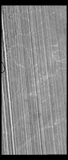
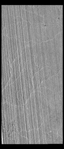
10 Artifacts in PALSAR Images along an ALOS Path over South America ~60 km 10

 15-min ROTI maps IPP at 400 km ALT Grid resolution: 3.75 x 2.")
11 Supporting Studies of Ionospheric Impact on Spaceborne InSAR Imagery PALSAR Imagery Phased Array type L-band Synthetic Aperture Radar InSAR images affected by ionospheric irregularities and scintillation, shown as artifacts in radar images Regional Map of Ionospheric Irregularities and Scintillation (RMIIS) Ground-based GPS receiver networks (31 stations) 15-min ROTI maps IPP at 400 km ALT Grid resolution: 3.75 x 2.5 ( LON x LAT) [Ref#3, 2012] ALOS Path 11


12 Impact of Scintillation on Positioning Quiet [Ref#4, 2013] Storm 12
13 Summary Dual-frequency GPS phase data collected from existing GNSS networks have been used to derive ROT and ROTI measurements Analyses by various groups have shown that ROTI is a good occurrence indicator for L-band amplitude and phase scintillation, though their magnitudes can be different depending on plasma physics processes and radio propagation environment in different latitude regions ROTI maps have been applied to monitoring global and regional activities of ionospheric irregularities with a 15-min temporal resolution continuously A significant event of irregularities and phase scintillation occurred in most of the contiguous United States and Alaska under space weather disturbances has been recorded using ROTI maps The GPS-based ionospheric irregularity measurements have been applied to various studies, including the impact of ionospheric scintillation on Earth science remote sensing imagery and GPS-based positioning Real-time ROTI maps have been tested at JPL, and U.S. regional real-time ROTI maps will soon be made available to the public to serve space weather monitoring and prediction 13
14 References 1. Pi, X., A. J. Mannucci, U. J. Lindquister, and C. M. Ho, Monitoring of global ionospheric irregularities using the worldwide GPS network, Geophys. Res. Lett, Vol.24, No.18, pp , Pi, X., A. Freeman, B. Chapman, P. Rosen, and Z. Li (2011), Imaging ionospheric inhomogeneities using spaceborne synthetic aperture radar, J. Geophys. Res., 116, A04303, doi: /2010ja Xiaoqing Pi, Franz J. Meyer, Kancham Chotoo, Anthony Freeman, Ronald G. Caton, and Christopher T. Bridgwood, Impact of Ionospheric Scintillation on Spaceborne SAR Observations Studied Using GNSS, ION GNSS, pp , Xiaoqing Pi, Anthony J. Mannucci, Bonnie Valant-Spaight, Yoaz Bar-Sever, Larry J. Romans, Susan Skone, Lawrence Sparks, and G. Martin Hall, Observations of Global and Regional Ionospheric Irregularities and Scintillation Using GNSS Tracking Networks, ION Pacific PNT, pp , Xiaoqing Pi, Measuring Ionospheric Irregularities globally by the Rate of TEC Index and GNSS Networks, Space Weather Workshop, Boulder, CO, April 27, Beach, T.L. and Kintner, P.M. (1999). Simultaneous Global Positioning System observations of equatorial scintillations and total electron content fluctuations. Journal of Geophysical Research 104: doi: /1999JA issn:
Study of the Ionosphere Irregularities Caused by Space Weather Activity on the Base of GNSS Measurements
 Study of the Ionosphere Irregularities Caused by Space Weather Activity on the Base of GNSS Measurements Iu. Cherniak 1, I. Zakharenkova 1,2, A. Krankowski 1 1 Space Radio Research Center,, University
Present and future IGS Ionospheric products
 Present and future IGS Ionospheric products Andrzej Krankowski, Manuel Hernández-Pajares, Joachim Feltens, Attila Komjathy, Stefan Schaer, Alberto García-Rigo, Pawel Wielgosz Outline Introduction IGS IONO
Detecting Ionospheric TEC Perturbations Generated by Natural Hazards Using a Real-Time Network of GPS Receivers
 Detecting Ionospheric TEC Perturbations Generated by Natural Hazards Using a Real-Time Network of GPS Receivers Attila Komjathy, Yu-Ming Yang, and Anthony J. Mannucci Jet Propulsion Laboratory California
A Review of Ionospheric Effects in Low-Frequency SAR Data
 A Review of Ionospheric Effects in Low-Frequency SAR Data Signals, Correction Methods, and Performance Requirements F.J Meyer 1) 2), P. Rosen, A. Freeman, K. Papathanassiou, J. Nicoll, B. Watkins, M. Eineder,
Satellite Navigation Science and Technology for Africa. 23 March - 9 April, The African Ionosphere
 2025-28 Satellite Navigation Science and Technology for Africa 23 March - 9 April, 2009 The African Ionosphere Radicella Sandro Maria Abdus Salam Intern. Centre For Theoretical Physics Aeronomy and Radiopropagation
ROTI Maps: a new IGS s ionospheric product characterizing the ionospheric irregularities occurrence
 3-7 July 2017 ROTI Maps: a new IGS s ionospheric product characterizing the ionospheric irregularities occurrence Iurii Cherniak Andrzej Krankowski Irina Zakharenkova Space Radio-Diagnostic Research Center,
RECENT ADVANCES IN THE CORRECTION OF IONOSPHERIC EFFECTS IN LOW-FREQUENCY SAR DATA
 RECENT ADVANCES IN THE CORRECTION OF IONOSPHERIC EFFECTS IN LOW-FREQUENCY SAR DATA F.J Meyer 1) 2), B. Watkins 3), J.S. Kim 4), K. Papathanassiou 4) 1)Earth & Planetary Remote Sensing, University of Alaska
LEO GPS Measurements to Study the Topside Ionospheric Irregularities
 LEO GPS Measurements to Study the Topside Ionospheric Irregularities Irina Zakharenkova and Elvira Astafyeva 1 Institut de Physique du Globe de Paris, Paris Sorbonne Cité, Univ. Paris Diderot, UMR CNRS
NAVIGATION SYSTEMS PANEL (NSP) NSP Working Group meetings. Impact of ionospheric effects on SBAS L1 operations. Montreal, Canada, October, 2006
 NSP Working Group meetings. Impact of ionospheric effects on SBAS L1 operations. Montreal, Canada, October, 2006") NAVIGATION SYSTEMS PANEL (NSP) NSP Working Group meetings Agenda Item 2b: Impact of ionospheric effects on SBAS L1 operations Montreal, Canada, October, 26 WORKING PAPER CHARACTERISATION OF IONOSPHERE
NAVIGATION SYSTEMS PANEL (NSP) NSP Working Group meetings Agenda Item 2b: Impact of ionospheric effects on SBAS L1 operations Montreal, Canada, October, 26 WORKING PAPER CHARACTERISATION OF IONOSPHERE
Automated daily processing of more than 1000 ground-based GPS receivers for studying intense ionospheric storms
 RADIO SCIENCE, VOL. 40,, doi:10.1029/2005rs003279, 2005 Automated daily processing of more than 1000 ground-based GPS receivers for studying intense ionospheric storms Attila Komjathy, Lawrence Sparks,
Measurement Of Faraday Rotation In SAR Data Using MST Radar Data
 Measurement Of Faraday Rotation In SAR Data Using MST Radar Data Fatima Kani. K, Glory. J, Kanchanadevi. P, Saranya. P PG Scholars, Department of Electronics and Communication Engineering Kumaraguru College
Sub-Mesoscale Imaging of the Ionosphere with SMAP
 Sub-Mesoscale Imaging of the Ionosphere with SMAP Tony Freeman Xiaoqing Pi Xiaoyan Zhou CEOS Workshop, ASF, Fairbanks, Alaska, December 2009 1 Soil Moisture Active-Passive (SMAP) Overview Baseline Mission
Study of small scale plasma irregularities. Đorđe Stevanović
 Study of small scale plasma irregularities in the ionosphere Đorđe Stevanović Overview 1. Global Navigation Satellite Systems 2. Space weather 3. Ionosphere and its effects 4. Case study a. Instruments
International GNSS Service Workshop 2017
 International GNSS Service Workshop 2017 The Recent Activities of CAS Ionosphere Analysis Center on GNSS Ionospheric Modeling within IGS CAS: Chinese Academy of Sciences Yunbin Yuan*, Zishen Li, Ningbo
Effects of magnetic storms on GPS signals
 Effects of magnetic storms on GPS signals Andreja Sušnik Supervisor: doc.dr. Biagio Forte Outline 1. Background - GPS system - Ionosphere 2. Ionospheric Scintillations 3. Experimental data 4. Conclusions
Ionospheric Monitoring in China. Zhen Weimin, Ou Ming
 ICG-5 WG-B, Turino Ionospheric Monitoring in China Zhen Weimin, Ou Ming October 20 th, 2010, Turino, Italy Outline 1.Introduction 2.Ionosphere monitoring in China 3.Summary 1. Introduction GNSS performance
Assessment of WAAS Correction Data in Eastern Canada
 Abstract Assessment of WAAS Correction Data in Eastern Canada Hyunho Rho and Richard B. Langley Geodetic Research Laboratory University of New Brunswick P.O. Box Fredericton, NB Canada, E3B 5A3 As part
Ionospheric Structure Imaging with ALOS PALSAR
 The Second ALOS PI Symposium Rhodes, Greece November 3 7, 008 Ionospheric Structure Imaging with ALOS PALSAR PI Number: 37 JAXA-RA PI: Jong-Sen Lee, Thomas L. Ainsworth and Kun-Shan Chen CSRSR, National
High latitude TEC fluctuations and irregularity oval during geomagnetic storms
 Earth Planets Space, 64, 521 529, 2012 High latitude TEC fluctuations and irregularity oval during geomagnetic storms I. I. Shagimuratov 1, A. Krankowski 2, I. Ephishov 1, Yu. Cherniak 1, P. Wielgosz 2,
Detection and Characterization of Traveling Ionospheric Disturbances (TIDs) with GPS and HF sensors
 with GPS and HF sensors") Ionospheric Effects Symposium 12-14 May 2015 Alexandria, VA Detection and Characterization of Traveling Ionospheric Disturbances (TIDs) with GPS and HF sensors Keith Groves, Vadym Paznukhov, Eileen MacKenzie
Ionospheric Effects Symposium 12-14 May 2015 Alexandria, VA Detection and Characterization of Traveling Ionospheric Disturbances (TIDs) with GPS and HF sensors Keith Groves, Vadym Paznukhov, Eileen MacKenzie
Monitoring the polar cap/ auroral ionosphere: Industrial applications. P. T. Jayachandran Physics Department University of New Brunswick Fredericton
 Monitoring the polar cap/ auroral ionosphere: Industrial applications P. T. Jayachandran Physics Department University of New Brunswick Fredericton Outline Ionosphere and its effects on modern and old
EFFECTS OF SCINTILLATIONS IN GNSS OPERATION
 - - EFFECTS OF SCINTILLATIONS IN GNSS OPERATION Y. Béniguel, J-P Adam IEEA, Courbevoie, France - 2 -. Introduction At altitudes above about 8 km, molecular and atomic constituents of the Earth s atmosphere
THE USE OF GPS/MET DATA FOR IONOSPHERIC STUDIES
 THE USE OF GPS/MET DATA FOR IONOSPHERIC STUDIES Christian Rocken GPS/MET Program Office University Corporation for Atmospheric Research Boulder, CO 80301 phone: (303) 497 8012, fax: (303) 449 7857, e-mail:
Space weather Application Center Ionosphere A Near-Real-Time Service Based on NTRIP Technology
 Space weather Application Center Ionosphere A Near-Real-Time Service Based on NTRIP Technology N. Jakowski, S. M. Stankov, D. Klaehn, C. Becker German Aerospace Center (DLR), Institute of Communications
Ionospheric Modeling for WADGPS at Northern Latitudes
 Ionospheric Modeling for WADGPS at Northern Latitudes Peter J. Stewart and Richard B. Langley Geodetic Research Laboratory, Department of Geodesy and Geomatics Engineering, University of New Brunswick,
Chapter 2 Analysis of Polar Ionospheric Scintillation Characteristics Based on GPS Data
 Chapter 2 Analysis of Polar Ionospheric Scintillation Characteristics Based on GPS Data Lijing Pan and Ping Yin Abstract Ionospheric scintillation is one of the important factors that affect the performance
Using the GRAIT Detrender to Study Ionospheric Bubbles / Irregularities over South America and the Caribbean
 Using the GRAIT Detrender to Study Ionospheric Bubbles / Irregularities over South America and the Caribbean (and the prospect for Southeast Asia-Pacific) Rezy Pradipta Boston College Institute for Scientific
Activities of the JPL Ionosphere Group
 Activities of the JPL Ionosphere Group On-going GIM wor Submit rapid and final GIM TEC maps for IGS combined ionosphere products FAA WAAS & SBAS analysis Error bounds for Brazilian sector, increasing availability
Analysis of equatorial ionospheric irregularities based on a two high rate GNSS station setup
 Analysis of equatorial ionospheric irregularities based on a two high rate GNSS station setup Jens Berdermann 1,Norbert Jakowski 1, Martin Kriegel 1, Hiroatsu Sato 1, Volker Wilken 1, Stefan Gewies 1,
The Atmosphere and its Effect on GNSS Systems 14 to 16 April 2008 Santiago, Chile
 Description of a Real-Time Algorithm for Detecting Ionospheric Depletions for SBAS and the Statistics of Depletions in South America During the Peak of the Current Solar Cycle The Atmosphere and its Effect
Ground based measurements of ionospheric turbulence manifestations induced by the VLF transmitter ABSTRACT
 Ground based measurements of ionospheric turbulence manifestations induced by the VLF transmitter Dmitry S. Kotik, 1 Fedor I. Vybornov, 1 Alexander V. Ryabov, 1 Alexander V. Pershin 1 and Vladimir A. Yashnov
Investigation of Scintillation Characteristics for High Latitude Phenomena
 Investigation of Scintillation Characteristics for High Latitude Phenomena S. Skone, F. Man, F. Ghafoori and R. Tiwari Department of Geomatics Engineering, Schulich School of Engineering, University of
First Measurements of Ionospheric TEC and GPS Scintillations from an Unmanned Marine Vehicle
 First Measurements of Ionospheric TEC and GPS Scintillations from an Unmanned Marine Vehicle Irfan Azeem, Geoff Crowley, and Adam Reynolds ASTRA 5777 Central Ave., Suite 221 Boulder, CO 80301 USA ABSTRACT
Ionospheric Effects on Aviation
 Ionospheric Effects on Aviation Recent experience in the observation and research of ionospheric irregularities, gradient anomalies, depletion walls, etc. in USA and Europe Stan Stankov, René Warnant,
Characterization of ionospheric disturbances and their relation to GNSS positioning errors at high latitudes
 Characterization of ionospheric disturbances and their relation to GNSS positioning errors at high latitudes Knut Stanley Jacobsen and Michael Dähnn Norwegian Mapping Authority, Norway Abstract We present
Study of GPS Scintillation during Solar Maximum at Malaysia
 1 st International Conference of Recent Trends in Information and Communication Technologies Study of GPS Scintillation during Solar Maximum at Malaysia Emad Fathi Aon 1,2*, Redhwan Qasem Shaddad 3,4,Abdul
Operational Products of the Space Weather Application Center Ionosphere (SWACI) and capabilities of their use
 and capabilities of their use") Operational Products of the Space Weather Application Center Ionosphere (SWACI) and capabilities of their use N. Jakowski, C. Borries, V. Wilken, K.D. Missling, H. Barkmann, M. M. Hoque, M. Tegler, C.
Operational Products of the Space Weather Application Center Ionosphere (SWACI) and capabilities of their use N. Jakowski, C. Borries, V. Wilken, K.D. Missling, H. Barkmann, M. M. Hoque, M. Tegler, C.
MWA Ionospheric Science Opportunities Space Weather Storms & Irregularities (location location location) John Foster MIT Haystack Observatory
 John Foster MIT Haystack Observatory") MWA Ionospheric Science Opportunities Space Weather Storms & Irregularities (location location location) John Foster MIT Haystack Observatory Storm Enhanced Density: Longitude-specific Ionospheric Redistribution
MWA Ionospheric Science Opportunities Space Weather Storms & Irregularities (location location location) John Foster MIT Haystack Observatory Storm Enhanced Density: Longitude-specific Ionospheric Redistribution
Multi-instrument observations of atmospheric gravity waves/traveling ionospheric disturbances associated with enhanced auroral activity
 Multi-instrument observations of atmospheric gravity waves/traveling ionospheric disturbances associated with enhanced auroral activity Zama Katamzi-Joseph *, Anasuya Aruliah, Kjellmar Oksavik, John Bosco
Space weather: A research grand challenge. Professor Jøran Moen (GCI-Cusp project scientist)
") Space weather: A research grand challenge Professor Jøran Moen (GCI-Cusp project scientist) Birkeland Space Weather Symposium 15 JUNE 2017 Outline: Space weather phenomena in cusp Research Grand Challenges
Space weather: A research grand challenge Professor Jøran Moen (GCI-Cusp project scientist) Birkeland Space Weather Symposium 15 JUNE 2017 Outline: Space weather phenomena in cusp Research Grand Challenges
Outline. GPS RO Overview. COSMIC Overview. COSMIC-2 Overview. Summary 9/29/16
 Bill Schreiner and UCAR/COSMIC Team UCAR COSMIC Program Observation and Analysis Opportunities Collaborating with the ICON and GOLD Missions Sept 27, 216 GPS RO Overview Outline COSMIC Overview COSMIC-2
Influence of Major Geomagnetic Storms Occurred in the Year 2011 On TEC Over Bangalore Station In India
 International Journal of Electronics and Communication Engineering. ISSN 0974-2166 Volume 6, Number 1 (2013), pp. 105-110 International Research Publication House http://www.irphouse.com Influence of Major
The Significance of GNSS for Radio Science
 Space Weather Effects on the Wide Area Augmentation System (WAAS) The Significance of GNSS for Radio Science Patricia H. Doherty Vice Chair, Commission G International Union of Radio Science www.ursi.org
An international initiative for atmospheric research at the poles
 An international initiative for atmospheric research at the poles L. Alfonsi 1, Nicolas Bergeot 2, Emilia Correia 3, Domenico Di Mauro 1, Pierre Cilliers 4, Mark Lester 5, Maria Federica Marcucci 6, Cathryn
SWIPPA Products COMMENTS
 PRODUCT SWIPPA-DLR-CNF-PRO-DAT-TEC SWIPPA-DLR-RST-PRO-MAP-TEC COMMENTS TEC : Total Electron Content Vertical Source: GNSS measurements; SWIPPA-DLR-CNF-PRO-DAT-TMP SWIPPA-DLR-RST-PRO-MAP-TMP TEC-TMP : Total
EFFECTS OF IONOSPHERIC SMALL-SCALE STRUCTURES ON GNSS
 EFFECTS OF IONOSPHERIC SMALL-SCALE STRUCTURES ON GNSS G. Wautelet, S. Lejeune, R. Warnant Royal Meteorological Institute of Belgium, Avenue Circulaire 3 B-8 Brussels (Belgium) e-mail: gilles.wautelet@oma.be
The ionosphere weather service SWACI and its capability for estimating propagation effects of transionospheric radio signals
 The ionosphere weather service SWACI and its capability or estimating propagation eects o transionospheric radio signals Norbert Jakowski Institute o Communications und Navigation German Aerospace Center
Ionospheric Imprint to LOFAR
 Ionospheric Imprint to LOFAR Norbert Jakowski Institute of Communications und Navigation German Aerospace Center Kalkhorstweg 53, D-17235 Neustrelitz, Germany LOFAR Workshop, 8/9 November 2010, Potsdam,
Determination of Regional TEC Values by GNSS Measurements, A Case Study: Central Anatolia Sample, Turkey
 Presented at the FIG Working Week 2017, May 29 - June 2, 2017 in Helsinki, Finland Determination of Regional TEC Values by GNSS Measurements, A Case Study: Central Anatolia Sample, Turkey Fuat BAŞÇİFTÇİ,
A study of the ionospheric effect on GBAS (Ground-Based Augmentation System) using the nation-wide GPS network data in Japan
 using the nation-wide GPS network data in Japan") A study of the ionospheric effect on GBAS (Ground-Based Augmentation System) using the nation-wide GPS network data in Japan Takayuki Yoshihara, Electronic Navigation Research Institute (ENRI) Naoki Fujii,
A study of the ionospheric effect on GBAS (Ground-Based Augmentation System) using the nation-wide GPS network data in Japan Takayuki Yoshihara, Electronic Navigation Research Institute (ENRI) Naoki Fujii,
Detection of ionospheric spatial and temporal gradients for ground based augmentation system applications
 Indian Journal of Radio & Space Physics Vol 45, March 2016, pp 11-19 Detection of ionospheric spatial and temporal gradients for ground based augmentation system applications Swapna Raghunath 1,$ & D Venkata
GPS=GLONASS-based TEC measurements as a contributor for space weather forecast
 Journal of Atmospheric and Solar-Terrestrial Physics 64 (2002) 729 735 www.elsevier.com/locate/jastp GPS=GLONASS-based TEC measurements as a contributor for space weather forecast N. Jakowski, S. Heise,
Data Assimilation Models for Space Weather
 Data Assimilation Models for Space Weather R.W. Schunk, L. Scherliess, D.C. Thompson, J. J. Sojka, & L. Zhu Center for Atmospheric & Space Sciences Utah State University Logan, Utah Presented at: SVECSE
Space Weather as a Global Challenge
 Space Weather as a Global Challenge IMPC DLR Neustrelitz and Expert Service Centre Ionospheric Weather (I-ESC) Dr. Juergen Drescher DLR Washington Office German Aerospace Center jd@dlr.org German Aerospace
IRI-Plas Optimization Based Ionospheric Tomography
 IRI-Plas Optimization Based Ionospheric Tomography Onur Cilibas onurcilibas@gmail.com.tr Umut Sezen usezen@hacettepe.edu.tr Feza Arikan arikan@hacettepe.edu.tr Tamara Gulyaeva IZMIRAN 142190 Troitsk Moscow
Regional ionospheric disturbances during magnetic storms. John Foster
 Regional ionospheric disturbances during magnetic storms John Foster Regional Ionospheric Disturbances John Foster MIT Haystack Observatory Regional Disturbances Meso-Scale (1000s km) Storm Enhanced Density
Weathering the Storm GNSS and the Solar Maximum Next Generation GNSS Ionospheric Scintillation and TEC Monitoring
 Weathering the Storm GNSS and the Solar Maximum Next Generation GNSS Ionospheric Scintillation and TEC Monitoring NovAtel White Paper March 2012 Overview This paper addresses the concerns caused by the
Integration of InSAR and GPS for precise deformation mapping
 Integration of InSAR and GPS for precise deformation mapping Zhenhong Li (COMET, University of Glasgow, UK) Eric J. Fielding (Jet Propulsion Laboratory, Caltech, USA) 30 November 2009 Contents Two major
Investigations of Global Space Weather with GPS
 Investigations of Global Space Weather with GPS A. J. Coster, J. Foster, F. Lind, P. Erickson MIT Haystack Observatory J. Semeter Boston University E. Yizengaw Boston College Overview Space weather can
Preliminary results from the Arecibo Heating EXperiment (HEX): From HF to GPS
: From HF to GPS") Preliminary results from the Arecibo Heating EXperiment (HEX): From HF to GPS CEDAR Workshop 2017 Keystone, Co Dr Natasha Jackson-Booth 21 st June 2017 Collaborators and Acknowledgements QinetiQ Richard
Preliminary results from the Arecibo Heating EXperiment (HEX): From HF to GPS CEDAR Workshop 2017 Keystone, Co Dr Natasha Jackson-Booth 21 st June 2017 Collaborators and Acknowledgements QinetiQ Richard
Modeling of Ionospheric Refraction of UHF Radar Signals at High Latitudes
 Modeling of Ionospheric Refraction of UHF Radar Signals at High Latitudes Brenton Watkins Geophysical Institute University of Alaska Fairbanks USA watkins@gi.alaska.edu Sergei Maurits and Anton Kulchitsky
Monitoring the Auroral Oval with GPS and Applications to WAAS
 Monitoring the Auroral Oval with GPS and Applications to WAAS Peter J. Stewart and Richard B. Langley Geodetic Research Laboratory Department of Geodesy and Geomatics Engineering University of New Brunswick
Storms in Earth s ionosphere
 Storms in Earth s ionosphere Archana Bhattacharyya Indian Institute of Geomagnetism IISF 2017, WSE Conclave; Anna University, Chennai Earth s Ionosphere Ionosphere is the region of the atmosphere in which
Scientific Studies of the High-Latitude Ionosphere with the Ionosphere Dynamics and ElectroDynamics - Data Assimilation (IDED-DA) Model
 Model") DISTRIBUTION STATEMENT A. Approved for public release; distribution is unlimited. Scientific Studies of the High-Latitude Ionosphere with the Ionosphere Dynamics and ElectroDynamics - Data Assimilation
DISTRIBUTION STATEMENT A. Approved for public release; distribution is unlimited. Scientific Studies of the High-Latitude Ionosphere with the Ionosphere Dynamics and ElectroDynamics - Data Assimilation
Polar Ionospheric Imaging at Storm Time
 Ms Ping Yin and Dr Cathryn Mitchell Department of Electronic and Electrical Engineering University of Bath BA2 7AY UNITED KINGDOM p.yin@bath.ac.uk / eescnm@bath.ac.uk Dr Gary Bust ARL University of Texas
Special Thanks: M. Magoun, M. Moldwin, E. Zesta, C. Valladares, and AMBER, SCINDA, & C/NOFS teams
 Longitudinal Variability of Equatorial Electrodynamics E. Yizengaw 1, J. Retterer 1, B. Carter 1, K. Groves 1, and R. Caton 2 1 Institute for Scientific Research, Boston College 2 AFRL, Kirtland AFB, NM,
Space weather forecasting with a Multimodel Ensemble Prediction System (MEPS)
") PUBLICATIONS RESEARCH ARTICLE Special Section: Ionospheric Effects Symposium 2015 Key Points: We created a Multimodel Ensemble Prediction System (MEPS) for Earth space based on different models The MEPS
PUBLICATIONS RESEARCH ARTICLE Special Section: Ionospheric Effects Symposium 2015 Key Points: We created a Multimodel Ensemble Prediction System (MEPS) for Earth space based on different models The MEPS
The USU-GAIM Data Assimilation Models for Ionospheric Specifications and Forecasts
 The USU-GAIM Data Assimilation Models for Ionospheric Specifications and Forecasts L. Scherliess, R. W. Schunk, L. C. Gardner, L. Zhu, J.V. Eccles and J.J Sojka Center for Atmospheric and Space Sciences
Recent progress of NICT ionospheric observations in Japan
 Recent progress of NICT ionospheric observations in Japan T. Tsugawa, M. Nishioka, H. Kato, H. Jin, and M. Ishii National Institute of Information and Communications Technology (NICT), Japan NICT ionospheric
MEETING OF THE METEOROLOGY PANEL (METP) METEOROLOGICAL INFORMATION AND SERVICE DEVELOPMENT WORKING GROUP (WG-MISD)
 METEOROLOGICAL INFORMATION AND SERVICE DEVELOPMENT WORKING GROUP (WG-MISD)") METP-WG/MISD/1-IP/09 12/11/15 MEETING OF THE METEOROLOGY PANEL (METP) METEOROLOGICAL INFORMATION AND SERVICE DEVELOPMENT WORKING GROUP (WG-MISD) FIRST MEETING Washington DC, United States, 16 to 19 November
METP-WG/MISD/1-IP/09 12/11/15 MEETING OF THE METEOROLOGY PANEL (METP) METEOROLOGICAL INFORMATION AND SERVICE DEVELOPMENT WORKING GROUP (WG-MISD) FIRST MEETING Washington DC, United States, 16 to 19 November
Daily and seasonal variations of TID parameters over the Antarctic Peninsula
 Daily and seasonal variations of TID parameters over the Antarctic Peninsula A. Zalizovski 1, Y. Yampolski 1, V. Paznukhov 2, E. Mishin 3, A. Sopin 1 1. Institute of Radio Astronomy, National Academy of
IES 2015, May 12-14, Old Town Alexandria. Geomagnetic Laboratory, Natural Resources Canada 2. Geodetic Survey, Natural Resources Canada
 Analyses of the geomagnetic variations and GPS scintillation over the Canadian auroral zone Lidia Nikitina 1, D.W. Danskin 1, R. Ghoddousi-Fard 2, P. Prikryl 1 1 Geomagnetic Laboratory, Natural Resources
The impact of geomagnetic substorms on GPS receiver performance
 LETTER Earth Planets Space, 52, 1067 1071, 2000 The impact of geomagnetic substorms on GPS receiver performance S. Skone and M. de Jong Department of Geomatics Engineering, University of Calgary, 2500
Report of Regional Warning Centre INDIA, Annual Report
 Report of Regional Warning Centre INDIA, 2013-2014 Annual Report A.K Upadhayaya Radio and Atmospheric Sciences Division, National Physical Laboratory, New Delhi-110012, India Email: upadhayayaak@nplindia.org
CNTEC: A regional ionospheric TEC mapping technique over China and adjacent areas
 CNTEC: A regional ionospheric TEC mapping technique over China and adjacent areas Ercha Aa, Wengeng Huang, Yanhong Chen, and Hua Shen National Space Science Center, Chinese Academy of Sciences Outline
The GPS measured SITEC caused by the very intense solar flare on July 14, 2000
 Advances in Space Research 36 (2005) 2465 2469 www.elsevier.com/locate/asr The GPS measured SITEC caused by the very intense solar flare on July 14, 2000 Weixing Wan a, *, Libo Liu a, Hong Yuan b, Baiqi
SPACE WEATHER EFFECTS IN THE IONOSPHERE AND THEIR IMPACT ON POSITIONING
 SPACE WEATHER EFFECTS IN THE IONOSPHERE AND THEIR IMPACT ON POSITIONING N. Jakowski, A. Wehrenpfennig, S. Heise, S. Schlüter, and T. Noack Deutsches Zentrum für Luft- und Raumfahrt (DLR), Institut für
Total Electron Content (TEC) and Model Validation at an Equatorial Region
 and Model Validation at an Equatorial Region") Total Electron Content (TEC) and Model Validation at an Equatorial Region NORSUZILA YA ACOB 1, MARDINA ABDULLAH 2,* MAHAMOD ISMAIL 2,* AND AZAMI ZAHARIM 3,** 1 Faculty of Electrical Engineering, Universiti
Total Electron Content (TEC) and Model Validation at an Equatorial Region NORSUZILA YA ACOB 1, MARDINA ABDULLAH 2,* MAHAMOD ISMAIL 2,* AND AZAMI ZAHARIM 3,** 1 Faculty of Electrical Engineering, Universiti
An Investigation of Local-Scale Spatial Gradient of Ionospheric Delay Using the Nation-Wide GPS Network Data in Japan
 An Investigation of Local-Scale Spatial Gradient of Ionospheric Delay Using the Nation-Wide GPS Network Data in Japan Takayuki Yoshihara, Takeyasu Sakai and Naoki Fujii, Electronic Navigation Research
Space Weather influence on satellite based navigation and precise positioning
 Space Weather influence on satellite based navigation and precise positioning R. Warnant, S. Lejeune, M. Bavier Royal Observatory of Belgium Avenue Circulaire, 3 B-1180 Brussels (Belgium) What this talk
Climatology of ionospheric scintillation over the Vietnam low-latitude region for the period
 Climatology of ionospheric scintillation over the Vietnam low-latitude region for the period 2006-2014 Tran Thi Lan, Le Huy Minh, C. Amory-Mazaudier, R. Fleury To cite this version: Tran Thi Lan, Le Huy
Atmospheric Investigations for WAAS
 UNB - Nav Canada Atmospheric Investigations for WAAS Ionosphere Peter Stewart and Richard Langley Presentation to the Ionospheric Working Group Denver, Colorado June 3rd, 1998 Introduction Nav Canada contract
Ionospheric Propagation Effects on W de Bandwidth Sig Si nals Dennis L. Knepp NorthWest Research NorthW Associates est Research Monterey California
 Ionospheric Propagation Effects on Wide Bandwidth Signals Dennis L. Knepp NorthWest Research Associates 2008 URSI General Assembly Chicago, August 2008 Ionospheric Effects on Propagating Signals Mean effects:
Space Weather and the Ionosphere
 Dynamic Positioning Conference October 17-18, 2000 Sensors Space Weather and the Ionosphere Grant Marshall Trimble Navigation, Inc. Note: Use the Page Down key to view this presentation correctly Space
[titlelscientific Studies of the High-Latitude Ionosphere with the Ionosphere Dynamics and Electrodynamics-Data Assimilation (IDED-DA) Model
 Model") [titlelscientific Studies of the High-Latitude Ionosphere with the Ionosphere Dynamics and Electrodynamics-Data Assimilation (IDED-DA) Model [awardnumberl]n00014-13-l-0267 [awardnumber2] [awardnumbermore]
[titlelscientific Studies of the High-Latitude Ionosphere with the Ionosphere Dynamics and Electrodynamics-Data Assimilation (IDED-DA) Model [awardnumberl]n00014-13-l-0267 [awardnumber2] [awardnumbermore]
Assimilation Ionosphere Model
 Assimilation Ionosphere Model Robert W. Schunk Space Environment Corporation 399 North Main, Suite 325 Logan, UT 84321 phone: (435) 752-6567 fax: (435) 752-6687 email: schunk@spacenv.com Award #: N00014-98-C-0085
Earthquake Analysis over the Equatorial
 Earthquake Analysis over the Equatorial Region by Using the Critical Frequency Data and Geomagnetic Index Earthquake Analysis over the Equatorial Region by Using the Critical Frequency Data and Geomagnetic
GNSS IONOSPHERIC SCINTILLATION STUDIES IN SINGAPORE DHIMAS SENTANU MURTI SCHOOL OF ELECTRICAL AND ELECTRONIC ENGINEERING
 GNSS IONOSPHERIC SCINTILLATION STUDIES IN SINGAPORE DHIMAS SENTANU MURTI SCHOOL OF ELECTRICAL AND ELECTRONIC ENGINEERING 2015 GNSS IONOSPHERIC SCINTILLATION STUDIES IN SINGAPORE DHIMAS SENTANU MURTI SCHOOL
Ionospheric Corrections for GNSS
 Ionospheric Corrections for GNSS The Atmosphere and its Effect on GNSS Systems 14 to 16 April 2008 Santiago, Chile Ing. Roland Lejeune Overview Ionospheric delay corrections Core constellations GPS GALILEO
Attenuation of GPS scintillation in Brazil due to magnetic storms
 SPACE WEATHER, VOL. 6,, doi:10.1029/2006sw000285, 2008 Attenuation of GPS scintillation in Brazil due to magnetic storms E. Bonelli 1 Received 21 September 2006; revised 15 June 2008; accepted 16 June
3D electron density estimation in the ionosphere by using IRI-Plas model and GPS-TEC measurements
 3D electron density estimation in the ionosphere by using IRI-Plas model and GPS-TEC measurements HAKAN TUNA, ORHAN ARIKAN, FEZA ARIKAN Bilkent University, Ankara, Turkey htuna@bilkent.edu.tr, oarikan@ee.bilkent.edu.tr
RELATIONS BETWEEN THE EQUATORIAL VERTICAL DRIFTS, ELECTROJET, GPS-TEC AND SCINTILLATION DURING THE SOLAR MINIMUM
 RELATIONS BETWEEN THE EQUATORIAL VERTICAL DRIFTS, ELECTROJET, GPS-TEC AND SCINTILLATION DURING THE 2008-09 SOLAR MINIMUM Sovit Khadka 1, 2, Cesar Valladares 2, Rezy Pradipta 2, Edgardo Pacheco 3, and Percy
Study of the Ionospheric TEC Rate in Hong Kong Region
 Study of the Ionospheric TEC Rate in Hong Kong Region and its GPS/GNSS Application LIU Zhizhao, WU Chen Dept of Land Surveying & Geo-Informatics, the Hong Kong Polytechnic University, Hung Hom, Kowloon,
1. Terrestrial propagation
 Rec. ITU-R P.844-1 1 RECOMMENDATION ITU-R P.844-1 * IONOSPHERIC FACTORS AFFECTING FREQUENCY SHARING IN THE VHF AND UHF BANDS (30 MHz-3 GHz) (Question ITU-R 218/3) (1992-1994) Rec. ITU-R PI.844-1 The ITU
Monitoring the Ionosphere and Neutral Atmosphere with GPS
 Monitoring the Ionosphere and Neutral Atmosphere with GPS Richard B. Langley Geodetic Research Laboratory Department of Geodesy and Geomatics Engineering University of New Brunswick Fredericton, N.B. Division
ELECTROMAGNETIC PROPAGATION (ALT, TEC)
") ELECTROMAGNETIC PROPAGATION (ALT, TEC) N. Picot CNES, 18 Av Ed Belin, 31401 Toulouse, France Email : Nicolas.Picot@cnes.fr ABSTRACT For electromagnetic propagation, the ionosphere plays a key role. This
ELECTROMAGNETIC PROPAGATION (ALT, TEC) N. Picot CNES, 18 Av Ed Belin, 31401 Toulouse, France Email : Nicolas.Picot@cnes.fr ABSTRACT For electromagnetic propagation, the ionosphere plays a key role. This
Introduction to International Space Weather Initiative (ISWI) and China's Participation (Meridian Project)
 and China's Participation (Meridian Project)") Introduction to International Space Weather Initiative (ISWI) and China's Participation (Meridian Project) Chi Wang National Space Science Center, CAS Nov. 7, 2012 Outline What is Space Weather? International
Introduction to International Space Weather Initiative (ISWI) and China's Participation (Meridian Project) Chi Wang National Space Science Center, CAS Nov. 7, 2012 Outline What is Space Weather? International
Analysis and Modeling of Mid-Latitude Decameter-Scale Plasma Wave Irregularities Utilizing GPS and Radar Observations
 Analysis and Modeling of Mid-Latitude Decameter-Scale Plasma Wave Irregularities Utilizing GPS and Radar Observations A. Eltrass 1, W. A. Scales 1, P. J. Erickson 2, J. M. Ruohoniemi 1, J. B. H. Baker
Extreme solar EUV flares and ICMEs and resultant extreme ionospheric effects: Comparison of the Halloween 2003 and the Bastille Day events
 RADIO SCIENCE, VOL. 41,, doi:10.1029/2005rs003331, 2006 Extreme solar EUV flares and ICMEs and resultant extreme ionospheric effects: Comparison of the Halloween 2003 and the Bastille Day events B. T.
Estimation of Rain attenuation and Ionospheric delay at a Low-Latitude Indian Station
 Estimation of Rain attenuation and Ionospheric delay at a Low-Latitude Indian Station Amita Gaur 1, Som Kumar Sharma 2 1 Vellore Institute of Technology, Vellore, India 2 Physical Research Laboratory,