GNSS Surveying & Processing (A Surveyors Peek Behind the Curtain) Presented by Jeff Clark, PLS
|
|
|
- Arnold Atkins
- 5 years ago
- Views:
Transcription
 Presented by Jeff Clark,")
1 GNSS Surveying & Processing (A Surveyors Peek Behind the Curtain) Presented by Jeff Clark, PLS
2 Global Positioning System (GPS) (GNSS) GPS is considered a passive system Passive in the sense that only the satellites transmit signals and the users simply receive them. Time measurement is essential in GPS surveying as distance is a function of the speed of light, an electromagnetic signal and elapsed time. Frequencies generated within an EDM can be used to determine the elapsed travel time of its signal. Frequencies from GPS satellites do not return back to the satellites, therefore time is critical on both ends.
3 Carrier Waves & Signal Structure GPS Satellites communicate all the necessary information to a receiver through the use of codes carried to GPS receivers on two carrier waves. A Carrier wave has at least one characteristic such as phase, amplitude, or frequency that may be changedmodulated-to carry information. GPS carriers are radio waves that come from part of the L-band which includes ultrahigh frequencies from approximately 390 MHz to 1550 MHz. The two fundamental frequencies assigned to GPS are called L1 at MHz and L2 at MHz.
4 Modulated GPS Codes GPS codes are just like computer codes they are binary. Three basic codes in GPS are the precise code, or P code; the coarse/acquisition code, or C/A code; and the Navigation code. The P code is available on both L1 & L2, each satellite repeats its portion of the P code every 7 days and the entire code is renewed every 37 weeks. The C/A code is ten times slower than the P code and each satellite broadcasts a unique C/A code on its L1 frequency (and on L1 alone) being repeated every millisecond
5 The Navigation Code The navigation code has a low frequency of 50 Hz and is modulated onto both the L1 & L2 carriers. Navigation message contains GPS time, ground receivers need this info to correlate its clock with that of the satellite clocks. Satellites carry four very stable atomic clocks that are much more precise than any commercial receiver clock. Along with time the navigation code contains information that we as users needs to calculate earth-centered, earth-fixed, WGS84 coordinates of the satellite at any moment.
 Additional information received: Atmospheric correction")
6 Navigation code (cont.) Additional information received: Atmospheric correction Antispoofing GPS almanac Satellite health
7 How GPS Works GPS works in five basic logical steps The basis of GPS is triangulation from satellites To triangulate a GPS receiver measures distance using travel time of radio signals To measure travel time, GPS needs very accurate timing. Along with distance, you need to know exactly where the satellites are in space. High orbits and careful monitoring are the secret. Finally you must correct for any delays the signal experiences as it travels through the atmosphere.

8 Triangulating from Satellites Improbable as it may seem, the whole idea behind GPS is to use satellites in space as reference point for locations here on earth. By very accurately measuring our distance from three satellites we can triangulate our position anywhere on earth. Forget for a moment how our receiver measures this distance. First we will consider how distances measurements from three satellites can pinpoint you in space.

9 Triangulating from Satellites - Say we measure our distance to a second satellite and find out that it s 12,000 miles away. - That tells us that we re not only on the first sphere but we re also on a sphere that s 12,000 miles from the second satellite. Or in other words, we re somewhere on the circle where these two spheres intersect.

10 Triangulating from Satellites - If we then make a measurement from a third satellite and find that we re 13,000 miles from that one, that narrows our position down even further, the two points where the 13,000 mile sphere cuts through the circle that s the intersection of the first two spheres. - So by ranging from three satellites we can narrow our position to just two points in space.
11 Step 1 Triangulating from Satellites - To decide which one is our true location we could make a fourth measurement. But usually one of the two points is a ridiculous answer (either too far from Earth or moving at an impossible velocity) and can be rejected without a measurement. - A fourth measurement does come in handy for another reason however, and we will talk about that later.
12 Measuring Distance from a Satellite - We saw in the last section that a position is calculated from distance measurements to at least three satellites.

13 Measuring distance from a Satellite - Mathematically the whole thing boils down to a simple concept. - Velocity x Time = Distance - In the case of GPS we re measuring a radio signal so the velocity is going to be the speed of light or roughly 186,000 miles per second.
14 Measuring distance from a Satellite - Assuming we have precise clocks, how do we measure travel time? - Suppose there was a way to get both the satellite and the receiver to start playing My Old Kentucky Home at precisely 12 noon. If sound could reach us from space (which, of course, is ridiculous) then standing at the receiver we d hear two versions, one from our receiver and one from the satellite. - These two versions would be out of sync. The version coming from the satellite would be a little delayed because it had to travel more than 11,000 miles. - If we wanted to see just how delayed the satellite s version was, we could start delaying the receiver s version until they fell into perfect sync.

15 Measuring distance from a Satellite - The amount we have to shift back the receiver s version is equal to the travel time of the satellite s version. So we just multiply that time times the speed of light and BINGO we ve got our distance to the satellite. - Only instead of My Old Kentucky Home the satellites and receivers use something called a Pseudo Random Code
16 Getting perfect timing - If measuring the travel time of a radio signal is the key to GPS, then our clocks had better be darn good, because if their timing is off by just a thousandth of a second, at the speed of light, that translates into almost 200 miles of error. - On the satellite side, timing is almost perfect because they have incredibly precise atomic clocks on board. - Atomic clocks don t run on atomic energy. They get the name because they use the oscillations of a particular atom as their metronome. - But what about our receiver s here on the ground, do we have atomic clocks?.

17 Getting perfect timing - Remember that both the satellite and the receiver need to be able to precisely synchronize their pseudorandom code to make the system work. - If our receiver s needed atomic clocks the technology would be a lame duck technology. Nobody could afford it! - Luckily designers of GPS came up with a little trick that let s us get by with inferior clocks.
18 Code-Phase GPS vs. Carrier-Phase GPS - The words Code-Phase and Carrier-Phase may sound like electronic mumbo-jumbo but, in fact, they just refer to the particular signal that we use for timing measurements. Using the GPS carrier frequency can significantly improve the accuracy of GPS. - Remember that a GPS receiver determines the travel time of a signal from a satellite by comparing the pseudo random code it s generating, with an identical code in the signal from the satellite. - The receiver slides its code later and later in time until it syncs up with the satellite s code. The amount it has to slide is equal to the signal s travel time.
19 Code-Phase GPS vs. Carrier-Phase GPS - The problem is that the bits (or cycles) of the pseudo random code are so wide that even if you do get synced up there s still plenty of slop. - There-in lies the problem with code-phase GPS. It s comparing pseudo random codes that have a cycle width of almost a microsecond, and at the speed of light a microsecond is almost 300 meters of error! - Code-phase GPS isn t really that bad because receiver designs have come up with a way to make sure the signals are almost perfectly in phase. Good receiver s get within a percent or two. But that s still at least 3-6 meters of error.
20 Taking it to a higher (frequency) authority - Survey receivers beat the system by starting with the pseudo random code and then move on to measurements based on the carrier frequency for that code. This carrier frequency is much higher so its pulses are much closer together and therefore more accurate. - Lets consider the carrier frequencies of your car radio. When you tune to 94.7 on the dial you re locking on to a carrier frequency that s 94.7 MHz. - Obviously we can t hear sounds at 94 million cycles a second. The music we hear is a modulation (or change) in this carrier frequency to coincide with what the human ear can hear.
21 Take it to a higher (frequency) authority - GPS works in the same way. The pseudo random code has a bit rate of about 1 MHz but its carrier frequency has a cycle rate of over a GHz (which is 1000 times faster!) - At the speed of light the 1.57 GHz GPS signal has a wavelength of roughly twenty centimeters, so the carrier signal can act as a much more accurate reference than the pseudo random code itself. And if we can get to within one percent of perfect phase like we do with codephase receivers we d have 3 or 4 millimeter accuracy.
22 Catching the Right Wave - In essence this method is counting the exact number of carrier cycles between the satellite and the receiver. - The problem is that the carrier frequency is hard to count because it s so uniform. Every cycle looks like every other one. The pseudo random code on the other hand is intentionally complex to make it easier to know which cycle you re looking at. - So the trick with carrier-phase GPS is to use codephase techniques to get close. If the code measurement can be made accurate to say a meter, then we only have a few wavelengths of carrier to consider as we try to determine which cycle really marks the edge of our timing pulse.
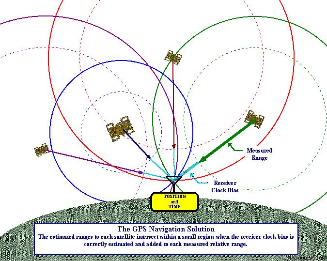
23 Getting Perfect Timing - The secret to perfect timing is to make an extra satellite measurement. - That s right, if three perfect measurements can locate a point in 3-dimensional space, then four imperfect measurements can do the same thing.

24 Getting Perfect Timing - If our receiver s clocks were perfect, then all our satellite ranges would intersect at a single point (which is our position). But with imperfect clocks, a fourth measurement, done as a cross-check, will not intersect with the first three. - So the receiver s computer says Uh-oh! there is a discrepancy in my measurements. I must not be perfectly synced with universal time.
25 Getting Perfect Timing - Since any offset from universal time will affect all measurements, the receiver looks for a single correction factor that it can subtract from all its timing measurements that would cause them all to intersect at a single point. - Once it has that correction it applies it to all the rest of its measurements and now we ve got precise positioning. - With the pseudo-random code as a rock solid timing sync pulse, and with this extra measurement trick using Carrier-Phase cycle we now have everything we need to measure our distance to a satellite in space.
26 Distance Measurement
27 Satellite Positions - So far we ve been assuming that we know where the GPS Satellites are so we can use them as reference points. - But how do we know exactly where they are? After all they re floating around 11,000 miles in space. - That 11,000 mile altitude is actually a benefit in this case, because something that high is well clear of the atmosphere. And that means it will orbit accordingly to very simple mathematics.

28 Knowing where a satellite is in space On the ground all GPS receivers have an almanac programmed into their computers that tells them where in the sky each satellite is, moment by moment. The basic orbits are quite exact but just to make things perfect the GPS satellites are constantly monitored by the Department of Defense. They use very precise radar to check each satellite s exact altitude, position and speed.
29 Knowing where a satellite is in space - The errors they re checking for are called ephemeris errors because they affect the satellite s orbit or ephemeris. These errors are caused by gravitational pulls from the moon and sun and by the pressure of solar radiation on the satellites. - The errors are usually very slight but if you want great accuracy they must be taken into account.
30 Correcting Errors - Up to now we ve been treating the calculation that go into GPS very abstractly, as if the whole thing were happening in a vacuum. But in the real world there are lots of things that can happen to a GPS signal that will make its life less than mathematically perfect. - To get the most out of the system, a good GPS receiver needs to take a wide variety of possible errors into account. Here s what they ve got to deal with. - First, one of the basic assumptions we ve been using throughout this discussion is not exactly true. We ve been saying that you calculate distance to a satellite by multiplying a signal s travel time by the speed of light. Speed of light is only constant in a vacuum.
31 Correcting Errors - As a GPS signal passes through the charged particles of the ionosphere and then through the water vapor in the Troposphere it gets slowed down a bit, and this creates the same kind of error as bad clocks. - The ionosphere is the layer of the atmosphere ranging in altitude from 50 to 500 km. - It consists largely of ionized particles which can exert a perturbing effect on GPS signals - While much of the error induced by the ionosphere can be removed through mathematical modeling, it is still one of the most significant error sources.
32 Correcting Errors - The Troposphere is the lower part of the earth s atmosphere that encompasses our weather. - It s full of water vapor and varies in temperature and pressure. - But as messy as it is, it causes relatively little error. - There are a couple of ways to minimize this kind of error. For one thing we can predict what a typical delay might be on a typical day. This is called modeling and it helps but, of course atmospheric conditions are rarely exactly typical.

33 Correcting Errors
34 Error Modeling - Much of the delay caused by a signal s trip through our atmosphere can be predicted. - Mathematical models of the atmosphere take into account the charged particles in the ionosphere and the varying gaseous content of the troposphere. - On top of that, the satellites constantly transmit updates to the basic ionospheric model. - A GPS receiver must factor in the angle each signal is taking as it enters the atmosphere because that angle determines the length of the trip through the perturbing medium.
35 Error Modeling - Another way to get a handle on these atmosphereinduced errors is to compare the relative speeds of two different signals. This dual frequency measurement is very sophisticated and is only possible with advanced receivers. - Physics says that as light moves through a given medium, low-frequency signals get refracted or slowed more than high-frequency signals. - By comparing the delays of the two different carrier frequencies of the GPS signal, L1 and L2, we can deduce what the medium (i.e. atmosphere) is, and we can correct for it.
36 Multipath Error - Trouble for the GPS signal doesn t end when it gets down to the ground. The signal may bounce off various local obstructions before it gets to our receiver. - This is called multipath error. Good receivers use sophisticated signal rejection techniques to minimize this problem. - The whole concept on GPS relies on the idea that a GPS signal flies straight from the satellite to the receiver. - Unfortunately, in the real world the signal will also bounce around on just about everything in the local environment and get to the receiver that way too. - If the bounced signals are strong enough they can confuse the receiver and cause erroneous measurements.

37 Multipath Error - Sophisticated receivers use a variety of signal processing tricks to make sure that they only consider the earliest arriving signals (which are the direct ones)

38 Correcting Errors - Even though the satellites are very sophisticated they do account for some tiny errors in the system - The atomic clocks they use are very, very precise but they re not perfect. Minute discrepancies can occur, and these translate into travel time measurement errors.
39 Correcting Errors - And even though the satellites positions are constantly monitored, they can t be watched every second. So slight position or ephemeris errors can sneak in between monitoring times. - Ephemeris (or orbital) data is constantly being transmitted by the satellites. - Receivers maintain an almanac of this data for all satellites and they update these almanacs as new data come in. - Typically, ephemeris data is updated hourly.
40 Control Stations Data to & from the satellites:

41 GNSS Surveying
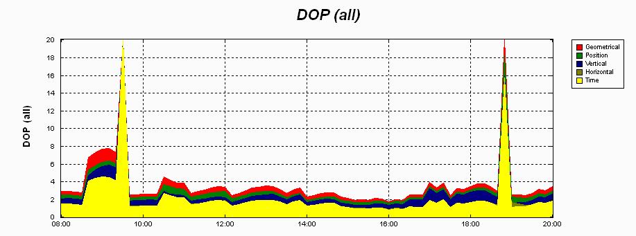
42 Uncertainty of the GPS Position (DOP) - Satellite Effects on Accuracy Distribution of the satellites above an observer s horizon has a direct bearing on the quality of the position derived from them. The accuracy of a GPS position is subject to a geometric phenomenon called dilution of precision (DOP) A Low DOP factor is good, a high DOP factor is bad. As we discussed earlier four or more satellites must be available for the simultaneous solution of the clock offset and three dimensions of the receiver s position.
43 DOP Components - HDOP Horizontal dilution of Precision - VDOP Vertical dilution of Precision - TDOP Time dilution of Precision - GDOP Geometric Dilution of Precision - RDOP Relative Dilution of Precision - PDOP Positional dilution of Precision is the combination of both the HDOP & VDOP. This value is commonly displayed during observations or can be issued in report form during processing.

44 Geometric Effects

45 Geometric Effects
46 Positional Dilution of Precision - The lowest possible value of DOP is 1. In practice, the lowest DOPS are around For example, if the standard deviation of a position were +/- 5 meters and the DOP2, then the actual uncertainty of the position would be 2 times +/- 5 meters or +/- 10 meters. - In general, one could say that the higher the DOP value there could be more uncertainty of the GPS position.
47 GPS Survey Methods Static & Fast Static Surveys - Static/Fast static data is recorded when the receiver is stationary throughout the session. - The most important distinction between Static and Fast Static is the minimum time required for the receiver to record data (the occupation time). This time depends on your application, the baseline length, and whether you are using single or dual frequency receivers. - Static occupation times can range from 30 minutes to several hours or more in length for applications requiring the highest levels of precision and repeatability.
48 GPS Survey Methods - In general, longer baselines require longer occupation times. As occupation times increase, so does the confidence in the computed result.
49 Planning a Static or Fast Static Survey Why use GPS Planning Software - Predict satellite availability at each mark - Experiment with satellite selection, almanacs, time zones, site visibility obstructions and elevation mask. - Determine the best observation periods for a given session. - Visualize satellite availability through tables and graphical representations.

50 Planning Charts & Graphs
51 Network Planning & Design - Good Network Geometry - Independent Baselines - Network Redundancy - Baseline Redundancy

52 Good or Bad Network Design
53 Independent Baselines - The use of independent baselines ensures that all data is used only once. Dependent data can introduce a bias into a data set and give erroneous results. - If a GPS session uses five receivers, the raw data produces ten possible baselines. Only four of those baselines are independent. Independent baselines must not form a closed figure. The surveyor decides which four are independent. - Trivial or dependent baselines distort network statistics. Station accuracy statistics are falsely improved. Formulas - # of Baselines = N(N-1)/2 # of Independent Baselines = N-1 Where N = # of receivers

54 Independent Baselines
55 Independent Baselines
56 Network Redundancy - Additional observations beyond the minimum required to compute coordinates for unknown points are called redundant observations. - Redundancy in field measurements: - Isolates and identifies errors - Provides network quality control checks which increases confidence in the results. Trivial baselines are not redundant observations.

57 Baseline Redundancy - Where you put redundant baselines depends on the overall goal of the survey. Choose redundant baselines to provide added confidence between points that tie: - The old network to the new network - The new network to itself - Questionable point to well established controls

58 GPS Traversing & Spur Lines
59 Baseline Solution Types - Fixed indicates that the baseline processor solved the integer ambiguities. - Float indicates that the baseline processor did not find a set of integers statistically better than any other set of integers. L1 Only solution is usually based on baselines that are less than 5 km for single & dual frequency receivers. For dual frequency data, L2 is used to help solve the integer ambiguities. Iono-Free solution uses data from both L1 and L2 signals. The Lw2 signal from the dual frequency receiver is used by the processor to determine the integer ambiguities for baselines longer than 5km.

60 Baseline Solution Types Float A float solution does not necessarily mean that the baseline solution is invalid. A float solution indicates a problem for baselines less than 5 km. For longer baselines, evaluate the baseline quality by checking the reference variance, RMS, and residual plots.
61 Statistical Analysis Tools Reference Variance a unitless number indicating how well the observed data for a baseline fit the computed solution. The processor compares the actual error to its estimated error. When the two quantities are equal, the reference variance equals 1.00, indicating the solution is statistically sound. Ratio is the relationship between the variance of the second-best candidate fixed solution to the variance of the best-candidate fixed solution generated by the processor s integer search. Higher ratios indicate larger differences between the variance of the best choice and the second-best choice. Only fixed-integer solutions have ratios, and high ratios are desired. Ratios are GPS quality indicators, not human error indicators.
62 Statistical Analysis Tools RMS another statistic that allows you to evaluate the quality of the baseline solution is the root mean square (RMS). The baseline solution is an estimate using all of the data collected in the field. The processor compares each measurement epoch to the baseline solution. Each epoch is then compared, and the differences averaged. The RMS is the average of the epoch s residuals. Values less than 15 mm (0.049 ) are acceptable for most small to medium-sized projects. Quick evaluation of baselines low reference variance (close to 1.0), high ratios no less than 1.5, RMS 15mm or less.
63 Detailed Solution Report
64 Detailed Solution Report

65 Detailed Solution Report
66 Detailed Solution Report
67 Detailed Solution Report

68 Detailed Timeline Report

69 Detailed Timeline Report
70 Loop Closures - A loop closure report is an excellent diagnostic tool for evaluating the quality of baseline solutions. Baseline loop closures are performed on the network with closed geometric figures you have selected. - A large misclosure indicates that there is a problem baseline within the loop.
71 Network Adjustment - Network adjustment brings all the data together. The adjustment applies statistical principles to identify bad observations in the network. - Network adjustment occurs in two major steps: - Minimally constrained quality control - Fully constrained computes network point coordinates. The minimally constrained adjustment: - check s the network s internal consistency - Obtains accurate error estimates - Detects bad observation
72 Minimally Constrained Adjustment Minimally constrained network:
73 Network Adjustment Errors There are two main analysis tools to help determine adjustment errors: - Reference Factor - Chi-Square Test The network reference factor compares the network as a whole. Your software may refer to the network reference factor as the standard error (or deviation) of unit weight. If observation errors have been accurately estimated, the residual added to each observation is equal to the expected error, the reference factor is 1. - A reference factor greater than 1 indicates underestimated error - A reference factor less than 1 indicates overestimated error.
74 Network Adjustment Errors What s wrong with this solution?
75 Network Weighting Strategy - Station Weighting How much error do you want to allow in the setup.
76 Network Adjustment Use of a Scalar often, the network adjustment passes only if the error estimates are multiplied or scaled by some amount.

77 Network Adjustment Minimally Constrained Adjustment is Complete!!!!
")
78 Network Adjustment What about the vertical (e) (h)?
79 Network Adjustment Fixed the elevation and readjust.
80 Network Adjustment Settings Remember Set-Up Errors!

81 Network Adjustment Reports Adjusted Grid Coordinates
82 Network Adjustment Reports Error Ellipse Components
83 Fully Constrained Adjustment The Fully Constrained Adjustment - Transforms the network to the control obtained during the network design - Checks that the existing control fits together well - Produces a network transformation - When the minimally constrained adjustment is complete, the observations can coexist. A rigid structure is defined. The fully constrained adjustment orients this rigid structure into some real-world datum. - As control points held fixed, network transformation parameters, rotation, scale, and deflections of longitude and latitude become defined.

84 Fully Constrained Adjustment Fixing all known control in network
85 Network Adjustment Report Adjustment settings:
86 Network Adjustment Report Four Points held fixed:
GPS Tutorial Trimble Home > GPS Tutorial > How GPS works? > Triangulating
 http://www.trimble.com/gps/howgps-triangulating.shtml Page 1 of 3 Trimble Worldwide Popula PRODUCTS & SOLUTIONS SUPPORT & TRAINING ABOUT TRIMBLE INVESTORS GPS Tutorial Trimble Home > GPS Tutorial > How
CARRIER PHASE VS. CODE PHASE
 DIFFERENTIAL CORRECTION Code phase processing- GPS measurements based on the pseudo random code (C/A or P) as opposed to the carrier of that code. (1-5 meter accuracy) Carrier phase processing- GPS measurements
GLOBAL POSITIONING SYSTEMS. Knowing where and when
 GLOBAL POSITIONING SYSTEMS Knowing where and when Overview Continuous position fixes Worldwide coverage Latitude/Longitude/Height Centimeter accuracy Accurate time Feasibility studies begun in 1960 s.
PRINCIPLES AND FUNCTIONING OF GPS/ DGPS /ETS ER A. K. ATABUDHI, ORSAC
 PRINCIPLES AND FUNCTIONING OF GPS/ DGPS /ETS ER A. K. ATABUDHI, ORSAC GPS GPS, which stands for Global Positioning System, is the only system today able to show you your exact position on the Earth anytime,
PDHonline Course L105 (12 PDH) GPS Surveying. Instructor: Jan Van Sickle, P.L.S. PDH Online PDH Center
 GPS Surveying. Instructor: Jan Van Sickle, P.L.S. PDH Online PDH Center") PDHonline Course L105 (12 PDH) GPS Surveying Instructor: Jan Van Sickle, P.L.S. 2012 PDH Online PDH Center 5272 Meadow Estates Drive Fairfax, VA 22030-6658 Phone & Fax: 703-988-0088 www.pdhonline.org www.pdhcenter.com
PDHonline Course L105 (12 PDH) GPS Surveying Instructor: Jan Van Sickle, P.L.S. 2012 PDH Online PDH Center 5272 Meadow Estates Drive Fairfax, VA 22030-6658 Phone & Fax: 703-988-0088 www.pdhonline.org www.pdhcenter.com
UNIT 1 - introduction to GPS
 UNIT 1 - introduction to GPS 1. GPS SIGNAL Each GPS satellite transmit two signal for positioning purposes: L1 signal (carrier frequency of 1,575.42 MHz). Modulated onto the L1 carrier are two pseudorandom
Errors in GPS. Errors in GPS. Geodetic Co-ordinate system. R. Khosla Fall Semester
 Errors in GPS Errors in GPS GPS is currently the most accurate positioning system available globally. Although we are talking about extreme precision and measuring distances by speed of light, yet there
FieldGenius Technical Notes GPS Terminology
 FieldGenius Technical Notes GPS Terminology Almanac A set of Keplerian orbital parameters which allow the satellite positions to be predicted into the future. Ambiguity An integer value of the number of
Chapter 6 GPS Relative Positioning Determination Concepts
 Chapter 6 GPS Relative Positioning Determination Concepts 6-1. General Absolute positioning, as discussed earlier, will not provide the accuracies needed for most USACE control projects due to existing
Global Positioning Systems -GPS
 Global Positioning Systems -GPS GPS Why? What is it? How does it work? Differential GPS How can it help me? GPS Why?? Where am I? How do I get there? Where are you, and how do I get to You? WHO CARES???
PDHonline Course L105 (12 PDH) GPS Surveying. Instructor: Jan Van Sickle, P.L.S. PDH Online PDH Center
 GPS Surveying. Instructor: Jan Van Sickle, P.L.S. PDH Online PDH Center") PDHonline Course L105 (12 PDH) GPS Surveying Instructor: Jan Van Sickle, P.L.S. 2012 PDH Online PDH Center 5272 Meadow Estates Drive Fairfax, VA 22030-6658 Phone & Fax: 703-988-0088 www.pdhonline.org www.pdhcenter.com
PDHonline Course L105 (12 PDH) GPS Surveying Instructor: Jan Van Sickle, P.L.S. 2012 PDH Online PDH Center 5272 Meadow Estates Drive Fairfax, VA 22030-6658 Phone & Fax: 703-988-0088 www.pdhonline.org www.pdhcenter.com
Global Positioning Systems - GPS
 Global Positioning Systems - GPS GPS Why? What is it? How does it work? Differential GPS How can it help me? GPS Why?? Where am I? How do I get there? Where are you, and how do I get to You? WHO CARES???
Global Positioning System: what it is and how we use it for measuring the earth s movement. May 5, 2009
 Global Positioning System: what it is and how we use it for measuring the earth s movement. May 5, 2009 References Lectures from K. Larson s Introduction to GNSS http://www.colorado.edu/engineering/asen/
Fundamentals of GPS Navigation
 Fundamentals of GPS Navigation Kiril Alexiev 1 /76 2 /76 At the traditional January media briefing in Paris (January 18, 2017), European Space Agency (ESA) General Director Jan Woerner explained the knowns
The Global Positioning System
 The Global Positioning System 5-1 US GPS Facts of Note DoD navigation system First launch on 22 Feb 1978, fully operational in 1994 ~$15 billion (?) invested to date 24 (+/-) Earth-orbiting satellites
GPS Milestones, cont. GPS Milestones. The Global Positioning Sytem, Part 1 10/10/2017. M. Helper, GEO 327G/386G, UT Austin 1. US GPS Facts of Note
 The Global Positioning System US GPS Facts of Note DoD navigation system First launch on 22 Feb 1978, fully operational in 1994 ~$15 billion (?) invested to date 24 (+/-) Earth-orbiting satellites (SVs)
What is a GPS How does GPS work? GPS Segments GPS P osition Position Position Accuracy Accuracy Accuracy GPS A pplications Applications Applications
 What is GPS? What is a GPS How does GPS work? GPS Segments GPS Position Accuracy GPS Applications What is GPS? The Global Positioning System (GPS) is a precise worldwide radio-navigation system, and consists
GPS Error and Biases
 Component-I(A) - Personal Details Role Name Affiliation Principal Investigator Prof.MasoodAhsanSiddiqui Department of Geography, JamiaMilliaIslamia, New Delhi Paper Coordinator, if any Dr. Mahaveer Punia
GPS and Recent Alternatives for Localisation. Dr. Thierry Peynot Australian Centre for Field Robotics The University of Sydney
 GPS and Recent Alternatives for Localisation Dr. Thierry Peynot Australian Centre for Field Robotics The University of Sydney Global Positioning System (GPS) All-weather and continuous signal system designed
Global Navigation Satellite Systems II
 Global Navigation Satellite Systems II AERO4701 Space Engineering 3 Week 4 Last Week Examined the problem of satellite coverage and constellation design Looked at the GPS satellite constellation Overview
Resection. We can measure direction in the real world! Lecture 10: Position Determination. Resection Example: Isola, Slovenia. Professor Keith Clarke
 Geography 12: Maps and Spatial Reasoning Lecture 10: Position Determination We can measure direction in the real world! Professor Keith Clarke Resection Resection Example: Isola, Slovenia Back azimuth
Table of Contents. Frequently Used Abbreviation... xvii
 GPS Satellite Surveying, 2 nd Edition Alfred Leick Department of Surveying Engineering, University of Maine John Wiley & Sons, Inc. 1995 (Navtech order #1028) Table of Contents Preface... xiii Frequently
Digital Land Surveying and Mapping (DLS and M) Dr. Jayanta Kumar Ghosh Department of Civil Engineering Indian Institute of Technology, Roorkee
 Dr. Jayanta Kumar Ghosh Department of Civil Engineering Indian Institute of Technology, Roorkee") Digital Land Surveying and Mapping (DLS and M) Dr. Jayanta Kumar Ghosh Department of Civil Engineering Indian Institute of Technology, Roorkee Lecture 11 Errors in GPS Observables Welcome students. Lesson
Digital Land Surveying and Mapping (DLS and M) Dr. Jayanta Kumar Ghosh Department of Civil Engineering Indian Institute of Technology, Roorkee Lecture 11 Errors in GPS Observables Welcome students. Lesson
Trimble Business Center:
 Trimble Business Center: Modernized Approaches for GNSS Baseline Processing Trimble s industry-leading software includes a new dedicated processor for static baselines. The software features dynamic selection
NR402 GIS Applications in Natural Resources
 NR402 GIS Applications in Natural Resources Lesson 5 GPS/GIS integration Global Positioning System (GPS)..a global navigation system that everyone can use What is GPS? How does it work? How accurate is
GPS Errors. Figure 1. Four satellites are required to determine a GPS position.
 Expl ai ni nggps:thegl obalposi t i oni ngsyst em since a minimum of four satellites is required to calculate a position (Fig 1). However, many newer GPS receivers are equipped to receive up to 12 satellite
Sources of Geographic Information
 Sources of Geographic Information Data properties: Spatial data, i.e. data that are associated with geographic locations Data format: digital (analog data for traditional paper maps) Data Inputs: sampled
Entity Tracking and Surveillance using the Modified Biometric System, GPS-3
 Advance in Electronic and Electric Engineering. ISSN 2231-1297, Volume 3, Number 9 (2013), pp. 1115-1120 Research India Publications http://www.ripublication.com/aeee.htm Entity Tracking and Surveillance
What is it? History. Other systems. How does it work? Trilateration GEOG 201 4/28/2010. Instructor: Pesses 1. {06} The Global Positioning System
 What is it? {06} The Global Positioning System G.P.S. = Global Positioning System Different from G.I.S. (Geographic Information Systems) Map Interpretation & GPS Spring 2010 M. Pesses History Conceived
CHAPTER 2 GPS GEODESY. Estelar. The science of geodesy is concerned with the earth by quantitatively
 CHAPTER 2 GPS GEODESY 2.1. INTRODUCTION The science of geodesy is concerned with the earth by quantitatively describing the coordinates of each point on the surface in a global or local coordinate system.
GPS for. Land Surveyors. Jan Van Sickle. Fourth Edition. CRC Press. Taylor & Francis Group. Taylor & Francis Croup, an Informa business
 GPS for Land Surveyors Fourth Edition Jan Van Sickle CRC Press Taylor & Francis Group Boca Raton London New York CRC Press is an imprint of the Taylor & Francis Croup, an Informa business Contents Preface
Principles of. Principles of GPS 9/12/2011
 Principles of GPS How the Global Positioning System works is, conceptually, really very simple The GPS system is based on a distance measuring (satellite ranging) system That means that we find our position
Multipath Error Detection Using Different GPS Receiver s Antenna
 Multipath Error Detection Using Different GPS Receiver s Antenna Md. Nor KAMARUDIN and Zulkarnaini MAT AMIN, Malaysia Key words: GPS, Multipath error detection, antenna residual SUMMARY The use of satellite
Sources of Error in Satellite Navigation Positioning
 http://www.transnav.eu the International Journal on Marine Navigation and Safety of Sea Transportation Volume 11 Number 3 September 2017 DOI: 10.12716/1001.11.03.04 Sources of Error in Satellite Navigation
TEST YOUR SATELLITE NAVIGATION PERFORMANCE ON YOUR ANDROID DEVICE GLOSSARY
 TEST YOUR SATELLITE NAVIGATION PERFORMANCE ON YOUR ANDROID DEVICE GLOSSARY THE GLOSSARY This glossary aims to clarify and explain the acronyms used in GNSS and satellite navigation performance testing
The GLOBAL POSITIONING SYSTEM James R. Clynch February 2006
 The GLOBAL POSITIONING SYSTEM James R. Clynch February 2006 I. Introduction What is GPS The Global Positioning System, or GPS, is a satellite based navigation system developed by the United States Defense
Global Positioning System (GPS) Positioning Errors During Ionospheric Scintillation Event. Keywords: GPS; scintillation; positioning error
 Positioning Errors During Ionospheric Scintillation Event. Keywords: GPS; scintillation; positioning error") Jurnal Teknologi Full paper Global Positioning System (GPS) Positioning Errors During Ionospheric Scintillation Event Y. H. Ho a*, S. Abdullah b, M. H. Mokhtar b a Faculty of Electronic and Computer Engineering,
Jurnal Teknologi Full paper Global Positioning System (GPS) Positioning Errors During Ionospheric Scintillation Event Y. H. Ho a*, S. Abdullah b, M. H. Mokhtar b a Faculty of Electronic and Computer Engineering,
PDHonline Course L105 (12 PDH) GPS Surveying. Instructor: Jan Van Sickle, P.L.S. PDH Online PDH Center
 GPS Surveying. Instructor: Jan Van Sickle, P.L.S. PDH Online PDH Center") PDHonline Course L105 (12 PDH) GPS Surveying Instructor: Jan Van Sickle, P.L.S. 2012 PDH Online PDH Center 5272 Meadow Estates Drive Fairfax, VA 22030-6658 Phone & Fax: 703-988-0088 www.pdhonline.org www.pdhcenter.com
PDHonline Course L105 (12 PDH) GPS Surveying Instructor: Jan Van Sickle, P.L.S. 2012 PDH Online PDH Center 5272 Meadow Estates Drive Fairfax, VA 22030-6658 Phone & Fax: 703-988-0088 www.pdhonline.org www.pdhcenter.com
GPS Global Positioning System
 GPS Global Positioning System 10.04.2012 1 Agenda What is GPS? Basic consept History GPS receivers How they work Comunication Message format Satellite frequencies Sources of GPS signal errors 10.04.2012
Broadcast Ionospheric Model Accuracy and the Effect of Neglecting Ionospheric Effects on C/A Code Measurements on a 500 km Baseline
 Broadcast Ionospheric Model Accuracy and the Effect of Neglecting Ionospheric Effects on C/A Code Measurements on a 500 km Baseline Intro By David MacDonald Waypoint Consulting May 2002 The ionosphere
t =1 Transmitter #2 Figure 1-1 One Way Ranging Schematic
 1.0 Introduction OpenSource GPS is open source software that runs a GPS receiver based on the Zarlink GP2015 / GP2021 front end and digital processing chipset. It is a fully functional GPS receiver which
Appendix D Brief GPS Overview
 Appendix D Brief GPS Overview Global Positioning System (GPS) Theory What is GPS? The Global Positioning System (GPS) is a satellite-based navigation system, providing position information, accurate to
GPS Technical Overview N5TWP NOV08. How Can GPS Mislead
 GPS Technical Overview How Can GPS Mislead 1 Objectives Components of GPS Satellite Acquisition Process Position Determination How can GPS Mislead 2 Components of GPS Control Segment Series of monitoring
GPS Glossary Written by Carl Carter SiRF Technology 2005
 GPS Glossary Written by Carl Carter SiRF Technology 2005 This glossary provides supplementary information for students of GPS Fundamentals. While many of the terms can have other definitions from those
Primer on GPS Operations
 MP Rugged Wireless Modem Primer on GPS Operations 2130313 Rev 1.0 Cover illustration by Emma Jantz-Lee (age 11). An Introduction to GPS This primer is intended to provide the foundation for understanding
Asian Journal of Science and Technology Vol. 08, Issue, 11, pp , November, 2017 RESEARCH ARTICLE
 Available Online at http://www.journalajst.com ASIAN JOURNAL OF SCIENCE AND TECHNOLOGY ISSN: 0976-3376 Asian Journal of Science and Technology Vol. 08, Issue, 11, pp.6697-6703, November, 2017 ARTICLE INFO
GPS: The Basics. Darrell R. Dean, Jr. Civil and Environmental Engineering West Virginia University. Expected Learning Outcomes for GPS
 GPS: The Basics Darrell R. Dean, Jr. Civil and Environmental Engineering West Virginia University Expected Learning Outcomes for GPS Explain the acronym GPS Name 3 important tdt dates in history of GPS
GLOBAL POSITIONING SYSTEMS
 GLOBAL POSITIONING SYSTEMS GPS & GIS Fall 2017 Global Positioning Systems GPS is a general term for the navigation system consisting of 24-32 satellites orbiting the Earth, broadcasting data that allows
Global Positioning Systems (GPS) Trails: the achilles heel of mapping from the air / satellites
 Trails: the achilles heel of mapping from the air / satellites") Global Positioning Systems (GPS) Trails: the achilles heel of mapping from the air / satellites Google maps updated regularly by local users using GPS Also: http://openstreetmaps.org GPS applications
Global Positioning Systems (GPS) Trails: the achilles heel of mapping from the air / satellites Google maps updated regularly by local users using GPS Also: http://openstreetmaps.org GPS applications
Lecture 8: GIS Data Error & GPS Technology
 Lecture 8: GIS Data Error & GPS Technology A. Introduction We have spent the beginning of this class discussing some basic information regarding GIS technology. Now that you have a grasp of the basic terminology
Effects of magnetic storms on GPS signals
 Effects of magnetic storms on GPS signals Andreja Sušnik Supervisor: doc.dr. Biagio Forte Outline 1. Background - GPS system - Ionosphere 2. Ionospheric Scintillations 3. Experimental data 4. Conclusions
GPS STATIC-PPP POSITIONING ACCURACY VARIATION WITH OBSERVATION RECORDING INTERVAL FOR HYDROGRAPHIC APPLICATIONS (ASWAN, EGYPT)
") GPS STATIC-PPP POSITIONING ACCURACY VARIATION WITH OBSERVATION RECORDING INTERVAL FOR HYDROGRAPHIC APPLICATIONS (ASWAN, EGYPT) Ashraf Farah Associate Professor,College of Engineering, Aswan University,
GPS STATIC-PPP POSITIONING ACCURACY VARIATION WITH OBSERVATION RECORDING INTERVAL FOR HYDROGRAPHIC APPLICATIONS (ASWAN, EGYPT) Ashraf Farah Associate Professor,College of Engineering, Aswan University,
ESTIMATION OF IONOSPHERIC DELAY FOR SINGLE AND DUAL FREQUENCY GPS RECEIVERS: A COMPARISON
 ESTMATON OF ONOSPHERC DELAY FOR SNGLE AND DUAL FREQUENCY GPS RECEVERS: A COMPARSON K. Durga Rao, Dr. V B S Srilatha ndira Dutt Dept. of ECE, GTAM UNVERSTY Abstract: Global Positioning System is the emerging
Problem Areas of DGPS
 DYNAMIC POSITIONING CONFERENCE October 13 14, 1998 SENSORS Problem Areas of DGPS R. H. Prothero & G. McKenzie Racal NCS Inc. (Houston) Table of Contents 1.0 ABSTRACT... 2 2.0 A TYPICAL DGPS CONFIGURATION...
An Introduction to GPS
 An Introduction to GPS You are here The GPS system: what is GPS Principles of GPS: how does it work Processing of GPS: getting precise results Yellowstone deformation: an example What is GPS? System to
Precise Positioning with NovAtel CORRECT Including Performance Analysis
 Precise Positioning with NovAtel CORRECT Including Performance Analysis NovAtel White Paper April 2015 Overview This article provides an overview of the challenges and techniques of precise GNSS positioning.
How is GPS Used in Farming? Equipment Guidance Systems
 GPS Applications in Crop Production John Nowatzki, Extension Geospatial Specialist, Vern Hofman, Extension Ag Engineer Lowell Disrud, Assistant Professor, Kraig Nelson, Graduate Student Introduction The
On the GNSS integer ambiguity success rate
 On the GNSS integer ambiguity success rate P.J.G. Teunissen Mathematical Geodesy and Positioning Faculty of Civil Engineering and Geosciences Introduction Global Navigation Satellite System (GNSS) ambiguity
What is GPS? GPS Position Accuracy. GPS Applications. What is a GPS. How does GPS work? GPS Segments
 What is GPS? What is a GPS How does GPS work? GPS Segments GPS Position Accuracy GPS Applications 1 What is GPS? The Global Positioning System (GPS) is a precise worldwide radio-navigation system, and
Wednesday AM: (Doug) 2. PS and Long Period Signals
 2. PS and Long Period Signals") Wednesday AM: (Doug) 2 PS and Long Period Signals What is Colorado famous for? 32 satellites 12 Early on in the world of science synchronization of clocks was found to be important. consider Paris: puffs
Wednesday AM: (Doug) 2 PS and Long Period Signals What is Colorado famous for? 32 satellites 12 Early on in the world of science synchronization of clocks was found to be important. consider Paris: puffs
The global positioning system
 PHYSICS UPDATE The global positioning system Alan J Walton and Richard J Black University of Cambridge, Department of Physics, Cavendish Laboratory, Madingley Road, Cambridge CB3 0HE, UK University of
Modelling GPS Observables for Time Transfer
 Modelling GPS Observables for Time Transfer Marek Ziebart Department of Geomatic Engineering University College London Presentation structure Overview of GPS Time frames in GPS Introduction to GPS observables
APPENDIX GPS TERMINOLOGY
 APPENDIX GPS TERMINOLOGY Almanac Data transmitted by a GPS satellite which includes orbital information on all the satellites, clock correction, and atmospheric delay parameters. These data are used to
LAB PROCEDURES: TOPCON TOOLS FAMILIARIZATION
 LAB PROCEDURES: TOPCON TOOLS FAMILIARIZATION This lab will cover the basic setup and processing options of Topcon Tools (TT). We will learn how to start a project, upload data and control files, set up
Chapter 5. Clock Offset Due to Antenna Rotation
 Chapter 5. Clock Offset Due to Antenna Rotation 5. Introduction The goal of this experiment is to determine how the receiver clock offset from GPS time is affected by a rotating antenna. Because the GPS
Integration of GPS with a Rubidium Clock and a Barometer for Land Vehicle Navigation
 Integration of GPS with a Rubidium Clock and a Barometer for Land Vehicle Navigation Zhaonian Zhang, Department of Geomatics Engineering, The University of Calgary BIOGRAPHY Zhaonian Zhang is a MSc student
Modern Navigation. Thomas Herring
 12.215 Modern Navigation Thomas Herring Summary of Last class Finish up some aspects of estimation Propagation of variances for derived quantities Sequential estimation Error ellipses Discuss correlations:
ENTLN Status Update. XV International Conference on Atmospheric Electricity, June 2014, Norman, Oklahoma, U.S.A.
 ENTLN Status Update Stan Heckman 1 1 Earth Networks, Germantown, Maryland, U.S.A. ABSTRACT: Earth Networks records lightning electric field waveforms at 700 sites, and from those waveforms calculates latitudes,
Procedures for Quality Control of GNSS Surveying Results Based on Network RTK Corrections.
 Procedures for Quality Control of GNSS Surveying Results Based on Network RTK Corrections. Limin WU, China Feng xia LI, China Joël VAN CRANENBROECK, Switzerland Key words : GNSS Rover RTK operations, GNSS
GNSS & Coordinate Systems
 GNSS & Coordinate Systems Matthew McAdam, Marcelo Santos University of New Brunswick, Department of Geodesy and Geomatics Engineering, Fredericton, NB May 29, 2012 Santos, 2004 msantos@unb.ca 1 GNSS GNSS
36. Global Positioning System
 36. Introduction to the Global Positioning System (GPS) Why do we need GPS? Position: a basic need safe sea travel, crowed skies, resource management, legal questions Positioning: a challenging job local
GPS Position Estimation Using Integer Ambiguity Free Carrier Phase Measurements
 ISSN (Online) : 975-424 GPS Position Estimation Using Integer Ambiguity Free Carrier Phase Measurements G Sateesh Kumar #1, M N V S S Kumar #2, G Sasi Bhushana Rao *3 # Dept. of ECE, Aditya Institute of
MOBILE COMPUTING 1/28/18. Location, Location, Location. Overview. CSE 40814/60814 Spring 2018
 MOBILE COMPUTING CSE 40814/60814 Spring 018 Location, Location, Location Location information adds context to activity: location of sensed events in the physical world location-aware services location
GNSS 101 Bringing It Down To Earth
 GNSS 101 Bringing It Down To Earth Steve Richter Frontier Precision, Inc. UTM County Coordinates NGVD 29 State Plane Datums Scale Factors Projections Session Agenda GNSS History & Basic Theory Coordinate
GPS Basics. Introduction to GPS (Global Positioning System) Version 1.0 English
 Version 1.0 English") 20 30 40 50 GPS Basics Introduction to GPS (Global Positioning System) Version 1.0 English Contents Preface... 4 1. What is GPS and what does it do?... 5 2. System Overview... 6 2.1 The Space Segment...
20 30 40 50 GPS Basics Introduction to GPS (Global Positioning System) Version 1.0 English Contents Preface... 4 1. What is GPS and what does it do?... 5 2. System Overview... 6 2.1 The Space Segment...
RADIOMETRIC TRACKING. Space Navigation
 RADIOMETRIC TRACKING Space Navigation Space Navigation Elements SC orbit determination Knowledge and prediction of SC position & velocity SC flight path control Firing the attitude control thrusters to
2 INTRODUCTION TO GNSS REFLECTOMERY
 2 INTRODUCTION TO GNSS REFLECTOMERY 2.1 Introduction The use of Global Navigation Satellite Systems (GNSS) signals reflected by the sea surface for altimetry applications was first suggested by Martín-Neira
Automated Quality Control of Global Navigation Satellite System (GNSS) Data
 Data") P-315 Automated Quality Control of Global Navigation Satellite System (GNSS) Data S.Senthil Kumar* & Arun Kumar Chauhan, ONGC Summary Global Navigation Satellite System (GNSS), includes GPS, GLONASS and
P-315 Automated Quality Control of Global Navigation Satellite System (GNSS) Data S.Senthil Kumar* & Arun Kumar Chauhan, ONGC Summary Global Navigation Satellite System (GNSS), includes GPS, GLONASS and
AIRPORT MULTIPATH SIMULATION AND MEASUREMENT TOOL FOR SITING DGPS REFERENCE STATIONS
 AIRPORT MULTIPATH SIMULATION AND MEASUREMENT TOOL FOR SITING DGPS REFERENCE STATIONS ABSTRACT Christophe MACABIAU, Benoît ROTURIER CNS Research Laboratory of the ENAC, ENAC, 7 avenue Edouard Belin, BP
INTRODUCTION TO C-NAV S IMCA COMPLIANT QC DISPLAYS
 INTRODUCTION TO C-NAV S IMCA COMPLIANT QC DISPLAYS 730 East Kaliste Saloom Road Lafayette, Louisiana, 70508 Phone: +1 337.210.0000 Fax: +1 337.261.0192 DOCUMENT CONTROL Revision Author Revision description
ENGI 3703 Surveying and Geomatics
 Satellite Geometry: Satellites well spread out in the sky have a much stronger solution to the resection type problem (aka trilateration) then satellite that are grouped together. Since the position of
Introduction to the Global Positioning System
 GPS for ICS - 2003 Introduction to the Global Positioning System Pre-Work Pre-Work Objectives Describe at least three sources of GPS signal error, and ways to mitigate or reduce those errors. Identify
RADIO WAVE PROPAGATION
 CHAPTER 2 RADIO WAVE PROPAGATION Radio direction finding (RDF) deals with the direction of arrival of radio waves. Therefore, it is necessary to understand the basic principles involved in the propagation
Guochang Xu GPS. Theory, Algorithms and Applications. Second Edition. With 59 Figures. Sprin ger
 Guochang Xu GPS Theory, Algorithms and Applications Second Edition With 59 Figures Sprin ger Contents 1 Introduction 1 1.1 AKeyNoteofGPS 2 1.2 A Brief Message About GLONASS 3 1.3 Basic Information of Galileo
Ultra-wideband Radio Aided Carrier Phase Ambiguity Resolution in Real-Time Kinematic GPS Relative Positioning. Eric Broshears
 Ultra-wideband Radio Aided Carrier Phase Ambiguity Resolution in Real-Time Kinematic GPS Relative Positioning by Eric Broshears AthesissubmittedtotheGraduateFacultyof Auburn University in partial fulfillment
Introduction to NAVSTAR GPS
 Introduction to NAVSTAR GPS Charlie Leonard, 1999 (revised 2001, 2002) The History of GPS Feasibility studies begun in 1960 s. Pentagon appropriates funding in 1973. First satellite launched in 1978. System
Range Sensing strategies
 Range Sensing strategies Active range sensors Ultrasound Laser range sensor Slides adopted from Siegwart and Nourbakhsh 4.1.6 Range Sensors (time of flight) (1) Large range distance measurement -> called
Effect of Quasi Zenith Satellite (QZS) on GPS Positioning
 on GPS Positioning") Effect of Quasi Zenith Satellite (QZS) on GPS ing Tomoji Takasu 1, Takuji Ebinuma 2, and Akio Yasuda 3 Laboratory of Satellite Navigation, Tokyo University of Marine Science and Technology 1 (Tel: +81-5245-7365,
Effect of Quasi Zenith Satellite (QZS) on GPS ing Tomoji Takasu 1, Takuji Ebinuma 2, and Akio Yasuda 3 Laboratory of Satellite Navigation, Tokyo University of Marine Science and Technology 1 (Tel: +81-5245-7365,
Introduction to the Global Positioning System
 GPS for Fire Management - 2004 Introduction to the Global Positioning System Pre-Work Pre-Work Objectives Describe at least three sources of GPS signal error, and identify ways to mitigate or reduce those
Localization. of mobile devices. Seminar: Mobile Computing. IFW C42 Tuesday, 29th May 2001 Roger Zimmermann
 Localization of mobile devices Seminar: Mobile Computing IFW C42 Tuesday, 29th May 2001 Roger Zimmermann Overview Introduction Why Technologies Absolute Positioning Relative Positioning Selected Systems
Bernese GPS Software 4.2
 Bernese GPS Software 4.2 Introduction Signal Processing Geodetic Use Details of modules Bernese GPS Software 4.2 Highest Accuracy GPS Surveys Research and Education Big Permanent GPS arrays Commercial
Connecting a Cadastral Survey to PNG94 using GNSS
 43rd Association of Surveyors PNG Congress, Lae, 12th-15th August 2009 Connecting a Cadastral Survey to PNG94 using GNSS Richard Stanaway QUICKCLOSE Workshop overview Legal requirements to connect surveys
Chapter 13: Wave Propagation. EET-223: RF Communication Circuits Walter Lara
 Chapter 13: Wave Propagation EET-223: RF Communication Circuits Walter Lara Electrical to Electromagnetic Conversion Since the atmosphere is not a conductor of electrons (instead a good insulator), electrical
GPS: History, Operation, Processing
 GPS: History, Operation, Processing Impor tant Dates 1970 s: conceived as radionavigation system for the US military: realtime locations with few-meter accuracy. 1978: first satellite launched 1983: Declared
RADIOMETRIC TRACKING. Space Navigation
 RADIOMETRIC TRACKING Space Navigation October 24, 2016 D. Kanipe Space Navigation Elements SC orbit determination Knowledge and prediction of SC position & velocity SC flight path control Firing the attitude
CHAPTER 7 Total Station Surveying. CE 316 March 2012
 CHAPTER 7 Total Station Surveying CE 316 March 2012 249 7.1 Introduction Total station surveying - defined as the use of electronic survey equipment used to perform horizontal and vertical measurements
Sw earth Dw Direct wave GRw Ground reflected wave Sw Surface wave
 WAVE PROPAGATION By Marcel H. De Canck, ON5AU Electromagnetic radio waves can propagate in three different ways between the transmitter and the receiver. 1- Ground waves 2- Troposphere waves 3- Sky waves
ProMark 3 RTK. White Paper
 ProMark 3 RTK White Paper Table of Contents 1. Introduction... 1 2. ProMark3 RTK Operational Environment... 2 3. BLADE TM : A Unique Magellan Technology for Quicker Convergence... 3 4. ProMark3 RTK Fixed
Published in: Water Science Magazine, No. 33, 2003, April. pp PROPOSED STANDARDS AND SPECIFICATIONS FOR GPS GEODETIC SURVEYS IN EGYPT
 Published in: Water Science Magazine, No. 33, 2003, April. pp. 33-39. PROPOSED STANDARDS AND SPECIFICATIONS FOR GPS GEODETIC SURVEYS IN EGYPT By Gomaa M. Dawod Researcher, Survey Research Institute ABSTRACT
Navigation Equipment. Pilotage and Dead Reckoning. Navigational Aids. Radio Waves
 1 Navigation Equipment Successful air navigation not only involves piloting an aircraft from place to place, but also not getting lost, not breaking any FAA regulations, and not endangering the safety