Coastside Fire Protection District
|
|
|
- Cathleen Bennett
- 6 years ago
- Views:
Transcription
1 Folsom (Sacramento), CA Management Consultants Fire Station Relocation Study for the Coastside Fire Protection District Volume 1 of 2 Main Report February 19, East Bidwell St., Ste #100 Folsom, CA (916) Fax: (916)
2 TABLE OF CONTENTS Section Page VOLUME 1 of 2 Main Report (this volume) Section 1 Executive Summary...1 Section 2 Project Background and Citygate Methodology...2 General Fire Station Location Best Practices... 2 Section 3 Incident Response Statistics Key Findings...4 Section 4 Existing Geographic Coverage Models...7 Section 5 Relocation of Fire Station Coverage Models...9 Section 6 Findings and Considerations...13 Table of Tables Table 1 Percent of Each Engine s Responses by Station Area (Three Years Containing 6,961 Individual Apparatus Responses)... 4 Table 2 District Response Time Performance... 4 Table 3 Travel Time to 90% and Incident Count Inside Each Station Area (Three Years Containing 5,611 Emergent Apparatus Responses)... 5 Table 4 Travel Time to 90% and Incident Count into Other Station Areas (Three Years Containing 5,611 Emergent Apparatus Responses)... 5 Table 5 Road Mile Coverage for All Scenarios Table of Figures Figure 1 Volume of Incidents per Area over Three Years... 6 VOLUME 2 of 2 Map Atlas (separately bound) Table of Contents page i
3 SECTION 1 EXECUTIVE SUMMARY Citygate Associates, LLC was retained by the Coastside Fire Protection District (the District) to evaluate its response time coverage options for replacing its two aging fire stations in the El Granada (Station 41) and Moss Beach/Montara (Station 44) areas of the District. These two stations are older, and too small to meet District near-term needs. A recent facility assessment commissioned by the District also found that it would not be cost-effective to substantially remodel the stations. Both Stations 41 and 44 are on small parcels, in or very close to housing. Given these factors, the District asked the question: If one new station housing both fire crews could be centrally located on a new, larger parcel, could it still provide response times equivalent to the current two sites? In addition, Citygate was tasked to find the two best response time sites, should the single site prove unfeasible due to lengthened response times. Based on the analysis in this study, Citygate finds: 1. The existing District-wide response times are very good given the challenging topography and street network in this section of the coastline. 2. A single station site in the central or northern part of the District cannot provide similar response times as the two existing fire station locations to both neighborhoods. 3. A single fire station site also reduces response time overlap into adjoining fire station areas. This is needed when District units are committed to other emergencies. 4. Response times in the central and northern District can be maintained, or slightly improved, if one or both Stations 41 and 44 were to be relocated to new sites. Given the technical measures and the findings of this study, Citygate offers the following considerations to the District as it identifies final replacement parcels for Stations 41 and 44: 1. Maintain a three-station deployment model. 2. As some of the differences between site parings are very small, Citygate suggests these factors next be evaluated to narrow down the selections for final cost determination: a. Parcel size. b. Traffic access for fire trucks. c. Land cost and cost of site improvements before a station can be built. d. Impacts to neighbors. Section 1 Executive Summary page 1
4 SECTION 2 PROJECT BACKGROUND AND CITYGATE METHODOLOGY Citygate used a combination of prior incident response time history and geographic mapping (GIS) tools to measure prior response times and to project probable response times from a single or new two-station site. In these efforts, we received incident data from San Mateo County s regional fire dispatch center for a 3-year span (12/09/ /08/2013). Citygate then calibrated travel times in the GIS map model, using the District s prior incident records, by programming actual fire truck travel times over the District s unique street topography. We then set the GIS model with the District s fire unit travel time goal to show predicted coverage. Currently, the District does not have an adopted response time performance policy. In prior years, the District has benchmarked its services against the County Emergency Medical System s (EMS) requirement for the first firefighter-paramedic unit to arrive on scene in 6:59 minutes/seconds from the point of dispatch. Therefore, in this study we subtracted the District s historical crew turnout time (from the incident records) of 1:30 minute/seconds from the 6:59 goal point, and then used a travel time of 5:30 minutes/seconds to evaluate station coverage areas. Citygate met once on site with Department staff to listen to the needs of the area. Part of the day was spent touring each of the fire stations and major service areas under consideration due to location, age, and size. After the on-site meeting, the Citygate team produced a large quantity of more technical in-depth response statistics and geographic mapping views of the deployment system. This analysis helped all parties to understand how the fire station deployment system can best be updated. GENERAL FIRE STATION LOCATION BEST PRACTICES In general, fire stations should serve a 360-degree area, covering the most populated parcels in the least minutes of travel. Thus, stations should not be positioned against barriers such as freeways, rivers, or large parcels, such as industrial institutions, that block cross-city throughstreets. Further, stations should not be located in positions that require the first seconds of travel to be through open space areas, or on very narrow, congested streets. Such situations waste response time coverage, or hamper it, as the responding unit cannot clear the immediate station area quickly enough to reach the outer edges of its assigned area in an appropriate amount of time. The best station location is one just off a primary or secondary arterial roadway, where with normal traffic signal access near the station, the responding apparatus can enter a higher speed road network that feeds the smaller, more congested neighborhoods and commercial parcels. In the Coastside Fire Protection District, many of these station location best practices are impeded by the ocean on one side, the coastal hills to the inland side, and one primary north Section 2 Project Background and Citygate Methodology page 2
5 south arterial roadway. However, to the District s benefit, while the District is fairly long north to south, its resident populations are clustered in three major areas. Each of these areas Half Moon Bay, El Granada and Moss Beach/Montara currently have one fire station. Citygate used the above response time policy, as well as published best practice deployment advice from the National Fire Protection Association (NFPA), the Insurance Service Office (ISO), and the Commission on Fire Accreditation International (CFAI). The analysis was not limited to singular or simple one-size-fits-all measures and recommendations. The District s community s demand on fire and emergency medical services is significant and complex due to geography and development patterns. As such, an analysis of options needs to consider that each population cluster should, ideally, have equal access to a basic framework of response that can control common, daily emergencies without them escalating frequently to catastrophic size. This drains all of a department s response resources and causes significant human and economic loss. Section 2 Project Background and Citygate Methodology page 3
6 SECTION 3 INCIDENT RESPONSE STATISTICS KEY FINDINGS In addition to this summary level report, Citygate also delivered to the District a comprehensive analysis of prior incident types of calls, response times, and types of properties responded to. The key factors to note in this review of prior incidents are: Incidents demand by time-of-day, day-of-week, and month follow typical suburban California coastal community patterns. There are demands for service 24/7/365 in all areas, while Half Moon Bay is the busiest area. The three current fire station areas have different but significant demand: Table 1 Percent of Each Engine s Responses by Station Area (Three Years Containing 6,961 Individual Apparatus Responses) Engine Station 40 Station 41 Station 44 E % 4.53% 1.97% E % 63.80% 8.28% E % 21.28% 65.35% Regarding response times across the entire District over the 3-year study period, Citygate finds that the District does very well despite being confronted by the challenging topography and road system: Table 2 District Response Time Performance Component of Time Time in Minutes 911 Received to Arrival 7:45-8:15 Dispatch Processing 0:30 Crew Alert (Turnout) 1:20-1:35 Travel Time (Wheels Rolling) 6:30-6:50 Given that the call received to first unit arrival times in the District are at or just over the County EMS system goal, Citygate looked at only travel time performance, and found, at a travel time goal of 5:30 minutes/seconds, that 81.4 to 84.1% of the incidents received service. This result confirms that a three-fire-station site plan, with one station per population area, is delivering customer service within District expectations. This following table shows the travel time in each station area for 90% of the incidents: Section 3 Incident Response Statistics Key Findings page 4
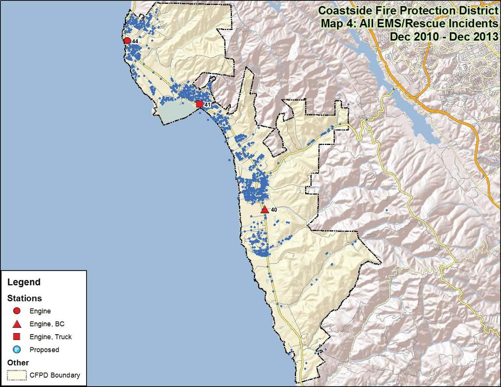
7 Table 3 Travel Time to 90% and Incident Count Inside Each Station Area (Three Years Containing 5,611 Emergent Apparatus Responses) Engine Station 40 Station 41 Station 44 E40 06:17 2,749 10: :44 33 E41 10: :13 1,225 08: E44 12: : : While the travel time in each station area, to 90% of incidents, is a little past the 5:30 minute/second goal, in Citygate s experience this is very good performance across a challenging topography and road network. Having established that response times for the primary assigned unit per area are very good, the next question becomes, What are the response times for a second-due unit, when either more firefighters are needed, or the primary unit is already committed to a prior incident? The table below shows the travel time for each unit into other station areas: Table 4 Travel Time to 90% and Incident Count into Other Station Areas (Three Years Containing 5,611 Emergent Apparatus Responses) Engine Station 40 Station 41 Station 44 E40 08: :34 12 E41 09: :40 82 E44 12: : This data shows that second-due unit performance into the most immediate adjoining station area is under 10 minutes. This, again, is very good considering the District s topography and road network. When the third-due unit has to cross into the farthest station area, the travel times are longer and approach the limit of what a rural system should be expected to deliver. If only one fire station were to serve both populated areas north of Half Moon Bay, this must be considered. if only one fire station were to serve both populated areas north of Half Moon Bay. In that event, both northern units would (depending on location) have equal travel times into all areas. Thus, the area that lost a fire station would experience increased travel times for the first-due unit. The following Google Earth map image shows, by small measurement areas, the volume of incidents per area over three years. The color indicates good response time (green) or slower response time (red). This image illustrates the data in the travel timetables above. Specifically, emergency volumes are highest in the more populated areas. Section 3 Incident Response Statistics Key Findings page 5

8 Figure 1 Volume of Incidents per Area over Three Years Section 3 Incident Response Statistics Key Findings page 6
9 SECTION 4 EXISTING GEOGRAPHIC COVERAGE MODELS To analyze first-due fire unit travel time coverage, Citygate used a geographic mapping tool, called FireView, that can measure theoretical travel time over the street network. For this portion of the study, Citygate GIS staff used the base map and posted street speed limits calibrated to actual fire company travel times from previous responses to simulate real world fire apparatus (not passenger car) coverage. Using these tools, Citygate ran several station re-location tests and measured their impact on various parts of the District. The travel time measure used was 5:30 minutes/seconds over the road network. The images are published in Volume 2 of this report, in full size, for ease of viewing small detail. The following descriptions will explain the images and the re-located fire station scenarios. The first few maps are plots of current station locations and where prior incidents have occurred across the District. This is important context because, ideally, stations should not be moved further from historical incident location patterns. Map #1 General Geography and Station Locations This view shows the existing District fire station locations within the District s boundaries. This is a reference map for the other map displays that follow. Map #2 All Incident Locations This map is an overlay of the exact location for all incident types using a 3-year data set. It is apparent that there is a need for Fire Department services on almost every street segment of the District. The greatest concentration of calls is also where the greatest concentration of Fire Department resources is available. Map #3 All Fire Type Locations This map identifies the location of all fires in the District over the previous 3 years. All fires include any type of fire call, from auto, to dumpster, to building. Obviously, there are fewer fires than medical or rescue calls. Given this, it is evident that all first-due engine districts experience fires. Map #4 EMS and Rescue Incident Locations This map further breaks out only the emergency medical and rescue call locations. Again, with the majority of the calls for service being emergency medical, virtually all areas of the District need emergency medical services. Map #5 Hot Spots for All Incident Locations Using the 3-year data set, this map examines, by mathematical density, where clusters of incident activity occurred. In this set, the darker density color plots the highest concentration of all Section 4 Existing Geographic Coverage Models page 7
10 incidents. This type of map makes the locations of frequent workload more meaningful than simply mapping the locations as done in Map #2. This perspective is important because overlap of units is critical to ensure the delivery of a good concentration of units for a multiple-apparatus response to serious emergencies. Map #6 All Fire Location Densities This map shows the hot spot activity for all fires. In this case, the call for service density is slightly more scattered, reflecting small fires, such as auto fires, in areas where the population density is lower than the urban core. Map #7 EMS and Rescue Incident Location Densities This map is similar to Map #4, but only the medical and rescue hot spots of activity are plotted. The clusters of activity look very similar to the all-incident set in Map #5 because medical calls are such a large portion of the total. Map #8 First-Due Unit Coverage at 5:30 Minutes/Seconds Engine Travel This map shows, in green colored street segments, the distribution, or first-due response time, for each station per the response goal of 5:30 minutes/seconds travel time. Therefore, the limit of color per station area is the time an engine could reach within this travel time. In lay terms, the color shows how far an engine can travel in 5:30 minutes/seconds. This map assumes responders are in-station and encounter no unusual traffic delays. Thus, the projection is optimal, or perfect-world. Real dispatch data shows response times to be a little slower in some edge areas. Most likely, this is due to the effects of the non-grid street design, and the upslope, hilly areas. The purpose of computer response mapping is to determine, and balance, station locations. This geo-mapping design is then checked in the study against actual dispatch time data. There should also be some overlap between station areas so that a second-due unit can have a chance of an adequate response time when it covers a call in another fire company s first-due area. It is not possible to serve every road segment out to the edge of the District in 5:30 travel minutes; however, these maps show that most of the District is covered to this goal point. Section 4 Existing Geographic Coverage Models page 8
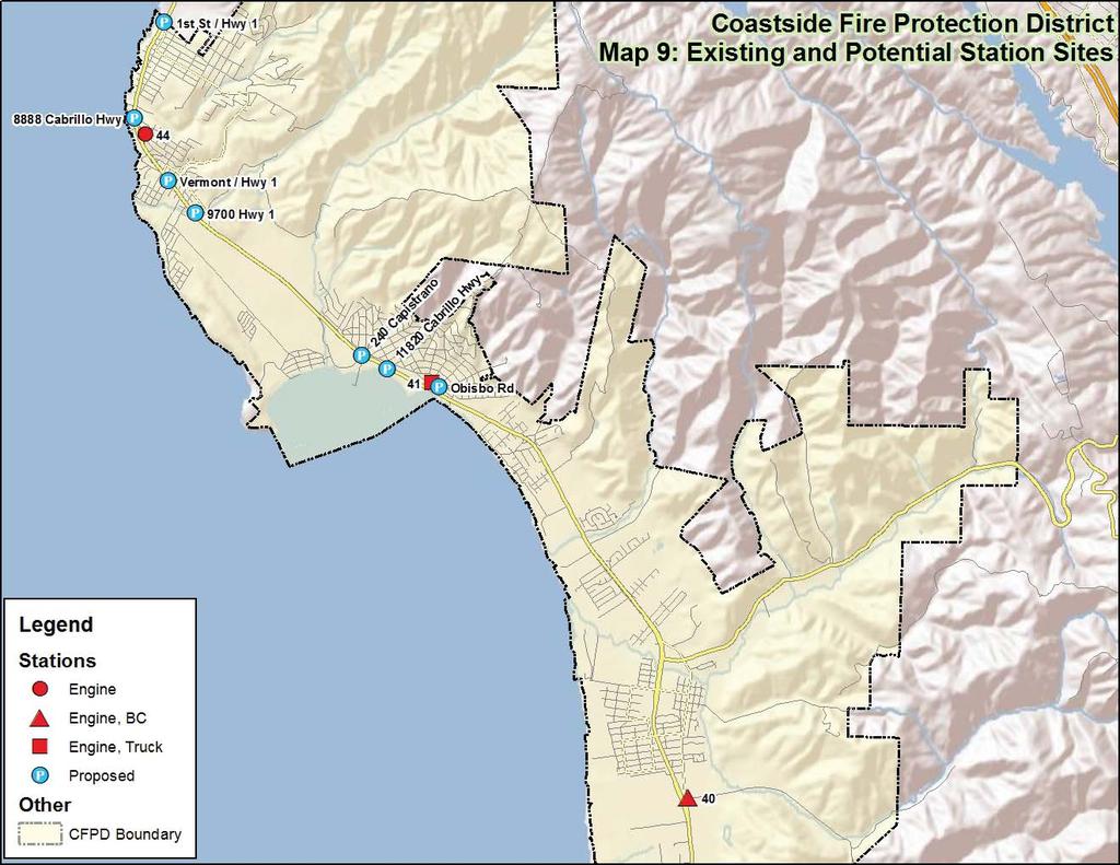
11 SECTION 5 RELOCATION OF FIRE STATION COVERAGE MODELS With an understanding of prior travel time coverage, and predicated on computer model coverage from the existing stations, Citygate then analyzed a series of test scenarios. One of the benefits of the GIS computer models is that they not only make maps to visualize coverage, but they have the ability to measure the quantity of road miles actually covered within a time measure for existing and proposed sites. This quantifies the differences between sites much better than a map. Citygate asked District staff to review local zoning and identify possible open parcels that might accommodate a fire station. That review found several vacant land sites to from which to project possible fire unit travel time. It needs to be stressed that these sites may not be for sale or survive the due diligence needed for community, District, legal, environmental, and cost acceptance. At this early test point, it is not feasible for the GIS model to find a best-fit fire station site if that site contains buildings in use, or land with zoning or environmental restrictions that would prevent the parcel from being considered. However, by starting with several vacant parcels in each neighborhood, the District leadership can determine if one or two replacement fire stations are needed, and if so, a best fit location within a few tenths of a mile in either direction. The District provided 11 alternative northern-area station locations. Given that some were on adjacent plots, some locations were plotted as a single site. Thus, Citygate tested seven sites: 240 Capistrano Cabrillo Hwy Obispo Rd (next to existing station) Vermont/Hwy Cabrillo Hwy 8888 Cabrillo Hwy 1 st St / Hwy 1 From these sites, eight scenarios were designed to test a single or various two-station moves. The GIS model calculated the as is base case comparison measure that the three existing fire stations cover to be road miles within 5:30 minutes/seconds of travel, totaling 78% of the total public, paved road miles in the District. In simpler terms, the three current fire stations can reach of the District s 158 road miles within 5:30 minutes/seconds. Citygate placed all of the road mile coverage measures by scenario into an MS-Excel spreadsheet that is sortable by different priorities. This tool, along with the map images, was given to the District so that it can continue to compare the final site choices. In the scenario descriptions below, Citygate will cite road mile coverage measures from these GIS and spreadsheet tools. Section 5 Relocation of Fire Station Coverage Models page 9
12 Map #9 Test Fire Station Locations This map view shows the existing District fire station locations along with all of the test parcel locations. The following table was taken from the MS-Excel spreadsheet and depicts road mile coverage measurements from the possible test fire station sites identified in Map #9: Table 5 Road Mile Coverage for All Scenarios Map Stations Total Road Miles (CFPD) Miles Covered Percent Loss of Road 5:30 Overlap Miles Between Proposed Location(s) and Existing Station(s) Overlap Miles Between All Locations 8 Existing Deployment: #40, #41, # % na a #40, #44, 240 Capistrano % b #40, #44, Cabrillo Hwy % c #40, #44, Obispo Rd % a #40, #41, Vermont/Hwy % b #40, #41, 9700 Hwy % c #40, #41, 8888 Cabrillo Hwy % d #40, #41, 1st St/Hwy % a #40, 1st St/Hwy 1, 240 Capistrano % b #40, 1st St/Hwy 1, Cabrillo Hwy % c #40, 1st St/Hwy 1, Obispo Rd % d #40, 8888 Cabrillo Hwy, 240 Capistrano % e #40, 8888 Cabrillo Hwy, Cabrillo Hwy % f #40, 8888 Cabrillo Hwy, Obispo Rd % g #40, Vermont/Hwy 1, 240 Capistrano % h #40, Vermont/Hwy 1, Cabrillo Hwy % i #40, Vermont/Hwy 1, Obispo Rd % j #40, 9700 Hwy 1, 240 Capistrano % k #40, 9700 Hwy 1, Cabrillo Hwy % l #40, 9700 Hwy 1, Obispo Rd % a #40, 240 Capistrano % 2 2 9b #40, Cabrillo Hwy % 4 4 9c #40, Obispo Rd % d #40, Vermont/Hwy % 0 0 9e #40, 9700 Hwy % 4 4 9f #40, 8888 Cabrillo Hwy % 0 0 9g #40, 1st St/Hwy % 0 0 Scenario #1 Maps #9a-c Merging the Two Northern Stations into One Site in Station 41 s Area This scenario tests three sites in Station 41 s area. Of sites 9a through 9c, Citygate finds that the 240 Capistrano parcel is the best fit. It has the least overlap coverage to the south, meaning it Section 5 Relocation of Fire Station Coverage Models page 10
13 does not duplicate or waste travel time coverage that Station 40 can provide. Utilizing this single location will reduce the amount of road miles covered within 5:30 minute/seconds to 102.8, a 13% reduction. Scenario #2 Maps #9d-g Merging the Two Northern Stations into One Site in Station 44 s Area This scenario tests four sites in Station 44 s area. Of sites 9a through 9c, Citygate finds that the 9700 Highway 1 parcel is the best fit. It has no overlap coverage to the south. As for road mile coverage, this single location will reduce travel time coverage the least at 5:30 minute/seconds by 12%. As a comparison, if the 1 st Street and Highway 1 site were selected, road mile coverage would reduce by 23% district-wide. Scenario #3 Maps #10a-c Using Three Fire Stations, Testing Three Sites in Station 41 s Area This scenario tests three sites in Station 41 s area. In this test, Station 44 does not move. Of sites 10a through 10c, Citygate finds that the 240 Capistrano parcel is the best fit. This location provides the same overall road mile coverage at 78%, but has the best overlap north into Station 44 s area. This means its second-due times to the north are better in case Station 44 is on a prior incident. Scenario #4 Maps #11a-d Using Three Fire Stations, Testing Four Sites in Station 44 s Area This scenario tests four sites in Station 44 s area. In this test, Station 41 does not move. Of sites 11a through 11c, Citygate finds that the Vermont and Highway 1 parcel is the best fit. This location increases overall road mile coverage to 79%, and has slight overlap south into Station 41 s area. The 1 st St and Highway 1 site is too far to the north, with very limited overlap to Station 41 s area. Scenario #5 Maps #12a-c Using Three Fire Stations, Moving Both Stations 41 and 44 In this scenario, Station 44 is relocated to 1 st Street and Highway 1 and is kept fixed as three locations are tested for Station 41. The best-fit site for Station 41 is at Cabrillo Highway, increasing road mile coverage up to 80%. This location provides overlap to the north and south. Scenario #6 Maps #12d-f Using Three Fire Stations, Moving Both Stations 41 and 44 In this scenario, Station 44 is relocated to 8888 Cabrillo Highway 1 and is kept fixed as three locations are tested for Station 41. The best-fit site for Station 41 is at Cabrillo Highway, increasing road mile coverage up to 79%. This location provides overlap to the north and south. Section 5 Relocation of Fire Station Coverage Models page 11
14 Scenario #7 Maps #12g-i Using Three Fire Stations, Moving Both Stations 41 and 44 In this scenario, Station 44 is relocated to Vermont and Highway 1 and is kept fixed as three locations are tested for Station 41. The best-fit site for Station 41 is again at Cabrillo Highway, increasing road mile coverage up to 79%. This location provides overlap to the north and south. Scenario #8 Maps #12j-l Using Three Fire Stations, Moving Both Stations 41 and 44 In this scenario, Station 44 is relocated to 9700 Highway 1 and is kept fixed as three locations are tested for Station 41. The best-fit site for Station 41 is again at Cabrillo Highway, where road mile coverage is unchanged at 78%. This location provides good overlap to the north and south station areas. Section 5 Relocation of Fire Station Coverage Models page 12
15 SECTION 6 FINDINGS AND CONSIDERATIONS Given all of the analysis in this study, along with the exhibits provided to the District, Citygate makes the following findings: 1. Merging the two northern District fire stations into one station lowers the existing neighborhood response times, which are very good. 2. Such a station consolidation also reduces overlap into adjoining areas when cover or multiple units are needed in each population cluster in the District. 3. Scenario #6, Map #12e is the best fit two-station model at: a Cabrillo Highway (Station 41 s area) b Cabrillo Highway (Station 44 s area) 4. Placing the Moss Beach replacement Station 44 at 8888 Cabrillo Highway allows it to cover all of the occupied streets to the north at 5:30 minutes/seconds travel, and provides some overlap down into Station 41 s area. Citygate values this more northern coverage over increased overlap southerly into Station 41 s area. This is due to the fact that there is no fire station to the immediate north, in Devil s Slide, to cover the northern-most neighborhoods in the District. Thus, we would start the coverage from the northern-most streets with homes and let the coverage extend as far as it can to the south, where at least another unit can come up northbound to meet it. However, the differences between some of the site parings are small, and the District will have to look at all other factors in siting a new station before it can make a final, conclusive determination. Based on our findings and our experience relocating fire stations, Citygate suggests these considerations as the District moves forward: 1. Maintain a three-station deployment model. 2. As some of the differences between site parings are very small, Citygate suggests these factors next be evaluated to narrow down the selections for final cost determination: a. Parcel size. b. Traffic access for fire trucks. c. Land cost and cost of site improvements before a station can be built. d. Impacts to neighbors. Section 6 Findings and Considerations page 13
 458-5100 Fax: (916) 983-2090")
16 Folsom (Sacramento), CA Management Consultants Fire Station Relocation Study for the Coastside Fire Protection District Volume 2 of 2 Map Atlas February 19, East Bidwell St., Ste #100 Folsom, CA (916) Fax: (916)
17
18
19
20
21
22
23
24
25
26
27
28
29
30
31
32
33
34
35
36
37
38
39
40
41
42
43
44
45
46
47
48
49
50
51
San Mateo County Fire Service POLICIES AND STANDARDS MANUAL
 Purpose: Policy: The purpose of this policy is to establish a standard procedure for the use of radio frequencies. This standard radio procedure will be used in the four geographical radio zones that currently
Designing Service Coverage and Measuring Accessibility and Serviceability
 Designing Service Coverage and Measuring Accessibility and Serviceability INFORMS Annual Meeting San Francisco, CA November 9-12, 2014 EunSu Lee, Ph.D., GISP, CPIM, CSCP Agenda Introduction Objectives
Experiences with the Use of Addressed Based Sampling in In-Person National Household Surveys
 Experiences with the Use of Addressed Based Sampling in In-Person National Household Surveys Jennifer Kali, Richard Sigman, Weijia Ren, Michael Jones Westat, 1600 Research Blvd, Rockville, MD 20850 Abstract
King Mill Lambert DRI# 2035 Henry County, Georgia
 Transportation Analysis King Mill Lambert DRI# 2035 Henry County, Georgia Prepared for: The Alter Group, Ltd. Prepared by: Kimley-Horn and Associates, Inc. Norcross, GA Kimley-Horn and Associates, Inc.
Radio Frequency Engineering Report. Proposed Raymond, ME Cellular Facility
 Radio Frequency Engineering Report Proposed, ME Cellular Facility (Site No.: 3462 ) May 12, 2010 C Squared Systems, LLC 920 Candia Road Manchester, NH 03109 Phone: (603) 657-9702 Fax: (603) 657-9707 Support@csquaredsystems.com
Lincoln County Fire and Rescue Association Standard Operating Guideline (SOG)
") Number: 113 Title: Fire Dispatch Guidelines Purpose: To provide an overview of communications guidelines for fire and rescue departments. 1. Radio Etiquette All Radio users shall comply with all pertinent
Number: 113 Title: Fire Dispatch Guidelines Purpose: To provide an overview of communications guidelines for fire and rescue departments. 1. Radio Etiquette All Radio users shall comply with all pertinent
David J. Gellner, AICP, Principal Planner
 Staff Report PLANNING DIVISION COMMUNITY & ECONOMIC DEVELOPMENT To: From: Salt Lake City Planning Commission David J. Gellner, AICP, Principal Planner - 801-535-6107 - david.gellner@slcgov.com Date: October
PROJECT NARRATIVE AND ALTERNATIVE ANALYSIS
 PROJECT NARRATIVE AND ALTERNATIVE ANALYSIS 15505 Sand Canyon Avenue Building D-1 Irvine, CA 92618 May 23, 2011 Subject: Verizon Wireless Proposed Cordillera Telecommunications Facility Located at 4515
Using Multimodal Performance Measures to Prioritize Improvements on US 101 in San Luis Obispo County
 Portland State University PDXScholar TREC Friday Seminar Series Transportation Research and Education Center (TREC) 4-24-2015 Using Multimodal Performance Measures to Prioritize Improvements on US 101
Diversion Analysis. Appendix K
 Appendix K Appendix K Appendix K Project Description The Project includes the potential closure of the eastbound direction ramp for vehicular traffic at Washington Street and University Avenue. In addition,
Geographic Terms. Manifold Data Mining Inc. January 2016
 Geographic Terms Manifold Data Mining Inc. January 2016 The following geographic terms are adapted from the standard definition of Census geography from Statistics Canada. Block-face A block-face is one
ACOUSTIC BARRIER FOR TRANSFORMER NOISE. Ruisen Ming. SVT Engineering Consultants, Leederville, WA 6007, Australia
 ICSV14 Cairns Australia 9-12 July, 2007 ACOUSTIC BARRIER FOR TRANSFORMER NOISE Ruisen Ming SVT Engineering Consultants, Leederville, WA 6007, Australia Roy.Ming@svt.com.au Abstract In this paper, an acoustic
3 Economic Development
 3 Economic Development Introduction: The Economic Development Element of the Comprehensive Plan is intended to guide the climate for enterprise and commercial exchange in Buckley and reinforce the overall
Before the FEDERAL COMMUNICATIONS COMMISSION Washington, DC ) ) ) ) ) ) COMMENTS OF THE SATELLITE INDUSTRY ASSOCIATION
 ) ) ) ) ) COMMENTS OF THE SATELLITE INDUSTRY ASSOCIATION") Before the FEDERAL COMMUNICATIONS COMMISSION Washington, DC 20554 In the Matter of Petition of The Boeing Company for Allocation and Authorization of Additional Spectrum for the Fixed-Satellite Service
Before the FEDERAL COMMUNICATIONS COMMISSION Washington, DC 20554 In the Matter of Petition of The Boeing Company for Allocation and Authorization of Additional Spectrum for the Fixed-Satellite Service
Event History Calendar (EHC) Between-Wave Moves File. Codebook
 Between-Wave Moves File. Codebook") 2325 Event History Calendar (EHC) BetweenWave Moves File Codebook Number of Variables 23 Thursday July 2 28 4:5 PM 2325 Event History Calendar (EHC) BetweenWave Moves File EHCV "RELEASE NUMBER" NUM(.)
2325 Event History Calendar (EHC) BetweenWave Moves File Codebook Number of Variables 23 Thursday July 2 28 4:5 PM 2325 Event History Calendar (EHC) BetweenWave Moves File EHCV "RELEASE NUMBER" NUM(.)
Bluetooth Low Energy Sensing Technology for Proximity Construction Applications
 Bluetooth Low Energy Sensing Technology for Proximity Construction Applications JeeWoong Park School of Civil and Environmental Engineering, Georgia Institute of Technology, 790 Atlantic Dr. N.W., Atlanta,
INTEGRATED COVERAGE MEASUREMENT SAMPLE DESIGN FOR CENSUS 2000 DRESS REHEARSAL
 INTEGRATED COVERAGE MEASUREMENT SAMPLE DESIGN FOR CENSUS 2000 DRESS REHEARSAL David McGrath, Robert Sands, U.S. Bureau of the Census David McGrath, Room 2121, Bldg 2, Bureau of the Census, Washington,
KING COUNTY FIRE MODEL PROCEDURE Section 15 Abandon / Withdraw
 KING COUNTY FIRE MODEL PROCEDURE Section 15 Abandon / Withdraw Adopted 1/21/07 Revised 6/5/17 1.0 PURPOSE 1.1 This model procedure is endorsed by the King County Fire Chiefs Association as a template for
ORDINANCE NO by the Plan Commission
 First Federal Bank of Wisconsin Moorland & Greenfield MSO - 2012 ORDINANCE NO. 2286-12 by the Plan Commission ESTABLISH MSO-CS MODIFIED SUBURBAN OVERLAY DISTRICT CLUSTER SUBURBAN DEVELOPMENT PATTERN, DIMENSIONAL
Command Talk Group functions are managed on the Dispatch Talk Group when not assigned.
 Page 1 1. All EMS radio communication is conducted in accordance with FCC regulations and County policies. Unprofessional comments on EMS radio channels are prohibited. 2. Field Communications 2.1. Dispatch
EVALUATING AN ADAPTIVE SIGNAL CONTROL SYSTEM IN GRESHAM. James M. Peters, P.E., P.T.O.E., Jay McCoy, P.E., Robert Bertini, Ph.D., P.E.
 EVALUATING AN ADAPTIVE SIGNAL CONTROL SYSTEM IN GRESHAM James M. Peters, P.E., P.T.O.E., Jay McCoy, P.E., Robert Bertini, Ph.D., P.E. ABSTRACT Cities and Counties are faced with increasing traffic congestion
 EXHIBIT 2 Page 1 of 5 Reasonable Necessity for Eminent Domain Action Tuttle Property Final Report PREPARED JANUARY 2018 FOR BROWARD COUNTY, FLORIDA MissionCriticalPartners.com State College Office 690
CHAPTER 3. Public Schools Facility Element
 CHAPTER 3 Public Schools Facility Element Page 1 of 12 CHAPTER 3 PUBLIC SCHOOL FACILITIES ELEMENT GOAL 3.1: Collaborate and coordinate with the School Board of Volusia County to provide and maintain a
City of San José, California CITY COUNCIL POLICY
 City of San José, California CITY COUNCIL POLICY TITLE 1 1 of 6 EFFECTIVE DATE 1/22/91 REVISED DATE 9/16/03 APPROVED BY Council Action - January 22, 1991; August 11, 1992; August 20, 1996 (9d); September
SAN DIEGO COUNTY MUTUAL AID RADIO PLAN
 ATTACHMENT A SAN DIEGO COUNTY MUTUAL AID RADIO PLAN 1.1 General Mutual aid channels are a critical part of San Diego County's radio system requirements. The San Diego County Mutual Aid Radio Plan will
Employer Location file. Codebook
 232 Employer Location file Codebook Number of Variables 2 Wednesday July 8 28 :9 PM 232 Employer Location file EMPV "RELEASE NUMBER" NUM(.) Release number Release : 7/28, SAS proc geocode and proc ginside
25 Rapid Intervention Team
 Section 1: Scope Section 2: Purpose Section 3: Definitions Section 4: Procedure Form 1: RIT Team Equipment Card Form 2: Mayday Quick Card Form 3: Section 5: Communications & Radio Procedures Section 6:
City of Hamilton INFORMATION FOR CONDITIONAL USE PERMIT
 City of Hamilton INFORMATION FOR CONDITIONAL USE PERMIT There is a $200.00 non-refundable fee for each request. Requests must be completed and submitted to the Public Works Department, City of Hamilton,
NextNav, LLC. High Precision Urban and Indoor Positioning Services. June 6, NextNav LLC. All Rights Reserved
 NextNav, LLC High Precision Urban and Indoor Positioning Services June 6, 2013 2012 NextNav LLC. All Rights Reserved Mobile E911 Is in Crisis Location Information from mobile E911 Calls is often missing
Title- RADIO PROTOCOL FOR EMERGENCY INCIDENTS CLASSIFICATION POLICY STATEMENT
 Department of Emergency Response And Communications Cortland County 911 Public Safety Building; Suite 201 54 Greenbush Street Cortland, New York 13045 200-002 Title- RADIO PROTOCOL FOR EMERGENCY INCIDENTS
Comprehensive Emergency Management Plan
 Comprehensive Emergency Management Plan Section 6-Communications Annex Blank Intentionally 2 CEMP Annex 6 5 Communications Annex I. PURPOSE II. POLICY The purpose of this annex is to describe the communications
Chapter 3 Ahmad Bilal ahmadbilal.webs.com
 Chapter 3 A Quick Recap We learned about cell and reuse factor. We looked at traffic capacity We looked at different Earling Formulas We looked at channel strategies We had a look at Handoff Interference
CHAPTER 11 PRELIMINARY SITE PLAN APPROVAL PROCESS
 CHAPTER 11 PRELIMINARY SITE PLAN APPROVAL PROCESS 11.01.00 Preliminary Site Plan Approval 11.01.01 Intent and Purpose 11.01.02 Review 11.01.03 Application 11.01.04 Development Site to be Unified 11.01.05
ADJACENT BAND COMPATIBILITY OF 400 MHZ TETRA AND ANALOGUE FM PMR AN ANALYSIS COMPLETED USING A MONTE CARLO BASED SIMULATION TOOL
 European Radiocommunications Committee (ERC) within the European Conference of Postal and Telecommunications Administrations (CEPT) ADJACENT BAND COMPATIBILITY OF 400 MHZ AND ANALOGUE FM PMR AN ANALYSIS
Mosier Fire & Emergency Services Standard Operating Procedure Communications
 Mosier Fire & Emergency Services Standard Operating Procedure Communications 1. Objectives This Operating Procedure describes the use, maintenance and procedures for communications in emergency and non-emergency
THE TOP 100 CITIES PRIMED FOR SMART CITY INNOVATION
 THE TOP 100 CITIES PRIMED FOR SMART CITY INNOVATION Identifying U.S. Urban Mobility Leaders for Innovation Opportunities 6 March 2017 Prepared by The Top 100 Cities Primed for Smart City Innovation 1.
Deployment and Testing of Optimized Autonomous and Connected Vehicle Trajectories at a Closed- Course Signalized Intersection
 Deployment and Testing of Optimized Autonomous and Connected Vehicle Trajectories at a Closed- Course Signalized Intersection Clark Letter*, Lily Elefteriadou, Mahmoud Pourmehrab, Aschkan Omidvar Civil
Point-to-Multipoint Coexistence with C-band FSS. March 27th, 2018
 Point-to-Multipoint Coexistence with C-band FSS March 27th, 2018 1 Conclusions 3700-4200 MHz point-to-multipoint (P2MP) systems could immediately provide gigabit-class broadband service to tens of millions
A Guide to Sampling for Community Health Assessments and Other Projects
 A Guide to Sampling for Community Health Assessments and Other Projects Introduction Healthy Carolinians defines a community health assessment as a process by which community members gain an understanding
In-Office Address Canvassing for the 2020 Census: an Overview of Operations and Initial Findings
 In-Office Address Canvassing for the 2020 Census: an Overview of Operations and Initial Findings Michael Commons Address and Spatial Analysis Branch Geography Division U.S. Census Bureau In-Office Address
Developing the Model
 Team # 9866 Page 1 of 10 Radio Riot Introduction In this paper we present our solution to the 2011 MCM problem B. The problem pertains to finding the minimum number of very high frequency (VHF) radio repeaters
Rulemaking Hearing Rules of the Tennessee Department of Health Bureau of Health Licensure and Regulation Division of Emergency Medical Services
 Rulemaking Hearing Rules of the Tennessee Department of Health Bureau of Health Licensure and Regulation Division of Emergency Medical Services Chapter 1200-12-01 General Rules Amendments of Rules Subparagraph
Public School Facilities Element
 Public School Facilities Element GOAL 1: THROUGH PARTNERSHIPS AND EFFECTIVE COLLABORATION AMONG LOCAL GOVERNMENTS AND THE PINELLAS COUNTY SCHOOL DISTRICT, AND BECAUSE OF A SHARED COMMITMENT TO EDUCATIONAL
Noise Study Report. Addendum. Interstate 10 Corridor Project. In the Counties of San Bernardino and Los Angeles
 Interstate 10 Corridor Project Draft NSR Addendum Noise Study Report Addendum Interstate 10 Corridor Project In the Counties of San Bernardino and Los Angeles 07-LA-10 PM 44.9/48.3 08-SBD-10 PM 0.0/R37.0
800 System Procedures
 Emergency Button Activation: 800 System Procedures All ACFR radios are equipped with emergency button functionality. When this button is activated by the end-user, an audible alarm and a flashing visual
Technical Annex. This criterion corresponds to the aggregate interference from a co-primary allocation for month.
 RKF Engineering Solutions, LLC 1229 19 th St. NW, Washington, DC 20036 Phone 202.463.1567 Fax 202.463.0344 www.rkf-eng.com 1. Protection of In-band FSS Earth Stations Technical Annex 1.1 In-band Interference
Chapter 3 Business and Industrial Development
 Chapter 3 Business and Industrial Development Existing Business/Industrial Development Bayview Ridge is a unique area with respect to economic development opportunities. The growth of industry around the
A GI Science Perspective on Geocoding:
 A GI Science Perspective on Geocoding: Accuracy, Repeatability and Implications for Geospatial Privacy Paul A Zandbergen Department of Geography University of New Mexico Geocoding as an Example of Applied
A review of the role and costs of clinical commissioning groups
 A picture of the National Audit Office logo Report by the Comptroller and Auditor General NHS England A review of the role and costs of clinical commissioning groups HC 1783 SESSION 2017 2019 18 DECEMBER
PLANNING DIVISION COMMUNITY & NEIGHBORHOODS DEPARTMENT
 Staff Report PLANNING DIVISION COMMUNITY & NEIGHBORHOODS DEPARTMENT To: Salt Lake City Administrative Hearing Officer From: Casey Stewart; 801-535-6260 Date: Re: September 22, 2017 (for September 28 Administrative
EMERGENCY COMMUNICATIONS
 EMERGENCY COMMUNICATIONS FY2004-2010 1. BACKGROUND ISSUES The Emergency Communications element of the capital plan is comprised of three projects concerning emergency radio communications, computer aided
International Amateur Radio Union Region 1 Europe, Middle East, Africa and Northern Asia Founded 1950
 International Amateur Radio Union Region 1 Europe, Middle East, Africa and Northern Asia Founded 1950 Committee C4 (HF Matters) Interim Meeting 16-17 April 2016 InterCity Hotel, Vienna SUBJECT 80m band
Wireless Facility Peer Engineering Review
 Page 1 of 11 Wireless Facility Peer Engineering Review Regarding Verizon Wireless Application 2750 Dwight Way, Berkeley, CA August 10, 2015 Page 2 of 11 Introduction RCC Consultants, Inc. has been engaged
FREMONT COUNTY. APPLICATION FOR ZONE CHANGE #2 USE DESIGNATION PLAN (Requires Subsequent Approval of ZC #2 Final Designation Plan) 1.
 1.") FREMONT COUNTY APPLICATION FOR ZONE CHANGE #2 USE DESIGNATION PLAN (Requires Subsequent Approval of ZC #2 Final Designation Plan) 1. Project Name: 2. Applicant: Address: City: State: Zip Code: Telephone
FREMONT COUNTY APPLICATION FOR ZONE CHANGE #2 USE DESIGNATION PLAN (Requires Subsequent Approval of ZC #2 Final Designation Plan) 1. Project Name: 2. Applicant: Address: City: State: Zip Code: Telephone
Understanding Emergency Response
 AR-IMS-051 Self Study Training Course Amateur Radio Emergency Communications A R E S Amateur Radio Emergency Service IMS For Amateur Radio Understanding Emergency Response Prepared By: Peter Gamble VE3BQP
Section 2: Preparing the Sample Overview
 Overview Introduction This section covers the principles, methods, and tasks needed to prepare, design, and select the sample for your STEPS survey. Intended audience This section is primarily designed
PRELIMINARY PLAT CHECK LIST
 Name of Proposed Subdivision: The following items must be included with the initial submittal of a Preliminary Plat: Application, filled out completely Project Narrative Pre-application Conference Report
Adopted March 17, 2009 (Ordinance 09-15)
") ECONOMIC ELEMENT of the PINELLAS COUNTY COMPREHENSIVE PLAN Prepared By: The Pinellas County Planning Department as staff to the LOCAL PLANNING AGENCY for THE BOARD OF COUNTY COMMISSIONERS OF PINELLAS COUNTY,
ECONOMIC ELEMENT of the PINELLAS COUNTY COMPREHENSIVE PLAN Prepared By: The Pinellas County Planning Department as staff to the LOCAL PLANNING AGENCY for THE BOARD OF COUNTY COMMISSIONERS OF PINELLAS COUNTY,
Traffic Solutions. How to Test FCD Monitoring Solutions: Performance of Cellular-Based Vs. GPS-based systems
 Traffic Solutions How to Test FCD Monitoring Solutions: Performance of Cellular-Based Vs. GPS-based systems About Cellint Israel Based, office in the US Main products NetEyes for quality of RF networks
TECHNICAL INFORMATION Traffic Template Catalog No. TT1
 Copyright 2016 by SIRCHIE All Rights Reserved. TECHNICAL INFORMATION Traffic Template Catalog No. TT1 INTRODUCTION Your SIRCHIE Traffic Template is a versatile police tool designed to make even the most
Review of Oil and Gas Industry and the COGCC s Compliance with Colorado s Setback Rules
 Page 1 Review of Oil and Gas Industry and the COGCC s Compliance with Colorado s Setback Rules Photo Credit: Jim Harrison January 29th, 2015 Introduction: Page 2 On behalf of the Sierra Club, student attorneys
Pacificans for Highway 1 Alternatives c/o Hal Bohner
 Pacificans for Highway 1 Alternatives c/o Hal Bohner 1 1 5 A n g e l i t a A v e n u e P a c i f i c a, C A 9 4 0 4 4 phone 650-359-4257 hbohner@earthlink.net Via Email September 6, 2012 Mr. Bijan Sartipi
Noise Mitigation Study Pilot Program Summary Report Contract No
 Ohio Turnpike Commission Noise Mitigation Study Pilot Program Summary Report Contract No. 71-08-02 Prepared For: Ohio Turnpike Commission 682 Prospect Street Berea, Ohio 44017 Prepared By: November 2009
3.0 AFFECTED ENVIRONMENT
 3.0 AFFECTED ENVIRONMENT 3.1 Visual Resources This section provides a discussion of the existing visual resources in the vicinity of the Imperial Valley Solar Energy Center South project site that could
Best Operating Practice
 COUNTY FIRE PAGE: 1/5 SERVICE BOARD SUBJECT: GENERAL DATE: OOCTOBER 9, 2013 Disclaimer: All Best Practices are provided as a guide for departments by the Pennington Co. Fire Service Board. These are for
SST Expert Testimony Common Questions and Answers
 SST Expert Testimony Common Questions and Answers This document is a collection of questions that have commonly been asked about the ShotSpotter system during court testimony and deposition. If possible,
Public Safety Radio Communications
 Public Safety Radio Communications Dare County, North Carolina September 18, 2006 INDEPENDENT PROFESSIONAL QUALITY DRIVEN EXPERIENCED User Organizations Sheriff County Fire Departments County EMS Departments
Update on Traffic Results and Findings
 Los Angeles County Metropolitan Transportation Authority Update on Traffic Results and Findings presented to the Corridor Advisory Committee February 16, 2017 Traffic Presentation Topics 2 Traffic Volumes
July 31, 2007 Chelsea Fallon: (202) Robert Kenny: (202)
 Robert Kenny: (202)") NEWS Federal Communications Commission 445 12 th Street, S.W. Washington, D. C. 20554 News Media Information 202 / 418-0500 Internet: http://www.fcc.gov TTY: 1-888-835-5322 This is an unofficial announcement
NEWS Federal Communications Commission 445 12 th Street, S.W. Washington, D. C. 20554 News Media Information 202 / 418-0500 Internet: http://www.fcc.gov TTY: 1-888-835-5322 This is an unofficial announcement
The San Diego County Regional Airport Authority invites applications for Senior Manager, Arts & Community Partnerships
 The San Diego County Regional Airport Authority invites applications for Senior Manager, Arts & Community Partnerships The Position The Senior Manager of Arts & Community Partnerships is the chief architect
3 4 1: 2: SAFECOM : 4: 5: 6: 7: IP
 Texas Radio Communications Interoperability Plan 1 TABLE OF CONTENTS Introduction... 3 Levels of Interoperability... 4 Figure 1: Six Levels of Interoperability... 4 Figure 2: SAFECOM Interoperability Continuum...
Public Safety Routing Using ArcGIS Online and HERE Data
 Public Safety Routing Using ArcGIS Online and HERE Data Knowledge, Skills, and Abilities (KSAs) Supported This training module develops several KSAs that are fundamental to using GIS to support public
References December 11 th, 2013 revised to reflect orange emergency activation button on the UHF Digital Trunked Radio System
 Department of Emergency Response And Communications Cortland County 911 Public Safety Building; Suite 201 54 Greenbush Street Cortland, New York 13045 300-002 Title- FIREFIGHTER MAYDAY GUIDELINE Effective
RF Report. Proposed Wireless Facility. BS13XC Main Street, Cotuit, MA 02635
 C Squared Systems, LLC 65 Dartmouth Drive Auburn, NH 03032 Phone: (603) 644 00 support@csquaredsystems.com RF Report Proposed Wireless Facility 414 Main Street, Cotuit, MA 02635 August 17, 2017 TABLE OF
Strete to Limpet Rocks 6b75 and 6b76 SUMMARY OF PREFERRED PLAN RECOMMENDATIONS AND JUSTIFICATION
 Location reference: Policy Unit reference: Plan: Strete to Limpet Rocks 6b75 and 6b76 SUMMARY OF PREFERRED PLAN RECOMMENDATIONS AND JUSTIFICATION The coastline is characterised by vegetated sea cliffs,
Memorandum 1.0 Highway Traffic Noise
 Memorandum Date: September 18, 2009 To: Chris Hiniker, SEH From: Stephen B. Platisha, P.E. Re: Updated CSAH 14 Noise Analysis The purpose of this memorandum is to provide the results of the revised traffic
State Road A1A North Bridge over ICWW Bridge
 Final Report State Road A1A North Bridge over ICWW Bridge Draft Design Traffic Technical Memorandum Contract Number: C-9H13 TWO 5 - Financial Project ID 249911-2-22-01 March 2016 Prepared for: Florida
FINAL REPORT. On Project Supplemental Guidance on the Application of FHWA s Traffic Noise Model (TNM) APPENDIX K Parallel Barriers
 APPENDIX K Parallel Barriers") FINAL REPORT On Project - Supplemental Guidance on the Application of FHWA s Traffic Noise Model (TNM) APPENDIX K Parallel Barriers Prepared for: National Cooperative Highway Research Program (NCHRP) Transportation
FINAL REPORT On Project - Supplemental Guidance on the Application of FHWA s Traffic Noise Model (TNM) APPENDIX K Parallel Barriers Prepared for: National Cooperative Highway Research Program (NCHRP) Transportation
St. Johns County Fire Rescue. Community Update Presentation
 St. Johns County Fire Rescue Community Update Presentation Introduction Introduction History Overview AOR Missions Stations Apparatus Conclusion Historical perspective Provide an overview of current services
California Highway Patrol Reference Guide Southern California Monitoring Association
 California Highway Patrol Reference Guide Southern California Monitoring Association California Highway Patrol Information The California Highway Patrol (CHP) is the largest state police agency in the
Spencer County IDAS Increases Coverage, Promotes Safety and Future-Proofs Communication for Regional Volunteer Fire Districts and EMS
 Spencer County: Case Study Spencer County IDAS Increases Coverage, Promotes Safety and Future-Proofs Communication for Regional Volunteer Fire Districts and EMS A case study prepared by Icom America Inc.
Signal Patterns for Improving Light Rail Operation By Wintana Miller and Mark Madden DKS Associates
 Signal Patterns for Improving Light Rail Operation By Wintana Miller and Mark Madden DKS Associates Abstract This paper describes the follow up to a pilot project to coordinate traffic signals with light
National Census Geography Some lessons learned and future challenges in European countries
 UNSD-AITRS Regional Workshop on the Integration of Statistical and Geospatial Information Amman, Jordan, 16-20 February, 2015 National Census Geography Some lessons learned and future challenges in European
Update: July 20, 2012
 Location and Design Manual, Volume 3 ODOT Office of CADD and Mapping Services Update: July 20, 2012 ** NOTE: All metric references have been removed from this manual. ** PREFACE REVISIONS Glossary of Terms
Using Administrative Records for Imputation in the Decennial Census 1
 Using Administrative Records for Imputation in the Decennial Census 1 James Farber, Deborah Wagner, and Dean Resnick U.S. Census Bureau James Farber, U.S. Census Bureau, Washington, DC 20233-9200 Keywords:
Basic IMS A R E S. Amateur Radio Emergency Communications. IMS For Amateur Radio. Self Study Training Course. Amateur Radio Emergency Service
 AR-IMS-013 Self Study Training Course Amateur Radio Emergency Communications A R E S Amateur Radio Emergency Service IMS For Amateur Radio Basic IMS Prepared By: Peter Gamble VE3BQP Last Change: 2011-04-10
Site Plan Review Application. Interest in the Property (e.g. fee simple, land option, etc.)
") 1. Identification CITY OF FENTON 301 South Leroy Street Fenton, Michigan 48430-2196 (810) 629-2261 FAX (810) 629-2004 Site Plan Review Application Project Name Applicant Name Address City/State/Zip Phone
1. Identification CITY OF FENTON 301 South Leroy Street Fenton, Michigan 48430-2196 (810) 629-2261 FAX (810) 629-2004 Site Plan Review Application Project Name Applicant Name Address City/State/Zip Phone
WHITE PAPER BENEFITS OF OPTICOM GPS. Upgrading from Infrared to GPS Emergency Vehicle Preemption GLOB A L TRAFFIC TE CHNOLOGIE S
 WHITE PAPER BENEFITS OF OPTICOM GPS Upgrading from Infrared to GPS Emergency Vehicle Preemption GLOB A L TRAFFIC TE CHNOLOGIE S 2 CONTENTS Overview 3 Operation 4 Advantages of Opticom GPS 5 Opticom GPS
COASTAL MANAGEMENT ELEMENT
 COASTAL MANAGEMENT ELEMENT of the PINELLAS COUNTY COMPREHENSIVE PLAN Prepared By: The Pinellas County Planning Department as staff to the LOCAL PLANNING AGENCY for THE BOARD OF COUNTY COMMISSIONERS OF
Computational Implementation of location problem models for medical services
 2012 SPRING ISEN 601 PROJECT Computational Implementation of location problem models for medical services Facility location problem for large-scale emergencies Yeong In Kim, SooIn Choi 5/1/2012 1. Intro
ENERGY-EFFICIENT, UNIFORM, SUPPLEMENTAL PLANT LIGHTING FOR RESEARCH GREENHOUSES
 ENERGY-EFFICIENT, UNIFORM, SUPPLEMENTAL PLANT LIGHTING FOR RESEARCH GREENHOUSES L. D. Albright and D. S. de Villiers Dept. of Biological and Environmental Engineering, Cornell University, Ithaca NY, USA
CITY OF OLIVETTE SITE PLAN AND COMMUNITY DESIGN REVIEW INFORMATION PACKET
 CITY OF OLIVETTE SITE PLAN AND COMMUNITY DESIGN REVIEW INFORMATION PACKET THE FOLLOWING PACKET CONTAINS: PETITION FOR NONRESIDENTIAL DEVELOPMENT SITE PLAN AND COMMUNITY DESIGN REVIEW SCHEDULE OF DATES
2. Survey Methodology
 Analysis of Butterfly Survey Data and Methodology from San Bruno Mountain Habitat Conservation Plan (1982 2000). 2. Survey Methodology Travis Longcore University of Southern California GIS Research Laboratory
MERA NEXT GENERATION SYSTEM SUMMARY PROJECT DESCRIPTION IN ADVANCE OF CEQA SUBSEQUENT ENVIRONMENTAL IMPACT REPORT (SEIR)
") PROJECT SPONSOR AND LEAD AGENCY MERA NEXT GENERATION SYSTEM SUMMARY PROJECT DESCRIPTION IN ADVANCE OF CEQA SUBSEQUENT ENVIRONMENTAL IMPACT REPORT (SEIR) The Marin Emergency Radio Authority (MERA) is a
PROJECT SPONSOR AND LEAD AGENCY MERA NEXT GENERATION SYSTEM SUMMARY PROJECT DESCRIPTION IN ADVANCE OF CEQA SUBSEQUENT ENVIRONMENTAL IMPACT REPORT (SEIR) The Marin Emergency Radio Authority (MERA) is a
The Census Bureau s Master Address File (MAF) Census 2000 Address List Basics
 Census 2000 Address List Basics") The Census Bureau s Master Address File (MAF) Census 2000 Address List Basics OVERVIEW The Census Bureau is developing a nationwide address list, often called the Master Address File (MAF) or the Census
The Census Bureau s Master Address File (MAF) Census 2000 Address List Basics OVERVIEW The Census Bureau is developing a nationwide address list, often called the Master Address File (MAF) or the Census
ESP 171 Urban and Regional Planning. Demographic Report. Due Tuesday, 5/10 at noon
 ESP 171 Urban and Regional Planning Demographic Report Due Tuesday, 5/10 at noon Purpose The starting point for planning is an assessment of current conditions the answer to the question where are we now.
SECTION V OTHER MITIGATION CONCERNS
 SECTION V OTHER MITIGATION CONCERNS 16-1 Chapter 16 Information and Communications 16.1 Warning Systems When disaster mitigation efforts are unable to eliminate all risks of occurrence, further mitigation
Driver Education Classroom and In-Car Curriculum Unit 3 Space Management System
 Driver Education Classroom and In-Car Curriculum Unit 3 Space Management System Driver Education Classroom and In-Car Instruction Unit 3-2 Unit Introduction Unit 3 will introduce operator procedural and
I-85 Integrated Corridor Management. Jennifer Portanova, PE, CPM Sreekanth Sunny Nandagiri, PE, PMP
 Jennifer Portanova, PE, CPM Sreekanth Sunny Nandagiri, PE, PMP SDITE Meeting, Columbia, SC March 2017 Agenda The I-85 ICM project in Charlotte will serve as a model to deploy similar strategies throughout
2.4 OPERATION OF CELLULAR SYSTEMS
 INTRODUCTION TO CELLULAR SYSTEMS 41 a no-traffic spot in a city. In this case, no automotive ignition noise is involved, and no cochannel operation is in the proximity of the idle-channel receiver. We