Designing Service Coverage and Measuring Accessibility and Serviceability
|
|
|
- Iris Harrell
- 5 years ago
- Views:
Transcription
1 Designing Service Coverage and Measuring Accessibility and Serviceability INFORMS Annual Meeting San Francisco, CA November 9-12, 2014 EunSu Lee, Ph.D., GISP, CPIM, CSCP
2 Agenda Introduction Objectives Previous Studies Model Development Potential Accessibility Potential Serviceability Service Coverage Conclusions Q & A
3 Introduction Planning of Emergency Medical Service (EMS) Urban Area Congestion Rural Area Road condition Service distance Equality and Quality of Life
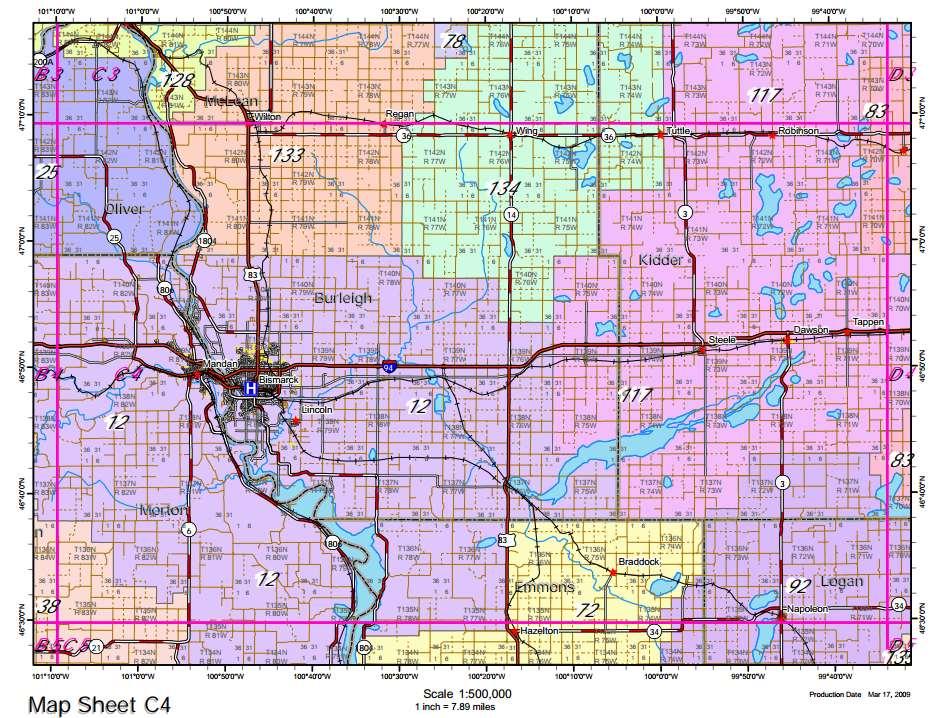
4 Source of the map:
5 EMS region 1 Introduction Emergency service unit 1 2 miles 4 miles Demand 3 Demand 2 6 miles EMS region 2 Emergency service unit 2 Demand 1 10 miles 7miles Hospital (supplier)
6 Introduction Challenges of rural EMS Insufficient revenue Difficulty in recruiting ambulance service employees and volunteers Natural barriers Changing demographics In need of collaboration and efficient operations
7 Introduction Unlikely to provide equal service and response time throughout heterogeneous service areas Needs of Scientific planning Rationalizing service coverage plans and response prediction Providing effective public service Ensuring disadvantaged groups and impaired individuals receive appropriate emergency responses
8 Objectives Designing service coverage GIS-based spatial analysis Analytical models to measure Potential accessibility with demand-covered-ratio Potential serviceability with ambulance-coveringratio Location planner and service designer to assess and provide rational service coverage Continuous improvement
9 Objectives how well the coverage matches the population distribution how quickly the ambulances serve the demands to provide maximum coverage with a fixed number of facilities.
10 Previous Studies Finding shortest path from emergency service units to crash locations searching service coverage based on the population of zip codes minimizing the required number of facilities and EMS regions using a location set covering model maximum coverage with a fixed number of facilities.
11 Previous Studies Illustration of the two-step floating catchment method (2SFCM) A F 50003=R 1U2 =2/500+5/1000 R EMS2 =5/1000 R EMS1 =2/ EMS EMS Interstate Highway
12 Data Sources Model Development Roads Network Population Data Zip codes Polygons EMS Locations Advanced Life Support Basic Life Support

13 Model Development Population density and roads

14 Gravity-Based Accessibility 2SFCA (d 0 =30minutes)
15 Response Time Fastest Routes from Ambulance to random Incidents Note: Some regions will show bias from the real practices due to unconnected roads links used in the study
16 Potential Accessibility Average response time to a zip code T t ji i z, j w N i z Potential Accessibility z i i M A z t z 0 T z

17 Potential Accessibility Index
18 Potential Accessibility Demand-covered-ratio C z (%) N( t ji N i t z 0 ) 100 i z, i M, j W i
19 Potential Accessibility Accessibility and Coverage Ratio ZIP code Required service time (t o z ) # of Random events # of events within t o z Travel Distance (miles) Response Time (minutes) Accessibility Mean Min Max Mean Min Max (A z ) Demand Covered- Ratio (C z ) % % % % % % % % % % %
20 Potential Serviceability Ambulance s average response time to serve the community without restrictions by the service boundary T j i M N j t i M ji j Serviceability index for a location t S j T j o j
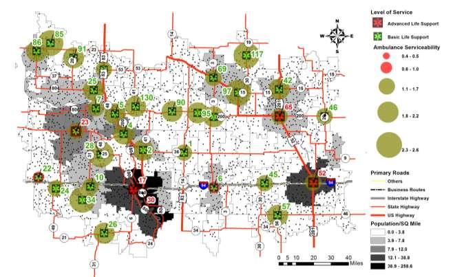
21 Potential Serviceability
22 Potential Serviceability Ambulance-Covering-Ratio C j (%) N ( i M j, t ji t0 ) N i M j j 100
23 Potential Serviceability Ambulance Location Required service time (t o j ) # of Random events # of events within t o j Travel Distance (miles) Response Time (minutes) Serviceability Mean Min Max Mean Min Max (S j ) Ambulance- Covering- Ratio (C j ) % % % % % % % % % % % % % % % %

24 Service Coverage Service Coverage Estimated
25 Conclusions Developed Public Communications tool for Residents Potential accessibility with Relative demandcovered-ratio for Ambulance Service Provider Potential serviceability with Relative ambulancecovering-ratio Created Service coverage For Continuous improvement
26 Transportation Future Research Finer Traffic Analysis Zone Using the Census Block 2010 Utilize Navigable Roads Network Statewide analysis Dynamic impacts considering seasonal effects Considering first respondents response time to reach ambulance in rural area
27 Q & A Reference and contact information
Accuracy and Precision of the NAACCR Geocoder. Recinda L Sherman, MPH CTR David J Lee, PhD University of Miami, Florida Cancer Data System
 Accuracy and Precision of the NAACCR Geocoder Recinda L Sherman, MPH CTR David J Lee, PhD University of Miami, Florida Cancer Data System Presentation Overview Overview FCDS Overview Geocoding quality
Coastside Fire Protection District
 Folsom (Sacramento), CA Management Consultants Fire Station Relocation Study for the Coastside Fire Protection District Volume 1 of 2 Main Report February 19, 2014 www.ci.pasadena.ca.us 2250 East Bidwell
Rulemaking Hearing Rules of the Tennessee Department of Health Bureau of Health Licensure and Regulation Division of Emergency Medical Services
 Rulemaking Hearing Rules of the Tennessee Department of Health Bureau of Health Licensure and Regulation Division of Emergency Medical Services Chapter 1200-12-01 General Rules Amendments of Rules Subparagraph
A GI Science Perspective on Geocoding:
 A GI Science Perspective on Geocoding: Accuracy, Repeatability and Implications for Geospatial Privacy Paul A Zandbergen Department of Geography University of New Mexico Geocoding as an Example of Applied
GPS for Route Data Collection. Lisa Aultman-Hall Dept. of Civil & Environmental Engineering University of Connecticut
 GPS for Route Data Collection Lisa Aultman-Hall Dept. of Civil & Environmental Engineering University of Connecticut Acknowledgements Reema Kundu and Eric Jackson University of Kentucky Wael ElDessouki
Vendor Accuracy Study
 Vendor Accuracy Study 2010 Estimates versus Census 2010 Household Absolute Percent Error Vendor 2 (Esri) More than 15% 10.1% to 15% 5.1% to 10% 2.5% to 5% Less than 2.5% Calculated as the absolute value
Access to Contraceptive Services in Florida
 Access to Contraceptive Services in Florida Introduction This project aims to determine which Florida county has the least access to family planning services through Title X facilities. With data gathered
Improving the Quality of Geocoded Data
 Improving the Quality of Geocoded Data NCCCP & NPCR Conference April 15, 2009 Kevin C. Ward, PhD, CTR Georgia Center for Cancer Statistics Census Geography Geographic Unit State County Census Tract (average
Using Multimodal Performance Measures to Prioritize Improvements on US 101 in San Luis Obispo County
 Portland State University PDXScholar TREC Friday Seminar Series Transportation Research and Education Center (TREC) 4-24-2015 Using Multimodal Performance Measures to Prioritize Improvements on US 101
Geocoding Address Data & Using Geocoded Data
 Geocoding Address Data & Using Geocoded Data This document located at /geocoding.pdf Using this Document & Terms of Use Copyright 2014. ProximityOne. All Rights Reserved. Geocoding Address Data Terms of
Regional Workshop on the Use of Electronic Data Collection Technologies in Population and Housing Censuses Bangkok, Jan.
 Regional Workshop on the Use of Electronic Data Collection Technologies in Population and Housing Censuses Bangkok, 23-26 Jan. 2018 1. Overview of MIS in 2015 Census 2. Functions of MIS IT Operation
Public Safety Radio Communications
 Public Safety Radio Communications Dare County, North Carolina September 18, 2006 INDEPENDENT PROFESSIONAL QUALITY DRIVEN EXPERIENCED User Organizations Sheriff County Fire Departments County EMS Departments
Position Description: BirdLife Australia Great Barrier Reef Wetlands Bird Monitoring Project Coordinator
 Position Description: BirdLife Australia Great Barrier Reef Wetlands Bird Monitoring Project Coordinator The Organisation BirdLife Australia is a member-based not-for-profit company with over 10,000 members
WAUKEE MARKETPLACE A H U R D D E V E L O P M E N T RICHIE HURD RICHARD HURD DANIEL HURD
 A H U R D D E V E L O P M E N T S W C O R N E R O F H I C K M A N R D. & A L I C E ' S R D. W A U K E E, I A 5 0 2 6 3 RICHIE HURD RICHARD HURD DANIEL HURD V I C E P R E S I D E N T P R E S I D E N T V
I-85 Integrated Corridor Management. Jennifer Portanova, PE, CPM Sreekanth Sunny Nandagiri, PE, PMP
 Jennifer Portanova, PE, CPM Sreekanth Sunny Nandagiri, PE, PMP SDITE Meeting, Columbia, SC March 2017 Agenda The I-85 ICM project in Charlotte will serve as a model to deploy similar strategies throughout
Traffic Management for Smart Cities TNK115 SMART CITIES
 Traffic Management for Smart Cities TNK115 SMART CITIES DAVID GUNDLEGÅRD DIVISION OF COMMUNICATION AND TRANSPORT SYSTEMS Outline Introduction Traffic sensors Traffic models Frameworks Information VS Control
Joint Ground/Air EMS Coverage Models. May 2008
 Joint Ground/Air EMS Coverage Models Elif Tokar Erdemir 1,2, Rajan Batta 1,2,4, Peter A. Rogerson 1,3,4, Alan Blatt 1, and Marie Flanigan 1 1: Center for Transportation Injury Research, CUBRC, Buffalo,
Link and Link Impedance 2018/02/13. VECTOR DATA ANALYSIS Network Analysis TYPES OF OPERATIONS
 VECTOR DATA ANALYSIS Network Analysis A network is a system of linear features that has the appropriate attributes for the flow of objects. A network is typically topology-based: lines (arcs) meet at intersections
SMART CITY: A SURVEY
 SMART CITY: A SURVEY 1 Sonal Ade, 2 Dr.D.V. Rojatkar 1 Student, 2 Professor Dept Of Electronics And Telecommunication Government College Of Engineering, Chandrapur, Maharastra. Abstract-A smart city is
ARCGIS DESKTOP DEMO (GEOCODING, SERVICE AREAS, TABULAR & SPATIAL JOINS)
") ARCGIS DESKTOP DEMO (GEOCODING, SERVICE AREAS, TABULAR & SPATIAL JOINS) Indiana State GIS Day Conference: September 22, 2015 ASHLEY SUITER GIS Data Analyst Epidemiology Resource Center Indiana State Department
ARCGIS DESKTOP DEMO (GEOCODING, SERVICE AREAS, TABULAR & SPATIAL JOINS) Indiana State GIS Day Conference: September 22, 2015 ASHLEY SUITER GIS Data Analyst Epidemiology Resource Center Indiana State Department
Wireless Networks for the Developing World - the regulation and use of license-exempt bands in Africa
 Wireless Networks for the Developing World - the regulation and use of license-exempt bands in Africa Isabel Neto 14 th May 2004 CITI Symposium Sharon E. Gillett and Michael L. Best Wireless technology
VLMPO Crash Report 10 Year Report Data
 Valdosta-Lowndes MPO VLMPO Crash Report 10 Year Report 2000-2009 Data An Equal Opportunity Employer / Program 327 W. Savannah Ave., Valdosta, GA 31601 Phone (229) 333-5277 Fax (229)-333-5312 1725 S. Ga.
Economic and Social Council
 United Nations Economic and Social Council Distr.: General 30 April 2012 ECE/CES/2012/32 English only Economic Commission for Europe Conference of European Statisticians Sixtieth plenary session Paris,
National Census Geography Some lessons learned and future challenges in European countries
 UNSD-AITRS Regional Workshop on the Integration of Statistical and Geospatial Information Amman, Jordan, 16-20 February, 2015 National Census Geography Some lessons learned and future challenges in European
Command Talk Group functions are managed on the Dispatch Talk Group when not assigned.
 Page 1 1. All EMS radio communication is conducted in accordance with FCC regulations and County policies. Unprofessional comments on EMS radio channels are prohibited. 2. Field Communications 2.1. Dispatch
BATTELLE AND THE SMART CITY. Turning vision into reality for tomorrow s urban environments.
 BATTELLE AND THE SMART CITY Turning vision into reality for tomorrow s urban environments. THE CITY OF THE HOSPITAL SCHOOL What makes a Smart City? It s connected. Responsive. Intelligent. It s an environment
Use of Dynamic Traffic Assignment in FSUTMS in Support of Transportation Planning in Florida
 Use of Dynamic Traffic Assignment in FSUTMS in Support of Transportation Planning in Florida Requirement Workshop December 2, 2010 Need for Assignment Estimating link flows Estimating zone to zone travel
EMERGENCY MEDICAL SERVICE LOCATION PROBLEM: A CASE STUDY IN MISURATA, LIBYA
 TRANSPORT & LOGISTICS: the International Journal Article history: Received 04 September 2017 Accepted 02 October 2017 Available online 03 October 2017 ISSN 2406-1069 Article citation info: Badi, I., Stević,
Chapter 4a GUIDE SIGNS
 Sign Designs and Markings Manual (TEM 295-2) Chapter 4a GUIDE SIGNS DIRECTIONAL ( D sign code numbers) Revised January 20, 2012 Guide Signs Directional Page 4a-2 Sign Designs and Markings Manual (TEM 295-2)
National Report of (Arab Republic of Egypt) **
 **") ADVANCE UNEDITED VERSION UNITED NATIONS E/CONF.103/9/Add.1 Economic and Social Affairs 9 July 2013 Tenth United Nations Regional Cartographic Conference for the Americas New York, 19-23, August 2013 Item
ADVANCE UNEDITED VERSION UNITED NATIONS E/CONF.103/9/Add.1 Economic and Social Affairs 9 July 2013 Tenth United Nations Regional Cartographic Conference for the Americas New York, 19-23, August 2013 Item
b. Stopping students on their way out of the cafeteria is a good way to sample if we want to know about the quality of the food there.
 Chapter 12 Sample Surveys Look at Just Checking on page 273. Various claims are made for surveys. Why is each of the following claims not correct? a. It is always better to take a census than to draw a
2014 ResearchHack RECAP FOR PAPOR MINI-CONFERENCE. AAPOR s first EVER!!! Jennie Lai, Chuck Shuttles, Anna Wiencrot & Jordon Peugh June 13th, 2014
 2014 ResearchHack RECAP FOR PAPOR MINI-CONFERENCE Jennie Lai, Chuck Shuttles, Anna Wiencrot & Jordon Peugh June 13th, 2014 AAPOR s first EVER!!! BACKGROUND: WHY A HACKATHON? It started with a conversation
MODULE 1 HAZARDOUS EMERGENCY DECISIONS
 MODULE INTRODUCTION Accidents, natural disasters, and terrorism produce chaotic homeland security situations that require a coordinated response based on sound information. GIS, when applied to these emergencies,
Copyright The McGraw-Hill Companies, Inc. Permission required for reproduction or display.
 Chapter 16. GEOCODING AND DYNAMIC SEGMENTATION 16.1 Geocoding 16.1.1 Geocoding Reference Database 16.1.2 The Address Matching Process 16.1.3 Address Matching Options Box 16.1 Scoring System for Geocoding
Sampling Terminology. all possible entities (known or unknown) of a group being studied. MKT 450. MARKETING TOOLS Buyer Behavior and Market Analysis
 of a group being studied. MKT 450. MARKETING TOOLS Buyer Behavior and Market Analysis") Sampling Terminology MARKETING TOOLS Buyer Behavior and Market Analysis Population all possible entities (known or unknown) of a group being studied. Sampling Procedures Census study containing data from
Sampling Terminology MARKETING TOOLS Buyer Behavior and Market Analysis Population all possible entities (known or unknown) of a group being studied. Sampling Procedures Census study containing data from
COASTAL MANAGEMENT ELEMENT
 COASTAL MANAGEMENT ELEMENT of the PINELLAS COUNTY COMPREHENSIVE PLAN Prepared By: The Pinellas County Planning Department as staff to the LOCAL PLANNING AGENCY for THE BOARD OF COUNTY COMMISSIONERS OF
Chapter 10. What is geocoding?
 Chapter 10 Geocoding 10-1 Copyright McGraw-Hill Education. Permission required for reproduction or display. What is geocoding? The process of assigning a location, usually in the form of coordinate values
Poverty Monitoring System in Argentina
 Implementing a Community-Based Poverty Monitoring System in Argentina Sebastian Auguste, PhD Institute of Economics - UNICEN December 2011 About Argentina Upper Middle Income Country (USD 8500 per capita
Overview of the Course Population Size
 Overview of the Course Population Size CDC 103 Lecture 1 February 5, 2012 Course Description: This course focuses on the basic measures of population size, distribution, and composition and the measures
Eastlan Ratings Radio Audience Estimate Survey Methodology
 Survey Area Eastlan Ratings Radio Audience Estimate Survey Methodology Eastlan Resources, LLC has defined each radio market surveyed into an Eastlan Survey Area (ESA). Generally, an Eastlan Survey Area
Statewide State Roads Layer Michigan Geographic Framework Field Definitions
 Statewide State Roads Layer Michigan Geographic Framework Field Definitions (Shapefile Attribute Table) (June 1, 2014 Version 14a) The following field definitions make up the shapefile attribute table
Appendix D: Preliminary Noise Evaluation
 Appendix D: Preliminary Noise Evaluation Acoustics The study of sound and its properties is known as acoustics. By considering basic physical properties of sound and the acoustic environment, the potential
WAUKEE MARKETPLACE A H U R D D E V E L O P M E N T RICHIE HURD RICHARD HURD DANIEL HURD
 A H U R D D E V E L O P M E N T H I C K M A N R O A D & A L I C E ' S R O A D W A U K E E, I A 5 0 2 6 3 RICHIE HURD RICHARD HURD DANIEL HURD V I C E P R E S I D E N T P R E S I D E N T V I C E P R E S
Connecting Manchester. How BT s Internet of Things solutions became central to the CityVerve smart city project
 How BT s Internet of Things solutions became central to the CityVerve smart city project November 2017 An introduction to CityVerve Manchester s CityVerve project brings together 21 organisations including
Hard-to-Count Overview
 Hard-to-Count Overview After each census, the U. S. Census Bureau reviews response rates. Areas that have low response rates are considered to be hard-to-count. Reasons for low response rates may be language
Abdul R. Pinjari. Associate Professor Department of Civil & Environmental Engineering University of South Florida
 Toward a Sustainable Program for Measuring, Monitoring, and Managing Transportation Systems in Indian Cities Perspectives of a Transportation Researcher from the United States Abdul R. Pinjari Associate
CHAPTER 3. Public Schools Facility Element
 CHAPTER 3 Public Schools Facility Element Page 1 of 12 CHAPTER 3 PUBLIC SCHOOL FACILITIES ELEMENT GOAL 3.1: Collaborate and coordinate with the School Board of Volusia County to provide and maintain a
Saint Lucia Country Presentation
 Saint Lucia Country Presentation Workshop on Integrating Population and Housing with Agricultural Censuses 10 th 12 th June, 2013 Edwin St Catherine Director of Statistics Household and Population Census
SGIS service in Korea
 2011. 10. 27 SGIS service in Korea 1 st UN Forum on Global Geospatial Information Management Ahn, Jae-Hack Ph.D., Deputy Director of Geospatial Service Team anny@korea.kr Twitter @globeahn Contents - GIS
CENTRAL CALIFORNIA EMERGENCY MEDICAL SERVICES
 CENTRAL CALIFORNIA EMERGENCY MEDICAL SERVICES A Division of the Fresno County Department of Public Health Manual Subject References Emergency Medical Services Administrative Policies and Procedures Authorization
RECOMMENDATION ITU-R M.1310* TRANSPORT INFORMATION AND CONTROL SYSTEMS (TICS) OBJECTIVES AND REQUIREMENTS (Question ITU-R 205/8)
 OBJECTIVES AND REQUIREMENTS (Question ITU-R 205/8)") Rec. ITU-R M.1310 1 RECOMMENDATION ITU-R M.1310* TRANSPORT INFORMATION AND CONTROL SYSTEMS (TICS) OBJECTIVES AND REQUIREMENTS (Question ITU-R 205/8) Rec. ITU-R M.1310 (1997) Summary This Recommendation
Rec. ITU-R M.1310 1 RECOMMENDATION ITU-R M.1310* TRANSPORT INFORMATION AND CONTROL SYSTEMS (TICS) OBJECTIVES AND REQUIREMENTS (Question ITU-R 205/8) Rec. ITU-R M.1310 (1997) Summary This Recommendation
Negative Externality of Traffic Congestion and Housing Values : Evidence from the US Great Lakes Megaregion
 Mid-Continent Transportation Research Symposium Negative Externality of Traffic Congestion and Housing Values : Evidence from the US Great Lakes Megaregion October 24, 2016 Jangik Jin TOPS Lab, UW-Madison
Building the best team in Lloyds Banking Group. David Littlechild, Lloyds Banking Group Nick Hayter, IBM Science & Analytics
 Building the best team in Lloyds Banking Group David Littlechild, Lloyds Banking Group Nick Hayter, IBM Science & Analytics AGENDA Introduction An external perspective Measuring organisational culture
Some Thoughts on Communications for CERT
 Jim Piper / N6MED / NREMT-B Aptos-La Selva Fire Department CERTisto Aptos, California Contact: n6med@k6bj.org / 831.662.2766 Need: The importance of effective communications between team members during
Urban WiMAX response to Ofcom s Spectrum Commons Classes for licence exemption consultation
 Urban WiMAX response to Ofcom s Spectrum Commons Classes for licence exemption consultation July 2008 Urban WiMAX welcomes the opportunity to respond to this consultation on Spectrum Commons Classes for
Civil and Environmental Engineering
 Lisa Spainhour, Professor and Interim Chair spainhour@eng.famu.fsu.edu My Research Background: Eren Ozguven Transportation Safety and Accessibility Emergency Transportation Operations Intelligent Transportation
ADVANCED TRAFFIC CLEARANCE SYSTEM FOR AMBULANCE CLEARANCE USING RF-434 MODULE
 Int. J. Chem. Sci.: 14(4), 2016, 3107-3112 ISSN 0972-768X www.sadgurupublications.com ADVANCED TRAFFIC CLEARANCE SYSTEM FOR AMBULANCE CLEARANCE USING RF-434 MODULE R. SURSHKUMAR *, R. BALAJI, G. MANIKANDAN
VACANT LAND FOR SALE. Vacant Lot for Sale 432 W Jackson St, Willard, MO 65781
 Vacant Lot for Sale 432 W Jackson St, Willard, MO 65781 VACANT Located approximately 6 miles NW of Springfield in the growing community of Willard, Missouri Zoned Commercial All utilities available rbmurray.com
There are not any on site emergency medical facilities in Holberg.
 12.2 HOLBERG Holberg is located on Holberg Inlet which has access to the Pacific Ocean on the west coast of Vancouver Island. Population is approximately 70 persons with the village located mainly at the
BETWEEN MAY 11 AND JULY 31, 2016, LAC LA BICHE COUNTY UNDERTOOK A MUNICIPAL CENSUS TO DETERMINE THE COUNTY S POPULATION AND
 BETWEEN MAY 11 AND JULY 31, 2016, LAC LA BICHE COUNTY UNDERTOOK A MUNICIPAL CENSUS TO DETERMINE THE COUNTY S POPULATION AND DEMOGRAPHICS. THE COUNTY S CENSUS DATE WAS MAY 11, 2016. PAGE 2 The Lac La Biche
MOTOROLA SOLUTIONS 2017 K-12 EDUCATION INDUSTRY SURVEY REPORT SURVEY REPORT 2017 SCHOOL COMMUNICATIONS
 MOTOROLA SOLUTIONS 2017 K-12 EDUCATION INDUSTRY SURVEY REPORT SURVEY REPORT 2017 SCHOOL COMMUNICATIONS THE POWER OF UNIFIED SCHOOL COMMUNICATIONS We look to our nation s schools as an oasis of learning,
Dallas Regional Office US Census Bureau
 The Census Bureau: Important Data Products for Every Community Paula Wright, Information Services Specialist Suzee Privett, Information Services Assistant Willie DeBerry, Partnership Specialist Lacey Loftin,
On-site Traffic Accident Detection with Both Social Media and Traffic Data
 On-site Traffic Accident Detection with Both Social Media and Traffic Data Zhenhua Zhang Civil, Structural and Environmental Engineering University at Buffalo, The State University of New York, Buffalo,
St. Johns County Fire Rescue. Community Update Presentation
 St. Johns County Fire Rescue Community Update Presentation Introduction Introduction History Overview AOR Missions Stations Apparatus Conclusion Historical perspective Provide an overview of current services
Exit 61 I-90 Interchange Modification Justification Study
 Exit 61 I-90 Interchange Modification Justification Study Introduction Exit 61 is a diamond interchange providing the connection between Elk Vale Road and I-90. Figure 1 shows the location of Exit 61.
Shopping Demands Work, Rest and Play. Graham Smith, CACI Limited 5 th November 2014 Harnessing Open Data for Business Advantage CGG Seminar
 Shopping Demands Work, Rest and Play Graham Smith, CACI Limited 5 th November 2014 Harnessing Open Data for Business Advantage CGG Seminar Agenda Overview of retail categories by customer activity Case
MOBILITY RESEARCH NEEDS FROM THE GOVERNMENT PERSPECTIVE
 MOBILITY RESEARCH NEEDS FROM THE GOVERNMENT PERSPECTIVE First Annual 2018 National Mobility Summit of US DOT University Transportation Centers (UTC) April 12, 2018 Washington, DC Research Areas Cooperative
; ECONOMIC AND SOCIAL COUNCIL
 Distr.: GENERAL ECA/DISD/STAT/RPHC.WS/ 2/99/Doc 1.4 2 November 1999 UNITED NATIONS ; ECONOMIC AND SOCIAL COUNCIL Original: ENGLISH ECONOMIC AND SOCIAL COUNCIL Training workshop for national census personnel
Optimizing Public Transit
 Optimizing Public Transit Mindy Huang Christopher Ling CS229 with Andrew Ng 1 Introduction Most applications of machine learning deal with technical challenges, while the social sciences have seen much
Lab Exercise 6: Vector Spatial Analysis
 Massachusetts Institute of Technology Department of Urban Studies and Planning 11.520: A Workshop on Geographic Information Systems 11.188: Urban Planning and Social Science Laboratory Lab Exercise 6:
GIS Lecture 8: Geocoding
 GIS Lecture 8: Geocoding 100 Elm Street 198 101 199 GIS 1 Outline Geocoding Overview Linear (Street) Geocoding Problems and Solutions Polygon Geocoding Geocoding in ArcGIS GIS 2 Geocoding Overview GIS
By using DTA, you accept the following assumptions
 Modeling Express Lanes Using Dynamic Traffic Assignment Models Yi-Chang Chiu, PhD DynusT Laboratory University of Arizona Florida DOT Managed Lane Workshop May, 03 DTA Assumptions By using DTA, you accept
Lessons from a Pilot Study for a National Probability Sample Survey of Chinese Adults Focusing on Internal Migration
 Lessons from a Pilot Study for a National Probability Sample Survey of Chinese Adults Focusing on Internal Migration Donald J. Treiman, Yao Lu, Yi Pan, Yaqiang Qi, Shige Song, and William Mason (all California
Geographic Terms. Manifold Data Mining Inc. January 2016
 Geographic Terms Manifold Data Mining Inc. January 2016 The following geographic terms are adapted from the standard definition of Census geography from Statistics Canada. Block-face A block-face is one
Geocoding and Address Matching
 LAB PREP: Geocoding and Address Matching Environmental, Earth, & Ocean Science 381 -Spring 2015 - Geocoding The process by which spatial locations are determined using coordinate locations specified in
Addressing Issues with GPS Data Accuracy and Position Update Rate for Field Traffic Studies
 Addressing Issues with GPS Data Accuracy and Position Update Rate for Field Traffic Studies THIS FEATURE VALIDATES INTRODUCTION Global positioning system (GPS) technologies have provided promising tools
MAPS & ENHANCED CONTENT
 MAPS & ENHANCED Delivering high quality maps to enterprise, government, automotive and consumer markets MAPS & SUPERIOR HOW SEAMLESS COVERAGE IS COMMUNITY DRIVEN THE FRESHEST MAP The heart of location
Advanced Techniques for Mobile Robotics Location-Based Activity Recognition
 Advanced Techniques for Mobile Robotics Location-Based Activity Recognition Wolfram Burgard, Cyrill Stachniss, Kai Arras, Maren Bennewitz Activity Recognition Based on L. Liao, D. J. Patterson, D. Fox,
True Adaptive Signal Control A Comparison of Alternatives Technical Paper #1154
 1 Smart Information for a Sustainable World True Adaptive Signal Control A Comparison of Alternatives Technical Paper #1154 Presentation to the 18 th World Congress on Intelligent Transport Systems Technical
RETAIL PADS AT THE PLANNED HIGHWAY 65 INTERCHANGE. SWC Whitney Ranch Parkway and Wildcat Boulevard, Rocklin California
 PLACER COUNTY PARCEL NUMBERS: Pad 1 (±1.554 Acres) GROUND LEASE OR BUILD-TO-SUIT Pad 2 (±1.432 Acres) GROUND LEASE OR BUILD-TO-SUIT Pad 3 (±2.315 Acres) GROUND LEASE OR BUILD-TO-SUIT Total Acres ±5.301
Header Audubon s Climate Watch
 Header Audubon s Climate Watch Subtitle Birds and climate change community science collaboration Brooke Bateman, PhD - Director of Climate Watch Climate Watch Program Overview Climate Watch Climate change
Royal Canadian Mounted Police Port Hardy Detachment There are no on-site emergency medical facilities in Holberg.
 PART 4.3 HOLBERG 4.3.1 Overview Holberg is located on Holberg Inlet which has access to the Pacific Ocean on the west coast of Vancouver Island. Population is approximately 100 persons, with the village
The Role of the Internet of Things in the Development of Smart Cities- Peter Knight PhD.
 The Role of the Internet of Things in the Development of Smart Cities- Peter Knight PhD. Why me? Ecommerce Researcher/Course Developer for 7 years prior to coming to Parkside Completed my PhD in the greater
Comparison of Simulation-Based Dynamic Traffic Assignment Approaches for Planning and Operations Management
 Comparison of Simulation-Based Dynamic Traffic Assignment Approaches for Planning and Operations Management Ramachandran Balakrishna Daniel Morgan Qi Yang Howard Slavin Caliper Corporation 4 th TRB Conference
2020 Population and Housing Census Planning Perspective and challenges for data collection
 2020 Population and Housing Census Planning Perspective and challenges for data collection Mexico Contents Background of Censuses in Mexico Planning the 2020 Census Georeferencing Statistical Information
EXECUTIVE SUMMARY. St. Louis Region Emerging Transportation Technology Strategic Plan. June East-West Gateway Council of Governments ICF
 EXECUTIVE SUMMARY St. Louis Region Emerging Transportation Technology Strategic Plan June 2017 Prepared for East-West Gateway Council of Governments by ICF Introduction 1 ACKNOWLEDGEMENTS This document
Artificial Intelligence (AI) Deep Learning IFU /
 Deep Learning IFU /") Artificial Intelligence (AI) Deep Learning IFU / 2018-02-23 1 Agenda IFU / 2018-02-23 1. About us 2. The Age of Artificial Intelligence Is Here. 3. All That Data (Big Data) 4. Pattern Recognition (Learning
Artificial Intelligence (AI) Deep Learning IFU / 2018-02-23 1 Agenda IFU / 2018-02-23 1. About us 2. The Age of Artificial Intelligence Is Here. 3. All That Data (Big Data) 4. Pattern Recognition (Learning
How can (GPS) and (GIS) Improve Ambulance Performance Levels
 and (GIS) Improve Ambulance Performance Levels") CRP 514: Introduction to GIS Term Paper Presentation How can (GPS) and (GIS) Improve Ambulance Performance Levels The supervisor: Dr. Baqer AL-Ramadan Done by: Saleh Bahartha ID 200804320 Sunday 9 th January
CRP 514: Introduction to GIS Term Paper Presentation How can (GPS) and (GIS) Improve Ambulance Performance Levels The supervisor: Dr. Baqer AL-Ramadan Done by: Saleh Bahartha ID 200804320 Sunday 9 th January
Who s in Your Neighborhood? Using the American FactFinder. Salma Abadin and Carrie Koss Vallejo Data You Can Use
 Who s in Your Neighborhood? Using the American FactFinder Salma Abadin and Carrie Koss Vallejo Data You Can Use www.datayoucanuse.org Learning Objectives Learn what American FactFinder is and is not Become
SAN DIEGO COUNTY MUTUAL AID RADIO PLAN
 ATTACHMENT A SAN DIEGO COUNTY MUTUAL AID RADIO PLAN 1.1 General Mutual aid channels are a critical part of San Diego County's radio system requirements. The San Diego County Mutual Aid Radio Plan will
WASHINGTON COUNTY-WIDE Digital Trunked P25 Phase 2 Interoperable EMERGENCY RADIO, PAGING & SYSTEM for sheriff, police, fire
 2018-2019 WASHINGTON COUNTY-WIDE Digital Trunked P25 Phase 2 Interoperable EMERGENCY RADIO, PAGING & 9-1-1 SYSTEM for sheriff, police, fire departments ems first responders & ambulance Operating from a
TOPAZ Regional Wireless Cooperative (TRWC) Board of Directors
 Board of Directors") Date: September 6, 8 To: Through: From: Subject: TOPAZ Regional Wireless Cooperative (TRWC) Board of Directors Dale Shaw, TRWC Executive Director Randy Thompson Administrator Update Capital Projects )
Date: September 6, 8 To: Through: From: Subject: TOPAZ Regional Wireless Cooperative (TRWC) Board of Directors Dale Shaw, TRWC Executive Director Randy Thompson Administrator Update Capital Projects )
The greatest achievements in our society have always been the result of good people willing to donate their time to a worthy cause.
 Thank you for being here. Today, we re going to discuss emerging trends that impact transportation. We re also going to discuss actions and decisions you can make today large and small that could shape
Scientific Communication and visual reasoning. presentation for Institute for Leadership in Technology and Management July 5, 1999 Dan Little
 Scientific Communication and visual reasoning presentation for Institute for Leadership in Technology and Management July 5, 1999 Dan Little Edward Tufte, theorist of scientific graphics A political scientist
LAND FOR SALE. Vacant Land, 7.78 acres, in northeast Springfield 2296 N. Arbor Creek Lane, Springfield, MO 65803
 Vacant Land, 7.78 acres, in northeast Springfield 2296 N. Arbor Creek Lane, Springfield, MO 65803 LAND FOR SALE 7.78 Acres located in Northeast Springfield for sale at $249,000.00 Zoned C-3 (Greene County);
Environment Around Schools and Physical Activity: GIS Protocol
 Environment Around Schools and Physical Activity: GIS Protocol Steven J. Melly, Harvard School of Public Health Angie L. Cradock, Harvard School of Public Health Steven L. Gortmaker, Harvard School of
GIS Data Sources. Thomas Talbot
 GIS Data Sources Thomas Talbot Chief, Environmental Health Surveillance Section Bureau of Environmental & Occupational Epidemiology New York State Department of Health Outline Sources of Data Census, health,
Emerging Transportation Technology Strategic Plan for the St. Louis Region Project Summary June 28, 2017
 Emerging Transportation Technology Strategic Plan for the St. Louis Region Project Summary June 28, 2017 Prepared for: East West Gateway Council of Governments Background. Motivation Process to Create
Green/Blue Metrics Meeting June 20, 2017 Summary
 Short round table introductions of participants Paul Villenueve, Carleton, Co-lead Green/Blue, Matilda van den Bosch, UBC, Co-lead Green/Blue Dan Crouse, UNB Lorien Nesbitt, UBC Audrey Smargiassi, Uof
Country Paper : Macao SAR, China
 Macao China Fifth Management Seminar for the Heads of National Statistical Offices in Asia and the Pacific 18 20 September 2006 Daejeon, Republic of Korea Country Paper : Macao SAR, China Government of