A Geodetic Reference Frame for the Virgo Interferometer
|
|
|
- Primrose Montgomery
- 5 years ago
- Views:
Transcription


1 A Geodetic Reference Frame for the Virgo Interferometer A. Paoli - European Gravitational Observatory M. Marsella, C. Nardinocchi - Università di Roma La Sapienza L. Vittuari, A. Zanutta - Università di Bologna IWAA 2016 ESRF Grenoble, 3-7 October 2016
2 2 OUTLINE Introduction: EGO and Gravitational Waves Network Surveying activities over years VRS network monumentation Establishment of VRS for Advanced Virgo Geographic Location of the detector : Alignment Activities A.Paoli - IWAA ESRF Grenoble, 3-7 October 2016


3 The European Gravitational Observatory, site of the Virgo interferometer, is located in the countryside of the Comune of Cascina, a few kilometers from town of Pisa 3


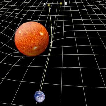
4 GENERAL RELATIVITY G mn = 8pG c 4 T mn GEOMETRY MASS-ENERGY 4


5 1 st Detection - September 14, 2015 at 09:50:45 UTC Observation of Gravitational Waves from a Binary Black Hole Merger 2 nd Detection - December 26, 2015 at 03:38:54 UTC The era of gravitational wave astronomy has started! GW Network H1- Hanford Washington State Virgo Cascina (Pisa) EGO Site GEO600 Hannover - Germany L1- Livingston Louisiana State


6 SURVEYING ACTIVITIES OVER YEARS Realization of civil engineering works: Experimental Buildings, Tunnels, Technical Buildings, Office Buildings, Roads, Bridges, Site Layout Works Main issue: realization of the 3+3km orthogonal tunnels with earth curvature correction West End Building Central Building Tunnels and Bridges Site Layout Works Construction of Tunnels EGO Main Building Inside Tunnel 6


7 SURVEYING ACTIVITIES OVER YEARS : 1 st levelling/gps surveys of the Virgo Area : Alignment of the central interferometer : Alignment of the vacuum tubes and End Towers : Monitoring of buildings/tunnel displacements : Alignment of Advanced Virgo 7
 network used for surveying activities")


8 NETWORK MONUMENTATION VRS (Virgo Reference System) network used for surveying activities developed over years and periodically checked and maintained It includes ~500 internal main reference points, materialized with accurate centering system and monographed: ~80 located in 4 Experimental Buildings GPS in the North Tunnel GPS in the West Tunnel External network made of ~30 concrete pillars distributed along the tunnels and at the experimental building areas 8


 with GNSS")
 Trimble")

9 VRS NETWORK SURVEY : Installation, survey and establishment of VRS Integrating TS measurements (red) with GNSS baselines (green) Trimble GNSS receivers; Leica TM50 & TDA Wild NL plummet 9
10 VRS ESTABLISHMENT 5 GNSS stations 3 session each lasting 24h processed separately (Bernese) - network solution including 10 permanent stations 3 solutions averaged both for the coordinates and the corresponding errors s X s Y s Z ~ 65 internal + 30 external stations TM50 (TDA5000) 3 (pos.i) + 3 (pos.ii) obs. each point Slope distance values corrected for the refraction taking into account the atmospheric parameters (T, p, RH) provided by EGO meteo station Azimuthal and Zenithal measurements corrected to refer them to the ERS (Eulerian Reference System) using formula of Brovelli M. et al. (1989) ETRF Geocentric Cartesian Reference System ERF Eulerian Reference System Appr. pos. O(x,y,z) ERS in correspondence of the center of Virgo interferometer f o, l o and (X 0, Y 0, Z 0 ) rotation angles and translation parameters ETRF ERS 10
11 VRS ESTABLISHMENT Network adjustment in ERS using both TS and GNSS observations; GNSS baselines used to constrain the network using the associated rms (s Dx, s Dy 1mm; s Dz 2mm) Network adjustment performed using both the scientific software CALGE and the commercial software StarNet (MicroSurvey Inc.) ERS coordinates finally rototranslated to VRS (Virgo Reference System) oriented in accordance with the laser beam directions (X VRS = -West beam; Y VRS = North beam) Achieved accuracy of the computed VRS coordinates s x [mm] s y [mm] s z [mm] Average St.Dev
12 VRS ESTABLISHMENT process scheme GNSS Survey in ETRF frame Definition of the ERS reference frame Transformation from ETRF to ERS of the DX, DY, DZ calculated between baselines Transformation from LRF to ERS of the TS survey TS Survey in a LRF frame Network Adjustment in the ERS. GNSS OBSERVATION USED AS DX, DY, DZ IN ORDER TO CONSTRAIN THE NETWORK Estimation of the rotation angle between ERS and VRS Estimation of the translation along x and y axis of the network towards the origin of the old reference system. The transformation parameters were calculated with a least square method on a set of five points (NV1-NV2- WV ) known both in the ERS and old VRS reference systems Shift in the Z direction, calculated as the average of the differences between NV1-NV2-WV1-108P point height, belonging to the Central Building and the corresponding heights determined by previous surveys. 12

13 GEOGRAPHIC LOCATION Establishing VRS reference frame and the transformation parameters ETRF VRS allowed the calculation of the position of the Virgo vertexes, i.e the centers of the suspended mirrors, not directly visible Coordinates calculated by the inverse transformation VRS ETRF Geographic location and orientation of Advanced Virgo respect the other detectors are fundamental informations for the contemporary detection of GW signals Point ID LAT LONG h (m) BS 43 37' 53''.1061 N 10 30' 16''.2095 E NE 43 39' 24''.9464 N 10 31' 00''.8387 E WE 43 38' 25''.4873 N 10 28' 09''.7533 E


14 ADVANCED VIRGO - SURVEY ACTIVITY Displacement and alignment of large vacuum chambers: 7 long towers (11m H; ~30 tons): BS, NI, WI, PR, SR, NE, WE 3 short towers (6.5m H; ~20 tons): IT, DT, MC Displacement range for AdV: from 2 to 626mm 14


15 ADVANCED VIRGO - SURVEY ACTIVITY Alignment of 5 new vacuum chambers minitowers : SIB2, SDB2, SPRB in Central Building SNEB, SWEB in North and West End Building 15


16 ADVANCED VIRGO - SURVEY ACTIVITY Alignment of mirror suspensions: 7 long towers: BS, NI, WI, PR, SR, NE, WE 3 short towers: IT, DT, MC 16


17 ADVANCED VIRGO - SURVEY ACTIVITY Alignment of 7 in-air and 2 in-vacuum optical benches: Injection System: LB, IB, EIB Detection System: DB, EDB Thermal Compensation System: NI, WI, NE, WE 17


18 ADVANCED VIRGO - SURVEY ACTIVITY Alignment of external references for ITF pre-commissioning activity: Central Building: PRF, NIF, SRF, WIF North End Building: NEF, SNEBF West End Building: WEF, SWEBF 18
19 ADVANCED VIRGO - SURVEY ACTIVITY Local networks around the surveyed points, including max possible number of VRS benchmarks Observations of sd, H and Z of each point repeated 3 times in both pos.i + pos.ii and averaged High redundancy of observations for the network adjustment Network adjustment performed using the commercial software StarNet (MicroSurvey Inc.) Most part of the coordinates obtained for the surveyed points with rms (s x, s y, s z ) 0.2 mm 19
20 ...THANKS for your attention A.Paoli - IWAA ESRF Grenoble, 3-7 October 2016
21 SPARE SLIDES
22 MONITORING SOIL SETTLEMENTS AT THE VIRGO SITE

 and the GPS pts. (plan.) Accurate levelings: 205 stations/tunnel 15m distance between each station and 7.")

23 MONITORING of BUILDINGS Since the end of the construction a significant subsidence of the tunnels was observed The interferometer must be in a plane Virgo and its vacuum tubes are designed for re-alignment of the modules Our reference is the Central Building (CB) Relative displacements for both the tunnel ref. pts. (H) and the GPS pts. (plan.) Accurate levelings: 205 stations/tunnel 15m distance between each station and 7.5m for the staff Not big variation of T and RH Tunnel are not ventilated Period Frequency of monitoring Instrument 2001 Initial survey TDA months NA2+GPM3; DNA months DNA months DNA03 23
![L [m] method (NA2) method (DNA03) method (DNA03) TUNNEL MONITORING Leveling parameters 3006/line NV1(WV1) N206](/docs-images/95/126000226/images/24-0.jpg "(W206); N206 NV1 BF NV1(WV1) N206 (W206); N206 NV1 BFFB, abffb n.")
 min closure error (DNA03) NV1 (WV1), N206 (W206) Avg 3 of 5; chk s/20m < 0.00005 m St > 0.")
24 L [m] method (NA2) method (DNA03) method (DNA03) TUNNEL MONITORING Leveling parameters 3006/line NV1(WV1) N206 (W206); N206 NV1 BF NV1(WV1) N206 (W206); N206 NV1 BFFB, abffb n. stations 205/line starting point measure type tolerances max closure error (NA2) min closure error (NA2) max closure error (DNA03) min closure error (DNA03) NV1 (WV1), N206 (W206) Avg 3 of 5; chk s/20m < m St > 0.5m; DBal < 0.5 m; Dmax 8m 4.42 mm 3.76 mm 0.98 mm 0.04 mm 24
25 TUNNEL MONITORING North Tunnel North Tunnel max relative subsidence: ~ 205 mm over 14 years at middle of the Tunnel 25


26 TUNNEL MONITORING West Tunnel West Tunnel max relative subsidence: ~ 170 mm over 14 years at the link Tunnel - West End Building 26


27 TUNNEL MONITORING Trendlines for the major displacements observed Analysis for max displacement at t= in the range mm Several fit curves: best R 2 according logarithmic law (order 2) or m 1 x/(m 2 +x) No big problem: settlements compatible with the realignment system (...and the roof of the tunnel!) Left curves more coherent with geotechnical studies available in literature Hypothesis with constant external factors (i.e. no large variations of the water deep stratum height or loading of the adjoining soil) 27
28 FUTURE GRAVITATIONAL WAVES PROJECT


29 GEODESY & METROLOGY for FUTURE PROJECTS Einstein Telescope 29
30 EINSTEIN TELESCOPE Conceptual Design Main features and infrastructure facilities 3 nested detectors arranged in a triangular shape with 10 km side from 100m to 200m depth underground (hopefully > 200m?) Xylophone scheme up to 6 folded interferometer 3 interferometer for Low frequency 3 for High frequency LF interferometer cryogenic test masses HF interferometer high power laser 3 underground corner caverns (Ø 65m, H 30m) and 6 satellite caverns (Ø 30m, H 30m) Tunnel inner Ø m; double tunnel (300m) linking corner and satellite caverns Surface facilities and vertical shafts (in relation to the site location) 30
31 EINSTEIN TELESCOPE Scheme of LF and HF core interferometers of a single ET detector 31
32 1985 Virgo R&D AdV aligo ET White Paper, CDR (1989) R&D Approval (1994) Final Design, TDR (1995) Beginning Infrastructure (1996) R&D Completion installation Detector (2003) First AdV sensitivity projection (2004) Scientific data taking (2007) Decommissioning (2011) AdV White Paper, CDR (2005) Approval (2009) First orders (2010) TDR (2012) Completion Installation (2015) First data taking (2016) R&D CDR (1999) R&D Funding (2006) Building (2008) Installing completion (2014) Data taking (2015) First Idea (2005) R&D CDR (2011) R&D TDR? 2025 Construction? 32
33 EINSTEIN TELESCOPE...thinking to the start of the Tech Design Design of surface and underground Reference Network Materialization of the reference points network Definition of specifications and planning for surveys and monitorings Transfer of the surface network to underground: technologies, study and design Fiducialisation and optimization of the reference point network; design for the different components of the LF and HF interferometers Integration of the fiducials in the mechanics, vacuum and optics...and many other topics! 33
VIRGO. The status of VIRGO. & INFN - Sezione di Roma 1. 1 / 6/ 2004 Fulvio Ricci
 The status of VIRGO Fulvio Ricci Dipartimento di Fisica - Università di Roma La Sapienza & INFN - Sezione di Roma 1 The geometrical effect of Gravitational Waves The signal the metric tensor perturbation
Virgo status and commissioning results
 Virgo status and commissioning results L. Di Fiore for the Virgo Collaboration 5th LISA Symposium 13 july 2004 VIRGO is an French-Italian collaboration for Gravitational Wave research with a 3 km long
The VIRGO detection system
 LIGO-G050017-00-R Paolo La Penna European Gravitational Observatory INPUT R =35 R=0.9 curv =35 0m 95 MOD CLEAN ER (14m )) WI N d:yag plar=0 ne.8 =1λ 064nm 3km 20W 6m 66.4m M odulat or PR BS N I sing lefrequ
Einstein Telescope, Supernovae. Francesco Fidecaro, Pisa Uni and INFN Pasadena, March 18, 2017
 Einstein Telescope, Supernovae Francesco Fidecaro, Pisa Uni and INFN Pasadena, March 18, 2017 Einstein Telescope Design Study Funded by European Commission as project Einstein Telescope (ET) design study
Design of control network and survey for CSNS. Accelerator center of IHEP Wang tong, Li bo
 Design of control network and survey for CSNS Accelerator center of IHEP Wang tong, Li bo 2012.09.11 Contents 1 Project Overview 2 Design of the Primary Control Network 3 Survey Scheme for the Surface
Commissioning of Advanced Virgo
 Commissioning of Advanced Virgo VSR1 VSR4 VSR5/6/7? Bas Swinkels, European Gravitational Observatory on behalf of the Virgo Collaboration GWADW Takayama, 26/05/2014 B. Swinkels Adv. Virgo Commissioning
CALIFORNIA INSTITUTE OF TECHNOLOGY Laser Interferometer Gravitational Wave Observatory (LIGO) Project
 Project") CALIFORNIA INSTITUTE OF TECHNOLOGY Laser Interferometer Gravitational Wave Observatory (LIGO) Project To/Mail Code: Distribution From/Mail Code: Dennis Coyne Phone/FAX: 395-2034/304-9834 Refer to: LIGO-T970068-00-D
CALIFORNIA INSTITUTE OF TECHNOLOGY Laser Interferometer Gravitational Wave Observatory (LIGO) Project To/Mail Code: Distribution From/Mail Code: Dennis Coyne Phone/FAX: 395-2034/304-9834 Refer to: LIGO-T970068-00-D
Advanced Virgo commissioning challenges. Julia Casanueva on behalf of the Virgo collaboration
 Advanced Virgo commissioning challenges Julia Casanueva on behalf of the Virgo collaboration GW detectors network Effect on Earth of the passage of a GW change on the distance between test masses Differential
CONTROLS CONSIDERATIONS FOR NEXT GENERATION GW DETECTORS
 CONTROLS CONSIDERATIONS FOR NEXT GENERATION GW DETECTORS CONTROLS WORKSHOP GWADW 26 MAY 2016 AGENDA Introduction (
ADVANCED VIRGO at the DAWN WORKSHOP
 Giovanni Losurdo Advanced Virgo Project Leader for the Virgo Collaboration and EGO ADVANCED VIRGO at the DAWN WORKSHOP DAWN Workshop, May 8, 2015 G Losurdo - AdV Project Leader 1 ADVANCED VIRGO! Participated
Downselection of observation bandwidth for KAGRA
 Downselection of observation bandwidth for KAGRA MG13, Stockholm Jul. 2012 K.Somiya, K.Agatsuma, M.Ando, Y.Aso, K.Hayama, N.Kanda, K.Kuroda, H.Tagoshi, R.Takahashi, K.Yamamoto, and the KAGRA collaboration
R. De Rosa INFN Napoli For the VIRGO collaboration
 R. De Rosa INFN Napoli For the VIRGO collaboration The lesson of VIRGO+ and VIRGO Science Runs; The Technical Design Report of the Advanced VIRGO project; Conclusion. CSN2 - Frascati, 16-18 Aprile 2012
THE FUTURE OF VIRGO BEYOND ADVANCED DETECTORS. Gianluca Gemme INFN Genova for the Virgo Collaboration
 THE FUTURE OF VIRGO BEYOND ADVANCED DETECTORS Gianluca Gemme INFN Genova for the Virgo Collaboration GW150914 2 Post Newtonian formalism DEVIATION OF PN COEFFICIENTS FROM GR Phase of the inspiral waveform
The realization of a 3D Reference System
 The realization of a 3D Reference System Standard techniques: topographic surveying and GNSS Observe angles and distances either between points on the Earth surface or to satellites and stars. Do not observe
The Design and Philosophy of the Tunneling Survey for the Klang Valley Underground Mass Rapid Transit Project
 The Design and Philosophy of the Tunneling Survey for the Klang Valley Underground Mass Rapid Transit, Malaysia Keywords: Underground tunnelling survey, surface network, underground network, control traverse.
What makes the positioning infrastructure work. Simon Kwok Chairman, Land Surveying Division Hong Kong Institute of Surveyors
 What makes the positioning infrastructure work The experience of the Hong Kong Satellite Positioning Reference Station Network Simon Kwok Chairman, Land Surveying Division Hong Kong Institute of Surveyors
The VIRGO injection system
 INSTITUTE OF PHYSICSPUBLISHING Class. Quantum Grav. 19 (2002) 1829 1833 CLASSICAL ANDQUANTUM GRAVITY PII: S0264-9381(02)29349-1 The VIRGO injection system F Bondu, A Brillet, F Cleva, H Heitmann, M Loupias,
Proposal of test setup
 Proposal of test setup Status of the study The Compact Linear collider (CLIC) study is a site independent feasibility study aiming at the development of a realistic technology at an affordable cost for
Some Progress In The Development Of An Optical Readout System For The LISA Gravitational Reference Sensor
 Some Progress In The Development Of An Optical Readout System For The LISA Gravitational Reference Sensor Fausto ~cernese*', Rosario De ~ osa*~, Luciano Di Fiore*, Fabio ~arufi*', Adele La ~ana*' and Leopoldo
GROUND CONTROL SURVEY REPORT
 GROUND CONTROL SURVEY REPORT Services provided by: 3001, INC. a Northrop Grumman company 10300 Eaton Place Suite 340 Fairfax, VA 22030 Ground Control Survey in Support of Topographic LIDAR, RGB Imagery
Interferometer signal detection system for the VIRGO experiment. VIRGO collaboration
 Interferometer signal detection system for the VIRGO experiment VIRGO collaboration presented by Raffaele Flaminio L.A.P.P., Chemin de Bellevue, Annecy-le-Vieux F-74941, France Abstract VIRGO is a laser
Philippine Geodetic Infrastructure Status, Challenges and Future Direction
 Philippine Geodetic Infrastructure Status, Challenges and Future Direction Engr. Charisma Victoria D. Cayapan National Mapping and Resource Information Authority PHILIPPINES Outline Evolution of Geodetic
CHAPTER 7 Total Station Surveying. CE 316 March 2012
 CHAPTER 7 Total Station Surveying CE 316 March 2012 249 7.1 Introduction Total station surveying - defined as the use of electronic survey equipment used to perform horizontal and vertical measurements
The Virgo detector. L. Rolland LAPP-Annecy GraSPA summer school L. Rolland GraSPA2013 Annecy le Vieux
 The Virgo detector The Virgo detector L. Rolland LAPP-Annecy GraSPA summer school 2013 1 Table of contents Principles Effect of GW on free fall masses Basic detection principle overview Are the Virgo mirrors
LEA_IT_COD High precision Optical Collimator. Instruments and Systems for Geotechnical and Structural Monitoring
 LEA_IT_COD1101100 High precision Optical Collimator LEA_IT_COD1101100 High precision Optical Collimator Description _ The optical alignment collimator is an instrument produced by Pizzi Instruments and
Superattenuator seismic isolation measurements by Virgo interferometer: a comparison with the future generation antenna requirements
 European Commission FP7, Grant Agreement 211143 Superattenuator seismic isolation measurements by Virgo interferometer: a comparison with the future generation antenna requirements ET-025-09 S.Braccini
Alessio Rocchi, INFN Tor Vergata
 Topics in Astroparticle and Underground Physics Torino 7-11 September 2015 Alessio Rocchi, INFN Tor Vergata On behalf of the TCS working group AdVirgo optical layout The best optics that current technology
A Thermal Compensation System for the gravitational wave detector Virgo
 A Thermal Compensation System for the gravitational wave detector Virgo M. Di Paolo Emilio University of L Aquila and INFN Roma Tor Vergata On behalf of the Virgo Collaboration Index: 1) Thermal Lensing
Possibility of Upgrading KAGRA
 The 3 rd KAGRA International Workshop @ Academia Sinica May 22, 2017 Possibility of Upgrading KAGRA Yuta Michimura Department of Physics, University of Tokyo with much help from Kentaro Komori, Yutaro
Characterizing Photodiodes of the Homodyne Detector for Advanced Virgo Squeezer
 Characterizing Photodiodes of the Homodyne Detector for Advanced Virgo Squeezer Alexandra Montesano August 1, 2017 1 Contents 1 Abstract 3 2 Introduction 3 2.1 Gravitational Waves................................
Geodetic network design and strategies followed for drilling a 25 km tunnel in a high speed railway in Spain
 Geodetic network design and strategies followed for drilling a 25 km tunnel in a high speed railway in Spain Jesus VELASCO, Juan PRIETO, Tomas HERRERO and Jose FABREGA Technical University of Madrid, Spain
Thermal correction of the radii of curvature of mirrors for GEO 600
 INSTITUTE OF PHYSICS PUBLISHING Class. Quantum Grav. 21 (2004) S985 S989 CLASSICAL AND QUANTUM GRAVITY PII: S0264-9381(04)68250-5 Thermal correction of the radii of curvature of mirrors for GEO 600 HLück
SURVEY AND ALIGNMENT FOR THE SWISS LIGHT SOURCE
 1 SURVEY AND ALIGNMENT FOR THE SWISS LIGHT SOURCE F.Q. Wei, K. Dreyer, U. Fehlmann, J.L. Pochon and A. Wrulich SLS / Paul Scherrer Institute CH5232 Villigen PSI Switzerland ABSTRACT The Swiss Light Source
Installation and Characterization of the Advanced LIGO 200 Watt PSL
 Installation and Characterization of the Advanced LIGO 200 Watt PSL Nicholas Langellier Mentor: Benno Willke Background and Motivation Albert Einstein's published his General Theory of Relativity in 1916,
The generation and application of squeezed light in gravitational wave detectors and status of the POLIS project
 The generation and application of squeezed light in gravitational wave detectors and status of the POLIS project De Laurentis* on behalf of POLIS collaboration *Università degli studi di Napoli 'Federico
From Passive to Active Control Point Networks Evaluation of Accuracy in Static GPS Surveying
 From Passive to Active Control Point Networks Evaluation of Accuracy in Static GPS Surveying P. Häkli 1, U. Kallio 1 and J. Puupponen 2 1) Finnish Geodetic Institute 2) National Land Survey of Finland
ALIGNMENT METHODS APPLIED TO THE LEP MAGNET MEASUREMENTS. J. Billan, G. Brun, K. N. Henrichsen, P. Legrand, 0. Pagano, P. Rohmig and L. Walckiers.
 295 ALIGNMENT METHODS APPLIED TO THE LEP MAGNET MEASUREMENTS J. Billan, G. Brun, K. N. Henrichsen, P. Legrand, 0. Pagano, P. Rohmig and L. Walckiers. CERN, CH-1211 Geneva 23, Switzerland Introduction Electromagnets
LONG-TERM POSITIONAL MONITORING OF STATION VYHL OF THE SNĚŽNÍK NETWORK
 Acta Geodyn. Geomater., Vol. 4, No. 4 (148), 201-206, 2007 LONG-TERM POSITIONAL MONITORING OF STATION VYHL OF THE SNĚŽNÍK NETWORK Otakar ŠVÁBENSKÝ * and Josef WEIGEL Brno University of Technology, Department
Squeezing with long (100 m scale) filter cavities
 filter cavities") 23-28 May 2016, Isola d Elba Squeezing with long (100 m scale) filter cavities Eleonora Capocasa, Matteo Barsuglia, Raffaele Flaminio APC - Université Paris Diderot Why using long filter cavities in enhanced
23-28 May 2016, Isola d Elba Squeezing with long (100 m scale) filter cavities Eleonora Capocasa, Matteo Barsuglia, Raffaele Flaminio APC - Université Paris Diderot Why using long filter cavities in enhanced
CHAPTER 3. Multi-stage seismic attenuation system
 CHAPTER 3 Multi-stage seismic attenuation system With the detection of gravitational waves, mankind has made its most precise distance measurement to date. This would not have been achievable without the
Virgo change request
 Virgo change request Quadrants photodiodes for BMS and MC end mirror Responsible: Name: Cleva Email Cleva.at.obs-nice.fr Institution: CNRS / OCA Artemis Procedure start date: 21/12/2006 Procedure end date:
Arm Cavity Finesse for Advanced LIGO
 LASER INTERFEROMETER GRAVITATIONAL WAVE OBSERVATORY - LIGO - CALIFORNIA INSTITUTE OF TECHNOLOGY MASSACHUSETTS INSTITUTE OF TECHNOLOGY Technical Note LIGO-T070303-01-D Date: 2007/12/20 Arm Cavity Finesse
National Height Modernization: Cost comparison of conducting a vertical survey by leveling versus by GPS in western North Carolina
 Introduction: National Height Modernization: Cost comparison of conducting a vertical survey by leveling versus by GPS in western North Carolina The North Carolina Geodetic Survey (NCGS) conducted a National
THE STORAGE RING CONTROL NETWORK OF NSLS-II
 THE STORAGE RING CONTROL NETWORK OF NSLS-II C. Yu #, F. Karl, M. Ilardo, M. Ke, C. Spataro, S. Sharma, BNL, Upton, NY, 11973, USA Abstract NSLS-II requires ±100 micron alignment precision to adjacent girders
3-DEMON MONITORING PLATFORM: EXAMPLES OF APPLICATIONS IN STRUCTURAL AND GEOTECHNICAL MONITORING PROJECTS
 3-DEMON MONITORING PLATFORM: EXAMPLES OF APPLICATIONS IN STRUCTURAL AND GEOTECHNICAL MONITORING PROJECTS Luca MANETTI, Daniele INAUDI and Branko GLISIC Smartec SA, Switzerland Abstract: The 3DeMoN (3-Dimentional
Results from the Stanford 10 m Sagnac interferometer
 INSTITUTE OF PHYSICSPUBLISHING Class. Quantum Grav. 19 (2002) 1585 1589 CLASSICAL ANDQUANTUM GRAVITY PII: S0264-9381(02)30157-6 Results from the Stanford 10 m Sagnac interferometer Peter T Beyersdorf,
Other Space Geodetic Techniques. E. Calais Purdue University - EAS Department Civil 3273
 Other Space Geodetic Techniques E. Calais Purdue University - EAS Department Civil 3273 ecalais@purdue.edu Satellite Laser Ranging = SLR Measurement of distance (=range) between a ground station and a
Other Space Geodetic Techniques. E. Calais Purdue University - EAS Department Civil 3273
 Other Space Geodetic Techniques E. Calais Purdue University - EAS Department Civil 3273 ecalais@purdue.edu Satellite Laser Ranging Measurement of distance (=range) between a ground station and a satellite
New Instrumentation technologies
 New Instrumentation technologies Daniel Naterop, Solexperts Ltd. Switzerland Technologies used for other application than for geotechnical instrumentation have been recently used successfully for civil
arxiv: v1 [gr-qc] 10 Sep 2007
![arxiv: v1 [gr-qc] 10 Sep 2007](/thumbs/74/70185142.jpg "arxiv: v1 [gr-qc] 10 Sep 2007") LIGO P070067 A Z A novel concept for increasing the peak sensitivity of LIGO by detuning the arm cavities arxiv:0709.1488v1 [gr-qc] 10 Sep 2007 1. Introduction S. Hild 1 and A. Freise 2 1 Max-Planck-Institut
LIGO P070067 A Z A novel concept for increasing the peak sensitivity of LIGO by detuning the arm cavities arxiv:0709.1488v1 [gr-qc] 10 Sep 2007 1. Introduction S. Hild 1 and A. Freise 2 1 Max-Planck-Institut
Development of Optical lever system of the 40 meter interferometer
 LASER INTERFEROMETER GRAVITATIONAL WAVE OBSERVATORY -LIGO- CALIFORNIA INSTITUTE OF TECHNOLOGY MASSACHUSETTS INSTITUTE OF TECHNOLOGY Technical Note x/xx/99 LIGO-T99xx- - D Development of Optical lever system
Evaluation of GPS-Based Attitude Parameters Applied to Bathymetric Measurements
 Article ID: Evaluation of GPS-Based Attitude Parameters Applied to Bathymetric Measurements Chang Chia-chyang, Lee Hsing-wei Department of Surveying and Mapping Engineering, Chung Cheng Institute of Technology
Introduction to laser interferometric gravitational wave telescope
 Introduction to laser interferometric gravitational wave telescope KAGRA summer school 013 July 31, 013 Tokyo Inst of Technology Kentaro Somiya Interferometric GW detector Far Galaxy Supernova explosion,
TEST AND CALIBRATION FACILITY FOR HLS AND WPS SENSORS
 IWAA2004, CERN, Geneva, 4-7 October 2004 TEST AND CALIBRATION FACILITY FOR HLS AND WPS SENSORS Andreas Herty, Hélène Mainaud-Durand, Antonio Marin CERN, TS/SU/MTI, 1211 Geneva 23, Switzerland 1. ABSTRACT
An Off-Axis Hartmann Sensor for Measurement of Wavefront Distortion in Interferometric Detectors
 An Off-Axis Hartmann Sensor for Measurement of Wavefront Distortion in Interferometric Detectors Aidan Brooks, Peter Veitch, Jesper Munch Department of Physics, University of Adelaide Outline of Talk Discuss
Optical lever for KAGRA
 Optical lever for KAGRA Kazuhiro Agatsuma 2014/May/16 2014/May/16 GW monthly seminar at Tokyo 1 Contents Optical lever (OpLev) development for KAGRA What is the optical lever? Review of OpLev in TAMA-SAS
Investigations of Digital Levels for High Precision Measurements
 Investigations of Digital Levels for High Precision Measurements Georg L. Gassner, Robert E. Ruland, Brendan Dix Abstract At SLAC (Stanford Linear Accelerator Center) a fully automated vertical comparator
Combining Terrestrial and GNSS Technolgies for Geodetic Monitoring. Neil ASHCROFT Leica Geosystems Engineering Segment Manager
 Combining Terrestrial and GNSS Technolgies for Geodetic Monitoring Neil ASHCROFT Leica Geosystems Engineering Segment Manager Structural Monitoring Technolgies Introduction Monitoring Instrumentation Reflectors,
determining the relative height of different
 Levelling & Contouring Principle of levelling Principle:-The principle of levelling is to obtain horizontal line of sight with respect to which vertical distances of the points above or below this line
Trimble Business Center:
 Trimble Business Center: Modernized Approaches for GNSS Baseline Processing Trimble s industry-leading software includes a new dedicated processor for static baselines. The software features dynamic selection
APPLICATION OF FULL ROVING GPS OBSERVATION STRATEGY FOR MONITORING LOCAL MOVEMENTS
 APPLICATION OF FULL ROVING GPS OBSERVATION STRATEGY FOR MONITORING LOCAL MOVEMENTS Laszlo Banyai Geodetic and Geophysical Research Institute Hungarian Academy of Sciences Email: banyai@ggki.hu Abstract:
LEVELING. Definitions
 Definitions An elevation of a point : The vertical distance between the point and the reference level surface ( datum ),the most commonly used datum is the mean sea level (MSL ). Leveling : The process
Design of the cryo-optical test of the Planck reflectors
 Design of the cryo-optical test of the Planck reflectors S. Roose, A. Cucchiaro & D. de Chambure* Centre Spatial de Liège, Avenue du Pré-Aily, B-4031 Angleur-Liège, Belgium *ESTEC, Planck project, Keplerlaan
Imaging GEOs with a Ground-Based Sparse Aperture Telescope Array
 Imaging GEOs with a Ground-Based Sparse Aperture Telescope Array Michael Werth, David Gerwe, Steve Griffin, Brandoch Calef, Paul Idell The Boeing Company ABSTRACT Ground-based imaging of GEO satellites
Accurate High-Sensitivity GPS for Short Baselines
 Tutorial 3: Positioning and map matching - Part 3: Positioning by multi sensor systems 1 for Short Baselines FIG Working Week TS 6C GPS for Engineering Volker Schwieger University Stuttgart Germany Eilat,
Chatham Island Local Tie Survey
 2016 - Chatham Island Local Tie Survey Complied by Land Information New Zealand Published: 23 September 2016 LINZ id A2407149 Contents Executive Summary... 4 Acknowledgements... 4 1. Introduction... 1
Geodesy, Geographic Datums & Coordinate Systems
 Geodesy, Geographic Datums & Coordinate Systems What is the shape of the earth? Why is it relevant for GIS? 1/23/2018 2-1 From Conceptual to Pragmatic Dividing a sphere into a stack of pancakes (latitude)
The VIRGO suspensions
 INSTITUTE OF PHYSICSPUBLISHING Class. Quantum Grav. 19 (2002) 1623 1629 CLASSICAL ANDQUANTUM GRAVITY PII: S0264-9381(02)30082-0 The VIRGO suspensions The VIRGO Collaboration (presented by S Braccini) INFN,
Parametric signal amplification
 Parametric signal amplification ET meeting @ Birmingham Mar 27, 2017 K.Somiya Observation of high freq GW sources [Kiuchi, 2010] BNS merger with different models D=100Mpc BNS merger appears above the cavity
Lecture # 7 Coordinate systems and georeferencing
 Lecture # 7 Coordinate systems and georeferencing Coordinate Systems Coordinate reference on a plane Coordinate reference on a sphere Coordinate reference on a plane Coordinates are a convenient way of
Designing Optical Layouts for AEI s 10 meter Prototype. Stephanie Wiele August 5, 2008
 Designing Optical Layouts for AEI s 10 meter Prototype Stephanie Wiele August 5, 2008 This summer I worked at the Albert Einstein Institute for Gravitational Physics as a member of the 10 meter prototype
EE119 Introduction to Optical Engineering Fall 2009 Final Exam. Name:
 EE119 Introduction to Optical Engineering Fall 2009 Final Exam Name: SID: CLOSED BOOK. THREE 8 1/2 X 11 SHEETS OF NOTES, AND SCIENTIFIC POCKET CALCULATOR PERMITTED. TIME ALLOTTED: 180 MINUTES Fundamental
The Florida control scheme. Guido Mueller, Tom Delker, David Reitze, D. B. Tanner
 The Florida control scheme Guido Mueller, Tom Delker, David Reitze, D. B. Tanner Department of Physics, University of Florida, Gainesville 32611-8440, Florida, USA The most likely conguration for the second
Zenith Line Unconventional Use of an Automatic Total Station
 Zenith Line Unconventional Use of an Automatic Total Station Joel van Cranenbroeck, Director of Technology New Business Division, Leica Geosystems AG, Switzerland Soang Hun OH, Competence Manager Extreme
Presentation Plan. The Test of Processing Modules of Global Positioning System (GPS) Softwares by Using Products of International GPS Service (IGS)
 Softwares by Using Products of International GPS Service (IGS)") The Test of Processing Modules of Global Positioning System (GPS) Softwares by Using Products of International GPS Service (IGS) Presentation Plan 1. Introduction 2. Application 3. Conclusions Ismail SANLIOGLU,
The Test of Processing Modules of Global Positioning System (GPS) Softwares by Using Products of International GPS Service (IGS) Presentation Plan 1. Introduction 2. Application 3. Conclusions Ismail SANLIOGLU,
Applications, Products and Services of GPS Technology
 Applications, Products and Services of GPS Technology Enrico C. Paringit. Dr. Eng. University of the Philippines Training Center for Applied Geodesy and Photogrammetry 1 Outline of this Presentation GPS
E-ELT Programme Science drivers
 E-ELT Overview Alistair McPherson PM E-ELT E-ELT Phase B Final Review, September 22 nd 2010 Slide 1 Science drivers Planets in other stellar systems Imaging and spectroscopy The quest for Earth-like exo-planets
Testing RTK GPS Horizontal Positioning Accuracy within an Urban Area
 Testing RTK GPS Horizontal Positioning Accuracy within an Urban Area Ismat M Elhassan* Civil Engineering Department, King Saud University, Surveying Engineering Program, Kingdom of Saudi Arabia Research
Development of C-Mod FIR Polarimeter*
 Development of C-Mod FIR Polarimeter* P.XU, J.H.IRBY, J.BOSCO, A.KANOJIA, R.LECCACORVI, E.MARMAR, P.MICHAEL, R.MURRAY, R.VIEIRA, S.WOLFE (MIT) D.L.BROWER, W.X.DING (UCLA) D.K.MANSFIELD (PPPL) *Supported
TCS beam shaping: optimum and achievable beam profiles for correcting thermo-refractive lensing (not thermo-elastic surface deformation)
") LASER INTERFEROMETER GRAVITATIONAL WAVE OBSERVATORY Laboratory / Scientific Collaboration -T1200103-v2 Date: 28-Feb-12 TCS beam shaping: optimum and achievable beam profiles for correcting thermo-refractive
LASER INTERFEROMETER GRAVITATIONAL WAVE OBSERVATORY Laboratory / Scientific Collaboration -T1200103-v2 Date: 28-Feb-12 TCS beam shaping: optimum and achievable beam profiles for correcting thermo-refractive
MEASURING METHODS FOR CROSS SECTIONS OF UNDERGROUND MINE CHAMBERS
 UNDERGROUND MINING ENGINEERING 19 (2011) 101-108 UDK 62 FACULTY OF MINING AND GEOLOGY, BELGRADE YU ISSN 03542904 Professional paper MEASURING METHODS FOR CROSS SECTIONS OF UNDERGROUND MINE CHAMBERS Ganić
The Compact Muon Solenoid Experiment at the LHC. Images of Assembly and Installation
 The Compact Muon Solenoid Experiment at the LHC Images of Assembly and Installation Contents 1. Civil Engineering Pages 8 to 13 2. Assembly in the Surface Building Pages 14 to 35 3. Lowering of the Heavy
VUV-FEL User workshop, August 23-24, 2004
 Layout of the user facility Kai Tiedtke Kai Tiedtke, HASYLAB@ VUV-FEL User workshop, August 23-24, 2004 Kai.Tiedtke@desy.de Kai Tiedtke, HASYLAB@ Outline Photon beam transport Layout of the experimental
High performance vibration isolation techniques for the AIGO gravitational wave detector
 High performance vibration isolation techniques for the AIGO gravitational wave detector Eu-Jeen Chin 2007 This thesis is presented for the degree of Doctor of Philosophy of The University of Western Australia
Vibrating Wire R&D for Alignment of Multipole Magnets in NSLS-II
 Vibrating Wire R&D for Alignment of Multipole Magnets in NSLS-II 10 th International Workshop on Accelerator Alignment February 11-15, 2008, Tsukuba, Japan Animesh Jain for the NSLS-II magnet team Collaborators
Mass Structure Deformation Monitoring using Low Cost Differential Global Positioning System Device
 American Journal of Applied Sciences 6 (1): 152-156, 2009 ISSN 1546-9239 2009 Science Publications Mass Structure Deformation Monitoring using Low Cost Differential Global Positioning System Device Ramin
aligo Hartmann Sensor Optical Layouts (H1, L1) Input Test Masses [see T and T for coordinate sources]
![aligo Hartmann Sensor Optical Layouts (H1, L1) Input Test Masses [see T and T for coordinate sources]](/thumbs/94/118294859.jpg "aligo Hartmann Sensor Optical Layouts (H1, L1) Input Test Masses [see T and T for coordinate sources]") LASER INTERFEROMETER GRAVITATIONAL WAVE OBSERVATORY Laboratory / Scientific Collaboration -T1000179-v20 Advanced Date: April 25, 2017 a Hartmann Sensor Optical Layouts (H1, L1) Input Test Masses [see T1100463
LASER INTERFEROMETER GRAVITATIONAL WAVE OBSERVATORY Laboratory / Scientific Collaboration -T1000179-v20 Advanced Date: April 25, 2017 a Hartmann Sensor Optical Layouts (H1, L1) Input Test Masses [see T1100463
Design and Manufacture of 8.4 m Primary Mirror Segments and Supports for the GMT
 Design and Manufacture of 8.4 m Primary Mirror Segments and Supports for the GMT Introduction The primary mirror for the Giant Magellan telescope is made up an 8.4 meter symmetric central segment surrounded
Determination of refractivity variations with GNSS and ultra-stable frequency standards
 Determination of refractivity variations with GNSS and ultra-stable frequency standards Markus Vennebusch, Steffen Schön, Ulrich Weinbach Institut für Erdmessung (IfE) / Institute of Geodesy Leibniz-Universität
Assessing the Impact of the SCIGN Radome on Geodetic Parameter Estimates
 Assessing the Impact of the SCIGN Radome on Geodetic Parameter Estimates John J. Braun UCAR/COSMIC Program P.O. Box 3000, Boulder, CO braunj@ucar.edu 303.497.8018 Introduction The SCIGN radome is widely
CASE STUDY BRIDGE DYNAMIC MONITORING
 Introduction BRIDGE DYNAMIC MONITORING Monitoring of structure movements and vibrations (bridges, buildings, monuments, towers etc.) is an increasingly important task for today s construction engineers.
INSTRUCTION MANUAL FOR THE MODEL C OPTICAL TESTER
 INSTRUCTION MANUAL FOR THE MODEL C OPTICAL TESTER INSTRUCTION MANUAL FOR THE MODEL C OPTICAL TESTER Data Optics, Inc. (734) 483-8228 115 Holmes Road or (800) 321-9026 Ypsilanti, Michigan 48198-3020 Fax:
Koji Arai / Stan Whitcomb LIGO Laboratory / Caltech. LIGO-G v1
 Koji Arai / Stan Whitcomb LIGO Laboratory / Caltech LIGO-G1401144-v1 General Relativity Gravity = Spacetime curvature Gravitational wave = Wave of spacetime curvature Gravitational waves Generated by motion
A gravitational wave is a differential strain in spacetime. Equivalently, it is a differential tidal force that can be sensed by multiple test masses.
 A gravitational wave is a differential strain in spacetime. Equivalently, it is a differential tidal force that can be sensed by multiple test masses. Plus-polarization Cross-polarization 2 Any system
Activity report from NICT
 Activity report from NICT APMP 2013 / TCTF meeting 25-26 November, 2013 National Institute of Information and Communications Technology (NICT) Japan 1 1 Activities of our laboratory Atomic Frequency Standards
Status Report on the Survey and Alignment Activities at Fermilab
 Status Report on the Survey and Alignment Activities at Virgil Bocean Gary Coppola John Kyle 1 Major Alignment Activities TeVnet - George Wojcik Ecool - O Sheg Oshinowo NuMI - Virgil Bocean Alignment Data
Angular control of Advanced Virgo suspended benches
 Angular control of Advanced Virgo suspended benches Michał Was for the DET and SBE team LAPP/IN2P3 - Annecy Michał Was (LAPP/IN2P3 - Annecy) GWADW, Elba, 2016 May 25 1 / 12 Suspended benches in Advanced
Record 2013/01 GeoCat 75057
 Record 2013/01 GeoCat 75057 Determination of GDA94 coordinates for station CCMB at the Clermont Coal Mine of Rio Tinto Coal Australia (RTCA) in central Queensland using the October and November 2012 GPS
Control survey for a 6.7 km immersed tunnel in Chinese Lingding ocean
 Control survey for a 6.7 km immersed tunnel in Chinese Lingding ocean This is a Peer Reviewed Paper Guanqing LI and Shengxiang HUANG, China Key words: immersed tunnel, hierarchical surface control networks,
Advanced Least Squares Adjustments for Post Processed GPS
 Advanced Least Squares Adjustments for Post Processed GPS 2018 Fall Conference October 18, 2018 College park, Maryland Instructor: Maser Consulting PA Independent Baselines The observations for GPS receivers