A Visual Index to Maps and Photographs of Redlands, California
|
|
|
- Abel Stewart
- 6 years ago
- Views:
Transcription
1 A Visual Index to Maps and Photographs of Redlands, California Jean Locke MS GIS Program University of Redlands


2


3


4


5 Libraries Armacost Library Melissa Cardenas-Dow Shana Higgins A. K. Smiley Public Library Nathan Gonzales
6 Current Issues Hard to determine from entry where the items are positioned Smiley Results Armacost Results


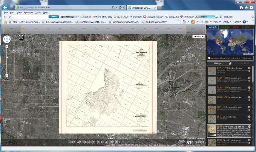
7 Hypercities

8 Alexandria Digital Library


9 David Rumsey Collection


10 Google Earth Google Maps

")

11 Current Issues (cont.) Difficult to find Requires staff help


12 Objective A graphical interface to use in a browser to display maps and photographs


13 Take - The maps and photographs Prepare the data for use by a viewer application
14 Maps used for the prototype Sheet Name Year Town Plat of Redlands 1887 Map of the City of Redlands 1890 Redlands, California 1906 Sanborn Fire Insurance map Sheet Number 12 ** 1908 Indexed map of the City of Redlands, circa Redlands, CA 1926 Bridle trails in & around Redlands, CA 1941 Topographical quad map of "Redlands and vicinity, California" 1943 City of Redlands 1955 Redlands and vicinity, and San Bernardino Mountain Area 1957 One of Series of aerial photographs of Redlands 1960 Redlands, California: street map 1971 Zoning Map, Redlands, CA 1991 Library Call Number Publisher Scale Map URL Smiley E 110:3 TOW Chambers of Commerce 1:2,400 Smiley E 120:45 MAP I. Ford, C.E., 1: Smiley E 120:6 RED I. Ford, C.E., 1:9,600 Smiley E 120:55 SAN Sanborn (-Perris) Map & Pub Co 1:600 Smiley E 120:39 IND John P Fisk Co. 1:18,000 est. * Smiley E 120:14 RED Chambers of Commerce 1:16,000 est. * Smiley E 130:61 BRI I. Ford, C.E., 1:9,600 Smiley E 130:69 TOP USGS 1:31,680 Smiley E 130:50 CIT G.S. Schott Engineering Dept 1:12,000 Smiley E 130:10 RED Daily Facts 1:21,000 est. * Smiley E 140:20 SER Pafford and Assoc., Surveyors, March 30, :12,000 Smiley E 140:11 RED Chambers of Commerce 1:24,000 est. * Armacost G4364.R3 * Some maps did not have a scale present, it was estimated (est.) ** The remainder of the footprints are other Sheet Numbers from the Sanborn Series Redlands City Planning Commission 1:12,000
15 Photographs used for prototype Picture Name PhotoYear Pic Comment Library Copyright ** PhotoURL State Street west cira * Downtown began to take form by late 1880s. This is State Street looking west between Firth and Sixth Street. A. K. Smiley Library Copyright: Picture can be found on page 19 in the... State Street west cira Orange Street cira * Orange Street cira * State Street at Christmas time 1955 Preseident McKinley at Smiley Library 1901 McKinley School 1910 * University of Redlands Chapel 1957 Original A.K. Smiley Library 1898 Painted White A.K. Smiley Library 1973 Casa Loma Hotel Unknown The southwest corner of State and Orange Streets as it looked in For 10 years, mules of Redlands Street Railway pulled... From City Hall, formerly the YMCA building, this view of Orange Street around 1900 looks north.the Fishet Building is... This is Orange Street in the mid-1920s seen from the second floor of the Union Bank. This view looks north to the intersection... A. K. Smiley Library A. K. Smiley Library A. K. Smiley Library Christmas decorations adorn State Street in The view from La Posada shows F.W. A. K. Smiley Woolworth at the southest corner of... Library President McKinley's carriage passes in front of Smiley Library. McKinley School, at the southeast corner of Olive and Center Street, was built in 1903 and razed in The Memorial Chapel, listed in the National Register of Historic Places, was designed by architect and alumnus Herbert Powell... This April 1898 view of the about-to-bededicated A.K. Smiley Public Library features its Moorish-inspired architecture.. Because architect Elmer Grey felt the library's red color overpowered his Lincoln Memorial Shrine, just south of the... This is a sketch of the Casa Loma Hotel created by Joseph Stoddard. This picture amongs others were put into a book... Eureka Street near Brookside Ave Unknown Here is a neighborhood on Eureka Street near Brookside Ave. * These are the approximate years ** The pages are part of the copyright found in the popup A. K. Smiley Library A. K. Smiley Library A. K. Smiley Library A. K. Smiley Library A. K. Smiley Library Armacost Library A. K. Smiley Library Copyright: Picture can be found on page 25 in the... Copyright: Picture can be found on page 28 in the... Copyright: Picture can be found on page 39 in the... Copyright: Picture can be found on page 42 in the... Copyright: Picture can be found on page 75 in the... Copyright: Picture can be found on page 104 in the... Copyright: Picture can be found on page 111 in the... Copyright: Picture can be found on page 118 in the... Copyright: Picture can be found on page 119 in the... Pictures can be found on page 26 in the... Pictures can be found on page 108 in the...
16 Prepare the data Scanning Presentation modification Locate on the earth Create all essential files Required software

17 Scanning Photographs Small format scanner Maps Large format scanner


18 Make Adjustments Rotate Crop to map size Modify color Brightness Contrast

 Rotate")
19 Make Adjustments (cont.) Rotate Modify color (2x) Used ERDAS

20 Locate on the Earth Photographs Geolocate

 Maps")

21 Locate on the Earth (cont.) Maps Georeference

22 Essential files

23 Project Geodatabases

24 Required Software Preparing maps and photographs Scanner software Photoshop map adjustments ArcMap georefernce/geolocate, rectification
 Further processing ArcSDE SDE feature classes ArcGIS")
25 Required Software (cont.) Further processing ArcSDE SDE feature classes ArcGIS Server Feature and Map Services
 Viewer application Flash Builder")

26 Required Software (cont.) Viewer application Flash Builder create/sustain the viewer code Library user Flash includes Flash Player Browser Internet Explorer, Firefox, Chrome, Safari, Opera
27 Viewer Application Location of viewer application Viewer framework Instruments of the application Scanned maps Footprints Photographs Display on the library user interface


28 Library interface - Armacost Find Maps and Photographs Find Maps and Photographs

29 Library interface - Smiley Maps and Photographs


30 Viewer Framework Viewer Map Navigation Switcher Instructions Side Scale Title Panel Bar


31 Initial Prototype Viewer Display


32 Initial Display (Instructions)

33 Footprints in viewer

34 Map Information Window

35 Footprints only


36 Viewing the photographs
37 Viewer Application Demonstration
38 Benefits Easier to find what maps are offered Easier to see what photographs are available Easier to see the location of the maps and photographs Easier on staff to help patrons Better serve the community
39 Overall Summary Acquire maps and photographs Scan the sources Georeference/geolocate Determine proper sequence for preparing source Finalize files Build the viewer application Create the framework Develop the working elements
40 Imminent Work (before 12/15) Incorporate any required changes Resolve bureaucratic and technical issues requiring hosting server(s) Moving application to hosting server Make appropriate changes Code URL addresses in attribute fields Final code compilation Pack my bags!
41 Future work (by a gullible C21er) Expand the application Enhancements to the Viewer Add an overview map Add time slider For photos add directional indicator Display in side panel only those maps in the main window Select rectangle footprint and retrieve map name Full Implementation with the libraries
42 Thank You
Current Functions (Enter categories from instructions) Materials (Enter categories from instructions)
 Materials (Enter categories from instructions)") Site Inventory Form State Inventory No. 92-00600 New Supplemental State Historical Society of Iowa Part of a district with known boundaries (enter inventory no.) 92-00349 (November 2005) Relationship:
Site Inventory Form State Inventory No. 92-00600 New Supplemental State Historical Society of Iowa Part of a district with known boundaries (enter inventory no.) 92-00349 (November 2005) Relationship:
Using the ModelBuilder of ArcGIS 9 for Landscape Modeling
 Using the ModelBuilder of ArcGIS 9 for Landscape Modeling Jochen MANEGOLD, ESRI-Germany Geoprocessing in GIS A geographic information system (GIS) provides a framework to support planning tasks and decisions,
Quick Guide for ArcReader GIS Installation & Use
 Town of Hanover Planning Department Quick Guide for ArcReader GIS Installation & Use For more information, contact the Town Planner, Andrew Port (781-826-7641) or port.planning@hanover-ma.gov System Requirements
ArcGIS 9 Using ArcGIS StreetMap
 ArcGIS 9 Using ArcGIS StreetMap Copyright 2001 2004 ESRI All Rights Reserved. Printed in the United States of America. The information contained in this document is the exclusive property of ESRI. This
Site Plan/Building Permit Review
 Part 6 Site Plan/Building Permit Review 1.6.01 When Site Plan Review Applies 1.6.02 Optional Pre- Application Site Plan/Building Permit Review (hereafter referred to as Site Plan Review) shall be required
Neighborhood historic house tour. Photo courtesy of the Los Angeles Public Library.
 MyPlace The purpose of MyPlace is to collect specific information about individual buildings or neighborhoods in an organized way through a variety of research activities. The research activities in MyPlace
Location Verification: Siting Tyson s 1863 Photograph of Camp Letterman General Hospital
 Location Verification: Siting Tyson s 1863 Photograph of Camp Letterman General Hospital Tom Danninger Gettysburg Magazine, Number 52, January 2015, pp. 46-51 (Article) Published by University of Nebraska
Digital Image Processing
 Digital Image Processing 1 Patrick Olomoshola, 2 Taiwo Samuel Afolayan 1,2 Surveying & Geoinformatic Department, Faculty of Environmental Sciences, Rufus Giwa Polytechnic, Owo. Nigeria Abstract: This paper
Emergency Preparedness and Planning: GIS and Critical 360. Samantha Luckhardt EGIS Supervisor City of Baltimore, Maryland
 Emergency Preparedness and Planning: GIS and Critical 360 Samantha Luckhardt EGIS Supervisor City of Baltimore, Maryland www.sitacgroup.com Types of Threats Have Changed Change in Response Tactics Response
Using 3D thematic symbology to display features in a scene
 Using 3D thematic symbology to display features in a scene www.learn.arcgis.com 380 New York Street Redlands, California 92373 8100 USA Copyright 2018 Esri All rights reserved. Printed in the United States
SPEED STEP SKETCH. SPEED STEP IT solutions for fashion companies GmbH Raiffeisenstrasse 5f Rodgau, Germany
 IT solutions for fashion companies SPEED STEP SKETCH SPEED STEP IT solutions for fashion companies GmbH Raiffeisenstrasse 5f 63110 Rodgau, Germany Phone: +49 (0) 6106 28 29 0 Fax: +49 (0) 6106 28 29 90
While entry is at the discretion of the centre, it would be beneficial if candidates had the following IT skills:
 National Unit Specification: general information CODE F916 10 SUMMARY The aim of this Unit is for candidates to gain an understanding of the different types of media assets required for developing a computer
Geocoding An Introduction
 2013 Esri International User Conference July 8 12, 2013 San Diego, California Technical Workshop Geocoding An Introduction Miriam Schmidts Agatha Wong Esri UC2013. Technical Workshop. Agenda What is geocoding?
Lesson Plan 1 Introduction to Google Earth for Middle and High School. A Google Earth Introduction to Remote Sensing
 A Google Earth Introduction to Remote Sensing Image an image is a representation of reality. It can be a sketch, a painting, a photograph, or some other graphic representation such as satellite data. Satellites
City of San Bernardino Historical and Pioneer Society P.O. Box 875, San Bernardino, CA 92402
 City of San Bernardino Historical and Pioneer Society P.O. Box 875, San Bernardino, CA 92402 LIBRARY NEWS MARCH 2011 By Richard D. Thompson, Librarian WILLIAM ADAMS VALE AN 1800 S SAN BERNARDINO PHOTOGRAPHER
Photoshop Project 1: Create Vector Art
 Photoshop Project 1: Create Vector Art Duplicate and name layers Create new layers Show and hide layers Apply the desaturate adjustment Work with the Pen tool Work with shape layers Zoom in and out of
Welcome. Camera & GPS Set-up
 Table of Contents Camera & GPS Set-up... 1 Initializing the GPS...2 Compass/Heading...2 Distance...3 Tips to get the most out of your Camera...3 GPS-Photo Link Setup: Registration...3 Program Screens...
White paper brief IdahoView Imagery Services: LISA 1 Technical Report no. 2 Setup and Use Tutorial
 White paper brief IdahoView Imagery Services: LISA 1 Technical Report no. 2 Setup and Use Tutorial Keith T. Weber, GISP, GIS Director, Idaho State University, 921 S. 8th Ave., stop 8104, Pocatello, ID
CMPT 165 INTRODUCTION TO THE INTERNET AND THE WORLD WIDE WEB
 CMPT 165 INTRODUCTION TO THE INTERNET AND THE WORLD WIDE WEB Unit 5 Graphics and Images Slides based on course material SFU Icons their respective owners 1 Learning Objectives In this unit you will learn
Current Functions (Enter categories from instructions) Materials (Enter categories from instructions)
 Materials (Enter categories from instructions)") Site Inventory Form State Inventory No. 92-00519 New Supplemental State Historical Society of Iowa Part of a district with known boundaries (enter inventory no.) 92-00349 (November 2005) Relationship:
Site Inventory Form State Inventory No. 92-00519 New Supplemental State Historical Society of Iowa Part of a district with known boundaries (enter inventory no.) 92-00349 (November 2005) Relationship:
Closing the Data Collection Circle. Stephen Osiecki GIS Manager VHB, Inc. Orlando, FL
 Closing the Data Collection Circle Stephen Osiecki GIS Manager VHB, Inc. Orlando, FL Traditional Data Collection Method Bulky Land use maps Photographs Draw features on paper maps Collect attribute information
Chapter 1 Overview of imaging GIS
 Chapter 1 Overview of imaging GIS Imaging GIS, a term used in the medical imaging community (Wang 2012), is adopted here to describe a geographic information system (GIS) that displays, enhances, and facilitates
How to Make a Hexagonal (6-Sided) Snowflake You need: paper, scissors, pencil (optional), and a trash or recycle container!
 Snowflake You need: paper, scissors, pencil (optional), and a trash or recycle container!") How to Make a Hexagonal (6-Sided) Snowflake You need: paper, scissors, pencil (optional), and a trash or recycle container! 1 Fold up the corner of a rectangular sheet of paper diagonally so the side edges
How to Make a Hexagonal (6-Sided) Snowflake You need: paper, scissors, pencil (optional), and a trash or recycle container! 1 Fold up the corner of a rectangular sheet of paper diagonally so the side edges
Google Earth for Surveyors PLSO Conference January 21, Bill Clark Earth Point
 Google Earth for Surveyors PLSO Conference January 21, 2015 Bill Clark Earth Point Introduction Bill Clark, developer of Earth Point www.earthpoint.us bill.clark@earthpoint.us 208.860.6311 Notes These
The digital microfiche/microfilm scanner allows to view, print and digitally convert library materials in these formats.
 Overview of Functions The digital microfiche/microfilm scanner allows to view, print and digitally convert library materials in these formats. The included software allows for near realtime viewing of
An Introduction to Geoprocessing
 An Introduction to Geoprocessing 1 Geoprocessing What is Geoprocessing What are Geoprocessing Models 2 What is Geoprocessing? Geoprocessing is the processing of geographic information, one of the basic
USER MANUAL VOLANS PUBLIC DISPLAY FOR JOHN WAYNE AIRPORT
 VOLANS PUBLIC DISPLAY FOR JOHN WAYNE AIRPORT BridgeNet International Contents 1 Welcome... 2 1.1 Accessibility... 2 1.2 Navigation... 2 1.3 Interface Discovery... 4 2 Menu Bar... 5 2.1 Show Flights...
ADVANCED PHOTOGRAPHY
 ADVANCED PHOTOGRAPHY Description Students will continue to develop their skills and knowledge of film exposure as well as darkroom techniques. This course introduces advanced photography techniques and
Thomas Hooper fonds. Compiled by Frances Woodward (1974, revised 2002) Last revised October University of British Columbia Archives
 Last revised October University of British Columbia Archives") Thomas Hooper fonds Compiled by Frances Woodward (1974, revised 2002) Last revised October 2011 University of British Columbia Archives Table of Contents Fonds Description o Title / Dates of Creation /
Thomas Hooper fonds Compiled by Frances Woodward (1974, revised 2002) Last revised October 2011 University of British Columbia Archives Table of Contents Fonds Description o Title / Dates of Creation /
Digital Design and Communication Teaching (DiDACT) University of Sheffield Department of Landscape. Adobe Photoshop CS5 INTRODUCTION WORKSHOPS
 University of Sheffield Department of Landscape. Adobe Photoshop CS5 INTRODUCTION WORKSHOPS") Adobe INTRODUCTION WORKSHOPS WORKSHOP 1 - what is Photoshop + what does it do? Outcomes: What is Photoshop? Opening, importing and creating images. Basic knowledge of Photoshop tools. Examples of work.
Adobe INTRODUCTION WORKSHOPS WORKSHOP 1 - what is Photoshop + what does it do? Outcomes: What is Photoshop? Opening, importing and creating images. Basic knowledge of Photoshop tools. Examples of work.
User Guide / Rules (v1.6)
") BLACKJACK MULTI HAND User Guide / Rules (v1.6) 1. OVERVIEW You play our Blackjack game against a dealer. The dealer has eight decks of cards, all mixed together. The purpose of Blackjack is to have a hand
BLACKJACK MULTI HAND User Guide / Rules (v1.6) 1. OVERVIEW You play our Blackjack game against a dealer. The dealer has eight decks of cards, all mixed together. The purpose of Blackjack is to have a hand
Finding Your Watershed with Google Earth
 Finding Your Watershed with Google Earth 1. Download the Google Earth program if you don t already have it loaded onto your computer AND you have the capacity to run the program. Refer to Google Earth
inphoto ID Canon camera control software Automatic ID photography User Guide
 inphoto ID Canon camera control software Automatic ID photography User Guide 2008 Akond company 197342, Russia, St.-Petersburg, Serdobolskaya, 65A Phone/fax: +7(812)600-6918 Cell: +7(921)757-8319 e-mail:
CATHEDRAL URBAN TRAIL: CLASSROOM ACTIVITIES Street Furniture
 CATHEDRAL URBAN TRAIL: CLASSROOM ACTIVITIES Street Furniture Introduction This activity can be carried out as a class project to produce individual art works and studies or it can be undertaken as small
Adobe Photoshop CS2 Workshop
 COMMUNITY TECHNICAL SUPPORT Adobe Photoshop CS2 Workshop Photoshop CS2 Help For more technical assistance, open Photoshop CS2 and press the F1 key, or go to Help > Photoshop Help. Selection Tools - The
ARCGIS DESKTOP DEMO (GEOCODING, SERVICE AREAS, TABULAR & SPATIAL JOINS)
") ARCGIS DESKTOP DEMO (GEOCODING, SERVICE AREAS, TABULAR & SPATIAL JOINS) Indiana State GIS Day Conference: September 22, 2015 ASHLEY SUITER GIS Data Analyst Epidemiology Resource Center Indiana State Department
ARCGIS DESKTOP DEMO (GEOCODING, SERVICE AREAS, TABULAR & SPATIAL JOINS) Indiana State GIS Day Conference: September 22, 2015 ASHLEY SUITER GIS Data Analyst Epidemiology Resource Center Indiana State Department
History, Here and Now: SFPL Resources
 History, Here and Now: SFPL Resources San Francisco Public Library s SF History Center provides a wealth of online and in person research resources. Here are a few that we will share with you during this
VECTOR ART - User Guide VECTOR ART. For Adobe Photoshop CC, CS6, CS5, CS4. User Guide
 VECTOR ART For Adobe Photoshop CC, CS6, CS5, CS4 User Guide TABLE OF CONTENTS 1. THE BASICS... 1 1.1. About the effects... 1 1.2. How the actions are organized... 1 2. INSTALLATION & TROUBLESHOOTING...
Celtx Studios Owner's Manual January 2011
 January 2011 Get the most out of Celtx Studios with the latest version of Celtx - available free at http://celtx.com Screen captures are made using Windows OS. Some image dialogs differ slightly on Mac
Applying for a Site Development Review (Sign CVCBD only)
") Guide Applying for a Site Development Review (Sign CVCBD only) What is it? Site Development Review ensures that new buildings or land uses are compatible with their sites and with the surrounding environment,
Guide Applying for a Site Development Review (Sign CVCBD only) What is it? Site Development Review ensures that new buildings or land uses are compatible with their sites and with the surrounding environment,
GEOGRAPHIC INFORMATION SYSTEMS Lecture 22: Field Mapping with GPS
 GEOGRAPHIC INFORMATION SYSTEMS Lecture 22: Field Mapping with GPS GPS Receivers - there are many GPS receivers on the market today - some receivers are relatively inexpensive (recreational grade receivers)
Memorandum. Dear Ms. Allen,
 RhoadesPlanningGroup Memorandum To: Shannon Allen, AICP, Principal Planner From: Rhoades Planning Group Date: June 10, 2015 Re: Response to Incomplete Letter, 1900 Fourth Street Dear Ms. Allen, This letter
Software requirements * : Part I: 1 hr. Part III: 2 hrs.
 Title: Product Type: Developer: Target audience: Format: Software requirements * : Data: Estimated time to complete: Using MODIS to Analyze the Seasonal Growing Cycle of Crops Part I: Understand and locate
A Web Application That Can Save You Money
 Esri Southwest Conference December 2-4, 2014 Santa Fe, NM A Web Application That Can Save You Money Colleen Swain, Swain GIS Services, LLC Brian Zheng, East Bay Municipal Utility District Problem Background
FIELD DATA COLLECTION USING SMART PHONES, TABLETS, AND GPS DEVICES: A CASE STUDY. By Wende Mix & Mary Perrelli SUNY Buffalo State College
 FIELD DATA COLLECTION USING SMART PHONES, TABLETS, AND GPS DEVICES: A CASE STUDY By Wende Mix & Mary Perrelli SUNY Buffalo State College Outline Research Question Methodology Results Summary Research Question
1949 Atlanta Aerial Mosaic Project Reveals Built Environment Change
 Georgia State University ScholarWorks @ Georgia State University Selections from the University Library Blog University Library Publications 3-24-2014 1949 Atlanta Aerial Mosaic Project Reveals Built Environment
In late April of 1986 a nuclear accident damaged a reactor at the Chernobyl nuclear
 CHERNOBYL NUCLEAR POWER PLANT ACCIDENT Long Term Effects on Land Use Patterns Project Introduction: In late April of 1986 a nuclear accident damaged a reactor at the Chernobyl nuclear power plant in Ukraine.
Geocoding Techniques and Options for US and International Locations. Thomas Oaks Tosia Shall
 Geocoding Techniques and Options for US and International Locations Thomas Oaks Tosia Shall Agenda Geocoding Overview and Requirements Geocoding in Desktop Geocoding with a Service What is Geocoding? A
BIM. e Submission Guideline Structural. Annex 1a. Recommended Process Revit 2010
 BIM e Submission Guideline Structural Annex 1a Recommended Process Revit 2010 Building and Construction Authority 5 Maxwell Road #16-00 Tower Block MND Complex Singapore 069110 www.bca.gov.sg Revision
Corps No. NWP Page 1 of 9
 DR ALOCLEK AMBERWOOD DR AMBERBROOK DR NW CORNELL RD 194TH AVE 26 Hillsboro 30 84 THORNCROFT DR Portland 5 STUCKI AVE 205 Newberg ROCKSPRING LN 210TH LN SWIRE LN AMBER VIEW LN HODES DR 206TH AVE AMBERGLEN
The student will: download an image from the Internet; and use Photoshop to straighten, crop, enhance, and resize a digital image.
 Basic Photoshop Overview: Photoshop is one of the most common computer programs used to work with digital images. In this lesson, students use Photoshop to enhance a photo of Brevig Mission School, so
Create a CaFE Account (for those who do not have one) In order to submit entries for the FWS Annual Exhibition and/or the Online Show, you need to:
 In order to submit entries for the FWS Annual Exhibition and/or the Online Show, you need to:") Using CaFE (www.callforentry.org) to Enter FWS Exhibitions To enter calls to artists for FWS shows or any calls on CaFE, you will need to: 1. Create a CaFE account. It s free and really easy to use instructions
Using CaFE (www.callforentry.org) to Enter FWS Exhibitions To enter calls to artists for FWS shows or any calls on CaFE, you will need to: 1. Create a CaFE account. It s free and really easy to use instructions
Living on a Heart Grunge by Dhanank Pambayun
 Living on a Heart Grunge by Dhanank Pambayun Dhanank Pambayun is a digital artist who lives in Jogjakarta, Indonesia. He started his career in 2002, building a personal website, www.tragikpixel.com, which
Rendering a perspective drawing using Adobe Photoshop
 Rendering a perspective drawing using Adobe Photoshop This hand-out will take you through the steps to render a perspective line drawing using Adobe Photoshop. The first important element in this process
USER MANUAL VOLANS PUBLIC DISPLAY FOR JOHN WAYNE AIRPORT
 VOLANS PUBLIC DISPLAY FOR JOHN WAYNE AIRPORT BridgeNet International Contents 1 Welcome... 2 1.1 Accessibility... 2 1.2 Navigation... 2 1.3 Map Display... 4 2 Menu Bar... 5 2.1 Show Flights... 5 2.2 Adjust
Chapter 10. What is geocoding?
 Chapter 10 Geocoding 10-1 Copyright McGraw-Hill Education. Permission required for reproduction or display. What is geocoding? The process of assigning a location, usually in the form of coordinate values
Introduction to: Microsoft Photo Story 3. for Windows. Brevard County, Florida
 Introduction to: Microsoft Photo Story 3 for Windows Brevard County, Florida 1 Table of Contents Introduction... 3 Downloading Photo Story 3... 4 Adding Pictures to Your PC... 7 Launching Photo Story 3...
Recitation 2 Introduction to Photoshop
 Recitation 2 Introduction to Photoshop What is Adobe Photoshop? Adobe Photoshop is a tool for creating digital graphics either by starting with a scanned photograph or artwork or by creating the graphics
DOWNTOWN DEVELOPMENT REVIEW BOARD APPLICATION
 This application, including the Conceptual Review Presentation, must be completed and submitted to the Downtown Development Review Board (DDRB) Staff twenty (20) business days prior to the upcoming DDRB
Campus GIS (Tsukuba University Campus Geospatial Information)
") Campus GIS (Tsukuba University Campus Geospatial Information) User Manual Draft version 3.0 20130402 Department Homepage http://giswin.geo.tsukuba.ac.jp/sis/jp/ 1 Contents 1. Graphical User Interface 2.
Campus GIS (Tsukuba University Campus Geospatial Information) User Manual Draft version 3.0 20130402 Department Homepage http://giswin.geo.tsukuba.ac.jp/sis/jp/ 1 Contents 1. Graphical User Interface 2.
Site Plan Review Application. Interest in the Property (e.g. fee simple, land option, etc.)
") 1. Identification CITY OF FENTON 301 South Leroy Street Fenton, Michigan 48430-2196 (810) 629-2261 FAX (810) 629-2004 Site Plan Review Application Project Name Applicant Name Address City/State/Zip Phone
1. Identification CITY OF FENTON 301 South Leroy Street Fenton, Michigan 48430-2196 (810) 629-2261 FAX (810) 629-2004 Site Plan Review Application Project Name Applicant Name Address City/State/Zip Phone
Inserting and Creating ImagesChapter1:
 Inserting and Creating ImagesChapter1: Chapter 1 In this chapter, you learn to work with raster images, including inserting and managing existing images and creating new ones. By scanning paper drawings
Destination Branding: GIS Shows All Your Community Has to Offer
 Destination Branding: GIS Shows All Your Community Has to Offer Strengthen Your Identity A web search is typically the way citizens, investors, and visitors begin their journey into discovering a region.
Notice of Proposed Development City of Johnston, Iowa
 Notice of Proposed Development City of Johnston, Iowa July 5, 2018 PZ Case No. 18-20; Adam Ridge Commercial Plat 1 Preliminary Plat and Site Plan Jerry s Homes, Inc. proposes to subdivide 5.14-acre Outlot
AECOsim Building Designer. Quick Start Guide. Chapter A08 Space Planning Bentley Systems, Incorporated
 AECOsim Building Designer Quick Start Guide Chapter A08 Space Planning 2012 Bentley Systems, Incorporated www.bentley.com/aecosim Table of Contents Space Planning...3 Sketches... 3 SpacePlanner... 4 Create
2. Advanced Image editing
 Aim: In this lesson, you will learn: 2. Advanced Image editing Tejas: We have some pictures with us. We want to insert these pictures in a story that we are writing. Jyoti: Some of the pictures need modification
City of Miami Planning and Zoning Department UDRB SUBMITTAL CHECK LIST
 City of Miami Planning and Zoning Department UDRB SUBMITTAL CHECK LIST One 11 x 17 signed and sealed original set and 11 copies must be submitted to the Planning and Zoning Department inclusive of all
Southeast Branch Library Project Details for Artists A Dayton Metro Library RFP for Artwork
 Southeast Branch Library Project Details for Artists A Dayton Metro Library RFP for Artwork Open To: Regional Artists (250 mile radius of Dayton, OH) Commission Amount: $40,000 is budgeted for all artworks
ArcGIS Geocoding What s New and the Road Ahead. Jeff Rogers Brad Niemand
 ArcGIS Geocoding What s New and the Road Ahead Jeff Rogers Brad Niemand Agenda Overview - ArcGIS Platform Geocoding - ArcGIS Geocoding Solutions What s New - On-Premises Geocoding Solutions - Desktop Geocoding
Ansible Tower Quick Setup Guide
 Ansible Tower Quick Setup Guide Release Ansible Tower 3.1.3 Red Hat, Inc. Feb 27, 2018 CONTENTS 1 Quick Start 2 2 Login as a Superuser 3 3 Import a License 5 4 Examine the Tower Dashboard 7 5 The Settings
Reality in Maps. Solutions for Innovative Destination Marketing
 Reality in Maps Solutions for Innovative Destination Marketing Better planning. Optimal orientation. Enhanced experiences. Digitization of the customer journey Digitization of the landscape The future
Introduction to Photoshop CS6
 Introduction to Photoshop CS6 Copyright 2016, Faculty and Staff Training, West Chester University. A member of the Pennsylvania State System of Higher Education. No portion of this document may be reproduced
Dashboard. Sep 1, Sep 30, 2009 Comparing to: Sep 1, Sep 30, % Bounce Rate. 543,744 Visits. 2,113,240 Pageviews
 www.algebra.com Dashboard Sep 1, 2009 - Sep 30, 2009 Comparing to: Sep 1, 2008 - Sep 30, 2008 Previous: Visits Visits September 7, 2009 September 14, 2009 September 21, 2009 September 28, 2 Site Usage
1940 US Federal Census
 1940 US Federal Census US 1940 Census Image Icons Census Form Data Entry Icons Data Entry Area Project Help Tabs Note the Project Help tabs in the lower right hand corner of the program. Before indexing
Architectural Walking Tour
 Architectural Awareness Activities before the walking tour: Identifying Architecture: Students view slides and/or photographs of designed places, spaces and architectural details. They consider how people
Flex Contracts for Full Time and Hourly/Overload Assignments
 Flex Contracts for Full Time and Hourly/Overload Assignments Dates to remember: Submit Your Proposed Contract by: Friday, March 16, 2012 Completed Contracts due by: Wednesday, May 16, 2012 With this new
Developer Design Review Submittal Requirements - SECTION 5
 Developer Design Review Submittal Requirements - SECTION 5 5.0 Developer Design Review 1.0 Procedures for Submittals - All Housing Types 1. Submittals shall be by the Guest Builder or authorized agent
Services Overview. Northeast Blueprint
 Services Overview 2D CAD Conversions Paper to CAD 2D CAD Conversions Construction Engineering / CAD Services Construction Markups Consultant Drawings Coordinated Drawings As -Builts Steel Structural Detailing
I've Seen That Shape Before Lesson Plan
 I've Seen That Shape Before Lesson Plan I) Overview II) Conducting the Lesson III) Teacher to Teacher IV) Handouts I. OVERVIEW Lesson Summary Students learn the names and explore properties of solid geometric
User s Guide. Windows Lucis Pro Plug-in for Photoshop and Photoshop Elements
 User s Guide Windows Lucis Pro 6.1.1 Plug-in for Photoshop and Photoshop Elements The information contained in this manual is subject to change without notice. Microtechnics shall not be liable for errors
Ansible Tower Quick Setup Guide
 Ansible Tower Quick Setup Guide Release Ansible Tower 3.2.2 Red Hat, Inc. Mar 08, 2018 CONTENTS 1 Quick Start 2 2 Login as a Superuser 3 3 Import a License 5 4 Examine the Tower Dashboard 7 5 The Settings
Undergraduate Placement Report
 Undergraduate Placement Report Rosemary Helen Mayne BSc Hons Archaeological, Anthropological and Forensic Sciences Student Ref; 4332382 (i7944093) Level H Word Count: 1,139 Placement Information; Organisation:
Working with Detail Components and Managing DetailsChapter1:
 Chapter 1 Working with Detail Components and Managing DetailsChapter1: In this chapter, you learn how to use a combination of sketch lines, imported CAD drawings, and predrawn 2D details to create 2D detail
This activity will work best with children in kindergarten through 2nd grade.
 Parent Guide SUMMARY In this simple activity children and adults will create or copy a photograph of a building, and then identify the geometric shapes that make up that building. WHY This activity will
Geocoding and Address Matching
 LAB PREP: Geocoding and Address Matching Environmental, Earth, & Ocean Science 381 -Spring 2015 - Geocoding The process by which spatial locations are determined using coordinate locations specified in
An Introduction to Histograms in Photography
 An Introduction to Histograms in Photography Histograms are a graphical representation of all the pixels that make up an image, and are plotted by 'Luminance' or brightness. Every pixel, regardless of
A Finding Aid to the John Gellatly Letters Received from Artists,
 A Finding Aid to the John Gellatly Letters Received from Artists, 1887-1931 by Judy Ng Funding for the processing and digitization of this collection was provided by the Terra Foundation for American Art.
Enhanced Library Collection Access through GIS: Historic Colorado Aerial Photographs. Kathryn Lage Christopher Cronin Holley Long
 Enhanced Library Collection Access through GIS: Historic Colorado Aerial Photographs Kathryn Lage Christopher Cronin Holley Long Abstract: This case study presents the use of GIS in a map library to create
ScanGear CS-U 5.6. for CanoScan FB1210U Color Scanner. User s Guide
 ScanGear CS-U 5.6 for CanoScan FB1210U Color Scanner User s Guide Copyright Notice Copyright 2000 Canon Inc. This manual is copyrighted with all rights reserved. Under the copyright laws, this manual may
Improve your photos and rescue old pictures
 PSPRO REVISTED Nov 5 2007 Page 1 of 7 Improve your photos and rescue old pictures This guide gives tips on how you can use Paint Shop5 and similar free graphic programmes to improve your photos. It doesn
Introduction to Total Station and GPS
 Introduction to Total Station and GPS Dr. P. NANJUNDASWAMY Professor of Civil Engineering J S S Science and Technology University S J College of Engineering Mysuru 570 006 Introduction History GPS Overview
Managing Imagery Using ArcGIS
 Managing Imagery Using ArcGIS Copyright 2010-2011 Esri All rights reserved. Course version 1.2. Version release date June 2011. Printed in the United States of America. The information contained in this
ENTRY PROCEDURE. Q. Where is the prospectus and FAQ located? A. The prospectus may be found by visiting
 Frequently Asked Questions (FAQ) Watercolor USA - Springfield Art Museum Entry Procedure Jury Process and Sales Framing, Shipping, Awards, and Returns. Watercolor Honor Society ENTRY PROCEDURE Q. Where
Kent Messamore 3/6/2010
 Post Processing Kent Messamore 3/6/2010 What we will cover Post Processing Photoshop, Lightroom, Elements, and others JPEG or RAW Photoshop Elements Workflow Organization, Create, share Photoshop Elements
PENCILS TO PAINT USING A LIMITED PALETTE
 A U T O D E S K SketchBook Pro for ipad PENCILS TO PAINT USING A LIMITED PALETTE THE ARRIVAL A Tutorial by Shaun Mullen www.mull-art.com Introduction This tutorial will take you through the steps I use
An ESRI White Paper May 2009 ArcGIS 9.3 Geocoding Technology
 An ESRI White Paper May 2009 ArcGIS 9.3 Geocoding Technology ESRI 380 New York St., Redlands, CA 92373-8100 USA TEL 909-793-2853 FAX 909-793-5953 E-MAIL info@esri.com WEB www.esri.com Copyright 2009 ESRI
Impress Guide Chapter 4 Adding and Formatting Pictures
 Impress Guide Chapter 4 Adding and Formatting Pictures This PDF is designed to be read onscreen, two pages at a time. If you want to print a copy, your PDF viewer should have an option for printing two
Scanning: pictures and text
 Scanning: pictures and text 2010 If you would like this document in an alternative format please ask staff for help. On request we can provide documents with a different size and style of font on a variety
iphoto Objective Course Outline
 iphoto Objective In this class participants will learn how iphoto creates a photo center for photo organization by using rolls and albums. Participants will also learn the built-in editing tools. Participants
ArcGIS Online: World Geocoding. Bruce Harold, Esri
 ArcGIS Online: World Geocoding Bruce Harold, Esri bharold@esri.com Nick Patel, Esri npatel@esri.com Agenda Introduction Benefits of Esri World Geocoding Overview of Esri s World Geocoding products What