Workshop on Application of Satellite Technologies for Emergencies Preparedness, Management and Response in Asia-Pacific Region - Presentation
|
|
|
- Edwin Brooks
- 5 years ago
- Views:
Transcription

1 2013/SOM1/EPWG/008a Agenda Item: Workshop on Application of Satellite Technologies for Emergencies Preparedness, Management and Response in Asia-Pacific Region - Presentation Purpose: Information Submitted by: Russia 4 th Emergency Preparedness Working Group Meeting Jakarta, Indonesia 2-3 February 2013
, EMERCOM Economy: Russian Federation 4th APEC EP WG")


2 APEC Project Application of Satellite Technologies for Emergencies Preparedness, Management and Response (EPMR) in Asia-Pacific Region Federal Space Agency (Roscosmos), EMERCOM Economy: Russian Federation 4th APEC EP WG Meeting, Jakarta, Indonesia, February 2-3, 2013 Relevance Application of Satellite Technologies for EPMR in Asia-Pacific region Since the turn of the millennium, more than one million people have been killed and 2.3 billion others have been directly affected by natural disasters around the world. According to UN statistics, the Asia-Pacific region has the largest proportion of natural disasters in the world. The region covers more than 50% of the global fatalities associated with such disasters. Nowadays satellite monitoring of natural and industrial catastrophes and emergency situations has become an important required component of information support to regional emergency services. Remote sensing technologies, especially all-weathertechnologies, ensure a rapid and objective picture of the catastrophe s scale and consequences, which is vital for the urgent rescue, humanitarian aid, and damage assessment. It is estimated that proper and timely application of modern satellite and communication technologies for disaster preparedness, management and response can reduce financial loss caused by natural disasters by 10-20%. 1

 Specific character of satellite technologies application for different types")
 in APEC region; (2) Modern and prospective satellite systems (high resolution radars, small satellite constellations, etc.")
3 Project Aims Application of Satellite Technologies for EPMR in Asia-Pacific region The project is targeted at increasing emergency preparedness of APEC economies, at proper application of innovative satellite and communication technologies, at better awareness and faster actual satellite data delivery, at development of international cooperation for Emergencies Preparedness, Management and Response (EPMR). The objective of the project is to organize and hold a Workshop «Application of Satellite Technologies for EPMR in Asia- Pacific Region». The Workshop will be organized by Russian Federal Space Agency and EMERCOM Russia and focus on the following issues: (1) Specific character of satellite technologies application for different types of emergencies (earthquakes, floods, wildfires, drought, sea surface oil pollution, etc.) in APEC region; (2) Modern and prospective satellite systems (high resolution radars, small satellite constellations, etc.) and it s application for EPMR expectations and trends; (3) Development of international cooperation and mechanisms of fast remote sensing data delivery for EPMR. Project Objectives Application of Satellite Technologies for EPMR in Asia-Pacific region APEC economies have diverse experience in the application of modern satellite and communication technologies for EPMR. The objective of the workshop is to exchange best practices and expertise in order to increase the level of APEC economies competence. A significant portion of the workshop will be a discussion between end-users of satellite data (disaster managers) and satellite designers and operators on their requirements and trends. Their views will assist in influencing the development of future emergency satellites which better corresponded to EP requirements. The workshop will target specific objectives to ensure that participants will: 1) share regional and international experience and upgrade practical skills and knowledge on application of satellite and communication technologies for EPMR; 2) enhance understanding of modern satellite systems (high resolution radars, small satellite constellations, etc.), it s capabilities, limitations and development trends applied for EPMR; 3) enhance understanding of functioning of international mechanisms on remote sensing data acquisition and its urgent distribution in case of emergency; 3)elaborate recommendations: - for future steps directed to support application of satellite technologies for EPMR in region; - for EPWG on how to further operate information exchange. 2


, space agencies (ROSCOSMOS, CSA, USGS, NOAA, NASA,")
, remote sensing satellites operators (Digital Globe, GeoEye, MDA, SPOT Image, UK DMC,")
, regional and international organizations, dealing with satellite and communication")
, Roshydromet, GEONETCast, WMO, representatives from research and")
4 Project Planned Activity Application of Satellite Technologies for EPMR in Asia-Pacific region During Project preparation the organizers are planning to work with APEC economies interested in application of satellite and communication technologies for EPMR. Additionally to APEC EP WG we hope to engage IST WG and HRD WG. It is planned to invite for participation in the workshop officials and experts from APEC economies emergency and environment ministries and agencies, international emergency organizations (Asian Disaster Reduction Center, Pacific Disaster Center, Center for International Disaster Information), space agencies (ROSCOSMOS, CSA, USGS, NOAA, NASA, CONAE, JAXA, CNSA, ESA, etc.), remote sensing satellites operators (Digital Globe, GeoEye, MDA, SPOT Image, UK DMC, ImafeSat, etc.), regional and international organizations, dealing with satellite and communication technologies in case of emergencies (UN-SPIDER, The International Charter Space and Major Disaster, SENTINEL), Roshydromet, GEONETCast, WMO, representatives from research and engineering, humanitarian and public organizations, NGOs that have used or are going to adopt the technology for disaster reduction or emergency relief. Operational monitoring of different types of disaster 3
, Google Earth")

5 Wildfire near real time monitoring Forest fires, Nigniy Novgorod region, Vyksa district, Semilovo village, June 26, 2010, Landsat-5 data (right), Google Earth (left) Wildfire near real time monitoring Снимок SPOT 4 от :32 UTC SPOT-4, Archangelsk region, , forest fire near (3 km) airport Talagi 4


6 Peatbog fires satellite monitoring LANDSAT-5. June 7, 2011, peatbog fire, Konakovo district, Tver region. This fire was not detected by MODIS sensor. Wild Fire Satellite Monitoring SPOT 4, Kalmykia Republic, , 07:28 UTC, wild fire near (5 km) oil pumping station 5


7 Steppe fire development, Astrakhan region Снимок SPOT 4 от :32 UTC Left image: FORMOSAT-2, April 1, 2012, 7:00 UTC. Burned out territory 0,2 sq. km Right image: SPOT 5, April 1, 2012, 7:57 UTC. Burned out territory 0,7 sq. km Economy experience in organization of emergency satellite monitoring - flood monitoring Ilovlya vikkage, flooded houses and roads; EROS B, ImageSat, RDC Scanex 6


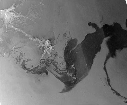
8 Satellite monitoring Mexican Gulf 2010 oil spill Oil pollution monitoring, Deepwater Horizon offshore platform accident, Mexican Gulf, April-June 2010 Tuzla Terra satellite image, May 17, 2010 Satellite monitoring Mexican Gulf 2010 oil spill Oil pollution monitoring, Deepwater Horizon offshore platform accident, Mexican Gulf, April-June 2010 Tuzla Radarsat, April 26, 2010, MDA Envisat, May 21, 2010, ESA 7
 Destroyed houses Tent camp of refugees Emergencies")

9 The consequences of the earthquake in Haiti (Port-au-Prince, ) Destroyed houses Tent camp of refugees Emergencies monitoring, Port-au-Prince, Haiti, Stadium tent camp, 2010 QuickBird, 2008, Google GeoEye-1, , GEOEYE EROS-B, , ImageSat 8


10 Archive image The consequences of the earthquake and tsunami in Japan. Port Sendai, Area of tsunami destructions The consequences of the earthquake and tsunami in Japan. NPP Fukushima-1 9
 Aircrafts crash sites monitoring.")


11 Aircrafts crash sites monitoring. Tu-154M airplane crash near Smolensk, Russia, (GeoEye, 0.6М) Aircrafts crash sites monitoring. SSJ-100 airplane crash site space images Sukhoi SuperJet-100 plane crash site on the eastern slope of the Salak mountain, Indonesia. IKONOS image, acquired on May 13, 2012 (с) GeoEye, ScanEx RDC Russian Sukhoi SuperJet- 100 (SSJ-100) airplane crash site. The accident occurred on the demonstration flight on May 9, 2012 in Indonesia. Satellite data were delivered in real-time to the EMERCOM of Russia. 3D-model of the Sukhoi SuperJet-100 plane crash site created on the base of IKONOS image from May 13, 2012 (с) GeoEye, ScanEx RDC 10

12 Maritime accidents monitoring. Costa Concordia liner crash, January 2012 EROS B image, , near the coast of Toscana. Workshop Tentative Agenda Keynote lecture: Application of Satellite and Communication Technologies for EPMR in the Asia-Pacific region. (Invited speaker TBC) Plenary Sessions: Regional and international experience in application of satellite and communication technologies for EPMR Specific characteristics of satellite technologies application for different types of emergencies (earthquakes, floods, wildfires, drought, sea surface oil pollution, etc.) in APEC region Modern and prospective satellite systems and it s application for EPMR expectations and new trends International cooperation and mechanisms of fast remote sensing data delivery for EPMR Crisis management centers regional network development Breakout sessions: Application of satellite technologies for different types of emergencies (earthquakes, floods, wildfires, drought, etc) Future development of satellite technologies and end users requirements for acquired data (sessions facilitators representatives of satellite operators SPOT, MDA, Digital Globe, ImageSat, etc) Satellite Operators and/or Emergencies Agencies Master Classes 11
13 Workshop Preparation Questions for EP WG Workshop is suggested to be held on the margins of the Seventh APEC Senior Disaster Management Officials Forum (Indonesia, August 25-30, 2013) to get better participation by group members. Questions: - Suggested dates of workshop August or August or August 31 September 1? - Exact location (place, venue)? - Additional topics for Agenda (plenary sessions, breakout discussions, master classes)? - Suggestions regarding invitation of non-member participants? - Idea(s) regarding field tour? - Primary contact person in host economy for assistance in workshop arrangement? Roscosmos Project Activity in APEC Year APEC WG Project name Status F / OF Seminar on Satellite Data Application for Sustainable Fishery Support in APEC IST APEC Network Building Applied Space Technology Centers EP Application of Satellite Technologies for Emergencies Preparedness, Management and Response in Asia Pacific Region Completed Ongoing Approved 12
14 Thank you for your attention! Application of Satellite Technologies for EPMR in Asia-Pacific region We are looking forward to your active participation in the workshop! 13
International Charter Space and Major Disasters
 International Charter Space and Major Disasters Sentinel Asia Joint Project Team Meeting July 7, 2010 Brenda Jones U.S. Geological Survey Charter Executive Secretariat Purpose An International agreement
CALL359 JAPAN S EARTHQUAKE 2011, MARCH, 11
 CALL359 JAPAN S EARTHQUAKE 2011, MARCH, 11 PM for International Charter Dr. Masahiko Nagai JAXA - AIT 25th Meeting of the International Charter May 12 th 2011 on 2011, March, 11 at 14:46 (JST) Iwate Pref.
UNISCAN AND ALICE-SC GROUND STATIONS AND DEVELOPMENT OF THEIR NETWORKS
 UNISCAN AND ALICE-SC GROUND STATIONS AND DEVELOPMENT OF THEIR NETWORKS Gershenzon V.E., Gershenzon O.N. R&D Center ScanEx Commission WG IV/9 KEY WORDS: Uniscan, Alice-SC, Stations, Geo-Portals ABSTRACT:
Building Sustainable and Resilient Communities
 2015/SOM1/EPWG/032 Agenda Item: 8.6 Building Sustainable and Resilient Communities Purpose: Information Submitted by: China 7 th Emergency Preparedness Working Group Meeting Subic, Philippines 28-29 January
Table Satellites used for observations by members of the Disaster Charter and others (except Daichi)
") 2.1.4 Cooperation with from overseas institutions JAXA asked Sentinel Asia and, on behalf of the Cabinet Office, the Disaster Charter to carry out emergency observations immediately after the earthquake
2.1.4 Cooperation with from overseas institutions JAXA asked Sentinel Asia and, on behalf of the Cabinet Office, the Disaster Charter to carry out emergency observations immediately after the earthquake
Preparedness, Response and Assessment of Oil Spill (PRAOS) Phase I
 Phase I") Preparedness, Response and Assessment of Oil Spill (PRAOS) Phase I Contents Introduction of PRAOS I Outcomes of PRAOS I Evaluation of PRAOS I Future Outlook 70% of oil consumed globally is transported
Preparedness, Response and Assessment of Oil Spill (PRAOS) Phase I Contents Introduction of PRAOS I Outcomes of PRAOS I Evaluation of PRAOS I Future Outlook 70% of oil consumed globally is transported
UNOSAT Satellite Imagery and GIS Solutions for DRR and Emergency Management
 UNOSAT Satellite Imagery and GIS Solutions for DRR and Emergency Management Francesco Pisano Director, Research, Technology Applications & Knowledge Systems January 2013 Introduction to UNOSAT 2 About
Volume 8, ISSN (Online), Published at:
, Published at:") DEVELOPMENT OF INFORMATION AND TELECOMMUNICATION AND SPACE TECHNOLOGIES USING NEW MECHANISMS OF TECHNOLOGICAL PLATFORMS Igor V. Kovalev, Yuri Y. Loginov, Pavel V. Zelenkov Siberian State Aerospace University
DEVELOPMENT OF INFORMATION AND TELECOMMUNICATION AND SPACE TECHNOLOGIES USING NEW MECHANISMS OF TECHNOLOGICAL PLATFORMS Igor V. Kovalev, Yuri Y. Loginov, Pavel V. Zelenkov Siberian State Aerospace University
Introduction of CSRSR Image product processing systems in CSRSR Disaster monitoring and data processing
 3 rd Joint Project Team Meeting for Sentinel Asia STEP3 Data Analysis Node Report Li-Yu Chang Associate Research Engineer Center for Space and Remote Sensing Research National Central University, Taiwan
Application of Satellite Remote Sensing for Natural Disasters Observation
 Application of Satellite Remote Sensing for Natural Disasters Observation Prof. Krištof Oštir, Ph.D. University of Ljubljana Faculty of Civil and Geodetic Engineering Outline Earth observation current
Problems of Data Support for Science and Applications
 Problems of Data Support for Science and Applications Vladimir Gershenzon NEESPI Science Team Meeting IIASA, Vienna, Austria, February 22-24, 2006 Types of problem - Geopolitical - Institutional - Financial
Preparedness, Response, and Assessment of Oil Spill (PRAOS) Phase I
 Phase I") 2015/SOM2/OFWG/008 Agenda Item: IV C a ii Preparedness, Response, and Assessment of Oil Spill (PRAOS) Phase I Purpose: Information Submitted by: Korea 5 th Oceans and Fisheries Working Group Meeting Boracay,
2015/SOM2/OFWG/008 Agenda Item: IV C a ii Preparedness, Response, and Assessment of Oil Spill (PRAOS) Phase I Purpose: Information Submitted by: Korea 5 th Oceans and Fisheries Working Group Meeting Boracay,
Maximize Utilization of the performance of EOSs and strengthen. The First Steering Committee Secretariat JAXA
 Maximize Utilization of the performance of EOSs and strengthen cooperation among DPN/DAN The First Steering Committee Secretariat JAXA ALOS 2 observation is strong tool for disaster monitoring Wide area/range
Satellite Contributions to Disaster Monitoring - Japanese Earthquake and Tsunami Case in
 1 Satellite Contributions to Disaster Monitoring - Japanese Earthquake and Tsunami Case in 2011 - Akira Iwasaki, Satoshi Miyatani and Shinichi Nakasuka The University of Tokyo ASTER METI/NASA 2 We express
the use of satellite radar to improve surveillance of oil pollution over large areas
 Groupe de travail ORFEO - Mer et Littoral Réunion du 14 octobre 2004 the use of satellite radar to improve surveillance of oil pollution over large areas François Parthiot Cedre - Delegate for the Mediterranean
ITU Radiocommunication Sector (ITU-R) and Climate Change. Alexandre VASSILIEV ITU Radiocommunication Bureau
 and Climate Change. Alexandre VASSILIEV ITU Radiocommunication Bureau") ITU Radiocommunication Sector (ITU-R) and Climate Change Alexandre VASSILIEV ITU Radiocommunication Bureau WSIS FORUM 2009, Geneva, 18-22 May 2009 Radio and Information Society Today radio technologies
ITU Radiocommunication Sector (ITU-R) and Climate Change Alexandre VASSILIEV ITU Radiocommunication Bureau WSIS FORUM 2009, Geneva, 18-22 May 2009 Radio and Information Society Today radio technologies
in Developing Countries in FY2008
 Study on Economic Partnership Projects in Developing Countries in FY2008 Study on Research and Development Center for Space Technology of Vietnam Academy of Science and Technology in Hoa Lac in Socialist
THE SPACE GENERATION CONGRESS 2012: Perspectives from University Students and Young Professionals in the Space Sector
 IN SUPPORT OF THE UNITED NATIONS PROGRAMME ON SPACE APPLICATIONS THE SPACE GENERATION CONGRESS 2012: Perspectives from University Students and Young Professionals in the Space Sector CONTENT What is SGAC?
TechTime New Mapping Tools for Transportation Engineering
 GeoEye-1 Stereo Satellite Imagery Presented by Karl Kliparchuk, M.Sc., GISP kkliparchuk@mcelhanney.com 604-683-8521 All satellite imagery are copyright GeoEye Corp GeoEye-1 About GeoEye Corp Headquarters:
Imagery Archive Works
 USDA How Satellite the Imagery USDA s Archive Satellite Imagery Archive Works A. What is the USDA Satellite Imagery Archive? B. What are the benefits of participating in the USDA Archive? C. What types
Second APEC Ministers' Conference on Regional Science & Technology Cooperation (Seoul, Korea, Nov 13-14, 1996) JOINT COMMUNIQUÉ
 JOINT COMMUNIQUÉ") Second APEC Ministers' Conference on Regional Science & Technology Cooperation (Seoul, Korea, Nov 13-14, 1996) JOINT COMMUNIQUÉ 1. Ministers responsible for science and technology from Australia, Brunei
Second APEC Ministers' Conference on Regional Science & Technology Cooperation (Seoul, Korea, Nov 13-14, 1996) JOINT COMMUNIQUÉ 1. Ministers responsible for science and technology from Australia, Brunei
Overview of how remote sensing is used by the wildland fire community.
 Overview of how remote sensing is used by the wildland fire community. Presented to the ASEN 6210 Remote Sensing Seminar on 2/18/04 by: Jeff Baranyi ESRI Denver Reported by Gary Fager. Images are from
ENGAGING SPACE TOOLS FOR DEVELOPMENT ON EARTH: CONTRIBUTION OF SPACE TECHNOLOGY AND APPLICATIONS TO THE POST-2015 DEVELOPMENT AGENDA
 ENGAGING SPACE TOOLS FOR DEVELOPMENT ON EARTH: CONTRIBUTION OF SPACE TECHNOLOGY AND APPLICATIONS TO THE POST-2015 DEVELOPMENT AGENDA SIMONETTA DI PIPPO, DIRECTOR United Nations Office for Outer Space Affairs
XSAT Ground Segment at CRISP
 XSAT Ground Segment at CRISP LIEW Soo Chin Head of Research, CRISP http://www.crisp.nus.edu.sg 5 th JPTM for Sentinel Asia Step-2, 14-16 Nov 2012, Daejeon, Korea Centre for Remote Imaging, Sensing and
General Assembly. United Nations A/AC.105/C.1/L.335/Add.4. Draft report
 United Nations General Assembly Distr.: Limited 20 February 2014 Original: English Committee on the Peaceful Uses of Outer Space Scientific and Technical Subcommittee Fifty-first session Vienna, 10-21
SECOND OPEN SKIES REVIEW CONFERENCE (OSRC) 2010
 2010") OSCC.RC/40/10 9 June 2010 Open Skies Consultative Commission ENGLISH only US Chair of the OSCC Review Conference SECOND OPEN SKIES REVIEW CONFERENCE (OSRC) 2010 7 to 9 June 2010 Working Session 2 Exploring
OSCC.RC/40/10 9 June 2010 Open Skies Consultative Commission ENGLISH only US Chair of the OSCC Review Conference SECOND OPEN SKIES REVIEW CONFERENCE (OSRC) 2010 7 to 9 June 2010 Working Session 2 Exploring
ISA S DATA SHARING AND GROUND RECEIVING STATION DEVELOPMENTS
 ISA S DATA SHARING AND GROUND RECEIVING STATION DEVELOPMENTS Parviz Tarikhi Microwave Remote Sensing Research Core Mahdasht Satellite Receiving Station, ISA parviz_tarikhi@hotmail.com ABSTRACT Remote Sensing
United nation, Vienna, 9-13 February 2015
 United nation, Vienna, 9-13 February 2015 RUSSIAN FEDERAL SPACE AGENCY In the Russian Federation, the federal agency in charge of space activities is the Russian Federal Space Agency (Roscosmos) Earth
Image interpretation. Aliens create Indian Head with an ipod? Badlands Guardian (CBC) This feature can be found 300 KMs SE of Calgary.
 This feature can be found 300 KMs SE of Calgary.") Image interpretation Aliens create Indian Head with an ipod? Badlands Guardian (CBC) This feature can be found 300 KMs SE of Calgary. 50 1 N 110 7 W Milestones in the History of Remote Sensing 19 th century
Image interpretation Aliens create Indian Head with an ipod? Badlands Guardian (CBC) This feature can be found 300 KMs SE of Calgary. 50 1 N 110 7 W Milestones in the History of Remote Sensing 19 th century
The 21 st APEC Small and Medium Enterprises Ministerial Meeting Joint Ministerial Statement. Nanjing, China September 5, 2014
 The 21 st APEC Small and Medium Enterprises Ministerial Meeting Joint Ministerial Statement Nanjing, China September 5, 2014 Innovation and Sustainability Introduction 1. We, the APEC Ministers and their
(Beijing, China,25 May2017)
") Remarks by the Secretary General of the International Civil Aviation Organization (ICAO), Dr. Fang Liu, to the First Session of the 2017 China Civil Aviation Development Forum: New Opportunities for Aviation
Remarks by the Secretary General of the International Civil Aviation Organization (ICAO), Dr. Fang Liu, to the First Session of the 2017 China Civil Aviation Development Forum: New Opportunities for Aviation
Note that some are my own photos, comments, and opinions - Not necessary reflecting WB GFDRR s views
 1 Session 7: The Recovery Process Note that some are my own photos, comments, and opinions - Not necessary reflecting WB GFDRR s views Yuichi Ono Professor, International and Regional Cooperation Office
From the JUSTSAP to the PISA
 From the JUSTSAP to the PISA Osamu Odawara, Tokyo Institute of Technology Japan-US Science, Technology, and Space Application Program Pacific International Space Alliance JUSTSAP ( established in 1990
Global Land Survey Activities and Land Cover Analysis from Landsat
 Global Land Survey Activities and Land Cover Analysis from Landsat Shannon Franks, SGT/NASA Jeffrey G. Masek, NASA GSFC Garik Gutman, NASA HQ Rachel Headley, USGS CODATA, October 25, 2010 Background the
FINAL ANNOUNCEMENT The 1 st Space Exploration and Kibo Utilization for Asia Workshop. LAPAN Headquarters, Jakarta, Indonesia.
 FINAL ANNOUNCEMENT The 1 st Space Exploration and Kibo Utilization for Asia Workshop LAPAN Headquarters, Jakarta, Indonesia May 28, 2015 We are pleased to announce that The 1st Space Exploration and Kibo
The 21st Session of the Asia-Pacific Regional Space Agency Forum (APRSAF): Dawn of a New Decade
: Dawn of a New Decade") The 21st Session of the Asia-Pacific Regional Space Agency Forum (APRSAF): Dawn of a New Decade 52 nd Session of Scientific and Technical Subcommittee Kazuhiro MIYAZAKI Office for Space Utilization Promotion,
The 21st Session of the Asia-Pacific Regional Space Agency Forum (APRSAF): Dawn of a New Decade 52 nd Session of Scientific and Technical Subcommittee Kazuhiro MIYAZAKI Office for Space Utilization Promotion,
REPORT ON THE STATUS OF CURRENT AND FUTURE RUSSIAN SATELLITE SYSTEMS
 Prepared by ROSH/ROSC Agenda Item: Session D Discussed in Plenary REPORT ON THE STATUS OF CURRENT AND FUTURE RUSSIAN SATELLITE SYSTEMS This document addresses the current status of the satellite systems:
Radio Frequency Sensing from Space
 Radio Frequency Sensing from Space Edoardo Marelli ITU-R WP 7C Chairman ITU-R Seminar Manta (Ecuador) 20 September 2012 Why observing the Earth from space? Satellites orbiting around the Earth offer an
SPACE TECHNOLOGY INSTITUTE AND VNREDSat-1
 The First Steering Committee (FSC) of The Sentinel Asia Step 3 13-15 Oct 2015 SPACE TECHNOLOGY INSTITUTE AND VNREDSat-1 Ngo Duy Tan Deputy Director, Centre for Small Satellite Control and Exploitation,
Data acquisition and access for the Congo Basin
 MRV Joint Workshop 22-24 June 2010, Guadalajara, Jalisco Mexico Data acquisition and access for the Congo Basin Landing Mané 1, Michael Brady 2, Chris Justice 3 and Alice Altstatt 3 1) Satellite Observatory
Earth Observations from Space U.S. Geological Survey
 Earth Observations from Space U.S. Geological Survey Geography Land Remote Sensing Program Dr. Bryant Cramer April 1, 2009 U.S. Department of the Interior U.S. Geological Survey USGS Landsat Historical
Introduction to Remote Sensing Fundamentals of Satellite Remote Sensing. Mads Olander Rasmussen
 Introduction to Remote Sensing Fundamentals of Satellite Remote Sensing Mads Olander Rasmussen (mora@dhi-gras.com) 01. Introduction to Remote Sensing DHI What is remote sensing? the art, science, and technology
Remote sensing radio applications/ systems for environmental monitoring
 Remote sensing radio applications/ systems for environmental monitoring Alexandre VASSILIEV ITU Radiocommunication Bureau phone: +41 22 7305924 e-mail: alexandre.vassiliev@itu.int 1 Source: European Space
SAR Interferometry Capabilities of Canada's planned SAR Satellite Constellation
 SAR Interferometry Capabilities of Canada's planned SAR Satellite Constellation Dirk Geudtner, Guy Séguin,, Ralph Girard Canadian Space Agency RADARSAT Follow-on Program CSA is in the middle of a Phase
The Space Frequency Coordination Group (SFCG)
") The Space Frequency Coordination Group (SFCG) Edoardo Marelli ITU-R WP 7C Chairman and SFCG Executive Secretary ITU-R Seminar Manta (Ecuador) 20 September 2012 The SFCG in a nutshell The SFCG in a nutshell
The Space Frequency Coordination Group (SFCG) Edoardo Marelli ITU-R WP 7C Chairman and SFCG Executive Secretary ITU-R Seminar Manta (Ecuador) 20 September 2012 The SFCG in a nutshell The SFCG in a nutshell
General Assembly. United Nations A/AC.105/L.271/Add.3. Draft report. Chapter II
 United Nations General Assembly Distr.: Limited 18 June 2008 Original: English Committee on the Peaceful Uses of Outer Space Fifty-first session Vienna, 11-20 June 2008 Draft report Chapter II Addendum
Remote sensing system Resurs-P
 Joint-stock company «Space rocket center «Progress» Remote sensing system Resurs-P Alexander N. Kirilin, Ravil N. Akhmetov, Nikolay R. Stratilatov, Alexander I. Baklanov Speaker: Maxim V. Klyushnikov October
Resurs-P Earth Remote Sensing constellation A. Kirilin, R. Akhmetov, N. Stratilatov, A. Baklanov JSC Space-Rocket Centre PROGRESS, Samara, Russia
 17 th International Scientific and Technical Conference FROM IMAGERY TO DIGITAL REALITY: ERS & Photogrammetry Resurs-P Earth Remote Sensing constellation A. Kirilin, R. Akhmetov, N. Stratilatov, A. Baklanov
2015/SOM2/PPSTI/001 Agenda Item: 2. Draft Agenda. Purpose: Consideration Submitted by: Chair
 2015/SOM2/PPSTI/001 Agenda Item: 2 Draft Agenda Purpose: Consideration Submitted by: Chair 5 th Policy Partnership on Science, Technology and Innovation Meeting Boracay, Philippines 16-18 May 2015 5 th
Use of Satellite Remote Sensing in Tsunami Damage Assessment
 Japan-Peru Workshop on Earthquake Disaster Mitigation, Lima 2005 Use of Satellite Remote Sensing in Tsunami Damage Assessment August 10, 2005 Fumio Yamazaki Chiba University, Chiba, Japan 1 World Tsunami
COPERNICUS COLLABORATIVE GROUND SEGMENT TO SUPPORT MARITIME SITUATIONAL AWARENESS
 COPERNICUS COLLABORATIVE GROUND SEGMENT TO SUPPORT MARITIME SITUATIONAL AWARENESS D. Krause*, E. Schwarz, H. Damerow, German Aerospace Center (DLR), German Remote Sensing Data Center (DFD), Kalkhorstweg
Abyei - UNOSAT analysis update: Retur nee areas and infrastructure development
 Abyei - UNOSAT analysis update: Retur nee areas and infrastructure development ANALYSIS SUMARY: This analysis shows the town of Abyei in South Sudan. The analyzed very high resolution satellite imagery
National SPace Organization
 National SPace Organization A center of innovation and excellence for space technology Bo Chen National Space Organization Presented at JPTM 2014, Sentinel Asia Yangon, Myanmar, 11/19-21 NARLabs-NSPO About
Asia Disaster Reduction Science and Technology Forum on December 4, 2006 BPPT Building II, Jakarta, Indonesia. Tatsuo Narafu
 Outline of Collaborative R&D Project on Network of Research Institutes in Earthquake Prone Areas in Asia supported by Ministry of Education, Culture, Sports, Science and Technology (MEXT) Asia Disaster
Role of Landsat in Revolutionizing the Management of Natural Resources. Prof. UR Rao Former Chairman, ISRO, India
 Role of Landsat in Revolutionizing the Management of Natural Resources Prof. UR Rao Former Chairman, ISRO, India 40 Years of Landsat, June 6, 2012 Evolution of Remote Sensing Satellites TIROS Aerial Survey
Results of Implementation of National Strategy for Research and Application of Space Technology up to 2020 ( )
") Results of Implementation of National Strategy for Research and Application of Space Technology up to 2020 (2016-2017) Dao Ngoc Chien, Ph.D Deputy Director-General Department of High Technologies, Ministry
Results of Implementation of National Strategy for Research and Application of Space Technology up to 2020 (2016-2017) Dao Ngoc Chien, Ph.D Deputy Director-General Department of High Technologies, Ministry
Satellite and GPS technology
 Satellite and GPS technology Maryna Strydom (GIS Tg SA) Tel: (011) 441 6163 mstrydom@srk.co.za Overview General How Earth Observation Satellites work Uses of different EOS outputs How GPS work Types of
Geoinformatics. S S Jadhav Department of Geography M J College, Jalgaon Mail: Cell:
 Geoinformatics S S Jadhav Department of Geography M J College, Jalgaon Mail: sahadeoj@gmail.com Cell: 9763267396 1 Satellite Remote Sensing: What is Remote Sensing? "Remote sensing is the science (and
ASTER and USGS EROS Emergency Imaging for Hurricane Disasters
 ASTER and USGS EROS Emergency Imaging for Hurricane Disasters By Kenneth A. Duda and Michael Abrams Satellite images have been extremely useful in a variety of emergency response activities, including
General Assembly. United Nations A/AC.105/946
 United Nations A/AC.105/946 General Assembly Distr.: General 16 November 2009 Original: English Committee on the Peaceful Uses of Outer Space Report on the United Nations/Azerbaijan/United States of America/European
Contents of Presentation
 Outline of Collaborative R&D Project on Network of Research Institutes in Earthquake Prone Areas in Asia supported by Ministry of Education, Culture, Sports, Science and Technology (MEXT) Tokyo International
Use of Synthetic Aperture Radar images for Crisis Response and Management
 2012 IEEE Global Humanitarian Technology Conference Use of Synthetic Aperture Radar images for Crisis Response and Management Gerardo Di Martino, Antonio Iodice, Daniele Riccio, Giuseppe Ruello Department
Update on Progress Implementing the LSIF Anti- Counterfeit Medicines Action Plan
 2013/SOM1/LSIF/009 Agenda item: 17 Update on Progress Implementing the LSIF Anti- Counterfeit Medicines Action Plan Purpose: Information Submitted by: United States Life Sciences and Innovative Forum Planning
United States of America EMERGENCY AND DISASTER RELIEF TELECOMMUNICATIONS IN HAITI
 Radiocommunication Advisory Group Geneva, 17-19 February 2010 Document 10 February 2010 Original: English only United States of America EMERGENCY AND DISASTER RELIEF TELECOMMUNICATIONS IN HAITI 1. Introduction
The Role of Urban Development Patterns in Mitigating the Effects of Tsunami Run-up: Final Report
 J-RAPID Final Symposium Sendai, Japan The Role of Urban Development Patterns in Mitigating the Effects of Tsunami Run-up: Final Report March 6, 2013 Fumio Yamazaki, Chiba University, Japan and Ronald T.
Co-ReSyF RA lecture: Vessel detection and oil spill detection
 This project has received funding from the European Union s Horizon 2020 Research and Innovation Programme under grant agreement no 687289 Co-ReSyF RA lecture: Vessel detection and oil spill detection
 HEAD QUARTERS Tsuanmai in Indonesia :without the International Recovery Platform Recovery Support Humanitarian Support OCHA IASC - SG Rep for tsunami with Rep in Aceh, Regular weekly information - Financial
ITU and ITU-R Vadim Nozdrin Study Group Department Radiocommunication Bureau
 ITU and ITU-R Vadim Nozdrin Study Group Department Radiocommunication Bureau International Telecommunication Union ITU Facts Founded in 1865 193 Member States > 700 Sector members > 100 Academies 4 regional
EU-European Arctic Dialogue Seminar Information
 EUROPEAN EXTERNAL ACTION SERVICE EUROPEAN COMMISSION DIRECTORATE-GENERAL FOR MARITIME AFFAIRS AND FISHERIES OCEAN GOVERNANCE, LAW OF THE SEA, ARCTIC POLICY Division Eastern Partnership, Regional Cooperation
APEC SME Business Forum
 2018/SMEWG47/017 Agenda Item: 13.2 APEC SME Business Forum Purpose: Information Submitted by: China 47 th Small and Medium Enterprises Working Group Meeting Port Moresby, Papua New Guinea 12-13 September
Remote Sensing Analysis Framework for Maritime Surveillance Application
 Remote Sensing Analysis Framework for Maritime Surveillance Application Olaf Frauenberger, Egbert Schwarz, Sergey Voinov Maritime Security Lab Neustrelitz (DFD) Maritime Big Data Workshop, 9-11 May, La
ITU/WMO Seminar Use of Radio Spectrum for Meteorology: Weather, Water and Climate Monitoring and Prediction
 ITU/WMO Seminar Use of Radio Spectrum for Meteorology: Weather, Water and Climate Monitoring and Prediction Session 5: Meteorological Aids Service (Radiosondes( Radiosondes) ) and Other Systems 5.1.1 MetAids)
High Level Forum, November Masazumi Miyake Director of International Relations Dept. JAXA
 Global partnership for Space Exploration High Level Forum, November 7 2017 Masazumi Miyake Director of International Relations Dept. JAXA Table of Contents Coordination status on International Space Exploration
The Space Millennium: Vienna Declaration on Space and Human Development *
 The Space Millennium: Vienna Declaration on Space and Human Development * The States participating in the Third United Nations Conference on the Exploration and Peaceful Uses of Outer Space (UNISPACE III),
International Committee on Global Navigation Satellite Systems (ICG): Building a System of Systems
: Building a System of Systems") International Committee on Global Navigation Satellite Systems (ICG): Building a System of Systems Outline of Presentation Executive Secretariat of the ICG United Nations Office for Outer Space Affairs
International Committee on Global Navigation Satellite Systems (ICG): Building a System of Systems Outline of Presentation Executive Secretariat of the ICG United Nations Office for Outer Space Affairs
Abstract. 1. Introduction
 Title: Satellite surveillance for maritime border monitoring Author: H. Greidanus Number: File: GMOSSBordMon1-2.doc Version: 1-2 Project: GMOSS Date: 25 Aug 2004 Distribution: Abstract Present day remote
FORMOSAT-2 FOR INTERNATIONAL SOCIETAL BENEFITS
 FORMOSAT-2 FOR INTERNATIONAL SOCIETAL BENEFITS Ming-Chih Cheng 1, Celine Zhang 2 1 Researcher, 2 Research Assistant National Space Organization ABSTRACT The Group on Earth Observations (GEO), established
Advancing Global Deepwater Capabilities
 Advancing Global Deepwater Capabilities BP s Commitment The Deepwater Horizon incident was a tragic accident that took 11 lives and impacted thousands of people and the Gulf environment Going forward,
SAR missions for oceanography at the European Space Agency
 SAR missions for oceanography at the European Space Agency ERS-1, ERS-2, Envisat, Sentinel-1A, Sentinel-1B, ESA 3 rd Party Missions (ALOS) Prepared by ESA teams and ESA supporting companies ESA and SAR
Mr. Peter Felten Launching Event IFRC Forecast-based Action by the DREF 07. Mai 2018, 10.30h-13.15h CICG, Geneva. Keynote Speech
 Mr. Peter Felten Launching Event IFRC Forecast-based Action by the DREF 07. Mai 2018, 10.30h-13.15h CICG, Geneva Keynote Speech Dear Secretary General As Sy, Excellencies, Ladies and Gentlemen, Dear colleagues,
Sensor Technologies and Sensor Materials for Small Satellite Missions related to Disaster Management CANEUS Indo-US Cooperation
 Sensor Technologies and Sensor Materials for Small Satellite Missions related to Disaster Management CANEUS Indo-US Cooperation Suraj Rawal, Lockheed Martin Space Systems Co., USA G. Mohan Rao, Indian
Asia-Pacific Region Automotive Industry Sustainable Development Declaration
 2014/AD1/011 Agenda Item: 7 Asia-Pacific Region Automotive Industry Sustainable Development Declaration Purpose: Information Submitted by: China 20 th Automotive Dialogue Beijing, China 22-25 April 2014
FEDERAL SPACE AGENCY SOVZOND JSC компания «Совзонд»
 FEDERAL SPACE AGENCY Resurs-DK.satellite SOVZOND JSC SPECIFICATIONS Launch date June 15, 2006 Carrier vehicle Soyuz Orbit Elliptical Altitude 360-604 km Revisit frequency (at nadir) 6 days Inclination
WRC-12 Implications for Terrestrial Services other than Mobile Broadband. John Mettrop BDT Expert. Scope
 WRC-12 Implications for Terrestrial Services other than Mobile Broadband John Mettrop BDT Expert Scope Areas addressed Aeronautical Amateur Maritime Radiodetermination Public protection & disaster relief
APSEC President s Report
 2015/EWG49/008 Agenda Item: 5a APSEC President s Report Purpose: Information Submitted by: APSEC 49 th Energy Working Group Meeting Gyeongju, Korea 22 26 June 2015 Report on APEC Sustainable Energy Center
NEDO s Activities in the Robotics and Artificial Intelligence Fields
 NEDO s Activities in the Robotics and Artificial Intelligence Fields November 29, 2017 Dr. Shuji Yumitori Director General, Robot and Artificial Intelligence Technology Department New Energy and Industrial
The Normal Baseline. Dick Gent Law of the Sea Division UK Hydrographic Office
 The Normal Baseline Dick Gent Law of the Sea Division UK Hydrographic Office 2 The normal baseline for measuring the breadth of the territorial sea is the low water line along the coast as marked on large
- Avenues and Requisites for Successful Collaboration - Indian Space Research Organisation Department of Space Government of India
 Strengthening Regional Resilience with Geo-Information Programme on Trans-boundary Cooperation in South and South East Asia for geospatial information - Avenues and Requisites for Successful Collaboration
Accessing NASA Earth Science Data / Open Data Policy
 Accessing NASA Earth Science Data / Open Data Policy Presentation by Martha Maiden Program Executive Earth Science Data Systems NASA Headquarters martha.e.maiden@nasa.gov July 15, 2013 U.S. data policy
REPORT OF THE MEETING OF THE BSEC WORKING GROUP ON SMEs. Istanbul, BSEC Headquarters, May 2003
 REPORT OF THE MEETING OF THE BSEC WORKING GROUP ON SMEs Istanbul, BSEC Headquarters, 21-22 May 2003 BS/SME/WG/R(2003)1 1. The Second Meeting of the BSEC Working Group on SMEs was held at the BSEC Headquarters
Trend of Small EO Satellites and Their Applications
 UN Symposium to Strengthen the Partnership with Industry Nurturing the Development of Space Technology Trend of Small EO Satellites and Their Applications For further information, Phone: +82 42 365 7506
SPONSORSHIP OPPORTUNITIES
 CONFERENCES SPONSORSHIP OPPORTUNITIES 4 th International Conference on Molecular Medicine and Diagnostics July 15-16, 2019 Abu Dhabi, UAE our DELEGATE is your CLIENT Our Programme 5+ Keynote Sessions Molecular
Copernicus Introduction Lisbon, Portugal 13 th & 14 th February 2014
 Copernicus Introduction Lisbon, Portugal 13 th & 14 th February 2014 Contents Introduction GMES Copernicus Six thematic areas Infrastructure Space data An introduction to Remote Sensing In-situ data Applications
Debris Detection: Background, Efforts, & Lessons Learned. Peter Murphy Alaska Coordinator / Detection Lead NOAA Marine Debris Program
 Debris Detection: Background, Efforts, & Lessons Learned Peter Murphy Alaska Coordinator / Detection Lead NOAA Marine Debris Program Outline Marine Debris Issue Types Distribution Impacts NOAA Marine Debris
Providing Public Acceptance: Rosatom s Approach & Experience
 ROSATOM STATE ATOMIC ENERGY CORPORATION ROSATOM Providing Public Acceptance: Rosatom s Approach & Experience Anna BELOKONEVA Project Manager, Public Relations Department Rusatom Overseas JSC Public acceptance
How to access EO data
 How to access EO data PAC USF USF PDHS LRAC USCF PDCC Europe s expanding EO Capability Continuity & Evolution Wind Scatterometer (Low rate) all weather; day and night SAR Antenna (C-Band, 5.3 GHz) image
Lecture 6: Multispectral Earth Resource Satellites. The University at Albany Fall 2018 Geography and Planning
 Lecture 6: Multispectral Earth Resource Satellites The University at Albany Fall 2018 Geography and Planning Outline SPOT program and other moderate resolution systems High resolution satellite systems
NASA Missions and Products: Update. Garik Gutman, LCLUC Program Manager NASA Headquarters Washington, DC
 NASA Missions and Products: Update Garik Gutman, LCLUC Program Manager NASA Headquarters Washington, DC 1 JPSS-2 (NOAA) SLI-TBD Formulation in 2015 RBI OMPS-Limb [[TSIS-2]] [[TCTE]] Land Monitoring at
Lithuania: towards Space Technologies. Challenges and Benefits Rimvydas Vaštakas
 Lithuania: towards Space Technologies. Challenges and Benefits Rimvydas Vaštakas, Vice-minister of Transport and Communications of the Republic of Lithuania Space Economy in the Multipolar World November
Michelin Challenge Bibendum 2014
 Michelin Challenge Bibendum 2014 CONTENT CHALLENGE BIBENDUM THINK & ACTION TANK TO HELP TRANSFORM MOBILITY Mobility challenges What is Challenge Bibendum The evolutions of Challenge Bibendum CHALLENGE