This is a digital document from the collections of the Wyoming Water Resources Data System (WRDS) Library.
|
|
|
- Meghan Jordan
- 5 years ago
- Views:
Transcription
1 This is a digital document from the collections of the Wyoming Water Resources Data System (WRDS) Library. For additional information about this document and the document conversion process, please contact WRDS at wrds@uwyo.edu and include the phrase Digital Documents in your subject heading. To view other documents please visit the WRDS Library online at: Mailing Address: Water Resources Data System University of Wyoming, Dept E University Avenue Laramie, WY Physical Address: Wyoming Hall, Room 249 University of Wyoming Laramie, WY Phone: (307) Fax: (307) Funding for WRDS and the creation of this electronic document was provided by the Wyoming Water Development Commission (


2 PINEY CRUSE DIVE RSION LEVEL II Executive Summary STUDY Prepared for: Wyoming Water Developmen nt Commission Submitted by: Inassociationwith May, 2016


3 PINEY CRUSE DIVERSION LEVEL II STUDY Executive Summary Prepared for: Wyoming Water Development Commission Submitted by: In association with May, 2016
4 TABLE OF CONTENTS Page 1. INTRODUCTION 1 2. EXISTING SYSTEM DESCRIPTION AND INVENTORY Structure Inventory and Assessment South Piney Creek Diversion and Related Structures North Piney Creek Diversion and Related Structures North Piney Ditch Section 4 3. REHABILITATION AND MANAGEMENT PLAN Structural Alternatives Alternative NPJD North Piney Creek Joint Diversion Alternative In Conjunction with PDWSC 5 4. RECOMMENDED ALTERNATIVES AND PROJECT FINANCING Recommended Alternatives South Piney Creek Diversion Alternatives North Piney Creek Diversion Alternatives 8 5. PATH FORWARD 10 LIST OF TABLES NO. TITLE PAGE NO. 1 SUMMARY OF SRUCTURES EVALUATED 5 2 PROJECT FINANCING SOUTH PINEY CREEK DIVERSION 8 3 COMPARISON OF NORTH PINEY CREEK DIVERSION ALTERNATIVES 9 LIST OF FIGURES PAGE NO. OR NO. TITLE FOLLOWING 1 VICINITY MAP 1 2 AREAS WITH EROSION-RELATED PROBLEMS AS IDENTIFIED IN 2000 PRAIRIE DOG WATERSHED MASTER PLAN, LEVEL I STUDY 1 3 LOCATION OF THREE COMPONENTS BEING EVALUATED 2 4 LOCATION MAP FOR LEVEL III IMPROVEMENTS PROJECT 2 5 DISTRICT BOUNDARIES AND FACILITIES 2 6 HISTORICAL DIVERSIONS AT DISTRICT S NORTH PINEY CREEK DIVERSION 3 7 ALTERNATIVE NPJD - NORTH PINEY CREEK JOINT DIVERSION ALTERNATIVE 6 8 HISTORICAL MAXIMUM DIVERSIONS FROM NORTH PINEY CREEK FOR PINEY CRUSE AND PDWSC DITCHES PER BOARD OF CONTROL RECORDS 6 9 ALTERNATIVE NPJD PLAN AND PROFILE 7 Piney Cruse Diversion Level II Study i
5 1. INTRODUCTION The Piney and Cruse Creek Ditch Company (Ditch Company) of Sheridan County, Wyoming owns certain improvements that are utilized by shareholders of the Ditch Company to divert and convey irrigation water to their respective lands located in southern Sheridan County. In 2000, EnTech, Inc. Professional Engineers of Sheridan (EnTech) completed a watershed master plan for the Wyoming Water Development Commission (WWDC) entitled the Prairie Dog Creek Watershed Master Plan Level I Study. This Level I study identified three irrigation water conveyance ditches in the area of Tunnel Hill immediately north of the community of Story as significant sources of erosion-related problems within the Prairie Dog Creek basin. The ditch owned by the Ditch Company is known as the Piney Cruse Ditch, whereas the other ditches are owned by two other ditch companies that convey Piney Creek water into the Prairie Dog Creek basin, namely: 1. the Prairie Dog Ditch, owned by Prairie Dog Water Supply Company (PDWSC); and 2. the Mead-Coffeen Ditch, owned by the Meade Creek Ditch Company (MCDC). Figure 1 portrays the general vicinity of these three erosion-related areas, and Figure 2 portrays their locations with respect to North Piney Creek, Tunnel Hill and the Story community. In 2005, EnTech completed a Level II study for the WWDC identifying deficiencies and recommending remedies for the improvements owned by the MCDC. That study also included a reconnaissance-level study of the facilities owned by the Ditch Company in the Story area, specifically in the area around Tunnel Hill. The 2005 Level II study reviewed alternatives for conveying the Ditch Company s water in the area around Tunnel Hill along with the water owned by the MCDC. Members of the MCDC went on to form the Meade Creek Ditch Company Irrigation District and resolved their erosion-related problems independent of the Ditch Company with improvements constructed in 2006 and These improvements were funded, in part, using WWDC monies. Portions of the Prairie Dog Ditch s erosion-related problems had previously been rectified in the mid-1990s, although large sections of the Prairie Dog Ditch in this vicinity continue to suffer from these problems to this day. The 2014 Wyoming State Legislature appropriated $75,000 for the Piney Cruse Diversion Level II Study (the 2016 Level II Study), to be completed in In June 2014, a contract was signed between the WWDC and EnTech to perform the 2016 Level II Study. The scope of the 2016 Level II Study includes, among other items, an evaluation of three components of the Ditch Company s existing irrigation water delivery system. These three components are: 1. the South Piney Creek Diversion and related structures, 2. the North Piney Creek Diversion and related structures, and 3. that section of the Piney Cruse Ditch which extends from the North Piney Creek Diversion to the Tunnel Hill cut, a/k/a Drop #1. This section of the Piney Cruse Ditch will henceforth be referred to as the North Piney Ditch Section. The locations of these three facilities are shown in Figure 3. In December 2012, the State of Wyoming District Court in and for Sheridan County issued a decree establishing the Piney & Cruse Creek Ditch Company Irrigation District (District). The principal reason why the District was formed was to provide an opportunity to utilize monies available from the WWDC to fund improvements to the water facilities currently owned by the Ditch Company. The boundaries of the District are essentially the same as those served by the Ditch Company. In establishing the District, no assets of the Ditch Company were transferred to the District at that time, and none have been transferred as of the completion date of this 2016 Level II Study. As a result, the District has no fixed assets at this time. Piney Cruse Diversion Level II Study Executive Summary 1
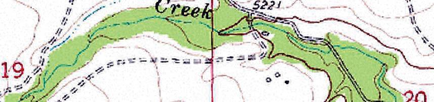
6 ³ Miles 90 GENERAL AREA OF EROSION-RELATED PROBLEMS INCURRED BY THREE DITCH COMPANIES CONVEYING IRRIGATION WATER THROUGH TUNNEL HILL Story PINEY CRUSE DIVERSION LEVEL II STUDY VICINITY MAP FIG. 1
 ³ 0 300 600 1,200 Feet DROP #2 DISTRICT'S PINEY")

")

7 MCDC'S MEAD-COFFEEN DITCH EROSION -RELATED PROBLEMS (SITUATION RECTIFIED IN 2007) ³ ,200 Feet DROP #2 DISTRICT'S PINEY CRUSE PINEY DITCH CRUSE EROSION- DITCH RELATED EROSION PROBLEMS TUNNEL HILL ^_ NORTH PINEY CREEK DIVERSION DAM NORTH PINEY DITCH SECTION NORTH PINEY CREEK DROP #1 ") 194 PDWSC'S PRAIRIE DOG DITCH EROSION-RELATED PROBLEMS (SITUATION PARTIALLY RECTIFIED IN MID-1990s) ") 193 PINEY CRUSE DIVERSION LEVEL II STUDY AREAS WITH EROSION-RELATED PROBLEMS AS IDENTIFIED IN 2000 PRAIRIE DOG WATERSHED MASTER PLAN, LEVEL I STUDY FIG. 2
8 In addition to the $75,000 Level II appropriation, the 2014 Legislature also appropriated $855,000 of Level III funding to be used by the District for the design and construction of water canal improvements and appurtenances. The preliminary design of these water canal improvements and appurtenances was completed in April of The water canal improvements and appurtenances involve conveying irrigation water used by the Ditch Company s members from the North Piney Ditch Section to a point downstream of both Drop #1 and a second drop hereinafter known as Drop #2. Drop #1 is an erosion cut through Tunnel Hill, created many decades ago as a result of the Ditch Company s water eroding through Tunnel Hill as it spilled from the North Piney Ditch Section into the Prairie Dog Creek basin. Drop #2 is another erosion cut through a hillside immediately north of the crest of Tunnel Hill. Figure 4 portrays the locations of the two drops and currently proposed Level III improvements that are utilizing Level III funding (henceforth referred to as the Level III Improvements Project ). Construction of the Level III improvements was originally scheduled for the fall of 2015 and winter of However, due to easement access issues, construction of the Level III improvements has not moved forward as originally planned. 2. EXISTING SYSTEM DESCRIPTION AND INVENTORY While it is obvious that there are differences between the Ditch Company and the District, in many ways it is difficult to differentiate between the two entities when examining the existing conditions and providing recommendations on various alternatives and associated funding. As a result, for purposes of simplicity, henceforth in this 2016 Level II Study the term District will be used throughout to define the project sponsor and entity providing irrigation water when, in actuality, at times the more correct term may be Ditch Company. The District is located in southern Sheridan County, with all lands within its boundaries located north of Story. The District s boundaries and main irrigation ditch (the Piney Cruse Ditch) are depicted in Figure 5. As shown in both Figures 3 and 5, the Piney Cruse Ditch originates at a diversion point located on South Piney Creek. From there, a crossover ditch extends through the community of Story, conveying water from South Piney Creek to North Piney Creek. No major diversions take place in the crossover ditch through Story, although there are approximately 31 small property owners who take minor amounts of water from the crossover ditch in this area for purposes such as lawn and garden watering. There also three other property owners that pump water from the North Piney Ditch Section up to their properties on the top of Tunnel Hill. The group members possess no direct flow right to divert from the crossover ditch. Instead, they own shares of Kearney Lake Reservoir water which is conveyed to and through their properties via the crossover ditch or the North Piney Ditch Section. The District imposes a nominal fee to convey this water. Once water conveyed via the crossover ditch enters North Piney Creek, it commingles with water in this creek and flows downstream to a second diversion point, at which point it is diverted easterly into the North Piney Ditch Section. The North Piney Ditch Section is approximately 1,400 feet long. At the end of the North Piney Ditch Section, water then flows north through Drop #1, then along another section of the Piney Cruse Ditch until it enters Drop #2. Between Drop #1 and Drop #2 is located the first irrigation point of diversion, which pressurizes a water system on the Phillips Ranch. Water then cascades down Drop #2 until it enters another section of the Piney Cruse Ditch, which is much less steep than either Drop #1 s or Drop#2 s channels and, therefore, does not have the erosion problems associated with the two drops. Piney Cruse Diversion Level II Study Executive Summary 2


9 0 ³ 1,000 2,000 4,000 Feet NORTH PINEY CREEK DIVERSION DAM (POINT OF DIVERSION) TU NN CROSSOVER DITCH _ ^ EL HI LL NORTH PINEY DITCH SECTION (POINT OF DIVERSION TO TUNNEL HILL CUT DROP #1) _ ^ SOUTH PINEY CREEK DIVERSION DAM (POINT OF DIVERSION) PINEY CRUSE DIVERSION LEVEL II STUDY LOCATION OF THREE COMPONENTS BEING EVALUATED (SHOWN IN RED) FIG. 3


10


11
12 Once at the end of Drop #2, irrigation water in the Piney Cruse Ditch flows in generally a northerly direction for delivery to the District s other water users. Figure 6 shows the peak-day flows diverted for the Piney Cruse Ditch from , as recorded by the Wyoming State Board of Control (BOC) at the North Piney Creek Diversion. As can be seen, there has been a general downward trend over time in the annual peak-day diversions. According to District officials, the flow in Piney Cruse Ditch downstream of Drop #1 cannot exceed 20 cfs without overtopping, thus the limitation on the amount of flow up to this 20-cfs rate over the past several years. PEAKDAYFLOW(cfs) Figure 6 Historical Diversions at District s North Piney Creek Diversion (Source: Wyoming State Board of Control) 2.1 Structure Inventory and Assessment South Piney Creek Diversion and Related Structures The South Piney Creek Diversion Dam diverts water out of South Piney Creek into the Story crossover ditch. The diversion dam is located in the SE¼SW¼ of Section 13, T53N, R83W. The diversion dam s crest consists generally of large boulders extending into the stream channel for a distance of approximately 23 feet. Due to the large variation in flow rates in South Piney Creek throughout the year, the large boulders are either moved by the creek s force or District personnel (during low flow, in order to increase the water surface elevation in the creek to enable water to flow into the crossover ditch). Overall, the structure is somewhat primitive in nature, although it has generally met the need to divert South Piney Creek water into the crossover ditch. Once water leaves the South Piney Creek diversion, it flows into the crossover ditch, where it travels a distance of approximately 11,600 feet through the community of Story before entering North Piney Creek in the NW¼SW¼ of Section 8, T53N, R83W. Piney Cruse Diversion Level II Study Executive Summary 3
13 2.1.2 North Piney Creek Diversion and Related Structures The North Piney Creek Diversion Dam is located within a braided portion of North Piney Creek. It is located approximately 1,000 feet downstream of the point where water in the crossover ditch from South Piney Creek enters North Piney Creek. The North Piney Creek Diversion Dam is located in the NW¼SW¼ of Section 8, T53N, R83W. As opposed to the South Piney Creek Diversion, the North Piney Creek Diversion Dam has a concrete headwall. This headwall completely spans the channel braid during all but the highest flows. It is two feet thick and contains a notched opening approximately 11 feet wide, with the notched opening showing considerable wear, apparently from its many years of service. Two headgates are located at the diversion dam. Downstream of the dam along the North Piney Ditch Section are both an 8-foot wide measurement flume and a wasteway North Piney Ditch Section As defined previously, the North Piney Ditch Section is that section of the Piney Cruse Ditch which extends from the North Piney Creek Diversion to Drop #1. This ditch section has a length of approximately 1,400 feet prior to entering Drop #1. It conveys water principally during the summer irrigation season, except for runoff flowing directly off of the southerly side of Tunnel Hill. The North Piney Ditch Section generally consists of an unlined trapezoidal channel with a 9-foot bottom width, 1.5:1 sideslopes, a maximum depth of 5, and a slope of approximately 0.55%. There is and has been considerable vegetation, (both living and fallen) along and in some cases in some ditch segments. In addition to the considerable vegetation in some ditch segments, the North Piney Ditch Section has accumulated sediment and other types of debris throughout its years of operation, as mentioned previously. There are also three pumps located along the North Piney Ditch Section which pump irrigation water from the ditch up to properties located on Tunnel Hill. 3. REHABILITATION AND MANAGEMENT PLAN 3.1. Structural Alternatives Several structural alternatives were considered for each of the study s three principal focus areas; i.e., the South Piney Creek Diversion, the North Piney Creek Diversion, and the North Piney Ditch Section. The set of alternatives that is preferred depends in part upon the Level III Improvements Project now attempting to be implemented, which will determine the best means for conveying District water through and immediately north of Tunnel Hill. This 2016 Level II Study and the Level III Improvements Project are mutually dependent, as the location for the Intake Structure #1 for Pipeline #1 associated with the Level III Improvements Project will be determined in that project, while those intake and pipeline locations are being selected keeping in mind the merits and viability of the alternatives discussed in this 2016 Level II Study. Table 1 provides a summary of the various structures evaluated at each of the three principal focus areas, as well as estimate costs to implement them. Piney Cruse Diversion Level II Study Executive Summary 4
14 TABLE 1 SUMMARY OF STRUCTURES EVALUATED Alternative Description Cost Estimate South Piney Creek Diversion Dam and Related Structures Install New Diversion Dam and SPD1 Related Structures at Existing $555,000 Location SPD2 Repair/Upgrade Existing Diversion Dam and Related Structures at Existing Location $413,000 SPD3 SPD4 NPD1 NPD2 NPD3 NPD4 NPD5 NPD6 NPD7 NPDS1 NPDS2 NPDS3 NPDS4 Install New Cross-Vane Diversion Dam and Related Structures at Existing Location Do Nothing No Cost Alternative Rejected North Piney Creek Diversion Dam and Related Structures Relocate to Downstream Location No Cost Alternative Upstream of PDWSC Diversion Dam Rejected Install New Diversion Dam and Related Structures at Existing $1,048,000 Location with SCADA System Install New Diversion Dam and Related Structures at Existing $901,000 Location without SCADA System Install New Diversion Dam and Related Structures Similar to Existing $600,000 Structures at Existing Locations Install New Grouted Rock Diversion $680,000 Dam at Existing Location Repair/Upgrade Existing Diversion No Cost Alternative Dam and Related Structures in Lieu Rejected (maintenance of Replacing Them vs.capital construction) Do Nothing North Piney Ditch Section Install Piping from North Piney Creek Diversion Dam to Tunnel Hill Inlet $476,000 Structure Line Existing Ditch from North Piney Creek Diversion Dam to Tunnel Hill $251,000 Inlet Structure Cleaning Existing Ditch from North Piney Creek Diversion Dam to Tunnel Hill Inlet Structure Do Nothing $25,000 (maintenance vs. capital construction) 3.2 Alternative NPJD - North Piney Creek Joint Diversion Alternative In Conjunction with PDWSC With this alternative, the existing North Piney Creek Diversion Dam and the North Piney Ditch Section would be entirely abandoned, and both District water and PDWSC water would be jointly diverted out of North Piney Creek via the PDWSC s existing diversion dam. It takes advantage of the fact that the existing PDWSC Ditch comes within twenty feet of the North Piney Ditch Section at the point that it currently flows into Drop #1. The PDWSC s existing ditch Piney Cruse Diversion Level II Study Executive Summary 5
15 would convey both Piney Cruse and PDWSC water for approximately 250 feet, at which point a structure would be constructed off of the PDWSC Ditch that would divert Piney Cruse water into a new pipeline (Pipeline #1J) for conveyance through Tunnel Hill and beneath Drop #1. From that point, PDWSC water would be conveyed east via its existing ditch as it has historically done. Alternative NPJD was initially discussed between board members of the District and PDWSC board in May of 2014, but was rejected at that time by the PDWSC board members. However, since that time, further discussions have been held between these parties, and these discussions have resulted in a belief that this concept warrants further investigation. Alternative NPJD is depicted in Figure 7. It varies substantially from previous alternatives involving the North Piney Creek Diversion Dam and the North Piney Ditch Section, because there would no longer be a need for: a North Piney Diversion Dam that would divert irrigation water for solely District water; nor the North Piney Ditch Section in its entirety. The PDWSC ditch s conveyance capacity was measured as part of this study. It has a maximum estimated capacity of 210 cfs between the point of diversion and the proposed Piney Cruse Ditch diversion, assuming a minimum freeboard of six inches between the water surface elevation and the bottom chord of the bridge. Figure 8 is a chart depicting historical North Piney Creek diversions into the North Piney Ditch Section and PDWSC Ditch from the two respective diversions, as measured by the BOC since Note that the sum of the two ditches flows over the past few years is roughly equal to solely the PDWSC Ditch s flows in the early 2000s. This summation underscores the fact that, with time, diversions into both ditches from North Piney Creek are decreasing Peak Flow of Prairie Dog Ditch at Parshall Flume Downstream of North Piney Creek Diversion Peak Flow of Piney Cruse Ditch at Parshall Flume Downstream of North Piney Creek Diversion Sum of Two Ditches' Flows 80 PEAKANNUALFLOW(CFS) Figure 8 Historical Maximum Diversions from North Piney Creek for Piney Cruse and PDWSC Ditches per Board of Control Records Piney Cruse Diversion Level II Study Executive Summary 6


16
17 Pipeline #1 (shown in Figure 4) is part of the Level III Improvements Project, to be constructed through Tunnel Hill for delivery of water to the north side of this hill, eliminating the need for water to flow via the existing Drop #1 route. For Alternative NPJD, Pipeline #1J would be constructed beneath the flow line of Drop #1. (See Figure 9.) At the end of Pipeline #1J, an energy dissipation structure (EDS #1J) would be constructed, which would be within and have an overflow elevation of approximately the same elevation as the Piney Cruse Ditch at this spot. Irrigation water would then flow over the top of EDS #1J and downstream for the District s water users. At this time, the PDWSC has no plans to improve their existing diversion facilities and headgates, in light of the fact that the joint diversion of water does not necessitate enlargement of them. It will be necessary for the District and the PDWSC to negotiate an agreement to utilize these facilities jointly, which will include costs to operate and maintain them between the diversion dam in North Piney Creek and Inlet Structure #1J. All proposed new facilities will be owned by the District. 4. RECOMMENDED ALTERNATIVES AND PROJECT FINANCING In order to assist the District and various funding agencies in determining a fair and equitable financing plan for any of the alternatives identified in Section 3, it is necessary to conduct an economic analysis associated with such a proposed financing plan. This analysis and plan must be adequate to address the needs of not only the WWDC, but also any other possible funding agency requirements. Potential funding sources can have requirements and/or limitations on the types of projects eligible for assistance. Potential funding sources for the improvements discussed in this 2016 Level II Study include the following: WWDC (through its Water Development Account No. II), with possible 67% grants and 33% loans, with terms of 4% for a period of 30 years; the National Resources Conservation Services (NRCS) Environmental Quality Incentives Program (EQIP); NRCS PL-566 Program; the Environmental Protection Agency s Section 319 program (with grants available up to 60% of project costs), which would likely be only available if Alternative NPJD was implemented; the Wyoming Department of Agriculture s Water Quality Grant Program; and various Wyoming Game & Fish Department and U.S. Fish & Wildlife Service Fisheries Enhancement Programs for projects that would benefit the area s fisheries (for projects such as fish passages). 4.1 Recommended Alternatives Although both the South Piney Creek Diversion and North Piney Creek Diversion facilities are included in this 2016 Level II Study, they are in many ways separate projects. This is because neither project s implementation requires the other project to be implemented simultaneously. Additionally, comparison of alternatives for the North Piney Creek Diversion facilities also must consider the proposed Level III Improvements Project, because implementation of Alternative NPJD would totally eliminate the need for both the North Piney Diversion Dam and the North Piney Ditch Section. For this reason, alternative comparisons will be made separately for any South Piney Creek and North Piney Creek improvements. For the comparison of alternatives associated with any North Piney Creek improvements, a combination of the various North Piney Diversion Dam and North Piney Ditch Section improvements will be compared to Alternative NPJD. Piney Cruse Diversion Level II Study Executive Summary 7
18
19 4.2 South Piney Creek Diversion Alternatives Table 1 provided a summary of the various project alternatives considered for the South Piney Creek Diversion Dam and related structures. Costs contained in that summary are based upon the Year 2017, on the assumption that the District will not move forward with any recommended improvements until it completes the proposed Level III Improvements Project (or integrates them into an overall North Piney Creek project as proposed with Alternative NPJD). For the South Piney Creek Diversion Dam and related structures, it is recommended that the District should begin the process of implementing Alternative SPD1 Install New Dam and Related Structures at Existing Location. While this alternative may be the most expensive of the three considered, it would provide the District with the best long-term, reliable solution to divert water into the crossover ditch. Table 2 provides financial information on Alternative SPD1. Recommended Project TABLE 2 PROJECT FINANCING SOUTH PINEY CREEK DIVERSION Total Cost (2017 $) WWDC Grant (67%) NRCS EQIP, WG&FD, and USF&WS Funding, or WWDC Loan (33%) Annual Payment (if WWDC loan: 4% for 30 yrs) SPD1 $555,000 $371,850 $183,150 $10,592 Funding for this project is recommended to be obtained from the WWDC (67% grant) and, to a lesser extent, from possibly the NRCS EQIP program. In addition, and for the fish passage portion of the project only, there is the possibility that a portion of the funding could come from one of the various programs offered by the WG&FD or USF&WS. The degree to which the NRCS can participate using EQIP monies in this project is currently unknown. It could range from the remaining 33% of the project costs to no funding at all. The NRCS could even potentially design the improvements at no cost to the District (using in-house staff), as was the case for the MCDC improvements discussed in the Introduction. If EQIP, WG&FD or USF&WS funding cannot be obtained, the 33% funding could come from a 4%, 30-year loan obtained from the WWDC. 4.3 North Piney Creek Diversion Alternatives Table 1 provided a summary of the various project alternatives considered for the North Piney Creek Diversion Dam and related structures. The table did not, however, include information on Alternative NPJD. Although the District may not need to move forward immediately with improvements to the North Piney Creek Diversion Dam, its related structures and the North Piney Ditch Section, it is imperative that the District address the situations at Drop #1 and Drop #2; i.e., implement the Level III Improvements Project. Unfortunately, due to right-of-way issues discussed previously, construction of the Level III Improvements Project has not been able to move forward. In order to address Drop #1 and Drop #2, the District needs to proceed forward with either: 1. the originally proposed Level III Improvements Project (by somehow securing the necessary right-of-way via negotiations or other legal means); or 2. implementation of Alternative NPJD, which provides an alternative method to deliver water up to and beneath Drop #1 by construction of Inlet Structure#1J, Pipeline #1J, and EDS #1J. Review plans for the Level III Improvements Project were submitted to the District and WWDC staff in April of Included with that submittal was a cost estimate to perform these improvements. That cost estimate showed that the cost for improvements related to Drop #1 was $438,000, and the cost for improvements related to Drop #2 was $415,000. Piney Cruse Diversion Level II Study Executive Summary 8
20 Table 3 provides a cost comparison of the range of alternatives for addressing the North Piney Creek Diversion and related structures, the North Piney Ditch Section, and proceeding forward with either the original Level III Improvements Project or utilizing Alternative NPJD, which modifies the improvements proposed for Drop #1 in the original Level III Improvements Project. Note that this cost comparison includes in each alternative the cost to construct the Drop #2 improvements associated with the Level III Improvements Project. Also included in this table is the estimated annual cost to the District if solely a WWDC loan is used to finance the non-wwdc portion of the various alternatives. As indicated previously, it may be possible to secure funding from the following sources to offset the loan portion of the various alternatives: NRCS EQIP; and Section 319 funding (available for Alternative NPJD only). Not shown in this cost comparison are the Do Nothing alternatives, as it is reasoned that they are not acceptable alternatives and hence do not warrant further consideration. Table 3 concludes that the most cost-effective method for the District to address all of the needs relating to Drop #1, Drop #2, the North Piney Diversion Dam and the North Piney Ditch Section would be to implement Alternative N. Alternative N has an estimated cost of $1,018,000 and includes the following components: Alternative NPJD, which entails the District and the PDWSC jointly utilizing the existing PDWSC diversion dam and headgates, jointly utilizing approximately 315 lineal feet of the existing PDWSC Ditch, and constructing Inlet Structure #1J, Pipeline #1J and EDS #1J. The currently proposed portion of the Level III Improvements Project that constructs the Drop #2 structures. Unfortunately, the $1,018,000 exceeds the amount of the $855,000 appropriation made by the 2014 Wyoming State Legislature to fund the Level III Improvements Project. As a result, it will be necessary to re-approach the Legislature to obtain the necessary additional funding. Although implementation of Alternative N does not provide the District with a new diversion dam and headgate, elimination of the need for the North Piney Diversion Dam, its related facilities, and the North Piney Ditch Section provides not only a capital construction cost advantage, but also shedding of the long-term operational responsibilities for these facilities. With the PDWSC s diversion dam, headgates and ditch now being in acceptable condition, there is reason to believe that they can continue to operate sufficiently for many years. In the long run, the fact that both the District and PDWSC can both one day participate in the cost to eventually replace these facilities should provide a more cost-effective option than continuing to operate with separate facilities. 5. PATH FORWARD The following steps provide a path forward for the District. 1. Negotiate an agreement with the PDWSC to allow use by the District of its diversion dam, headgates and the PDWSC Ditch from the diversion dam to proposed Inlet Structure #1J. 2. Submit a petition to the BOC for a change in point of diversion, and obtain BOC for this change. 3. Request the WWDC to allow use of some of the remaining funds from the 2014 Legislature s $855,000 appropriation (that were originally earmarked for the Level III Improvements Project) to perform the design of Alternative NPJD. As indicated above, the current $855,000 appropriation for the Level III Improvements Project is not sufficient Piney Cruse Diversion Level II Study Executive Summary 9
21 DESIGNATION and Related Structures Ditch Section (Drop #1 structures) (Drop #2 Structures) Cost (67%) WWDC (33 A Construct new North Piney Creek Diversion and related structures (with electricallyoperated motors and SCADA system), pipe North Piney Ditch Section, construct Drop #1 and Drop #2 structures associated with current Level III Improvements Project $1,048,000 $476,000 $438,000 $415,000 $2,377,000 $1,592,590 $784 B C Construct new North Piney Creek Diversion and related structures (with electricallyoperated motors and SCADA system), line North Piney Ditch Section, construct Drop #1 and Drop #2 structures associated with current Level III Improvements Project Construct new North Piney Creek Diversion and related structures (with electricallyoperated motors and SCADA system), clean North Piney Ditch Section, construct Drop #1 and Drop #2 structures associated with current Level III Improvements Project $1,048,000 $251,000 $438,000 $415,000 $2,152,000 $1,441,840 $710 $1,048,000 $25,000 $438,000 $415,000 $1,926,000 $1,290,420 $635 D Construct new North Piney Creek Diversion and related structures (withoout electrically-operated motors and SCADA system), pipe North Piney Ditch Section, construct Drop #1 and Drop #2 structures associated with current Level III Improvements Project $901,000 $476,000 $438,000 $415,000 $2,230,000 $1,494,100 $735 E Construct new North Piney Creek Diversion and related structures (withoout electrically-operated motors and SCADA system), line North Piney Ditch Section, construct Drop #1 and Drop #2 structures associated with current Level III Improvements Project $901,000 $251,000 $438,000 $415,000 $2,005,000 $1,343,350 $661 F Construct new North Piney Creek Diversion and related structures (withoout electrically-operated motors and SCADA system), clean North Piney Ditch Section, construct Drop #1 and Drop #2 structures associated with current Level III Improvements Project $901,000 $25,000 $438,000 $415,000 $1,779,000 $1,191,930 $587 H J Construct New Diversion Dam and Related Structures similar to existing structures at existing locations, pipe North Piney Ditch Section, construct Drop #1 and Drop #2 structures associated with current Level III Improvements Project Construct New Diversion Dam and Related Structures similar to existing structures at existing locations, line North Piney Ditch Section, construct Drop #1 and Drop #2 structures associated with current Level III Improvements Project Construct New Diversion Dam and Related Structures similar to existing structures at existing locations, clean North Piney Ditch Section, construct Drop #1 and Drop #2 structures associated with current Level III Improvements Project $600,000 $476,000 $438,000 $415,000 $1,929,000 $1,292,430 $636 $600,000 $251,000 $438,000 $415,000 $1,704,000 $1,141,680 $562 $600,000 $25,000 $438,000 $415,000 $1,478,000 $990,260 $487 K Install new grouted rock diversion dam at existing location, pipe North Piney Ditch Section, construct Drop #1 and Drop #2 structures associated with current Level III Improvements Project $680,000 $476,000 $438,000 $415,000 $2,009,000 $1,346,030 $662 L Install new grouted rock diversion dam at existing location, line North Piney Ditch Section, construct Drop #1 and Drop #2 structures associated with current Level III Improvements Project $680,000 $251,000 $438,000 $415,000 $1,784,000 $1,195,280 $588 M Install new grouted rock diversion dam at existing location, clean North Piney Ditch Section, construct Drop #1 and Drop #2 structures associated with current Level III Improvements Project $680,000 $25,000 $438,000 $415,000 $1,558,000 $1,043,860 $514 N District and PDWSC jointly utilize existing PDWSC diversion dam, headgates and approximately 315 LF of existing PDWSC Ditch, construct Inlet Structure #1J, Pipeline #1J and EDS #1J, construct Drop #2 structures associated with current Level III Improvements Project $0 $0 $603,000 $415,000 $1,018,000 $682,060 $335 I
22 to fund Alternative N as modified. However, in light of the fact that Alternative N is more cost-effective than the sum of the current Level III Improvements Project plus North Piney Diversion Dam and North Piney Ditch Section improvements, it is believed that the WWDC could justify authorization of the design for this project component to move forward. 4. Apply for an additional $163,000 (= $1,018,000 - $855,000) to allow for total funding of Alternative N. If the WWDC allows for design of Alternative NPJD at this time, this will allow for construction to be performed in the fall of 2017 if the 2017 Legislature provides the additional funding. The application for the additional $163,000 should be made to the WWDC in the fall of Complete design of Alternative NPJD, and incorporate this with the previously-designed Level III Improvements Project components that provide for a solution to the Drop #2 situation. As part of this design effort, notify the owners of the irrigation pumps for the three Tunnel Hill property owners who currently pump water from the North Piney Ditch Section that this ditch will no longer be available for their use. It appears at this time that the most expedient method for them to continue to obtain irrigation water would be for them to relocate their pumping systems so that they would pump water out of the PDWSC Ditch. 6. Work with the NRCS to obtain possible EQIP funding and DEQ to obtain possible EPA Section 319 funding for the recommended Alternative N improvements. Procurement of these additional funds will reduce the District s financial obligation by paying a share of the non-wwdc portion of the recommended improvements. 7. Secure the additional right-of-way necessary to construct Alternative N. Prior to commencing with negotiations for the additional right-of-way, secure an appraised value for the right-of-way to determine a fair price to offer. Compensation for rights-ofway which are based upon an appraised value are eligible for WWDC funding. 8. Construct Alternative N, beginning in the fall of Construction should be complete to allow for use of the Alternative N improvements in the spring of Once construction of Alternative N is underway, submit an application to the WWDC for funding of the design and construction associated with SPD1. The application should be made for consideration by the 2018 Wyoming State Legislature. (It would be unwise to request funding for the SPD1 improvements and the necessary additional funding to implement Alternative N at the same time.) 10. Work with the NRCS to obtain possible EQIP funding for the recommended SPD1 improvements. Also work with the WG&FD and USF&WS to obtain funding for the recommended SPD1 improvements that pertain to fish passage. Procurement of these additional funds will reduce the District s financial obligation by paying a share of the non-wwdc portion of the recommended improvements. 11. Once funding is obtained from the Wyoming State Legislature in 2018, enter into an engineering design contract for SPD1. Plans, specifications and right-of-way access would have to be completed and obtained promptly so that construction could begin in the late fall of If this schedule can be met, SPD1 could be available for use in the spring of Piney Cruse Diversion Level II Study Executive Summary 10
Re: Survey of constructed cross section per Restoration Framework on Wind River, Fremont County, WY
 1-11-17 LeClair Irrigation District 1418 Cowboy Lane Riverton, WY 82501 (307) 856-4018 Re: Survey of constructed cross section per Restoration Framework on Wind River, Fremont County, WY Dear Mr. Hoelzen,
ATTACHMENT H TACOMA HYDROELECTRIC PROJECT DESCRIPTION OF PROJECT FEATURES
 ATTACHMENT H TACOMA HYDROELECTRIC PROJECT DESCRIPTION OF PROJECT FEATURES The Tacoma Hydroelectric Project is located about 20 miles north of Durango, Colorado, on a high intermountain plateau west of
SECTION 2 GENERAL REQUIREMENTS
 SECTION 2 GENERAL REQUIREMENTS 2-1 ENGINEER REQUIRED: All plans and specifications for Improvements which are to be accepted for maintenance by the County and private, on-site drainage and grading shall
Hillside & Foothills Development Application
 Hillside & Foothills Development Application This box for office use only File #: Cross Referenced File(s): Fee: Zone(s): Are Pre-Application materials attached? Yes No This application is a request to
B422 - PRECAST REINFORCED CONCRETE BOX CULVERTS AND BOX SEWERS - OPSS 422
 B422 - PRECAST REINFORCED CONCRETE BOX CULVERTS AND BOX SEWERS - OPSS 422 422.1 GENERAL The work under these tender items consists of the fabrication and installation in open cut of precast reinforced
List of Figures. List of Forms
 City of Columbia Engineering Regulations PART 1: SUBMISSION OF PLANS Table of Contents Paragraph Description Page No. 1.1 General 1-1 1.2 Engineer s Report 1-1 1.3 Plans 1-3 1.4 Revisions to Approved Plan
Conceptual, Preliminary and Final Site Plan Review in Holladay City
 Conceptual, Preliminary and Final Site Plan Review in Holladay City The City of Holladay incorporated in December, 1999 and adopted its own zoning ordinance in May, 2000. All land use decisions are made
Town of Apex, North Carolina
 POND DRAINAGE PLAN APPLICATION Town of Apex, North Carolina POND DRAINAGE PLAN APPLICATION: Applications are due by 12:00 pm on the first business day of each month. Please see the Minor Site Plan Schedule
Technical Memorandum ECO-7
 To: Woody Frossard, TRWD From: Bob Brashear, CDM This document is released for the purpose of interim review under the authority of Robert Brashear, P.E., TX license 80771 on 21-Mar-2005. It is not to
MAJOR GRADING PLAN CHECKLIST
 MAJOR GRADING PLAN CHECKLIST PUBLIC WORKS DEPARTMENT / ENGINEERING DIVISION 8130 Allison Avenue, La Mesa, CA 91942 Phone: (619) 667-1166 Fax: (619) 667-1380 Grading plans shall address both rough grading
REPORT TO COUNCIL DORWICK DITCH PETITION REHABILITATION PROJECT JUNE 8, 2016
 REPORT TO COUNCIL DORWICK DITCH PETITION REHABILITATION PROJECT JUNE 8, 2016 Based on a preliminary study by Euthenics, Inc. www.euthenics_inc.com 1 SECTION I GENERAL INFORMATION AND EXISTING CONDITIONS
Authorized Agent: City of Manassas Check List Attached: Contact: Address: Phone Number: Fax Number: Developer s Name: Phone Number:
 CITY OF MANASSAS DEPARTMENT OF COMMUNITY DEVELOPMENT DEVELOPMENT SERVICES DIVISION 9027 Center Street Room 201 Manassas, Virginia, 20110 Phone: 703-257-8278 Fax: 703-257-5831 Application Date: APPLICANT
City of Massillon Site Plan Checklist
 City of Massillon Site Plan Checklist The following information MUST be included with all Site Plans submitted for review and processing in order to constitute a complete Site Plan Package. Incomplete
B.2 MAJOR SUBDIVISION PRELIMINARY PLAN CHECKLIST
 B.2 MAJOR SUBDIVISION PRELIMINARY PLAN CHECKLIST YES* GENERAL SUBMISSION ITEMS Does the submission include: 1. Thirteen (13) copies of completed Application Form? 2. Thirteen (13) copies of the Preliminary
CITY OF TUMWATER 555 ISRAEL RD. SW, TUMWATER, WA (360)
") CITY OF TUMWATER 555 ISRAEL RD. SW, TUMWATER, WA 98501 (360) 754-4180 Email: cdd@ci.tumwater.wa.us WATER-SEWER-STREET-STORM (IN CITY) Submittal Checklist TUM - RCVD BY DATE STAMP APPLICANT INFORMATION
CITY OF TUMWATER 555 ISRAEL RD. SW, TUMWATER, WA 98501 (360) 754-4180 Email: cdd@ci.tumwater.wa.us WATER-SEWER-STREET-STORM (IN CITY) Submittal Checklist TUM - RCVD BY DATE STAMP APPLICANT INFORMATION
PUBLIC ART PROCUREMENT GUIDELINES
 PUBLIC ART PROCUREMENT GUIDELINES A. Preliminary A. In 1983, the Minnesota State Legislature enacted the law forming the basis for the Minnesota Percent for Art in Public Places program. This legislation
CHAPTER 11 PRELIMINARY SITE PLAN APPROVAL PROCESS
 CHAPTER 11 PRELIMINARY SITE PLAN APPROVAL PROCESS 11.01.00 Preliminary Site Plan Approval 11.01.01 Intent and Purpose 11.01.02 Review 11.01.03 Application 11.01.04 Development Site to be Unified 11.01.05
AVISTA CORPORATION ' FEDERAL STORAGE CLAIM A-1
 AVISTA CORPORATION 2126.5' FEDERAL STORAGE CLAIM A-1 AVISTA CORPORATION 2126.5' FEDERAL STORAGE CLAIM EXHIBIT A-2 AVISTA CORPORATON 2126.5' FEDERAL STORAGE CLAIM EXHIBIT A-3 AVISTA CORPORATION 2126.5'
Anne Arundel County Dept. of Inspections and Permits Water Sewer Plan Checklist
 Project Name Project Number Engineer Plans are to be designed based on the standards set forth in the Anne Arundel County Design Manual Standards and Specifications, and all other manuals as stipulated
KKR S. 6 th St. to I-94 Bridge Project Location. Expanded Floodplains
 Kinnickinnic River Watercourse Rehabilitation Early Out Project Achieving Multiple Design Objectives Thomas R. Sear, PE, CFM Short Elliott Hendrickson Patrick C. Elliott, PE Milwaukee Metropolitan Sewerage
CONVEYANCE PIPELINE AND PUMP STATION
 SCOPE OF WORK CONVEYANCE PIPELINE AND PUMP STATION The purpose of this scope of work is to provide engineering services to revise and complete the design of the RUWAP pipeline and 5th Avenue Pump Station
8(A) CONTRACTING, MENTOR-PROTÉGÉ PROGRAM, & JOINT VENTURES. March 9, 2010 William T. Welch
 CONTRACTING, MENTOR-PROTÉGÉ PROGRAM, & JOINT VENTURES. March 9, 2010 William T. Welch") 8(A) CONTRACTING, MENTOR-PROTÉGÉ PROGRAM, & JOINT VENTURES March 9, 2010 William T. Welch THE AUDIENCE How many individuals here represent companies that are now or have been in the 8(a) program? How many
8(A) CONTRACTING, MENTOR-PROTÉGÉ PROGRAM, & JOINT VENTURES March 9, 2010 William T. Welch THE AUDIENCE How many individuals here represent companies that are now or have been in the 8(a) program? How many
ARTICLE 3: WATERSHED MANAGEMENT PERMIT REQUIREMENTS AND SUBMITTALS
 ARTICLE 3: WATERSHED MANAGEMENT PERMIT REQUIREMENTS AND SUBMITTALS Introduction This section provides guidance on the submittal requirements for a development to obtain a Watershed Management Permit from
CONSULTANT ACCREDITATION SCHEME SEWER DESIGN
 CONSULTANT ACCREDITATION SCHEME SEWER DESIGN DRAWING CRITERIA AND CHECKLIST Produced by SA Water Corporation Asset Management Group June 2013 Land Developer Agreements Contact Information Details Sharyn
Section 1. Introduction
 Overview of Manual Acknowledgements i x Section 1. Introduction 1.0 Overview of Section 1 1-1 1.1 The GESC and DESC Permits 1-2 1.2 Reasons for the GESC and DESC Permits 1-2 1.3 Legislative Mandate 1-3
Sec Radio, television, satellite dish and communications antennas and towers.
 Se 2106. - Radio, television, satellite dish and communications antennas and towers. (a) (b) (c) (d) No guy wires or other accessories associated with any antenna or tower shall cross, encroach, or otherwise
BRASELTON WATER AND WASTEWATER DEPARTMENT CONSTRUCTION PLAN REVIEW CHECKLIST May 2006
 Project Name: BRASELTON WATER AND WASTEWATER DEPARTMENT CONSTRUCTION PLAN REVIEW CHECKLIST May 2006 Phase: Unit: # Lots: Development Type (residential, commercial, industrial, etc.) Braselton Project No.
Policy on Patents (CA)
") RESEARCH Effective Date: Date Revised: N/A Supersedes: N/A Related Policies: Policy on Copyright (CA) Responsible Office/Department: Center for Research Innovation (CRI) Keywords: Patent, Intellectual
RESEARCH Effective Date: Date Revised: N/A Supersedes: N/A Related Policies: Policy on Copyright (CA) Responsible Office/Department: Center for Research Innovation (CRI) Keywords: Patent, Intellectual
DEVELOPMENT PLAN CHECKLIST
 Project Identification Information: DEVELOPMENT PLAN CHECKLIST 1.0 GENERAL 1.1 Additional information as required by specific Land Use 1.2 All sheets to include sheet number ( of ) 1.3 Seal and signature
SUBMITTAL REQUIREMENTS RCV D REJECT PENDING
 1 of 5 SUBMITTAL REQUIREMENTS RCV D REJECT PENDING 1. General Information. 1.1 Applicant s name, address and contact numbers. 1.2 Project name, type, address and legal description of the property. 1.3
Recommended Changes to the Public Hearing Draft Zoning Ordinance
 DATE: December 6, 2016 TO: Village of Oak Park FROM: Arista Strungys SUBJECT: Recommended Changes Recommended Changes to the Public Hearing Draft Zoning Ordinance ZONING MAP» Edit to remove right-of-way
Mystic Lake Hydroelectric Project FERC Project Number Year Bald Eagle Monitoring Summary Report Public
 Mystic Hydroelectric Project FERC Project Number 2301 3-Year Bald Eagle Monitoring Summary Report 2010-2013 Public 2013 by PPL Montana, LLC. ALL RIGHTS RESERVED Submitted to: Federal Energy Regulatory
Peters Township Sanitary Authority 3244 Washington Road McMurray, PA 15317
 3244 Washington Road McMurray, PA 15317 (724) 941-6709 Appendix C Developer Information PETERS TOWNSHIP SANITARY AUTHORITY SEWER USE RULES AND REGULATIONS APPENDIX C Procedures and Requirements for Land
Anne Arundel County Dept. of Inspections and Permits Storm Drain Checklist
 Project Name Project Number Engineer Plans are to be designed based on the standards set forth in the Anne Arundel County Design Manual Standards and Specifications, and all other manuals as stipulated
SECTION III SUBMITTALS AND APPROVALS
 SECTION III SUBMITTALS AND APPROVALS In order to expedite the approval process of new water distribution system and sanitary sewer collection system extensions, the Hilton Head No. 1 Public Service District
Technology transactions and outsourcing deals: a practitioner s perspective. Michel Jaccard
 Technology transactions and outsourcing deals: a practitioner s perspective Michel Jaccard Overview Introduction : IT transactions specifics and outsourcing deals Typical content of an IT outsourcing agreement
Bestall Collaborative Limited Planning Environment Construction Management Development
 November 18, 2017 Bestall Collaborative Limited Lori Hight, AICP, Senior Planner City Development Department City of Thornton City Hall 9500 Civic Center Drive Thornton, Colorado 80229-4326 RE: River Valley
Public Works City of Lebanon, Tennessee; Department of Public Works
 SECTION 1 GENERAL 1. DEFINITIONS Public Works City of Lebanon, Tennessee; Department of Public Works City City of Lebanon, Wilson County, Tennessee City Engineer Employed by the City of Lebanon, Registered
CITY OF OLIVETTE SITE PLAN AND COMMUNITY DESIGN REVIEW INFORMATION PACKET
 CITY OF OLIVETTE SITE PLAN AND COMMUNITY DESIGN REVIEW INFORMATION PACKET THE FOLLOWING PACKET CONTAINS: PETITION FOR NONRESIDENTIAL DEVELOPMENT SITE PLAN AND COMMUNITY DESIGN REVIEW SCHEDULE OF DATES
CITY OF BEVERLY HILLS Department of Public Works and Transportation Civil Engineering Division STORM DRAIN IMPROVEMENT PLAN REVIEW CHECKLIST
 CITY OF BEVERLY HILLS Department of Public Works and Transportation Civil ing Division STORM DRAIN IMPROVEMENT PLAN REVIEW CHECKLIST The following checklist consists of the minimum requirements for preparation
SUBMITTAL REQUIREMENTS FOR USE PROCESS III OR PROCESS IV
 COMMUNITY DEVELOPMENT DEPARTMENT 33325 8 th Avenue South Federal Way WA 98003 253-835-2607; Fax 253-835-2609 www.cityoffederalway.com SUBMITTAL REQUIREMENTS FOR USE PROCESS III OR PROCESS IV USE PROCESS
SECTION 100 PRELIMINARY CONSIDERATIONS & INSTRUCTIONS
 SECTION 100 PRELIMINARY CONSIDERATIONS & INSTRUCTIONS 101 General 102 Submittal Requirements A. Initial Submittal B. Second Submittal 103 Plan Requirements A. Subdivisions B. Site Plans 104 Approval of
SITE PLAN Application Packet (Required For All Non-Residential Development Projects)
") SITE PLAN Application Packet (Required For All Non-Residential Development Projects) Community Development Department 90 North Main Street, Tooele, UT 84074 (435) 843-2130 Fax (435) 843-2139 Dear Applicant,
SITE PLAN Application Packet (Required For All Non-Residential Development Projects) Community Development Department 90 North Main Street, Tooele, UT 84074 (435) 843-2130 Fax (435) 843-2139 Dear Applicant,
On-Site Sewage Disposal Application Packet
 On-Site Sewage Disposal Application Packet This packet of materials should include all you need to begin your residential or commercial application for on-site sewage disposal: Site feasibility Installation
ADMINISTRATIVE DESIGN REVIEW Information
 Information The following information summarizes the City s Administrative Design Review (ADR) provisions. If you have any questions, please contact the Planning and Development Services Department at
MILL HILL ARTS VILLAGE
 OWNER CIVIL ENGINEER MACON-BIBB URBAN DEVELOPMENT AUTHORITY ALEX MORRISON, EXECUTIVE DIRECTOR 200 CHERRY STREET, SUITE 300 MACON, GA 31201 OFFICE PHONE : (478) 803-2402 TRIPLE POINT ENGINEERING DAN WALLACE,
Minor Site Plan Review Process
 Minor Site Plan Review Process Pre-Application Conference Community Meeting (optional) Submit Application Determination of Completeness Staff Report (optional) Technical Review Committee Decision Notice
The Board of County Road Commissioners of the County of Kent met in the. The regular meeting was called to order by Commissioner Rambo, Chairman
 1500 Scribner Avenue, NW Grand Rapids, MI 49504 The Board of County Road Commissioners of the County of Kent met in the Road Commission Offices. The regular meeting was called to order by Commissioner
DOCUMENT MINIMUM CONSTRUCTION DRAWING REQUIREMENTS FOR PRELIMINARY REVIEW/APPROVAL 1.2. GALVESTON COUNTY CONSOLIDATED DRAINAGE DISTRICT (GCCDD)
") DOCUMENT 01105 FOR PRELIMINARY REVIEW/APPROVAL PART I: SUBMITTAL 1.1 CITY OF FRIENDSWOOD (COF) A. Submit four (4) copies of drawings. B. Submit by 5:00 PM a minimum of fourteen calendar days (14 cd) prior
DOCUMENT 01105 FOR PRELIMINARY REVIEW/APPROVAL PART I: SUBMITTAL 1.1 CITY OF FRIENDSWOOD (COF) A. Submit four (4) copies of drawings. B. Submit by 5:00 PM a minimum of fourteen calendar days (14 cd) prior
APPLICATION FOR PLANNED UNIT DEVELOPMENT (PUD) DEVELOPMENT PLAN
 DEVELOPMENT PLAN") 209 S. Main Street Marysville, Ohio 43040 Phone: (937) 645-7350 Fax: (937) 645-7351 www.marysvilleohio.org APPLICATION FOR PLANNED UNIT DEVELOPMENT (PUD) DEVELOPMENT PLAN *** IMPORTANT INFORMATION ~ Please
209 S. Main Street Marysville, Ohio 43040 Phone: (937) 645-7350 Fax: (937) 645-7351 www.marysvilleohio.org APPLICATION FOR PLANNED UNIT DEVELOPMENT (PUD) DEVELOPMENT PLAN *** IMPORTANT INFORMATION ~ Please
Somerset Homeowners Association Board Meeting Minutes Tuesday, July 12, 2011
 Somerset Homeowners Association Board Meeting Minutes Tuesday, July 12, 2011 Board Members: Mike Atkins, Dave Edwards, Ajay Sreenivas Property Manager: Al Orendorff, Legal Mark Biddison Community: Garret
California State University, Northridge Policy Statement on Inventions and Patents
 Approved by Research and Grants Committee April 20, 2001 Recommended for Adoption by Faculty Senate Executive Committee May 17, 2001 Revised to incorporate friendly amendments from Faculty Senate, September
Minimum Drawing & Electronic Submittal Requirements For Record Drawings /As-Builts
 Minimum Drawing & Electronic Submittal Requirements For Record Drawings /As-Builts PUBLIC WORKS ENGINEERING DEPARTMENT Revised: February 1, 2017 MINIMUM DRAWING REQUIREMENTS A. GENERAL PLAN REQUIREMENTS:
1.1 GENERAL RECORD DRAWING REQUIREMENTS
 Page 1 of 5 VILLAGE OF ROMEOVILLE RECORD DRAWINGS CHECKLIST PART I GENERAL Record drawings are required to provide a means of schematic verification that the intent of the approved engineering design has
LAW ON TECHNOLOGY TRANSFER 1998
 LAW ON TECHNOLOGY TRANSFER 1998 LAW ON TECHNOLOGY TRANSFER May 7, 1998 Ulaanbaatar city CHAPTER ONE COMMON PROVISIONS Article 1. Purpose of the law The purpose of this law is to regulate relationships
APPLICATION FOR SITE PREPARATION PERMIT
 Engineering Division 550 Landa Street New Braunfels, Texas 78130 (830) 221-4020 1. Subdivision/Plat Name: Location Description/ Nearest Intersection: Acreage: APPLICATION FOR SITE PREPARATION PERMIT No.
CHECKLIST PRELIMINARY SUBDIVISION AND PRELIMINARY SITE PLAN
 N/A Waiver (1) Four (4) copies of application form. (2) Fifteen (15) copies of plan (3) Subdivision/site plan application fee & professional review escrow deposit (4) Variance application fee & professional
State of New Jersey Chris Christie, Governor. Dept. of Environmental Protection Bob Martin, Commissioner
 Cape May Beach 2016/2017 Renourishment Cape May Inlet to Lower Township & Lower Cape May Meadows Cape May Point Cape May County, New Jersey New Jersey Department of Environmental Protection Engineering
SUMMIT COUNTY PLANNING AND ENGINEERING DEPARTMENT
 SUMMIT COUNTY PLANNING AND ENGINEERING DEPARTMENT SINGLE-FAMILY SITE PLAN INFORMATION PACKET GENERAL INFORMATION This information packet explains how your application for a single-family site plan will
Facility Services Subgroup Preface for Divisions 21` through 28
 Facility Services Subgroup Preface for Divisions 21` through 28 1.1 EXECUTIVE SUMMARY A. This document provides standards for the Consultants and Contractors producing mechanical and electrical design
SANITARY SEWER SYSTEM ADMINISTRATIVE STANDARDS A.1 SANITARY SEWER SYSTEM PLAN SUBMITTAL PROCEDURES AND GENERAL REQUIREMENTS
 SANITARY SEWER SYSTEM ADMINISTRATIVE STANDARDS A.1 SANITARY SEWER SYSTEM PLAN SUBMITTAL PROCEDURES AND GENERAL REQUIREMENTS All plans for sanitary sewer main extensions, improvements and modifications
Site Plan/Building Permit Review
 Part 6 Site Plan/Building Permit Review 1.6.01 When Site Plan Review Applies 1.6.02 Optional Pre- Application Site Plan/Building Permit Review (hereafter referred to as Site Plan Review) shall be required
A. Dewatering observation wells are part of dewatering allowance.
 SECTION 312319 - DEWATERING PART 1 - GENERAL 1.1 RELATED DOCUMENTS A. Drawings and general provisions of the Contract, including General and Supplementary Conditions and Division 01 Specification Sections,
2015 / 2016 STATUS REPORT IRRIGATION REHABILITATION PROGRAM
 2015 / 2016 STATUS REPORT IRRIGATION REHABILITATION PROGRAM Agriculture and Forestry IRRIGATION REHABILITATION PROGRAM 2015/2016 STATUS REPORT Prepared by Irrigation Secretariat Lethbridge, Alberta January
Application Submittal Checklist for a BASIC USE PERMIT (BUP) Planning & Development Department Planning Division
 Planning & Development Department Planning Division") Application Submittal Checklist for a BASIC USE PERMIT (BUP) APPLICABILITY. This checklist should be used when submitting an application for a Basic Use Permit. When is a Basic Use Permit required? Section
Application Submittal Checklist for a BASIC USE PERMIT (BUP) APPLICABILITY. This checklist should be used when submitting an application for a Basic Use Permit. When is a Basic Use Permit required? Section
Grading, Erosion and Sediment Control (GESC) Checklist
 Checklist") Development Services Department 100 N. Wilcox Street, Castle Rock CO 80104 Planner of the Day 303-660-1393 Grading, Erosion and Sediment Control (GESC) Checklist A complete Grading, Erosion and Sediment
Development Services Department 100 N. Wilcox Street, Castle Rock CO 80104 Planner of the Day 303-660-1393 Grading, Erosion and Sediment Control (GESC) Checklist A complete Grading, Erosion and Sediment
WGA LOW BUDGET AGREEMENT
 WGA LOW BUDGET AGREEMENT ( Company ) has read the Writers Guild of America ( WGA ) Low Budget Agreement (the Low Budget Agreement ). Company desires to produce (the Picture ) under the Low Budget Agreement.
F98-3 Intellectual/Creative Property
 F98-3 (A.S. 1041) Page 1 of 7 F98-3 Intellectual/Creative Property Legislative History: At its meeting of October 5, 1998, the Academic Senate approved the following policy recommendation presented by
Plan Preparation Checklist
 Appendix D Plan Preparation Checklist It is the responsibility of the Designer to complete and submit this checklist along with all required drawings for OUC (EFP) Review. All drawings submitted for OUC
Bald Eagle Annual Report February 1, 2016
 Bald Eagle Annual Report 2015 February 1, 2016 This page intentionally blank. PROJECT SUMMARY Project Title: Bald Eagle HCP Monitoring Subject Area: Habitat Conservation Plan (HCP) monitoring Date initiated:
State College Area School District
 State College Area School District The following is a guideline for project design submittals to the Facility Committee of the State College Area School District. During the design process the committee
A Bill Regular Session, 2007 HOUSE BILL 1589
 Stricken language would be deleted from and underlined language would be added to the law as it existed prior to this session of the General Assembly. Act of the Regular Session State of Arkansas th General
PLANNING AND DEVELOPMENT
 OVERVIEW Effective January 1, 1992 all applications for multi-family residential and all non-residential building permits require site plan approval before permit issuance. All new developments and existing
SECTION DEWATERING TANKAGE PART 1 - GENERAL 1.1 RELATED DOCUMENTS
 SECTION 31 23 19 - DEWATERING TANKAGE PART 1 - GENERAL 1.1 RELATED DOCUMENTS A. Drawings and general provisions of the Contract, including General and Supplementary Conditions and Division 1 Specification
SECTION CONTRACTOR SUBMITTALS. A. All submittals by the CONTRACTOR shall be submitted to the ENGINEER.
 SECTION 01300 - PART 1 - GENERAL 1.1 GENERAL A. All submittals by the CONTRACTOR shall be submitted to the ENGINEER. B. Unless otherwise noted, within 14 days after the date of commencement as stated in
The following draft Agreement supplements, but does not replace, the MOU by and between the Bureau of Land Management (BLM) and the California
 and the California") The following draft Agreement supplements, but does not replace, the MOU by and between the Bureau of Land Management (BLM) and the California Department of Fish and Wildlife (CDFW), which was entered
The following draft Agreement supplements, but does not replace, the MOU by and between the Bureau of Land Management (BLM) and the California Department of Fish and Wildlife (CDFW), which was entered
Scope of Services. Project management tasks are estimated based upon anticipated project duration of 52 weeks.
 Scope of Services Project Understanding The City of Sparks (City) has also requested the HDR Engineering, Inc. (HDR) provided limited shop drawing review and periodic observation during construction and
Minor Site Plan Application
 Section 496-11.3.6 of the City Code: Minor Site Plan Review allows for review of the site design of routine development applications that are eligible to be processed administratively. Procedure 1. If
UNITED STATES OF AMERICA BEFORE THE FEDERAL ENERGY REGULATORY COMMISSION
 UNITED STATES OF AMERICA BEFORE THE FEDERAL ENERGY REGULATORY COMMISSION Exelon Corporation ) ) Docket No. EC05-43-000 Public Service Enterprise Group, Inc. ) Affidavit of Richard W. LeLash on behalf of
SECTION DEWATERING PART 1 - GENERAL 1.1 RELATED DOCUMENTS
 SECTION 312319 - DEWATERING PART 1 - GENERAL 1.1 RELATED DOCUMENTS A. Drawings and general provisions of the Contract, including General and Supplementary Conditions and Division 01 Specification Sections,
VARIANCE APPLICATION (NO SITE PLAN OR SUBDIVISION)
") VARIANCE APPLICATION (NO SITE PLAN OR SUBDIVISION) 190-66. General procedure for completeness review. A. In order to be determined complete for review by the Board, all of the required information must
VARIANCE APPLICATION (NO SITE PLAN OR SUBDIVISION) 190-66. General procedure for completeness review. A. In order to be determined complete for review by the Board, all of the required information must
FREMONT COUNTY. APPLICATION FOR ZONE CHANGE #2 USE DESIGNATION PLAN (Requires Subsequent Approval of ZC #2 Final Designation Plan) 1.
 1.") FREMONT COUNTY APPLICATION FOR ZONE CHANGE #2 USE DESIGNATION PLAN (Requires Subsequent Approval of ZC #2 Final Designation Plan) 1. Project Name: 2. Applicant: Address: City: State: Zip Code: Telephone
FREMONT COUNTY APPLICATION FOR ZONE CHANGE #2 USE DESIGNATION PLAN (Requires Subsequent Approval of ZC #2 Final Designation Plan) 1. Project Name: 2. Applicant: Address: City: State: Zip Code: Telephone
MODULE 5 ACCOUNTING FOR EXPLORATION, DRILLING AND DEVELOPMENT COSTS
 MODULE 5 ACCOUNTING FOR EXPLORATION, DRILLING AND DEVELOPMENT COSTS OUTLINES Preparation for Development and Drilling Accounting for Development Costs Controversial Issues in Accounting for Exploration
ACSA PLAN REVIEW CHECKLIST (Guideline Only) (4) Standard water and sewer general plan notes (attached).
 (4) Standard water and sewer general plan notes (attached).") ACSA PLAN REVIEW CHECKLIST (Guideline Only) Revised: December 3, 2015 General (1) Proper Title (2) Vicinity map on first sheet. (3) Date and latest plan revision. (4) Standard water and sewer general plan
ACSA PLAN REVIEW CHECKLIST (Guideline Only) Revised: December 3, 2015 General (1) Proper Title (2) Vicinity map on first sheet. (3) Date and latest plan revision. (4) Standard water and sewer general plan
GEO-SLOPE International Ltd, Calgary, Alberta, Canada Relief Well Spacing
 1 Introduction Relief Well Spacing Relief wells are commonly installed on the downstream side of an earth dam to control the seepage and pore-pressures (e.g. levee; Figure 1). A key design requirement
LARAMIE COUNTY PLANNING & DEVELOPMENT OFFICE 3966 Archer Pkwy Cheyenne, WY Phone (307) Fax (307)
 Fax (307)") 3966 Archer Pkwy Cheyenne, WY 82009 planning@laramiecounty.com Phone (307) 633-4303 Fax (307) 633-4616 SITE PLAN REVIEW PROCESS 1. Pre-Application Meeting: The applicant shall meet with a Laramie County
3966 Archer Pkwy Cheyenne, WY 82009 planning@laramiecounty.com Phone (307) 633-4303 Fax (307) 633-4616 SITE PLAN REVIEW PROCESS 1. Pre-Application Meeting: The applicant shall meet with a Laramie County
TO: FROM SUBJECT: SRBA Jon Albright Technical Memorandum on Hydrologic Yields PROJECT: Sulphur River Basin Feasibility Study DATE: 08/26/2014 CC:
 593 Summerhill Rd Texarkana, Texas 7553 93-838-8533 fax 93-832-47 TO: FROM SUBJECT: PROJECT: SRBA Jon Albright Technical Memorandum on Hydrologic Yields Sulphur River Basin Feasibility Study DATE: 8/26/214
Town of Westlake Construction Plans Review Checklist
 CONSTRUCTION PLANS CONTENTS All Drawings 24 x 36 Cover Sheet Final Plat Site Plan Demolition Plan Utility Plan Drainage Area Map and Calculations Paving Plan & Profile Sheets Storm Drain Plan & Profile
Sewer Line Extension Permit Design Checklist
 CHECKLIST C1 Revised 4/7/2017 Sewer Line Extension Permit Design Checklist DISCLAIMER - This checklist is provided to Consulting Engineers for the express purpose of assisting them in compiling sewer line
Section Meetings Section Material and Equipment. None Required
 January 2000 Page 1 of 8 PART 1 GENERAL 1.01 OTHER CONTRACT DOCUMENTS 1.02 DESCRIPTION OF WORK 1.03 RELATED WORK PART 2 PRODUCTS The General Conditions of the Contract, General Requirements and Supplemental
Application for Site Plan Review
 Application for Site Plan Review 3275 Central Blvd., Hudsonville, Michigan 49426-1450, 616.669.0200 fax 616.669.2330 It is STRONGLY recommended that any application that must go before the Planning Commission
MINIMUM DRAWING REQUIREMENTS FOR WATER AND SEWER LINE PROJECTS
 Public Works Department Water & Wastewater Services WATER & WASTEWATER ENGINEERING DIVISION 2555 West Copans Road Pompano Beach, Florida 33369 954-831-0745 FAX 954-831-0798/0925 MINIMUM DRAWING REQUIREMENTS
3. The PAC (Permit Application Center) will notify the design professional of plan review results.
 will notify the design professional of plan review results.") Planning and Development Dept. Infrastructure Division P.O. Box 11706, or 155 Johnston Street Rock Hill, South Carolina 29731-1706 Phone: 803-329-5515 FAX: 803-329-7228 www.cityofrockhill.com AS-BUILT
Planning and Development Dept. Infrastructure Division P.O. Box 11706, or 155 Johnston Street Rock Hill, South Carolina 29731-1706 Phone: 803-329-5515 FAX: 803-329-7228 www.cityofrockhill.com AS-BUILT
STATE UNIVERSITY CONSTRUCTION FUND
 DIRECTIVE 1C-12 Issue date: August 2012 1. General SURVEY, MAPPING AND UTILITY LOCATING This Directive has been developed as a general guide for the survey and mapping effort required for Fund projects.
-and- (the Artist ) maquette means the drawing or model, prepared by the Artist, of the proposed Art Work;
 maquette means the drawing or model, prepared by the Artist, of the proposed Art Work;") THIS AGREEMENT made in triplicate this th day of, 200 BETWEEN: CITY OF OTTAWA (the City -and- (the Artist WHEREAS the Council of the former City of Ottawa, an old municipality as defined in the City of
THIS AGREEMENT made in triplicate this th day of, 200 BETWEEN: CITY OF OTTAWA (the City -and- (the Artist WHEREAS the Council of the former City of Ottawa, an old municipality as defined in the City of
SCHEDULE 10 ENGINEERING DRAWING SUBMISSION
 SCHEDULE 10 ENGINEERING DRAWING SUBMISSION Subdivision, Development and Servicing Bylaw No. 1535 10. ENGINEERING DRAWING SUBMISSIONS TABLE OF CONTENTS 1.0 General 3 1.1. Introduction 3 1.2. General Requirements
SUBDIVISION APPLICATION FOR DRT SUBMITTAL PUBLIC WORKS DEPARTMENT
 Case #: SUBDIVISION APPLICATION FOR DRT SUBMITTAL PUBLIC WORKS DEPARTMENT 171 North Ross Street, Suite 200 Auburn, AL 36830 (334) 501-3000 ~ Fax: (334) 501-7294 Applicant Name: Mailing Address: Email Address:
CONCEPT REVIEW GUIDELINES
 Department of Planning & Community Development @ Jefferson Station 1526 E. Forrest Avenue Suite 100 East Point, GA 30344 404.270.7212 (Phone) 404.765.2784 (Fax) www.eastpointcity.org CONCEPT REVIEW GUIDELINES
REPORT. Chair and Members of the San Diego Housing Commission For the Agenda of November 20, 2015
 REPORT DATE ISSUED: November 12, 2015 REPORT NO: HCR15-096 ATTENTION: SUBJECT: Chair and Members of the San Diego Commission For the Agenda of Actions Establishing President & Chief Executive Officer Compensation
EL PASO COMMUNITY COLLEGE PROCEDURE
 For information, contact Institutional Effectiveness: (915) 831-6740 EL PASO COMMUNITY COLLEGE PROCEDURE 2.03.06.10 Intellectual Property APPROVED: March 10, 1988 REVISED: May 3, 2013 Year of last review: