September 16, Hi,
|
|
|
- Adela Webb
- 5 years ago
- Views:
Transcription
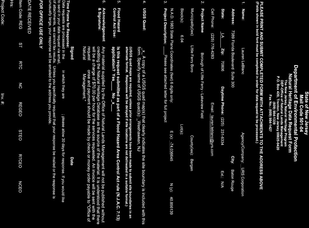
1 September 16, 2014 State of New Jersey Department of Environmental Protection Natural Heritage Data Request Form The New Jersey Natural Heritage Program DEP-Office of Natural Lands Management Mail Code P.O. Box E. State Street Station Plaza #5, 4 th Floor Trenton, New Jersey (609) Fax.: (609) Hi, URS is working with the New Jersey EDA on conducting site specific environmental reviews for the CDBG-Disaster Recovery, Neighborhood and Community Revitalization Program. Attached you will find a request form for a site currently under review, located at Lakeview Field, Little Ferry Boro, NJ. The proposed project will involve the reconstruction and improvement of a public facility, Lakeview Field, which will include improvements to the existing lighting, fencing, playing surface, and dugouts throughout the 5 fields. The 14.9 acre, Lakeview Field, is composed of 5 baseball/softball fields, of which two joining fields are inset within a football field, a stocked lake, gazebo, playground, and small walking trail. The project will include grading of the existing fields as needed, excavation of 6-12 inches of soil and installing synthetic turf at all of the fields. The synthetic turf installation will include an underdrain system, a perimeter edge where the turf and natural grass abut, base stone laid without damaging the soil bed, geotextile liner or drains, a layer of finishing stone, the synthetic turf, and a resilient layered infill. In preparation for the synthetic turf installation, all topsoil, organic, and noncompactable materials need to be removed, the soil bed must have a minimum slope of 0.5%, the soil bed must be compacted, the soil bed must be prepared to tolerances of not more than 1/2 from design grade to allow for even drainage, and lastly, a geotextile fabric is required to cover the soil bed. Additionally, the project will replace all field lights with highly energy efficient green lighting and install a lighting control system that will allow the city to remotely operate the lumens so that only the proper amount of lighting is emitted, thereby reducing electrical usage and costs. The project will also replace damaged or older fencing throughout the park, and replace the dugouts throughout the park. The dugouts will consist of eight (8) 6 X17 all steel single slope shelters placed on a 4 minimum thickness reinforced concrete slab. 24 gauge exposed fastener metal roofing and prime painted tube steel will be used to complete each of the dugouts. Additionally: URS Corporation 7389 Florida Blvd., Suite 300 Baton Rouge, LA Tel: Fax:

2 New synthetic turf is being installed 6-12 inches of soil is being excavated at each of the fields to install, Fences are being repaired/replaced, Lighting is being replaced, and Dugouts are being replaced. In order to conclude our environmental review, consultation with your program is required. Therefore, I am requesting a list of plant species that you feel will be affected by the project and some detail on why you believe the species will be affected. Results can be provided in any format you find best. If is acceptable, please the results to my address included below. Thank you so much in aiding our review. I look forward to hearing from you, Lauren LeBlanc Environmental Scientist URS Corporation 7389 Florida Blvd. Suite 300 Baton Rouge, LA Tel: (225) Direct: (225) lauren.leblanc@urs.com
3

4 NCR39505 Address: Lakeview Field Municipality: Little Ferry Boro USGS Quads: Weehawken, NJ Morris Co. Bergen Co. Essex Co. Hudson Co.!( NCR39505!( Site Location Proposed Action Site USGS Quad Boundary ,800 Feet

5 CHRIS CHRISTIE Governor KIM GUADAGNO Lt. Governor DEPARTMENT OF ENVIRONMENTAL PROTECTION State Forestry Services Mail Code ONLM -Natural Heritage Program P.O. Box 420 Trenton, NJ Tel. # Fax. # September 24, 2014 BOB MARTIN Commissioner Lauren LeBlanc URS Corporation 7389 Florida Boulevard, Suite 300 Baton Rouge, LA Re: Borough of Little Ferry-Lakeview Field Dear Ms. LeBlanc: Thank you for your data request regarding rare species information for the above referenced project site in Little Ferry Borough, Bergen County. Searches of the Natural Heritage Database and the Landscape Project (Version 3.1) are based on a representation of the boundaries of your project site in our Geographic Information System (GIS). We make every effort to accurately transfer your project bounds from the topographic map(s) submitted with the Request for Data into our Geographic Information System. We do not typically verify that your project bounds are accurate, or check them against other sources. We have checked the Landscape Project habitat mapping and the Biotics Database for occurrences of any rare wildlife species or wildlife habitat on the referenced site. The Natural Heritage Database was searched for occurrences of rare plant species or ecological communities that may be on the project site. Please refer to Table 1 (attached) to determine if any rare plant species, ecological communities, or rare wildlife species or wildlife habitat are documented on site. A detailed report is provided for each category coded as Yes in Table 1. We have also checked the Landscape Project habitat mapping and Biotics Database for occurrences of rare wildlife species or wildlife habitat in the immediate vicinity (within ¼ mile) of the referenced site. Additionally, the Natural Heritage Database was checked for occurrences of rare plant species or ecological communities within ¼ mile of the site. Please refer to Table 2 (attached) to determine if any rare plant species, ecological communities, or rare wildlife species or wildlife habitat are documented within the immediate vicinity of the site. Detailed reports are provided for all categories coded as Yes in Table 2. These reports may include species that have also been documented on the project site. The Natural Heritage Program reviews its data periodically to identify priority sites for natural diversity in the State. Included as priority sites are some of the State s best habitats for rare and endangered species and ecological communities. Please refer to Tables 1 and 2 (attached) to determine if any priority sites are located on or in the vicinity of the site. A list of rare plant species and ecological communities that have been documented from the project site, referenced above, can be downloaded from If suitable habitat is present at the project site, the species in that list have potential to be present. Status and rank codes used in the tables and lists are defined in EXPLANATION OF CODES USED IN NATURAL HERITAGE REPORTS, which can be downloaded from If you have questions concerning the wildlife records or wildlife species mentioned in this response, we recommend that you visit the interactive NJ-GeoWeb website at the following URL, or contact the Division of Fish and Wildlife, Endangered and ngame Species Program at (609)
6 PLEASE SEE CAUTIONS AND RESTRICTIONS ON NHP DATA, which can be downloaded from Thank you for consulting the Natural Heritage Program. The attached invoice details the payment due for processing this data request. Feel free to contact us again regarding any future data requests. Sincerely, c: NHP File Robert J. Cartica Administrator
7 Table 1: On Site Data Request Search Results (7 Possible Reports) Rare Plants/Ecological Communities Possibly On Site: Rare Plants/Ecological Communities On Site/Immediate Vicinity: Natural Heritage Priority Sites On Site: Landscape 3.1 Species Based Patches On Site: Landscape 3.1 Vernal Pool Habitat On Site: Landscape 3.1 Stream/Mussel Habitat On Site: Other Animals Tracked by ENSP On Site: Yes Wednesday, September 24, 2014 Page 1 of 1
8 Rare Wildlife Species or Wildlife Habitat on the Project Site Based on Search of Landscape Project 3.1 Species Based Patches Class Common Name Scientific Name Feature Type Rank Federal Protection Status State Protection Status Grank Srank Aves Glossy Ibis Snowy Egret Yellow-crowned Night-heron Plegadis falcinellus Foraging 2 NA Special Concern G5 S3B,S4N Egretta thula Foraging 2 NA Special Concern G5 S3B,S4N Nyctanassa violacea Foraging 3 NA State Threatened G5 S2B,S2N Wednesday, September 24, 2014 Page 1 of 1
9 Table 2: Vicinity Data Request Search Results (6 possible reports) Rare Plants/Ecological Communities within the Vicinity: Natural Heritage Priority Sites within the Vicinity: Landscape 3.1 Species Based Patches within the Vicinity: Landscape 3.1 Vernal Pool Habitat within the Vicinity: Landscape 3.1 Stream/Mussel Habitat within the Vicnity: Other Animals Tracked by ENSP within the Vicnity: Yes Wednesday, September 24, 2014 Page 1 of 1
10 Rare Wildlife Species or Wildlife Habitat Within the Immediate Vicinity of the Project Site Based on Search of Landscape Project 3.1 Species Based Patches Class Common Name Scientific Name Feature Type Rank Federal Protection Status State Protection Status Grank Srank Aves Bald Eagle Glossy Ibis Little Blue Heron Snowy Egret Yellow-crowned Night-heron Haliaeetus leucocephalus Foraging 4 NA State Endangered G5 S1B,S2N Plegadis falcinellus Foraging 2 NA Special Concern G5 S3B,S4N Egretta caerulea Foraging 2 NA Special Concern G5 S3B,S3N Egretta thula Foraging 2 NA Special Concern G5 S3B,S4N Nyctanassa violacea Foraging 3 NA State Threatened G5 S2B,S2N Wednesday, September 24, 2014 Page 1 of 1
18. Endangered Species
 Northern Branch Corridor SDEIS March 207 8. Endangered Species 8.. Chapter Overview 8... Introduction This chapter discusses the changes to the potential for project improvements to adversely affect threatened
Christina Kisiel NJ Division of Fish and Wildlife Endangered and Nongame Species Program
 Results of the 28 wading bird aerial survey in the coastal marshes of New Jersey & 29 Pilot Survey for Inland Heron Colonies in Northeast New Jersey Christina Kisiel NJ Division of Fish and Wildlife Endangered
Tiered Species Habitats (Terrestrial and Aquatic)
") Tiered Species Habitats (Terrestrial and Aquatic) Dataset Description Free-Bridge Area Map The Department of Game and Inland Fisheries (DGIF s) Tiered Species Habitat data shows the number of Tier 1, 2
Tiered Species Habitats (Terrestrial and Aquatic) Dataset Description Free-Bridge Area Map The Department of Game and Inland Fisheries (DGIF s) Tiered Species Habitat data shows the number of Tier 1, 2
New Jersey Audubon Society s. Garden State Audubon Council A Non-Profit Organization
 New Jersey Audubon Society s Important Bird and Birding Areas Program: Mapping Priority Areas for Conservation in the Delaware Estuary Cristina Frank, Program Coordinator Beth Ciuzio, Stewardship Project
Town of Skowhegan Application For Development Review
 Town of Skowhegan Application For Development Review Return to: Skowhegan Planning Office 225 Water St., Skowhegan, ME 04976 (207) 474-6904 skowcodesec@skowhegan.org To be filled in by Staff: Project Name:
WISCONSIN BIRD CONSERVATION INITIATIVE IMPORTANT BIRD AREAS PROGRAM
 WISCONSIN BIRD CONSERVATION INITIATIVE IMPORTANT BIRD AREAS PROGRAM NOMINATION FORM The Wisconsin Bird Conservation Initiative (WBCI) is conducting an inventory of areas that may qualify as Important Bird
New Jersey Dept. of Environmental Protection Shore Protection Program
 New Jersey Dept. of Environmental Protection William Dixon, Acting Manager 1510 Hooper Avenue, Suite 140 Toms River, New Jersey 08753 1-732-255-0767 New Jersey s State of New Jersey Chris Christie, Governor
Application Submittal Checklist for a BASIC USE PERMIT (BUP) Planning & Development Department Planning Division
 Planning & Development Department Planning Division") Application Submittal Checklist for a BASIC USE PERMIT (BUP) APPLICABILITY. This checklist should be used when submitting an application for a Basic Use Permit. When is a Basic Use Permit required? Section
Application Submittal Checklist for a BASIC USE PERMIT (BUP) APPLICABILITY. This checklist should be used when submitting an application for a Basic Use Permit. When is a Basic Use Permit required? Section
Preliminary Environmental Site Assessment Report
 Science Working For You Preliminary Environmental Site Assessment Report Wetland and Wildlife Survey Volusia County Parcel 06-19-32-00-00-0030 Prepared for: Orange Blossom Trail Orlando LLC 8650-12 Old
Species Conclusions Table
 Species Conclusions Table Project Manager: Theresita Crockett-Augustine Date: May 9, 2016 Project Name: Huntington Run Levee Project Number: NAO-2014-00272 Consultation Code: 05E2VA00-2016-SLI-1964 Event
CONSTRUCTION CERTIFICATION PACKAGE
 Purpose: The intent of this Construction Certification Package is to ensure that acceptable documentation is maintained during the construction of stormwater management practices (SMPs). For general information
Expansion Work Has Begun The perimeter dike for Cell 7 is now visible
 Summer/Fall 2017 In This Issue Poplar Island Expansion Wetland Cell 5AB Development Wildlife Update Birding tours on Poplar Island Expansion Work Has Begun The perimeter dike for Cell 7 is now visible
Survey Requirements. Design Guidelines and Standards. June Office of the University Architect
 Design Guidelines and Standards Survey Requirements June 2004 Office of the University Architect Construction Management P.O. Box 210181 Cincinnati, Ohio 45221-0181 Table of Contents Survey Requirements
Erie County Van Trip. Pipe Creek Wildlife Area
 Erie County Van Trip ***See red markings on maps indicating the best birding options at each location. Please note that you are not limited to these areas, they are just the areas we feel will be most
Mud Slough Wetland Reserve BCS number: 47-19
 Mud Slough Wetland Reserve BCS number: 47-19 ***NOTE: We were unable to determine all necessary information for this site description. If you would like to contribute the needed information to this description,
SUBMITTAL REQUIREMENTS FOR USE PROCESS III OR PROCESS IV
 COMMUNITY DEVELOPMENT DEPARTMENT 33325 8 th Avenue South Federal Way WA 98003 253-835-2607; Fax 253-835-2609 www.cityoffederalway.com SUBMITTAL REQUIREMENTS FOR USE PROCESS III OR PROCESS IV USE PROCESS
APPENDIX G. Biological Resources Reports
 APPENDIX G Biological Resources Reports November 9, 2009 David Geiser Merlone Geier Management, LLC 3580 Carmel Mountain Rd., Suite 260 San Diego, California 92130 RE: Neighborhood at Deer Creek, Petaluma,
Conceptual, Preliminary and Final Site Plan Review in Holladay City
 Conceptual, Preliminary and Final Site Plan Review in Holladay City The City of Holladay incorporated in December, 1999 and adopted its own zoning ordinance in May, 2000. All land use decisions are made
State of New Jersey BOARD OF PUBLIC UTILITIES 44 SO. CLINTON STREET 7 TH FLOOR P.O. BOX 350 TRENTON, NEW JERSEY
 State of New Jersey BOARD OF PUBLIC UTILITIES 44 SO. CLINTON STREET 7 TH FLOOR P.O. BOX 350 TRENTON, NEW JERSEY 08625-0350 CHRIS CHRISTIE GOVERNOR KIM GUADAGNO Lt. Governor March 24, 2011 LEE A. SOLOMON
Smith River Mouth BCS number: 86-6
 Smith River Mouth BCS number: 86-6 ***NOTE: We were unable to determine all necessary information for this site description. If you would like to contribute the needed information to this description,
HEXAGONAL DOUBBLE TWISTED GABION & ROCK FALL MATRESSES
 Menufatchurar of HEXAGONAL DOUBBLE TWISTED GABION & ROCK FALL MATRESSES As per IS 16014 (2012): Mechanically woven, double -twisted, hexagonal Wire Mesh Gabions, Revet Mattresses and Rock fallnetting(
SUMMIT COUNTY PLANNING AND ENGINEERING DEPARTMENT
 SUMMIT COUNTY PLANNING AND ENGINEERING DEPARTMENT SINGLE-FAMILY SITE PLAN INFORMATION PACKET GENERAL INFORMATION This information packet explains how your application for a single-family site plan will
StormTrap Guide Specification. StormTrap 2 SingleTrap on Aggregate Foundation Groundwater BELOW Invert Revised 11/30/17
 StormTrap Guide Specification StormTrap 2 SingleTrap on Aggregate Foundation Groundwater BELOW Invert Revised 11/30/17 This product guide specification is written according to the Construction Specifications
City of Hamilton INFORMATION FOR CONDITIONAL USE PERMIT
 City of Hamilton INFORMATION FOR CONDITIONAL USE PERMIT There is a $200.00 non-refundable fee for each request. Requests must be completed and submitted to the Public Works Department, City of Hamilton,
Golden Eagle (Aquila chrysaetos) Management Indicator Species Assessment Ochoco National Forest
 Management Indicator Species Assessment Ochoco National Forest") Golden Eagle (Aquila chrysaetos) Management Indicator Species Assessment Ochoco National Forest I. Introduction The golden eagle was chosen as a terrestrial management indicator species (MIS) on the Ochoco
Golden Eagle (Aquila chrysaetos) Management Indicator Species Assessment Ochoco National Forest I. Introduction The golden eagle was chosen as a terrestrial management indicator species (MIS) on the Ochoco
Minnesota Department of Natural Resources
 Minnesota Department of Natural Resources Division of Ecological and Water Resources, Box 25 500 Lafayette Road St. Paul, Minnesota 55155-4025 Phone: (651) 259-5109 E-mail: lisa.joyal@state.mn.us November
Bald Eagle Annual Report February 1, 2016
 Bald Eagle Annual Report 2015 February 1, 2016 This page intentionally blank. PROJECT SUMMARY Project Title: Bald Eagle HCP Monitoring Subject Area: Habitat Conservation Plan (HCP) monitoring Date initiated:
 EXISTING TREE TO REMAIN (REFER TO LANDSCAPE PLAN) 500 TANCA STREET, SUITE #209 SAN JUAN, PUERTO RICO 00901 TEL 7877244144 FAX 7877244144 19'7" MAX SIDE POOL SETBACK 1000' MAX POOL SETBACK 1000'/ PROPOSED
Fernhill Wetlands BCS number: 47-13
 Fernhill Wetlands BCS number: 47-13 ***NOTE: We were unable to determine all necessary information for this site description. If you would like to contribute the needed information to this description,
PLANNING DEPARTMENT SUBMITTAL REQUIREMENTS FOR CONDITIONAL USE PERMITS CLASS 4 DEVELOPMENT REVIEW PROCESS. A. Written Material
 PLANNING DEPARTMENT 970.668.4200 0037 Peak One Dr. PO Box 5660 www.summitcountyco.gov Frisco, CO 80443 SUBMITTAL REQUIREMENTS FOR CONDITIONAL USE PERMITS CLASS 4 DEVELOPMENT REVIEW PROCESS Per the provisions
12 March Terra Nova Planning and Research 400 S. Farrell Drive, Suite B-205 Palm Springs, CA (760) (FAX)
 (FAX)") 12 March 2010 Terra Nova Planning and Research 400 S. Farrell Drive, Suite B-205 Palm Springs, CA 92262 (760) 320-9040 (FAX) 322-2760 ATTN: John Criste RE: Altamira (TT 18255) Update to April 2007 Report
12 March 2010 Terra Nova Planning and Research 400 S. Farrell Drive, Suite B-205 Palm Springs, CA 92262 (760) 320-9040 (FAX) 322-2760 ATTN: John Criste RE: Altamira (TT 18255) Update to April 2007 Report
Rezoning/OCP Amendment Application. Current OCP Designation. Proposed OCP Designation
 Development Permit Application Rezoning/OCP Amendment Application Zoning DP Area yes no Variances Requested Development Details Property Size (m² or ha) Current Zoning Current OCP Designation Proposed
New Jersey Dept. of Environmental Protection Shore Protection Program
 New Jersey Dept. of Environmental Protection Benjamin Keiser, Manager 1510 Hooper Avenue, Suite 140 Toms River, New Jersey 08753 1-732-255-0767 New Jersey s State of New Jersey Chris Christie, Governor
Information for File # RMM
 Information for File # 3-4-RMM Applicant:, L.P. Corps Contact: Ryan Malterud Address: 8 Fifth Street East, St. Paul, Minnesota 56 E-Mail: Ryan.M.Malterud@usace.army.mil Phone: (65) 9-586 Primary County:
Grey County Natural Heritage System Study
 Grey County Natural Heritage System Study Green in Grey Technical Advisory Committee Meeting #1 February 25, 2015 225 Labrador Drive, Unit 1, Waterloo, Ontario, N2K 4M8 Tel: (519) 725-2227 Web: www.nrsi.on.ca
Draft Biological Assessment Report Design Update Technical Memorandum I-75 (SR 93) at SR 884 (Colonial Blvd) Interchange Lee County, Florida
 at SR 884 (Colonial Blvd) Interchange Lee County, Florida") Draft Biological Assessment Report Design Update I-75 (SR 93) at SR 884 (Colonial Blvd) Interchange Lee County, Florida Financial Project ID No. 413065-1-32-01 Prepared for: Florida Department of Transportation
Draft Biological Assessment Report Design Update I-75 (SR 93) at SR 884 (Colonial Blvd) Interchange Lee County, Florida Financial Project ID No. 413065-1-32-01 Prepared for: Florida Department of Transportation
NWP of 9 Enclosure
 A l b a n y Linn County Tax Lots S03W8BD0050 S03W8BA003 S03W8BA00700 Albany, OR 973 G e o R e s o u r c e s, L L C 000 0 000 000 Feet Scale: :,000 FIGURE : LOCATION MAP Scale: " =,000' Source: Albany GIS
Natural Resource Inventory/Forest Stand Delineation(NRI/FSD) and Forest Conservation Plan Exemption
 and Forest Conservation Plan Exemption") MONTGOMERY COUNTY PLANNING DEPARTMENT THE MARYLAND-NATIONAL CAPITAL PARK AND PLANNING COMMISSION Natural Resource Inventory/Forest Stand Delineation(NRI/FSD) and Forest Conservation Plan Exemption Application
MONTGOMERY COUNTY PLANNING DEPARTMENT THE MARYLAND-NATIONAL CAPITAL PARK AND PLANNING COMMISSION Natural Resource Inventory/Forest Stand Delineation(NRI/FSD) and Forest Conservation Plan Exemption Application
TOWN of LAKESHORE SITE PLAN CHECKLIST
 TOWN of LAKESHORE SITE PLAN CHECKLIST Last Revised December 17, 2009 Project Name: Project Location: Date Submitted: Name Phone Number E-mail Address Owner: Contractor/ Engineer: ( ) ( ) Applicant: ( )
New Jersey PRESERVING OUR WATERFOWLING TRADITION THROUGH HABITAT CONSERVATION!
 New Jersey PRESERVING OUR WATERFOWLING TRADITION THROUGH HABITAT CONSERVATION! he Delaware Bay and the New York Bight watersheds provide a multitude of critical wetland and upland habitats for fish and
APPENDIX A Vernal Field Office Best Management Practices for Raptors and Associated Habitats
 APPENDIX A Vernal Field Office Best Management Practices for Raptors and Associated Habitats A-1 A-2 APPENDIX A VERNAL FIELD OFFICE BEST MANAGEMENT PRACTICES FOR RAPTORS AND ASSOCIATED HABITATS September
Mystic Lake Hydroelectric Project FERC Project Number Year Bald Eagle Monitoring Summary Report Public
 Mystic Hydroelectric Project FERC Project Number 2301 3-Year Bald Eagle Monitoring Summary Report 2010-2013 Public 2013 by PPL Montana, LLC. ALL RIGHTS RESERVED Submitted to: Federal Energy Regulatory
Conservation Partners Legacy Grant Application
 CPL Applications (Total to date: 129) Spreadsheet Conservation Partners Legacy Grant Application CPL1000055 Name and Contact Project CPL1000055 Identifier: Roberts Bird Sanctuary Habitat Project Name:
2011 Wood River Wetland Yellow Rail (Coturnicops neveboracensis noveboracensis) Survey Report
 Survey Report") 2011 Wood River Wetland Yellow Rail (Coturnicops neveboracensis noveboracensis) Survey Report Project Description The Bureau of Land Management s Wood River Wetland is located in T34S-R 7 1/2E; the wetland
2011 Wood River Wetland Yellow Rail (Coturnicops neveboracensis noveboracensis) Survey Report Project Description The Bureau of Land Management s Wood River Wetland is located in T34S-R 7 1/2E; the wetland
The Quail Valley study area is located in the hills surrounding Railroad Canyon Reservoir, approximately 4 miles east of Lake Elsinore.
 County of Riverside - PSEC Project General Habitat Assessment Appendix A Quail Valley Quail Valley The Quail Valley study area is located in the hills surrounding Railroad Canyon Reservoir, approximately
Update on American Oystercatcher Reseach and Conservation in New Jersey
 Update on American Oystercatcher Reseach and Conservation in New Jersey - 2007 Todd Pover, New Jersey Division of Fish and Wildlife - Endangered and Nongame Species Program Tom Virzi, PhD Candidate Department
50.24 Type, Size and Location Plans for Culverts, Bridges and Culvert Bridges
 50.24 Culverts, Bridges and Culvert Bridges Type, Size and Location (T, S & L) Plans shall be required for all Bridges, Culvert Bridges and Culverts of eight-foot (8') clear span or greater as follows:
and and Natural Resources
 L and and Natural Resources GOAL: The health, diversity and integrity of New Jersey s natural resources will be sustained. Natural and scenic landscapes will be preserved and every person will have the
2014 Bentley Systems, Incorporated. Industry Futures Dean Bowman, PE Bentley Fellow Bentley Systems
 2014 Bentley Systems, Incorporated Industry Futures Dean Bowman, PE Bentley Fellow Bentley Systems Capital Project Lifecycle Built Environment Inspection Design Operations & Maintenance Drawings Redline
Sauvie Island Wildlife Area BCS number: 47-28
 Sauvie Island Wildlife Area BCS number: 47-28 Site description author(s) Mark Nebeker, Oregon Department of Fish and Wildlife, Sauvie Island Wildlife Area Manager Primary contact for this site Mark Nebeker,
HAMILTON TOWNSHIP Department of Planning and Zoning Application for a Commercial / Industrial Site Plan Review
 HAMILTON TOWNSHIP Department of Planning and Zoning Application for a Commercial / Industrial Site Plan Review Date: Application is hereby made for a Site Plan Review for a commercial or industrial use.
MINOR SUBDIVISION. [ ] [ ] [ ] [ ] B. Dimensions, bearings and curve data for all property lines and easements.
![MINOR SUBDIVISION. [ ] [ ] [ ] [ ] B. Dimensions, bearings and curve data for all property lines and easements.](/thumbs/90/102241643.jpg "MINOR SUBDIVISION. [ ] [ ] [ ] [ ] B. Dimensions, bearings and curve data for all property lines and easements.") MINOR SUBDIVISION 190-69. Minor subdivisions. In addition to the requirements indicated in 190-67 (SEE BELOW), the information below shall be shown on the plans for all minor subdivision applications.
MINOR SUBDIVISION 190-69. Minor subdivisions. In addition to the requirements indicated in 190-67 (SEE BELOW), the information below shall be shown on the plans for all minor subdivision applications.
Geographic [x Response Plan Map: GA-12 [r. Map Continued on GA-8 XXX. GA12-01 Green Island Sound. OSSABAW ISLAND WMA Raccoon Key XXX
 Charles Ogeechee River tal Waterway 31 52'30"N Little Ogeechee River Harveys Island 81 7'30"W Charles Rush Charles 950 Ogeechee River Geographic Response Plan Map: GA-12 Map Continued on GA-8 Green Island
PLANNING AND DEVELOPMENT
 OVERVIEW Effective January 1, 1992 all applications for multi-family residential and all non-residential building permits require site plan approval before permit issuance. All new developments and existing
Oregon Dunes National Recreation Area BCS Number: 47-5
 Oregon Dunes National Recreation Area BCS Number: 47-5 ***NOTE: We were unable to determine all necessary information for this site description. If you would like to contribute the needed information to
Step-by-Step Instructions for Documenting Compliance on the Bald Eagle Form For WSDOT s On-Call Consultants
 Introduction Step-by-Step Instructions for Documenting Compliance on the Bald Eagle Form For WSDOT s On-Call Consultants WSDOT Environmental Services Office Updated June 2011 This form is intended to document
Tualatin River NWR and Wapato Lake BCS number: 47-37
 Tualatin River NWR and Wapato Lake BCS number: 47-37 ***NOTE: We were unable to determine all necessary information for this site description. If you would like to contribute the needed information to
Last Name: First Name: M.I:
 ARCHITECTURE DESIGN REVIEW BOARD APPLICATION OFFICE USE ONLY APPLICATION # Permit # Fee Collected $ 1. Filing Status Initial Submission Amendment Withdrawal 2. Cost of Construction (Industry Standards)
Key Findings of the 2017 South Florida Wading Bird Report
 The 2017 wading bird nesting season produced some of the highest nest counts in a decade, with a total of 46,248 nests which represents a moderate improvement from the 10-year annual average of 39,065
WALCOOM. Walcoom Corporation POST ANCHOR.
 WALCOOM Walcoom Corporation Walcoom is a corporate that specialized in producing and selling various wire mesh and relative accessories. The production base of Walcoom Corp. is located in Anping county,
MINOR SITE PLAN APPLICATION COVER SHEET
 MINOR SITE PLAN APPLICATION COVER SHEET TOWN OF CLAYTON Planning Department 111 E. Second St., P.O. Box 879 Clayton, NC 27528 Phone: 919-553-5002 Fax: 919-553-1720 Name of Project: Date: Applicant Name:
SITE PLAN AMENDMENT POLICY 04/20/2016
 COUNTY OF ALBEMARLE Department of Community Development 401 McIntire Road, North Wing Charlottesville, Virginia 22902-4596 Phone (434) 296-5832 Fax (434) 972-4126 SITE PLAN AMENDMENT POLICY 04/20/2016
NWP of 10 Enclosure
 #6301 4/16/2018 Pacific Habitat Services, Inc. 9450 SW Commerce Circle, Suite 180 Wilsonville, OR 97070 Project Site General Location and Topography Reed Pit Expansion - Marion County, Oregon United States
there are no known Critical Environmental Area(s) on the site which will be impaired as the result of the proposed Actions; and
 on the site which will be impaired as the result of the proposed Actions; and") TOWN OF FARMINGTON PLANNING BOARD PB 0501-18 & 0502-18 SEQR Resolution Determination of Non-Significance Preliminary Subdivision Plat & Preliminary Site Plan, James Brenchley, 5106 Rushmore Road Whereas,
TOWN OF FARMINGTON PLANNING BOARD PB 0501-18 & 0502-18 SEQR Resolution Determination of Non-Significance Preliminary Subdivision Plat & Preliminary Site Plan, James Brenchley, 5106 Rushmore Road Whereas,
Section 1. Introduction
 Overview of Manual Acknowledgements i x Section 1. Introduction 1.0 Overview of Section 1 1-1 1.1 The GESC and DESC Permits 1-2 1.2 Reasons for the GESC and DESC Permits 1-2 1.3 Legislative Mandate 1-3
STATE OF NEW JERSEY BOARD OF PUBLIC UTILITIES
 STATE OF NEW JERSEY BOARD OF PUBLIC UTILITIES : IN THE MATTER OF THE PETITION OF : PUBLIC SERVICE ELECTRIC AND GAS : COMPANY FOR A DETERMINATION : PURSUANT TO THE PROVISIONS OF : N.J.S.A. 0:D-1 : BPU DOCKET
Tahkenitch Creek Estuary BCS number: 47-35
 Tahkenitch Creek Estuary BCS number: 47-35 ***NOTE: We were unable to determine all necessary information for this site description. If you would like to contribute the needed information to this description,
United States Department of the Interior
 United States Department of the Interior FISH AND WILDLIFE SERVICE New England Field Office 70 Commercial Street, Suite 300 Concord, Nil 03301-5087 http://www.fws. gov/newengland Environmental Division
Re: Environmental Review for Proposed Palmer Solar Project in El Paso County
 Southeast Region, Area 14 4255 Sinton Road Colorado Springs, CO 80907 P 719.227.5200 F 719.227.5223 May 21, 2018 juwi Inc. 1710 29 th Street, Suite 1068 Boulder, CO 80301 Re: Environmental Review for Proposed
TWIN ISLES COUNTRY CLUB AUDUBON COOPERATIVE SANCTUARY PROGRAM
 TWIN ISLES COUNTRY CLUB AUDUBON COOPERATIVE SANCTUARY PROGRAM What is the Audubon Cooperative Sanctuary Program? The Audubon Cooperative Sanctuary Program helps golf courses to enhance wildlife habitats
Bolinas Lagoon Heron and Egret Nesting Summary 2015
 Bolinas Lagoon Heron and Egret Nesting Summary 2015 With Results from Heronries at Picher Canyon, Kent Island, and the Bolinas Mainland Sarah A. Millus Cypress Grove Research Center Audubon Canyon Ranch
Subdivision Application Checklist
 City of Portsmouth, New Hampshire Subdivision Application Checklist This subdivision application checklist is a tool designed to assist the applicant in the planning process and for preparing the application
Eagle Observation Surveys Arkwright Summit Wind Project Chautauqua County, New York
 Eagle Observation Surveys Arkwright Summit Wind Project Chautauqua County, New York Final Report May August 2013 Prepared for: EDP Renewables 52 James Street 4 th Floor Albany, New York 12207 Prepared
Chapter 15. Land Descriptions and Drawings
 Chapter 15 Land Descriptions and Drawings Objectives This chapter will explore: Legal descriptions Common types of land drawings including a vicinity map, site, demolition, topography, grading, landscaping,
B.2 MAJOR SUBDIVISION PRELIMINARY PLAN CHECKLIST
 B.2 MAJOR SUBDIVISION PRELIMINARY PLAN CHECKLIST YES* GENERAL SUBMISSION ITEMS Does the submission include: 1. Thirteen (13) copies of completed Application Form? 2. Thirteen (13) copies of the Preliminary
Housing Authority of Utah County
 Legend Springville Site Vicinity Map (not to scale) Planning Department 110 South Main Street Phone (801) 491-7861 Fax (801) 489-2716 Community Development Director - J Fred Aegerter Public Works Department
SUBMITTAL REQUIREMENTS FOR COMMERCIAL SIGNAGE PROJECTS
 SUBMITTAL REQUIREMENTS FOR COMMERCIAL SIGNAGE PROJECTS When submitting your application for Commercial projects please include the following: 1. Completed Building Permit Application with page 2 stamped
ALISO VIEJO RANCH COMMUNITY FACILITIES PROJECT PHOTOMETRIC STUDY
 ALISO VIEJO RANCH COMMUNITY FACILITIES PROJECT PHOTOMETRIC STUDY Client: Environmental & Regulatory Specialists 2223 62 nd Street Newport Beach, California 9263 Prepared by Hongjoo Kim Landscape Architects,
Jackson Bottom Wetlands Preserve BCS Number: 47-14
 Jackson Bottom Wetlands Preserve BCS Number: 47-14 Site description author(s) Greg Gillson, Jackson Bottom Wetlands Preserve Primary contact for this site Ed Becker, Natural Resources Manager, Jackson
PLANNED SIGN PROGRAM CHECKLIST
 Planning and Building Agency Planning Division 20 Civic Center Plaza P.O. Box 1988 (M-20) Santa Ana, CA 92702 (714) 647-5804 PLANNED SIGN PROGRAM CHECKLIST Applicant, please return this checklist with
StormTrap Guide Specification. StormTrap SingleTrap on Pad Foundation Groundwater BELOW Invert Revised 11/21/18
 StormTrap Guide Specification StormTrap SingleTrap on Pad Foundation Groundwater BELOW Invert Revised 11/21/18 This product guide specification is written according to the Construction Specifications Institute
M E M O R A N D U M. Dianne Rosensweig, Scheda Ecological Associates, Inc. Environmental Assessment and Jurisdictional Determination
 M E M O R A N D U M TO: FROM: RE: Stephen Suau, P.E. Dianne Rosensweig, Scheda Ecological Associates, Inc. Environmental Assessment and Jurisdictional Determination Palmer Ranch Proposed Infill Project
# Insite RE Inc./ Verizon Wireless Special Use Permit Project Review for Planning and Zoning Commission
 #2015-52 Insite RE Inc./ Verizon Wireless Special Use Permit Project Review for Planning and Zoning Commission Meeting Date: October 21, 2015 Request: Location: A Special Use Permit for a wireless communication
DETAIL CROFT FARM OUTBUILDING RESTORATION TOWNSHIP OF CHERRY HILL, NEW JERSEY
 2x DIMENSIONAL LUMBER SISTER/SCAB REINFORCEMENT MEMBER 060523 3/8" A304 BOLT @ 8" O.C., STAGGERED EXISTING FRAMING MEMBER SECTION PROVIDE MIN EDGE DISTANCES AS SHOWN, TYP. ELEVATION REFER TO IFICATION
Bolinas Lagoon Heron and Egret Nesting Summary 2014
 Bolinas Lagoon Heron and Egret Nesting Summary 2014 With Results from Heronries at Picher Canyon, Kent Island, and the Bolinas Mainland Sarah A. Millus Cypress Grove Research Center Audubon Canyon Ranch
VARIANCE APPLICATION (NO SITE PLAN OR SUBDIVISION)
") VARIANCE APPLICATION (NO SITE PLAN OR SUBDIVISION) 190-66. General procedure for completeness review. A. In order to be determined complete for review by the Board, all of the required information must
VARIANCE APPLICATION (NO SITE PLAN OR SUBDIVISION) 190-66. General procedure for completeness review. A. In order to be determined complete for review by the Board, all of the required information must
East African Roofing Systems Ltd.
 East African Roofing Systems Ltd. Iron Sheet Super Tiger sheets are made from pre-painted galvanized iron sheets and combines increased longevity with low maintenance costs. Super Tigersheets are suitable
Restoration of Emergent Wetlands on Steve N. Wilson Raft Creek Bottoms WMA in the Mississippi Alluvial Plain Ecoregion
 Restoration of Emergent Wetlands on Steve N. Wilson Raft Creek Bottoms WMA in the Mississippi Alluvial Plain Ecoregion Project Summary: The Arkansas Wildlife Action Plan has identified six marsh bird species
STATE UNIVERSITY CONSTRUCTION FUND
 DIRECTIVE 1C-12 Issue date: August 2012 1. General SURVEY, MAPPING AND UTILITY LOCATING This Directive has been developed as a general guide for the survey and mapping effort required for Fund projects.
BV-24A DMMA Florida Scrub-Jay Survey Brevard County
 REPORT BV-24A DMMA Florida Scrub-Jay Survey Brevard County Submitted to: David L. Stites, Ph.D. Director of Environmental Services Taylor Engineering, Inc. 10199 Southside Blvd Suite 310 Jacksonville,
1/18/2008. Wetlands Reservoirs of Biodiversity Billy McCord, SCDNR. Estuaries. Freshwater Riverine. Tidal Riverine Fresh & Brackish
 Wetlands Reservoirs of Biodiversity Billy McCord, SCDNR Estuaries Freshwater Riverine Tidal Riverine Fresh & Brackish 1 Freshwater Riverine, Oxbows & Swamp Forest Cypress Tupelo Swamp Forest Bottomland
What Plans Do I Need for a Building Permit?
 What Plans Do I Need for a Building Permit? 6 CITY OF PORTLAND, OREGON - BUREAU OF DEVELOPMENT SERVICES 1900 SW 4th Avenue, Por tland, Oregon 97201 503-823-7300 www.portlandoregon.gov/bds This brochure
Relicensing Study 3.5.1
 Relicensing Study 3.5.1 BASELINE INVENTORY OF WETLAND, RIPARIAN AND LITTORAL HABITAT IN THE TURNERS FALLS IMPOUNDMENT, AND ASSESSMENT OF OPERATIONAL IMPACTS ON SPECIAL-STATUS SPECIES Updated Study Report
MASSABESIC AUDUBON CENTER SCHOOL PROGRAMS Let your students Find Science in Nature! Programs correlate with the N.H. Science Literacy Frameworks
 MASSABESIC AUDUBON CENTER SCHOOL PROGRAMS Let your students Find Science in Nature! Programs correlate with the N.H. Science Literacy Frameworks Let New Hampshire Audubon help your classroom discover a
Mexican Spotted Owl Monitoring and Inventory from in the Lincoln National Forest, New Mexico
 Mexican Spotted Owl Monitoring and Inventory from 2001-2005 in the Lincoln National Forest, New Mexico Submitted to: Rene Guaderrama Lincoln National Forest Sacramento Ranger District P. O. Box 288 Cloudcroft,
ANNEX Following the discussions at the National Environmental Protection Agency in Bucharest on to clarify some aspects regarding the
 ANNEX Following the discussions at the National Environmental Protection Agency in Bucharest on 08.25.2014 to clarify some aspects regarding the Appropriate Assessment Study of the above-mentioned project
Minor Site Plan Application and Checklist Land Disturbing Activities
 Minor Site Plan Application and Checklist Land Disturbing Activities INSTRUCTIONS: Please provide the requested information below. The Development Services Department reviews each site plan submittal based
RE: 13UN034 City of Iqaluit New Landfill and Waste Transfer Station NIRB Screening
 Environmental Protection Operations Directorate Prairie & Northern Region 5019 52 nd Street, 4 th Floor File: 6200 000 001/009 P.O. Box 2310 NIRB File: 13UN034 Yellowknife, NT X1A 2P7 January 10, 2019
KANSAS DEPARTMENT OF TRANSPORTATION SPECIAL PROVISION TO THE STANDARD SPECIFICATIONS, 1990 EDITION
 Sheet 1 of 5 KANSAS DEPARTMENT OF TRANSPORTATION SPECIAL PROVISION TO THE STANDARD SPECIFICATIONS, 1990 EDITION NOTE: This special provision is generally written in the imperative mood. The subject, "the
Group Programs for Schools & Communities
 Group Programs for Schools & Communities School, Youth & Community Groups Trailside Nature & Science Center is the Environmental Education Center of the Union County Department of Parks and Recreation,