Mid-Clare Coast Special Protection Area. Conservation Objectives Supporting Document
|
|
|
- Junior Cummings
- 5 years ago
- Views:
Transcription
1 Mid-Clare Coast Special Protection Area (Site Code 4182) Conservation Objectives Supporting Document VERSION 1 National Parks & Wildlife Service July 2014
2 SUMMARY T A B L E O F C O N T E N T S PART ONE - INTRODUCTION Introduction to the designation of Special Protection Areas Introduction to Mid-Clare Coast Special Protection Area Introduction to Conservation Objectives... 3 PART TWO SITE DESIGNATION INFORMATION Special Conservation Interests of Mid-Clare Coast Special Protection Area... 4 PART THREE CONSERVATION OBJECTIVES FOR MID-CLARE COAST SPA Conservation Objectives for the non-breeding Special Conservation Interests of Mid-Clare Coast SPA... 6 PART FOUR REVIEW OF THE CONSERVATION CONDITION OF WATERBIRD SPECIAL CONSERVATION INTERESTS Population data for waterbird SCI species of Mid-Clare Coast SPA Waterbird population trends for Mid-Clare Coast SPA Mid-Clare Coast SPA site conservation condition of waterbird SCI species PART FIVE SUPPORTING INFORMATION Introduction Waterbird species Ecological characteristics, requirements and specialities summary information The 2010/11 waterbird survey programme Introduction Waterbird data, analyses and presentation Summary Results Waterbird distribution Mid-Clare Coast - Activities and Events Introduction Assessment Methods Overview of activities at Mid-Clare Coast Disturbance Assessment Discussion REFERENCES APPENDIX APPENDIX APPENDIX APPENDIX APPENDIX APPENDIX APPENDIX APPENDIX APPENDIX APPENDIX
3 SUMMARY This document presents conservation objectives for the non-breeding Special Conservation Interests of Mid-Clare Coast Special Protection Area, designated under Directive 2009/147/EC on the conservation of wild birds (Birds Directive). Part One presents an introduction to the Special Protection Area (SPA) designation process and to the site designated as Mid-Clare Coast Special Protection Area, as well as introducing the concept of conservation objectives and their formulation. Part Two provides site designation information for Mid-Clare Coast SPA and Part Three presents the conservation objectives for this site. Part Four reviews the conservation condition of the site Special Conservation Interest (SCI) species based on an analysis of wintering (non-breeding) population trends. Importantly, this section states the current conservation condition of each of the SCI species and examines these site trends in light of all-ireland and international status and trends. Part Five provides supporting information that will assist the interpretation of the site-specific conservation objectives. This section includes a review of the ecological characteristics of the SCI species and examines waterbird distribution recorded during the 2010/11 Waterbird Survey Programme, drawing also on data from NPWS monitoring programmes (e.g. benthic surveys) and the Irish Wetland Bird Survey (I-WeBS). Part Five concludes with information on activities and events that occur in and around the site which may interact with waterbirds during the non-breeding season and includes an assessment of those activities that were recorded to cause disturbance to non-breeding waterbirds during the 2010/11 Waterbird Survey Programme.
4 PART ONE - INTRODUCTION 1.1 Introduction to the designation of Special Protection Areas The over-arching framework for the conservation of wild birds within Ireland and across Europe is provided by Directive 2009/147/EC on the conservation of wild birds (the codified version of Council Directive 79/409/EEC as amended) (Birds Directive). Together with the EU Habitats Directive (Council Directive 92/43/EEC), these legislative measures provide for wild bird protection via a network of protected sites across Europe known as Natura 2000 sites, of which the overriding conservation objective is the maintenance (or restoration) of favourable conservation status of habitats and species. Under Article 4 of Directive 2009/147/EC, Ireland, along with other Member States, is required to classify the most suitable territories in number and size as Special Protection Areas (SPAs) for the conservation of certain wild bird species, which are: species listed in Annex I of the directive regularly occurring migratory species Also under Article 4, Member States are required to pay particular attention to the protection of wetlands, especially those of international importance. The National Parks & Wildlife Service (NPWS), part of the Department of the Arts, Heritage and the Gaeltacht, is responsible for the selection and designation of SPAs in Ireland. NPWS has developed a set of criteria, incorporating information relating to the selection of wetland sites developed under the Ramsar Convention, which are used to identify and designate SPAs. Sites that meet any of the following criteria may be selected as SPAs: A site regularly supporting 20,000 waterbirds or 10,000 pairs of seabirds; A site regularly supporting 1% or more of the all-ireland population of an Annex I species; A site regularly supporting 1% or more of the biogeographical population of a migratory species; A site that is one of the n most suitable sites in Ireland for an Annex I species or a migratory species (where n is a variable which is related to the proportion of the total biogeographic population of a species held by Ireland). The biogeographic population estimates and the recommended 1% thresholds for wildfowl and waders are taken from Wetlands International (Wetlands International, 2002); thresholds reflecting the baseline data period used. The all-ireland populations for the majority of wintering waterbirds are taken from Crowe et al. (2008). Site specific information relevant to the selection and designation of a SPA is collated from a range of sources including the Irish Wetland Bird Survey (I-WeBS), The Wetland Bird Survey (WeBS) in Northern Ireland, species specific reports and a wide range of scientific publications, reports and other surveys. If, following collation of all the available scientific data, a site meets the relevant criteria for designation and is selected as an SPA, a list of species for which the site is nationally and internationally important is compiled. These species are known as Special Conservation Interests and may be one of the following: An Annex I species that occurs at the site in numbers that exceed the all-ireland 1% population threshold; A migratory species that occurs at the site in numbers that exceed the biogeographic 1% population threshold ( internationally important ); A migratory species that occurs at the site in numbers that exceed the all-ireland 1% threshold ( all-ireland importance ); 1
5 A species for which the site is considered to be one of the n most suitable sites in Ireland for the conservation of that species (where n is a variable that is related to the proportion of the total biogeographic population held by Ireland). The wetlands of northwest Europe are a vital resource for millions of northern and boreal nesting waterbird species that overwinter on these wetlands or visit them when migrating further south. To acknowledge the importance of Ireland's wetlands to wintering waterbirds the term Wetland & Waterbirds can be included as a Special Conservation Interest for a Special Protection Area that has been designated for wintering waterbirds, and is or contains a wetland site of significant importance to one or more of the species of Special Conservation Interest. 1.2 Introduction to Mid-Clare Coast Special Protection Area Mid-Clare Coast SPA extends along the Co. Clare coastline in a south-south-westerly direction from Spanish Point (3 km west of Milltown Malbay) to just west of Doonbeg Bay, a distance of some 14 km. It comprises the mainland shoreline, a series of rocky reefs, Mutton Island and Mattle Island, and the open marine water of Mal Bay between the islands and the mainland. Underlying the site are Carboniferous grits which are bedded at a low angle and which give rise to surf conditions in places along the coast. The headlands and islands experience some of the most severe conditions of exposure in Ireland. Also included within the site is Lough Donnell which is a classic lagoon with one of the most impressive barriers in the country. The mainland shoreline is mostly rocky or stony, though there are several sandy beaches and areas of intertidal flats. There are excellent examples of littoral reef communities. Shingle or stony banks are found at the base of cliffs and at the head of bays. Due to their exposure these support a sparse cover of vegetation. Sand dune systems are found near Spanish Point, about Lurga Point and further south. The stretch of coastline between Quilty and Lurga Point has extensive areas of mud and sand flats; further intertidal flats occur at Doughmore Bay and Doonbeg Bay. Mutton Island is a medium-sized, uninhabited island situated approximately 1 km from Lurga Point. It is a fairly low-lying island, rising to 28 m in the west where some cliffs occur. The south and eastern shores are low-lying and comprised of cobbles and boulders. Several small sandy coves exist. Much of the interior of the island is unmanaged dry grassland with a maritime character although wet grassland also occurs and, in places, heath vegetation has developed. A small freshwater pond occurs on the island. A group of littoral reefs occur to the north, notably Carrickaneelwar and Seal Rock. Mattle Island is a small island situated approximately 2 km south of Mutton Island. It is a lowlying island, rising to only 12 m in the central area. The island is highly exposed to the force of the Atlantic Ocean. The terrestrial component of the island is dominated by maritime grassland. Lough Donnell is a generally shallow lagoon of 12.5 ha in size (NPWS, 2014b). Coastal lagoons are priority habitats under the EU Habitats Directive and this lagoon forms part of the Carrowmore Point to Spanish Point and Islands Special Area of Conservation (Site Code 1021). Mid-Clare Coast SPA is of special conservation interest for the following non-breeding waterbird species: Barnacle Goose, Ringed Plover, Sanderling, Purple Sandpiper, Dunlin and Turnstone, plus one breeding species (Cormorant). The Site Synopsis and a map showing the SPA boundary are given in Appendix 1. 2
6 1.3 Introduction to Conservation Objectives The overriding objective of the Habitats Directive is to ensure that the habitats and species covered achieve favourable conservation status and that their long-term survival is secured across their entire natural range within the EU (EU Commission, 2012). In its broadest sense, favourable conservation status means that an ecological feature is being maintained in a satisfactory condition, and that this status is likely to continue into the future. Definitions as per the EU Habitats Directive are given in Box 1. Box 1 Favourable Conservation Status as defined by Articles 1 (e) and 1(i) of the Habitats Directive The conservation status of a natural habitat is the sum of the influences acting on it and its typical species that may affect its long-term natural distribution, structure and functions as well as the long-term survival of its typical species. The conservation status of a natural habitat will be taken as favourable when: its natural range and areas it covers within that range are stable or increasing; and the specific structure and functions which are necessary for its long-term maintenance exist and are likely to continue to exist for the foreseeable future; and the conservation status of its typical species is favourable. The conservation status of a species is the sum of the influences acting on the species that may affect the long-term distribution and abundance of its populations. The conservation status will be taken as favourable when: the population dynamics data on the species concerned indicate that it is maintaining itself on a long-term basis as a viable component of its natural habitats; and the natural range of the species is neither being reduced nor is likely to be reduced for the foreseeable future; and there is, and will probably continue to be, a sufficiently large habitat to maintain its populations Site-specific conservation objectives define the desired condition or range of conditions that a habitat or species should be in, in order for these selected features within the site to be judged as favourable. At site level, this state is termed favourable conservation condition. Site conservation objectives also contribute to the achievement of the wider goal of biodiversity conservation at other geographic scales, and to the achievement of favourable conservation status at national level and across the Natura 2000 network 1. Where relevant, conservation objectives are defined for attributes 2 relating to waterbird species populations, and for attributes related to the maintenance and protection of habitats that support them. These attributes are: Population trend; Population distribution; Habitat range and area (extent). Further guidance is given in Section 3.1 (Conservation Objectives for the Special Conservation Interests of Mid-Clare Coast Special Protection Area). 1 Note that the terms conservation condition and conservation status are used to distinguish between site and the national level objectives respectively. 2 Attribute can be defined as: a characteristic of a habitat, biotope, community or population of a species which most economically provides an indication of the condition of the interest feature to which it applies (JNCC, 1998). 3
7 PART TWO SITE DESIGNATION INFORMATION 2.1 Special Conservation Interests of Mid-Clare Coast Special Protection Area The Special Conservation Interest species 3 for Mid-Clare Coast SPA are listed below and summarised in Table 2.1. This table also shows the importance of Mid-Clare Coast SPA for these SCI species, relative to the importance of other sites within Ireland, within the Mid West region 4 and within County Clare. The Special Conservation Interests listed for Mid-Clare Coast SPA are as follows:- 1. During winter the site regularly supports 1% or more of the all-ireland population of Barnacle Goose (Branta leucopsis). The mean peak number of this Annex I species within the SPA during the baseline period ( ) was 250 individuals. 2. During the breeding season the site regularly supports 1% or more of the all-ireland population of Cormorant (Phalacrocorax carbo). The peak number of this species recorded in 1990 was 60 breeding pairs. 3. During winter the site regularly supports 1% or more of the all-ireland population of Ringed Plover (Charadrius hiaticula). The mean peak number of this species within the SPA during the baseline period (1995/ /00) was 316 individuals. 4. During winter the site regularly supports 1% or more of the all-ireland population of Sanderling (Calidris alba). The mean peak number of this species within the SPA during the baseline period (1995/ /00) was 272 individuals. 5. During winter the site regularly supports 1% or more of the biogeographic population of Purple Sandpiper (Calidris maritima). The mean peak number of this species within the SPA during the baseline period (1995/ /00) was 393 individuals. 6. During winter the site regularly supports 1% or more of the all-ireland population of Dunlin (Calidris alpina). The mean peak number of this species within the SPA during the baseline period (1995/ /00) was 2,708 individuals. 7. During winter the site regularly supports 1% or more of the all-ireland population of Turnstone (Arenaria interpres). The mean peak number of this species within the SPA during the baseline period (1995/ /00) was 571 individuals. 8. The wetland habitats contained within Mid-Clare Coast SPA are identified of conservation importance for non-breeding (wintering) and breeding migratory waterbirds. Therefore the wetland habitats are considered to be an additional Special Conservation Interest. 3 Special Conservation Interest species are listed in taxonomic order. 4 Region refers to regions as defined by Irish Regions Office. 4
8 Table 2.1 Site Designation Summary: species listed for Mid-Clare Coast Special Protection Area, plus site importance at national, regional and county scale Special Conservation Interests Annex I species Baseline Population a Barnacle Goose Branta leucopsis Cormorant Phalacrocorax carbo Ringed Plover Charadrius hiaticula Sanderling Calidris alba Purple Sandpiper Calidris maritima Dunlin Calidris alpina Turnstone Arenaria interpres Other conservation designations associated with the site b Population status at baseline National Importance Rank 1 Regional Importance Rank 2 County Importance Rank 3 Yes 250 All-Ireland Importance breeding pairs All-Ireland Importance All-Ireland Importance All-Ireland Importance International Importance ,708 All-Ireland Importance All-Ireland Importance SAC RAMSAR SITE IMPORTANT BIRD AREA (IBA) WILDFOWL SANCTUARY OTHER SAC ; 2250 Yes Mutton Island pnha a Baseline data are the 5-year mean peak counts for the period 1995/ /00 (I-WeBS) with the exception of Barnacle Goose and Cormorant. For Barnacle Goose the data represents the mean number from four surveys undertaken during the period For Cormorant, the data refers to the 1990 breeding season. b Note that other designations associated with Mid-Clare Coast may relate to different areas and/or some of these areas may extend outside the SPA boundary. 1 National importance rank the number given relates to the importance of the site for the non-breeding populations of the SCI species during the baseline period relative to other sites in Ireland. 2 Regional importance rank - the number given relates to the importance of the site for the non-breeding populations of the SCI species during the baseline period relative to other sites within the Mid West Region. 3 County importance rank - the number given relates to the importance of the site for the non-breeding populations of the SCI species during the baseline period relative to other sites within Co. Clare. OTHER 5
9 PART THREE CONSERVATION OBJECTIVES FOR MID-CLARE COAST SPA 3.1 Conservation Objectives for the non-breeding Special Conservation Interests of Mid-Clare Coast SPA The overarching Conservation Objective for Mid-Clare Coast Special Protection Area is to ensure that waterbird populations and their wetland habitats are maintained at, or restored to, favourable conservation condition. This includes, as an integral part, the need to avoid deterioration of habitats and significant disturbance; thereby ensuring the persistence of site integrity. The site should contribute to the maintenance and improvement where necessary, of the overall favourable status of the national resource of waterbird species, and continuation of their long-term survival across their natural range. Conservation Objectives for Mid-Clare Coast Special Protection Area, based on the principles of favourable conservation status, are described below and summarised in Table 3.1. Note that these objectives should be read and interpreted in the context of information and advice provided in additional sections of this report. Objective 1: To maintain the favourable conservation condition of the non-breeding waterbird Special Conservation Interest species listed for Mid-Clare Coast SPA. This objective is defined by the following attributes and targets:- To be favourable, the long term population trend for each waterbird Special Conservation Interest species should be stable or increasing. 5 Waterbird populations are deemed to be unfavourable when they have declined by 25% or more, as assessed by the most recent population trend analysis. 6 To be favourable, there should be no significant decrease in the range, timing or intensity of use of areas by the waterbird species of Special Conservation Interest, other than that occurring from natural patterns of variation. 7 Factors that can adversely affect the achievement of Objective 1 include: Habitat modification: activities that modify discrete areas or the overall habitat(s) within the SPA in terms of how one or more of the listed species use the site (e.g. as a feeding resource) could result in the displacement of these species from areas within the SPA and/or a reduction in their numbers (for further discussion on this topic please refer to Section 5.4). Disturbance: anthropogenic disturbance that occurs in or near the site and is either singular or cumulative in nature could result in the displacement of one or more of the listed waterbird species from areas within the SPA, and/or a reduction in their numbers (for further discussion on this topic please refer to Section 5.4). 5 Note that population refers to site population (numbers wintering at the site) rather than the species biogeographic population. 6 Population trend analysis is presented in Section 4. 7 Waterbird distribution from the 2010/2011 waterbird survey programme is examined in Section 5. 6
10 Ex-situ factors: several of the listed waterbird species may at times use habitats situated within the immediate hinterland of the SPA or in areas outside of the SPA but ecologically connected to it. The reliance on these habitats will vary from species to species and from site to site. Significant habitat change or increased levels of disturbance within these areas could result in the displacement of one or more of the listed waterbird species from areas within the SPA, and/or a reduction in their numbers (for further information on this topic please refer to Section 5.2). Objective 2: To maintain the favourable conservation condition of the wetland habitat at Mid- Clare Coast SPA as a resource for the regularly-occurring migratory waterbirds that utilise it. This objective is defined by the following attributes and targets:- To be favourable, the permanent area occupied by the wetland habitat should be stable and not significantly less than the area of 4,641 ha, other than that occurring from natural patterns of variation. The boundary of Mid-Clare Coast SPA was defined to include the primary wetland habitats of this site. Objective 2 seeks to maintain the permanent extent of these wetland habitats, which constitute an important resource for regularly-occurring migratory waterbirds. The wetland habitats can be categorised into four broad types: subtidal; intertidal; supratidal; and lagoon and associated habitats. Over time and through natural variation these subcomponents of the overall wetland complex may vary due to factors such as changing rates of sedimentation, erosion etc. Waterbird species may use more than one of the habitat types for different reasons (behaviours) throughout the tidal cycle. Subtidal areas refer to those areas contained within the SPA that lie below the mean low water mark and are predominantly covered by marine water. Tidal rivers, creeks and channels are included in this category. For Mid-Clare Coast SPA this broad category is estimated to be 4,014 ha. Subtidal areas are continuously available for benthic and surface feeding waterfowl (e.g. Wigeon) and piscivorous/other waterbirds, while various waterbirds roost in subtidal areas. The intertidal area is defined, in this context, as the area contained between the mean high water mark and the mean low water mark. For Mid-Clare Coast SPA this is estimated to be 454 ha. When exposed or partially exposed by the tide, intertidal habitats provide important foraging areas for many species of waterbirds, especially wading birds, as well as providing roosting/loafing 8 areas. When the intertidal area is inundated by the tide it becomes available for benthic and surface feeding ducks and piscivorous/other waterbirds. During this tidal state this area can be used by various waterbirds as a loafing/roosting resource. The supratidal category refers to areas that are not frequently inundated by the tide (i.e. occurring above the mean high watermark) but contain shoreline and coastal habitats and can be regarded as an integral part of the shoreline. For Mid-Clare Coast SPA this is estimated to be 58 ha. Supratidal areas are used by a range of waterbird species as a roosting resource as well as providing feeding opportunities for some species. The category known as lagoon and associated habitats relates to Lough Donnell and associated habitats. This broad habitat category is estimated to be 115 ha. The maintenance of the quality of wetland habitat lies outside the scope of Objective 2. However, for the species of Special Conservation Interest, the scope of Objective 1 covers 8 Loafing can be described as any behaviour not connected with breeding or feeding, and includes preening and resting. 7
11 the need to maintain, or improve where appropriate, the different properties of the wetland habitats contained within the SPA. 8
12 Table 3.1 Conservation Objectives for the waterbird Special Conservation Interests of Mid-Clare Coast SPA. Objective 1: To maintain the favourable conservation condition of the waterbird Special Conservation Interest species listed for Mid-Clare Coast SPA, which is defined by the following list of attributes and targets: Parameter Attribute Measure Target Notes Population Population trend Percentage change as per population trend assessment using waterbird count data collected through the Irish Wetland Bird Survey and other surveys. Range Distribution Range, timing or intensity of use of areas used by waterbirds, as determined by regular low tide and other waterbird surveys. The long term population trend should be stable or increasing There should be no significant decrease in the range, timing or intensity of use of areas by the waterbird species of Special Conservation Interest other than that occurring from natural patterns of variation. Objective 2: Waterbird population trends are presented in Part Four of this document. Waterbird distribution from the 2010/11 waterbird survey programme is reviewed in Part Five of this document. To maintain the favourable conservation condition of the wetland habitat at Mid-Clare Coast SPA as a resource for the regularly-occurring migratory waterbirds that utilise it. This is defined by the following attributes and targets: Parameter Attribute Measure Target Notes Area Wetland habitat Area (ha) The permanent area occupied by the wetland habitat should be stable and not significantly less than the area of 4,641 ha, other than that occurring from natural patterns of variation. The wetland habitat area was estimated as 4,641 ha using OSI data and relevant orthophotographs. 9
13 PART FOUR REVIEW OF THE CONSERVATION CONDITION OF WATERBIRD SPECIAL CONSERVATION INTERESTS 4.1 Population data for waterbird SCI species of Mid-Clare Coast SPA Non-breeding waterbirds are counted at Mid-Clare Coast each winter as part of the Irish Wetland Bird Survey (I-WeBS). The dataset spans the period 1994/95 to 2010/11 with the exception of 2000/01 and 2003/04. Monthly count coverage has been variable with between one and seven counts carried out during the core survey period; a time-span that covers the main wintering period when many species occur in their largest concentrations, but also the autumn and spring passage periods when total waterbird numbers may be enhanced by staging/stopover birds 9. During I-WeBS the site is subdivided into various count subsites. The total count area is approximately 3,800 ha (Crowe, 2005). Note that the SPA area and the I-WeBS count area are not coincident. In Ireland, Barnacle Geese occur mostly in remote and inaccessible areas so routine I-WeBS surveys cannot assess their numbers. This species is therefore surveyed by aerial census every five years; Mutton Island, part of Mid-Clare Coast SPA being included within the survey area. Further details on this census and other waterbird surveys are given in Appendix 2. Table 4.1 presents population 10 data for the non-breeding waterbird SCI species of Mid-Clare Coast SPA. For all species except Barnacle Goose, annual maxima were identified and used to calculate the five-year mean peak for each species. The baseline period was 1995/ /00 while the recent three-year average relates to the period 2006/ /11 (data for 2007/08 and 2008/09 unavailable). Recent site peak counts are also shown. Data for Barnacle Goose are from the five-yearly aerial census; the baseline data being the mean of four surveys undertaken between 1993 and 2003, while the recent mean peak is the average of four surveys undertaken between 1999 and When examining waterbird data, it is standard practice to use the mean of peak counts generated for each species because it reflects more accurately the importance of a site for a particular species by helping to account for inconsistencies in data gathering (i.e. differing coverage) or extraordinary fluctuations in numbers. However it is important to note that waterbird counts represent a snapshot of bird numbers during a count session, so in general and taking into account all potential sources of error, resulting data are regarded to be underestimates of population size (Underhill & Prŷs-Jones, 1994). Table 4.1 indicates where the numbers shown surpass the threshold for all-ireland or international importance. These thresholds are different for the baseline and recent time periods used; international thresholds are outlined in Wetlands International (2002) and Wetlands International (2012), while all-ireland thresholds are presented within Crowe et al. (2008) and Crowe & Holt (2013) for the baseline and recent site data respectively. 9 The terms stopover and staging are often used interchangeably. A stopover site can be defined as any place where a bird takes a break during migration. Staging areas can be defined as stopover sites that attract large numbers of individuals and play an important part in re-fuelling the birds before their onward migration (e.g. Warnock, 2010). 10 Note that population refers to site population (numbers wintering at the site) rather than a species biogeographic population. 10
14 Table 4.1 Population data for non-breeding waterbird Special Conservation Interest Species of Mid-Clare Coast SPA Site Special Conservation Interests (SCIs) Baseline peak mean 1 (1995/ /00) Recent peak mean 2 (2006/ /11) Recent Site peak 3 (2006/ /11) Recent Site Peak 4 (2010/11) Barnacle Goose Branta leucopsis 250 (n) 235 (n) 450 (n) - Ringed Plover Charadrius hiaticula 316 (n) (n) Sanderling Calidris alba 272 (n) 143 (n) 180 (n) 46 Purple Sandpiper Calidris maritima 393 (i) 61 (n) 100 (n) 169 (n) Dunlin Calidris alpina 2,708 (n) (n) Turnstone Arenaria interpres 571 (n) 145 (n) 203 (n) 482 (n) 1 baseline data is the 5-year mean peak for the period 1995/ /00 (I-WeBS) with the exception of Barnacle Goose where the mean number is from four surveys undertaken during the period recent site data is the three-year mean peak for the period 2006/ /11 (I-WeBS) with the exception of Barnacle Goose where the mean number is from four aerial surveys undertaken in 1999, 2003, 2008 and recent site peak is the peak number recorded during the period 2006/ /11 (I-WeBS) with the exception of Barnacle Goose which is the peak count from four surveys undertaken in 1999, 2003, 2008 and recent site peak is the peak high tide count from co-ordinated surveys undertaken during the 2010/11 Waterbird Survey Programme (NPWS). (i) denotes numbers of international importance; (n) denotes numbers of all-ireland importance. note that thresholds differ for the baseline and recent time periods used; international thresholds are outlined in Wetlands International (2002) and Wetlands International (2012), while all-ireland thresholds are presented within Crowe et al. (2008) and Crowe & Holt (2013) for the baseline and recent site data respectively. 4.2 Waterbird population trends for Mid-Clare Coast SPA The calculation and assessment of waterbird population trends at Irish coastal SPA sites follows the UK Wetland Bird Survey Alerts System which provides a standardised technique for monitoring changes in the numbers of non-breeding waterbirds over a range of spatial scales and time periods. A detailed methodology for this analysis is provided in Appendix 3. For Mid-Clare Coast however, a relatively low level of annual count coverage during I-WeBS precludes the use of this analysis. Therefore for most species, an estimation of population change over time was calculated using the generic threshold method (after JNCC, 2004). This compares population size for two different five-year time periods, the change being expressed as a proportion of the initial population, as follows: Change = ((I y I x) / I x ) x 100 where: I y = recent population and I x = baseline population. This calculation was undertaken comparing the baseline population with the recent peak count obtained from either I-WeBS, the 2010/11 Waterbird Survey Programme, or in the case of Barnacle Goose, the species-specific aerial census. The results (% change) are shown in Table 4.2. Table 4.2 Non-breeding Waterbird Special Conservation Interest species of Mid-Clare Coast SPA comparison of baseline peak mean with recently obtained peak count Site Special Conservation Interests % Change (SCIs) Barnacle Goose Branta leucopsis + 80 Ringed Plover Charadrius hiaticula - 59 Sanderling Calidris alba - 34 Purple Sandpiper Calidris maritima - 57 Dunlin Calidris alpina - 69 Turnstone Arenaria interpres
15 While the estimated trends shown in Table 4.2 have limitations they do provide some indication as to how the waterbird populations at Mid-Clare Coast are faring. Explanatory notes are given below to aid and clarify the interpretation of trends. Where mentioned national trends are from Boland & Crowe ( ), all-ireland trends are from Crowe & Holt (2013) and British trends are from Holt et al. (2012). Barnacle Goose the flyway population of Greenland Barnacle Goose that winters in Britain and Ireland has been increasing. The last reported census in 2013 estimated the total wintering population in Britain and Ireland to be 80,670 birds, representing a 14.4% increase on the 2008 census total (Mitchell & Hall, 2013). The numbers counted in Ireland (17,500) also represented a 43% increase on the number counted in the 2008 census (Crowe et al. 2014, in prep). The estimated site population trend for Mid- Clare Coast is therefore in line with the overall population increase. Ringed Plover the estimated site trend should be treated with some caution given that the national trend for this wader species is showing an increase; while the all-ireland trend is stable. Other west coast sites (e.g. Blacksod/Broadhaven Bays and Inner Galway Bay) show no apparent declines based on I-WeBS peak data (Boland & Crowe, 2012). Increasing numbers in Ireland however contrasts with Northern Ireland and Britain, both of which have seen a long-term decline in numbers. Sanderling the estimated site trend should be treated with some caution given that the national and all-ireland trends for this wader species are for increasing numbers. Numbers in Britain have also increased over the long-term. Purple Sandpiper the Purple Sandpiper is a difficult species to survey as they occur largely along rocky coastline that is difficult to census in its entirety. Long-term I-WeBS data suggests a stable national population while the all-ireland trend is for decline. Mid-Clare Coast is the main wintering site for this species in Ireland. Incomplete coverage and missing data from I-WeBS means that population size and trend for this site is inadequate. However, of note is that the recent peak count from the co-ordinated 2010/11 Waterbird Survey Programme is less than half of the baseline mean peak number recorded at the site which suggests a real decline in numbers.. Further census work at key sites is essential to understand population trends and movements (Boland & Crowe, 2012). Dunlin the estimated site trend for Dunlin is in line with the national and all-ireland trends for decline and a similar downward trend has been observed in Britain and Northern Ireland. Turnstone the Turnstone is a difficult species to survey as they often occur along rocky coastline that is difficult to census in its entirety. Numbers of Turnstone in the Republic of Ireland have been showing an increase since the early 2000 s. This contrasts markedly with Britain and Northern Ireland where a decline in numbers has been evident for some time. 4.3 Mid-Clare Coast SPA site conservation condition of waterbird SCI species Conservation condition of SCI species was determined using species estimated site trends based on the comparison of the baseline peak mean with the most recent peak number and is tentative given the data limitations described above. This conservation condition relates to Conservation Objective 1 (population trend) only National trends presented in Boland & Crowe (2012) update those previously shown in Crowe (2005). 12 Conservation condition in relation to Objective 1 (range, timing or intensity of use of areas by SCI species) has yet to be assigned. 12
16 Conservation condition was assigned using the following criteria: Favourable population = population is stable/increasing. Intermediate (unfavourable) = Population decline in the range %. Unfavourable population = populations that have declined between % from the baseline reference value. Highly Unfavourable population = populations that have declined > 50.0% from the baseline reference value. The threshold levels of >25.0% and >50.0% follows standard convention used for waterbirds (e.g. Lynas et al. 2007; Leech et al. 2002). The Intermediate range (1.0% % decline) allows for natural fluctuations and represents a range within which relatively small population declines have the potential to be reversible and less likely to influence conservation status in the long-term (Leech et al. 2002). Declines of more than 25.0% are deemed of greater ecological significance for the long-term. With regards the six waterbird species of Special Conservation Interest listed for Mid-Clare Coast SPA, and based on the population trend for the site, it has been determined that (Table 4.3): species are currently considered as Highly Unfavourable (Ringed Plover, Purple Sandpiper and Dunlin); 2. 1 species is currently considered as Unfavourable (Sanderling); 3. 1 species is currently considered as Intermediate Unfavourable (Turnstone); 4. 1 species is currently considered as Favourable (Barnacle Goose). Site conservation condition and population trends were also reviewed in light of species all- Ireland and international trends (Table 4.3). All-Ireland tends follow Crowe & Holt (2013) while International trends follow Wetlands International (2012). Table 4.3 SCI species of Mid-Clare Coast SPA Current Site Conservation Condition Special Conservation Interests BoCCI Category a Site Population Trend b Site Conservation Condition Current all- Ireland Trend c Current International Trend d Barnacle Goose Amber + 80 Favourable Increasing Increasing Ringed Plover Green - 59 Highly Stable Fluctuating Unfavourable Sanderling Green - 34 Unfavourable Increasing Increasing? Purple Sandpiper Green - 57 Highly Decreasing Declining? Unfavourable Dunlin Red - 69 Highly Decreasing Stable Unfavourable Turnstone Green - 16 Intermediate Increasing Increasing Unfavourable a After Colhoun & Cummins, 2013; b Site population trend refer to Section 4.2; c all-ireland trend - where a species is deemed to be increasing or declining if the annual rate of change is equal to or greater than 1.2% (after Crowe & Holt, 2013); d current international trend after Wetlands International (2012). 13
17 Table 4.3 also shows the relationship between a species long-term site trend and the current all-ireland trend for the period 1999/00 to 2010/11. The colour coding used represents the following cases:- Green species whose populations are stable or increasing at both site level and all-ireland level. Beige species whose populations are declining at both site level and all-ireland level. Therefore there is a potential for factors at a larger spatial scale to be influencing the observed trend at site level. Orange - species whose populations are exhibiting a % decline at site level but are stable or increasing at all-ireland level. Pink - species whose populations are exhibiting a % decline at site level but are stable or increasing at all-ireland level. Red - species whose populations are exhibiting a decline of >50.0% at site level but are stable or increasing at all-ireland level. The pink and red categories listed above highlight where populations are stable at all-ireland level, but where significant declines are seen at site level. In these cases it would be reasonable to suggest that site-based management issues may be responsible for the observed declining site population trends (Leech et al. 2002). 14
18 PART FIVE SUPPORTING INFORMATION 5.1 Introduction Part Five of this report is based around the need to review, collate and disseminate sitespecific information relating to the Special Conservation Interests of Mid-Clare Coast SPA. Section 5.2 provides selected ecological summary information for non-breeding waterbirds of Mid-Clare Coast. Section 5.3 presents results from the 2010/11 Waterbird Survey Programme. Finally, Section 5.4 provides summary information on activities and events that occur in and around Mid-Clare Coast that may either act upon the habitats within the site, or may interact with waterbirds using the site. The information provided is intended to:- assist the interpretation and understanding of the site-specific conservation objectives; facilitate the identification of conservation priorities and direct site management measures; inform the scope and nature of Appropriate Assessments in applying the provisions of Article 6 of the Habitats Directive. Note however, that the information does not aim to provide a comprehensive assessment on which to assess plans and projects as required under the Habitats Directive, but rather should inform the scope of these assessments and help direct where further detailed examinations are required. The information presented in this report was compiled in January Waterbird species Ecological characteristics, requirements and specialities summary information Waterbirds, defined as birds that are ecologically dependent on wetlands (Ramsar Convention, 1971), are a diverse group that includes divers, grebes, swans, geese and ducks, gulls, terns and wading birds. During the data period 1994/ /11, the I-WeBS database shows a total of 65 waterbird species that have been recorded at Mid-Clare Coast. These species represent ten waterbird families: Gaviidae (divers), Podicipedidae (grebes), Anatidae (swans, geese and ducks), Rallidae (Water Rail, Moorhen and Coot), Haematopodidae (oystercatchers), Charadriidae (plovers and lapwings), Scolopacidae (sandpipers and allies) and Laridae (gulls and terns) plus Phalacrocoracidae (Cormorants) and Ardeidae (Herons). As described in Section 1.1, the wetland habitats contained within this SPA are considered to be a Special Conservation Interest in their own right. The wetland habitat is an important resource for listed SCI species and for other waterbird species included in the total waterbird assemblage. These species may include those that utilise the site during passage, those that are present in months of the year outside of the non-breeding season 13 or species that use the site at certain times only (e.g. as a cold weather refuge). During the I-WeBS period 1995/ /11, 15 waterbird species occurred on a regular basis 14 at Mid-Clare Coast. Two of these are SCI species. The additional regularly-occurring species are listed in Table Non-breeding season is defined as September March inclusive. 14 Regular for this site is defined as a species that occurred in 10 out of the 16-year data period (data missing for three years). 15
19 Table 5.1 Regularly-occurring non SCI waterbird species of Mid-Clare Coast during the non-breeding season Species Baseline Data Period 1 Recent Site Peak 2 (1995/ /00) (2006/ /11) Mute Swan (Cygnus olor) 5 19 Whooper Swan (Cygnus cygnus) 19 1 Teal (Anas crecca) Mallard (Anas platyrhynchos) Oystercatcher (Haematopus ostralegus) Lapwing (Vanellus vanellus) 1, Curlew (Numenius arquata) Greenshank (Tringa nebularia) 7 7 Redshank (Tringa totanus) Black-headed Gull (Chroicocephalus ridibundus) Common Gull (Larus canus) Herring Gull (Larus argentatus) Great Black-backed Gull (Larus marinus) 77 2 Grey shading denotes an Annex I species; 1 Baseline data is the 5-year mean peak for the period 1995/ /00 (I-WeBS); 2 recent data is the recent peak count from the period 2006/ /11 (no data for 2007/08 and 2008/09) (I-WeBS). Although waterbirds may be linked by their dependence on water, different species vary considerably in aspects of their ecology due to many evolutionary adaptations and specialisations to their wetland habitats. Different species or groups of species may therefore utilise wetland habitats in very different ways which relates to how species are distributed across a site as a whole. Table 5.2 provides selected ecological information for waterbird SCI species of Mid-Clare Coast SPA. Information is provided for the following categories 15 :- waterbird family (group); winter distribution species distribution range during winter (based on the period 2001/ /09 (after Boland & Crowe, 2012); trophic (foraging) guild (after Weller, 1999; see Appendix 5); food/prey requirements; principal supporting habitat within the site; ability to utilise other/alternative habitat in/around the site; site fidelity (species faithfulness to wintering sites). It should be borne in mind that a single wetland site is unlikely to meet all of the ecological requirements of a diverse assemblage of waterbirds (Ma et al. 2010). Although some waterbird species will be faithful to specific habitats within the SPA, many will at times also use habitats situated within the immediate hinterland of the site or in areas ecologically connected to the SPA. These areas may be used as alternative high tide roosts, as a foraging resource or, be simply flown over, either on migration or on a more frequent basis throughout the non-breeding season as waterbirds move between different areas used (e.g. commuting corridors between feeding and roosting areas). Reliance on alternative habitats will vary between species and from site to site. Use of alternative habitats is also likely to vary through time, from seasonally through to daily, and different habitats may be used by day and night (Shepherd et al. 2003). Different waterbirds may utilise wetland habitats in different ways. For example, while the majority of wading birds forage across exposed tidal flats, species such as Lapwing and Golden Plover are considered to be terrestrial waders, typically foraging across grassland and using tidal flats primarily for roosting. When tidal flats are covered at high water, intertidally-foraging waterbirds are excluded and many will move to nearby fields to feed. Terrestrial foraging is also important 15 Notes to aid the understanding of categories and codes used in Table 5.2 are provided in the table sub text. 16
20 when environmental factors (e.g. low temperature) reduce the profitability of intertidal foraging (e.g. Zwarts & Wanink, 1993). Some waterbird species are simply generalists, and make use of a range of habitats, for example the Black-tailed Godwit that forages across intertidal mudflats and grassland habitats. Other waterbird species such as Barnacle Goose or Bewick s Swan are herbivores and are therefore reliant on terrestrial areas, often outside of the SPA boundary, and use the wetland site primarily for roosting. Some species switch their habitat preference as food supplies become depleted; an example being Light-bellied Brent Geese that exploit grasslands increasingly when intertidal seagrass and algae become depleted. The topic of alternative habitat use is also applicable to benthic-foraging seaducks and divers whose foraging distribution is highly influenced by water depth and tidal conditions. Many of these species however (e.g. Great Northern Diver, Common Scoter) exhibit a widespread coastal distribution during winter utilising shallow nearshore waters to a greater degree at certain times (e.g. storms, driving onshore winds). Thus, the area designated as a SPA can represent a variable portion of the overall range of the listed waterbird species. To this end, data on waterbird use of areas adjacent to or ecologically connected to the SPA are often collected. Indeed for some species a mix of siterelated and wider countryside measures are needed to ensure their effective conservation management (Kushlan, 2006). Furthermore, it is recommended that assessments that are examining factors that have the potential to affect the achievement of the site s conservation objectives should also consider the use of these ex-situ habitats, and their significance to the listed bird species. 17
21 Table 5.2 Waterbirds Ecological characteristics, requirements & specialities Special Conservation Interests Family (group) Winter distribution A Trophic Guild B Food/Prey Requirements C Principal supporting habitat within site D Ability to utilise other/alternative Site Fidelity F habitats E Barnacle Goose Anatidae Localised 7 Wide Offshore islands 2 High Branta leucopsis (geese) Ringed Plover Charadriidae (wading Localised 4 Wide Intertidal mud and sand flats 3 High Charadrius hiaticula birds) Sanderling Scolopacidae (wading Localised 4, 6 Wide Intertidal mud and sand flats 3 High Calidris alba birds) Purple Sandpiper Scolopacidae Highly 4 Wide Intertidal / rocky shorelines 2 High (wading birds) restricted Dunlin Calidris alpina Scolopacidae (wading Intermediate 4 Wide Intertidal mud and sand flats 3 High birds) Turnstone Scolopacidae (wading Localised 4 Wide Intertidal mud and sand flats / 2 High Arenaria interpres birds) rocky shorelines A Winter distribution: Very widespread (>300 sites); Widespread ( sites); Intermediate ( sites); Localised ( sites); Highly restricted (<50 sites) (based on Boland & Crowe, 2012). B Waterbird foraging guilds. 1 = Surface swimmer, 2 = water column diver (shallow), 3 = water column diver (deeper), 4/5 = intertidal walker (out of water), 6 = intertidal walker (in water), 7 = terrestrial walker. Further details are given within Appendix 5. C Food/prey requirements - species with a wide prey/food range; species with a narrower prey range (e.g. species that forage upon a few species/taxa only), and species with highly specialised foraging requirements (e.g. piscivores). D Principal supporting habitat present within Mid-Clare Coast. Note that this is the main habitat used when foraging. E Ability to utilise alternative habitats refers to the species ability to utilise other habitats adjacent to the site. 1 = wide-ranging species with requirement to utilise the site as and when required; 2 = reliant on site but highly likely to utilise alternative habitats at certain times (e.g. high tide); 3 = considered totally reliant on wetland habitats due to unsuitable surrounding habitats and/or species limited habitat requirements. F Site fidelity on non-breeding grounds: Unknown; Weak; Moderate; or High (based on published literature). 18
22 5.3 The 2010/11 waterbird survey programme Introduction The 2010/11 waterbird survey programme was designed to investigate how waterbirds are distributed across coastal wetland sites during the low tide period. The surveys ran alongside and are complementary to the Irish Wetland Bird Survey (I-WeBS) which is a nationwide survey undertaken primarily on a rising tide or at high tide. At Mid-Clare Coast, a standard survey programme of four low tide counts (October and November 2010 and January and February 2011) plus two high tide counts (January and February 2011) were undertaken. 16 Waterbirds were counted within a series of 17 count subsites (refer to Appendix 6). It should be noted that the count boundaries and SPA boundaries are not coincident. The behaviour of waterbirds during counts was attributed to one of two categories (foraging or roosting/other) while the position of birds was recorded in relation to one of four broad habitat types (Table 5.3). Note that these broad habitats were defined specifically for the survey programme and do not follow strict habitat-based definitions for these areas, nor follow definitions used in relation to conservation objectives outlined in Section 3.1. For a detailed survey methodology, please refer to NPWS (2011). Table 5.3 Definition of broad habitat types used Broad Habitat Type Intertidal (area between mean high water and mean low water) Subtidal (area that lies below mean low water) Supratidal Terrestrial Broad Habitat Description Refers to the area uncovered by the tide and most likely dominated by mudflats and sandflats. It may also include areas of rocky shoreline, areas of mixed sediment and grave/pebbles or shingle and gravel shores. Refers to areas that are covered by seawater during counts. During low-tide counts it will include offshore water, tidal channels and creeks as well as tidal rivers. This category pertains to the shore area and habitats immediately marginal to and above the mean high-water mark. The supratidal section is an integral part of the shoreline. This broad habitat also includes areas of saltmarsh where the saltmarsh is contiguous with coastal habitats lying above. Note that patches of lower saltmarsh (e.g. Spartina sp.) surrounded by intertidal flats, were included in the intertidal category. Used where birds were recorded within habitats close to the shoreline but were above the intertidal and supratidal levels. Includes aquatic habitats that are not tidal and therefore includes lagoons and their associated wetland habitat that occur within the study area (Lough Donnell and Doonbeg Lough). In addition to the main survey programme described above, a high tide roost survey was undertaken on 01/12/10. During this survey waterbird roost sites were located, species and numbers of waterbirds counted and the position of roosts marked onto field maps Waterbird data, analyses and presentation The aim of data analyses was to understand how waterbirds are distributed across the site of Mid-Clare Coast during the autumn and winter months. By assessing patterns of waterbird distribution at low and high tide, together with examination of data on sediment and invertebrate distribution and abundance, we aimed to identify areas (subsites) within the site that are the most important for foraging and roosting on a species by species basis. 16 Low tide counts on 22/10/10, 25/11/10, 09/01/11 & 21/02/11 plus high tide counts on 28/01/11 and 16/02/11. 19
23 Data analyses were undertaken to determine the proportional use of subsites by each Special Conservation Interest (SCI) species, relative to the whole area surveyed on each survey occasion. Analyses were undertaken on datasets as follows: Total numbers (low tide surveys); Total numbers (high tide survey); Total numbers of foraging birds (low tide surveys); Total numbers of roosting birds (low tide and high tide surveys). For each of the analyses listed above and for each survey date completed, subsites were ranked in succession from the highest to the lowest in terms of their relative contribution to each species distribution across all subsites surveyed. Rank positions were then converted to categories (see below) with the exception of those relating to the high tide survey that are presented simply as rank numbers. The highest rank position/category for each subsite across any of the low tide count dates is presented in a subsite by species matrix. Subsite Rank Position - Categories Very High (V) Any section ranked as 1. High (H) Top third of ranking placings (where n = total number of count sections species was observed in) Moderate (M) Mid third of ranking placings (where n = total number of count sections species was observed in) Low (L) Lower third of ranking placings (where n = total number of count sections species was observed in). Intertidal foraging density was calculated for each low tide survey occasion, by dividing the number of the species within a subsite by the area of intertidal habitat within the same subsite. Subsites were ranked based on the peak foraging density recorded. Whole site intertidal foraging density was calculated by summing the mean subsite counts for each species and dividing by the total area of intertidal habitat. Waterbird count data for low tide surveys are also presented as species distribution maps ( dot density maps ). Dot-density maps show waterbird species distribution within intertidal or subtidal habitat 17 divided into foraging birds and roosting/other birds. These maps show the number of birds represented by dots; each dot representing one, or a pre-determined number of birds. As the dots are placed in the appropriate subsites and broad habitat types for the birds counted, the resulting map is equivalent to presenting numbers and densities and provides a relatively quick way of assessing species distribution. In contrast to dot-density maps, roost maps produced from roost survey data show the mapped locations of waterbird roosts, but note the limitations in relation to field mapping discussed below. Notes on data interpretation and methodological limitations Weather conditions during the winter of 2010/11 proved extremely challenging for fieldworkers, December 2010 being the coldest on record (Met Éireann, 2010). It should be borne in mind that the cold weather is likely to have affected the numbers and distribution of waterbirds at the site, as well as nationally, as was the case in the previous cold winter of 2009/10 (Crowe et al. 2011). 17 Note that birds within supratidal or terrestrial habitat are not included within these maps. 20
24 Subsite rankings and dot-density maps relate to the distribution of waterbirds at subsite level as recorded within the survey area during the 2010/11 waterbird survey programme. Care must be taken in the interpretation of these data, and subsite rankings in isolation should not be used to infer a higher level of conservation importance to one area over another without a detailed examination of data and an understanding of each species ecology. For instance, while some species are known to be highly site-faithful, both at site level and within-site level (e.g. Dunlin), other species may range more widely across a site(s). While some species by their nature may aggregate in high numbers, other species such as Greenshank or Grey Heron may not. It is also important to consider that distribution maps and data refer to a single season of low tide surveys. Although important patterns of distribution will emerge, these distributions should not be considered absolute; waterbirds by their nature are highly mobile and various factors including tide (e.g. spring/neap), temperature, direction of prevailing winds, changing prey densities/availabilities and degree of human activity across the site, could lead to patterns that may change in different months and years. Dot-density maps are not intended to show the actual position of each bird; the dots are placed randomly within subsites so no conclusions can be made at a scale finer than subsite. Dots are placed in the appropriate subsites and broad habitat types for the birds counted but given that the broad habitats are based on OS mapping, there are various cases where the mapping does not accurately portray where a bird was e.g. in the case of birds associated with freshwater flows, or small creeks that are not shown on OS maps. These associations are discussed as necessary in the individual species text tables. The mapping of flock positions or roost locations over large distances in intertidal habitats (i.e. mapping by eye) is inherently difficult and prone to error. Flock or roost positions should therefore be viewed as indicative only Summary Results A total of 44 waterbird species were recorded during the 2010/11 survey programme at Mid- Clare Coast. Cummins and Crowe (2011) provide a summary of waterbird data collected. Note that the total count area and SPA area are not exactly coincident and a map showing count subsites is provided in Appendix 6. All SCI species were recorded within all counts of the main survey programme with the exception of Purple Sandpiper that was not present during October 2010 and Barnacle Goose, that as an offshore species (largely Mutton Island), was not recorded from mainland vantage points during the survey programme. Table 5.4 shows peak numbers (whole site) for SCI species recorded during the low tide (LT) and high tide (HT) surveys. Average subsite occupancy, the average proportion of subsites in which a species occurred during low tide counts, ranged from 10% (Sanderling) to 44% (Turnstone); with no SCI species occurring in more than half of the count subsites. Average percentage area occupancy is defined as the average proportion of the whole site area that a species occurred in during low tide counts. Although this is a broad calculation across all habitat zones it presents some indication of the range of a species across the site as a whole. Average percentage area occupancy was relatively low for all SCI species (range 9% to 27%) (Table 5.4). 21
25 Table 5.4 Mid-Clare Coast 2010/2011 waterbird surveys summary data Site Special Conservation Interests (SCIs) Peak number Peak number Average subsite - LT surveys I - HT survey II % occupancy III Average % area occupancy III Barnacle Goose Branta leucopsis Ringed Plover 156 (n) 130 (n) 24 (8) 13 (5) Charadrius hiaticula Sanderling 138 (n) (6) 9 (5) Calidris alba Purple Sandpiper 25 (n) 169 (n) 18 (6) 13 (7) Calidris maritima Dunlin 654 (n) 829 (n) 28 (12) 19 (6) Calidris alpina Turnstone 145 (n) 482 (n) 44 (10) 27 (10) Arenaria interpres (n) denotes numbers of all-ireland importance (after Crowe & Holt, 2013); I 4 low-tide counts undertaken on 22/10/10, 25/11/10, 09/01/11 & 21/02/11; II Peak number recorded from either of the two high-tide counts undertaken on 28/01/11 and 16/02/11; III Mean (± s.d.) averaged across the four low tide surveys with the exception of Purple Sandpiper that was averaged across three (absent on 22/10/10). Whole site species richness (total number of species) ranged between 28 species and 32 species during low tide surveys and 33 and 27 species were recorded during the two high tide surveys respectively. During low tide surveys, six subsites supported, on average ten or more species. Average subsite species richness ranged from one species (0H550) to 20 species (0H403 Doonbeg Bay). Eight subsites recorded a greater number of species during low tide surveys, as opposed to the high tide survey; while eight subsites recorded a greater number of species during high tide surveys, as opposed to the low tide surveys (Table 5.5). Table 5.5 Subsite species richness Subsite Subsite name Code Mean (±S.D) LT Survey HT Survey Peak Overall (H/L) 0H095 Doonbeg Lough 6 (4) (H) 0H402 Lough Donnell 6 (2) (H) 0H403 Doonbeg Bay 20 (1) (L) 0H538 Spanish Point 9 (3) (H) 0H539 Black Rock (Sp.Point) 6 (1) 5 8 (L) 0H540 Caherush Pt (north) 2 (1) 1 3 (L) 0H541 Emlagh Pt. to Caherush Pt. 9 (1) (H) 0H542 Seafield (Quilty) 17 (3) (L) 0H543 Lurga Pt. (incl Craggaun Rock) 6 (2) 5 8 (L) 0H544 Carricknola (Tromracastle) 14 (2) (L) 0H545 Mattle Is. to Garraun Rock 2 (1) 2 3 (L) 0H546 Carrowmore Pt to Cloghauninchy 11 (2) (H) 0H547 White Strand 7 (3) (H) 0H548 Rinnagonnaght Strand 17 (4) (L/H) 0H549 Rinnamyrall 12 (3) 9 15 (L) 0H550 Rinnamyrall- Mattle Is. Offshore 1 (1) 4 4 (H) 0H551 Offshore Spanish Point
26 5.3.4 Waterbird distribution Data analyses determined the proportional use of subsites by each Special Conservation Interest (SCI) species, relative to the site as a whole during both low tide and high tide surveys. Selected results from these subsite assessments are shown in Tables 5.6 (a f). The relative importance of each subsite is based on the final rank positions (see for methodology). Where boxes are left blank, it simply means that a species was not recorded in that subsite. Ranked assessments relate to the broad habitat that birds were observed in. In some cases, data for different broad habitats have been combined, for example, in the case of wading birds and intertidal/subtidal habitat which were combined in order to include those individuals that had their feet in water and were recorded as subtidal. The fact that different subsites may be ranked as Very High for the same species highlights the fact that several subsites may be equally important for the species being analysed. This approach, rather than averaging across all surveys, allows for equal weightings to be given for temporal differences e.g. concentrations of foraging birds in different subsites at different times reflecting the natural pattern of distribution across time as species move in response to changing prey densities or availabilities. Tables 5.6 (a f) are followed by species discussion notes which provide additional information on the distribution of each SCI species, drawing upon the full extent of the data collected and analysed for Mid-Clare Coast. Waterbird distribution dot-density maps are provided in Appendix 7; summary roost data are presented in Appendix 8. 23
27 Table 5.6 (a) Mid-Clare Coast Subsite assessment total numbers during LT surveys (across all behaviours and habitats) (L Low; M Moderate; H High; V Very high; please see Section for methods). Barnacle Goose was not recorded during low tide surveys. Subsites RP SS PS DN TT Species 0H095 L 0H402 0H403 H H M 0H538 H 0H539 L H L H 0H540 0H541 H 0H542 V V V V V 0H543 M 0H544 H V V H L 0H545 0H546 V L H 0H547 L 0H548 L M M 0H549 V M M M M 0H550 0H551 Table 5.6 (b) Mid-Clare Coast Subsite assessment total numbers: highest rank obtained during either one of the high tide surveys. Barnacle Goose was not recorded. Subsites RP SS PS DN TT Species 0H H402 0H H H H540 0H H H H H545 0H H H H H550 0H551 24
28 Table 5.6 (c) Mid-Clare Coast Subsite assessment total numbers foraging intertidally - LT Surveys (L Low; M Moderate; H High; V Very high; please see Section for methods) Subsites RP SS PS DN TT Species 0H095 0H402 0H403 V H M 0H538 H 0H539 L H M H 0H540 0H541 H 0H542 V V V V V 0H543 M 0H544 H V V H L 0H545 0H546 V L H 0H547 M 0H548 L L M 0H549 V M M H M 0H550 0H551 Table 5.6 (d) Mid-Clare Coast Subsite assessment ranked peak low tide intertidal foraging densities Subsites RP SS PS DN TT Species 0H095 0H402 0H H H H540 0H H H H H545 0H H H H H550 0H551 25
29 Table 5.6 (e) Mid-Clare Coast Subsite assessment total numbers (roosting/other behaviour) during LT surveys, intertidal habitat (L Low, M Moderate, H High, V Very high; please see Section for methods). Subsites RP SS PS DN TT Species 0H095 0H402 0H403 V V 0H538 0H539 0H540 0H541 0H542 V V V 0H543 0H544 V M 0H545 0H546 V 0H547 0H548 M V V 0H549 H H 0H550 0H551 not recorded Table 5.6 (f) Mid-Clare Coast Subsite assessment highest rank obtained (roosting/other behaviour) during either HT survey (Intertidal I, Supratidal II ) Subsites RP II SS PS I PS II DN I DN II TT I TT II Species 0H095 0H402 0H H H H540 0H H H H not recorded 0H545 0H H H H H550 0H551 26
30 Mid-Clare Coast - Waterbird Survey Programme 2010/11 Waterbird distribution - discussion notes Where mentioned, information on benthic communities or sediment is from the intertidal and subtidal sampling programme commissioned by the National Parks & Wildlife Service (NPWS) and Marine Institute and reported in NPWS (2014) and MERC/ERM (2012). I-WeBS refers to count data recorded at Mid-Clare Coast as part of the Irish Wetland Bird Survey. 27
31 Barnacle Goose Branta leucopsis - Family (group): Anatidae (geese) The Barnacle Geese which winter in Ireland, together with those in western and northern Scotland, and the small outlying flock in Wales, represent the entire breeding population from northeast Greenland (Ogilvie et al. 1999). The island of Islay off northwest Scotland is the key British wintering site. After departing in autumn from post-breeding moulting grounds in Greenland, Barnacle Geese head for staging grounds in southeast Iceland, spending up to a month there before moving on to traditional wintering sites in Scotland and Ireland (Wernham et al. 2002). In Ireland this species is distributed predominantly throughout remote and inaccessible areas, largely islands, to the west and northwest. Key sites include the Inishkea Islands (Co. Mayo), grasslands at Lisadell and Ballintemple in Drumcliffe Bay (Co. Sligo), Malin Head and Dunfanaghy (Co. Donegal) and Trawbreaga Bay (Co. Donegal) (Mitchell & Hall, 2013). The species is primarily a land-based bird, foraging terrestrially while roosting can occur on sandbanks, saltmarsh and offshore islands. The species is highly faithful to its wintering sites. The most recent aerial and ground census of the Greenland Barnacle Goose was carried out in Spring 2013 and recorded a total 17,500 geese. This represents 22% of the biogeographic population and is an increase of 43% when compared to the last census carried out in 2008 (Mitchell & Hall, 2013). Numbers No Barnacle Geese were recorded during the 2010/11 Waterbird Survey Programme. Within the Mid-Clare Coast SPA this species occurs on Mutton Island, and at just over 1km offshore, this island is difficult to survey from mainland vantage points. The Barnacle Goose flock on Mutton Island is surveyed by aerial census as part of the Greenland Barnacle Goose census every five years. The most recent census was on 26 th March 2013 when a total of 450 Barnacle Goose were recorded (Mitchell & Hall, 2013). Foraging Distribution Most of the population of Greenland Barnacle Goose winter in just a few sites, typically coastal grazed saltmarshes and pastures as well as more intensively managed grasslands on Islay. This species is well adapted for feeding on short coastal turf, including saltmarshes, and machair, but have become more dependent on intensively managed grasslands, and will also take clover, and spilled grain amongst stubble (Ogilvie et al. 1999). Roosting Distribution During winter Barnacle Geese forage diurnally and roost at night. Roosting is known to occur on sandbanks, saltmarsh and on offshore islands. The species is highly site-faithful. 28
32 Ringed Plover Charadrius hiaticula - Family (group): Charadriidae (wading birds) The Ringed Plover breeds across Arctic and temperate zones from the east coast of Baffin Island, Greenland, across northern Europe and the Russian tundra to the coasts of the Bering Sea. Three subspecies are generally recognised of which the nominate subspecies, C. h. hiaticula, breeds in Britain and Ireland, southern Scandinavia and northern and eastern Europe and winters in Europe and northwest and west Africa (Thorisson et al. 2012). The Irish breeding population is thought to be largely sedentary; wintering numbers enhanced by birds that breed further north, but Ireland also provides important passage sites for birds breeding in east Canada, Greenland and Iceland en route to wintering areas in Africa (Delany et al. 2009; Thorisson et al. 2012). Numbers Total site numbers of Ringed Plovers were variable across the survey programme and peaked early during the low tide survey on 22/10/10 (156 individuals). The October 2010 and January 2011 low tide counts, plus the high tide count (130 individuals) all exceeded the threshold of all-ireland importance. Ringed Plovers were recorded in a total of seven subsites throughout the survey programme (0H403, 0H539, 0H542, 0H544, 0H547, 0H548 and 0H549). 0H542 (Seafield (Quilty)) stands out in supporting peak numbers in three low tide surveys and one high tide survey. 0H403 (Doonbeg Bay) always supported numbers ranked as second or third highest. The peak subsite count was 83 individuals recorded for 0H542 (Seafield (Quilty)) on 22/10/10. Foraging Distribution Ringed Plovers are visual foragers searching the sediment surface for the visible signs of prey such as worms, crustaceans and insects. They forage in a variety of habitats including sand and mudflats, shingle shores and sandbanks, as well as saltmarshes, short grassland, flooded fields and artificial habitats. Ringed Plovers foraged intertidally across seven subsites (0H403, 0H539, 0H542, 0H544, 0H547, 0H548 and 0H549). 0H547 recorded individuals during the February high tide survey only. During low tide surveys, foraging was most regularly recorded in 0H542 (Seafield (Quilty)) and 0H403 (Doonbeg Bay). 0H542 (Seafield (Quilty)) held peak numbers on 22/10/10 and 09/01/11; the peak subsite number being 83 individuals. This subsite also held 76 foraging individuals during the high tide survey on 28/01/11. In October 2010 all individuals were located at Seafield Harbour (Quilty harbour) where extensive seaweed banks occur along a sandy shore. The birds foraged amongst Dunlin (150), Turnstone (55), Sanderling (23), Oystercatchers (12) and Redshank (7). In January 2011, the Ringed Plovers were divided between Quilty (ten individuals) and another sandy stretch within the subsite at Cossaunagh (45 individuals). These two areas are the only sandy stretches within the subsite, the remaining shoreline being largely intertidal reef habitat. NPWS (2014) have classified these two areas by the broad benthic community mobile sand community complex. The distinguishing species of this complex are the crustaceans Pontocrates arenarius and Eurydice pulchra and the polychaetes Malacoceros fuliginosus, Scolelepis (Scolelepis) squamata and Capitella sp. These species are not uniformly distributed throughout the complex and abundances are generally low but at Quilty, M. fuliginosus is locally very abundant while Capitella sp. is locally abundant. 0H549 (Rinnamyrall) held numbers ranked as second highest on 22/10/10 (49) and peak numbers on 25/11/10 (23 individuals) while 16 individuals foraged on 09/01/11. On each occasion the birds foraged on the small sandy shore which is also classified by the broad benthic community mobile sand community complex as above. 0H403 (Doonbeg Bay) supported peak numbers on 21/02/11 and good numbers during other surveys (ranked in top four). This subsite also has a sandy shore along part of its shoreline which is classified by the broad benthic community mobile sand community complex as above. With the exception of subsite 0H548 where single individuals were observed on two occasions, the Ringed Plover distribution across the study area coincided directly with parts of the coastline where sandy stretches occur. 72 Ringed Plover were recorded foraging in 0H542 (Seafield (Quilty)) during the high tide roost survey (01/12/10). Roosting Distribution Ringed Plovers often roost on rocky shores and are known to be highly faithful to roost sites (e.g. Rehfisch et al. 2003). Intertidal roosting during low tide surveys was recorded in five subsites (0H403, 0H542, 0H544, 0H548 and 0H549), and all of these subsites also recorded foraging individuals (see above). With the exception of 0H403 (Doonbeg Bay) all roosting observations were of a single nature. 0H403 (Doonbeg Bay) held roosting individuals on three occasions and the peak number in two of these. On 22/10/10, six individuals roosted alongside a further ten individuals that foraged within intertidal sand. Similarly, on 25/11/10, 14 Ringed Plovers roosted intertidally close to a further six that foraged. On 09/01/11, 15 Ringed Plovers roosted intertidally alongside a further 34 that foraged and 69 foraging Dunlin (all intertidal sand). 30 Ringed Plovers roosted intertidally as a single flock at 0H542 (Seafiled (Quilty)) on 21/02/ Ringed Plovers roosted intertidally alongside 11 that foraged in 0H544 (Carricknola (Tromracastle)) on 09/01/11; these birds in the south of the subsite in intertidal sand, together with Oystercatchers, Dunlin and Sanderlings amongst other species. 0H538 and 0H549 held one and three roosting individuals respectively on single occasions. Intertidal roosting was not recorded during either of the two high tide surveys but 15 Ringed Plovers roosted supratidally in 0H403 (Doonbeg Bay) (on rock). The roost survey (01/12/10) recorded three flocks of roosting individuals in two subsites. 0H544 (Carricknola (Tromracastle)) supported two flocks of 22 and six individuals roosting on intertidal sand and rock respectively. A flock of ten Ringed Plover roosted intertidally in 0H403 (Doonbeg Bay) (intertidal sand). 29
33 Sanderling Calidris alba - Family (group): Scolopacidae (wading birds) Sanderling are one of the most northerly of all Arctic-breeding waders with a circumpolar breeding range that includes Alaska, Northern Canada, Greenland and Svalbard. The species is a long-distance migrant with a wide wintering distribution that includes coastlines of much of the tropics and the Southern Hemisphere as well as northwest Europe. There is evidence for two subspecies, with the nominate form C. a. alba occurring on passage and during winter in Western Eurasia and Africa. It was thought that most Sanderling wintering in Ireland and Britain were of Siberian origin, but there is now thought to be considerable overlap in the wintering range of Siberian and Greenland-breeding populations (Delaney et al. 2009). Numbers Numbers of Sanderling peaked on 25/11/10 when 138 individuals were recorded across the whole site, surpassing the threshold for all- Ireland importance. One other whole-site count (84 individuals on 09/01/11) also exceeded this threshold. The peak number recorded during a high tide survey was 46 individuals on 28/01/11. Sanderling had a restricted distribution being recorded in just three subsites overall (0H542, 0H544 and 0H549). Peak numbers in all but one survey were recorded for 0H542 (Seafield (Quilty)). However the peak subsite count of 120 individuals was recorded for 0H544 (Carricknola (Tromracastle)) on 25/11/10. Foraging Distribution Often foraging along the tide line where they rush in and out with the waves searching for small prey such as sandhoppers, Sanderlings are shorebirds characteristic of sandy shorelines, indeed significant proportions are found along non-estuarine coastlines (Crowe, 2005) or outer parts of estuaries (Musgrove et al. 2003). The species has a flexible foraging strategy however, with diet very much related to the local conditions at a site (Reneerkens et al. 2009). Sanderlings were recorded foraging intertidally in three subsites (0H542, 0H544 and 0H549). Peak numbers in all but one survey were recorded for 0H542 (Seafield (Quilty)); numbers peaking at 45 individuals on 09/01/11 and this was the only subsite to record the species during all four low tide surveys. Sanderlings during the October and November low tide counts were located at Seafield Harbour (Quilty harbour) where extensive seaweed banks occur along a sandy shore. On 09/01/11, the birds occurred at Quilty (20) and further north in the subsite at another sandy stretch within the subsite (Cossaunagh) (25 individuals). On 21/02/11 all foraging birds (40) were in the northern sandy intertidal area at Cossaunagh. NPWS (2014) has classified sandy intertidal areas within the site by the broad benthic community mobile sand community complex. The distinguishing species of this complex are the crustaceans Pontocrates arenarius and Eurydice pulchra and the polychaetes Malacoceros fuliginosus, Scolelepis (Scolelepis) squamata and Capitella sp. These species are not uniformly distributed throughout the complex and abundances are generally low but at Quilty, M. fuliginosus is locally very abundant while Capitella sp. is locally abundant. The largest single number recorded foraging (120) were in 0H544 (Carricknola (Tromracastle)) on 25/11/10; this subsite supporting individuals on another two occasions; the birds again positioned in intertidal sand, classified as above. 0H549 recorded just two individuals on a single occasion only and also supports a sandy intertidal area. 43 Sanderling were recorded foraging in 0H542 (Seafield (Quilty)) during the high tide roost survey (01/12/10). Roosting Distribution Roosting behaviour was not recorded during low tide surveys with the exception of seven Sanderling that roosted intertidally in 0H542 (Seafield (Quilty)) on 21/01/11. The roost survey (01/12/10) recorded two flocks of six roosting individuals in both 0H544 and 0H547; both in intertidal sand. 30
34 Purple Sandpiper Calidris maritima - Family (group): Scolopacidae (wading birds) Five populations of the Purple Sandpiper have been recognised (Delaney et al. 2009), three of which are the nominate form maritima that breeds in north-eastern Canada, west Greenland, and Scandinavia, Svalbard, Franz Joseph Land and northern Russia. Iceland has a large resident population of Purple Sandpipers but is also believed to be a wintering area for other populations and is a stopover site for migrants (e.g. Hallgrimsson et al. 2012). The fifth recognised population breeds in Hudson Bay and winters on the Atlantic coast of North America. Previous studies have shown that Purple Sandpipers wintering in Britain are the nominate form maritima originating from three different breeding areas (thought to be Canadian Arctic, Norway and Svalbard). Until relatively recently the origins of Irish wintering individuals was unknown. In 2010 Purple Sandpipers were caught at Quilty in Co Clare (within the Mid-Clare Coast SPA). Biometric measures revealed that these birds were long-billed and long-winged (Foster et al. 2010), similar to those birds that winter in Scotland and thought to originate from Canada and migrate through Iceland (e.g. Nicoll et al. 1988). Furthermore, geo-locators were attached to 25 birds in 2010 and the re-trapping of six of these birds in 2011 provided data that has confirmed that these birds migrated from Canada, using Greenland and/or Iceland as stopover places (Summers et al. (submitted) in Boland and Crowe, 2012). The results also suggest that there could be a small number of Norwegian Purple Sandpipers that travel as far as western Ireland. Numbers Purple Sandpipers have an entirely coastal distribution during winter with approximately 86% occurring along non-estuarine coastline (Crowe et al. 2008). As a consequence, this species is not monitored adequately by the Irish Wetland Bird Survey and wintering population size and trends must be treated with caution (See Section 4.2). The Mid-Clare Coastline is the most important site in the Republic of Ireland and supports the only known nationally-important flock (Boland & Crowe, 2012). During the 2010/11 Waterbird Survey Programme, low tide numbers peaked at 25 on 21/02/11 with a high tide peak count of 169 individuals on 16/02/11. The final low tide count and both of the high tide counts recorded numbers that exceeded the all-ireland threshold. Purple Sandpipers were recorded in ten subsites overall (0H403, 0H538, 0H539, 0H541, 0H542, 0H544, 0H546, 0H547, 0H548, 0H549); but only six of these recorded the species on more than one occasion (0H538, 0H539, 0H542, 0H544, 0H546 and 0H548). 0H542 (Seafield (Quilty)) recorded peak numbers in two low tide surveys and in both high tide surveys. This subsite has long been known as the major area for this species within the wider Mid-Clare coast site, and is the study site used for research (e.g. Foster et al. 2010). Nine individuals were also recorded foraging there during the high tide roost survey (01/12/10). 0H538 (Spanish Point) was notable in supporting good numbers (up to 37 individuals) but during high tide surveys only. Foraging Distribution Purple Sandpipers feed predominantly on invertebrates, and although foraging in similar rocky habitats as Turnstones, appear less visually dominant than this wader, instead relying on tactile contact with prey (McKee, 1982). On rocky shorelines they will run over seaweed and rocks uncovered by the tide, and will even go under small waves or surf in and out on the tide line on top of seaweed. They readily snap up food items as the tide retreats, dodging waves with agility and occasionally springing or fluttering into the air. They are also observed to pick prey out of crevices in rocks and from between attached Mussels Mytilus edulis (BWPi, 2004). They are able to prise barnacles off rocks (McKee, 1982) and they occasionally wade in the shallows and like Turnstones, turn over seaweed and debris to uncover prey (BWPi, 2004). At Mid-Clare Coast, 0H542 (Seafield (Quilty)) was the principal area for foraging Purple Sandpipers, supporting peak numbers in two low tide surveys and in both high tide surveys although numbers were relatively low (peaking at 19 during low tide surveys). The birds are located largely at Seafield Harbour (Quilty harbour) where extensive seaweed banks occur along a sandy shore. On a rising tide Purple Sandpipers can be observed to forage along the tideline, surfing upon the rafts of seaweed as the tide advances and retreats. On one occasion small numbers were also recorded foraging further north in the subsite at a sandy stretch near Cossaunagh. NPWS (2014) has classified sandy intertidal areas within the site by the broad benthic community mobile sand community complex. The distinguishing species of this complex are the crustaceans Pontocrates arenarius and Eurydice pulchra and the polychaetes Malacoceros fuliginosus, Scolelepis (Scolelepis) squamata and Capitella sp. These species are not uniformly distributed throughout the complex and abundances are generally low but at Quilty, M. fuliginosus is locally very abundant while Capitella sp. is locally abundant. Smaller numbers were observed foraging within a further seven subsites: 0H403, 0H539, 0H541, 0H544, 0H546, 0H548, 0H549; the maximum number being seven individuals. Purple Sandpipers are often reported to form mixed-species flocks with Turnstones (Metcalfe & Furness, 1987). At Mid-Clare Coast SPA, this was also the case with numbers of Turnstones greatest in all surveys at 0H542 (Seafield (Quilty), although the Purple Sandpipers were generally foraging in large mixed-species flocks that also comprised species such as Dunlin. Shorebirds often feed in mixed-species flocks and previous studies suggest that both Turnstones and Purple Sandpipers gain anti-predatory benefits from flocking with other species as well as conspecifics (Metcalfe 1984; Metcalfe & Furness, 1987). Roosting Distribution Roosting behaviour was not recorded during low tide surveys. During the high tide survey on 28/01/11, 24 Purple Sandpipers roosted intertidally; 13 of these at 0H538 (Spanish Point) on intertidal rock (reef) along with Oystercatchers (15), Grey Plover (6) and Redshank (4), amongst other species. This subsite also held the peak number during the high tide survey on 16/02/11 (37 individuals) and the birds roosted in a similar location in the subsite to those at recorded a month earlier. Intertidal roosting behaviour was also recorded within 0H541 (seven birds). 12 Purple Sandpipers roosted supratidally in 0H544 (Carricknola (Tromracastle)) on 16/02/11 (on rock); the largest numbers of individuals (96) however on this date recorded foraging intertidally within 0H542 (Seafield (Quilty)). The roost survey (01/12/10) recorded just one flock of five roosting individuals in 0H539 Black Rock (Sp.Point). These birds roosted on intertidal rock. 31
35 Dunlin Calidris alpina - Family (group): Scolopacidae (wading birds) The Dunlin is a Holarctic and highly migratory wader, breeding widely in Arctic zones across Europe, Asia and North America. The nominate form alpina breeds from northern Scandinavia eastwards across European Russia and western Siberia to 85 0 E (Delaney et al. 2009). This race migrates southwest to winter along the coasts of Western Europe, south to Iberia, western Mediterranean and beyond. The majority of Dunlin wintering in Ireland are C. a. alpina that originate from the western part of their breeding range and moult mainly in the Wadden Sea before starting to arrive in Ireland during October (Crowe, 2005). Ireland has a small and declining breeding population of Calidris alpina schinzii which are believed to winter mainly in west Africa (Delaney et al. 2009). Numbers Low tide numbers of Dunlin peaked on 09/01/11 when 654 individuals were counted across the whole site. The peak high tide count was 829 Dunlin on 28/01/11. Only these two counts exceeded the threshold of all-ireland importance. Dunlin were recorded within ten subsites overall during the survey programme (0H095, 0H403, 0H538, 0H539, 0H542, 0H544, 0H546, 0H547, 0H548 and 0H549); 0H538 recorded this species during one high tide survey only. 0H542 (Seafield (Quilty)) recorded the species with most regularity (all surveys) and held peak numbers in all low and high tide surveys. The low tide subsite peak count of 378 Dunlin was recorded on 09/01/11. However a higher subsite peak count was recorded during the high tide survey on 28/01/11 (529 Dunlin). Foraging Distribution The Dunlin diet is relatively wide and although this versatile species often shows a preference for muddier areas within sites (e.g. Hill et al. 1993; Santos et al. 2005), their distribution can often be widespread with no clear patterns. Dunlin foraged intertidally in eight subsites (0H403, 0H539, 0H542, 0H544, 0H546, 0H547, 0H548 and 0H549). 0H542 (Seafield (Quilty)) recorded the peak numbers in all low and high tide surveys with numbers representing between 62% and 99% of all foraging individuals recorded). The birds were located largely at Seafield Harbour (Quilty harbour) where extensive seaweed banks occur along a sandy shore. On most low tide survey occasions Dunlin also foraged further north in the subsite at a sandy stretch near Cossaunagh although numbers always dominated at Quilty. NPWS (2014) has classified sandy intertidal areas within the site, including that at Quilty harbour by the broad benthic community mobile sand community complex. The distinguishing species of this complex are the crustaceans Pontocrates arenarius and Eurydice pulchra and the polychaetes Malacoceros fuliginosus, Scolelepis (Scolelepis) squamata and Capitella sp. These species are not uniformly distributed throughout the complex and abundances are generally low but at Quilty, M. fuliginosus is locally very abundant while Capitella sp. is locally abundant. 0H544 (Carricknola (Tromracastle)) recorded numbers ranked as second highest on three survey occasions; the birds again positioned in intertidal sand, classified as above. 0H503 (Doonbeg Bay) which is a further sandy intertidal area, also supported good numbers regularly. Flocks of 120 and 41 Dunlin were recorded foraging in 0H542 (Seafield (Quilty)) during the high tide roost survey (01/12/10). Roosting Distribution Good numbers of Dunlin were recorded roosting during low tide surveys but generally single observations only with no pattern or regularity. The following subsites recorded this activity: 0H403, 0H542, 0H544, 0H546, 0H548 and 0H549. During the high tide survey on 28/01/11, 20 Dunlin roosted intertidally in 0H544 (Carricknola (Tromracastle)) with a further 12 individuals in 0H542 (Seafield (Quilty)) where the birds were positioned on intertidal reef in the north of the subsite together with six Bar-tailed Godwits. A greater number of Dunlin roosted supratidally. On 28/01/11, 60 Dunlin roosted supratidally on rock in 0H547 (White Strand). A further 37 roosted on supratidal rock in 0H546 (Carrowmore Pt to Cloghauninchy) while 11 were located in 0H548 (Rinnagonnaght Strand). 0H547 (White Strand) and 0H548 (Rinnagonnaght Strand) were utilised again during the high tide survey on 16/02/11 holding 28 and three roosting individuals respectively. 50 Dunlin roosted in the wetland habitats of 0H095 (Doonbeg Lough) on 28/01/11 along with a further ten individuals that foraged. The roost survey (01/12/10) recorded four flocks of roosting Dunlin across three subsites (0H544, 0H547 and 0H548). 0H548 (Rinnagonnaght Strand) held 25 Dunlin, part of a larger mixed-species roost on the top of the shore (supratidal). 0H544 (Carricknola (Tromracastle)) recorded two flocks. Three individuals roosted on rock at Lurga Point and 24 roosted intertidally on sand at Carricknola; both roosts being mixed species-roosts. 0H547 (White Strand) held a flock of six roosting Dunlin that roosted together with six Sanderling at the northern extent of White Strand. 32
36 Turnstone - Family (group): Family (group): Scolopacidae (wading birds) Turnstones breed widely in both the high and low arctic zones. Two subspecies are recognised. The nominate subspecies is divided into three recognised populations that occur in Western Eurasia and Africa, one of which breeds in north-eastern Canada and northern and eastern Greenland and winters mainly in Western Europe and West Africa (Delaney et al. 2009). Iceland is used as a staging post. Wintering birds in Ireland have a widespread distribution and are a familiar species of open, non-estuarine, rocky shorelines although they also occur within estuaries. Numbers Whole site numbers of Turnstone peaked at 145 during low tide surveys (25/11/10) with a higher number counted during both high tide surveys (279 and 482 for 28/01/11 and 16/02/11 respectively). The low tide count on 25/11/10 and both high tide counts recorded numbers that exceeded the threshold of all-ireland importance. Across the entire survey period, Turnstones were recorded in 11 count subsites (0H403, 0H538, 0H539, 0H541, 0H542, 0H543, 0H544, 0H546, 0H547, 0H548 and 0H549). 0H547 recorded this wader during high tide surveys only. Four subsites recorded the species during all four low tide and both high tide surveys (0H403, 0H538, 0H542 and 0H548). 0H542 (Seafield (Quilty)) recorded peak numbers in all low and high tide surveys. The peak low tide subsite count was 85 Turnstone recorded in 0H542 on 25/11/10; 205 Turnstone were recorded in this same subsite during the high tide survey on 16/02/11. Foraging Distribution Turnstones are generally associated with shorelines with rocky substratum, particularly those with algal wrack zones within which the birds forage for prey species such as amphipod crustaceans, insects and small molluscs. A rocky substratum and wrack zone is found on the upper shore in many locations around the site, therefore a widespread distribution is to be expected and it is difficult to link this species distribution to any specific factors. The majority of observations of Turnstones were of foraging individuals. Intertidal foraging was recorded in ten subsites (0H403, 0H538, 0H539, 0H541, 0H542, 0H543, 0H544, 0H546, 0H548 and 0H549). 0H542 (Seafield (Quilty)) recorded peak numbers in all low and high tide surveys; supporting up to 77% of all recorded foraging Turnstones during low tide surveys. The birds were located largely at Seafield Harbour (Quilty harbour) where extensive seaweed banks occur along a sandy shore. Observations were also made of individuals foraging further north in the subsite at a sandy stretch near Cossaunagh although numbers always dominated at Quilty. NPWS (2014) has classified sandy intertidal areas within the site, including that at Quilty harbour by the broad benthic community mobile sand community complex. The distinguishing species of this complex are the crustaceans Pontocrates arenarius and Eurydice pulchra and the polychaetes Malacoceros fuliginosus, Scolelepis (Scolelepis) squamata and Capitella sp. These species are not uniformly distributed throughout the complex and abundances are generally low but at Quilty, M. fuliginosus is locally very abundant while Capitella sp. is locally abundant. Turnstones are not constrained in utilising sandy intertidal areas and often forage along rocky shores. The Turnstone distribution at this site and the preference for feeding in sandy areas of 0H542 is therefore most likely linked to a preference for foraging in mixed-species flocks, and/or perhaps an abundance of food within these locations. Shorebirds often feed in mixed-species flocks and previous studies suggest that both Turnstones and Purple Sandpipers gain anti-predatory benefits from flocking with other species as well as conspecifics (Metcalfe 1984; Metcalfe & Furness, 1987). 0H538 (Spanish Point) and 0H541 (Emlagh Pt. to Caherush Pt.) supported good numbers of intertidally foraging individuals in most low tide surveys (maximum number 13 and 27 respectively) and the habitat within these subsites is exclusively intertidal reef (rocky intertidal shore). 0H403 (Doonbeg Bay) recorded this wader regularly but with low numbers during low tide surveys (maximum number five individuals); a higher number (maximum 17) recorded during the high tide survey on 28/01/11. Here the birds foraged in sandy and rocky habitat, and supratidal foraging (on rock) was also recorded twice. 55 Turnstones were recorded foraging in 0H542 (Seafield (Quilty)) during the high tide roost survey (01/12/10). A further 12 foraged in 0H543 (Lurga Pt. (incl Craggaun Rock)). Roosting Distribution Intertidal roosting was recorded rarely during low tide surveys; solitary individuals recorded on two occasions in 0H548 (Rinnagonnaght Strand). During the high tide survey on 28/01/11, 18 Turnstone roosted intertidally of which 13 were in 0H538 (Spanish Point) and five were in 0H539 (Black Rock (Sp.Point)); all positioned on intertidal reef (rock). 52 Turnstones roosted on supratidal rock in 0H546 (Carrowmore Pt to Cloghauninchy). Eleven Turnstone roosted intertidally during the February high tide survey, five in 0H543 (Lurga Pt. (incl Craggaun Rock)), four in 0H538 (Spanish Point), and one each in 0H539 and 0H546; largely in intertidal reef (rock) habitat. 35 roosted on supratidal rock in 0H549 (Rinnamyrall). The roost survey (01/12/10) recorded six flocks of roosting Turnstone across four subsites. 0H544 (Carricknola (Tromracastle)) recorded three flocks of five, seven and eight individuals that roosted both on intertidal sand and on supratidal rock in the south of the subsite. 0H403 and 0H548 both held flocks of eight birds. Six Turnstone roosted on intertidal rock in 0H538 (Spanish Point), a mixed species roost that also comprised Oystercatcher (15), Redshank (7), and Greenshank (1). 33
37 5.4 Mid-Clare Coast - Activities and Events Introduction The overriding objective of the Habitats Directive is to ensure that the habitats and species covered achieve favourable conservation status and that their long-term survival is secured across their entire natural range within the EU (EU Commission, 2012). In its broadest sense, favourable conservation status means that an ecological feature is in a satisfactory condition, and that this status is likely to continue into the future. At site level, the concept of favourable status is referred to as conservation condition. This can relate not only to species numbers, but importantly, to factors that influence a species abundance and distribution at a site. The identification of activities and events that occur at a designated site is therefore important, as is an assessment of how these might impact upon the waterbird species and their habitats, and thus influence the achievement of favourable condition. Site-based management and the control of factors that impact upon species or habitats of conservation importance are fundamental to the achievement of site conservation objectives. Section 5.4 provides information on activities and events that occur in and around Mid-Clare Coast that may either act upon the habitats within the site, or may interact with the Special Conservation Interest species and other waterbirds using the site Assessment Methods Information on activities and events across the site was collected during a desk-top review which included NPWS site reporting files, County Development and other plans, Shannon International River Basin District documents (e.g. SHIRBD, 2010), and other available documents relevant to the ecology of the site. In addition, information was collected during the 2010/11 waterbird survey programme (NPWS, 2011) as field workers recorded activities or events that occurred at the site during their survey work. This information, together with results from a site activity questionnaire provides valuable information gained from 70+ hours of surveyor effort across the site. All data collected were entered into a database but as the dataset will be subject to change over time, the assessment should be viewed as a working and evolving process. The activities and events were categorised using the standard EU list of pressures and threats as used in Article 12 reporting under the EU Bird s Directive. Only factors likely to directly or indirectly affect waterbirds were included but the resulting list is broad and includes built elements (e.g. man-made structures such as roads and bridges that are adjacent to the site), factors associated with pollution (e.g. discharges from waste water treatment plants), various recreational and non-recreational activities as well as biological factors such as the growth of the invasive plant species Spartina anglica. Data are presented in three ways:- 1. Activities and events identified as occurring in and around Mid-Clare Coast (through either the desk-top review or field survey programme) are listed in relation to the subsite within which they were observed or are known to occur. The activities/events are classified as follows: O observed or known to occur within Mid-Clare Coast; U known to occur but unknown spatial area hence all potential subsites are included (e.g. fisheries activities); H historic, known to have occurred in the past. P potential to occur in the future. 34
38 2. Of the activities and events identified to occur in and around Mid-Clare Coast, those that have the potential to cause disturbance to waterbird species are highlighted. 3. Data from the 2010/11 waterbird survey programme were used to inform an assessment which examined the level of disturbance caused by activities recorded during field surveys. The methodology was adapted from that used for monitoring Important Bird Areas (IBAs) (Birdlife International, 2006) and involved assigning scores which ranged between 0 and 3, to three selected attributes of each disturbance event (1) frequency/duration; (2) intensity and (3) likely response of waterbirds (after Hill et al. 1997) (Table 5.7). The rationale for scoring is provided in Appendix 10. Table 5.7 Scoring system for disturbance assessment Frequency/Duration (A) Timing Score Intensity (B) Scope Score Response Continuous 3 Active, high-level 3 Most birds disturbed all of the time Frequent 2 Medium level 2 Most birds displaced for short periods Infrequent 1 Low-level 1 Most species tolerate disturbance Rare 0 Very low-level 0 Most birds successfully habituate to the disturbance (C) Severity Score TOTAL SCORE A + B + C The scores assigned to the three attributes were then added together to give an overall disturbance score which is used to define the extent of the impact as follows:- Scores 0 3 = Low Scores 4 6 = Moderate Scores 7 9 = High The attributes (1) frequency/duration and (3) response were scored based on field survey observations. Attribute (2) intensity was scored based on a combination of field survey observations and best expert opinion Overview of activities at Mid-Clare Coast Activities and events identified to occur in and around Mid-Clare Coast are shown in Appendix 9, listed in terms of the subsites surveyed during the 2010/11 Waterbird Survey Programme. Activities highlighted in grey are those that have the potential to cause disturbance to waterbirds (see Section 5.4.4). The following pages outline the range of activities and events that occur across the site using the following headings: (1) habitat loss, modification and adjacent landuse; (2) water quality; (3) fisheries and aquaculture; (4) recreational activities; and (5) others. Habitat loss, modification and adjacent landuse The Mid-Clare Coast extends in a south-south-westerly direction from Spanish Point (3 km west of Milltown Malbay) to just west of Doonbeg Bay, a distance of approximately 14 km. The SPA area includes the mainland shoreline, Mutton Island and Mattle Island, a series of rocky reefs and the open marine water of Mal Bay between the islands and the mainland. 35
39 The mainland shoreline is mostly rocky or stony, although there are several sandy beaches and areas of intertidal flats. The headlands and islands experience some of the most severe conditions of exposure in Ireland. The coastline is largely uninhabited, the main centres of habitation being Doonbeg, Quilty and Spanish Point. Quilty is a small fishing village with a pier. Doonbeg and Spanish Point have many holiday homes and human occupation is much lower in winter months. A pier is located at Quilty and some maintenance dredging occurs in relation to this. Mutton Island is a medium-sized, uninhabited, island situated approximately 1 km west off Lurga Point, near Quilty. It is a fairly low-lying island, rising to 28 m in the west where some cliffs occur. The south and eastern shores are low-lying and comprised of cobbles and boulders. Several small sandy coves exist. Much of the interior of the island is dry grassland with a maritime character. The island is grazed in summer. Uninhabited derelict houses exist on the island and there is a signal tower located midway along the exposed western side. Landing on the island can be achieved via a stony beach at a projecting spit at the northeastern point (Walsh, 2004). Mattle Island is a small island situated approximately 2 km south of Mutton Island. It is a lowlying island, rising to only 12 m in the central area and is highly exposed to the force of the Atlantic Ocean. The terrestrial component of the island is dominated by maritime grassland. Cormorants and Shags roost on this island (Walsh, 2004). Lough Donnell is a generally shallow lagoon of 12.5 ha in size (NPWS, 2014b). The Annageeragh River is the main freshwater inflow to the lagoon and the lough is separated from the sea by an impressive cobble bank approximately 7m high and 40m wide (Oliver, 2007). The main outflow from the lagoon to the sea was a large concrete pipe (known as the Model ), which ran through the cobble barrier and was designed to prevent flooding of adjacent land. However, as this is a high energy coastline, the barrier is mobile and subject to modification by Atlantic storms. This was illustrated in December 2007 when storms virtually washed away the artificial pipe (O Neill, 2007; Oliver, 2008) which caused a large volume of water to flow out of the lagoon at that time. Following that breach, the shingle barrier seems to have re-sealed naturally and water levels rose, with an outflow channel being maintained by the river. Seepage through the barrier appears to be the main source of seawater entering the lagoon (Oliver, 2008). Land surrounding the site is largely low-lying grassland used mainly for grazing. Some fields adjacent to the site are cut for hay or silage. Cattle are fed over the winter in some of the fields adjacent to the site boundary. Grazing of cattle occurs in some areas of sand dunes and coastal grassland. Sand extraction has been an issue at this site in the past (NPWS, 2000, Crowe, 2005). Water quality The Shannon International River Basin District (ShIRBD) River Basin Management Plan (SHIRBD, 2010) covers the implementation of the Water Framework Directive (WFD) (2000/60/EEC) for the Shannon region of Ireland and covers the Mid-Clare Coast and its inflowing rivers. The West Coast Clare Water Management Unit covering a catchment area of 844km, includes 46 river waterbodies of which the status of eight rivers is high, 22 are classified as good, nine are moderate and seven are of poor status. There are several rivers (Doonbeg River, Creegh River, Skivileen River, Anagh River) and several small streams flowing into the Mid-Clare Coast SPA with some drains also present in areas of wet grassland (NPWS, 2000). Both the Doonbeg River and the Creegh River 36
40 currently have a good status under the WFD classification. Annagh River that flows into the site near Spanish Point has a moderate status. Annagearagh River flows into Lough Donnell and currently has a moderate status. The current water quality status of Doonbeg Bay is high according to the Shannon International River Basin District Transitional and Coastal Waters Action Programme (SHIRBD, 2010b). The main pressures/risks to water quality arise through diffuse nutrient inputs (largely agricultural and unsewered properties) and point source pressures such as waste water treatment plants (WWTP). There is a WWTP located at Tromracastle, Quilty serving the Kilmurry Ibrickane agglomeration. This upgraded system was opened in June 2011 and has a sea outfall at Seafield, the discharge point some 350m offshore. Formerly (up until late 2010), all foul wastewaters were treated by on-site wastewater treatment systems with no sewer network within the Kilmurry Ibrickane area. ( Fisheries & aquaculture Various commercial inshore fishing activities are likely to occur within the site (detail and spatial scale unknown). A small amount of seaweed and periwinkle harvesting is carried out within the site and was recorded in seven subsites during the 2010/11 waterbird Survey programme (0H095, 0H403, 0H541, 0H544, 0H546, 0H547 and 0H548). Recreational activities The stretch of coastline within the site is well known for its scenic value with a rugged coastal landscape dominated by Mutton Island (NPWS, 2000). The area is a popular holiday destination. Recreational activities centre on the main holiday destinations along the coastline: Doonbeg and Spanish Point. Doonbeg is located close to Doonbeg beach (subsite 0H549) which met the criteria to be listed as a Blue Flag beach in This is a popular beach for surfing, including wind surfing, angling and horse riding. Further to the north-west, Doughmore Strand (subsite 0H547) is also used for surfing and general beach activities, and Doonbeg Golf Club lies behind on a dune system. Further north, Clogher Strand (subsite 0H547) lies west of Lough Donnell (subsite 0H402) and there is a long sandy strand near Carricknola (subsite 0H544). Black Rock beach near Spanish Point (subsite 0H539) is another bathing area (formerly awarded Blue Flag status) and is popular for surfing in certain tidal/weather conditions. Spanish Point village is an amenity and tourist resort. A car park is located adjacent to Black Rock beach in the north of the site (subsite 0H539) and several small roads and tracks terminate in unofficial parking areas along the coast at the site boundary. A golf course lies adjacent to the site at Spanish Point. Coastal walking paths extend along the site. Recreational fishing is a popular pursuit at a number of locations in the site including off Spanish Point, and shore angling at Doughmore Strand. Horse riding/exercise was recorded from five subsites during the 2010/11 Waterbird Survey programme (0H095, 0H403, 0H542, 0H547 and 0H548). Others Wildfowling or shooting were not recorded at the site during the 2010/11 Waterbird Survey Programme. In response to the freezing conditions experienced in the winter of 2010, the 37
41 Department of the Environment, Heritage and Local Government extended a temporary closure of the hunting season for wild birds (8 th 30 th December 2010 inclusive) Disturbance Assessment During 2010/11 survey work five activities/events were recorded that caused disturbance to waterbirds. Disturbance events were recorded in just over half of the total number of subsites. These were rowing, horse riding, walking (including with dogs), motorised vehicles and the hand collection of molluscs/seaweed (Table 5.8). Walking (including with dogs) was the most widespread activity occurring in nine subsites overall and accounted for the peak disturbance scores in all of these. This activity centred upon Doonbeg Bay (0H403), Seafield (Quilty) (0H542), the beach at Carricknola (Tromracastle) (0H544) and White Strand (Doughmore Strand) (0H547) where it was recorded on several count occasions. In contrast, walking at Black Rock Strand (0H539) near Spanish Point was recorded just once. The hand gathering of molluscs and seaweed was the second most frequently recorded activity and was recorded for four subsites. A summary of the disturbance assessment is shown in Table 5.8 and full results are shown in Appendix 10. As a final review, Table 5.9 shows the peak disturbance scores overlaid on the subsite assessment table (total waterbird numbers, LT surveys). It is interesting to note that subsite 0H542 (Seafield (Quilty)) that was ranked as very high for all waterbird SCI species also attained a disturbance score of high. Table 5.8 Disturbance Assessment Summary Table Number of activities recorded during field surveys (2010/11 waterbird survey programme) observed to cause disturbance to waterbirds. The calculated peak disturbance score is shown (see text for explanation). Scores 0 3 = Low Scores 4 6 = Moderate Scores 7 9 = High. Grey shading = no activity recorded. Subsite Code 0H095 0H402 0H403 0H538 0H539 0H540 0H541 0H542 0H543 0H544 0H545 0H546 0H547 0H548 0H549 0H550 0H551 Subsite name Doonbeg Lough Lough Donnell Doonbeg Bay Spanish Point Black Rock (Sp.Point) Caherush Pt (north) Emlagh Pt. to Caherush Pt. Seafield (Quilty) Lurga Pt. (incl Craggaun Rock) Carricknola (Tromracastle) Mattle Is. to Garraun Rock Carrowmore Pt to Cloghauninchy White Strand Rinnagonnaght Strand Rinnamyrall Rinnamyrall- Mattle Is. Offshore Offshore Spanish Point Number Activities Peak Disturbance Score Activity Responsible Walking (incl. with dogs) Walking (incl. with dogs) Walking (incl. with dogs) Walking (incl. with dogs) Walking (incl. with dogs) Walking (incl. with dogs) Walking (incl. with dogs) Walking (incl. with dogs) Walking (incl. with dogs) - Horse-riding - Mollusc/seaweed collection
42 Table 5.9 Mid-Clare Coast - subsite rankings based on total numbers of waterbirds (LT surveys) by peak disturbance score Species RP SS PS DN TT Subsites 0H095 L 0H402 0H403 H H M 0H538 H 0H539 L H L H 0H540 0H541 H 0H542 V V V V V 0H543 M 0H544 H V V H L 0H545 0H546 V L H 0H547 L 0H548 L M M 0H549 V M M M M 0H550 0H Discussion Mid-Clare Coast incurs a much lower level of activities and events in comparison with sites located near urban centres. Although a popular holiday/tourist location, human recreational activities at coastal sites occur less frequently during winter months and the range of activities is much reduced. Nevertheless, recreational activity in the form of walkers (with/without dogs) occurred in over half of the count subsites and accounted for the peak disturbance score in all of these. Any activity that causes disturbance can lead to the displacement of waterbirds. The significance of the impact that results from even a short-term displacement should not be underestimated. In terms of foraging habitat, displacement from feeding opportunities not only reduces a bird s energy intake but also leads to an increase in energy expenditure as a result of the energetic costs of flying to an alternative foraging area. Displacement also has knock-on ecological effects such as increased competition (within and/or between different species) for a common food source. In areas subject to heavy or on-going disturbance, waterbirds may be disturbed so frequently that their displacement is equivalent to habitat loss. When disturbance effects reduce species fitness 18 (reduced survival or reproductive success) consequences at population level may result. Whilst the nature and the frequency of disturbance-causing activities are key factors when assessing likely impacts, many aspects of waterbird behaviour and ecology will influence a species response. Waterbird responses are likely to vary with each individual event and to be species-specific. The significance of a disturbance event upon waterbirds will vary according to a range of factors including:- Frequency/duration of disturbance event; Intensity of activity; Response of waterbirds. 18 defined as a measure of the relative contribution of an individual to the gene pool of the next generation. 39
43 and be influenced by:- Temporal availability whether waterbirds have the opportunity to exploit the food resources in a disturbed area at times when the disturbance does not occur; Availability of compensatory habitat - whether there is suitable alternative habitat to move to during disturbance events; Behavioural changes as a result of a disturbance - e.g. degree of habituation; Time available for acclimatisation - whether there is time available for habituation to the disturbance. (there may be a lack of time for waterbirds during the staging period); Age - for example when feeding, immature (1 st winter birds) may be marginalised by older more dominant flocks so that their access to the optimal prey resources is limited. These individuals may already therefore be under pressure to gain their required daily energy intake before the effects of any disturbance event are taken into account; Timing/seasonality - birds may be more vulnerable at certain times e.g. pre- and postmigration, at the end of the winter when food resources are lower; Weather - birds are more vulnerable during periods of severe cold weather or strong winds; Site fidelity some species are highly site faithful at site or within-site level and will therefore be affected to a greater degree than species that range more widely; Predation and competition a knock-on effect of disturbance is that waterbirds may move into areas where they are subject to increased competition for prey resources, or increased predation i.e. the disturbance results in an indirect impact which is an increased predation risk. Knowledge of site activities and events is important when examining waterbird distribution and understanding the many factors that might influence a species distribution across a site. The above points also highlight the complex nature of waterbird behaviour and species specificity, as well as the need for careful consideration of the impacts of disturbance upon waterbird species when undertaking Appropriate Assessments or other environmental assessments. This review could therefore form the starting point for any future study aiming to quantify the effects of activities/disturbance events across the site, as well as to help identify the extent to which existing use and management of the site are consistent with the achievement of the conservation objectives described in Part Three of this document. 40
44 REFERENCES Atkinson, P. W., Austin, G. E., Rehfisch, M. M., Baker, H., Cranswick, P., Kershaw, M., Robinson, J., Langston, R. H. W., Stroud, D. A., Turnhout, C. van. & Maclean, I. M. D. (2006) Identifying declines in waterbirds: the effects of missing data, population variability and count period on the interpretation of long-term survey data. Biological Conservation 130, Birdlife International (2006) Monitoring Important Bird Areas: a global framework. Cambridge, UK. Boland, H. and Crowe, O. (2012) Irish wetland bird survey: waterbird status and distribution 2001/ /09. BirdWatch Ireland, Kilcoole, Co. Wicklow. BWPi (2004) Birds of the Western Palearctic Interactive. BirdGuides Ltd Calbrade, N.A., Holt, C.A., Austin, G.E., Mellan, H.J., Hearn, R.D., Stroud, D.A., Wotton, S.R. & Musgrove, A.J. (2010) Waterbirds in the UK 2008/09: The Wetland Bird Survey. BTO/RSPB/JNCC in association with WWT. Thetford. UK. Cook, A. S. C. P., Barimore, C., Holt, C. A., Read, W. J. & Austin, G. E. (2013) Wetland Bird Survey Alerts 2009/2010: changes in numbers of wintering waterbirds in constituent countries of United Kingdom Special Protection Areas (SPAs) and Sites of Special Scientific Interest (SSSIs). BTO Research report 641. BTO. Thetford. Crowe, O. (2005) Ireland s Wetlands and their waterbirds: status and distribution. BirdWatch Ireland. Crowe, O., Austin, G, E., Colhoun, K., Cranswick, P., Kershaw, M. & Musgrove, A. J. (2008) Estimates and trends of waterbird numbers wintering in Ireland, 1994/ /04. Bird Study 55, Crowe, O., Boland, H. & Walsh, A. (2011) Irish Wetland Bird Survey: results of waterbird monitoring in Ireland 2009/10. Irish Birds 9, Crowe, O. & Holt, C. (2013) Estimates of waterbird numbers wintering in Ireland 2006/ /11. Irish Birds 9, Cummins, S. & Crowe, O. (2011) Collection of baseline waterbird data for Irish coastal Special Protection Areas 2010/ Report to National Parks & Wildlife Service. June Crowe, O., Walsh, A. J. & Tierney, T. D. (2014) Monitoring the status of Barnacle Geese Branta leucopsis in Ireland Irish Birds, in prep. Delaney, S., Scott, D., Dodman, T. & Stroud, D. (2009) (eds) An atlas of wader populations in Africa and Western Eurasia. Wetlands International, Wageningen, The Netherlands. EU Commission (2012) Commission note on setting Conservation Objectives for Natura 2000 sites. Final version 23/11/2012. DG Environment. Fewster, R.M., Buckland, S.T., Siriwardena, G.M., Baillie, S.R. & Wilson, J.D. (2000) Analysis of population trends for farmland birds using generalized additive models. Ecology 81, Foster, S., Boland, H., Colhoun, K., Etheridge, B & Summers, R. (2010) Flock composition of Purple Sandpipers Calidris maritima in the west of Ireland. Irish Birds 9, Gill, J. A., Norris, K. & Sutherland, W. J. (2001a) Why behavioural responses to disturbance may not reflect the population consequences of human disturbance. Biological Conservation 97, Gill, J. A., Sutherland, W. J. & Norris, K. (2001b) Depletion models can predict shorebird distribution at different spatial scales. Proceedings of the Royal Society B 267, Gregory, R. D., van Strien, A., Vorisek, P., Gmelig Meyling, A. W., Noble, D. G., Foppen, R. P. B. & Gibbons D. W. (2005) Developing indicators for European birds. Philosophical Transactions of the Royal Society B 360,
45 Hallgrimsson G.T., Summers R.W., Etheridge B. & Swann R.L. (2012) The winter range of Nearctic Purple Sandpipers Calidris maritima on the East Atlantic flyway. Ardea 100, Hayden, H.S., Blomster, J., Maggs, C.A., Silva, P.C., Stanhope, M.J., Waaland, J.R. (2003) Linnaeus was right all along: Enteromorpha and Ulva are not distinct genera. European Journal of Phycology 38, Healy, B., Oliver, G., Hatch., P & Good, J. (1997) Coastal lagoons in the Republic of Ireland. Volume II. Inventory of lagoons and saline lakes. Report for the National Parks & Wildlife Service. Hill, D., Hockin, D., Price, D., Tucker, G., Morris, R & Treweek, J. (1997) Bird disturbance: improving the quality and utility of disturbance research. Journal of Applied Ecology 34, Hill, D., Rushton, S. P., Clark, N., Green, P & Prys-Jones, R. (1993) Shorebird communities on British estuaries: factors affecting community composition. Journal of Applied Ecology 30, Holt, C., Austin, G., Calbrade, N., Mellan, H., Hearn, R., Stroud, D., Wotton, S. & Musgrove, A. (2012) Waterbirds in the UK 2010/11: The Wetland Bird Survey. British Trust for Ornithology, Royal Society for the Protection of Birds and the Joint Nature Conservation Committee in association with the Wetlands & Wildfowl Trust. Houlahan, J. E., Findlay, C. S., Schmidt, B. R., Meyer, A. H. & Kuzmin. S. L. (2000) Quantitative evidence for global amphibian population declines. Nature 404, JNCC (1998) Statement on common standards monitoring. Joint Nature Conservation Committee. JNCC (2004) Common standards monitoring for birds. Version August Joint Nature Conservation Committee. ISSN (online). Kushlan, J. (2006) Integrating waterbird conservation: populations, habitats and landscapes. Workshop Introduction. In: Waterbirds around the world (Eds. G.C. Boere, C.A. Galbraith & D.A. Stroud.). The Stationery Office, Edinburgh, UK. Leech, D. I., Rehfisch, M. M. & Atkinson, P. W. (2002) A Guide to Waterbird Alerts. BTO Research Report No Lynas, P., Newton, S. F. & Robinson, J. (2007) The status of birds in Ireland: an analysis of conservation concern Irish Birds 8, Ma, Z., Cai Y., Li, B. & Chen, J. (2010) Managing Wetland Habitats for Waterbirds: An International Perspective. Wetlands 30, McCorry, M & Ryle, T. (2009) Saltmarsh Monitoring Project Volume 4. Final Report Report for Research Branch, National Parks & Wildlife Service. MERC/ERM (2012) Intertidal benthic survey and intertidal reef survey of Carrowmore Point to Spanish Point and Islands SAC, Carrowmore Dunes SAC and Mid-Clare Coast SPA. August Met Éireann (2010) Monthly weather bulletin No 296. December Metcalfe, N. B. (1984) The effects of mixed-species flocking on the vigilance of shorebirds: who do they trust? Animal behaviour 32, Metcalfe, N. B. and Furness, R. W. (1987) Aggression in shorebirds in relation to flock density and composition. Ibis 129, Mitchell, C. & Hall, C. (2013) Greenland Barnacle Geese Branta leucopsis in Britain and Ireland: results of the international census, spring Wildfowl & Wetlands Trust, Slimbridge. Mitchell, C., Walsh, A., Hall, C. & Crowe, O. (2008) Greenland Barnacle Geese Branta leucopsis in Britain and Ireland: results of the international census, spring Wildfowl & Wetlands Trust, Slimbridge. 42
46 McKee, J. (1982) The winter feeding of Turnstones and Purple Sandpipers in Strathclyde. Bird Study 29, Musgrove, A. J., Langston, R. H. W., Baker, H. & Ward, R. M. (eds) (2003) Estuarine waterbirds at Low Tide: the WeBS Low Tide Counts 1992/93 to 1998/99. WSG/BTO.RSPB/JNCC, Thetford. Nicoll M., Summers R.W., Underhill L.G., Brockie K. & Rae R. (1988) Regional, seasonal and annual variations in the structure of Purple Sandpiper Calidris maritima populations in Britain. Ibis 130, NPWS (2000) Conservation Plan for a Natura 2000 site. Carrowmore Point to Spanish Point and Islands csac incorporating Mutton Island and Mattle Island SPAs. Co Clare. Draft 2. National Parks & Wildlife Service. NPWS (2011) Waterbird surveys within Irish coastal Special Protection Areas. Survey methods and guidance notes. Unpublished Report. National Parks & Wildlife Service June NPWS (2014) Mid-Clare Coast SPA. Intertidal benthic Communities. Version 1. February NPWS (2014b) Carrowmore Point to Spanish Point Islands SAC (site code 1021) Conservation objectives supporting document coastal lagoons. Version 1. March Ogilvie, M.A., Boertmann, D., Cabot, D., Merne, O.J., Percival, S.M. &, Sigfusson, A. (1999) Barnacle Goose Branta leucopsis: Greenland. In Madsen, J., Cracknell, G. &, Fox, A.D.(eds) Goose populations of the Western Palearctic. A review of status and distribution. pp Wetlands International Publ. No. 48, Wetlands International, Wageningen, The Netherlands and & National Environmental Research Institute, Rrønde, Denmark. Oliver, G. (2007) Inventory of Irish coastal lagoons (Version 2). Unpublished report to the National Parks and Wildlife Service. Oliver, G. (2008) Report on current conservation status and future prospects of Lough Donnell lagoon, Co. Clare. 3rd March Unpublished report to the National Parks and Wildlife Service. O Neill (2007) The Model -Annageeragh River, Quilty, Co. Clare. Structure erosion & collapse. Shannon Regional Fisheries Board. Ramsar Convention Bureau (1971) Convention on wetlands of international importance especially as waterfowl habitat. Ramsar Convention Bureau, Gland, Switzerland. Rehfisch M.M., H. Insley & B. Swann (2003) Fidelity of overwintering shorebirds to roosts on the Moray Basin, Scotland: implications for predicting impacts of habitat loss. Ardea 91, Reneerkens, J., Benhoussa, A., Boland, H., Collier, M., Grond, K., Günther, K., Hallgrimsson, G.T., Hansen, J., Meissner, W., de Meulenaer, B., Ntiamoa-Baidu, Y., Piersma, T., Poot, M., van Roomen, M., Summers, R.W., Tomkovich, P.S. & Underhill, L.G. (2009) Sanderlings using African Eurasian flyways: a review of current knowledge. Wader Study Group Bulletin 116, Santos, C. D., Granadeiro, J. P. & Palmeirim, J. M. (2005) Feeding ecology of Dunlin (Calidris alpina) in a southern European estuary. Ardeola 52, Shepherd, P. C. F., Evans Ogden, L. J. & Lank, D. B. (2003) Integrating marine and coastal terrestrial habitats in shorebird conservation planning. Wader Study Group Bulletin 100, SHIRBD (2010) Shannon International River Basin District. River Basin Management Plan Water Matter ShRBD (2010b) Shannon River Basin District TraC Action Plan - Transitional and Coastal Waters Action Programme.. www/wfdireland.ie Thaxter, C. B., Sansom, A., Thewlis, R. M., Calbrade, N. A. & Austin, G. E. (2010) Wetland Bird Survey Alerts 2006/2007: Changes in numbers of wintering waterbirds in the Constituent Countries of the United Kingdom, Special Protection Areas (SPAs) and Sites of Special Scientific Interest (SSSIs). BTO Research Report
47 Thorisson, B., Eyjólfsson, V., Gardarsson, A., Albertsdóttir, H.B. & Gunnarsson, T.G. (2012) The nonbreeding distribution of Icelandic Common Ringed Plovers. Wader Study Group Bulletin 119, Underhill, L. G. & Prŷs-Jones, R. P. (1994) Index numbers for waterbird populations. I. Review and methodology. Journal of Applied Ecology 31, Walsh, D. (2004) Oileain: a guide to the Irish Islands. Pesda Press. Walsh, A., & Crowe, O. (2008) Barnacle Geese Branta leucopsis in Ireland, spring Irish Birds 8, Warnock, N. (2010) Stopping vs. staging: the difference between a hop and jump. Journal of Avian Biology 41, Weller, M. W. (1999) Wetland Birds: habitat resources and conservation implications. Cambridge University Press. UK. Wernham, V. V., Toms, M. P., Marchant, J. H., Clark, J. A., Siriwardena, G. M. & Baillie, S. R. (eds) (2002) The Migration Atlas: movements of birds of Britain and Ireland. T & A D Poyser. London. Wetlands International (2002) Waterfowl Population Estimates Third Edition. Wetlands International, Wageningen, The Netherlands. Wetlands International (2006) Waterfowl Population Estimates Fourth Edition. Wetlands International, Wageningen, The Netherlands. Wetlands International (2012) Waterfowl Population Estimates Fifth Edition. Wetlands International, Wageningen, The Netherlands. Zwarts, L. & Wanink, J. H. (1993) How the food supply harvestable by waders in the Wadden sea depends on the variation in energy, density, bodyweight, biomass, burying depth and behaviour of tidalflat invertebrates. Netherlands Journal of Sea Research 31,
48 APPENDIX 1 SITE NAME: MID-CLARE COAST SPA SITE CODE: The Mid-Clare Coast SPA site extends along the Co. Clare coastline in a south-south-westerly direction from Spanish Point (3 km west of Milltown Malbay) to just west of Doonbeg Bay, a distance of some 14 km. It comprises the mainland shoreline, Mutton Island and Mattle Island, a series of rocky reefs and the open marine water of Mal Bay between the islands and the mainland. Underlying the site are Carboniferous grits which are bedded at a low angle and which give rise to surf conditions in places along the coast. The headlands and islands experience some of the most severe conditions of exposure in Ireland. The mainland shoreline is mostly rocky or stony, though there are several sandy beaches and areas of intertidal flats. Shingle or stony banks are found at the base of cliffs and at the head of bays. The stretch of coastline between Quilty and Lurga Point has extensive areas of mud and sand flats and further intertidal flats occur at Doughmore Bay and Doonbeg Bay. Mutton Island is a medium-sized, uninhabited, island situated approximately 1 km from Lurga Point. The site is a Special Protection Area (SPA) under the E.U. Birds Directive, of special conservation interest for the following species: Cormorant, Barnacle Goose, Ringed Plover, Sanderling, Purple Sandpiper, Dunlin and Turnstone. The E.U. Birds Directive pays particular attention to wetlands, and as these form part of this SPA, the site and its associated waterbirds are of special conservation interest for Wetland & Waterbirds. Mattle Island supports a nationally important breeding colony of Cormorant, with 60 nests present in May Both Mutton Island and Mattle Island have breeding Shag, estimated at less than 40 pairs in total in Both islands have nesting Herring Gull (probably less than 40 pairs) and Great Blackbacked Gull (possibly up to 70 pairs), while Mutton Island has Lesser Black-backed Gull (24 pairs in 1995) and Common Gull (c. 10 pairs in 1995). Black Guillemot breeds, at least on Mutton Island (7 pairs in 1990). Storm Petrel has long been known to breed on Mutton Island, though there has never been a quantitative estimate of the population size. A nationally important population of Barnacle Goose (254 4 survey mean between 1993 and 2003) winters on Mutton Island, with birds occasionally visiting Mattle Island and feeding sites on the mainland. Mutton Island provides both feeding and roosting sites for the species. The mainland shore is important for wintering waders, especially the nationally important populations of Ringed Plover (316), Purple Sandpiper (393), Dunlin (2,708), Sanderling (272) and Turnstone (571) all figures are mean peaks for the 5 winters 1995/96 to1999/2000. Other species which occur in winter include Golden Plover (1,446), Grey Plover (36), Oystercatcher (328), Lapwing (1,252), Curlew (486) and Redshank (77). Some of the waders may commute to the islands. The shallow seas are frequented by both Great Northern Diver (9) and Red-throated Diver (2). The Mid-Clare Coast SPA is of high ornithological importance. It supports a nationally important population of wintering Barnacle Goose, as well as nationally important numbers of five wader species. In summer it is utilized by a range of breeding seabirds including a nationally important colony of Cormorant. Of particular note is that Barnacle Goose, Storm Petrel, Golden Plover, Great Northern Diver and Red-throated Diver are listed on Annex I of the E.U. Birds Directive. 45
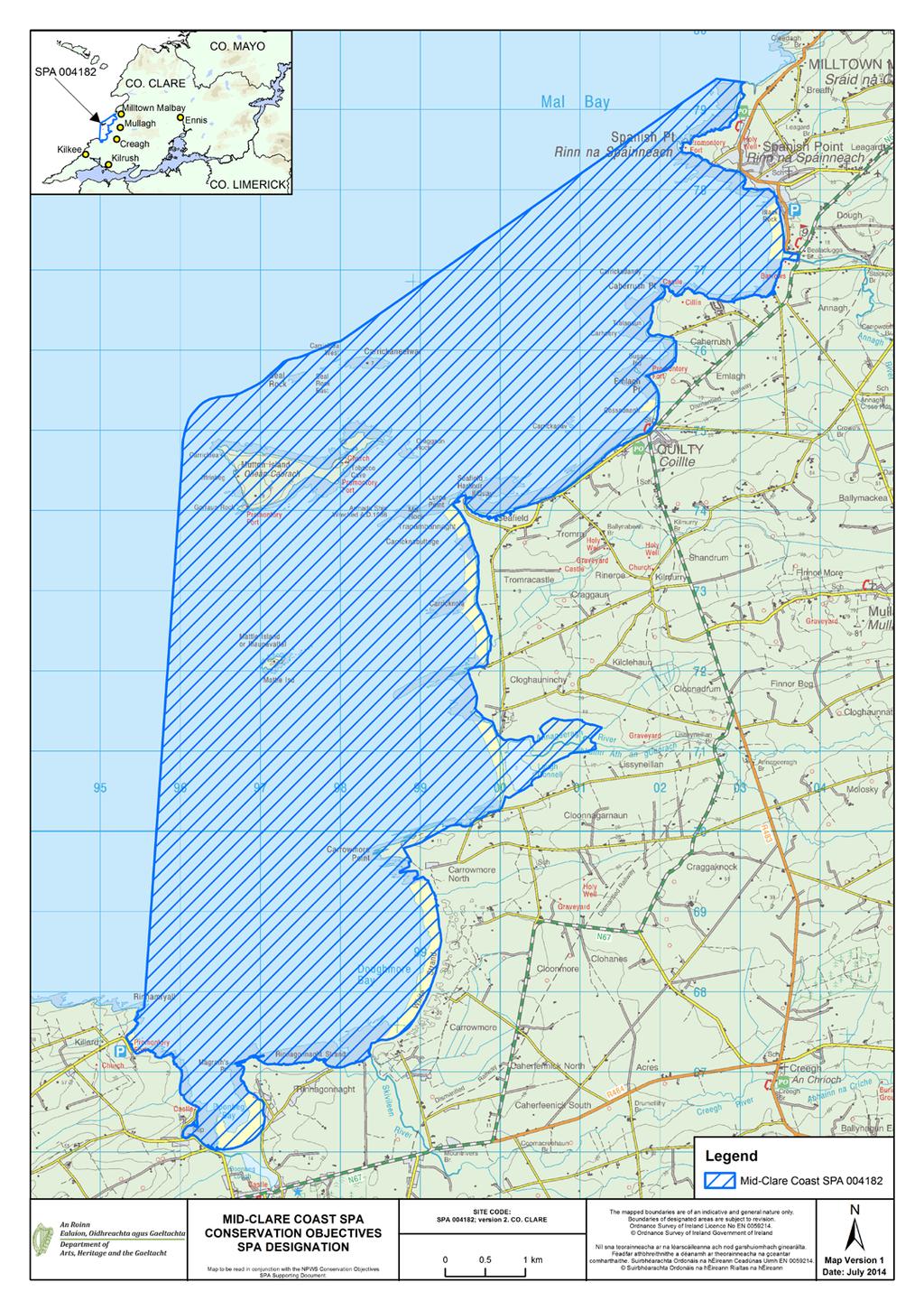
49 46
50 APPENDIX 2 Waterbird data sources Irish Wetland Bird Survey (I-WeBS) I-WeBS began in the Republic of Ireland in 1994/95 and aims to monitor wintering (non-breeding) waterbird populations at the wetland sites upon which they rely. Counts are carried out by volunteers and professional staff of the partner organisations across the months September to March of each year. I-WeBS counts take place on a rising tide or close to high tide. For further information please refer to Crowe (2005) and Boland & Crowe (2012). The I-WeBS Programme monitors the larger coastal wetland sites together with inland lakes, turloughs, rivers and callows. However the resulting dataset is incomplete for some waterbird species that utilise other habitats such as non-wetland habitat (e.g. grassland used by many species and particularly foraging geese, and swans), non-estuarine coastline, small and ephemeral wetlands and the open sea; the latter of which is obviously difficult to monitor from land-based surveys (Crowe, 2005). A number of additional and special surveys are therefore conducted on an annual or regular basis and data collected are, where appropriate, integrated into the I-WeBS database. These surveys include those undertaken for swan and geese species that forage typically during daylight hours across terrestrial habitats (e.g. grassland, arable fields) using coastal wetlands sites at night when they congregate to roost. Some of the additional surveys are carried out at certain times, aimed at providing a better estimate of numbers (e.g. Greylag Geese) and for some species an assessment of breeding success during the previous summer (e.g. Light-bellied Brent Geese). These surveys are introduced briefly below and more information is provided in Crowe (2005). Swan Surveys Coordinated international censuses are carried out of the wintering populations of Whooper Swan (Cygnus cygnus) and Bewick s Swan (Cygnus columbianus bewickii) at four or five-yearly intervals. The surveys are organised by I-WeBS, the Irish Whooper Swan Study group (IWSSG) and WWT. Greenland White-fronted Goose Greenland White-fronted Geese are concentrated at relatively few sites during winter, many of which are non-wetland habitats. The species is therefore not covered adequately by the I-WeBS programme. The Greenland White-fronted Goose census was initiated in the late 1970 s and is carried out by NPWS in Ireland and by JNCC and Scottish Natural Heritage (SNH) in Scotland. Greylag Geese Data for the Icelandic breeding population of Greylag Goose that winters in Ireland are taken from special surveys organised through I-WeBS and undertaken during November each year. The surveys aim to assess the distribution and status of the migratory flocks wintering in Ireland and focus on known feeding areas (grassland & agricultural land). When calculating population estimates of the Icelandic birds, data collected are adjusted to account for feral flocks that also occur within Ireland. Barnacle Goose (Branta leucopsis) A wintering population from the northeast Greenland breeding population winters mainly on offshore islands along the west coast of Ireland. An aerial survey of the principal wintering areas is carried out every five years in spring (late March/early April) with a few regularly-used mainland sites groundcounted simultaneously. The survey is coordinated in Scotland by the Wildfowl & Wetlands Trust (WWT) and in Ireland by the National Parks and Wildlife Service (NPWS). Light-bellied Brent Geese Special autumn surveys of this species have been conducted since 1996, organised in Ireland by the Irish Brent Goose Research Group (IBGRG). The survey is currently conducted on a bi-annual basis during the month of October which coincides with the autumn arrival of the species. Data collected are integrated into the I-WeBS database. 47
51 APPENDIX 3 Analysing population trends: a synopsis Monitoring of non-breeding waterbirds has been undertaken by the Irish Wetland Bird Survey (I-WeBS) and its partner, WeBS in Northern Ireland, since the mid 1990 s. For such long-term count data, there is clearly a need to assess long-term trends in a consistent and objective manner (Atkinson et al. 2006). The first stage in the analytical process involves the use of the Underhill Program (Underhill & Prŷs- Jones, 1994) which models the raw monthly counts using a Generalised Linear Model (GLM). As part of this process, it accounts for changes in numbers at the site and the timing of the count (month, year) while also taking into account completed counts and trends at other sites. When counts at a site are flagged as poor quality (e.g. due to poor visibility) or where there are missing values in a given month, then the modelled values are used. This imputation process is used widely to replace missing data points (e.g. Houlahan et al. 2000; Atkinson et al. 2006; Leech et al. 2002; Gregory et al. 2005; Crowe et al. 2008). The resulting dataset is therefore complete for all months and seasons and comprises a combination of actual count data and imputed count data. This complete dataset is then modelled using a Generalised Additive Models (GAM) which fits a smoothed curve to the counts. GAMs are non-parametric and flexible extensions of the generalised linear model where the linear predictor of the GLM is replaced by a general additive predictor which allows mean abundance to vary as a smooth function of time. Count data are assumed to follow independent Poisson distribution with 0.3T degrees of freedom (e.g. after Atkinson et al. 2006). The application of GAMs to analyse population trends was applied to UK farmland birds by Fewster et al. (2000) and has since been adopted for modelling waterbird trends elsewhere, for example, the UK WeBS Alert system (Leech et al. 2002). Smoothed count data for a site are then indexed to assess population trends over time. An index number can be defined as a measure of population size in one year expressed in relation to the size of the population in another selected year (Leech et al. 2002). Changes in the index numbers can therefore explain the pattern of population change over time (Underhill & Prŷs-Jones, 1994). Annual indices are calculated separately for each species at a site. For each year included in an analysis, a total is obtained by summing the number of birds present in a predetermined number of months. The final year in the series of totals is then scaled to equal 100 (please see example in table). Index values in any given year therefore represent the number of individuals relative to those present in the final year. As this process is the same across all species and all sites analysed it allows for some useful comparisons. Count Data Index Un-smoothed indices are also calculated and provide a means of examining ( eye-balling ) the variation across time and can also be used to provide a measure of the mean annual change over the entire period. However, the GAM extension to the methodology and resultant smoothed indices allows for the calculation of proportional change in population size between one season and another. This latter calculation is used in Section 4.2 whereby trends are calculated for the long-term 14-year period (1995/ /10) and the recent five-year period (2004/ /10). The values given represent the percentage change in index (population) values across the specified time period, calculated by subtracting the smoothed index value at the start of the time-frame (1995) from the smoothed index value in the reference year (2009):- Change = ((I y I x) / I x ) x 100 where I y is the index from the current year and I x is the index value at the start of the selected time period (see example below) The reference year is the penultimate year in the time series because, when smoothing, the GAM takes into account values from both the preceding and following year. The last value in the smoothed dataset (2010) is therefore likely to be the least robust because it has no following year. The final result is therefore % change in population size across a specified time period. Larger values indicate larger proportional changes in population size; positive values indicating relative increases while negative values indicate relative decreases over the specified time period. 48
52 Worked example Year Unsmoothed Smoothed Term Change 5YR YR ALL YR Further information on population indexing and trend analysis can be found in various references; for particular reference to waterbirds see Leech et al (2002) and Atkinson et al. (2006). For information on the UK WeBS Alerts system, please see Thaxter et al. (2010) and Cook et al. (2013). Limitations The months chosen for the calculation of population indices aim to reflect the months when the populations at a site are the most stable, excluding months when there may be fluctuations due to passage populations. Despite this, some datasets still present a high degree of variability or fluctuation both within and between years. Because of this, we assess each species separately and take into account where a species shows a history of wide fluctuations between years (within national dataset), or where a species naturally exhibits within-season fluctuations (e.g. species considered to have weak site faithfulness). Where necessary the results of the trend analysis are assigned necessary caution. A high proportion of imputed counts can limit the effectiveness of the analysis to aid in the interpretation of the dataset. Species for which 50% or more of the monthly count values are imputed are excluded from analysis. But sometimes the calculation of population change may involve a comparison between winters where, at least one has a value based on a high proportion of imputed data. Where data for adjacent winters are relatively complete this is not a serious concern because of the smoothing technique used. However, where data for a number of consecutive winters rely heavily on imputed data then the resulting result is considered less reliable (Thaxter et al. 2010). Where necessary the results of the trend analysis are assigned necessary caution. Despite the smoothing effects of the GAM analysis, interpretation of population trends may sometimes still be difficult. Therefore we calculate proportional change in the population across differing time periods (e.g. 12-year, 10-year and 5-year periods) to assess more effectively how the population has fared over time. 49
53 APPENDIX 4 Waterbird species codes AE Arctic Tern Sterna paradisaea BY Barnacle Goose Branta leucopsis BA Bar-tailed Godwit Limosa lapponica BE Bean Goose Anser fabalis BS Bewick s Swan Cygnus columbianus AS Black Swan Cygnus atratus BH Black-headed Gull Chroicocephalus ridibundus BN Black-necked Grebe Podiceps nigricollis BW Black-tailed Godwit Limosa limosa BV Black-throated Diver Gavia arctica BG Brent Goose Branta bernicla CG Canada Goose Branta canadensis CM Common Gull Larus canus CS Common Sandpiper Actitis hypoleucos CX Common Scoter Melanitta nigra CN Common Tern Sterna hirundo CO Coot Fulica atra CA Cormorant Phalacrocorax carbo CU Curlew Numenius arquata CV Curlew Sandpiper Calidris ferruginea DN Dunlin Calidris alpina GA Gadwall Anas strepera GP Golden Plover Pluvialis apricaria GN Goldeneye Bucephala clangula GD Goosander Mergus merganser GB Great Black-backed Gull Larus marinus GG Great Crested Grebe Podiceps cristatus ND Great Northern Diver Gavia immer NW Greenland White-fronted Goose Anser albifrons flavirostris GK Greenshank Tringa nebularia H. Grey Heron Ardea cinerea GV Grey Plover Pluvialis squatarola GJ Greylag Goose Anser anser HG Herring Gull Larus argentatus JS Jack Snipe Lymnocryptes minimus KF Kingfisher Alcedo atthis KN Knot Calidris canutus L. Lapwing Vanellus vanellus LB Lesser Black-backed Gull Larus fuscus PB Light-bellied Brent Goose Branta bernicla hrotra ET Little Egret Egretta garzetta 50
54 LG Little Grebe Tachybaptus ruficollis AF Little Tern Sterna albifrons MA Mallard Anas platyrhynchos MU Mediterranean Gull Larus melanocephalus MH Moorhen Gallinula chloropus MS Mute Swan Cygnus olor OC Oystercatcher Haematopus ostralegus PG Pink-footed Goose Anser brachyrhynchus PT Pintail Anas acuta PO Pochard Aythya ferina PS Purple Sandpiper Calidris maritima RM Red-breasted Merganser Mergus serrator RH Red-throated Diver Gavia stellata RK Redshank Tringa totanus RP Ringed Plover Charadrius hiaticula RU Ruff Philomachus pugnax SS Sanderling Calidris alba TE Sandwich Tern Sterna sandvicensis SP Scaup Aythya marila SU Shelduck Tadorna tadorna SV Shoveler Anas clypeata SY Smew Mergus albellus SN Snipe Gallinago gallinago NB Spoonbill Platalea leucorodia DR Spotted Redshank Tringa erythropus T. Teal Anas crecca TU Tufted Duck Aythya fuligula TT Turnstone Arenaria interpres WA Water Rail Rallus aquaticus WM Whimbrel Numenius phaeopus WG White-fronted Goose Anser albifrons WS Whooper Swan Cygnus Cygnus WN Wigeon Anas penelope WK Woodcock Scolopax rusticola 51
55 APPENDIX 5 Waterbird foraging guilds (after Weller, 1999) Guild Foods Tactics Examples (1) Surface swimmer Invertebrates, vegetation & seeds Strain/sieve/sweep/dabble/gr ab/up-ending Dabbling ducks ; e.g. Shoveler, Teal, Mallard, Pintail, Wigeon, Gadwall (2) Water column diver shallow a Fish & Invertebrates; Search/grab Diving ducks e.g. Pochard, Tufted Duck, Scaup, Eider, (3) Water column diver greater depths (4) Intertidal walker, out of water (5) Intertidal walker, out of water (6) Intertidal walker, in water (7) Terrestrial, walker (e.g. grassland/marsh) a dives <3m. Fish & Invertebrates Search/grab Common Scoter, divers, grebes, Cormorant Invertebrates Search (probe)/grab Sandpipers, plovers Invertebrates, vegetation Sieve/grab/graze Shelduck, Avocet, Spoonbill, Wigeon, Light-Bellied Brent Goose, Fish Search/strike Grey Heron Fish, Invertebrates Probe, scythe, sweep/grab Spoonbill, Greenshank Fish Stalk Little Egret Invertebrates Probe Several sandpiper species Vegetation (inc. roots, tubers & seeds) Graze, peck, probe Many geese species Please note that this table refers to generalised foraging strategies and is meant as a guide only. There is a great deal of variation between sites, seasons, tidal states and indeed, individual birds themselves. For example, some waterbird species may deploy several of the methods, e.g. Shelduck may forage by sieving intertidal mud (5) or by up-ending (1) and Pintail, although generally known as a dabbling duck, does occasionally dive for food. 52
56 APPENDIX 6 Mid-Clare Coast Waterbird Survey Programme 2010/11 Count Subsites Subsite Code Subsite name Subsite Area (ha) 0H095 Doonbeg Lough 7 0H402 Lough Donnell 13 0H403 Doonbeg Bay 88 0H538 Spanish Point 89 0H539 Black Rock (Sp.Point) 64 0H540 Caherush Pt (north) 125 0H541 Emlagh Pt. to Caherush Pt. 71 0H542 Seafield (Quilty) 176 0H543 Lurga Pt. (incl Craggaun Rock) 314 0H544 Carricknola (Tromracastle) 263 0H545 Mattle Is. to Garraun Rock 383 0H546 Carrowmore Pt to Cloghauninchy 265 0H547 White Strand 149 0H548 Rinnagonnaght Strand 69 0H549 Rinnamyrall 73 0H550 Rinnamyrall- Mattle Is. Offshore 958 0H551 Offshore Spanish Point
57 54

58 55
59 APPENDIX 7 Mid-Clare Coast Waterbird distribution (dot-density diagrams) recorded during low tide surveys (October 2010 February 2011) (NB data are presented for birds located in intertidal and subtidal habitats only) 56
60 57
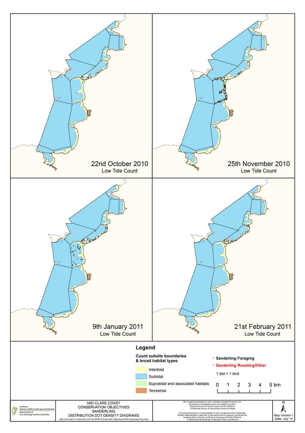
61 58
Trawbreaga Bay Special Protection Area. Conservation Objectives Supporting Document
 Trawbreaga Bay Special Protection Area (Site Code 4034) Conservation Objectives Supporting Document VERSION 1 National Parks & Wildlife Service February 2014 TABLE OF CONTENTS SUMMARY PART ONE - INTRODUCTION...
Castlemaine Harbour Special Protection Area. (Site Code 4029) Version 2. Conservation Objectives Supporting Document
 Version 2. Conservation Objectives Supporting Document") Castlemaine Harbour Special Protection Area (Site Code 4029) Version 2 Conservation Objectives Supporting Document National Parks & Wildlife Service March 2011 T A B L E O F C O N T E N T S PART ONE -
Castlemaine Harbour Special Protection Area (Site Code 4029) Version 2 Conservation Objectives Supporting Document National Parks & Wildlife Service March 2011 T A B L E O F C O N T E N T S PART ONE -
Malahide Estuary Special Protection Area. Conservation Objectives Supporting Document
 Malahide Estuary Special Protection Area (Site Code 4025) Conservation Objectives Supporting Document VERSION 1 National Parks & Wildlife Service August 2013 SUMMARY T A B L E O F C O N T E N T S PART
Tramore Back Strand Special Protection Area. Conservation Objectives Supporting Document
 Tramore Back Strand Special Protection Area (Site Code 4027) Conservation Objectives Supporting Document VERSION 1 National Parks & Wildlife Service September 2013 SUMMARY T A B L E O F C O N T E N T S
Baldoyle Bay Special Protection Area. Conservation Objectives Supporting Document
 Baldoyle Bay Special Protection Area (Site Code 4016) Conservation Objectives Supporting Document VERSION 1 National Parks & Wildlife Service December 2012 SUMMARY T A B L E O F C O N T E N T S PART ONE
Rogerstown Estuary Special Protection Area. Conservation Objectives Supporting Document
 Rogerstown Estuary Special Protection Area (Site Code 4015) Conservation Objectives Supporting Document VERSION 1 National Parks & Wildlife Service May 2013 T A B L E O F C O N T E N T S SUMMARY PART ONE
Donegal Bay Special Protection Area. Conservation Objectives Supporting Document
 Donegal Bay Special Protection Area (Site Code 4151) Conservation Objectives Supporting Document VERSION 1 National Parks & Wildlife Service January 2012 SUMMARY T A B L E O F C O N T E N T S PART ONE
Blacksod Bay/Broad Haven Special Protection Area. Conservation Objectives Supporting Document
 Blacksod Bay/Broad Haven Special Protection Area (Site Code 4037) Conservation Objectives Supporting Document VERSION 1 National Parks & Wildlife Service November 2014 SUMMARY T A B L E O F C O N T E N
North Bull Island Special Protection Area (Site Code 4006) South Dublin Bay and River Tolka Estuary Special Protection Area (Site Code 4024)
 South Dublin Bay and River Tolka Estuary Special Protection Area (Site Code 4024)") North Bull Island Special Protection Area (Site Code 4006) & South Dublin Bay and River Tolka Estuary Special Protection Area (Site Code 4024) Conservation Objectives Supporting Document VERSION 1 National
North Bull Island Special Protection Area (Site Code 4006) & South Dublin Bay and River Tolka Estuary Special Protection Area (Site Code 4024) Conservation Objectives Supporting Document VERSION 1 National
Cabra, Dublin 7. Appropriate assessment (screening) Report prepared for Crekav Trading GP Limited. November 2017
 Report prepared for Crekav Trading GP Limited. November 2017") Proposed development at Former CIE Lands, Carnlough Road, Cabra, Dublin 7 Appropriate assessment (screening) Report prepared for Crekav Trading GP Limited November 2017 Roger Goodwillie & Associates, Lavistown
Proposed development at Former CIE Lands, Carnlough Road, Cabra, Dublin 7 Appropriate assessment (screening) Report prepared for Crekav Trading GP Limited November 2017 Roger Goodwillie & Associates, Lavistown
The Effects on Waterbirds of Dredging at the Cardiff Bay Barrage Report for 2005/06
 The Effects on Waterbirds of Dredging at the Cardiff Bay Barrage Report for 2005/06 Authors N.H.K. Burton & S.J. Holloway Report of work carried out by The British Trust for Ornithology under contract
4.20 BLACKWATER ESTUARY
 4.20 BLACKWATER ESTUARY LTC site code: CB Centre grid: TL9507 JNCC estuarine review site: 112 Habitat zonation: 2368 ha intertidal, 1587 ha subtidal, 766 ha nontidal Statutory status: Blackwater Estuary
4.18 HAMFORD WATER. LTC site code:
 4.18 HAMFORD WATER LTC site code: BH Centre grid: TM2325 JNCC estuarine review site: 110 Habitat zonation: 367 ha intertidal, 106 ha subtidal, 58 ha nontidal Statutory status: Hamford Water SPA (UK9009131),
OFFICE OF ENVIRONMENTAL SUSTAINABILITY
 This report has been cleared for submission by David Flynn. Eve O'Sullivan, 13/03/2018 10:52 OFFICE OF ENVIRONMENTAL SUSTAINABILITY ENVIRONMENTAL LICENSING PROGRAMME TO: Eimear Cotter, Director FROM: Brian
BROADMEADOW RIVER ESTUARY (SWORDS/MALAHIDE), CO. DUBLIN
, CO. DUBLIN") BROADMEADOW RIVER ESTUARY (SWORDS/MALAHIDE), CO. DUBLIN WATERBIRDS IN JULY AND AUGUST 2008 (with additional counts from 2004-2008) Oscar J. Merne, M.Sc. Ornithologist & Environmental Scientist August 2008
BROADMEADOW RIVER ESTUARY (SWORDS/MALAHIDE), CO. DUBLIN WATERBIRDS IN JULY AND AUGUST 2008 (with additional counts from 2004-2008) Oscar J. Merne, M.Sc. Ornithologist & Environmental Scientist August 2008
THE MERSEY GATEWAY PROJECT (MERSEY GATEWAY BRIDGE) AVIAN ECOLOGY SUMMARY PROOF OF EVIDENCE OF. Paul Oldfield
 AVIAN ECOLOGY SUMMARY PROOF OF EVIDENCE OF. Paul Oldfield") HBC/14/3S THE MERSEY GATEWAY PROJECT (MERSEY GATEWAY BRIDGE) AVIAN ECOLOGY SUMMARY PROOF OF EVIDENCE OF Paul Oldfield 1 1 DESCRIPTION OF THE BIRDLIFE IN THE UPPER MERSEY ESTUARY LOCAL WILDLIFE SITE 1.1
HBC/14/3S THE MERSEY GATEWAY PROJECT (MERSEY GATEWAY BRIDGE) AVIAN ECOLOGY SUMMARY PROOF OF EVIDENCE OF Paul Oldfield 1 1 DESCRIPTION OF THE BIRDLIFE IN THE UPPER MERSEY ESTUARY LOCAL WILDLIFE SITE 1.1
National Parks and Wildlife Service
 ISSN 2009-4086 National Parks and Wildlife Service Conservation Objectives Series South Dublin Bay and River Tolka Estuary SPA 004024 Page 1 of 23 National Parks and Wildlife Service, Department of Arts,
JNCC estuarine review site: ha intertidal, 1024 ha subtidal, 541 ha nontidal
 4.56 DUDDON ESTUARY LTC site code: BD Centre grid: SD1977 JNCC estuarine review site: 39 Habitat zonation: 3589 ha intertidal, 1024 ha subtidal, 541 ha nontidal Statutory status: Duddon Estuary SPA (UK9005031),
James Latham (Ecological Consultant)
") Identification of wintering waterbird high tide roosts on the Severn Estuary SSSI/SPA (Brean Down to Clevedon) Date: 10 th July 2015 This report has been prepared for: Natural England By: James Latham
Identification of wintering waterbird high tide roosts on the Severn Estuary SSSI/SPA (Brean Down to Clevedon) Date: 10 th July 2015 This report has been prepared for: Natural England By: James Latham
3 March 2015 The Director Sustainable Fisheries Section Department of the Environment GPO Box 787 CANBERRA ACT 2601
 3 March 2015 The Director Sustainable Fisheries Section Department of the Environment GPO Box 787 CANBERRA ACT 2601 SustainableFisheries@environment.gov.au Dear Director, Birdlife Australia welcomes the
Branta leucopsis East Greenland/Scotland & Ireland
 Period 2008-2012 European Environment Agency European Topic Centre on Biological Diversity Branta leucopsis East Greenland/Scotland & Ireland Annex I International action plan Yes No Barnacle Goose, Branta
The Effect of the Cardiff Bay Barrage on Waterbird Populations Final Report
 The Effect of the Cardiff Bay Barrage on Waterbird Populations Final Report Authors N.H.K. Burton, M.M. Rehfisch & N.A. Clark Report of work carried out by The British Trust for Ornithology under contract
Office of Climate, Licensing & Resource Use Environmental Protection Agency PO Box 3000 County Wexford 3 August 2010
 Kilcatherine, Eyeries, County Cork http://www.friendsoftheirishenvironment.org Office of Climate, Licensing & Resource Use Environmental Protection Agency PO Box 3000 County Wexford 3 August 2010 Westland
STOUR ESTUARY Essex, Suffolk
 STOUR ESTUARY Essex, Suffolk Internationally important: Nationally important: Pintail, Grey Plover, Knot, Dunlin, Black-tailed Godwit, Redshank Great Crested Grebe, Dark-bellied Brent Goose, Shelduck,
Calidris alpina schinzii Britain & Ireland/SW Europe & NW Africa
 Period 2008-2012 European Environment Agency European Topic Centre on Biological Diversity Calidris alpina schinzii Britain & Ireland/SW Europe & NW Africa Annex I International action plan Yes No Dunlin,
Humber Management Scheme. Fact sheet: Wintering and passage birds
 Humber Management Scheme Fact sheet: Wintering and passage birds Introduction The Humber Estuary plays an international role in bird migration and is one of the most important wetland sites in the UK.
National Parks and Wildlife Service
 National Parks and Wildlife Service Conservation Objectives Series Wexford Harbour and Slobs SPA 004076 Page 1 of 39 National Parks and Wildlife Service, Department of Arts, Heritage and the Gaeltacht,
Assessing ornithological impacts associated with wind farm developments: surveying recommendations
 Assessing ornithological impacts associated with wind farm developments: surveying recommendations This information note has been written to provide guidance to developers, Competent Authorities and others
Branta leucopsis Russia/Germany & Netherlands
 Period 2008-2012 European Environment Agency European Topic Centre on Biological Diversity Branta leucopsis Russia/Germany & Netherlands Annex I International action plan Yes No Barnacle Goose, Branta
STANDARD DATA FORM FOR SPECIAL PROTECTION AREAS (SPA) FOR SITES ELIGIBLE FOR IDENTIFICATION AS SITES OF COMMUNITY IMPORTANCE (SCI) AND
 FOR SITES ELIGIBLE FOR IDENTIFICATION AS SITES OF COMMUNITY IMPORTANCE (SCI) AND") Start Form NF004005 Site code: NATURA 2000 STANDARD DATA FORM FOR SPECIAL PROTECTION AREAS (SPA) FOR SITES ELIGIBLE FOR IDENTIFICATION AS SITES OF COMMUNITY IMPORTANCE (SCI) AND FOR SPECIAL AREAS OF CONSERVATION
Start Form NF004005 Site code: NATURA 2000 STANDARD DATA FORM FOR SPECIAL PROTECTION AREAS (SPA) FOR SITES ELIGIBLE FOR IDENTIFICATION AS SITES OF COMMUNITY IMPORTANCE (SCI) AND FOR SPECIAL AREAS OF CONSERVATION
Dispersed Waterbirds Survey
 Dispersed Waterbirds Survey Title Dispersed Waterbird Survey 2002/03 Description and Summary of Results The main wetland sites are counted by the Wetland Bird Survey (WeBS) Core Counts -- monthly counts
HELCOM workshop on migratory waterbirds
 HELCOM workshop on migratory waterbirds Helsinki, 20-22 November 2018 Aims: Produce maps with migration routes of waterbird species (e.g. seabirds, ducks, waders) covering the entire Baltic Sea Region.
State of nature in the EU: results from the reporting under the nature directives
 State of nature in the EU: results from the reporting under the nature directives 2007-2012 18 th Meeting Co-ordination Group for Biodiversity and Nature 12 March 2015 1 EEA technical report Contents Introduction
BC Coastal Waterbird Survey Protocol. Instructions for Participants
 Instructions for Participants Background The coastal marine habitat of British Columbia is home to many species of waterbirds and supports some of the highest densities of seabirds, waterfowl, and shorebirds
APPENDIX 11.2 BRENT GEESE SURVEY REPORT
 APPENDIX 11.2 BRENT GEESE SURVEY REPORT Light-bellied Brent Goose presence on Alfie Byrne Road Green Space and Belcamp Park in Dublin City along route corridor for proposed aviation fuel pipeline SUMMARY
Calidris alpina schinzii Baltic/SW Europe & NW Africa
 Period 2008-2012 European Environment Agency European Topic Centre on Biological Diversity Calidris alpina schinzii Baltic/SW Europe & NW Africa Annex I International action plan Yes No Dunlin, Calidris
Summary of protection values of Finnish marine protection areas
 Appendix 5 Summary of protection values of Finnish marine protection areas s Table lists relevant Finnish Marine s in the vicinity of NSP2 project area and their conservation objectives. Sites are listed
BirdLife International Marine Programme Marine Important Bird & Biodiversity Areas (Marine IBAs)
") Photo: Pep Arcos BirdLife International Marine Programme Marine Important Bird & Biodiversity Areas (Marine IBAs) Marguerite Tarzia- Marine Conservation Officer, BirdLife Europe marguerite.tarzia@birdlife.org
Photo: Pep Arcos BirdLife International Marine Programme Marine Important Bird & Biodiversity Areas (Marine IBAs) Marguerite Tarzia- Marine Conservation Officer, BirdLife Europe marguerite.tarzia@birdlife.org
ADDENDUM 1. The River Shannon & River Fergus Estuaries. Waterbird data and SIFP Areas Non-Technical Summary
 ADDENDUM 1 The River Shannon & River Fergus Estuaries Waterbird data and SIFP Areas Non-Technical Summary This addendum provides summary waterbird data for the SIFP areas. Please see Section 3.5 of the
The Effect of the Cardiff Bay Barrage on Waterbird Populations 12. Distribution and Movement Studies August 2000-May 2001
 The Effect of the Cardiff Bay Barrage on Waterbird Populations 12. Distribution and Movement Studies August 2000-May 2001 Authors N.H.K. Burton, M.M. Rehfisch & N.A. Clark Report of work carried out by
Review and analysis of changes in waterbird use of the Mersey Estuary SPA, Mersey Narrows & North Wirral Foreshore pspa and Ribble & Alt Estuaries SPA
 Natural England Commissioned Report NECR173 Review and analysis of changes in waterbird use of the Mersey Estuary SPA, Mersey Narrows & North Wirral Foreshore pspa and Ribble & Alt Estuaries SPA First
Agreement on the Conservation of African-Eurasian Migratory Waterbirds (AEWA)
") Agreement on the Conservation of African-Eurasian Migratory Waterbirds (AEWA) A Tool for International Cooperation AEWA - An International Treaty Safeguarding Migratory Waterbirds The Agreement on the
Agreement on the Conservation of African-Eurasian Migratory Waterbirds (AEWA) A Tool for International Cooperation AEWA - An International Treaty Safeguarding Migratory Waterbirds The Agreement on the
PORTSMOUTH HARBOUR Hampshire
 PORTSMOUTH HARBOUR Hampshire Internationally important: Nationally important: None Dark-bellied Brent Goose, Red-breasted Merganser, Black-tailed Godwit Site description This large harbour in the Solent
Report to Inform an Appropriate Assessment for the Firth of Forth SPA
 Report to Inform an Appropriate Assessment for the Firth of Forth SPA November 2009 No part of this report may be copied or reproduced by any means without prior written permission from Jacobs Arup - Jacobs
WWT/JNCC/SNH Goose & Swan Monitoring Programme survey results 2005/06
 1. Abundance WWT/JNCC/SNH Goose & Swan Monitoring Programme survey results 2005/06 Whooper swan Cygnus cygnus The fifth international census of Whooper Swans wintering in Britain, Ireland and Iceland was
SoN 2015: Landmark report shows European biodiversity going lost at unacceptable rates: intensive agriculture main culprit
 Brussels, 20 May 2015 SoN 2015: Landmark report shows European biodiversity going lost at unacceptable rates: intensive agriculture main culprit Landmark report shows European biodiversity going lost at
WeBS Alerts 1998/99: Changes in numbers of wintering waterbirds in the United Kingdom at national, country and Special Protection Area (SPA) scales
 scales") WeBS s 1998/99: Changes in numbers of wintering waterbirds in the United Kingdom at national, country and Special Protection Area (SPA) scales Authors Philip W. Atkinson, Graham E. Austin, Niall H.K. Burton,
WeBS s 1998/99: Changes in numbers of wintering waterbirds in the United Kingdom at national, country and Special Protection Area (SPA) scales Authors Philip W. Atkinson, Graham E. Austin, Niall H.K. Burton,
Alca torda. Report under the Article 12 of the Birds Directive Period Annex I International action plan. No No
 Period 2008-2012 European Environment Agency European Topic Centre on Biological Diversity Annex I International action plan No No Razorbill,, is a species of colonial seabird found in unvegetated or sparsely
A Rising Tide: Conserving Shorebirds and Shorebird Habitat within the Columbia River Estuary
 A Rising Tide: Conserving Shorebirds and Shorebird Habitat within the Columbia River Estuary By Vanessa Loverti USFWS Migratory Birds and Habitat Programs, Portland, Oregon May 28, 2014 Outline of Talk
2008 San Francisco Bay Shorebird Census
 2008 San Francisco Bay Shorebird Census San Francisco Bay is a great place for shorebirds! The salt ponds, tidal flats, marshes and seasonal wetlands provide important habitat for over a million resident
JNCC estuarine review site: ha intertidal, 608 ha subtidal, 27 ha nontidal Statutory status: Winter waterbird interest:
 4.50 CONWY ESTUARY LTC site code: EC Centre grid: SH7976 JNCC estuarine review site: 32 Habitat zonation: 1009 ha intertidal, 608 ha subtidal, 27 ha nontidal Statutory status: N/A Winter waterbird interest:
APPENDIX 11O WINTERING SWAN AND GOOSE
 APPENDIX 11O WINTERING SWAN AND GOOSE Legislation The following legislation is the most relevant to whooper swan Cygnus cygnus and greylag geese Anser anser within the study area. The Conservation (Nature
Wetland Bird Survey (Core Counts)
") Wetland Bird Survey (Core Counts) Title Wetland Bird Survey (WeBS) Core Counts 1954 to present Description and Summary of Results The UK is known to hold large numbers of waterbirds in the non-breeding
Wetland Bird Survey (Core Counts) Title Wetland Bird Survey (WeBS) Core Counts 1954 to present Description and Summary of Results The UK is known to hold large numbers of waterbirds in the non-breeding
General report format, ref. Article 12 of the Birds Directive, for the report
 Annex 1: General report format, ref. Article 12 of the Birds Directive, for the 2008-2012 report 0. Member State Select the 2 digit code for your country, according to list to be found in the reference
Migratory Shorebird Conservation Action Plan
 Migratory Shorebird Conservation Action Plan The Migratory Shorebird Conservation Action Plan (MS CAP) has been developed by a broad range of stakeholders from all across the country and internationally
Waterbird Disturbance Mitigation Toolkit Informing Estuarine Planning & Construction Projects
 Waterbird Disturbance Mitigation Toolkit Informing Estuarine Planning & Construction Projects Click on the Photograph to Enter Authors: N Cutts K Hemingway & J Spencer Version 3.2, March 2013 Copyright
WATERBIRD MONITORING IN THE CONSERVATION ZONE OF THE CREERY WETLANDS. December 1998 to April 2004
 WATERBIRD MONITORING IN THE CONSERVATION ZONE OF THE CREERY WETLANDS December 1998 to April 2004 Prepared for: RPS Bowman Bishaw Gorham Pty Ltd, 290 Churchill Avenue, Subiaco, WA Prepared by: M.J. & A.R.
Results of the third Non-Estuarine Waterbird Survey, including Population Estimates for Key Waterbird Species
 Results of the third Non-Estuarine Waterbird Survey, including Population Estimates for Key Waterbird Species Authors Graham Austin, Teresa Frost, Heidi Mellan, Dawn Balmer Report of work carried out by
LOCH LEVEN NATIONAL NATURE RESERVE (NNR) Proposed Local Access Guidance
 Proposed Local Access Guidance") LOCH LEVEN NATIONAL NATURE RESERVE (NNR) Proposed Local Access Guidance Summary This paper briefly outlines the rationale behind the proposed local access guidance for Loch Leven NNR. Introduction SNH
LOCH LEVEN NATIONAL NATURE RESERVE (NNR) Proposed Local Access Guidance Summary This paper briefly outlines the rationale behind the proposed local access guidance for Loch Leven NNR. Introduction SNH
The UK Wintering Waterbird Indicator: New developments towards a more comprehensive assessment of trends in the wintering waterbird assemblage
 The UK Wintering Waterbird Indicator: New developments towards a more comprehensive assessment of trends in the wintering waterbird assemblage Authors G. E. Austin, A. N. Banks & M. M. Rehfisch A report
Local regional, national and international importance of the wader populations of the Dee Estuary and at Point of Ayr, Clwyd
 BTO Research Report No 88 Local regional, national and international importance of the wader populations of the Dee Estuary and at Point of Ayr, Clwyd A report by the British Trust for Ornithology to Nicholas
Assessment of Supporting Habitat (Docks) for Use by Qualifying Features of Natura 2000 Sites in the Liverpool City Region
 for Use by Qualifying Features of Natura 2000 Sites in the Liverpool City Region") Assessment of Supporting Habitat (Docks) for Use by Qualifying Features of Natura 000 Sites in the Liverpool City Region Ornithology Report Report Ref: 457.005 August 05 Assessment of Supporting Habitat
Assessment of Supporting Habitat (Docks) for Use by Qualifying Features of Natura 000 Sites in the Liverpool City Region Ornithology Report Report Ref: 457.005 August 05 Assessment of Supporting Habitat
Farr wind farm: A review of displacement disturbance on dunlin arising from operational turbines
 Farr wind farm: A review of displacement disturbance on dunlin arising from operational turbines 2002-2015. Alan H Fielding and Paul F Haworth September 2015 Haworth Conservation Haworth Conservation Ltd
BLACKWATER ESTUARY Essex
 BLACKWATER ESTUARY Essex Internationally important: Nationally important: Dark-bellied Brent Goose, Golden Plover, Grey Plover, Dunlin, Black-tailed Godwit, Redshank Cormorant, Shelduck, Wigeon, Teal,
Site Improvement Plan. Ouse Washes SPA. Improvement Programme for England's Natura 2000 Sites (IPENS) Planning for the Future
 Planning for the Future") Improvement Programme for England's Natura 2000 Sites (IPENS) Planning for the Future Site Improvement Plan Ouse Washes Site Improvement Plans (SIPs) have been developed for each Natura 2000 site in England
Improvement Programme for England's Natura 2000 Sites (IPENS) Planning for the Future Site Improvement Plan Ouse Washes Site Improvement Plans (SIPs) have been developed for each Natura 2000 site in England
HABITATS REGULATIONS ASSESSMENT St. Anne s on the Sea Neighbourhood Plan Addendum to Screening Opinion OCTOBER 2016
 HABITATS REGULATIONS ASSESSMENT St. Anne s on the Sea Neighbourhood Plan Addendum to Screening Opinion OCTOBER 2016 CONTACTS JO WEAVER Senior Ecologist dd +44 (0)1453 423124 m +44 (0)7809 549186 e jo.weaver@arcadis.com
Waterbirds in the UK SURVEY METHODS WeBS Core Counts
 Waterbirds in the UK SURVEY METHODS The main source of data for this report is the WeBS scheme, providing regular monthly counts for most waterbird species at the majority of the UK s important wetlands.
LOUTH COUNTY COUNCIL. DRAFT LOCAL ECONOMIC & COMMUNITY PLAN Appropriate Assessment (AA) Screening Report DRAFT LECP
 Screening Report DRAFT LECP") LOUTH COUNTY COUNCIL DRAFT LOCAL ECONOMIC & COMMUNITY PLAN 2016-2022 Appropriate Assessment (AA) Screening Report A Plan for the promotion of economic and community development in County Louth TABLE OF
LOUTH COUNTY COUNCIL DRAFT LOCAL ECONOMIC & COMMUNITY PLAN 2016-2022 Appropriate Assessment (AA) Screening Report A Plan for the promotion of economic and community development in County Louth TABLE OF
Ruddy Turnstone. Appendix A: Birds. Arenaria interpres [M,W] New Hampshire Wildlife Action Plan Appendix A Birds-50
![Ruddy Turnstone. Appendix A: Birds. Arenaria interpres [M,W] New Hampshire Wildlife Action Plan Appendix A Birds-50](/thumbs/89/101188544.jpg "Ruddy Turnstone. Appendix A: Birds. Arenaria interpres [M,W] New Hampshire Wildlife Action Plan Appendix A Birds-50") Ruddy Turnstone Arenaria interpres [M,W] Federal Listing State Listing Global Rank State Rank Regional Status N/A N/A G5 SNR Very High Photo by Pamela Hunt Justification (Reason for Concern in NH) Populations
Ruddy Turnstone Arenaria interpres [M,W] Federal Listing State Listing Global Rank State Rank Regional Status N/A N/A G5 SNR Very High Photo by Pamela Hunt Justification (Reason for Concern in NH) Populations
CORE MANAGEMENT PLAN INCLUDING CONSERVATION OBJECTIVES FOR
 CYNGOR CEFN GWLAD CYMRU COUNTRYSIDE COUNCIL FOR WALES CORE MANAGEMENT PLAN INCLUDING CONSERVATION OBJECTIVES FOR TRAETH LAFAN/LAVAN SANDS, CONWAY BAY SPA (incorporating a section of Y Fenai a Bae Conwy/Menai
30 October PIRSA Fisheries and Aquaculture Attention Commercial Fishing GPO Box 1625 Adelaide SA
 30 October 2015 PIRSA Fisheries and Aquaculture Attention Commercial Fishing GPO Box 1625 Adelaide SA 5001 annabel.jones@sa.gov.au Dear Ms Jones Birdlife Australia and the Australasian Wader Studies Group
Roberts Bank Terminal 2 Project Field Studies Information Sheet
 January 2013 Port Metro Vancouver is continuing field studies in January as part of ongoing environmental and technical work for the proposed. The is a proposed new multi berth container terminal which
Bird Sensitivity Mapping for wind energy developments in Ireland Development & Implementation of the mapping tool. birdwatchireland.
 Bird Sensitivity Mapping for wind energy developments in Ireland Development & Implementation of the mapping tool birdwatchireland.ie Guidance document Detailed guidance document Requirement for mapping
Sanderling. Appendix A: Birds. Calidris alba. New Hampshire Wildlife Action Plan Appendix A Birds-67
 Sanderling Calidris alba Federal Listing State Listing Global Rank State Rank Regional Status N/A N/A G5 SNR High Photo by Pamela Hunt Justification (Reason for Concern in NH) Populations of several migratory
The Wetland Bird Survey (WeBS) is the monitoring scheme for non-breeding waterbirds in the UK which aims to provide the principal data for the
 is the monitoring scheme for non-breeding waterbirds in the UK which aims to provide the principal data for the") The Wetland Bird Survey (WeBS) is the monitoring scheme for non-breeding waterbirds in the UK which aims to provide the principal data for the conservation of their populations and wetland habitats. WeBS
The Wetland Bird Survey (WeBS) is the monitoring scheme for non-breeding waterbirds in the UK which aims to provide the principal data for the conservation of their populations and wetland habitats. WeBS
Catalog of Upper Mississippi River and Great Lakes Region Joint Venture GIS Data March 2009 Version 1
 Catalog of Upper Mississippi River and Great Lakes Region Joint Venture GIS Data March 2009 Version 1 Compiled by: Bradly Potter Introduction This catalog contains descriptions of GIS data available from
North Solent Shoreline Management Plan. Appendix J: Appropriate Assessment
 North Solent Shoreline Management Plan Appendix J: Appropriate Assessment Contents Page No J1 INTRODUCTION...1 J1.1 Background...1 J1.2 Role of Organisations in the Appropriate Assessment Process...8
Project Summary. Predicting waterbird nest distributions on the Yukon-Kuskokwim Delta of Alaska
 Project Summary 1. PROJECT INFORMATION Title Project ID Predicting waterbird nest distributions on the Yukon-Kuskokwim Delta of Alaska WA2012_22 Project Period July 1, 2012 to June 30, 2014 Report submission
Species of Greatest Conservation Need Priority Species for NYC Audubon. May 12, Susan Elbin Director of Conservation and Science
 Species of Greatest Conservation Need Priority Species for NYC Audubon May 12, 2011 Susan Elbin Director of Conservation and Science Working List of Species Species on the current federal or state list
Impact of wind farms on birds and bats
 Impact of wind farms on birds and bats Dr. Hermann Hötker Michael-Otto-Institut im NABU BirdLife Partner Germany Methods Disturbance and Displacement Collision mortality Repowering download: http://bergenhusen.nabu.de/bericht/voegelregenergien.pdf
Interim Project Report: Year One
 Interim Project Report: Year One Deborah Whitfield October 2017 Hampshire and Isle of Wight Wildlife Trust 1 Publication Details This document should be cited as: Whitfield, D (2017) Solent Waders and
SPECIES ACTION PLAN. Rhinolophus ferrumequinum 1 INTRODUCTION 2 CURRENT STATUS 3 CURRENT FACTORS AFFECTING 4 CURRENT ACTION
 GREATER HORSESHOE BAT Rhinolophus ferrumequinum Hampshire Biodiversity Partnership 1 INTRODUCTION The greater horseshoe bat has been identified by the UK Biodiversity steering group report as a species
Working with wildlife A DAY IN THE LIFE
 EPA ACTIVITY WORKSHEET STUDENT PAGE 1 7 Theme Student Sheet. This is the story of a scientist and their work on a day to day basis. Objectives To give students an insight into the work of scientists and
National Parks and Wildlife Service
 ISSN 2009-4086 National Parks and Wildlife Service Conservation Objectives Series Pouladatig Cave SAC 000037 Page 1 of 8 National Parks and Wildlife Service, Department of Culture, Heritage and the Gaeltacht,
STRATEGIC ENVIRONMENTAL ASSESSMENT SCREENING STATEMENT MAINTENANCE ACTIVITIES COASTAL PROTECTION SCHEMES OFFICE OF PUBLIC WORKS ENGINEERING SERVICES
 STRATEGIC ENVIRONMENTAL ASSESSMENT SCREENING STATEMENT MAINTENANCE ACTIVITIES OF COASTAL PROTECTION SCHEMES UNDER THE RESPONSIBILITY OF THE OFFICE OF PUBLIC WORKS ENGINEERING SERVICES OFFICE OF PUBLIC
National Parks and Wildlife Service
 ISSN 2009-4086 National Parks and Wildlife Service Conservation Objectives Series Glanlough Woods SAC 002315 Page 1 of 7 National Parks and Wildlife Service, Department of Culture, Heritage and the Gaeltacht,
The Newsletter of the Irish Wetland Bird Survey Issue 16 August 2012
 I-WeBS News The Newsletter of the Irish Wetland Bird Survey Issue 16 August 2012 Oystercatcher breaking open a blue mussel. SHAY CONNOLLY The 2012/13 I-WeBS season The 2012/13 winter will be the 19th season
Site Improvement Plan. Solway Firth SAC. Improvement Programme for England's Natura 2000 Sites (IPENS) Planning for the Future
 Planning for the Future") Improvement Programme for England's Natura 2000 Sites (IPENS) Planning for the Future Site Improvement Plan Solway Firth Site Improvement Plans (SIPs) have been developed for each Natura 2000 site in England
Improvement Programme for England's Natura 2000 Sites (IPENS) Planning for the Future Site Improvement Plan Solway Firth Site Improvement Plans (SIPs) have been developed for each Natura 2000 site in England
Habitat changes force waterfowl to flee the coast by large amount
 Habitat changes force waterfowl to flee the coast by large amount BY: SHANNON TOMPKINS HOUSTON CHRONICLE MARCH 2, 2016 Photo: Picasa While the Texas coast still winters the majority of the continent's
Introducing an important new WSG publication on the status of migratory wader populations in Africa and western Eurasia in the 1990s
 Introducing an important new WSG publication on the status of migratory wader populations in Africa and western Eurasia in the 1990s DAVID STROUD & NICK DAVIDSON 2 Spring Meadows, Taylors Green, Warmington,
is selected to co-ordinate the counts at the site level and to provide a single point of contact for the national organiser. At the end of a winter, c
 2 Methods SITE SELECTION The scope of the WeBS Low Tide Counts (LTCs) is estuarine sites throughout the United Kingdom. When the LTCs were originally planned, the aim was to systematically census each
saline lagoons - Conserving saline lagoons & their birds on ten Natura 2000 sites in England LIFE99 NAT/UK/006086
 saline lagoons - Conserving saline lagoons & their birds on ten Natura 2000 sites in England LIFE99 NAT/UK/006086 Project description Environmental issues Beneficiaries Administrative data Read more Contact
4.12 NORTH NORFOLK COAST
 4.12 NORTH NORFOLK COAST LTC site code: CN Centre grid: TF8946 JNCC estuarine review site: 102 Habitat zonation: 3447 ha intertidal, 2490 ha subtidal, 2701 ha nontidal Statutory status: North Norfolk Coast
Roberts Bank Terminal 2 Project Field Studies Information Sheet
 May 2013 Port Metro Vancouver is continuing field studies in May as part of ongoing environmental and technical work for the proposed Roberts Bank Terminal 2 Project. Roberts Bank Terminal 2 Project The
Site Improvement Plan. Upper Nene Valley Gravel Pits SPA. Improvement Programme for England's Natura 2000 Sites (IPENS) Planning for the Future
 Planning for the Future") Improvement Programme for England's Natura 2000 Sites (IPENS) Planning for the Future Site Improvement Plan Upper Nene Valley Gravel Pits Site Improvement Plans (SIPs) have been developed for each Natura
Improvement Programme for England's Natura 2000 Sites (IPENS) Planning for the Future Site Improvement Plan Upper Nene Valley Gravel Pits Site Improvement Plans (SIPs) have been developed for each Natura
WeBS Alerts 1999/2000: Changes in Numbers of Wintering Waterbirds in the United Kingdom at National, Country and SSSI Scales
 WeBS Alerts 1999/2000: Changes in Numbers of Wintering Waterbirds in the United Kingdom at National, Country and SSSI Scales Interim Report Authors Philip W. Atkinson, Mark M. Rehfisch & Mark Pollitt Data
Anthony Gonzon DE Division of Fish & Wildlife DNREC
 Anthony Gonzon DE Division of Fish & Wildlife DNREC Thousands of birds migrate through Delaware every Fall Fall migration Sept Nov Thousands more call Delaware home in winter Nov Mar Wide-ranging diversity
MONITORING DIVERSITY AND ABUNDANCE OF WETLAND BIRDS. Chris Healey President, BirdLife East Gippsland
 MONITORING DIVERSITY AND ABUNDANCE OF WETLAND BIRDS Chris Healey President, BirdLife East Gippsland GIPPSLAND LAKES IMPORTANT BIRD AREA Ramsar site & Important Bird Area (GLIBA) Recognised under international
THE PROPOSED DUBLIN ARRAY WIND FARM ASSESSMENT OF POTENTIAL IMPACTS ON SEABIRDS
 THE PROPOSED DUBLIN ARRAY WIND FARM ASSESSMENT OF POTENTIAL IMPACTS ON SEABIRDS Information in support of the Appropriate Assessment of the proposed Wind Farm Report for: Prepared by: February 2013. THE
SHOREBIRD CENSUS STUDIES IN BRITAIN
 Studies in Avian Biology No. 2:157-166, 1979. SHOREBIRD CENSUS STUDIES IN BRITAIN A. J. PRATER ABSTRACT.-studies on shorebirds in Britain and Europe involve the combination of extensive census and intensive