Blacksod Bay/Broad Haven Special Protection Area. Conservation Objectives Supporting Document
|
|
|
- Ezra Matthews
- 6 years ago
- Views:
Transcription
1 Blacksod Bay/Broad Haven Special Protection Area (Site Code 4037) Conservation Objectives Supporting Document VERSION 1 National Parks & Wildlife Service November 2014
2 SUMMARY T A B L E O F C O N T E N T S PART ONE - INTRODUCTION Introduction to the designation of Special Protection Areas Introduction to Blacksod Bay /Broad Haven Special Protection Area Introduction to Conservation Objectives... 3 PART TWO SITE DESIGNATION INFORMATION Special Conservation Interests of Blacksod Bay/ Broad Haven Special Protection Area 5 PART THREE - CONSERVATION OBJECTIVES FOR BLACKSOD BAY/BROAD HAVEN SPA Conservation Objectives for the non-breeding Special Conservation Interests of Blacksod Bay/Broad Haven SPA... 8 PART FOUR REVIEW OF THE CONSERVATION STATUS OF WATERBIRD INTEREST FEATURES Population data for non-breeding waterbird SCI species of Blacksod Bay/Broad Haven SPA Waterbird population trends at Blacksod Bay / Broad Haven SPA Blacksod Bay /Broad Haven SPA site conservation status of non-breeding waterbirds16 PART FIVE SUPPORTING INFORMATION Introduction Waterbird species Ecological characteristics, requirements and specialities summary information The 2009/10 waterbird survey programme Introduction Waterbird distribution data and analyses Summary Results Waterbird distribution Blacksod Bay/Broad Haven - Activities and Events Introduction Assessment Methods Overview of activities at Blacksod Bay/Broad Haven Disturbance Assessment Discussion REFERENCES APPENDIX APPENDIX APPENDIX APPENDIX APPENDIX APPENDIX APPENDIX APPENDIX APPENDIX APPENDIX
3 SUMMARY This document presents conservation objectives for the non-breeding Special Conservation Interests of Blacksod Bay/Broad Haven Special Protection Area, designated under Directive 2009/147/EC on the conservation of wild birds (Birds Directive). Part One presents an introduction to the Special Protection Area (SPA) designation process and to the site designated as Blacksod Bay/Broad Haven Special Protection Area, as well as introducing the concept of conservation objectives and their formulation. Part Two provides site designation information for Blacksod Bay/Broad Haven SPA and Part Three presents the conservation objectives for this site. Part Four reviews the conservation condition of the site Special Conservation Interest (SCI) species based on an analysis of wintering (non-breeding) population trends. Importantly, this section states the current conservation condition of each of the SCI species and examines these site trends in light of all-ireland and international status and trends. Part Five provides supporting information that will assist the interpretation of the site-specific conservation objectives. This section includes a review of the ecological characteristics of the SCI species and examines waterbird distribution recorded during the 2009/10 Waterbird Survey Programme, drawing also on data from NPWS monitoring programmes (e.g. benthic surveys) and the Irish Wetland Bird Survey (I-WeBS). Part Five concludes with information on activities and events that occur in and around the site which may interact with waterbirds during the nonbreeding season and includes an assessment of those activities that were recorded to cause disturbance to non-breeding waterbirds during the 2009/10 Waterbird Survey Programme.
4 PART ONE - INTRODUCTION 1.1 Introduction to the designation of Special Protection Areas The over-arching framework for the conservation of wild birds within Ireland and across Europe is provided by Directive 2009/147/EC on the conservation of wild birds (the codified version of Council Directive 79/409/EEC as amended) (Birds Directive). Together with the EU Habitats Directive (Council Directive 92/43/EEC), these legislative measures provide for wild bird protection via a network of protected sites across Europe known as Natura 2000 sites, of which the overriding conservation objective is the maintenance (or restoration) of favourable conservation status of habitats and species. Under Article 4 of Directive 2009/147/EC, Ireland, along with other Member States, is required to classify the most suitable territories in number and size as Special Protection Areas (SPAs) for the conservation of certain wild bird species, which are: species listed in Annex I of the directive regularly occurring migratory species Also under Article 4, Member States are required to pay particular attention to the protection of wetlands, especially those of international importance. The National Parks & Wildlife Service (NPWS), part of the Department of the Arts, Heritage and the Gaeltacht, are responsible for the selection and designation of SPAs in Ireland. NPWS have developed a set of criteria, incorporating information relating to the selection of wetland sites developed under the Ramsar Convention, which are used to identify and designate SPAs. Sites that meet any of the following criteria may be selected as SPAs: A site regularly supporting 20,000 waterbirds or 10,000 pairs of seabirds; A site regularly supporting 1% or more of the all-ireland population of an Annex I species; A site regularly supporting 1% or more of the biogeographical population of a migratory species; A site that is one of the n most suitable sites in Ireland for an Annex I species or a migratory species (where n is a variable which is related to the proportion of the total biogeographic population of a species held by Ireland). The biogeographic population estimates and the recommended 1% thresholds for wildfowl and waders are taken from Wetlands International (Wetlands International, 2002); thresholds reflecting the baseline data period used. The all-ireland populations for the majority of wintering waterbirds are taken from Crowe et al. (2008). Site specific information relevant to the selection and designation of a SPA is collated from a range of sources including the Irish Wetland Bird Survey (I-WeBS), The Wetland Bird Survey (WeBS) in Northern Ireland, species specific reports and a wide range of scientific publications, reports and other surveys. If, following collation of all the available scientific data, a site meets the relevant criteria for designation and is selected as an SPA, a list of species for which the site is nationally and internationally important is compiled. These species are known as Special Conservation Interests and may be one of the following: An Annex I species that occurs at the site in numbers that exceed the all-ireland 1% population threshold; 1
5 A migratory species that occurs at the site in numbers that exceed the biogeographic 1% population threshold (referred to as a species that occurs in numbers of international importance ); A migratory species that occurs at the site in numbers that exceed the all-ireland 1% threshold (referred to as a species that occurs in numbers of all-ireland importance ); A species for which the site is considered to be one of the n most suitable sites in Ireland for the conservation of that species (where n is a variable that is related to the proportion of the total biogeographic population held by Ireland). Wetlands and waterbirds: the wetlands of northwest Europe are a vital resource for millions of northern and boreal nesting waterbird species that overwinter on these wetlands or visit them when migrating further south. To acknowledge the importance of Ireland's wetlands to wintering waterbirds the term Wetland & Waterbirds can be included as a Special Conservation Interest for a Special Protection Area that has been designated for wintering waterbirds, and is or contains a wetland site of significant importance to one or more of the species of Special Conservation Interest. 1.2 Introduction to Blacksod Bay /Broad Haven Special Protection Area Blacksod Bay /Broad Haven SPA is a large coastal Special Protection Area located in north-west County Mayo. Broad Haven and Blacksod Bays are large, sheltered and mostly shallow inlets which stretch north and south respectively, of the causeway linking the mainland to the Mullet Peninsula. The north-facing Broad Haven Bay is 10km wide at its mouth and extends south towards its head at Belmullet to provide habitats sheltered from the prevailing winds and wave action. The inner sections of the bay form part of the overall SPA site, extending southwards from close to Glash Island towards Belmullet Town. Sheltered estuaries Trawkirtan Bay in the east and Sruwaddacon Bay to the north-east are also included within the SPA, together with the narrow sea inlet Blind Harbour to the west. The southern section of the SPA comprises the various sheltered bays and inlets of Blacksod Bay, including Trawmore Bay and Claggan Strand, Saleen Harbour, Aghleam Bay and Doolough Bay and Strand. In the south-east, Tullaghan Bay is included as an integral part of the site. In the west, Elly Harbour is located adjacent to extensive dune habitat with saltmarsh that extends to surround Leam Lough, a small circular bay that resembles a freshwater lake but is in fact connected to Elly Harbour via a channel. Also included within the site are two small lakes, Cross Lough and Fahy Lough, and some areas of machair at Fahy, Doolough, Dooyork and Srah. Intertidal habitats of Blacksod Bay/Broad Haven SPA are largely dominated by sandy substrates although a range of sediment particle sizes are found across the whole site including coarse mixed sediments and shingle. Mudflats are found in more sheltered areas where river systems enter the marine environment (e.g. inner sections of Tullaghan Bay and Sruwaddacon Bay and near Belmullet) whereas the more open nature of Elly Harbour, Doolough Bay, and Aghleam Bay results in sandflats backed by extensive sand dune systems. The site contains saltmarsh habitats including Annex I habitats: Salicornia flats, Atlantic salt meadows and Mediterranean salt meadows; good examples being found within Elly Harbour, Trawmore Bay and Doolough Bay. A Zostera marina community is recorded in inner Broad Haven Bay from north of Knocknalina to Shanaghy Point and off Moynahan Point as well as off the eastern shore of the channel at Inver. 2
6 In Blacksod Bay Zostera marina is recorded at Trawmore Bay and Ardmore, on its western margins from Nomeenboy Point to Barranagh Island, to the west of Barranagh Island and to the north of both Ardelly Point and Moyrahan Point (NPWS, 2014 a,b). The SPA is surrounded by a variety of habitats of conservation value. Peatland habitats are well represented and particularly around Sruwaddacon Bay where they form part of the Glenamoy Bog Complex Special Area of Conservation (SAC 00500). Other terrestrial habitats are often associated with low-intensity agriculture but there is a predominance of coastal habitats including coastal grasslands, dune systems and machair, which include Annex I priority habitats and form part of areas designated as the Mullet/Blacksod Complex Special Area of Conservation (SAC 00470) and Broadhaven Bay Special Area of Conservation (SAC 00472). These SACs also include the marine areas of Broadhaven and Blacksod Bays. The SPA Site Synopsis and a map showing the SPA boundary are given in Appendix Introduction to Conservation Objectives The overriding objective of the Habitats Directive is to ensure that the habitats and species covered achieve favourable conservation status and that their long-term survival is secured across their entire natural range within the EU (EU Commission, 2012). In its broadest sense, favourable conservation status means that an ecological feature is being maintained in a satisfactory condition, and that this status is likely to continue into the future. Definitions as per the EU Habitats Directive are given in Box 1. Box 1 Favourable Conservation Status as defined by Articles 1 (e) and 1(i) of the Habitats Directive The conservation status of a natural habitat is the sum of the influences acting on it and its typical species that may affect its long-term natural distribution, structure and functions as well as the long-term survival of its typical species. The conservation status of a natural habitat will be taken as favourable when: its natural range and areas it covers within that range are stable or increasing; and the specific structure and functions which are necessary for its long-term maintenance exist and are likely to continue to exist for the foreseeable future; and the conservation status of its typical species is favourable. The conservation status of a species is the sum of the influences acting on the species that may affect the long-term distribution and abundance of its populations. The conservation status will be taken as favourable when: the population dynamics data on the species concerned indicate that it is maintaining itself on a long-term basis as a viable component of its natural habitats; and the natural range of the species is neither being reduced nor is likely to be reduced for the foreseeable future; and there is, and will probably continue to be, a sufficiently large habitat to maintain its populations on a long-term basis. Site-specific conservation objectives define the desired condition or range of conditions that a habitat or species should be in, in order for these selected features within the site to be judged as favourable. At site level, this state is termed favourable conservation condition. Site conservation objectives also contribute to the achievement of the wider goal of biodiversity 3
7 conservation at other geographic scales, and to the achievement of favourable conservation status at national level and across the Natura 2000 network 1. For coastal SPA sites, conservation objectives are defined for attributes 2 relating to non-breeding waterbird 3 species populations, and for attributes related to the maintenance and protection of habitats that support them. These attributes are: Population trend; Population distribution; Habitat range and area (extent). Further guidance is given in Section 3.1 (Conservation Objectives for the Special Conservation Interests of Blacksod Bay/Broad Haven Special Protection Area). 1 Note that the terms conservation condition and conservation status are used to distinguish between site and the national level objectives respectively. 2 Attribute can be defined as: a characteristic of a habitat, biotope, community or population of a species which most economically provides an indication of the condition of the interest feature to which it applies (JNCC, 1998). 3 Note that conservation objectives for the breeding species Dunlin (Calidris alpina schinzii) and Sandwich Tern (Sterna sandvicensis) are not presented here. 4
8 PART TWO SITE DESIGNATION INFORMATION 2.1 Special Conservation Interests of Blacksod Bay/ Broad Haven Special Protection Area The Special Conservation Interest species 4 for Blacksod Bay/Broad Haven SPA are listed below and summarised in Table 2.1. This table also shows the importance of the site for its SCI species, relative to the importance of other sites within Ireland, within the West region and within County Mayo. The Special Conservation Interests listed for Blacksod Bay/Broad Haven SPA are as follows:- 1. During winter the site regularly supports 1% or more of the biogeographical population of Light-bellied Brent Goose (Branta bernicla hrota). The mean peak number of this species within the SPA during the baseline period (1999/ /04) was 279 individuals. 2. During winter the site regularly supports 1% or more of the all-ireland population of Common Scoter (Melanitta nigra). The mean peak number of this species within the SPA during the baseline period (1999/ /04) was 510 individuals. 3. During winter the site regularly supports 1% or more of the all-ireland population of Redbreasted merganser (Mergus serrator). The mean peak number of this species within the SPA during the baseline period (1999/ /04) was 83 individuals. 4. During winter the site regularly supports 1% or more of the biogeographical population of Great Northern Diver (Gavia immer). The mean peak number of this Annex I species within the SPA during the baseline period (1999/ /04) was 67 individuals. 5. During winter the site regularly supports 1% or more of the all-ireland population of Ringed Plover (Charadrius hiaticula). The mean peak number of this species within the SPA during the baseline period (1999/ /04) was 590 individuals. 6. During winter the site regularly supports 1% or more of the all-ireland population of Sanderling (Calidris alba). The mean peak number of this species within the SPA during the baseline period (1999/ /04) was 171 individuals. 7. During winter the site regularly supports 1% or more of the all-ireland population of Dunlin (Calidris alpina). The mean peak number of this species within the SPA during the baseline period (1999/ /04) was 1,255 individuals. 8. During winter the site regularly supports 1% or more of the all-ireland population of the Bar-tailed Godwit (Limosa lapponica). The mean peak number of this Annex I species within the SPA during the baseline period (1999/ /04) was 664 individuals. 9. In winter the site regularly supports 1% or more of the all-ireland population of Curlew (Numenius arquata). The mean peak number of this species within the SPA boundary during the baseline period (1999/ /04) was 567 individuals. 10. During the breeding season, the site supports a population of Dunlin (Calidris alpina schinzii). Together with Termoncarragh and Annagh Machair SPA (004093), the site is 4 Special Conservation Interest species are listed in taxonomic order. 5
9 the highest ranking breeding site for this species in the country (based on data from the 1985 and 1996 survey of breeding waders of machair). 11. During the breeding season, the site regularly supports 1% or more of the all-ireland population of the Annex I species Sandwich Tern (Sterna sandvicensis). In 1995 the All- Ireland Tern Survey recorded 81 pairs (based on apparently occupied nests) on Inishderry Island. Further to the species assessment, Blacksod Bay/Broad Haven SPA was selected because it is one of the most suitable sites in the country for the conservation of this species. 12. The wetland habitats contained within Blacksod Bay/Broad Haven SPA are identified of conservation importance for breeding and non-breeding (wintering) migratory waterbirds. Therefore the wetland habitats are considered to be an additional Special Conservation Interest. 6
10 Table 2.1 Site Designation Summary: species listed for Blacksod Bay/Broad Haven Special Protection Area, plus site importance at national, regional and county scale Special Conservation Interests Annex I species Baseline Population a Population status at baseline National Importance Regional Importance County Importance Rank 3 Rank 1 Rank 2 Light-bellied Brent Goose Branta bernicla hrota 279 International Importance Common Scoter Melanitta nigra 510 All-Ireland Importance Red-breasted Merganser Mergus serrator 83 All-Ireland Importance Great Northern Diver Gavia immer 67 International Importance Yes Ringed Plover Charadrius hiaticula 590 All-Ireland Importance Sanderling Calidris alba 171 All-Ireland Importance Dunlin Calidris alpina 1,255 All-Ireland Importance Bar-tailed Godwit Limosa lapponica 664 All-Ireland Importance Yes Curlew Numenius arquata 567 All-Ireland Importance Dunlin Calidris alpina schinzii 48 pairs All-Ireland Importance Sandwich Tern Sterna sandvicensis Other conservation designations associated with the site b 81 pairs All-Ireland Importance Yes SAC RAMSAR SITE IMPORTANT BIRD AREA WILDFOWL OTHER OTHER (IBA) SANCTUARY Yes Yes pnha a Baseline data are the 5-year mean peak counts for the period 1999/ /04 (I-WeBS) with the exception of breeding Dunlin, and Sandwich Tern (Hannon, 1996). b Note that other designations associated with Blacksod Bay/Broad Haven may relate to different areas and/or some of these areas may extend outside the SPA boundary. 1 National importance rank the number given relates to the importance of the site for the non-breeding population of a SCI species during the baseline period relative to other sites in Ireland. 2 Regional importance rank - the number given relates to the importance of the site for the non-breeding population of a SCI species during the baseline period relative to other sites within the Western Region. 3 County importance rank - the number given relates to the importance of the site for the non-breeding population of a SCI species during the baseline period relative to other sites within County Mayo. 7
11 PART THREE - CONSERVATION OBJECTIVES FOR BLACKSOD BAY/BROAD HAVEN SPA 3.1 Conservation Objectives for the non-breeding Special Conservation Interests of Blacksod Bay/Broad Haven SPA The overarching Conservation Objective for Blacksod Bay/Broad Haven Special Protection Area is to ensure that waterbird populations and their wetland habitats are maintained at, or restored to, favourable conservation condition. This includes, as an integral part, the need to avoid deterioration of habitats and significant disturbance; thereby ensuring the persistence of site integrity. The site should contribute to the maintenance and improvement where necessary, of the overall favourable status of the national resource of waterbird species, and continuation of their long-term survival across their natural range. Conservation Objectives for Blacksod Bay/Broad Haven Special Protection Area, based on the principles of favourable conservation status, are described below and summarised in Table 3.1. Note that these objectives should be read and interpreted in the context of information and advice provided in additional sections of this report. Objective 1: To maintain the favourable conservation condition of the non-breeding waterbird Special Conservation Interest species listed for Blacksod Bay/Broad Haven SPA. This objective is defined by the following attributes and targets:- To be favourable, the long term population trend for each waterbird Special Conservation Interest species should be stable or increasing. 5 Waterbird populations are deemed to be unfavourable when they have declined by 25% or more, as assessed by the most recent population trend analysis. 6 To be favourable, there should be no significant decrease in the range, timing or intensity of use of areas by the waterbird species of Special Conservation Interest, other than that occurring from natural patterns of variation. 7 Factors that can adversely affect the achievement of Objective 1 include: Habitat modification: activities that modify discrete areas or the overall habitat(s) within the SPA in terms of how one or more of the listed species use the site (e.g. as a feeding resource) could result in the displacement of these species from areas within the SPA and/or a reduction in their numbers (for further discussion on this topic please refer to Section 5.4). Disturbance: anthropogenic disturbance that occurs in or near the site and is either singular or cumulative in nature could result in the displacement of one or more of the listed waterbird species from areas within the SPA, and/or a reduction in their numbers (for further discussion on this topic please refer to Section 5.4). 5 Note that population refers to site population (numbers wintering at the site) rather than the species biogeographic population. 6 Population trend analysis is presented in Section 4. 7 Waterbird distribution from the 2009/2010 waterbird survey programme is examined in Section 5. 8
12 Ex-situ factors: several of the listed waterbird species may at times use habitats situated within the immediate hinterland of the SPA or in areas outside of the SPA but ecologically connected to it. The reliance on these habitats will vary from species to species and from site to site. Significant habitat change or increased levels of disturbance within these areas could result in the displacement of one or more of the listed waterbird species from areas within the SPA, and/or a reduction in their numbers (for further information on this topic please refer to Section 5.2). Objective 2: To maintain the favourable conservation condition of the wetland habitat at Blacksod Bay/Broad Haven SPA as a resource for the regularly-occurring migratory waterbirds that utilise it. This objective is defined by the following attributes and targets:- To be favourable, the permanent area occupied by the wetland habitat should be stable and not significantly less than the area of 8,399 ha, other than that occurring from natural patterns of variation. The boundary of Blacksod Bay/Broad Haven SPA was defined to include the primary wetland habitats of this site and this total wetland area is estimated to be 8,400 ha. In addition, 139 ha of coastal grassland are included within the site to give a total combined SPA area of 8,539 ha. Objective 2 seeks to maintain the permanent extent of wetland habitats, which constitute an important resource for regularly-occurring migratory waterbirds. The wetland habitats can be categorised into five broad types: subtidal; intertidal; supratidal; lake; and lake and associated habitats. Over time and through natural variation these subcomponents of the overall wetland complex may vary due to factors such as changing rates of sedimentation, erosion etc. Waterbird species may use more than one of the habitat types for different reasons (behaviours) throughout the tidal cycle. Subtidal areas refer to those areas contained within the SPA that lie below the mean low water mark and are predominantly covered by marine water. Tidal rivers, creeks and channels are included in this category. For Blacksod Bay/Broad Haven SPA this broad category is estimated to be 3,829 ha. Subtidal areas are continuously available for benthic and surface feeding ducks (e.g. Wigeon) and piscivorous/other waterbirds. Various waterbirds roost in subtidal areas. The intertidal area is defined, in this context, as the area contained between the mean high water mark and the mean low water mark. For Blacksod Bay/Broad Haven SPA this is estimated to be 3,659 ha. When exposed or partially exposed by the tide, intertidal habitats provide important foraging areas for many species of waterbirds, especially wading birds, as well as providing roosting/loafing 8 areas. When the intertidal area is inundated by the tide it becomes available for benthic and surface feeding ducks and piscivorous/other waterbirds. During this tidal state this area can be used by various waterbirds as a loafing/roosting resource. The supratidal category refers to areas that are not frequently inundated by the tide (i.e. occurring above the mean high watermark) but contain shoreline and coastal habitats and can be regarded as an integral part of the shoreline. For Blacksod Bay/Broad Haven SPA this is estimated to be 627 ha. Supratidal areas are used by a range of waterbird species as a roosting resource as well as providing feeding opportunities for some species. 8 Loafing can be described as any behaviour not connected with breeding or feeding, and includes preening and resting. 9
13 The lake category refers to Cross Lough, Fahy Lough and Leam Lough that are included within the SPA boundary. These lakes amount to an estimated total area of 137 ha. Habitats that occur in association with these lakes ( lake and associated habitats category) are estimated to be 148 ha. The maintenance of the quality of wetland habitat lies outside the scope of Objective 2. However, for the species of Special Conservation Interest, the scope of Objective 1 covers the need to maintain, or improve where appropriate, the different properties of the wetland habitats contained within the SPA. 10
14 Table 3.1 Conservation Objectives for the waterbird Special Conservation Interests of Blacksod Bay/Broad Haven SPA. Objective 1: To maintain the favourable conservation condition of the waterbird Special Conservation Interest species listed for Blacksod Bay/Broad Haven SPA defined by the following list of attributes and targets: Parameter Attribute Measure Target Notes Population Population trend Percentage change as per population trend assessment using waterbird count data collected through the Irish Wetland Bird Survey and other surveys. Range Distribution Range, timing or intensity of use of areas used by waterbirds, as determined by regular low tide and other waterbird surveys. The long term population trend should be stable or increasing There should be no significant decrease in the range, timing or intensity of use of areas by the waterbird species of Special Conservation Interest other than that occurring from natural patterns of variation. Objective 2: Waterbird population trends are presented in Part Four of this document. Waterbird distribution from the 2009/10 waterbird survey programme is reviewed in Part Five of this document. To maintain the favourable conservation condition of the wetland habitat at Blacksod Bay/Broad Haven SPA as a resource for the regularlyoccurring migratory waterbirds that utilise it. This is defined by the following attributes and targets: Parameter Attribute Measure Target Notes Area Wetland habitat Area (ha) The permanent area occupied by the wetland habitat should be stable and not significantly less than the area of 8,400 ha other than that occurring from natural patterns of variation. The wetland habitat area was estimated as 8,400 ha using OSI data and relevant orthophotographs. 11
15 PART FOUR REVIEW OF THE CONSERVATION STATUS OF WATERBIRD INTEREST FEATURES 4.1 Population data for non-breeding waterbird SCI species of Blacksod Bay/Broad Haven SPA Non-breeding waterbirds are counted at Blacksod Bay/ Broad Haven each winter as part of the Irish Wetland Bird Survey (I-WeBS). The designated SPA comprises two separate I-WeBS count areas as follows (1) Blacksod & Tullaghan Bays; (2) Broad Haven & Sruwaddacon Bays; and these form part of the larger Mullet Complex count area. Blacksod Bay / Broad Haven is a large, complex and difficult site to count. In terms of size, Blacksod Bay is around 16km in length and up to 8km wide. The area counted within Broad Haven Bay covers approximately 7 km in length; the total I-WeBS count area being approximately 10,808 ha. In addition to its large size, Blacksod and Broad Haven Bays also present several other challenges when counting waterbirds including gaining access to suitable vantage points along the rugged and indented shoreline. Weather can also be a constraint; wind or rain causing considerable difficulties when identifying and counting birds, particularly in the case of sea ducks and divers on the sea. Count coverage of the I-WeBS sites Blacksod & Tullaghan Bays and Broad Haven & Sruwaddacon Bays commenced in the season 1994/95, the latter site being less consistently covered during the early seasons. Coverage has increased over time with regular counts now being undertaken during the core survey period September to March inclusive, although coverage is more consistent overall for Broad Haven & Sruwaddacon Bays. The survey period covers the main wintering period when many species occur in their largest concentrations, but also the autumn and spring passage periods when total waterbird numbers may be enhanced by staging/stopover birds 9. The Light-bellied Brent Goose is also the subject of a species-specific survey. Autumn surveys of this species have been conducted since 1996 and are organised in the Republic of Ireland by the Irish Brent Goose Research Group (IBGRG). The survey is currently conducted on a bi-annual basis during the month of October which coincides with the autumn arrival of the species. The data collected are integrated into the I-WeBS database. I-WeBS and other species-specific surveys are described briefly in Appendix 2. Table 4.1a presents baseline population 10 data for the non-breeding waterbird Special Conservation Interest (SCI) species of Blacksod Bay/Broad Haven SPA. For the calculation of the individual species populations shown, total numbers were calculated from counts summed across all subsites counted in each month surveyed. Annual maxima were identified and used to calculate the five-year mean peak for each species. The baseline period was 1999/ /04. The most recent waterbird count data for the two constituent I-WeBS count areas that make up the Blacksod Bay / Broad Haven SPA are shown in Table 4.1b. These data are from the period 2008/09 to 2012/13. 9 The terms stopover and staging are often used interchangeably. A stopover site can be defined as any place where a bird takes a break during migration. Staging areas can be defined as stopover sites that attract large numbers of individuals and play an important part in re-fuelling the birds before their onward migration (e.g. Warnock, 2010). 10 Note that population refers to site population (numbers wintering at the site) rather than a species biogeographic population. 12
16 When examining waterbird data, it is standard practice to use the mean of peak counts because it reflects more accurately the importance of a site for a particular species by helping to account for inconsistencies in data gathering (i.e. differing coverage) or extraordinary fluctuations in numbers. However it is important to note that waterbird counts represent a snapshot of bird numbers during a count session, so in general and taking into account all potential sources of error, -Jones, 1994). Tables 4.1a & b indicate where the numbers shown surpass the threshold of international or all- Ireland importance. These thresholds are different for the baseline and recent time periods used. International thresholds are outlined in Wetlands International (2002) and Wetlands International (2012), while all-ireland thresholds are presented within Crowe et al. (2008) and Crowe & Holt (2013) for the baseline and recent data periods respectively. Table 4.1a Baseline population data for non-breeding waterbird Special Conservation Interest Species of Blacksod Bay/Broad Haven SPA: five-year mean peaks Site Special Conservation Baseline Period Interests (SCIs) (1999/ /04) Light-bellied Brent Goose 279 (i) Common Scoter 510 (n) Red-breasted Merganser 83 (n) Great Northern Diver 67 (i) Ringed Plover 590 (n) Sanderling 171 (n) Dunlin 1255 (n) Bar-tailed Godwit 664 (n) Curlew 567(n) (i) denotes numbers of International importance (after Wetlands International (2002); (n) denotes numbers of all-ireland importance (thresholds are given in Crowe et al. 2008). Table 4.1b Recent waterbird data for the non-breeding waterbird Special Conservation Interest Species: (1) Blacksod & Tullaghan Bays (2) Broad Haven & Sruwaddacon Bays; I- WeBS five-year mean peak for the period 1998/99 to 2012/13 Site Special Conservation Interests (SCIs) Blacksod & Tullaghan Bays Broad Haven & Sruwaddacon Bays Light-bellied Brent Goose 658 (i) 41 Common Scoter 494 (n) 4 Red-breasted Merganser 70 (n) 58 (n) Great Northern Diver 79 (i) 40 (n) Ringed Plover 595 (n) 113 (n) Sanderling 285 (n) 64 (n) Dunlin 687 (n) 76 Bar-tailed Godwit 627 (n) 66 Curlew 471 (n) 103 (i) denotes numbers of International importance (after Wetlands International (2012); (n) denotes numbers of all-ireland importance (after Crowe & Holt, 2013). 4.2 Waterbird population trends at Blacksod Bay / Broad Haven SPA The calculation and assessment of waterbird population trends at Irish coastal SPA sites follows the UK Wetland Bird Survey Alerts System which provides a standardised technique for 13
17 monitoring changes in the numbers of non-breeding waterbirds over a range of spatial scales and time periods. Due to the inconsistencies in count coverage at Broad Haven & Sruwaddacon Bays described above, only data for Blacksod & Tullaghan Bays were used in the analysis for Blacksod Bay/ Broad Haven SPA. These data are used to give the best indication of how waterbird numbers have changed over time but some caution must be exercised due to inconsistencies in count coverage across the years and a resulting high level of data imputation during the analysis process (see Appendix 3 for details of data analysis). Annual population indices were calculated for waterbird SCI species for the data period 1994/95 to 2010/11. Trends are given for the long-term 14-year period (1995/ /10) and the recent ( short-term ) five-year period (2004/ /10) (Table 4.2). The values given represent the percentage change in index (population) values across the specified time period. Positive values equate to increases in population size while negative values reflect a decrease in population size. Waterbirds are relatively long-lived birds and changes in population size can take several years to become evident. The short-term trend can be useful to assess whether species numbers at the site are remaining stable, showing increase or signs of recovery, or are continuing to decline. For example, although a species long-term trend may be negative, the short-term trend could be positive if numbers have increased during the recent five year period being assessed. Importantly, the short-term trend may detect more rapidly where a species population is beginning to decline. Trend analysis was not carried out for Great Northern Diver and Common Scoter. As these species often occur at distances offshore they are difficult to monitor from land-based counts. Consistent data are also difficult to attain because these species exhibit within-season movements (e.g. due to weather) and there is great variability in their detectability and hence recording during I-WeBS counts. Therefore a measure of population change was calculated using the generic threshold method (JNCC, 2004) comparing population size at two time intervals based on five-year means (see Appendix 3 for methods). Table 4.2 Site Population Trends for Waterbird SCI species of Blacksod Bay/Broad Haven SPA Site Special Conservation Site Population Trend 1 Site Population Trend 2 Population Change 3 Interests (SCIs) 14 Yr 5 Yr Light-bellied Brent Goose Common Scoter Red-breasted Merganser Great Northern Diver Ringed Plover Sanderling Dunlin Bar-tailed Godwit Curlew Site population trend analysis: 14-year period = 1995/ /10 2 Site population trend analysis: 5 yr = 2004/ /10. 3 Site population change based on two five-year means (1999/ /04 and 2008/ /13). For selected species, explanatory notes are given below to aid the interpretation of trends. Smoothed and unsmoothed indices are shown graphically. Site trends are compared with national trends (Boland & Crowe, ); all-ireland trends (Crowe & Holt, 2013) and British trends (Holt et al. 2012). Graph headings use waterbird species codes and a list of these is provided in Appendix National trends presented in Boland & Crowe (2012) update those previously shown in Crowe (2005). 14
18 Light-bellied Brent Goose the long-term trend for increase is consistent with the national trend, numbers having increased nationally at an annual rate of 5.1% over the period 1994/95 to 2008/ PB Unsmoothed index Smoothed index Ringed Plover numbers at the site declined in the late 1990 s before increasing. This long-term trend is consistent with the national trend for increase, which contrasts markedly with the long-term decline found in Britain and Northern Ireland. The current all-ireland trend is stable RP Unsmoothed index Smoothed index Sanderling a progressive increase in numbers at the site is consistent with the national and all-ireland trends. Numbers have increased throughout I-WeBS at an annual rate of 7%. The long-term trend in Britain is also for increasing numbers SS Unsmoothed index Smoothed index Dunlin the graph highlights a substantial long-term trend for decline. The national and all-ireland trends are also for decline and a similar downward trend has been observed in Britain and Northern Ireland DN Unsmoothed index Smoothed index
19 4.3 Blacksod Bay /Broad Haven SPA site conservation status of non-breeding waterbirds Conservation status of waterbird species is determined using the long-term site population trend from Section 4.3, and therefore relates to Conservation Objective 1 (population trend) only 12. For Common Scoter and Great Northern Diver, conservation status is assigned using % population change but this is tentative given factors (described above) in relation to their detectability during the non-breeding season. Conservation status is assigned using the following criteria: Favourable population = population is stable/increasing. Intermediate (unfavourable) population = Population decline in the range %. Unfavourable population = populations that have declined between % from the baseline reference value. Highly Unfavourable population = populations that have declined > 50.0% from the baseline reference value. The threshold levels of >25.0% and >50.0% follows standard convention used for waterbirds (e.g. Lynas et al. 2007; Leech et al. 2002). The Intermediate range (1.0% % decline) allows for natural fluctuations and represents a range within which relatively small population declines have the potential to be reversible and less likely to influence conservation status in the long-term (Leech et al. 2002). Declines of more than 25.0% are deemed of greater ecological significance for the long-term. With regards the nine non-breeding waterbird species of Special Conservation Interest for Blacksod Bay/Broad Haven SPA, and based on the long-term population trend for the site, it has been determined that (Table 4.3): species is currently considered as highly unfavourable (Dunlin); 2. 2 species are considered as intermediate (unfavourable) (Common Scoter and Curlew); 3. 6 species are currently considered as favourable (Light-bellied Brent Goose, Redbreasted Merganser, Great Northern Diver, Ringed Plover, Sanderling and Bar-tailed Godwit). Site conservation condition and population trends were also reviewed in light of species all- Ireland and international trends (Table 4.3). All-Ireland trends follow Crowe & Holt (2013) while International trends follow Wetlands International (2012). 12 Conservation condition in relation to Objective 1 (range, timing or intensity of use of areas by SCI species) has yet to be assigned. 16
20 Table 4.3 SCI species of Blacksod Bay/Broad Haven SPA Current Site Conservation Condition Special Conservation Interests BoCCI Category a Site Population Trend b Site Conservation Condition Recent all- Ireland trend c Current International Trend d Light-bellied Brent Goose Amber Favourable Increasing Increasing Common Scoter Red -3.0 Intermediate Declining Declining (Unfavourable) Red-breasted Merganser Green Favourable Stable Unknown Great Northern Diver Amber Favourable n/c Stable Ringed Plover Green Favourable Stable Fluctuating Sanderling Green Favourable Stable Increasing? Dunlin Amber Highly Declining Stable Unfavourable Bar-tailed Godwit Amber Favourable Stable Increasing Curlew Red Intermediate Declining Declining (Unfavourable) a After Colhoun & Cummins (2013); b Site population trend analysis; see Table 4.2; c all-ireland trend - where a species is deemed to be increasing or declining if the annual rate of change is equal to or greater than 1.2% (after Crowe & Holt, 2013); d current international trend after Wetlands International (2012). n/c = not calculated. Table 4.3 also shows the relationship between a species long-term site trend and the current all- Ireland trend. The colour coding used represents the following cases:- Grey unassessed. Green species whose populations are stable or increasing at both site level and all-ireland level. Beige species whose populations are declining at both site level and all-ireland level. Therefore there is a potential for factors at a larger spatial scale to be influencing the observed trend at site level. Orange - species whose populations are exhibiting a % decline at site level but are stable or increasing at all-ireland level. Pink - species whose populations are exhibiting a % decline at site level but are stable or increasing at all-ireland level. Red - species whose populations are exhibiting a decline of >50.0% at site level but are stable or increasing at all-ireland level. The pink and red categories listed above highlight where populations are stable at national level, but where significant declines are seen at site level. In these cases it would be reasonable to suggest that site-based management issues may be responsible for the observed declining site population trends (Leech et al. 2002). 17
21 PART FIVE SUPPORTING INFORMATION 5.1 Introduction Part Five of this report is based around the need to review, collate and disseminate sitespecific information relating to the Special Conservation Interests of Blacksod Bay/Broad Haven SPA. Section 5.2 provides selected ecological summary information for non-breeding waterbirds of Blacksod Bay/Broad Haven SPA. Section 5.3 presents results from the 2009/10 Waterbird Survey Programme. Finally, Section 5.4 provides summary information on activities and events that occur in and around the site that may either act upon the habitats within the site, or may interact with waterbirds using the site. The information provided is intended to:- assist the interpretation and understanding of the site-specific conservation objectives; facilitate the identification of conservation priorities and direct site management measures; inform the scope and nature of Appropriate Assessments in applying the provisions of Article 6 of the Habitats Directive. Note however, that the information does not aim to provide a comprehensive assessment on which to assess plans and projects as required under the Habitats Directive, but rather should inform the scope of these assessments and help direct where further detailed examinations are required. The information presented in this report was compiled in August 2010 and updated in June 2013 and March Waterbird species Ecological characteristics, requirements and specialities summary information Waterbirds, defined as birds that are ecologically dependent on wetlands (Ramsar Convention, 1971), are a diverse group that includes divers, grebes, swans, geese and ducks, gulls, terns and wading birds. Waterbirds at Blacksod Bay/Broad Haven are counted each winter as part of the Irish Wetland Bird Survey (I-WeBS). The SPA site contains two separate I-WeBS count areas as follows (1) Blacksod & Tullaghan Bays; (2) Broad Haven & Sruwaddacon Bays. During the data period 1994/ /13, the I-WeBS database shows a total of 85 waterbird species that were recorded within Blacksod & Tullaghan Bays, and a total of 41 waterbird species that were recorded within Broad Haven & Sruwaddacon Bays. These species represent 11 waterbird families: Gaviidae (divers), Podicipedidae (grebes), Anatidae (swans, geese and ducks), Rallidae (Water Rail, Moorhen & Coot), Haematopodidae (oystercatchers), Charadriidae (plovers and lapwings), Scolopacidae (sandpipers and allies) and Laridae (gulls and terns) plus Phalacrocoracidae (Cormorants), Ardeidae (Herons) and Alcedinidae (Kingfisher). As described in Section 1.1, the wetland habitats contained within this SPA are considered to be a Special Conservation Interest in their own right. The wetland habitat is an important resource for listed SCI species and for other waterbird species included in the total waterbird assemblage. These species may include those that utilise the site during passage, those that are present in months of the year outside of the non-breeding season 13 or species that use the site at certain times only (e.g. as a cold weather refuge). 13 Non-breeding season is defined as September March inclusive. 18
22 32 waterbird species occurred on a regular basis within Blacksod & Tullaghan Bays during the I-WeBS period 1994/ / Nine of these species are listed as SCIs for the Blacksod Bay/Broad Haven SPA and the additional 23 non-sci species are listed in Table 5.1a, along with baseline and recent count data. Table 5.1a Regularly-occurring non SCI waterbird species that occur at Blacksod & Tullaghan Bays during the non-breeding season Species Baseline Data Period 1 Recent Site Average 2 (1999/ /04) (2008/ /13) Mute Swan (Cygnus olor) Whooper Swan (Cygnus cygnus) Shelduck (Tadorna tadorna) 15 5 Wigeon (Anas penelope) Teal (Anas crecca) Mallard (Anas platyrhynchos) Scaup (Aythya marila) Red-throated Diver (Gavia stellata) (n) Slavonian Grebe (Podiceps auritus) 5 12 Cormorant (Phalacrocorax carbo) Grey Heron (Ardea cinerea) Oystercatcher (Haematopus ostralegus) Golden Plover (Pluvialis apricaria) 945 1,071 Grey Plover (Pluvialis squatarola) (n) Lapwing (Vanellus vanellus) Knot (Calidris canutus) Greenshank (Tringa nebularia) (n) Redshank (Tringa totanus) Turnstone (Arenaria interpres) (n) Black-headed Gull (Chroicocephalus ridibundus) Common Gull (Larus canus) Herring Gull (Larus argentatus) Great Black-backed Gull (Larus marinus) Grey shading denotes an Annex I species; 1 Baseline data is the 5-year mean peak for the period 1999/ /04; 2 Recent site data is the 5-year mean peak for the period 2008/ /13 (I-WeBS); (n) denotes numbers of all- Ireland importance; note that thresholds differ for the baseline period (after Crowe et al. 2008) and recent time periods (after Crowe & Holt, 2013). 11 waterbird species occurred on a regular basis within Broad Haven & Sruwaddacon Bays during the I-WeBS period 1994/ / Excluding species listed as SCIs for Blacksod Bay/Broad Haven SPA, an additional six non-sci species occurred on a regular basis and these are listed in Table 5.1b along with baseline and recent count data. 14 Regular is defined as a species that has occurred in 16 out of the 19-year data period. 15 Regular is defined as a species that has occurred in 16 out of the 19-year data period. 19
23 Table 5.1b Regularly-occurring non SCI waterbird species that occur at Broad Haven & Sruwaddacon Bays during the non-breeding season Species Baseline Data Period 1 Recent Site Average 2 (1999/ /04) (2008/ /13) Shelduck (Tadorna tadorna) Oystercatcher (Haematopus ostralegus) Redshank (Tringa totanus) Black-headed Gull (Chroicocephalus ridibundus) Herring Gull (Larus argentatus) Great Black-backed Gull (Larus marinus) Baseline data is the 5-year mean peak for the period 1999/ /04; 2 recent site data is the 5-year mean peak for the period 2008/ /13 (I-WeBS). Although waterbirds may be linked by their dependence on water, different species vary considerably in aspects of their ecology due to many evolutionary adaptations and specialisations to their wetland habitats. Different species or groups of species may therefore utilise wetland habitats in very different ways which relates to how species are distributed across a site as a whole. Table 5.2 provides selected ecological information for waterbird SCI species of Blacksod Bay/ Broad Haven SPA. Information is provided for the following categories 16 :- waterbird family (group); winter distribution species distribution range during winter (based on the period 2001/ /09 (after Boland & Crowe, 2012); trophic (foraging) guild (after Weller, 1999; see Appendix 5); food/prey requirements; principal supporting habitat within the site; ability to utilise other/alternative habitat in/around the site; site fidelity (species faithfulness to wintering sites). It should be borne in mind that a single wetland site is unlikely to meet all of the ecological requirements of a diverse assemblage of waterbirds (Ma et al. 2010). Although some waterbird species will be faithful to specific habitats within the SPA, many will at times also use habitats situated within the immediate hinterland of the site or in areas ecologically connected to the SPA. These areas may be used as alternative high tide roosts, as a foraging resource or, be simply flown over, either on migration or on a more frequent basis throughout the non-breeding season as waterbirds move between different areas used (e.g. commuting corridors between feeding and roosting areas). Reliance on alternative habitats will vary between species and from site to site. Use of alternative habitats is also likely to vary through time, from seasonally through to daily, and different habitats may be used by day and night (Shepherd et al. 2003). Different waterbirds may utilise wetland habitats in different ways. For example, while the majority of wading birds forage across exposed tidal flats, species such as Lapwing and Golden Plover are considered to be terrestrial waders, typically foraging across grassland and using tidal flats primarily for roosting. When tidal flats are covered at high water, intertidally-foraging waterbirds are excluded and many will move to nearby fields to feed. Terrestrial foraging is also important when environmental factors (e.g. low temperature) reduce the profitability of intertidal foraging (e.g. Zwarts & Wanink, 1993). Some waterbird species are simply generalists, and make use of a range of habitats, for example the Black-tailed Godwit that forages across intertidal mudflats and grassland habitats. Other waterbird species such as Greenland White-fronted Goose or Bewick s Swan are herbivores and are therefore reliant on terrestrial areas, often outside of the SPA boundary, and use the wetland site primarily for roosting. Some species switch their habitat preference as food supplies become depleted; an example being Light- 16 Notes to aid the understanding of categories and codes used in Table 5.2 are provided in the table sub text. 20
24 bellied Brent Geese that exploit grasslands increasingly when intertidal seagrass and algae become depleted. The topic of alternative habitat use is also applicable to benthic-foraging seaducks and divers whose foraging distribution is highly influenced by water depth and tidal conditions. Many of these species however (e.g. Great Northern Diver, Common Scoter) exhibit a widespread coastal distribution during winter utilising shallow nearshore waters to a greater degree at certain times (e.g. storms, driving onshore winds). Thus the area designated as a SPA can represent a variable portion of the overall range of the listed waterbird species. To this end, data on waterbird use of areas adjacent to or ecologically connected to the SPA are often collected. Indeed for some species a mix of siterelated and wider countryside measures are needed to ensure their effective conservation management (Kushlan, 2006). Furthermore, it is recommended that assessments that are examining factors that have the potential to affect the achievement of the site s conservation objectives should also consider the use of these ex-situ habitats, and their significance to the listed bird species. 21
25 Table 5.2 Waterbirds Ecological characteristics, requirements & specialities Light-bellied Brent Goose Branta bernicla hrota Common Scoter Melanitta nigra Red-breasted Merganser Mergus serrator Great Northern Diver Gavia immer Ringed Plover Charadrius hiaticula Sanderling Calidris alba Dunlin Calidris alpina Bar-tailed Godwit Limosa lapponica Curlew Family (group) Winter distribution A Trophic Guild B Food/Prey Requirements C Principal supporting habitat within site D Ability to utilise other/alternative habitats E Numenius arquata * Site selection species. A Winter distribution: 1 = very widespread (>300 sites); 2 = widespread ( sites); 3 = intermediate ( sites); 4 = localised ( sites); 5 = highly restricted (<50 sites) (based on Boland & Crowe, 2012). B Waterbird foraging guilds. 1 = Surface swimmer, 2 = water column diver (shallow), 3 = water column diver (deeper), 4/5 = intertidal walker (out of water), 6 = intertidal walker (in water), 7 = terrestrial walker. Further details are given within Appendix 5. C Food/prey requirements - where 1 = species with a wide prey/food range; 2 = species with a narrower prey range (e.g. species that forage upon a few species/taxa only), and 3 = highly specialised foraging requirements (e.g. piscivores). Note: known link between Light-bellied Brent Goose and Zostera relates to score 3 (highly specialised) although the species does forage upon seaweed and on grassland when Zostera is depleted. Common Scoters forage predominantly on one prey group (bivalves) hence score 3 is assigned. D Principal supporting habitat present within Blacksod/Broad Haven SPA. Note that this is the main habitat used when foraging. E Ability to utilise alternative habitats refers to the species ability to utilise other habitats adjacent to the site. 1 = wide-ranging species with requirement to utilise the site as and when required; 2 = reliant on site but highly likely to utilise alternative habitats at certain times (e.g. high tide); 3 = considered totally reliant on wetland habitats due to unsuitable surrounding habitats and/or species limited habitat requirements. Note, a score of 1 for sea ducks and divers relates to propensity for within-season movements although the site is an important part of the species wintering range. F Site fidelity on non-breeding grounds: 0 = unknown; 1 = weak; 2 = moderate; 3 = high (based on available published information). Site Fidelity F Anatidae (geese) Localised 1, 5 Highly specialised Intertidal mud and sand flats, Zostera beds 2 High Anatidae Highly 3 Highly specialised Sheltered & shallow subtidal 1 Unknown (sea ducks) restricted over sand flats. Anatidae Localised 2 Highly specialised Sheltered & shallow subtidal 1 Unknown (sea ducks) over sand flats Gaviidae (divers) Localised 3 Highly specialised Sheltered & shallow subtidal 1 Unknown over sand flats Charadriidae Localised 4 Wide Intertidal mud and sand flats 3 High (wading birds) Scolopacidae Localised 4, 6 Wide Intertidal sand flats 3 High (wading birds) Scolopacidae Intermediate 4 Wide Intertidal mud and sand flats 3 High (wading birds) Scolopacidae Localised 4 Wide Intertidal mud and sand flats 3 Moderate (wading birds) Scolopacidae Widespread 4 Wide Intertidal mud and sand flats 2 High (wading birds) 22
26 5.3 The 2009/10 waterbird survey programme Introduction The 2009/10 waterbird survey programme was designed to investigate how waterbirds are distributed across coastal wetland sites during the low tide period. The surveys run alongside and are complementary to the Irish Wetland Bird Survey (I-WeBS) which is a survey undertaken primarily on a rising tide or at high tide. A survey programme of four low tide counts (October, November and December 2009 and February 2010) and a single high tide count (February 2010) was completed across the site 17. Waterbird species were counted across a series of 23 count sections (subsites) (Appendix 6). Note that as the count area and SPA area are not the same, the site referred to as Blacksod Bay/Broad Haven from this point forward relates to the count area and not the SPA. The behaviour of waterbirds during counts was attributed to one of two categories (foraging or roosting/other) while the position of birds was recorded in relation to one of four broad habitat types (Table 5.3). Note that these broad habitats were defined specifically for the survey programme and do not follow strict habitat-based definitions for these areas, nor follow definitions used in relation to conservation objectives outlined in Section 3.1. For a detailed survey methodology, please refer to NPWS (2011). Table 5.3 Definition of broad habitat types used Broad Habitat Type Intertidal (areas between mean high water and mean low water) Subtidal (areas that lie below mean low water) Supratidal/Coastal Terrestrial Broad Habitat Description Refers to the area uncovered by the tide and most likely dominated by mudflats and sandflats. It may also include areas of rocky shoreline, areas of mixed sediment and grave/pebbles or shingle and gravel shores. Refers to areas that are covered by seawater during counts. During low-tide counts it will include offshore water, tidal channels and creeks as well as tidal rivers. This category pertains to the shore area and habitats immediately marginal to and above the mean high-water mark. The supratidal section is an integral part of the shoreline. This broad habitat also includes areas of saltmarsh where the saltmarsh is contiguous with coastal habitats lying above. Note that patches of lower saltmarsh (e.g. Spartina) surrounded by intertidal flats, were included in the intertidal category. Used where birds were recorded within habitats close to the shoreline but were above the intertidal and supratidal levels. This category was also used for Leam Lough. In addition to the main survey programme described above, a high tide roost survey was undertaken on 23 rd February During this survey, roost sites were located, species and numbers counted and the position of the roosts marked onto field maps Waterbird distribution data and analyses The aim of data analyses was to understand how waterbirds are distributed across the site of Blacksod/Broad Haven during the autumn and winter months. By assessing patterns of waterbird distribution at low and high tide, together with examination of data on sediment and invertebrate 17 Four low tide surveys on 22/10/09, 05/11/09, 03/12/09 and 18/02/10 and a single high tide survey on 08/02/10. 23
27 distribution and abundance, we aimed to identify areas (subsites) within the site that are the most important for foraging and roosting on a species by species basis. Data analyses were undertaken to determine the proportional use of subsites by each Special Conservation Interest (SCI) species, relative to the whole area surveyed on each survey occasion. Analyses were undertaken on datasets as follows: Total numbers (low tide surveys); Total numbers (high tide survey); Total numbers of foraging birds (low tide surveys); Total numbers of roosting birds (low tide and high tide surveys). For each of the analyses listed above and for each survey date completed, subsites were ranked in succession from the highest to the lowest in terms of their relative contribution to each species distribution across all subsites surveyed. Rank positions were then converted to categories (see below) with the exception of those relating to the single high tide survey that are presented simply as rank numbers. The highest rank position/category for each subsite across any of the low tide count dates is presented in a subsite by species matrix. Rank Position - Categories Very High (V) Any section ranked as 1. High (H) Top third of ranking placings (n = total number of count sections species was observed in) Moderate (M) Mid third of ranking placings (n = total number of count sections species was observed in) Low (L) Lower third of ranking placings (n = total number of count sections species was observed in). Intertidal foraging density was calculated for selected species and for each low tide survey occasion, by dividing the number of the species within a subsite by the area of intertidal habitat within the same subsite. Subsites were ranked based on the peak foraging density recorded. Whole site intertidal foraging density was calculated by summing the mean subsite counts for each species and dividing by the total area of intertidal habitat. Waterbird count data for low tide surveys are also presented as species distribution maps ( dot density maps ). Dot-density maps show waterbird species distribution within intertidal or subtidal habitat 18 divided into foraging birds and roosting/other birds. These maps show the number of birds represented by dots; each dot representing one, or a pre-determined number of birds. As the dots are placed in the appropriate subsites and broad habitat types for the birds counted, the resulting map is equivalent to presenting numbers and densities and provides a relatively quick way of assessing species distribution. In contrast to dot-density maps, roost maps produced from roost survey data show the mapped locations of waterbird roosts, but note the limitations in relation to field mapping discussed below. 18 Note that these maps show birds in intertidal and subtidal habitat only, plus those within habitats of Leam Lough. 24
28 Notes on data interpretation and methodological limitations Weather conditions during the winter of 2009/10 proved extremely challenging for fieldworkers, January 2010 being the coldest January for 25 years (Met Éireann, 2010). It should be borne in mind that the cold weather is likely to have affected the numbers and distribution of waterbirds at the site, as well as nationally, as discussed by Crowe et al. (2011). Subsite rankings and dot-density maps relate to the distribution of waterbirds at subsite level as recorded within the survey area during the 2009/10 waterbird survey programme. Care must be taken in the interpretation of these data, and subsite rankings in isolation should not be used to infer a higher level of conservation importance to one area over another without a detailed examination of data and understanding of each species ecology. For instance, while some species are known to be highly site-faithful, both at site level and within-site level (e.g. Dunlin), other species may range more widely across a site(s). While some species by their nature may aggregate in high numbers, other species such as Greenshank or Grey Heron may not. It is also important to consider that distribution maps and data refer to a single season of low tide surveys. Although important patterns of distribution will emerge, these distributions should not be considered absolute; waterbirds by their nature are highly mobile and various factors including tide (e.g. spring/neap), temperature, direction of prevailing winds, changing prey densities/availabilities and degree of human activity across the site, could lead to patterns that may change in different months and years. Dot-density maps are not intended to show the actual position of each bird; the dots are placed randomly within subsites so no conclusions can be made at a scale finer than subsite. Dots are placed in the appropriate subsites and broad habitat types for the birds counted but given that the broad habitats are based on OS mapping, there are various cases where the mapping does not accurately portray where a bird was e.g. in the case of birds associated with freshwater flows, or small creeks that are not shown on OS maps. These associations are discussed as necessary in the individual species text tables. The mapping of flock positions or roost locations over large distances in intertidal habitats (i.e. mapping by eye) is inherently difficult and prone to error. Flock or roost positions should therefore be viewed as indicative only Summary Results A total of 56 waterbird species were recorded during the 2009/10 survey programme of Blacksod Bay/Broad Haven. Cummins and Crowe (2010) provide a summary of waterbird data collected. All SCI species were recorded within all counts undertaken. Table 5.4 presents peak numbers (whole site) recorded during the low tide (LT) and high tide (HT) surveys. Average % occupancy, defined as the average proportion of subsites in which the species occurred during low tide counts, ranged from 88% (Curlew), by far the most widespread species, to 12% (Common Scoter). This highlights the variation in site use by different species. The majority of SCI species were recorded in less than half of the subsites surveyed. Average percentage area occupancy is defined as the average proportion of the whole survey area that a species occurred in during low tide counts. Although this is a broad calculation across all habitat zones it presents some indication of the range of a species across the site as a whole. The highest average percentage area occupancy was recorded for Curlew (52%) while the lowest 25
29 was Sanderling (19%). All but one of the SCI species (Curlew) was distributed over less than half of the total survey area. Table 5.4 Blacksod Bay/Broad Haven /2010 waterbird surveys summary data Site Special Conservation Interests (SCIs) Peak number recorded during LT surveys I Peak number recorded during HT surveys II Average subsite % occupancy III Average % area occupancy III Light-bellied Brent Goose 691 (i) 382 (n) 33 (9) 27 (5) Common Scoter 651 (n) (5) 20 (24) Red-breasted Merganser 155 (n) 36 (n) 35 (4) 29 (3) Great Northern Diver 53 (i) (7) 40 (23) Ringed Plover 992 (i) 777 (i) 61 (11) 38 (4) Sanderling 318 (n) 414 (n) 35 (6) 19 (4) Dunlin 678 (n) 1,017 (n) 47 (12) 28 (7) Bar-tailed Godwit 910 (n) 1,386 (i) 48 (8) 37 (3) Curlew 695 (n) 757 (n) 88 (5) 53 (1) (i) denotes numbers of International importance after Wetlands International (2012); (n) denotes numbers of all-ireland importance (after Crowe & Holt, 2013). I 4 low-tide counts undertaken on (22/10/09, 05/11/09, 03/12/2009 and 18/02/2010). II 1 high-tide count undertaken on (08/02/2010); III Mean (± s.d.) calculated across low tide counts. Species richness (total number of species) across the whole site was reasonably consistent throughout the survey programme; a recorded 35, 32, 36 and 35 species during the four low tide counts respectively. 37 species were recorded during the high tide count in February Subsite species richness varied considerably, ranging from 27 species (21 on average) in subsite 0D438, to 0D439 that recorded the lowest overall diversity. 15 of the 23 subsites recorded ten or more species on average during low tide surveys (Table 5.5). Table 5.5 Subsite species richness (Mean ± s.d.) Subsite Mean (±S.D) HT Survey Peak Overall (H/L) 0D (2.4) (H) 0D410 5 (1.5) 3 7 (L) 0D414 8 (2.9) 8 12 (L) 0D (2.7) (L) 0D (1.3) (H) 0D439 2 (3.5) 3 7 (L) 0D459 9 (1.3) (H) 0D460 8 (2.9) 8 11 (L) 0D468 9 (3.5) 7 12 (L) 0D (1.6) 8 12 (L) 0D474 9 (3.3) (L) 0D (1.4) (H) 0D (2.7) (L) 0D (4.3) 9 17 (L) 0D (1.9) (L) 0D (0.8) (L) 0D (0.6) 9 15 (L) 0D (1.0) (H) 0D491 9 (4.3) (L) 0D (3.9) (L) 0D (2.2) (L) 0D (1.8) (L) 0D (2.8) 9 14 (L) 26
30 5.3.4 Waterbird distribution Data analyses determined the proportional use of subsites by each Special Conservation Interest (SCI) species, relative to the site as a whole during both low tide and high tide surveys. Selected results from these subsite assessments are shown in Tables 5.6 (a f). The relative importance of each subsite is based on the final rank positions (see for methodology). Where boxes are left blank, it simply means that a species was not recorded in that subsite. Ranked assessments relate to the broad habitat that birds were observed in. In some cases, data for different broad habitats have been combined, for example, in the case of wading birds and intertidal/subtidal habitat which were combined in order to include those individuals that had their feet in water and were recorded as subtidal. The fact that different subsites may be ranked as Very High for the same species highlights that several subsites supported peak numbers and are therefore equally important for that species. This approach, rather than averaging across all surveys, allows for equal weightings to be given for temporal differences e.g. concentrations of foraging birds in different subsites at different times reflecting the natural pattern of distribution across time as species move in response to changing prey densities or availabilities. Tables 5.6 (a f) are followed by species discussion notes which provide additional information on the distribution of each SCI species, drawing upon the full extent of the data collected and analysed. Waterbird distribution dot-density maps are provided in Appendix 7; summary roost data are presented in Appendix 8. 27
31 Table 5.6 (a) Blacksod Bay/Broad Haven Subsite assessment total numbers (all behaviours) during LT surveys (L Low, M Moderate; H High V Very high; please see Section for methods) Subsite PB CX RM ND RP SS DN BA CU 0D055 L M L M L 0D410 V H M 0D414 M H H V M L 0D415 V M H L H L L 0D438 M V V H V H V 0D439 H M 0D459 L M L L M H 0D460 M H H H M 0D468 V V L L H 0D469 H M L L 0D474 M V L H M V 0D475 V M M V 0D477 V H L M H M H 0D478 H H M M L H M 0D479 H H H M M H M 0D480 M H M H V M H H 0D489 M H L V H H 0D490 H V M V M H L M H 0D491 M M M L M 0D493 H V H M V V V 0D494 V V L H L L L L 0D495 M L H V H L H 0D901 H H L L M 28
32 Table 5.6 (b) Blacksod Bay/Broad Haven Subsite assessment total numbers foraging intertidally I and subtidally II (LT surveys) (L Low, M Moderate; H High V Very high; please see Section for methods) Subsite PB I PB II CX II RM II ND II RP I SS I DN I BA I CU I 0D055 0D410 V H M 0D414 M M H V M L 0D415 V H L H L L 0D438 H M V V H V M V 0D439 M 0D459 L L L M M 0D460 M H L H M 0D468 V V L L M 0D469 V V H L 0D474 M V L M H 0D475 V H M V 0D477 V H L H L M H 0D478 M H M M L H M 0D479 M H M M M H M 0D480 H H M H V M V H 0D489 M H L V M H 0D490 H V V L H M M L L M 0D491 M M L M 0D493 M H M M V V V 0D494 M L L M L L L 0D495 L V L H V H M H 0D901 M L M 29
33 Table 5.6 (c) Blacksod Bay/Broad Haven Subsite assessment top ten ranked peak intertidal foraging density for selected species Subsite RP SS DN BA CU 0D055 0D D D D D439 0D D D D469 0D D D D D D D D D D D494 0D D
34 Table 5.6 (d) Blacksod Bay/Broad Haven Subsite assessment total numbers (roosting/other behaviour) LT surveys. I Intertidal, II Subtidal (L Low, M Moderate; H High V Very high; please see Section for methods) Subsite PB II PB I CX II RM II ND II RP I SS I DN I BA I CU I 0D055 0D410 0D414 V H 0D415 0D438 M V V H 0D439 L 0D459 H M 0D460 0D468 M 0D469 H H V 0D474 V V V L 0D475 0D477 M 0D478 0D479 0D480 L 0D489 H 0D490 V V V H V V V V H V 0D491 V V 0D493 V V V L 0D494 V V H H 0D495 0D901 M V M V V 31
35 Table 5.6 (e) Blacksod Bay/Broad Haven Subsite assessment total ranked numbers (roosting/other behaviour) HT survey. I Intertidal, II Subtidal. Subsite PB I PB II CX II RM II ND II RP I SS I DN I BA I CU I 0D055 0D D414 0D415 0D D439 0D459 0D D D469 0D D D D478 0D D D D D D D D D
36 Table 5.6 (f) Blacksod Bay/Broad Haven Subsite assessment total ranked numbers (foraging) HT survey. I Intertidal, II Subtidal Subsite PB I PB II CX II RM II ND II RP I SS I DN I BA I CU I 0D055 0D410 0D D D D439 0D D D D469 0D D D477 0D D D D D D D D D D
37 Blacksod Bay/Broad Haven SPA (4037) - Waterbird Survey Programme 2009/10 Waterbird distribution - discussion notes Where mentioned, information on benthic communities or sediment is from intertidal and subtidal sampling programmes commissioned by the National Parks & Wildlife Service (NPWS) and Marine Institute and reported in NPWS (2014 a,b) and RPS (2013). I-WeBS refers to waterbird count data recorded as part of the Irish Wetland Bird Survey. 34
38 Light-bellied Brent Goose Branta bernicla hrota - Family (group): Anatidae (geese) Migratory Light-bellied Brent Geese (hereafter called Brent Geese ) that spend winter within Ireland belong to the East Canadian High Arctic population. Almost all of this population spends winter within Ireland. Brent Geese begin to arrive in Ireland in late August when almost three-quarters of the biogeographic population congregate at Strangford Lough in Northern Ireland before dispersing to other sites (Robinson et al. 2004). Numbers Numbers of Brent Geese ranged from 117 in October 2009 to a site peak count of 691 on the 3 rd December This latter count and the whole site count recorded during the February 2010 low tide survey exceeded the international threshold of 400 (Wetlands International, 2012). The peak I-WeBS count for Blacksod & Tullaghan Bays in the season 2009/10 was 1,515 individuals (internationally important); while the I- WeBS count area Broad Haven & Sruwaddacon Bays recorded a season peak count of 27 Brent Geese. During the 2009/10 Waterbird Survey Programme, Brent Geese were recorded in a total 18 subsites overall and 13 subsites during low tide surveys. During low tide counts they occurred on average, within 33% of subsites; this rising to 60% of subsites during the February high tide count. Three subsites (0D438, 0D469 and 0D477) supported this species during all four low-tide surveys. Highest proportions of Brent Geese were recorded within the following subsites: 0D494 (Claggan Strand: Blacksod), 0D477 (Seafield Bay: Blacksod), 0D415 (Blacksod Point) and 0D475 (Sruwaddacon Bay: Broad Haven) for the four low tide survey dates respectively. 0D475 (Sruwaddacon Bay: Broad Haven) recorded peak numbers (141) during the high tide survey, accounting for over a third of all individuals counted on that date. Numbers of all-ireland importance have been recorded previously within Sruwaddacon Bay (e.g. winter season 2008/09). Peak counts recorded in late March and April 2009 (max 377) suggest that this subsite is an important area of congregation pre-migration (EACS, 2010; EACS/WWC, 2006). 0D415 (Blacksod Point) recorded the subsite peak count; 274 Brent Geese on 3 rd December D477 (Seafield Bay: Blacksod) supported significant numbers in two consecutive months (167 and 202 for 05/11/09 and 03/12/09 respectively). Foraging Distribution Brent Geese are grazers and are known for their preference for foraging in intertidal areas with Eelgrass Zostera sp. (Robinson et al. 2004). Where this food source is absent or becomes depleted, the birds feed upon algae species, saltmarsh plants and may also undertake terrestrial grazing. During low tide surveys the majority of Brent Geese were recorded foraging intertidally; this activity recorded within 10 subsites across the entire survey period. The highest proportions of foraging Brent Geese were recorded within different subsites for the four consecutive survey dates (0D469 (Doona Strand: Blacksod); 0D477 (Seafield Bay: Blacksod); 0D415 (Blacksod Point) and 0D475 (Sruwaddacon Bay: Broad Haven) respectively. The following subsites were notable - 0D477 (Seafield Bay: Blacksod) supported the greatest proportion of foraging Brent Geese on 5/11/09 and the second greatest proportion on 03/12/09 (167 and 202 individuals representing 80% and 33% of the total numbers foraging respectively). The greatest proportions of Brent Geese foraging during the high tide survey (8 th February 2010) and final low tide survey (18 th February 2010) were recorded within 0D475 (Sruwaddacon Bay: Broad Haven Bay). Significant numbers foraged intertidally within 0D494 (Claggan Strand: Blacksod) during the high tide survey (08/02/10). Within 0D475 (Sruwaddacon Bay: Broad Haven Bay), Brent Geese foraged mainly within an area of algal-covered sand and gravel, west of Glengad at the mouth of the subsite. The same foraging pattern has been documented in previous surveys (EACS, 2010; FTC, 2009; EACS/WWC, 2006). Within 0D469 (Doona Strand: Blacksod) Brent Geese showed a similar level of patch preference during all four low tide survey the birds foraged along the eastern shoreline; a mix of sandy and mixed substrata shoreline with variable algal cover. Foraging within 0D477 (Seafield Bay: Blacksod) was associated with a bed of Zostera marina; this association has been noted previously (NPWS, 2001). An assessment of foraging distribution across all habitat types (intertidal, subtidal and supratidal combined) again points to the following subsites as important for Brent Geese: 0D415 (Blacksod Point), 0D477 (Seafield Bay: Blacksod), and 0D475 (Sruwaddacon Bay: Broad Haven). In Blacksod Bay Zostera marina is recorded at Trawmore Bay and Ardmore, on its western margins from Nomeenboy Point to Barranagh Island, to the west of Barranagh Island and to the north of both Ardelly Point and Moyrahan Point (NPWS, 2014a); the mapped distribution encompassing waterbird count subsites 0D493, 0D479, 0D414, 0D415 and 0D438. A subtidal Zostera marina community is recorded in inner Broad Haven Bay from north of Knocknalina to Shanaghy Point and off Moynahan Point as well as off the eastern shore of the channel at Inver. 35
39 Roosting Distribution During the low tide count on 22/10/09, 57% of all Brent Geese recorded were involved in roosting/other behaviour. On 05/11/09 this proportion had declined to 23%; thereafter very few Brent Geese (<5%) were recorded roosting, foraging being the major activity. During the high tide survey (08/02/2010), a total of 86 Brent Geese were recorded roosting within intertidal/supratidal habitats, representing only 22% of the total numbers of Brent recorded on that day. Almost all of these birds were concentrated within 0D490 (Doolough Bay & Strand: Blacksod). During the roost survey (23/02/10) 79 Brent Geese were recorded roosting within 6 subsites. The highest number (24 individuals) roosted within 0D490 (Doolough Bay & Strand: Blacksod) in two subtidal flocks of 11 and 13 individuals. A flock of 22 Brent Geese roosted intertidally within 0D495 (Blind Harbour: Broad Haven). Thereafter between 3 and 14 Brent Geese were recorded in subsites: 0D459, 0D475, 0D438 and 0D474, and mostly in subtidal habitat. Previous roost recording for the site (I-WeBS, unpublished data) indicates the following subsites are regular roosting haunts for Brent Geese: (seen on 75% or more of I-WeBS counts undertaken):- 0D468 (Trawboy - Cregganroe: Blacksod) and 0D459 (Birranbaun: Blacksod). 0D490 (Doolough Bay & Strand: Blacksod) is noted as an occasional roost site but important at certain times. Common Scoter Melanitta nigra - Family (group): Anatidae (sea ducks) The Common Scoter is polytypic with a northerly breeding distribution that extends across northwest and northern Europe, Siberia and parts of North America (Wernham et al. 2002). There is a relatively small Irish breeding population that breed at inland lakes. During winter, these birds occur off the coast joined by other wintering individuals from Iceland and Scandinavia (Wernham et al. 2002). Numbers Numbers of Common Scoter across the whole site peaked in October 2009 (651 individuals); less than half this number of birds present on all other survey days. This species was restricted to four subtidal subsites: 0D439, 0D490, 0D494 and 0D901; all within Blacksod Bay. Subsite peaks of 340 and 300 were recorded in October 2009 (0D490 and 0D494 respectively). 0D490 (Doolough Bay & Strand: Blacksod) and 0D494 (Claggan Strand: Blacksod) recorded the greatest numbers of Common Scoter across the survey programme. Foraging Distribution Common Scoters were recorded foraging exclusively within 0D490 and 0D494, both located on the east of Blacksod Bay. Numbers were relatively low (peak of 30 individuals) and the majority of scoters within these sections and indeed throughout the survey programme were of birds involved in roosting/other behaviour. However, we can reasonably assume that these birds might have also foraged in this area but were not observed actively foraging when counts was undertaken. Common Scoters are highly gregarious in the non-breeding season and known to roost close to their foraging areas (BWPi, 2004). During winter and when feeding, Common Scoters are generally distributed in shallow coastal waters with a depth of no more than 20m (BWPi, 2004). They are most often found where there is a sandy substratum linked to the distribution of their favoured prey bivalve molluscs. Previous research varies somewhat in the range of dive depths undertaken by scoters; examples include a range m (BWPi, 2004) and a mean of 6.85m and 11.42m (Kaiser et al. 2006). Water depth is therefore a critical parameter and the distribution of foraging scoters is likely to change in relation to the tidal state (low or high water) (Kaiser et al. 2006). As deeper dives are more costly in terms of dive duration and energy expenditure required, it follows that scoters are likely to maximise their energy intake by foraging where prey items are abundant and where the energy required obtaining the prey is minimised. At Blacksod/Broad Haven Bay SPA, scoters recorded foraging within 0D490 and 0D494 were usually recorded within a few hundred metres of the shore, these shallow waters providing an ideal depth-range for them to dive for their preferred prey of bivalve molluscs, albeit that a much wider area would also have been available for foraging in terms of depth, especially at low tide. The MI/NPWS subtidal sampling programme (Aquafact International, 2010) took seven grab samples from shallow inshore areas of 0D494 which ranged in depth from 6.6m to 8.2m. All seven sampling stations were characterised by sand sediment and the bivalve Angulus fabula, one of many bivalve mollusc species that may be taken as prey items by scoters. A dredge sample taken from subsite 0D490 also revealed a community with A. fabula as the dominant bivalve. The A. fabula community was noted to dominate samples in Blacksod Bay, and was most dominant south of Claggan Point (i.e. subsite 0D494). NPWS (2014a) has classified the broad benthic community of 0D494 and 0D490 as fine sand with Angulus fabula. Although other sampling stations across Blacksod Bay recorded alternative scoter prey items (e.g. bivalve Abra alba), Common Scoters are known to aggregate highly where their prey is most abundant (Kaiser et al. 2006). Thus the area of dominance of the A. fabula community could potentially explain the distribution of Common Scoters observed during the 2009/2010 survey period. Sheppard (1993) notes that the main area for Common Scoters within Blacksod Bay is in the east north of Dooyork which corresponds closely to results from the 2009/10 surveys. Roosting Distribution The majority of Common Scoters counted were recorded as roosting/other subtidally. Subsites 0D490 and 0D494 supported the greatest numbers overall. 0D490 recorded the greatest numbers in October, November and December low tide counts and 0D494 recorded the greatest numbers during the high tide and low tide count in February Flock position maps show that the birds were positioned close to shore (c m) but there was no consistent preference for position within a subsite across the months. 36
40 Red-breasted Merganser Mergus serrator - Family (group): Anatidae (sea ducks) Red-breasted Mergansers have a wide breeding range which spans northern Europe, Russia, Siberia and North America. The Irish breeding population is thought to be sedentary. Large flocks of moulting birds congregate at several sites in Ireland and numbers remain relatively stable throughout the wintering season apart from some peaks possibly reflecting passage populations or cold weather movements (Crowe, 2005). The wintering population is thought to be increased to some extent by the addition of birds from central Europe, eastern Greenland (Robinson, 1999) and Iceland (Scott & Rose, 1996). Numbers Numbers of Red-breasted Mergansers across the whole site peaked in October 2009 (155 individuals); less than half this number of birds present on all other survey days. All site peak counts exceeded the threshold of all-ireland importance which currently stands at 20 individuals (Crowe & Holt, 2013). Overall Red-breasted Mergansers were recorded within 14 subsites but only four subsites supported the species during all four low tide surveys (0D438, 0D477, 0D479 and 0D490). % subsite occupancy is therefore quite low (average 35% of subsites) representing 29% of the total area surveyed. Peak subsite numbers were recorded in 0D493 (Trawmore Bay: Blacksod) in October 2009 with 58 individuals surpassing the threshold of national importance. Thereafter 0D438 (Broad Haven Bay) held the greatest number of individuals with 41, 32 and 22 respectively for the November, December and February low tide counts. Foraging Distribution Red-breasted Mergansers are sea ducks that feed on fish that are caught by frequent dives from the surface. They prefer shallow waters (range 3 6m) (BWPi, 2004). Red-breasted Mergansers were observed foraging within 12 subsites but regularly within only four (0D438, 0D477, 0D479 and 0D490). 0D438 (Broad Haven Bay) recorded the greatest proportion of foraging Red-breasted Mergansers (subtidally) within all surveys (between 30% and 65% of all mergansers present across the whole site). Thereafter 0D477 (Seafield Bay: Blacksod) and 0D493 (Trawmore Bay: Blacksod) supported significant proportions. Roosting Distribution The majority of Red-breasted Mergansers were recorded foraging and low numbers were recorded roosting with the exception of 28 roosting within 0D493 (Trawmore Bay: Blacksod) during the October low tide count. In addition small numbers of roosting birds were also observed within 0D438, 0D459 and 0D490. Great Northern Diver Gavia immer - Family (group): Gaviidae (divers) The Great Northern Diver breeds in Canada, parts of the northern United States, Greenland and Alaska with a smaller breeding population in Iceland. The species winters along coasts of Europe and America. During winter, the waters off Britain and Ireland are thought to support individuals from Iceland, Greenland and possibly Canada (Wernham et al. 2002). The species occurs further offshore than many diver species so obtaining counts and estimating population size is difficult. However, they tend to come closer to shore and into sheltered estuaries during periods of bad weather. Numbers Numbers of Great Northern Divers across the whole site peaked in December 2009 when 53 individuals were recorded, surpassing the threshold of all-ireland importance. This species was recorded within 15 subsites overall, but with regularity (3 or more times) within only seven: 0D415, 0D438, 0D478, 0D479, 0D490, 0D494 and 0D901. Average % subsite occupancy was 34%. The subsite peak count was 30 Great Northern Divers within 0D438 in November During the following three surveys this subsite also held the greatest numbers: 27, 11 and 13 for the counts on 03/12/09 (LT), 08/02/10(HT) and 18/02/10(LT) respectively. Foraging Distribution Great Northern Divers are primarily fish-eaters although a variety of other prey items can be taken including molluscs and crustaceans. Although generally diving in waters of depths 4m to 10m when foraging (BWPi, 2004), Great Northern Divers can forage successfully in deeper waters and can therefore occur up to 10km offshore. Indeed they tend to forage further offshore than smaller divers although they come closer to shore during periods of bad weather (Wernham et al. 2002). 0D438 (Broad Haven Bay) recorded the greatest proportion of foraging Great Northern Divers across the entire study period. It was the only subsite to record this species in all five surveys undertaken. Thereafter 0D478 (Saleen Harbour: Blacksod), 0D479 (Elly Bay: Blacksod) and 0D490 (Doolough Bay & Strand: Blacksod) supported the greatest numbers. Roosting Distribution Relatively few Great Northern Divers were recorded roosting and the majority were located within 0D438 (Broad Haven Bay); the maximum recorded at any one time being 5 individuals. 37
41 Ringed Plover Charadrius hiaticula - Family (group): Charadriidae (wading birds) The Ringed Plover breeds across Arctic and temperate zones from the east coast of Baffin Island, Greenland, across northern Europe and the Russian tundra to the coasts of the Bering Sea. Three subspecies are generally recognised of which the nominate subspecies, C. h. hiaticula, breeds in northern Europe (including Ireland) and winters in Europe and north-west Africa. Numbers All five surveys recorded whole-site numbers of Ringed Plover of all-ireland importance. The whole site peak count was 992 recorded in December Ringed Plovers were recorded in a total 21 subsites overall, but present, on average, within only 60% of subsites during any one survey. Six subsites (0D415, 0D438, 0D474, 0D479, 0D480 and 0D495) supported this species during all four low-tide surveys. Several subsites supported numbers that exceed the all-ireland threshold during the surveys. In terms of total numbers, three subsites recorded the greatest proportions of Ringed Plover during the four low tide surveys: 0D410 (Tullaghaunnashammer: Blacksod), 0D468 (Trawboy - Cregganroe: Blacksod) and 0D474 (Trawkirtaun: Broad Haven). Trawkirtaun Estuary was notable in recording the highest number of Ringed Plovers during two low tide surveys. This subsite also recorded numbers that exceeded the threshold of all-ireland importance during three low tide surveys and the high tide survey. The subsite peak count of 255 Ringed Plover was recorded within 0D055 (Leam Lough) during the high tide count on 8 th February Foraging Distribution Ringed Plovers are a wader species characteristic of coastal wetland sites dominated by sand but may also be found in areas with a varying degree of mud content. Understanding patterns of distribution across a site can therefore be difficult but foraging distribution is likely related to the abundance and availability of their prey species (various shallow depth or surface dwelling benthic polychaetes and molluscs) and distance to their roost sites (i.e. feeding grounds and roosting sites being reasonably close to one another). Ringed Plovers are visual foragers searching the sediment surface for the visible signs of prey such as worms, crustaceans and insects. During the 2009/10 surveys, Ringed Plover were recorded foraging within 16 of the total 23 count subsites but only five subsites were used for foraging during all four low tide surveys (0D415, 0D438, 0D474, 0D480 and 0D495). These subsites have differing habitat characteristics ranging from sheltered estuarine sediments to sandy shores to sheltered rocky shores. Trawkirtaun Estuary (0D474) in Broad Haven Bay supported the greatest proportion of foraging Ringed Plovers on two low tide count days and during the February 2010 high tide count. It also supported significant proportions of the total numbers recorded on other surveys days, and was the overall most important subsite for foraging Ringed Plover during the 2009/10 waterbird surveys. Trawkirtaun Estuary is a sheltered estuary comprising a mixture of sediments from coarse and mixed sediments (gravel, coarse sand) to muddy sand and inner estuary muddier sediments. Of note was an inner muddy section of this subsite which remains uncovered at various tidal states and which, on several occasions, supported flocks of Ringed Plovers, together with other wader species such as Dunlin and Sanderling. The broad benthic community has been classified as coarse sediment to sandy mud with Pygospio elegans. This community complex in general has low species diversity and abundances and is distinguished by the polychaetes Pygospio elegans and Capitella sp. and the oligochaete Tubificoides benedii. The bivalve Cerastoderma edule is found in the estuary with high densities found in the outer reaches (NPWS, 2014a). Apart from Trawkirtaun Estuary, there appears to be little other pattern in the foraging distribution of Ringed Plovers across the site. For example, several subsites supported large numbers or highest proportions in one survey then did not record the species again for several months (e.g. 0D410, 0D460 and 0D468). However, this is not unusual as it simply reflects monthly variation in prey densities and availabilities, and depletion of the best foraging patches; Ringed Plovers using a flock-foraging strategy, able to seek out the richest foraging areas as the winter months progress. Results from the 2009 intertidal sampling programme (MI/NPWS) show that intertidal flats of Blacksod Bay are largely sandy in nature; with, on the whole, low proportions of silt (mud) or gravels. Selected areas of Broad Haven Bay have a greater influence of silt/clay, such as the inner arm of 0D438 (towards Belmullet) and various areas that exhibit muddy sand sediment. The Lugworm Arenicola marina features as a dominant prey type, mostly from visible observations of their casts. Core data shows a diversity of species suitable and taken as prey items by Ringed Plover including polychaete worms Hediste diversicolor, Nepthys sp. Scoloplos armiger and Pygospio elegans and amphipod Corophium sp. Ringed Plover also prey upon the sand hopper Talitrus saltator and other crustaceans found within strandline algae that occurs around much of the more rocky/mixed substrata shoreline. Flock position maps reveal that significant concentrations of Ringed Plover were foraging within sandy mud (0D468), mud or muddy sands of 0D474, 0D477 and 0D460 and the sheltered estuarine muds of 0D410. In general, relatively low proportions of Ringed Plovers foraged within Broad Haven Bay (0D438) or its subsites, with the notable exception of Trawkirtaun Estuary (0D474) and 0D495 (Blind Harbour); distribution generally being more widespread across subsites of Blacksod Bay. The highest foraging density was 5 Ringed Plover ha -1 recorded in the upper reaches of 0D410 on 3 rd Dec 2009 when the plovers, together with Dunlin, foraged alongside the river channel. 0D414 and 0D415 also supported high densities in excess of 2 Ringed Plovers ha -1 on occasion. The whole site average intertidal foraging density was 0.2 Ringed Plovers ha
42 Roosting Distribution During low tide surveys, 0D479 (Elly Bay: Blacksod) supported the greatest proportions of roosting Ringed Plovers during two surveys. Other notable roosting areas during low tide surveys were within 0D414 (Feorinyeeo Bay: Blacksod) and 0D490 (Doolough Bay & Strand: Blacksod). 0D474 (Trawkirtaun: Broad Haven) supported the greatest proportion on one occasion only, with none observed on any other survey day. During the high tide survey day, the main concentrations of roosting Ringed Plovers were recorded within 0D479 (Elly Bay: Blacksod) and 0D438 (Broad Haven Bay); however numbers roosting were low because the majority of plovers were recorded foraging intertidally. During the roost survey (23 rd Feb) peak numbers of roosting Ringed Plovers were recorded within 0D477 (79 birds); 0D459 and 0D494 recording the main concentrations thereafter (53 and 43 birds respectively). However, with many individuals finding foraging opportunities during this survey, only 292 roosting individuals were counted overall, representing less than half the Ringed Plover counted in most months. Previous roost recording for the site (I-WeBS, unpublished data) indicates the following subsites are regular roosts for Ringed Plovers (seen on 75% or more of I-WeBS counts undertaken):- 0D459 (Birranbaun: Blacksod, c.100 birds), 0D479 (Elly Bay, Blacksod, c.100 birds), 0D493 (Trawmore Bay: Blacksod, c.250 birds), 0D055 (Leam Lough, c.60 birds). Collectively, these data suggest that Elly Bay (Blacksod Bay) is the most important roosting area for Ringed Plovers across the site complex, where they roost upon the upper shore, generally as part of a larger mixed-species flock. Previous shorebird research has shown Ringed Plovers to be highly faithful to roost sites (e.g. Rehfisch et al. 2003). 39
43 Sanderling Calidris alba - Family (group): Scolopacidae (wading birds) Sanderling are one of the most northerly of all Arctic-breeding waders with a circumpolar breeding range that includes Alaska, Northern Canada, Greenland and Svalbard. The species is a long-distance migrant with a wide wintering distribution that includes coastlines of much of the tropics and the Southern Hemisphere as well as northwest Europe. There is evidence for two subspecies, with the nominate form C. a. alba occurring on passage and during winter in Western Eurasia and Africa. It was thought that most Sanderling wintering in Ireland and Britain were of Siberian origin, but there is now thought to be considerable overlap in the wintering range of Siberian and Greenland-breeding populations (Delaney et al. 2009; Reneerkens et al. 2009). Numbers Across the whole site, numbers of Sanderling were above the threshold of all-ireland importance during all survey months. The peak low tide number was 318 individuals (03/12/09). 414 Sanderlings were counted during the high tide count (08/02/10). Sanderlings were recorded within 19 subsites overall, but with regularity (four surveys or more) within only five subsites: 0D415, 0D479, 0D480, 0D490 and 0D495. Average % subsite occupancy was 35%, representing only c.20% of the total area surveyed. Peak subsite counts were 110 Sanderlings within 0D468 (22/10/09) and 100 within 0D414 (05/11/09) (numbers of all-ireland importance). The peak subsite count during the high tide survey (08/02/10) was 132 Sanderlings recorded at 0D055 (Leam Lough). Foraging Distribution Intertidally foraging Sanderlings were observed with regularity (four subsites or more) within five subsites: 0D415 (Blacksod Point: Blacksod), 0D480 (Aghleam Bay: Blacksod), 0D490 (Doolough Bay & Strand: Blacksod), 0D493 (Trawmore Bay: Blacksod) and 0D495 (Blind Harbour: Broad Haven). It is interesting to note that the peak numbers recorded foraging were not within these five regular subsites with the exception of 0D415, and the greatest proportions of foraging Sanderlings were recorded in different subsites on each low tide survey occasion (0D468, 0D414, 0D495 and 0D415 for the four low tide surveys respectively). During the non-breeding season, Sanderlings can be found in a variety of coastal habitats but are perhaps characteristic of sandy shorelines (strands) where they often forage along the tide line by rushing in and out with the waves searching for small prey such as sandhoppers. Significant numbers however may also be found along non-estuarine coastlines (Crowe, 2005), outer parts of estuaries (Musgrove et al. 2003) or within some sheltered bays where they may form mixed flocks with Dunlin or Ringed Plover. 0D468, 0D414 and 0D415 are all within Blacksod Bay and characterised by the broad benthic community sand with Angulus tenuis and Pygospio elegans. Sand to fine sand occurs in the greatest proportions and the distinguishing species are the bivalve Angulus tenuis, the polychaetes Pygospio elegans and Capitella sp. and the oligochaete Tubificoides benedii; all with a non-uniform distribution. 0D495 (Blind Harbour) is located within outer Broad Haven Bay and is classified by the broad benthic community sand with Angulus tenuis. The sediment comprises medium to fine sand and the distinguishing species of this community complex are the bivalve Angulus tenuis, the polychaete Nephtys cirrosa and the amphipod Urothoe brevicornis. Sanderlings were sometimes positioned characteristically at the tide edge; such as in 0D414 (110 individuals 05/11/09) but they were also recorded in more sheltered areas - flock position maps show them foraging with Ringed Plover within relatively inner and sheltered parts of 0D490 (Doolough Bay & Strand: Blacksod) (e.g. 03/12/09 and 08/02/2010). The peak foraging density (foraging intertidal) was 5 birds ha -1 (0D415) on 05/11/09. 0D414 recorded a density of 4 birds ha -1 on the same date. No other subsite recorded a foraging density greater than 1 bird ha -1. The whole site average intertidal foraging density was 0.1 Sanderlings ha -1. Roosting Distribution The majority of Sanderlings counted were foraging and not involved in roosting/other behaviour but notable roosting flocks were observed during low tide counts within 0D414 (20 roosting with Ringed Plover, 22/10/09), 0D490 (30 roosting 22/10/09) and 0D479 (42 roosting along with Dunlin and Ringed Plover on intertidal sand 05/11/09). During the high tide survey (08/02/10) the main Sanderling roost recorded was in 0D479 (Elly Bay: Blacksod). During the roost survey on 23 rd February 2010, four roost locations were recorded within two subsites supporting a total 58 Sanderlings: 0D469 (Doona Strand: Blacksod) and 0D415 (Blacksod Point: Blacksod). Previous roost recording for the site (I-WeBS, unpublished data) also lists the following as regular roost sites for Sanderling (observed on 75% of counts or more): 0D480 (Aghleam Bay: Blacksod), and 0D055 (Leam Lough). Other roost locations include 0D469 (Doona Strand: Blacksod); 0D901 (Kinfanalta Point: Blacksod) and Blind Harbour (occasional). Sanderlings also regularly roost at Termoncarragh Lake on the Mullet Peninsula. This wader species therefore has a variety of roost locations across this site complex. 40
44 Dunlin Calidris alpina - Family (group): Scolopacidae (wading birds) The Dunlin is a Holarctic and highly migratory wader, breeding widely in Arctic zones across Europe, Asia and North America. The nominate form alpina breeds from northern Scandinavia eastwards across European Russia and western Siberia to 85 0 E (Delaney et al. 2009). This race migrates southwest to winter along the coasts of Western Europe, south to Iberia, western Mediterranean and beyond. The majority of Dunlin wintering in Ireland are C. a. alpina that originate from the western part of their breeding range and moult mainly in the Wadden Sea before starting to arrive in Ireland during October (Crowe, 2005). Ireland has a small and declining breeding population of Calidris alpina schinzii which are believed to winter mainly in west Africa (Delaney et al. 2009). Numbers Across the site, numbers of Dunlin increased on a monthly basis from 153 in October 2009 to a low tide peak of 678 on 3 rd December The site peak (1017 birds) was recorded during the high tide count (08/02/10); this latter number and the counts recorded during the December and February low tide surveys exceed the threshold of all-ireland importance. Dunlins were recorded within 20 subsites overall but within eight, nine, 14 and 12 subsites respectively for the four low tide surveys. They were recorded in only four subsites during all four low tide surveys: 0D474 (Trawkirtaun: Broad Haven), 0D479 (Elly Bay: Blacksod), 0D495 (Blind Harbour: Broad Haven) and 0D493 (Trawmore Bay: Blacksod). The low tide subsite peak of 336 Dunlin was recorded within 0D493 (Trawmore Bay: Blacksod) on 03/12/09; this subsite recorded low tide peak numbers on two separate count occasions. The high tide peak count of 407 Dunlin was recorded for 0D055 (Leam Lough). Foraging Distribution Dunlin were recorded foraging within 19 subsites overall. They foraged within only two subsites on all four low tide survey occasions: 0D474 (Trawkirtaun: Broad Haven) and 0D493 (Trawmore Bay: Blacksod). Significant proportions were also recorded within 0D489 (Tullaghan Bay: Blacksod), 0D460 (Trawnanaskil: Blacksod) and 0D438 (Broad Haven Bay). Peak numbers foraging were recorded within Trawmore Bay (0D493) (Blacksod Bay) on two low tide survey occasions (66 and 337 birds for 05/11/09 and 03/12/09 respectively). These birds foraged as mixed-species flocks (with e.g. Ringed Plover or Golden Plover) in the northwestern part of the subsite close to the river channel. This subsite is characterised by the broad benthic community sand with Angulus tenuis and Pygospio elegans. Sand to fine sand occurs in the greatest proportions and the distinguishing species are the bivalve Angulus tenuis, the polychaetes Pygospio elegans and Capitella sp. and the oligochaete Tubificoides benedii; all with a non-uniform distribution. Trawkirtaun Estuary is a sheltered estuary comprising a mixture of sediments from coarse and mixed sediments (gravel, coarse sand) to muddy sand and inner estuary muddier sediments. The broad benthic community has been classified as coarse sediment to sandy mud with Pygospio elegans. This community complex in general has low species diversity and abundances and is distinguished by the polychaetes Pygospio elegans and Capitella sp. and the oligochaete Tubificoides benedii. The bivalve Cerastoderma edule is found in the estuary with high densities found in the outer reaches (NPWS, 2014a). The Dunlin diet is relatively wide and although this versatile species often shows a preference for muddier areas within sites (e.g. Hill et al. 1993; Santos et al. 2005), their distribution can often be widespread with no clear patterns, which may explain the relatively widespread foraging distribution across the Blacksod/Broad Haven complex. On the high tide count (08/02/10) the greatest proportion of Dunlins (127 birds) were recorded foraging within 0D474 (Trawkirtaun: Broad Haven); significant numbers also present within 0D493 (99 birds), 0D490 (Doolough Bay & Strand: Blacksod) (97 birds) and 0D495 (Blind Harbour) (94 birds). The greatest foraging density (intertidal) recorded was 1.7 birds ha -1 (0D410 Tullaghaunnashammer: Blacksod, 03/12/09); although Dunlins were recorded foraging within this subsite on one occasion only. 0D495 (Blind Harbour) recorded a density of 1.5 Dunlin ha -1. The whole site average intertidal foraging density was 0.1 Dunlin ha -1. Roosting Distribution During low tide counts the majority of Dunlin were recorded foraging; small numbers (1-16) involved in roosting/other behaviour. During the high tide count Dunlins were recorded roosting within five subsites: 0D438 (Broad Haven), 0D477 (Seafield Bay: Blacksod), 0D479 (Elly Bay: Blacksod), 0D490 (Doolough Bay & Strand: Blacksod) and 0D493 (Trawmore Bay: Blacksod). Trawmore Bay supported the greatest numbers 92 birds. 0D495 (Blind Harbour) supported the largest roost site (110 birds) during the roost survey on 23 rd February D459 (Birranbaun: Blacksod) supported two separate roost sites with significant numbers flocks of 76 and 83 birds. These birds roosted intertidally with Ringed Plover. Previous roost recording for the site (I-WeBS, unpublished data) lists the following as regular roost sites for Dunlins (observed on 75% of counts or more): 0D459 (Birranbaun: Blacksod), 0D493 (Trawmore Bay: Blacksod) and 0D055 (Leam Lough). Other roost locations include 0D489 (Tullaghan Bay: Blacksod) and 0D494 (Claggan Strand: Blacksod). Previous research suggests a link between foraging grounds and available roost sites based on distance, greater numbers of Dunlins generally foraging closer to roost sites, and the majority foraging within 5km of a roost site (Dias et al. 2006). Data from the 2009/10 waterbird dataset suggests that Dunlins have a variety of foraging and roosting options and are relatively mobile across the site, however they do appear to utilise several clusters of subsites within a relatively close range of each other. A particularly strong foraging/roosting association was found for 0D493 (Trawmore Bay: Blacksod) and similarly for 0D495 (Blind Harbour). 41
45 Bar-tailed Godwit - Family (group): Scolopacidae (wading birds) The Bar-tailed Godwit has a widespread breeding distribution across the sub-arctic and low Arctic zones of the Palearctic and extending into western Alaska (Delaney et al. 2009). The taxonomy of the species is complex but five subspecies are generally recognised. The nominate subspecies L. l. lapponica breeds across the higher latitudes of Northern Europe, Russia and Siberia and west and winters mainly in Western Europe, including Ireland. The Wadden Sea is used by L. l. lapponica and other populations as a staging and moulting area in autumn and spring. Numbers Numbers of all-ireland importance were recorded in all low tide surveys, peaking with 910 Bar-tailed Godwits on 18 th February The high tide count (8 th Feb 2010) recorded internationally important numbers (1,386 individuals). Bar-tailed godwits were recorded in 16 count subsites overall, but subsite occurrence during individual surveys ranged from six to 13 subsites, with an average area occupancy of 36%. Peak numbers in all five surveys were recorded for 0D493 (Trawmore Bay: Blacksod); a peak low tide count of 600 on 18 th February 2010 being numbers of all-ireland importance, while the 1,300 recorded during the high tide count on 8 th February 2010 represent numbers of international importance. This subsite supported 67% 93% of all Bar-tailed Godwits counted during the survey period. Thereafter 0D479 (Elly Bay: Blacksod) appears important for this wader species; Bar-tailed Godwits being present within every count but with significantly lower numbers (peak 76 individuals) than Trawmore Bay. Foraging Distribution Bar-tailed Godwits are a wader species considered characteristic of coastal wetland sites dominated by sand. The birds forage by probing within intertidal sediment for invertebrate species, predominantly large polychaete worms such as Arenicola marina and Nepthys sp. The species is characteristic of sites with sandy substrates (e.g. Hill et al. 1993) and the birds often feed on the tide edge. 0D493 (Trawmore Bay: Blacksod) supported the greatest proportion of foraging Bar-tailed Godwits with 75%, 49% and 67% of the total numbers present during low tide surveys on 22/10/09, 03/12/09 and 18/02/10. All counts surpassed the national threshold. 0D479 (Elly Bay: Blacksod), 0D480 (Aghleam Bay: Blacksod) and 0D478 (Saleen Harbour: Blacksod) also supported notable concentrations, albeit significantly lower numbers than Trawmore Bay. Foraging distribution therefore appears concentrated within Blacksod Bay with relatively few individuals recorded within Broad Haven Bay subsites. Bar-tailed Godwits are a wader species considered characteristic of coastal wetland sites dominated by sand (e.g. Yates et al. 1996). The birds forage by probing within the sediment for invertebrate species such as Lugworm Arenicola marina. Trawmore Bay is predominantly sandy in nature and godwits were generally observed foraging within the mid to lower shore areas. This subsite is characterised by the broad benthic community sand with Angulus tenuis and Pygospio elegans and the distinguishing invertebrate species are the bivalve Angulus tenuis, the polychaetes Pygospio elegans and Capitella sp. and the oligochaete Tubificoides benedii; all with a non-uniform distribution. Examination of flock position field maps show that Bar-tailed Godwits within other notable subsites such as 0D479 (Elly Bay: Blacksod), 0D480 (Aghleam Bay: Blacksod) and 0D478 (Saleen Harbour: Blacksod) were also foraging within a sandy/mixed sediment substrata. Based on these survey results this species shows a clear preference for sandy sediment and associated invertebrate fauna, and has a relatively restricted range across the site. Foraging density (foraging intertidal) peaked within 0D493 (Trawmore Bay: Blacksod) which recorded up to 2 Godwits ha -1. No other subsite supported densities of more than 1 Godwit ha -1. The whole site average intertidal foraging density was 0.2 Bar-tailed Godwits ha -1. Roosting Distribution During low tide counts, very few Bar-tailed godwits were recorded roosting, generally 1-2 birds only, with the exception of 25 individuals roosting within Trawmore Bay (0D493) on 5 th November A total of 1,367 Bar-tailed Godwits were recorded roosting during the high tide count on 8 th February ,300 were recorded within 0D493 (Trawmore Bay: Blacksod) with 48 individuals roosting within 0D479 (Elly Bay: Blacksod Bay) and fewer numbers within 0D478 (Saleen Harbour: Blacksod) and 0D490 (Doolough Bay and Strand: Blacksod). The roost survey (23 rd February) recorded 922 roosting Bar-tailed Godwits. The majority (846) were counted within 0D493 (Trawmore Bay: Blacksod) roosting intertidally at the tide edge. Bar-tailed Godwits are faithful to roost sites although there is variation, for example, between adults and juvenile (first winter) birds. Previous roost recording for the site (I-WeBS, unpublished data) lists 0D479 (Elly Bay: Blacksod) as a regular roosting site for Bar-tailed Godwits and confirms the significance of roosting within 0D493 (Trawmore Bay: Blacksod). 42
46 Curlew Numenius arquata - Family (group): Scolopacidae (wading birds) The Curlew has a widespread breeding range across temperate latitudes of the Palearctic region, occurring across Europe and Asia from Ireland in the west to northern China in the east (Delaney et al. 2009). The nominate subspecies breeds across Europe and winters in Europe. Ireland supports a small and declining population of breeding Curlew. Irish breeding Curlew are thought to make only short migrations and be mainly resident during winter. Wintering numbers are enhanced by birds moving in from breeding grounds in Fennoscandia, the Baltic and northwest Russia (Delaney et al. 2009) and Britain (Wernham et al. 2002). Numbers Whole-site numbers of Curlew exceeded the threshold of all-ireland importance in all five surveys. The peak count of 757 Curlew was recorded on 8 th February 2010 (HT count); significantly fewer were recorded during the low tide count on 18/02/10 (457). This wader species was recorded in 22 subsites overall, the most wide-ranging of all the SCI species. Subsite use across the five surveys was relatively consistent (range subsites) and on average Curlew occurred in 88% of subsites surveyed. In terms of area, this accounts for approximately 50% of the count area. Four subsites supported the greatest proportions of Curlews counted during surveys: 0D438 (Broad Haven Bay); 0D474 (Trawkirtan: Broad Haven); 0D475 (Sruwaddacon Bay: Broad Haven) and 0D493 (Trawmore Bay: Blacksod); however these proportions were relatively low (up to a quarter of all Curlews on any one survey) highlighting that the species was widely distributed rather than aggregating in large numbers. 0D438 was notable in supporting peak proportions on two separate occasions as well as significant numbers on another with a subsite peak number of 144 Curlew. Other subsites supporting significant numbers at times include 0D477 (Seafield Bay: Blacksod); 0D479 (Elly Bay: Blacksod) and 0D480 (Aghleam Bay: Blacksod). Foraging Distribution Curlews are the largest intertidal wader that spends the non-breeding season within Ireland. Within intertidal areas they seek out larger prey items such as crabs, large worms and bivalves. Their de-curved bill is ideally suited to extracting deep-living worms such as Lugworms (Arenicola marina). Curlews will also feed amongst damp grasslands for terrestrial worms; this activity perhaps more common during the high tide period is likely to play an important part in achievement of sufficient energy intake. Macrofauna data shows that Lugworms (Arenicola marina) are a characterising species across the site. Curlews were recorded foraging intertidally within 21 subsites. Of these, nine subsites supported foraging Curlews in all four low tide surveys (0D438, 0D468, 0D475, 0D479, 0D480, 0D490, 0D491, 0D493, 0D494 and 0D901). Peak foraging proportions were recorded within three subsites: 0D438, 0D475 and 0D493. 0D438 (Broad Haven Bay) was notable for supporting the greatest proportions of foraging Curlews during two low tide counts and during the high tide count with a subsite peak of 140 foraging Curlews. Significant proportions of total numbers foraging were observed within this subsite on two other low tide survey occasions. The broad benthic community of 0D438 has been classified as coarse sediment to sandy mud with Pygospio elegans. This community complex in general has low species diversity and abundances and is distinguished by the polychaetes Pygospio elegans and Capitella sp. and the oligochaete Tubificoides benedii. The polychaete Arenicola marina is recorded throughout the complex in moderate to low densities (<5m- 2 ). 0D475 (Sruwaddacon Bay: Broad Haven) and 0D493 (Trawmore Bay: Blacksod) were also notable subsites, the former supporting numbers ranked in the top three in all low tide surveys, while 0D493 supported peak numbers on one occasion and second highest numbers on another. 0D475 (Sruwaddacon Bay: Broad Haven) has been assigned the broad benthic community coarse sediment to sandy mud with Pygospio elegans, as above, and Curlews tend to occur in greatest numbers in the middle section of the estuary (Ecology Ireland, 2014; FTC, 2010). 0D493 (Trawmore Bay: Blacksod) is predominantly sandy in nature and characterised by the broad benthic community sand with Angulus tenuis and Pygospio elegans. The distinguishing invertebrate species are the bivalve Angulus tenuis, the polychaetes Pygospio elegans and Capitella sp. and the oligohaete Tubificoides benedii; all with a non-uniform distribution; while the abundances of the polychaete Arenicola marina range from low to high (10 to 100 m -2 ). Curlews are known to be widely distributed and often evenly distributed across sites (e.g. Musgrove et al. 2003) therefore the above observations are at variance with this; data from the 2009/2010 waterbird survey programme clearly suggests a degree of subsite preference within the Blacksod/Broad Haven site complex. The highest recorded subsite foraging density was 1.2 foraging Curlew ha -1 (0D477 Seafield Bay: Blacksod) on 3 rd December The whole site average intertidal foraging density was 0.1 Curlew ha -1. Roosting Distribution During the first low tide count (22/10/09) 32% of all observed Curlews were involved in roosting/other behaviour; significant numbers roosting intertidally within 0D474 (Trawkirtan: Broad Haven) and 0D480 (Aghleam Bay: Blacksod). Thereafter significantly fewer Curlews were roosting/other during low tide surveys, foraging the dominant behaviour. 351 Curlews were recorded roosting during the roost survey of 23 rd February % of these were roosting within intertidal habitat and 25% within supratidal habitat. The greatest number (67) were recorded within 0D475 (Sruwaddacon Bay: Broad Haven), comprising four separate roosting flocks of variable size (25, 23, 16 and 3 individuals). The largest single roosting flock observed on this day (42 individuals) was observed within terrestrial habitat adjacent to 0D478 (Saleen Harbour: Blacksod). During the high tide survey (08/02/10) a total 115 Curlews were roosting across 17 subsites representing 68% of the total Curlews observed on that day. Highest numbers (118) were recorded roosting within 0D479 (Elly Bay: Blacksod); significant numbers (>50) also recorded 43
47 within 0D438 (Broad Haven Bay) and 0D480 (Aghleam Bay: Blacksod). Previous roost recording for the site (I-WeBS, unpublished data) lists 0D480 (Aghleam Bay: Blacksod), 0D493 (Trawmore Bay: Blacksod), 0D438 (Broad Haven Bay) and 0D479 (Elly Bay: Blacksod) as regular roost sites for Curlews (observed on 75% of counts or more Although the dataset shows that CuRlews have a variety of roosting site options across the site, previous I-WeBS roost records are remarkably consistent with data recorded during the 2009/10 waterbird survey programme highlighting high roost site fidelity for this wader species. PrevioUs roost recording (I-WeBS, unpublished data) also lists the following occasional roosts (25- Blacksod), 0D491 (Corraun Bay: Blacksod), 0D490 (Doolough Bay & Strand), 0D478 (Saleen Harbour: BlacksoD), 0D477 (Seafield Bay: Blacksod) and 0D489 (Tullaghan Bay: Blacksod). 44
48 5.4 Blacksod Bay/Broad Haven - Activities and Events Introduction The overriding objective of the Habitats Directive is to ensure that the habitats and s0ecies Covered achieve favourable conservation status and that their long-term survival is secured across their entire natural range within the EU (EU Commission, 2012). In its broadest sense, favourable conservation status means that an ecological feature is in a satisfactory condition, and that this status is likely to continue into the future. At site level, the concept of favourable status is referred to as conservation condition. This can relate not only to species numbers, but importantly, to factors that influence a species abundance and distribution at a site. The identification of activities and events that occur at a designated site is therefore important, as is an assessment of how these might impact upon the waterbird species and their habitats, and thus influence the achievement of favourable condition. Site-based management and the control of factors that impact upon species or habitats of conservation importance are fundamental to the achievement of site conservation objectives. Section 5 of this document provides information on activities and events that occur in and around Blacksod Bay/Broad Haven that may either act upon the habitats within the site, or may interact with the Special Conservation Interest species and other waterbirds using the site Assessment Methods Information on activities and events across the site was collected during a desk-top review which included NPWS site reporting files, NPWS bird usage mapping, Mayo County Development Plan (Mayo County Council, 2014), and other documents relevant to the ecology of the site. In addition, information was collected during the 2009/10 waterbird survey programme (NPWS, 2011) as field workers recorded activities or events that occurred at the site during their survey work. This information, together with results from a site activity questionnaire provides valuable information gained from 100+ hours of surveyor effort across the site. All data collected were entered into a database but as the dataset will be subject to change over time, the assessment should be viewed as a working and evolving process. The activities and events were categorised using the standard EU list of pressures and threats as used in Article 12 reporting under the EU Bird s Directive. Only factors likely to directly or indirectly affect waterbirds were included but the resulting list is broad and includes built elements (e.g. man-made structures such as roads and bridges that are adjacent to the site), factors associated with pollution (e.g. discharges from waste water treatment plants), various recreational and non-recreational activities as well as biological factors such as the growth of the invasive plant species Spartina anglica. Data are presented in three ways:- 1. Activities and events identified to occur in and around Blacksod Bay/Broad Haven (through either the desk-top review or field survey programme) are listed in relation to the subsite within which they were observed or are known to occur. The activities/events are classified as follows: O observed or known to occur within Blacksod Bay/Broad Haven; 45
49 U known to occur but unknown spatial area hence all potential subsites are included (e.g. fisheries activities); H historic, known to have occurred in the past. P potential to occur in the future. 2. Of the activities and events identified to occur in and around Blacksod Bay/Broad Haven, those that have the potential to cause disturbance to waterbird species are highlighted. 3. Data from the 2009/10 waterbird survey programme were used to inform an assessment which examined the level of disturbance caused by activities recorded during field surveys. The methodology was adapted from that used for monitoring Important Bird Areas (IBAs) (Birdlife International, 2006) and involved assigning scores which ranged between 0 and 3, to three selected attributes of each disturbance event (1) frequency/duration; (2) intensity and (3) likely response of waterbirds (after Hill et al. 1997) (Table 5.7). The rationale for scoring is provided in Appendix 10. Table 5.7 Scoring system for disturbance assessment Frequency/Duration (A) Timing Score Intensity (B) Scope Score Response Continuous 3 Active, high-level 3 Most birds disturbed all of the time Frequent 2 Medium level 2 Most birds displaced for short periods Infrequent 1 Low-level 1 Most species tolerate disturbance Rare 0 Very low-level 0 Most birds successfully habituate to the disturbance (C) Severity Score TOTAL SCORE A + B + C The scores assigned to the three attributes were then added together to give an overall disturbance score which is used to define the extent of the impact as follows:- Scores 0 3 = Low Scores 4 6 = Moderate Scores 7 9 = High The attributes (1) frequency/duration and (3) response were scored based on field survey observations. Attribute (2) intensity was scored based on a combination of field survey observations and best expert opinion Overview of activities at Blacksod Bay/Broad Haven Activities and events identified to occur in and around Blacksod Bay/Broad Haven are shown in Appendix 9, listed in terms of the subsites surveyed during the 2009/10 Waterbird Survey Programme. Activities highlighted in grey are those that have the potential to cause disturbance to waterbirds (see Section 5.4.4). The following pages outline the range of activities and events that occur across the site using the following headings: (1) habitat loss, modification and adjacent landuse; (2) water quality; (3) fisheries and aquaculture; (4) recreational disturbance; and (5) others. 46
50 (1) Habitat loss, modification and adjacent landuse Broad Haven Bay and Blacksod Bay are large, sheltered and mostly shallow inlets which stretch north and south respectively, of the causeway linking the mainland to the Mullet Peninsula. The western boundary of the site is formed by the shoreline of this peninsula while the eastern boundary is formed by the mainland. Belmullet is the largest settlement in the area and is the largest town in North-west Mayo (Mayo County Council, 2014). Western Mayo is formed largely of peat bog habitats and includes one of the largest remaining intact active blanket bog systems in Ireland and Western Europe (Owenduff/Nephin Complex SAC/SPA); that lies to the south-east of Blacksod Bay/Broad Haven SPA. Peatland habitats are represented around the SPA together with terrestrial habitats associated with low-intensity agriculture and, particularly on the Mullet Peninsula, a predominance of coastal habitats including coastal grasslands, dune systems, machair and coastal lagoons. The landscape is gently undulating with tall vegetation (trees) largely lacking apart from some conifer plantations, which leads to a gently undulating, open and windswept landscape punctuated by farms and rural housing. Saltmarsh habitat occurs at various places across the site (e.g. Tullaghan Bay, Trawmore Bay, Elly Harbour). Saltmarsh in Elly Harbour (0D479) is divided into two by a road. Saltmarsh west of the road has developed around the shoreline of Leam Lough. This area has been significantly modified by old land use, cultivation and drainage and there are still signs of peat cutting with old face-banks present. Leam Lough area is not actually a lough but a circular bay that drains at low tide to expose extensive sandflats. The development of saltmarsh around Leam Lough is an unusual and notable conservation feature of this site (McCorry & Ryle, 2009). Overall grazing is the main impact affecting saltmarsh habitat across the site (McCorry & Ryle, 2009). Some historical infilling is also evident in places; however McCorry & Ryle (2009) also noted more recent infilling of saltmarsh (0.8 ha) located seaward of the road and adjacent to the small harbour in Saleen Harbour (0D478). Unfenced commonages occur at Doolough where agreements in place between the commonage shareholders regulates the number of livestock using the area (NPWS, 2001). The site includes the location of the Corrib Onshore Gas Pipeline project. Permission was granted to construct a 4.9km tunnel beneath Sruwaddacon Bay (subsite 0D475) to carry the onshore gas pipeline from the landfall at Glengad towards the gas processing terminal at Bellanaboy. Sruwaddacon Bay and surrounding habitats have been subject to numerous surveys environmental assessments, and ecological monitoring for many years, results of which are publicly available ( (2) Water quality The Western River Basin District (WRBD) River Basin Management Plan covers the implementation of the Water Framework Directive (WFD) (2000/60/EEC) for the west coast of Ireland and covers Blacksod Bay and Broad Haven Bay and their inflowing rivers. The principal rivers flowing into the site are the Owenbeg, Abhainn Dubh (Owenduff) and Abhainn Mhór (Owenmore) flowing into Tullaghan Bay, the Doolough stream and Glencastle river flowing into Blacksod Bay, the Clooneen flowing into Moyrahan Bay and the Abhainn Ghleann na Muaidhe (Glenamoy) and Muingnabo rivers flowing into Sruwaddacon Bay (the latter two relate to Broad Haven Bay). These all have a good status in the West Mayo Water Management Unit Action Plan. The Doolough stream flows into Blacksod Bay near Muingmore townland and has been classed as of poor status (based on biological assessment). The Belmullet 47
51 Srahanabogroneen landfill facility and the Glancré peat and sludge drying facility are located within this catchment. The Glencastle river flowing into Blacksod Bay and the Muingnabo river flowing into Sruwaddacon Bay also have a poor status (WRBD, 2010). The current water quality status of the transitional waters of Broad Haven Bay is high according to the Western River Basin Transitional and Coastal Waters Action Programme (WRBD, 2009). The status of Blacksod Bay is undetermined. Tullaghan Bay (subsites 0D410, 0D489, 0D459, 0D460, 0D468 and 0D469) is classified as moderate and therefore unsatisfactory. The Environmental Protection Agency (EPA) monitors the status of estuarine and coastal water bodies using their Trophic Status Assessment Scheme (TSAS), a requirement under the Urban Waste Water Treatment Directive (UWWT) (91/271/EEC) 19 and Nitrates Directive (91/676/EEC). Following assessment, waterbodies are classified as eutrophic, potentially eutrophic, intermediate, or unpolluted (O Boyle et al. 2010). The most recent assessment classified Tullaghan Bay (Blacksod) and Sruwaddacon Bay (Broad Haven) as unpolluted. Ecological status, based on a standard set of ecological criteria was classified as good for Broad Haven Bay while Sruwaddacon Bay was classified as high (O Boyle et al. 2010). A Waste Water Treatment Plant (WWTP) is located at Belmullet and several local authority licensed discharges enter the site. Belmullet WWTP currently discharges untreated sewage through a primary outfall into Broad Haven Bay. A smaller secondary outfall, that takes wastewater from a pumping station on Shore Road within the town, discharges directly into Blacksod Bay (EMS, 2012). While there is a proposal for a new WWTP and marine outfall, its current status is unknown. Improvements in wastewater treatment are aimed at meeting objectives of the Urban Waste Water Treatment Regulations, as mentioned above and the Water Framework Directive (2000/20/EC as transposed by the European Communities (Water Policy) (Amendment) Regulations, 2010)), but a reduction in organic and nutrient loading to an estuary may have various consequences for the ecology of the estuarine system. For example, there could be a reduction in the abundance of benthic invertebrate prey species (e.g. Burton et al. 2002). This could have knock-on effects upon waterbird foraging distribution, prey intake rates, and ultimately upon survival and fitness. (3) Fisheries and aquaculture An area of 78.2 km 2 in Blacksod Bay is designated as a Shellfish Water under the EU Shellfish Waters Directive 20 (No. 15) (DoEHLG, 2009). It comprises the entire bay southwards to a line drawn between Blacksod Point and Kanfinalta Point, and includes all inlets and sheltered bays such as Elly, Saleen and Trawmore. The principal rivers in the shellfish water catchment are the Glencastle River and the Doolough stream. The designation relates to the cultivation of Native Oysters (Ostrea edulis). These natural native oyster beds are of both national and international importance and are self-seeding and are one of only nine such natural oyster beds in the country. The cultivation of native oysters began in the mid 1800s (DoEHLG, 2009). Nowadays the oyster fishery has considerable economic value to the local community. Many of those engaged in the enterprise are small farmers, coastal fishermen and small businessmen that undertake this activity part-time (EMS, 2012). 19 Transposed by the Urban Waste Water Treatment Regulations S. I. No 254 of 2001, as amended by S.I. No 48 of European Communities (Quality of Shellfish Waters) (Amendment) Regulation 2009 (SI 55 of 2009). 48
52 In more recent years trials have been carried out in the cultivation of rope Mussels (Mytilus edulis) and Manila clams (Tapes semidecussatus). The Sea Fisheries Protection Authority (SFPA) is responsible for classifying shellfish production areas and the current classification of the Blacksod Bay Bivalve Mollusc Production Area is Class A (Oysters) as of 20 th July 2012 (). Various inshore fishery activities occur within the site although their spatial extent is largely unknown. Fishing methods include mobile gear (otter trawls and dredges, static gear (gillnets, line fishing and pots and creels) (DoEHLG, 2009). The hand-gathering of molluscs also occurs. Recreational fishing is widespread around the site with several documented marks around the site (Dunlop, 2009). (4) Recreational disturbance Given the extensive and variable shoreline around the site, coastal recreational activities are widespread at this site. Elly Bay (subsite 0D479), Mullaghoe (relates to subsite 0D414 Feorinyeeo Bay) and Tramore Bay (0D493) are three of County Mayo s most popular beaches. Elly Bay is a Blue Flag Beach and is backed by an extensive dune system, which themselves are backed by machair, an Annex I priority habitat under the EU Habitats Directive. Beaches are governed by beach bye-laws which amongst other features, prohibits the use of motor vehicles along beaches (Mayo County Council, 2008). Elly Bay is a popular bay for many including wind surfing, sailing and canoeing. Recreational boating takes place in and around the site. A number of football pitches are located close to the site (NPWS, 2001). Horse riding occasionally takes place, recorded in seven subsites during the 2009/10 Waterbird Survey Programme. (5) Others Although shooting/wildfowling was not recorded at the site during the 2009/10 Waterbird Survey Programme, some small scale hunting/shooting occurs has been documented at the site (NPWS, 2001). January 2010 was the coldest January for 25 years (Met Éireann (2010) and in response to the freezing conditions, the Department of the Environment, Heritage and Local Government extended a temporary closure of the hunting season for wild birds (6 th January 2010 to 20 th January 2010) Disturbance Assessment Disturbance activities from eight categories were recorded across 11 subsites during the 2009/10 waterbird survey programme. The categories represented were: human (on-foot, shoreline); human (on-foot, intertidal aquaculture); powered watercraft, dogs, winkle pickers, aquaculture machinery, other vehicles and other, the last category including such occurrences as cattle encroaching onto the intertidal area that caused disturbance to Oystercatchers. Of the 38 individual activities recorded, the greatest proportion can be attributed to humans walking along the shoreline, with dogs and winkle pickers the next most frequently-occurring activities. Walking was most frequent and attained the highest disturbance score in 0D414 (Feorinyeeo Bay). However in terms of peak disturbance score attained motorised vehicles were responsible for the peak disturbance score in the greatest number of subsites (six). 49
53 A summary of the disturbance assessment is shown in Table 5.8 and full results are shown in Appendix 10. As a final review, Table 5.9 shows the peak disturbance scores overlaid on the subsite assessment table (total waterbird numbers, LT surveys). Table 5.8 Disturbance Assessment Summary Table Subsites and peak disturbance assessment scores Scores 0 3 = Low Scores 4 6 = Moderate Scores 7 9 = High (see text for explanation) Subsite Code Subsite Name Number of activities/events Peak Disturbance Score Activity Responsible 0D055 Leam Lough 0D410 Tullaghaunnashammer: Blacksod 0D414 Feorinyeeo Bay: Blacksod 2 7 Walking (incl. with dogs) 0D415 Blacksod Point 2 6 Powered watercraft Motorised vehicles 0D438 Broad Haven Bay 3 6 Motorised vehicles 0D439 Blacksod Bay (sea) 0D459 Birranbaun: Blacksod 0D460 Trawnanaskil: Blacksod 0D468 Trawboy Cregganroe: Blacksod 0D469 Doona Strand: Blacksod 0D474 Trawkirtan: Broad Haven 1 4 Other agricultural activities 0D475 Sruwaddacon Bay: Broad Haven 0D477 Seafield Bay: Blacksod 0D478 Saleen Harbour: Blacksod 4 6 Motorised vehicles 0D479 Elly Bay: Blacksod 1 3 Hand-gathering molluscs 0D480 Aghleam Bay: Blacksod 2 4 Walking (incl. with dogs) Motorised vehicles 0D489 Tullaghan Bay: Blacksod 0D490 Doolough Bay & Strand: Blacksod 1 3 Hand-gathering molluscs 0D491 Corraun Bay: Blacksod 0D493 Trawmore Bay: Blacksod 2 4 Motorised vehicles 0D494 Claggan Strand: Blacksod 3 6 Walking (incl. with dogs) 0D495 0D901 Blind Harbour Kinfanalta Point: Blacksod 2 6 Walking (incl. with dogs) Motorised vehicles 50
54 Table 5.9 Blacksod Bay/Broad Haven - subsite rankings based on total numbers of waterbirds (LT surveys) by peak disturbance score Note that where cells are unshaded means that either no activities were recorded, or that the recorded activities are not likely to disturb the species. Subsite PB CX RM ND RP SS DN BA CU 0D055 L M L M L 0D410 V H M 0D414 M H H V M L 0D415 V M H L H L L 0D438 M V V H V H V 0D439 H M 0D459 L M L L M H 0D460 M H H H M 0D468 V V L L H 0D469 H M L L 0D474 M V L H M V 0D475 V M M V 0D477 V H L M H M H 0D478 H H M M L H M 0D479 H H H M M H M 0D480 M H M H V M H H 0D489 M H L V H H 0D490 H V M V M H L M H 0D491 M M M L M 0D493 H V H M V V V 0D494 V V L H L L L L 0D495 M L H V H L H 0D901 H H L L M 51
55 5.4.5 Discussion Many of the activities identified at Blacksod Bay/Broad Haven may act so as to modify the wetland habitats. While physical loss might be considered more historic in nature (e.g. the building of slips/piers, infilling of saltmarsh), on-going modifications to intertidal and coastal habitats may occur due to changes in natural processes (e.g. sedimentation or erosion rates) as a result of former physical events. Human recreational activities at coastal sites occur less frequently during winter months and the range of activities is much reduced. Nevertheless recreational activity in the form of walkers (with/without dogs) occurred in over a half of subsites and was a regular activity in several. Any activity that causes disturbance can lead to the displacement of waterbirds. The significance of the impact that results from even a short-term displacement should not be underestimated. In terms of foraging habitat, displacement from feeding opportunities not only reduces a bird s energy intake but also leads to an increase in energy expenditure as a result of the energetic costs of flying to an alternative foraging area. Displacement also has knock-on ecological effects such as increased competition (within and/or between different species) for a common food source. In areas subject to heavy or on-going disturbance, waterbirds may be disturbed so frequently that their displacement is equivalent to habitat loss. When disturbance effects reduce species fitness 21 (reduced survival or reproductive success) consequences at population level may result. Whilst the nature and the frequency of disturbance-causing activities are key factors when assessing likely impacts, many aspects of waterbird behaviour and ecology will influence a species response. Waterbird responses are likely to vary with each individual event and to be species-specific. The significance of a disturbance event upon waterbirds will vary according to a range of factors including:- Frequency/duration of disturbance event; Intensity of activity; Response of waterbirds. and be influenced by:- Temporal availability whether waterbirds have the opportunity to exploit the food resources in a disturbed area at times when the disturbance does not occur; Availability of compensatory habitat - whether there is suitable alternative habitat to move to during disturbance events; Behavioural changes as a result of a disturbance - e.g. degree of habituation; Time available for acclimatisation - whether there is time available for habituation to the disturbance. (there may be a lack of time for waterbirds during the staging period); Age - for example when feeding, immature (1 st winter birds) may be marginalised by older more dominant flocks so that their access to the optimal prey resources is limited. These individuals may already therefore be under pressure to gain their required daily energy intake before the effects of any disturbance event are taken into account; Timing/seasonality - birds may be more vulnerable at certain times e.g. pre- and postmigration, at the end of the winter when food resources are lower; Weather - birds are more vulnerable during periods of severe cold weather or strong winds; Site fidelity some species are highly site faithful at site or within-site level and will therefore be affected to a greater degree than species that range more widely; 21 defined as a measure of the relative contribution of an individual to the gene pool of the next generation. 52
56 Predation and competition a knock-on effect of disturbance is that waterbirds may move into areas where they are subject to increased competition for prey resources, or increased predation i.e. the disturbance results in an indirect impact which is an increased predation risk. Knowledge of site activities and events is important when examining waterbird distribution and understanding the many factors that might influence a species distribution across a site. The above points also highlight the complex nature of waterbird behaviour and species specificity, as well as the need for careful consideration of the impacts of disturbance upon waterbird species when undertaking Appropriate Assessments or other environmental assessments. This review could therefore form the starting point for any future study aiming to quantify the effects of activities/disturbance events across the site, as well as to help identify the extent to which existing use and management of the site are consistent with the achievement of the conservation objectives described in Part Three of this document. 53
57 REFERENCES Aquafact (2010a) Subtidal Benthic Investigations in Mullet/Blacksod Bay Complex csac (csac Site Code: IE000470) and Blacksod Bay/Broad Haven SPA (Site Code: IE004037). Produced by Aquafact on behalf of the Marine Institute in partnership with National Parks & Wildlife Service. Aquafact (2010b) Reef Investigations in Blacksod Bay csac (Site Code: IE000470) Co. Mayo. Produced by Aquafact on behalf of the Marine Institute in partnership with National Parks & Wildlife Service. Birdlife International (2006) Monitoring Important Bird Areas: a global framework. Cambridge, UK. Boland, H. and Crowe, O. (2012) Irish wetland bird survey: waterbird status and distribution 2001/ /09. BirdWatch Ireland, Kilcoole, Co. Wicklow. BWPi (2004) Birds of the Western Palearctic Interactive. BirdGuides Ltd Burton, N.H.K., Paipai, E., Armitage, M.J.S., Maskell, J.M., Jones, E.T., Struve, J., Hutchings, C.J. & Rehfisch, M.M. (2002) Effects of reductions in organic and nutrient loading on bird populations in estuaries and coastal waters of England and Wales. Phase 1 Report. BTO Research Report, No. 267 to English Nature, the Countryside Council for Wales and the Environment Agency. BTO. Thetford, UK. Colhoun, K. & Cummins, S. (2013) Birds of conservation concern in Ireland Irish Birds 9, Crowe, O. (2005) Ireland s Wetlands and their waterbirds: status and distribution. BirdWatch Ireland. Crowe, O. & Holt, C. (2013) Estimates of waterbird numbers wintering in Ireland 2006/ /11. Irish Birds 9, Crowe, O., Austin, G, E., Colhoun, K., Cranswick, P., Kershaw, M. & Musgrove, A. J. (2008) Estimates and trends of waterbird numbers wintering in Ireland, 1994/ /04. Bird Study 55, Cummins, S. C. & Crowe, O. C. (2010) Collection of baseline waterbird data for Irish coastal Special Protection Areas 2: Trawbrega Bay, Lough Swilly, Donegal Bay, Blacksod and Broad Haven, Inner Galway Bay and Wexford Harbour & Slobs. Report by BirdWatch Ireland for the National Parks & Wildlife Service. April Delaney, S., Scott, D., Dodman, T. & Stroud, D. (2009) (eds) An atlas of wader populations in Africa and Western Eurasia. Wetlands International, Wageningen, The Netherlands. Dias, M., Granadeiro, J. P., Lecoq, M., Santos, C. D. & Palmeirim, J. M. (2006) Distance to high tide roosts constrains the use of foraging areas by Dunlins: implications for the management of estuarine wetlands. Biological Conservation 131, DoEHLG (2009) Shellfish Pollution Reduction Programme. As required by Article 5 of the Shellfish Water Directive 2006/113/EC and Section 6 of the Quality of Shellfish Waters Regulations, 2006 (S.I. No. 268 of 2006). Characterisation Report Number 15 Blacksod Bay Shellfish Area. County Mayo. Department of the Environment, Heritage and Local Government. Dunlop, N. (2009) A guide to sea angling in the north western fisheries region. Central Fisheries Board EACS (2010) Proposed onshore Corrib pipeline. Ecological Impact Assessment. Appendix J (1). Technical Report. Terrestrial flora and fauna. Report prepared for Shell E & P Ltd by Ecological Advisory Consultancy Services Ltd & Associates, May EACS/WWC (2006) Survey of Light-bellied Brent Goose (Branta bernicla hrota) at Sruwaddacon Bay, Co Mayo. Report prepared by Ecological Advisory and Consultancy Services Ltd & Woodrow Wildlife Consulting for Shell Exploration and Production Ireland Limited. July
58 Ecology Ireland (2014) Winter bird report at Sruwaddacon Bay area 2012/13. Report by Ecology Ireland Ltd for Ecological Advisory and Consultancy Services. January EMS (2012) (Environmental Management Services) Wastewater Discharge Licence Application by Mayo County Council, for a Proposed Wastewater Treatment Plant and Sea Outfall at Corclogh, Belmullet, County Mayo. Submission on behalf of the Blacksod Bay Protection Association. EU Commission (2012) Commission note on setting Conservation Objectives for Natura 2000 sites. Final version 23/11/2012. DG Environment. Fewster, R.M., Buckland, S.T., Siriwardena, G.M., Baillie, S.R. & Wilson, J.D. (2000) Analysis of population trends for farmland birds using generalized additive models. Ecology 81, FTC (2009) Winter bird activity at Sruwaddacon Bay area, Co Mayo, winter 2007/08. Report by Fehily Timoney & Company for Ecological Advisory and Consultancy Services Ltd. FTC (2010) Winter bird activity in the Sruwaddacon Bay area, Co Mayo, winter 2008/09. Report by Fehily Timoney & Company for Ecological Advisory and Consultancy Services. Gregory, R. D., van Strien, A., Vorisek, P., Gmelig Meyling, A. W., Noble, D. G., Foppen, R. P. B. & Gibbons D. W. (2005) Developing indicators for European birds. Philosophical Transactions of the Royal Society B 360, Hannon, C. (1996) The 1995 All-Ireland Tern Survey. Irish Wildbird Conservancy, Monkstown, Co Dublin. Hill, D., Rushton, S. P., Clark, N., Green, P & Prys-Jones, R. (1993) Shorebird communities on British estuaries: factors affecting community composition. Journal of Applied Ecology 30, Houlahan, J. E., Findlay, C. S., Schmidt, B. R., Meyer, A. H. & Kuzmin. S. L. (2000) Quantitive evidence for global amphibian population declines. Nature 404, JNCC (1998) Statement on common standards monitoring. Joint Nature Conservation Committee. JNCC (2004) Common standards monitoring for birds. Version August Joint Nature Conservation Committee. ISSN (online). Kaiser, M. J., Galanidi, M., Showler, D. A., Elliott, A. J., Caldow, R. W. G., Rees, E. I. S., Stillman, R. A. & Sutherland, W. J. (2006) Distribution and behaviour of Common Scoter Melanitta nigra relative to prey resources and environmental parameters. Ibis 148, Kushlan, J. (2006) Integrating waterbird conservation: populations, habitats and landscapes. Workshop Introduction. In: Waterbirds around the world (Eds. G.C. Boere, C.A. Galbraith & D.A. Stroud.). The Stationery Office, Edinburgh, UK. Leech, D. I., Rehfisch, M. M. & Atkinson, P. W. (2002) A Guide to Waterbird Alerts. BTO Research Report No Lynas, P., Newton, S. F. & Robinson, J. (2007) The status of birds in Ireland: an analysis of conservation concern Irish Birds 8, Ma, Z., Cai Y., Li, B. & Chen, J. (2010) Managing Wetland Habitats for Waterbirds: An International Perspective. Wetlands 30, Mayo County Council (2008) Beach (and Car Park) Bye-Laws Mayo County Council (2014) Mayo County Development Plan Mayo County Council (2010) County Mayo Biodiversity Action Plan Mayo County Council. 55
59 McCorry, M & Ryle, T. (2009) Saltmarsh Monitoring Project Volume 4. Final Report Report for Research Branch, National Parks & Wildlife Service. Met Éireann (2010) Monthly weather bulletin No 296. December Musgrove, A. J., Langston, R. H. W., Baker, H. & Ward, R. M. (eds) (2003) Estuarine waterbirds at Low Tide: the WeBS Low Tide Counts 1992/93 to 1998/99. WSG/BTO.RSPB/JNCC, Thetford. NPWS (2001) Conservation Plan for Natura 2000 Site. Mullet/Blacksod Bay Complex (candidate Special Area of Conservation). Draft 2: Consultation. February NPWS (2011) Waterbird surveys within Irish coastal Special Protection Areas. Survey methods and guidance notes. Unpublished Report. National Parks & Wildlife Service June NPWS (2014a) Mullet/Blacksod Bay Complex SAC (Site Code 00470). Conservation Objectives Supporting Document marine habitats. National Parks & Wildlife Service. Version 1. December NPWS (2014b) Broad Haven Bay SAC (Site Code 00472). Conservation Objectives Supporting Document marine habitats. National Parks & Wildlife Service. Version 1. January Ramsar Convention Bureau (1971) Convention on wetlands of international importance especially as waterfowl habitat. Ramsar Convention Bureau, Gland, Switzerland. Ryan Hanley (2012) Belmullet Sewerage Scheme. Environmental Impact Assessment Screening. Report to Mayo County Council. March Rehfisch M.M., H. Insley & B. Swann (2003) Fidelity of overwintering shorebirds to roosts on the Moray Basin, Scotland: implications for predicting impacts of habitat loss. Ardea 91, Reneerkens, J., Benhoussa, A., Boland, H., Collier, M., Grond, K., Günther, K., Hallgrimsson, G.T., Hansen, J., Meissner, W., de Meulenaer, B., Ntiamoa-Baidu, Y., Piersma, T., Poot, M., van Roomen, M., Summers, R.W., Tomkovich, P.S. & Underhill, L.G. (2009) Sanderlings using African Eurasian flyways: a review of current knowledge. Wader Study Group Bulletin 116, Robinson J. A (1999) Migration and morphometrics of the Red-breasted Merganser Mergus serrator in northern Eurasia and the implications for conservation of this species in Britain and Ireland. Wildfowl 50, Robinson, J. A., Colhoun, K., Gudmundsson, K. A., Boertman, D., Merne, O. J., O Briain, M., Portig, A. A., Mackey, K. & Boyd, H. (2004) Light-bellied Brent Goose Branta bernicla hrota (East Canadian High Arctic population) in Canada, Ireland, Iceland, France, Greenland, Scotland, Wales, England, the Channel Islands and Spain. 1960/ /2000. Waterbird Review Series. The Wildfowl & Wetlands Trust/Joint Nature Conservation Committee. Slimbridge. UK. RPS (2013) Benthic Survey Services Framework. Blacksod Bay Intertidal Surveys 2009 and February Santos, C. D., Granadeiro, J. P. & Palmeirim, J. M. (2005) Feeding ecology of Dunlin (Calidris alpina) in a southern European estuary. Ardeola 52, Scheiffarth G. (2001) The diet of Bar-tailed Godwits Limosa lapponica in the Wadden Sea: combining visual observations and faeces analyses. Ardea 89, Scott D. A. & Rose, P. M. (1996) Atlas of Anatidae populations in Africa and Western Eurasia. Special Publication 41. Wetlands International. The Netherlands. Sheppard, R. (1993) Ireland s Wetland Wealth. The report of the Winter Wetlands Survey 1984/85 to 1986/87. Irish Wildbird Conservancy. 56
60 Shepherd, P. C. F., Evans Ogden, L. J. & Lank, D. B. (2003) Integrating marine and coastal terrestrial habitats in shorebird conservation planning. Wader Study Group Bulletin 100, Thaxter, C. B., Sansom, A., Thewlis, R. M., Calbrade, N. A. & Austin, G. E. (2010) Wetland Bird Survey Alerts 2006/2007: Changes in numbers of wintering waterbirds in the Constituent Countries of the United Kingdom, Special Protection Areas (SPAs) and Sites of Special Scientific Interest (SSSIs). BTO Research Report 556. Thorisson, B., Eyjólfsson, V., Gardarsson, A., Albertsdóttir, H.B. & Gunnarsson, T.G. (2012) The nonbreeding distribution of Icelandic Common Ringed Plovers. Wader Study Group Bulletin 119, Underhill, L -Jones, R. P. (1994) Index numbers for waterbird populations. I. Review and methodology. Journal of Applied Ecology 31, Warnock, N. (2010) Stopping vs. staging: the difference between a hop and jump. Journal of Avian Biology 41, Weller, M. W. (1999) Wetland Birds: habitat resources and conservation implications. Cambridge University Press. UK. Wernham, V. V., Toms, M. P., Marchant, J. H., Clark, J. A., Siriwardena, G. M. & Baillie, S. R. (eds) (2002) The Migration Atlas: movements of birds of Britain and Ireland. T & A D Poyser. London. Wetlands International (2002) Waterfowl Population Estimates Third Edition. Wetlands International, Wageningen, The Netherlands. Wetlands International (2006) Waterfowl Population Estimates Fourth Edition. Wetlands International, Wageningen, The Netherlands. Wetlands International (2012) Waterfowl Population Estimates Fifth Edition. Wetlands International, Wageningen, The Netherlands. WRBD (2009) Western River Basin Transitional and Coastal Waters Action Programme WRBD (2010) West Mayo Water Management Unit Action Plan. Yates, M. G., Goss-Custard, J. D. & Rispin, W. E. (1996) Towards predicting the effect of loss of intertidal feeding areas on overwintering shorebirds (Charadrii) and Shelduck (Tadorna tadorna): refinements and tests of a model developed for the Wash, east England. Journal of Applied Ecology 33, Zwarts, L. & Wanink, J. H. (1993) How the food supply harvestable by waders in the Wadden sea depends on the variation in energy, density, bodyweight, biomass, burying depth and behaviour of tidal-flat invertebrates. Netherlands Journal of Sea Research 31,
61 APPENDIX 1 SITE NAME: BLACKSOD/BROAD HAVEN SPA SITE CODE: Situated in the extreme north-west of Co. Mayo, this site comprises a number of bays and inlets including Sruwaddacon Bay, Moyrahan Bay, Traw-Kirtaun, Blind Harbour, Tullaghan Bay, and the various sheltered bays and inlets in Blacksod Bay, including Trawmore Bay, Feorinyeeo Bay, Saleen Harbour, Elly Bay and Elly Harbour. At low tide extensive areas of intertidal sand and mudflats are exposed. These support a welldeveloped macro-invertebrate fauna. Talitrid amphipods occur in decomposing seaweed on the strand line, whilst polychaete worms (Arenicola marina), bivalves (Cerastoderma edule) and crustaceans, such as Urothoe brevicornis, Ampelisca brevicornis and Bathyporeia pilosa, are common in the middle shore. Eelgrass (Zostera marina) occurs at several localities. Salt marshes, which are often on a peat substrate, fringe parts of the site and provide useful roosts for the wintering waterfowl. Also included within the site are two small lakes on the Mullet Peninsula, Cross Lough and Leam Lough, and some areas of machair at Fahy, Doolough, Dooyork and Srah. The site is a Special Protection Area (SPA) under the E.U. Birds Directive, of special conservation interest for the following species: Great Northern Diver, Light-bellied Brent Goose, Common Scoter, Red-breasted Merganser, Ringed Plover, Sanderling, breeding Dunlin (subsp. schinzii), Dunlin, Bar-tailed Godwit, Curlew and Sandwich Tern. The E.U. Birds Directive pays particular attention to wetlands and, as these form part of this SPA, the site and its associated waterbirds are of special conservation interest for Wetland & Waterbirds. The site supports an excellent diversity of wintering waterfowl species and is one of the most important wetland complexes in the west. It has internationally important populations of Great Northern Diver (67) and Light-bellied Brent Goose (279) all figures are five year mean peaks for the period 1999/2000 to 2003/04. The site also supports nationally important populations of Common Scoter (510), Red-breasted Merganser (83), Ringed Plover (590), Sanderling (171), Dunlin (1,255), Bar-tailed Godwit (664) and Curlew (567). Other species which occur include Shelduck (30), Mallard (84), Red-throated Diver (12), Oystercatcher (471), Golden Plover (947), Grey Plover (50), Knot (160), Redshank (161), Turnstone (62), Black-headed Gull (220) and Common Gull (355). A number of wader species breed within the areas of machair in the SPA, including a nationally important population of Dunlin (subsp. schinzii) 24 pairs (3 survey mean, ). Inishderry Island has a nationally important breeding colony of Sandwich Tern, with 114 pairs present in 1994 and 81 pairs in The terns at this site are considered to be the same population that nested at Carrowmore Lake in the past. It also has nesting Common Tern and Arctic Tern (total for the two species of 42 pairs in 1995), and a colony of Black-headed Gull (100 individuals in 1995). Little Tern has also bred in small numbers in the past (6 pairs in 1984). Blacksod Bay/Broad Haven SPA is of high ornithological importance for its excellent diversity of wintering waterbirds, including internationally important populations of Great Northern Diver and Light-bellied Brent Goose, and nationally important populations of seven other species. Of particular note is the usage of the site by over 4% of the all-ireland population of Ringed Plover. It is also a nationally important breeding site for Sandwich Tern and Dunlin (subsp. schinzii). It is of note that eight of the species that occur regularly are listed on Annex I of the E.U. Birds Directive, i.e. Great Northern Diver, Red-throated Diver, Golden Plover, Dunlin (subsp. schinzii), Bar-tailed Godwit, Sandwich Tern, Common Tern and Arctic Tern. Blacksod Bay and Broad Haven is a Ramsar Convention site. 58
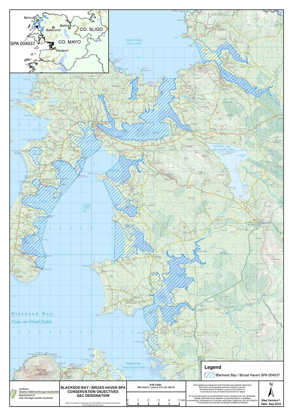
62 59
63 APPENDIX 2 Waterbird data sources Irish Wetland Bird Survey (I-WeBS) I-WeBS began in the Republic of Ireland in 1994/95 and aims to monitor wintering (non-breeding) waterbird populations at the wetland sites upon which they rely. Counts are carried out by volunteers and professional staff of the partner organisations across the months September to March of each year. I-WeBS counts take place on a rising tide or close to high tide. For further information please refer to Crowe (2005) and Boland & Crowe (2012). The I-WeBS Programme monitors the larger coastal wetland sites together with inland lakes, turloughs, rivers and callows. However the resulting dataset is incomplete for some waterbird species that utilise other habitats such as non-wetland habitat (e.g. grassland used by many species and particularly foraging geese, and swans), non-estuarine coastline, small and ephemeral wetlands and the open sea; the latter of which is obviously difficult to monitor from land-based surveys (Crowe, 2005). A number of additional and special surveys are therefore conducted on an annual or regular basis and data collected are, where appropriate, integrated into the I-WeBS database. These surveys include those undertaken for swan and geese species that forage typically during daylight hours across terrestrial habitats (e.g. grassland, arable fields) using coastal wetlands sites at night when they congregate to roost. Some of the additional surveys are carried out at certain times, aimed at providing a better estimate of numbers (e.g. Greylag Geese) and for some species an assessment of breeding success during the previous summer (e.g. Light-bellied Brent Geese). These surveys are introduced briefly below and more information is provided in Crowe (2005). Swan Surveys Coordinated international censuses are carried out of the wintering populations of Whooper Swan (Cygnus cygnus) and Bewick s Swan (Cygnus columbianus bewickii) at four or five-yearly intervals. The surveys are organised by I-WeBS, the Irish Whooper Swan Study group (IWSSG) and WWT. Greenland White-fronted Goose Greenland White-fronted Geese are concentrated at relatively few sites during winter, many of which are non-wetland habitats. The species is therefore not covered adequately by the I-WeBS programme. The Greenland White-fronted Goose census was initiated in the late 1970 s and is carried out by NPWS in Ireland and by JNCC and Scottish Natural Heritage (SNH) in Scotland. Greylag Geese Data for the Icelandic breeding population of Greylag Goose that winters in Ireland are taken from special surveys organised through I-WeBS and undertaken during November each year. The surveys aim to assess the distribution and status of the migratory flocks wintering in Ireland and focus on known feeding areas (grassland & agricultural land). When calculating population estimates of the Icelandic birds, data collected are adjusted to account for feral flocks that also occur within Ireland. Barnacle Goose (Branta leucopsis) A wintering population from the northeast Greenland breeding population winters mainly on offshore islands along the west coast of Ireland. An aerial survey is conducted of the principal wintering areas every four to five years. Light-bellied Brent Geese Special autumn surveys of this species have been conducted since 1996, organised in Ireland by the Irish Brent Goose Research Group (IBGRG). The survey is currently conducted on a bi-annual basis during the month of October which coincides with the autumn arrival of the species. Data collected are integrated into the I-WeBS database. 60
64 APPENDIX 3 Analysing population trends: a synopsis Monitoring of non-breeding waterbirds has been undertaken by the Irish Wetland Bird Survey (I-WeBS) and its partner, WeBS in Northern Ireland, since the mid 1990 s. For such long-term count data, there is clearly a need to assess long-term trends in a consistent and objective manner (Atkinson et al. 2006). - Jones, 1994) which models the raw monthly counts using a Generalised Linear Model (GLM). As part of this process, it accounts for changes in numbers at the site and the timing of the count (month, year) while also taking into account completed counts and trends at other sites. When counts at a site are flagged as poor quality (e.g. due to poor visibility) or where there are missing values in a given month, then the modelled values are used. This imputation process is used widely to replace missing data points (e.g. Houlahan et al. 2000; Atkinson et al. 2006; Leech et al. 2002; Gregory et al. 2005; Crowe et al. 2008). The resulting dataset is therefore complete for all months and seasons and comprises a combination of actual count data and imputed count data. This complete dataset is then modelled using a Generalised Additive Models (GAM) which fits a smoothed curve to the counts. GAMs are non-parametric and flexible extensions of the generalised linear model where the linear predictor of the GLM is replaced by a general additive predictor which allows mean abundance to vary as a smooth function of time. Count data are assumed to follow independent Poisson distribution with 0.3T degrees of freedom (e.g. after Atkinson et al. 2006). The application of GAM to analyse population trends was applied to UK farmland birds by Fewster et al. (2000) and has since been adopted for modelling waterbird trends elsewhere, for example, the UK WeBS Alert system (Leech et al. 2002). Smoothed count data for a site are then indexed to assess population trends over time. An index number can be defined as a measure of population size in one year expressed in relation to the size of the population in another selected year (Leech et al. 2002). Changes in the index numbers can -Jones, 1994). Annual indices are calculated separately for each species at a site. For each year included in an analysis, a total is obtained by summing the number of birds present in a predetermined number of months. The final year in the series of totals is then scaled to equal 100 (please see example in table). Index values in any given year therefore represent the number of individuals relative to those present in the final year. As this process is the same across all species and all sites analysed it allows for some useful comparisons. Count Data Index Un-smoothed indices are also calculated and provide a means of examining ( eye-balling ) the variation across time and can also be used to provide a measure of the mean annual change over the entire period. However, the GAM extension to the methodology and resultant smoothed indices allows for the calculation of proportional change in population size between one season and another. This latter calculation is used in Section 4.2 whereby trends are calculated for the long-term 14-year period (1995/ /10) and the recent five-year period (2004/ /10). The values given represent the percentage change in index (population) values across the specified time period, calculated by subtracting the smoothed index value at the start of the time-frame (1995) from the smoothed index value in the reference year (2009):- Change = ((I y I x) / I x ) x 100 where I y is the index from the current year and I x is the index value at the start of the selected time period (see example below) The reference year is the penultimate year in the time series because, when smoothing, the GAM takes into account values from both the preceding and following year. The last value in the smoothed dataset (2010) is therefore likely to be the least robust because it has no following year. The final result is therefore % change in population size across a specified time period. Larger values indicate larger proportional changes in population size; positive values indicating relative increases while negative values indicate relative decreases over the specified time period. 61
65 Worked example Year Unsmoothed Smoothed Term Change 5YR YR ALL YR Further information on population indexing and trend analysis can be found in various references; for particular reference to waterbirds see Leech et al (2002) and Atkinson et al. (2006). For information on the UK WeBS Alerts system, please see Thaxter et al. (2010) and Cook et al. (2013). Limitations The months chosen for the calculation of population indices aim to reflect the months when the populations at a site are the most stable, excluding months when there may be fluctuations due to passage populations. Despite this, some datasets still present a high degree of variability or fluctuation both within and between years. Because of this, we assess each species separately and take into account where a species shows a history of wide fluctuations between years (within national dataset), or where a species naturally exhibits within-season fluctuations (e.g. species considered to have weak site faithfulness). Where necessary the results of the trend analysis are assigned necessary caution. A high proportion of imputed counts can limit the effectiveness of the analysis to aid in the interpretation of the dataset. Species for which 50% or more of the monthly count values are imputed are excluded from analysis. But sometimes the calculation of population change may involve a comparison between winters where, at least one has a value based on a high proportion of imputed data. Where data for adjacent winters are relatively complete this is not a serious concern because of the smoothing technique used. However, where data for a number of consecutive winters rely heavily on imputed data then the resulting result is considered less reliable (Thaxter et al. 2010). Where necessary the results of the trend analysis are assigned necessary caution. Despite the smoothing effects of the GAM analysis, interpretation of population trends may sometimes still be difficult. Therefore we calculate proportional change in the population across differing time periods (e.g. 12-year, 10-year and 5-year periods) to assess more effectively how the population has fared over time. 62
66 APPENDIX 4 Waterbird species codes AE Arctic Tern Sterna paradisaea BY Barnacle Goose Branta leucopsis BA Bar-tailed Godwit Limosa lapponica BE Bean Goose Anser fabalis BS Bewick s Swan Cygnus columbianus AS Black Swan Cygnus atratus BH Black-headed Gull Chroicocephalus ridibundus BN Black-necked Grebe Podiceps nigricollis BW Black-tailed Godwit Limosa limosa BV Black-throated Diver Gavia arctica BG Brent Goose Branta bernicla CG Canada Goose Branta canadensis CM Common Gull Larus canus CS Common Sandpiper Actitis hypoleucos CX Common Scoter Melanitta nigra CN Common Tern Sterna hirundo CO Coot Fulica atra CA Cormorant Phalacrocorax carbo CU Curlew Numenius arquata CV Curlew Sandpiper Calidris ferruginea DN Dunlin Calidris alpina GA Gadwall Anas strepera GP Golden Plover Pluvialis apricaria GN Goldeneye Bucephala clangula GD Goosander Mergus merganser GB Great Black-backed Gull Larus marinus GG Great Crested Grebe Podiceps cristatus ND Great Northern Diver Gavia immer NW Greenland White-fronted Goose Anser albifrons flavirostris GK Greenshank Tringa nebularia H. Grey Heron Ardea cinerea GV Grey Plover Pluvialis squatarola GJ Greylag Goose Anser anser HG Herring Gull Larus argentatus JS Jack Snipe Lymnocryptes minimus KF Kingfisher Alcedo atthis KN Knot Calidris canutus L. Lapwing Vanellus vanellus 63
67 LB Lesser Black-backed Gull Larus fuscus PB Light-bellied Brent Goose Branta bernicla hrotra ET Little Egret Egretta garzetta LG Little Grebe Tachybaptus ruficollis AF Little Tern Sterna albifrons MA Mallard Anas platyrhynchos MU Mediterranean Gull Larus melanocephalus MH Moorhen Gallinula chloropus MS Mute Swan Cygnus olor OC Oystercatcher Haematopus ostralegus PG Pink-footed Goose Anser brachyrhynchus PT Pintail Anas acuta PO Pochard Aythya ferina PS Purple Sandpiper Calidris maritima RM Red-breasted Merganser Mergus serrator RH Red-throated Diver Gavia stellata RK Redshank Tringa totanus RP Ringed Plover Charadrius hiaticula RU Ruff Philomachus pugnax SS Sanderling Calidris alba TE Sandwich Tern Sterna sandvicensis SP Scaup Aythya marila SU Shelduck Tadorna tadorna SV Shoveler Anas clypeata SY Smew Mergus albellus SN Snipe Gallinago gallinago NB Spoonbill Platalea leucorodia DR Spotted Redshank Tringa erythropus T. Teal Anas crecca TU Tufted Duck Aythya fuligula TT Turnstone Arenaria interpres WA Water Rail Rallus aquaticus WM Whimbrel Numenius phaeopus WG White-fronted Goose Anser albifrons WS Whooper Swan Cygnus Cygnus WN Wigeon Anas penelope WK Woodcock Scolopax rusticola 64
68 APPENDIX 5 Waterbird foraging guilds (after Weller, 1999) Guild Foods Tactics Examples (1) Surface swimmer Invertebrates, vegetation & seeds Strain/sieve/sweep/dabble/gr ab/up-ending Dabbling ducks ; e.g. Shoveler, Teal, Mallard, Pintail, Wigeon, Gadwall (2) Water column diver shallow a Fish & Invertebrates; Search/grab Diving ducks e.g. Pochard, Tufted Duck, Scaup, Eider, (3) Water column diver greater depths (4) Intertidal walker, out of water (5) Intertidal walker, out of water (6) Intertidal walker, in water (7) Terrestrial, walker (e.g. grassland/marsh) a dives <3m. Fish & Invertebrates Search/grab Common Scoter, divers, grebes, Cormorant Invertebrates Search (probe)/grab Sandpipers, plovers Invertebrates, vegetation Sieve/grab/graze Fish Search/strike Grey Heron Shelduck, Avocet, Spoonbill, Wigeon, Light-Bellied Brent Goose, Fish, Invertebrates Probe, scythe, sweep/grab Spoonbill, Greenshank Fish Stalk Little Egret Invertebrates Probe Several sandpiper species Vegetation (inc. roots, Graze, peck, probe Many geese species tubers & seeds) Please note that this table refers to generalised foraging strategies and is meant as a guide only. There is a great deal of variation between sites, seasons, tidal states and indeed, individual birds themselves. For example, some waterbird species may deploy several of the methods, e.g. Shelduck may forage by sieving intertidal mud (5) or by up-ending (1) and Pintail, although generally known as a dabbling duck, does occasionally dive for food. 65
69 APPENDIX 6 Blacksod Bay/Broad Haven Waterbird survey programme 2009/10 Count Subsites Subsite Code Subsite name Area (ha) 0D055 Leam Lough 22 0D410 Tullaghaunnashammer: Blacksod 73 0D414 Feorinyeeo Bay: Blacksod 140 0D415 Blacksod Point 192 0D438 Broad Haven Bay 1,718 0D439 Blacksod Bay (sea) 6,782 0D459 Birranbaun: Blacksod 256 0D460 Trawnanaskil: Blacksod 125 0D468 Trawboy Cregganroe: Blacksod 250 0D469 Doona Strand: Blacksod 502 0D474 Trawkirtan: Broad Haven 204 0D475 Sruwaddacon Bay: Broad Haven 329 0D477 Seafield Bay: Blacksod 277 0D478 Saleen Harbour: Blacksod 257 0D479 Elly Bay: Blacksod 568 0D480 Aghleam Bay: Blacksod 330 0D489 Tullaghan Bay: Blacksod 612 0D490 Doolough Bay & Strand: Blacksod 730 0D491 Corraun Bay: Blacksod 100 0D493 Trawmore Bay: Blacksod 532 0D494 Claggan Strand: Blacksod 334 0D495 Blind Harbour 157 0D901 Kinfanalta Point: Blacksod
70 67
71 68
72 APPENDIX 7 Blacksod Bay/Broad Haven Waterbird distribution (dot-density diagrams) recorded during the low tide and high tide surveys (October 2009 February 2010) Shows birds distributed in subtidal and intertidal habitat only, plus those occurring in 0D055 (Leam Lough) 69
73 70
74 71
75 72
76 73
77 74
78 75
79 76
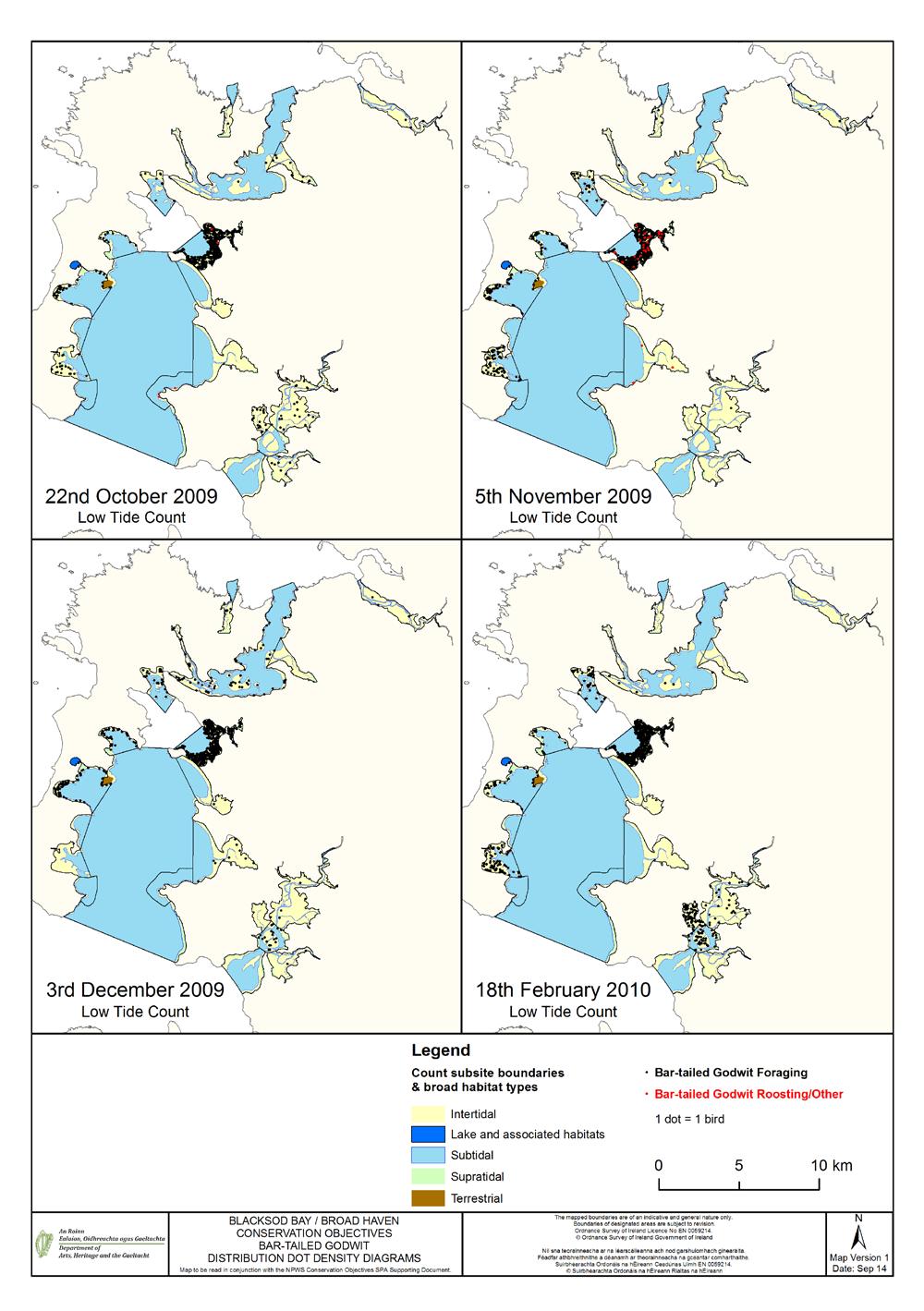
80 77
Malahide Estuary Special Protection Area. Conservation Objectives Supporting Document
 Malahide Estuary Special Protection Area (Site Code 4025) Conservation Objectives Supporting Document VERSION 1 National Parks & Wildlife Service August 2013 SUMMARY T A B L E O F C O N T E N T S PART
Castlemaine Harbour Special Protection Area. (Site Code 4029) Version 2. Conservation Objectives Supporting Document
 Version 2. Conservation Objectives Supporting Document") Castlemaine Harbour Special Protection Area (Site Code 4029) Version 2 Conservation Objectives Supporting Document National Parks & Wildlife Service March 2011 T A B L E O F C O N T E N T S PART ONE -
Castlemaine Harbour Special Protection Area (Site Code 4029) Version 2 Conservation Objectives Supporting Document National Parks & Wildlife Service March 2011 T A B L E O F C O N T E N T S PART ONE -
North Bull Island Special Protection Area (Site Code 4006) South Dublin Bay and River Tolka Estuary Special Protection Area (Site Code 4024)
 South Dublin Bay and River Tolka Estuary Special Protection Area (Site Code 4024)") North Bull Island Special Protection Area (Site Code 4006) & South Dublin Bay and River Tolka Estuary Special Protection Area (Site Code 4024) Conservation Objectives Supporting Document VERSION 1 National
North Bull Island Special Protection Area (Site Code 4006) & South Dublin Bay and River Tolka Estuary Special Protection Area (Site Code 4024) Conservation Objectives Supporting Document VERSION 1 National
Rogerstown Estuary Special Protection Area. Conservation Objectives Supporting Document
 Rogerstown Estuary Special Protection Area (Site Code 4015) Conservation Objectives Supporting Document VERSION 1 National Parks & Wildlife Service May 2013 T A B L E O F C O N T E N T S SUMMARY PART ONE
Baldoyle Bay Special Protection Area. Conservation Objectives Supporting Document
 Baldoyle Bay Special Protection Area (Site Code 4016) Conservation Objectives Supporting Document VERSION 1 National Parks & Wildlife Service December 2012 SUMMARY T A B L E O F C O N T E N T S PART ONE
Mid-Clare Coast Special Protection Area. Conservation Objectives Supporting Document
 Mid-Clare Coast Special Protection Area (Site Code 4182) Conservation Objectives Supporting Document VERSION 1 National Parks & Wildlife Service July 2014 SUMMARY T A B L E O F C O N T E N T S PART ONE
Tramore Back Strand Special Protection Area. Conservation Objectives Supporting Document
 Tramore Back Strand Special Protection Area (Site Code 4027) Conservation Objectives Supporting Document VERSION 1 National Parks & Wildlife Service September 2013 SUMMARY T A B L E O F C O N T E N T S
Donegal Bay Special Protection Area. Conservation Objectives Supporting Document
 Donegal Bay Special Protection Area (Site Code 4151) Conservation Objectives Supporting Document VERSION 1 National Parks & Wildlife Service January 2012 SUMMARY T A B L E O F C O N T E N T S PART ONE
Trawbreaga Bay Special Protection Area. Conservation Objectives Supporting Document
 Trawbreaga Bay Special Protection Area (Site Code 4034) Conservation Objectives Supporting Document VERSION 1 National Parks & Wildlife Service February 2014 TABLE OF CONTENTS SUMMARY PART ONE - INTRODUCTION...
Cabra, Dublin 7. Appropriate assessment (screening) Report prepared for Crekav Trading GP Limited. November 2017
 Report prepared for Crekav Trading GP Limited. November 2017") Proposed development at Former CIE Lands, Carnlough Road, Cabra, Dublin 7 Appropriate assessment (screening) Report prepared for Crekav Trading GP Limited November 2017 Roger Goodwillie & Associates, Lavistown
Proposed development at Former CIE Lands, Carnlough Road, Cabra, Dublin 7 Appropriate assessment (screening) Report prepared for Crekav Trading GP Limited November 2017 Roger Goodwillie & Associates, Lavistown
BROADMEADOW RIVER ESTUARY (SWORDS/MALAHIDE), CO. DUBLIN
, CO. DUBLIN") BROADMEADOW RIVER ESTUARY (SWORDS/MALAHIDE), CO. DUBLIN WATERBIRDS IN JULY AND AUGUST 2008 (with additional counts from 2004-2008) Oscar J. Merne, M.Sc. Ornithologist & Environmental Scientist August 2008
BROADMEADOW RIVER ESTUARY (SWORDS/MALAHIDE), CO. DUBLIN WATERBIRDS IN JULY AND AUGUST 2008 (with additional counts from 2004-2008) Oscar J. Merne, M.Sc. Ornithologist & Environmental Scientist August 2008
OFFICE OF ENVIRONMENTAL SUSTAINABILITY
 This report has been cleared for submission by David Flynn. Eve O'Sullivan, 13/03/2018 10:52 OFFICE OF ENVIRONMENTAL SUSTAINABILITY ENVIRONMENTAL LICENSING PROGRAMME TO: Eimear Cotter, Director FROM: Brian
The Effects on Waterbirds of Dredging at the Cardiff Bay Barrage Report for 2005/06
 The Effects on Waterbirds of Dredging at the Cardiff Bay Barrage Report for 2005/06 Authors N.H.K. Burton & S.J. Holloway Report of work carried out by The British Trust for Ornithology under contract
4.20 BLACKWATER ESTUARY
 4.20 BLACKWATER ESTUARY LTC site code: CB Centre grid: TL9507 JNCC estuarine review site: 112 Habitat zonation: 2368 ha intertidal, 1587 ha subtidal, 766 ha nontidal Statutory status: Blackwater Estuary
National Parks and Wildlife Service
 National Parks and Wildlife Service Conservation Objectives Series Wexford Harbour and Slobs SPA 004076 Page 1 of 39 National Parks and Wildlife Service, Department of Arts, Heritage and the Gaeltacht,
4.18 HAMFORD WATER. LTC site code:
 4.18 HAMFORD WATER LTC site code: BH Centre grid: TM2325 JNCC estuarine review site: 110 Habitat zonation: 367 ha intertidal, 106 ha subtidal, 58 ha nontidal Statutory status: Hamford Water SPA (UK9009131),
National Parks and Wildlife Service
 ISSN 2009-4086 National Parks and Wildlife Service Conservation Objectives Series South Dublin Bay and River Tolka Estuary SPA 004024 Page 1 of 23 National Parks and Wildlife Service, Department of Arts,
The Effect of the Cardiff Bay Barrage on Waterbird Populations Final Report
 The Effect of the Cardiff Bay Barrage on Waterbird Populations Final Report Authors N.H.K. Burton, M.M. Rehfisch & N.A. Clark Report of work carried out by The British Trust for Ornithology under contract
Report to Inform an Appropriate Assessment for the Firth of Forth SPA
 Report to Inform an Appropriate Assessment for the Firth of Forth SPA November 2009 No part of this report may be copied or reproduced by any means without prior written permission from Jacobs Arup - Jacobs
THE MERSEY GATEWAY PROJECT (MERSEY GATEWAY BRIDGE) AVIAN ECOLOGY SUMMARY PROOF OF EVIDENCE OF. Paul Oldfield
 AVIAN ECOLOGY SUMMARY PROOF OF EVIDENCE OF. Paul Oldfield") HBC/14/3S THE MERSEY GATEWAY PROJECT (MERSEY GATEWAY BRIDGE) AVIAN ECOLOGY SUMMARY PROOF OF EVIDENCE OF Paul Oldfield 1 1 DESCRIPTION OF THE BIRDLIFE IN THE UPPER MERSEY ESTUARY LOCAL WILDLIFE SITE 1.1
HBC/14/3S THE MERSEY GATEWAY PROJECT (MERSEY GATEWAY BRIDGE) AVIAN ECOLOGY SUMMARY PROOF OF EVIDENCE OF Paul Oldfield 1 1 DESCRIPTION OF THE BIRDLIFE IN THE UPPER MERSEY ESTUARY LOCAL WILDLIFE SITE 1.1
STOUR ESTUARY Essex, Suffolk
 STOUR ESTUARY Essex, Suffolk Internationally important: Nationally important: Pintail, Grey Plover, Knot, Dunlin, Black-tailed Godwit, Redshank Great Crested Grebe, Dark-bellied Brent Goose, Shelduck,
James Latham (Ecological Consultant)
") Identification of wintering waterbird high tide roosts on the Severn Estuary SSSI/SPA (Brean Down to Clevedon) Date: 10 th July 2015 This report has been prepared for: Natural England By: James Latham
Identification of wintering waterbird high tide roosts on the Severn Estuary SSSI/SPA (Brean Down to Clevedon) Date: 10 th July 2015 This report has been prepared for: Natural England By: James Latham
The Effect of the Cardiff Bay Barrage on Waterbird Populations 12. Distribution and Movement Studies August 2000-May 2001
 The Effect of the Cardiff Bay Barrage on Waterbird Populations 12. Distribution and Movement Studies August 2000-May 2001 Authors N.H.K. Burton, M.M. Rehfisch & N.A. Clark Report of work carried out by
Humber Management Scheme. Fact sheet: Wintering and passage birds
 Humber Management Scheme Fact sheet: Wintering and passage birds Introduction The Humber Estuary plays an international role in bird migration and is one of the most important wetland sites in the UK.
Summary of protection values of Finnish marine protection areas
 Appendix 5 Summary of protection values of Finnish marine protection areas s Table lists relevant Finnish Marine s in the vicinity of NSP2 project area and their conservation objectives. Sites are listed
Review and analysis of changes in waterbird use of the Mersey Estuary SPA, Mersey Narrows & North Wirral Foreshore pspa and Ribble & Alt Estuaries SPA
 Natural England Commissioned Report NECR173 Review and analysis of changes in waterbird use of the Mersey Estuary SPA, Mersey Narrows & North Wirral Foreshore pspa and Ribble & Alt Estuaries SPA First
PORTSMOUTH HARBOUR Hampshire
 PORTSMOUTH HARBOUR Hampshire Internationally important: Nationally important: None Dark-bellied Brent Goose, Red-breasted Merganser, Black-tailed Godwit Site description This large harbour in the Solent
LOUTH COUNTY COUNCIL. DRAFT LOCAL ECONOMIC & COMMUNITY PLAN Appropriate Assessment (AA) Screening Report DRAFT LECP
 Screening Report DRAFT LECP") LOUTH COUNTY COUNCIL DRAFT LOCAL ECONOMIC & COMMUNITY PLAN 2016-2022 Appropriate Assessment (AA) Screening Report A Plan for the promotion of economic and community development in County Louth TABLE OF
LOUTH COUNTY COUNCIL DRAFT LOCAL ECONOMIC & COMMUNITY PLAN 2016-2022 Appropriate Assessment (AA) Screening Report A Plan for the promotion of economic and community development in County Louth TABLE OF
ADDENDUM 1. The River Shannon & River Fergus Estuaries. Waterbird data and SIFP Areas Non-Technical Summary
 ADDENDUM 1 The River Shannon & River Fergus Estuaries Waterbird data and SIFP Areas Non-Technical Summary This addendum provides summary waterbird data for the SIFP areas. Please see Section 3.5 of the
JNCC estuarine review site: ha intertidal, 1024 ha subtidal, 541 ha nontidal
 4.56 DUDDON ESTUARY LTC site code: BD Centre grid: SD1977 JNCC estuarine review site: 39 Habitat zonation: 3589 ha intertidal, 1024 ha subtidal, 541 ha nontidal Statutory status: Duddon Estuary SPA (UK9005031),
APPENDIX 11O WINTERING SWAN AND GOOSE
 APPENDIX 11O WINTERING SWAN AND GOOSE Legislation The following legislation is the most relevant to whooper swan Cygnus cygnus and greylag geese Anser anser within the study area. The Conservation (Nature
BLACKWATER ESTUARY Essex
 BLACKWATER ESTUARY Essex Internationally important: Nationally important: Dark-bellied Brent Goose, Golden Plover, Grey Plover, Dunlin, Black-tailed Godwit, Redshank Cormorant, Shelduck, Wigeon, Teal,
Supplementary material
 Supplementary material Thomas Bregnballe, Ole Amstrup, Thomas E. Holm, Preben Clausen & Anthony D. Fox: Skjern River Valley, Northern Europe s most expensive wetland restoration project: benefits to breeding
Skogsøy Spring Migration. Preliminary Results. Julian Bell
 Skogsøy 26 Spring Migration Preliminary Results Julian Bell 26 1 1. Introduction...4 2. Species Accounts...5 Red-throated Diver Gavia stellata...6 Black-throated Diver Gavia arctica...7 Great Northern
Assessing ornithological impacts associated with wind farm developments: surveying recommendations
 Assessing ornithological impacts associated with wind farm developments: surveying recommendations This information note has been written to provide guidance to developers, Competent Authorities and others
Office of Climate, Licensing & Resource Use Environmental Protection Agency PO Box 3000 County Wexford 3 August 2010
 Kilcatherine, Eyeries, County Cork http://www.friendsoftheirishenvironment.org Office of Climate, Licensing & Resource Use Environmental Protection Agency PO Box 3000 County Wexford 3 August 2010 Westland
HELCOM workshop on migratory waterbirds
 HELCOM workshop on migratory waterbirds Helsinki, 20-22 November 2018 Aims: Produce maps with migration routes of waterbird species (e.g. seabirds, ducks, waders) covering the entire Baltic Sea Region.
WeBS Alerts 1998/99: Changes in numbers of wintering waterbirds in the United Kingdom at national, country and Special Protection Area (SPA) scales
 scales") WeBS s 1998/99: Changes in numbers of wintering waterbirds in the United Kingdom at national, country and Special Protection Area (SPA) scales Authors Philip W. Atkinson, Graham E. Austin, Niall H.K. Burton,
WeBS s 1998/99: Changes in numbers of wintering waterbirds in the United Kingdom at national, country and Special Protection Area (SPA) scales Authors Philip W. Atkinson, Graham E. Austin, Niall H.K. Burton,
Results of the third Non-Estuarine Waterbird Survey, including Population Estimates for Key Waterbird Species
 Results of the third Non-Estuarine Waterbird Survey, including Population Estimates for Key Waterbird Species Authors Graham Austin, Teresa Frost, Heidi Mellan, Dawn Balmer Report of work carried out by
Waterbird Disturbance Mitigation Toolkit Informing Estuarine Planning & Construction Projects
 Waterbird Disturbance Mitigation Toolkit Informing Estuarine Planning & Construction Projects Click on the Photograph to Enter Authors: N Cutts K Hemingway & J Spencer Version 3.2, March 2013 Copyright
STRATEGIC ENVIRONMENTAL ASSESSMENT SCREENING STATEMENT MAINTENANCE ACTIVITIES COASTAL PROTECTION SCHEMES OFFICE OF PUBLIC WORKS ENGINEERING SERVICES
 STRATEGIC ENVIRONMENTAL ASSESSMENT SCREENING STATEMENT MAINTENANCE ACTIVITIES OF COASTAL PROTECTION SCHEMES UNDER THE RESPONSIBILITY OF THE OFFICE OF PUBLIC WORKS ENGINEERING SERVICES OFFICE OF PUBLIC
Calidris alpina schinzii Britain & Ireland/SW Europe & NW Africa
 Period 2008-2012 European Environment Agency European Topic Centre on Biological Diversity Calidris alpina schinzii Britain & Ireland/SW Europe & NW Africa Annex I International action plan Yes No Dunlin,
Agreement on the Conservation of African-Eurasian Migratory Waterbirds (AEWA)
") Agreement on the Conservation of African-Eurasian Migratory Waterbirds (AEWA) A Tool for International Cooperation AEWA - An International Treaty Safeguarding Migratory Waterbirds The Agreement on the
Agreement on the Conservation of African-Eurasian Migratory Waterbirds (AEWA) A Tool for International Cooperation AEWA - An International Treaty Safeguarding Migratory Waterbirds The Agreement on the
Point Grey Tidal Marsh Project Standwatch Surveys February 20, 2014 to March 26, 2014
 Suite 250 1380 Burrard Street Vancouver, BC V6Z 2H3 T: 604.669.0424 F: 604.669.0430 hemmera.com Point Grey Tidal Marsh Project Standwatch Surveys February 20, 2014 to March 26, 2014 Report Date July 22,
Migratory Shorebird Conservation Action Plan
 Migratory Shorebird Conservation Action Plan The Migratory Shorebird Conservation Action Plan (MS CAP) has been developed by a broad range of stakeholders from all across the country and internationally
APPENDIX 11.2 BRENT GEESE SURVEY REPORT
 APPENDIX 11.2 BRENT GEESE SURVEY REPORT Light-bellied Brent Goose presence on Alfie Byrne Road Green Space and Belcamp Park in Dublin City along route corridor for proposed aviation fuel pipeline SUMMARY
Stour and Orwell Estuary European marine site
 Stour and Orwell Estuary European marine site English Nature s advice given under Regulation 33(2) of the Conservation (Natural Habitats &c.) Regulations 1994 English Nature s advice for Stour and Orwell
THE PROPOSED DUBLIN ARRAY WIND FARM ASSESSMENT OF POTENTIAL IMPACTS ON SEABIRDS
 THE PROPOSED DUBLIN ARRAY WIND FARM ASSESSMENT OF POTENTIAL IMPACTS ON SEABIRDS Information in support of the Appropriate Assessment of the proposed Wind Farm Report for: Prepared by: February 2013. THE
CORE MANAGEMENT PLAN INCLUDING CONSERVATION OBJECTIVES FOR
 CYNGOR CEFN GWLAD CYMRU COUNTRYSIDE COUNCIL FOR WALES CORE MANAGEMENT PLAN INCLUDING CONSERVATION OBJECTIVES FOR TRAETH LAFAN/LAVAN SANDS, CONWAY BAY SPA (incorporating a section of Y Fenai a Bae Conwy/Menai
SoN 2015: Landmark report shows European biodiversity going lost at unacceptable rates: intensive agriculture main culprit
 Brussels, 20 May 2015 SoN 2015: Landmark report shows European biodiversity going lost at unacceptable rates: intensive agriculture main culprit Landmark report shows European biodiversity going lost at
Analysis of sea-watching data from Holme Bird Observatory, Norfolk
 Analysis of sea-watching data from Holme Bird Observatory, Norfolk BTO Authors Aonghais S.C.P. Cook, Chris Thaxter, Lucy J. Wright, Nick J. Moran, Niall H.K. Burton, Jed Andrews, Sophie Barker and Fred
Dispersed Waterbirds Survey
 Dispersed Waterbirds Survey Title Dispersed Waterbird Survey 2002/03 Description and Summary of Results The main wetland sites are counted by the Wetland Bird Survey (WeBS) Core Counts -- monthly counts
North Solent Shoreline Management Plan. Appendix J: Appropriate Assessment
 North Solent Shoreline Management Plan Appendix J: Appropriate Assessment Contents Page No J1 INTRODUCTION...1 J1.1 Background...1 J1.2 Role of Organisations in the Appropriate Assessment Process...8
JNCC estuarine review site: ha intertidal, 608 ha subtidal, 27 ha nontidal Statutory status: Winter waterbird interest:
 4.50 CONWY ESTUARY LTC site code: EC Centre grid: SH7976 JNCC estuarine review site: 32 Habitat zonation: 1009 ha intertidal, 608 ha subtidal, 27 ha nontidal Statutory status: N/A Winter waterbird interest:
Table of Contents. 1 Introduction...3
 Cork County Council Proposed Amendment No2 to Midleton Local Area Plan (Carrigtwohill North Framework Masterplan) Habitats Directive Screening Statement Prepared by Cork County Council Planning Policy
WWT/JNCC/SNH Goose & Swan Monitoring Programme survey results 2005/06
 1. Abundance WWT/JNCC/SNH Goose & Swan Monitoring Programme survey results 2005/06 Whooper swan Cygnus cygnus The fifth international census of Whooper Swans wintering in Britain, Ireland and Iceland was
Calidris alpina schinzii Baltic/SW Europe & NW Africa
 Period 2008-2012 European Environment Agency European Topic Centre on Biological Diversity Calidris alpina schinzii Baltic/SW Europe & NW Africa Annex I International action plan Yes No Dunlin, Calidris
BP Conservation Programme. Final Report
 BP Conservation Programme Final Report Project title: Conserving the lakes of Son-Kol and Chatyr-Kol for waterbirds Location: Kyrgyz Republic Organisation: Karatal-Japyryk State Reserve Address: #3, 1-Maya
BirdLife International Marine Programme Marine Important Bird & Biodiversity Areas (Marine IBAs)
") Photo: Pep Arcos BirdLife International Marine Programme Marine Important Bird & Biodiversity Areas (Marine IBAs) Marguerite Tarzia- Marine Conservation Officer, BirdLife Europe marguerite.tarzia@birdlife.org
Photo: Pep Arcos BirdLife International Marine Programme Marine Important Bird & Biodiversity Areas (Marine IBAs) Marguerite Tarzia- Marine Conservation Officer, BirdLife Europe marguerite.tarzia@birdlife.org
DORNOCH FIRTH Highland
 DORNOCH FIRTH Highland Internationally important: Nationally important: Greylag Goose Whooper Swan, Wigeon, Teal, Bar-tailed Godwit Site description Dornoch Firth is a relatively narrow and steepsided
Assessment of Supporting Habitat (Docks) for Use by Qualifying Features of Natura 2000 Sites in the Liverpool City Region
 for Use by Qualifying Features of Natura 2000 Sites in the Liverpool City Region") Assessment of Supporting Habitat (Docks) for Use by Qualifying Features of Natura 000 Sites in the Liverpool City Region Ornithology Report Report Ref: 457.005 August 05 Assessment of Supporting Habitat
Assessment of Supporting Habitat (Docks) for Use by Qualifying Features of Natura 000 Sites in the Liverpool City Region Ornithology Report Report Ref: 457.005 August 05 Assessment of Supporting Habitat
Site Improvement Plan. Solway Firth SAC. Improvement Programme for England's Natura 2000 Sites (IPENS) Planning for the Future
 Planning for the Future") Improvement Programme for England's Natura 2000 Sites (IPENS) Planning for the Future Site Improvement Plan Solway Firth Site Improvement Plans (SIPs) have been developed for each Natura 2000 site in England
Improvement Programme for England's Natura 2000 Sites (IPENS) Planning for the Future Site Improvement Plan Solway Firth Site Improvement Plans (SIPs) have been developed for each Natura 2000 site in England
HABITATS REGULATIONS ASSESSMENT St. Anne s on the Sea Neighbourhood Plan Addendum to Screening Opinion OCTOBER 2016
 HABITATS REGULATIONS ASSESSMENT St. Anne s on the Sea Neighbourhood Plan Addendum to Screening Opinion OCTOBER 2016 CONTACTS JO WEAVER Senior Ecologist dd +44 (0)1453 423124 m +44 (0)7809 549186 e jo.weaver@arcadis.com
Branta leucopsis East Greenland/Scotland & Ireland
 Period 2008-2012 European Environment Agency European Topic Centre on Biological Diversity Branta leucopsis East Greenland/Scotland & Ireland Annex I International action plan Yes No Barnacle Goose, Branta
A Rising Tide: Conserving Shorebirds and Shorebird Habitat within the Columbia River Estuary
 A Rising Tide: Conserving Shorebirds and Shorebird Habitat within the Columbia River Estuary By Vanessa Loverti USFWS Migratory Birds and Habitat Programs, Portland, Oregon May 28, 2014 Outline of Talk
BC Coastal Waterbird Survey Protocol. Instructions for Participants
 Instructions for Participants Background The coastal marine habitat of British Columbia is home to many species of waterbirds and supports some of the highest densities of seabirds, waterfowl, and shorebirds
4.12 NORTH NORFOLK COAST
 4.12 NORTH NORFOLK COAST LTC site code: CN Centre grid: TF8946 JNCC estuarine review site: 102 Habitat zonation: 3447 ha intertidal, 2490 ha subtidal, 2701 ha nontidal Statutory status: North Norfolk Coast
WeBS Alerts 1999/2000: Changes in Numbers of Wintering Waterbirds in the United Kingdom at National, Country and SSSI Scales
 WeBS Alerts 1999/2000: Changes in Numbers of Wintering Waterbirds in the United Kingdom at National, Country and SSSI Scales Interim Report Authors Philip W. Atkinson, Mark M. Rehfisch & Mark Pollitt Data
State of nature in the EU: results from the reporting under the nature directives
 State of nature in the EU: results from the reporting under the nature directives 2007-2012 18 th Meeting Co-ordination Group for Biodiversity and Nature 12 March 2015 1 EEA technical report Contents Introduction
Screening Report for Appropriate Assessment of a proposed student residence development at University College Dublin, Dublin 4
 Screening Report for Appropriate Assessment of a proposed student residence development at University College Dublin, Dublin 4 1 Compiled by OPENFIELD Ecological Services Pádraic Fogarty, MSc MIEMA For
4.6 FIRTH OF FORTH. LTC site code:
 4.6 FIRTH OF FORTH LTC site code: BF Centre grid: NT0182 JNCC estuarine review site: 88 Habitat zonation: 5713 ha intertidal, 8032 ha subtidal, 64 ha nontidal Statutory status: Firth of Forth SPA (UK9004411),
Impact of wind farms on birds and bats
 Impact of wind farms on birds and bats Dr. Hermann Hötker Michael-Otto-Institut im NABU BirdLife Partner Germany Methods Disturbance and Displacement Collision mortality Repowering download: http://bergenhusen.nabu.de/bericht/voegelregenergien.pdf
Possible new marine Special Areas of Conservation and Special Protection Areas in Wales
 Possible new marine Special Areas of Conservation and Special Protection Areas in Wales Photo credit - PGH Evans / Seawatch Foundation // February 2015 www.naturalresourceswales.gov.uk This leaflet provides
2008 San Francisco Bay Shorebird Census
 2008 San Francisco Bay Shorebird Census San Francisco Bay is a great place for shorebirds! The salt ponds, tidal flats, marshes and seasonal wetlands provide important habitat for over a million resident
Sutton to Sandycove Cycleway & Footway. Interim Works Bull Wall (Wooden Bridge) To Causeway Road. Habitats Directive Assessment Screening Report
 To Causeway Road. Habitats Directive Assessment Screening Report") Sutton to Sandycove Cycleway & Footway Interim Works Bull Wall (Wooden Bridge) To Causeway Road Habitats Directive Assessment Screening Report FINAL ISSUE MARCH 2014 Client Civic Offices Wood Quay Dublin
Sutton to Sandycove Cycleway & Footway Interim Works Bull Wall (Wooden Bridge) To Causeway Road Habitats Directive Assessment Screening Report FINAL ISSUE MARCH 2014 Client Civic Offices Wood Quay Dublin
PREPARED FOR DUN LAOGHAIRE RATHDOWN COUNTY COUNCIL. Rev. Status Author Reviewed By Approved By Issue Date. REV01 Final KMOC PS PS 22/2/16
 PROVISION OF INFORMATION REGARDING APPROPRIATE ASSESSMENT SCREENING PROPOSED DEVELOPMENT, ASSISTANT HARBOUR MASTERS HOUSE 2 QUEENS ROAD, DÚN LAOGHAIRE, CO. DUBLIN PREPARED FOR DUN LAOGHAIRE RATHDOWN COUNTY
Site Improvement Plan. Ouse Washes SPA. Improvement Programme for England's Natura 2000 Sites (IPENS) Planning for the Future
 Planning for the Future") Improvement Programme for England's Natura 2000 Sites (IPENS) Planning for the Future Site Improvement Plan Ouse Washes Site Improvement Plans (SIPs) have been developed for each Natura 2000 site in England
Improvement Programme for England's Natura 2000 Sites (IPENS) Planning for the Future Site Improvement Plan Ouse Washes Site Improvement Plans (SIPs) have been developed for each Natura 2000 site in England
Dublin Port Masterplan 2040 Reviewed 2018 Natura Impact Statement. April
 Reviewed 2018 April 2018 www.dublinport.ie/masterplan Dublin Port Masterplan 2040 Reviewed 2018 Dublin Port Masterplan 2040 Reviewed 2018 DOCUMENT CONTROL SHEET Client Dublin Port Company Project Title
Scottish marine Special Protection Area network assessment
 Scottish marine Special Protection Area network assessment September 2018 Document version control Version Date Author Reason / Comments 1 12/04/2018 Emma Philip, Kate Thompson First draft 2 26/04/2018
Varangerbotn, Karlebotn and Meskelv are strategically situated innermost
 Varangerbotn Karlebotn Meskelv WWW.BIOFORSK.NO/FUGLETURISME Information sheet for the project «Bird tourism in central and eastern Finnmark», a project part of «The natural heritage as a value creator
Conserving the mangrove forests.
 Conserving the mangrove forests. The mangrove forests of Pretty Pool Creek and Four Mile Creek not only lend a unique beauty to the area, they also serve an important role in the environment s ecosystem.
Branta leucopsis Russia/Germany & Netherlands
 Period 2008-2012 European Environment Agency European Topic Centre on Biological Diversity Branta leucopsis Russia/Germany & Netherlands Annex I International action plan Yes No Barnacle Goose, Branta
LOCH LEVEN NATIONAL NATURE RESERVE (NNR) Proposed Local Access Guidance
 Proposed Local Access Guidance") LOCH LEVEN NATIONAL NATURE RESERVE (NNR) Proposed Local Access Guidance Summary This paper briefly outlines the rationale behind the proposed local access guidance for Loch Leven NNR. Introduction SNH
LOCH LEVEN NATIONAL NATURE RESERVE (NNR) Proposed Local Access Guidance Summary This paper briefly outlines the rationale behind the proposed local access guidance for Loch Leven NNR. Introduction SNH
General report format, ref. Article 12 of the Birds Directive, for the report
 Annex 1: General report format, ref. Article 12 of the Birds Directive, for the 2008-2012 report 0. Member State Select the 2 digit code for your country, according to list to be found in the reference
Bellanaboy Bridge Gas Terminal Licence Extension Application. For inspection purposes only.
 Bellanaboy Bridge Gas Terminal Industrial Emissions Licence Reg No P0738-01 Application for an extension to the period specified in Condition 1.5 NATURA IMPACT STATEMENT (NIS) An ecological impact assessment
STANDARD DATA FORM FOR SPECIAL PROTECTION AREAS (SPA) FOR SITES ELIGIBLE FOR IDENTIFICATION AS SITES OF COMMUNITY IMPORTANCE (SCI) AND
 FOR SITES ELIGIBLE FOR IDENTIFICATION AS SITES OF COMMUNITY IMPORTANCE (SCI) AND") Start Form NF004005 Site code: NATURA 2000 STANDARD DATA FORM FOR SPECIAL PROTECTION AREAS (SPA) FOR SITES ELIGIBLE FOR IDENTIFICATION AS SITES OF COMMUNITY IMPORTANCE (SCI) AND FOR SPECIAL AREAS OF CONSERVATION
Start Form NF004005 Site code: NATURA 2000 STANDARD DATA FORM FOR SPECIAL PROTECTION AREAS (SPA) FOR SITES ELIGIBLE FOR IDENTIFICATION AS SITES OF COMMUNITY IMPORTANCE (SCI) AND FOR SPECIAL AREAS OF CONSERVATION
MONITORING DIVERSITY AND ABUNDANCE OF WETLAND BIRDS. Chris Healey President, BirdLife East Gippsland
 MONITORING DIVERSITY AND ABUNDANCE OF WETLAND BIRDS Chris Healey President, BirdLife East Gippsland GIPPSLAND LAKES IMPORTANT BIRD AREA Ramsar site & Important Bird Area (GLIBA) Recognised under international
Local regional, national and international importance of the wader populations of the Dee Estuary and at Point of Ayr, Clwyd
 BTO Research Report No 88 Local regional, national and international importance of the wader populations of the Dee Estuary and at Point of Ayr, Clwyd A report by the British Trust for Ornithology to Nicholas
Key concepts of Article 7(4): Version 2008
: Version 2008") Species no. 44: Grey Plover Pluvialis squatarola Distribution: This plover has a circumpolar distribution, and inhabits tundra on arctic islands and the shores of the Arctic Ocean. Movements: Migratory.
Species no. 44: Grey Plover Pluvialis squatarola Distribution: This plover has a circumpolar distribution, and inhabits tundra on arctic islands and the shores of the Arctic Ocean. Movements: Migratory.
Mergellus albellus North-east Europe/Black Sea & East Mediterranean
 Period 2008-2012 European Environment Agency European Topic Centre on Biological Diversity Mergellus albellus North-east Europe/Black Sea & East Mediterranean Annex I International action plan Yes No Smew,
Anser fabalis fabalis North-east Europe/North-west Europe
 Period 2008-2012 European Environment Agency European Topic Centre on Biological Diversity Anser fabalis fabalis North-east Europe/North-west Europe Annex I International action plan No No Bean Goose,
Site Improvement Plan. Upper Nene Valley Gravel Pits SPA. Improvement Programme for England's Natura 2000 Sites (IPENS) Planning for the Future
 Planning for the Future") Improvement Programme for England's Natura 2000 Sites (IPENS) Planning for the Future Site Improvement Plan Upper Nene Valley Gravel Pits Site Improvement Plans (SIPs) have been developed for each Natura
Improvement Programme for England's Natura 2000 Sites (IPENS) Planning for the Future Site Improvement Plan Upper Nene Valley Gravel Pits Site Improvement Plans (SIPs) have been developed for each Natura
working today for nature tomorrow Low tide survey of The Wash Special Protection Area Final report of the winter shorebird survey
 Report Number 589 Low tide survey of The Wash Special Protection Area Final report of the winter 2002-2003 shorebird survey English Nature Research Reports working today for nature tomorrow English Nature
Low Tide Counts of Water Birds at Sabaki River Mouth Malindi, Kenya in
 Low Tide Counts of Water Birds at Sabaki River Mouth Malindi, Kenya in 4- A Conservation Research Project by A Rocha Kenya Simon Valle & Colin Jackson A Rocha Kenya, Watamu Ornithology Section, Zoology
is selected to co-ordinate the counts at the site level and to provide a single point of contact for the national organiser. At the end of a winter, c
 2 Methods SITE SELECTION The scope of the WeBS Low Tide Counts (LTCs) is estuarine sites throughout the United Kingdom. When the LTCs were originally planned, the aim was to systematically census each
Introducing an important new WSG publication on the status of migratory wader populations in Africa and western Eurasia in the 1990s
 Introducing an important new WSG publication on the status of migratory wader populations in Africa and western Eurasia in the 1990s DAVID STROUD & NICK DAVIDSON 2 Spring Meadows, Taylors Green, Warmington,
WATERBIRD MONITORING IN THE CONSERVATION ZONE OF THE CREERY WETLANDS. December 1998 to April 2004
 WATERBIRD MONITORING IN THE CONSERVATION ZONE OF THE CREERY WETLANDS December 1998 to April 2004 Prepared for: RPS Bowman Bishaw Gorham Pty Ltd, 290 Churchill Avenue, Subiaco, WA Prepared by: M.J. & A.R.
National Parks and Wildlife Service
 National Parks and Wildlife Service Conservation Objectives Lough Swilly SAC 002287 Lough Swilly SPA 004075 Page 1 of 41 Introduction The overall aim of the Habitats Directive is to maintain or restore
Wetland Bird Survey (Core Counts)
") Wetland Bird Survey (Core Counts) Title Wetland Bird Survey (WeBS) Core Counts 1954 to present Description and Summary of Results The UK is known to hold large numbers of waterbirds in the non-breeding
Wetland Bird Survey (Core Counts) Title Wetland Bird Survey (WeBS) Core Counts 1954 to present Description and Summary of Results The UK is known to hold large numbers of waterbirds in the non-breeding
Section 3: BIOLOGICAL ENVIRONMENT
 ABERDEEN HARBOUR EXPANSION PROJECT November 2015 Volume 2: Environmental Statement Section 3: BIOLOGICAL ENVIRONMENT ABERDEEN HARBOUR EXPANSION PROJECT November 2015 Volume 2: Environmental Statement