Baldoyle Bay Special Protection Area. Conservation Objectives Supporting Document
|
|
|
- August Boyd
- 6 years ago
- Views:
Transcription
1 Baldoyle Bay Special Protection Area (Site Code 4016) Conservation Objectives Supporting Document VERSION 1 National Parks & Wildlife Service December 2012
2 SUMMARY T A B L E O F C O N T E N T S PART ONE - INTRODUCTION Introduction to the designation of Special Protection Areas Introduction to Baldoyle Bay Special Protection Area Introduction to Conservation Objectives... 2 PART TWO SITE DESIGNATION INFORMATION Special Conservation Interests of Baldoyle Bay Special Protection Area... 4 PART THREE CONSERVATION OBJECTIVES FOR BALDOYLE BAY SPA Conservation Objectives for the non-breeding Special Conservation Interests of Baldoyle Bay SPA... 6 PART FOUR REVIEW OF THE CONSERVATION CONDITION OF WATERBIRD SPECIAL CONSERVATION INTERESTS Population data for waterbird SCI species of Baldoyle Bay SPA Waterbird population trends for Baldoyle Bay SPA Baldoyle Bay SPA site conservation condition of waterbird SCI species PART FIVE SUPPORTING INFORMATION Introduction Waterbird species Ecological characteristics, requirements and specialities summary information The 2011/12 waterbird survey programme Introduction Waterbird data, analyses and presentation Summary Results Waterbird distribution Baldoyle Bay - Activities and Events Introduction Assessment Methods Overview of activities at Baldoyle Bay Disturbance Assessment Discussion REFERENCES APPENDIX APPENDIX APPENDIX APPENDIX APPENDIX APPENDIX APPENDIX APPENDIX APPENDIX APPENDIX
3 SUMMARY This document presents conservation objectives for the non-breeding Special Conservation Interests of Baldoyle Bay Special Protection Area, designated under Directive 2009/147/EC on the conservation of wild birds (Birds Directive). Part One presents an introduction to the Special Protection Area (SPA) designation process and to the site designated as Baldoyle Bay Special Protection Area, as well as introducing the concept of conservation objectives and their formulation. Part Two provides site designation information for Baldoyle Bay SPA and Part Three presents the conservation objectives for this site. Part Four reviews the conservation condition of the site Special Conservation Interest (SCI) species based on an analysis of wintering (non-breeding) population trends. Importantly, this section states the current conservation condition of each of the SCI species and examines these site trends in light of all-ireland and international status and trends. Part Five provides supporting information that will assist the interpretation of the site-specific conservation objectives. This section includes a review of the ecological characteristics of the SCI species and examines waterbird distribution recorded during the 2011/12 Waterbird Survey Programme, drawing also on data from NPWS monitoring programmes (e.g. benthic surveys) and the Irish Wetland Bird Survey (I-WeBS). Part Five concludes with information on activities and events that occur in and around the site which may interact with waterbirds during the non-breeding season and includes an assessment of activities that were recorded to cause disturbance to non-breeding waterbirds during the 2011/12 Waterbird Survey Programme.
4 PART ONE - INTRODUCTION 1.1 Introduction to the designation of Special Protection Areas The over-arching framework for the conservation of wild birds within Ireland and across Europe is provided by Directive 2009/147/EC on the conservation of wild birds (the codified version of Council Directive 79/409/EEC as amended) (Birds Directive). Together with the EU Habitats Directive (Council Directive 92/43/EEC), these legislative measures provide for wild bird protection via a network of protected sites across Europe known as Natura 2000 sites, of which the overriding conservation objective is the maintenance (or restoration) of favourable conservation status of habitats and species. Under Article 4 of Directive 2009/147/EC, Ireland, along with other Member States, is required to classify the most suitable territories in number and size as Special Protection Areas (SPAs) for the conservation of certain wild bird species, which are: species listed in Annex I of the directive regularly occurring migratory species Also under Article 4, Member States are required to pay particular attention to the protection of wetlands, especially those of international importance. The National Parks & Wildlife Service (NPWS), part of the Department of the Arts, Heritage and the Gaeltacht, are responsible for the selection and designation of SPAs in Ireland. NPWS have developed a set of criteria, incorporating information relating to the selection of wetland sites developed under the Ramsar Convention, which are used to identify and designate SPAs. Sites that meet any of the following criteria may be selected as SPAs: A site regularly supporting 20,000 waterbirds or 10,000 pairs of seabirds; A site regularly supporting 1% or more of the all-ireland population of an Annex I species; A site regularly supporting 1% or more of the biogeographical population of a migratory species; A site that is one of the n most suitable sites in Ireland for an Annex I species or a migratory species (where n is a variable which is related to the proportion of the total biogeographic population of a species held by Ireland). The biogeographic population estimates and the recommended 1% thresholds for wildfowl and waders are taken from Wetlands International (Wetlands International, 2002); thresholds reflecting the baseline data period used. The all-ireland populations for the majority of wintering waterbirds are taken from Crowe et al. (2008). Site specific information relevant to the selection and designation of a SPA is collated from a range of sources including the Irish Wetland Bird Survey (I-WeBS), The Wetland Bird Survey (WeBS) in Northern Ireland, species specific reports and a wide range of scientific publications, reports and other surveys. If, following collation of all the available scientific data, a site meets the relevant criteria for designation and is selected as an SPA, a list of species for which the site is nationally important is compiled. These species are known as Special Conservation Interests and can be divided into two categories: Selection species: The species occurring at a site which identifies the site as qualifying for SPA status i.e. a species that met at least one of the following conditions: An Annex I species that occurs at the site in numbers that exceed the all-ireland 1% population threshold; 1
5 A migratory species that occurs at the site in numbers that exceed the biogeographic 1% population threshold; and/or A species for which the site is considered to be one of the n most suitable sites in Ireland for the conservation of that species (where n is a variable that is related to the proportion of the total biogeographic population held by Ireland). Additional Conservations Interests: Relevant Annex I or migratory species which exceed the all-ireland 1% threshold during the baseline period but were not selection species for the site. Wetlands and waterbirds: the wetlands of northwest Europe are a vital resource for millions of northern and boreal nesting waterbird species that overwinter on these wetlands or visit them when migrating further south. To acknowledge the importance of Ireland's wetlands to wintering waterbirds the term Wetland & Waterbirds can be included as a Special Conservation Interest for a Special Protection Area that has been designated for wintering waterbirds, and is or contains a wetland site of significant importance to one or more of the species of Special Conservation Interest. 1.2 Introduction to Baldoyle Bay Special Protection Area Baldoyle Bay is one of three estuaries on the north coast of Dublin, the other two being Rogerstown and Malahide Estuaries. Located 11km northeast of Dublin city centre, Baldoyle Bay is the most southerly of the three, and is situated just north of North Bull Island SPA, part of the Dublin Bay wetlands complex (NPWS, 2002). Baldoyle Bay is a relatively small, narrow estuary separated from the open sea by a large sand dune system. Two small rivers, the Sluice River and Mayne River, flow into the inner estuary. Portmarnock village sits at the estuary head while the mouth is marked by two points, Portmarnock Point on the northern side, and Cush Point on the southern side, with Baldoyle village located adjacent. The SPA extends eastwards approximately 500m past Cush Point (Appendix 1). At low tide, large areas of intertidal flats are exposed. These are mostly sands but grade to muds in the inner sheltered parts of the estuary. Extensive areas of Common Cord-grass (Spartina anglica) occur in the inner estuary. Both Narrow-leaved Eelgrass (Zostera angustifolia) and Dwarf Eelgrass (Z. noltii) occurred previously at the site but were not recorded in recent sampling programmes. Areas of saltmarsh occur near Portmarnock Bridge and at Portmarnock Point, with narrow strips found along other parts of the estuary. The Site Synopsis for Baldoyle Bay SPA and a map showing the SPA boundary are given in Appendix Introduction to Conservation Objectives The overriding objective of the Habitats Directive is to ensure that the habitats and species covered achieve favourable conservation status and that their long-term survival is secured across their entire natural range within the EU (EU Commission, 2010). In its broadest sense, favourable conservation status means that an ecological feature is being maintained in a satisfactory condition, and that this status is likely to continue into the future. Definitions as per the EU Habitats Directive are given in Box 1. 2
6 Box 1 Favourable Conservation Status as defined by Articles 1 (e) and 1(i) of the Habitats Directive The conservation status of a natural habitat is the sum of the influences acting on it and its typical species that may affect its long-term natural distribution, structure and functions as well as the long-term survival of its typical species. The conservation status of a natural habitat will be taken as favourable when: its natural range and areas it covers within that range are stable or increasing; and the specific structure and functions which are necessary for its long-term maintenance exist and are likely to continue to exist for the foreseeable future; and the conservation status of its typical species is favourable. The conservation status of a species is the sum of the influences acting on the species that may affect the long-term distribution and abundance of its populations. The conservation status will be taken as favourable when: the population dynamics data on the species concerned indicate that it is maintaining itself on a long-term basis as a viable component of its natural habitats; and the natural range of the species is neither being reduced nor is likely to be reduced for the foreseeable future; and there is, and will probably continue to be, a sufficiently large habitat to maintain its populations Site-specific conservation objectives define the desired condition or range of conditions that a habitat or species should be in, in order for these selected features within the site to be judged as favourable. At site level, this state is termed favourable conservation condition. Site conservation objectives also contribute to the achievement of the wider goal of biodiversity conservation at other geographic scales, and to the achievement of favourable conservation status at national level and across the Natura 2000 network 1. Where relevant, conservation objectives are defined for attributes 2 relating to non-breeding waterbird species populations, and for attributes related to the maintenance and protection of habitats that support them. These attributes are: Population trend; Population distribution; Habitat range and area (extent). Further guidance is given in Section 3.1 (Conservation Objectives for the Special Conservation Interests of Baldoyle Bay Special Protection Area). 1 Note that the terms conservation condition and conservation status are used to distinguish between site and the national level objectives respectively. 2 Attribute can be defined as: a characteristic of a habitat, biotope, community or population of a species which most economically provides an indication of the condition of the interest feature to which it applies (JNCC, 1998). 3
7 PART TWO SITE DESIGNATION INFORMATION 2.1 Special Conservation Interests of Baldoyle Bay Special Protection Area The Selection Species and Additional Special Conservation Interests 3 for Baldoyle Bay SPA are listed below and summarised in Table 2.1. This table also shows the importance of Baldoyle Bay SPA for its SCI species, relative to the importance of other sites within Ireland and within the Dublin region. The Selection Species listed for Baldoyle Bay SPA are as follows:- 1. During winter the site regularly supports 1% or more of the biogeographic population of Light-bellied Brent Geese (Branta bernicla hrota). The mean peak number of this species within the SPA during the baseline period (1995/ /00) was 726 individuals. 2. During winter the site regularly supports 1% or more of the all-ireland population of Ringed Plover (Charadrius hiaticula). The mean peak number of this species within the SPA during the baseline period (1995/ /00) was 223 individuals. 3. During winter the site regularly supports 1% or more of the all-ireland population of Bar-tailed Godwit (Limosa lapponica). The mean peak number of this Annex I species within the SPA during the baseline period (1995/ /00) was 353 individuals. Additional Special Conservation Interests for Baldoyle Bay SPA are as follows: 4. During winter the site regularly supports 1% or more of the all-ireland population of Shelduck (Tadorna tadorna). The mean peak number of this species within the SPA during the baseline period (1995/ /00) was 147 individuals. 5. During winter the site regularly supports 1% or more of the all-ireland population of Golden Plover (Pluvialis apricaria). The mean peak number of this Annex I species within the SPA during the baseline period (1995/ /00) was 2,120 individuals. 6. During winter the site regularly supports 1% or more of the all-ireland population of Grey Plover (Pluvialis squatarola). The mean peak number of this species within the SPA during the baseline period (1995/ /00) was 200 individuals. 7. The wetland habitats contained within Baldoyle Bay SPA are identified of conservation importance for non-breeding (wintering) migratory waterbirds. Therefore the wetland habitats are considered to be an additional Special Conservation Interest. 3 Note that Special Conservation Interest species are listed in the order of Selection Species followed by additional Special Conservation Interest species. Within these two categories, species are listed in taxonomic order. 4
8 Table 2.1 Site Designation Summary: species listed for Baldoyle Bay Special Protection Area, plus site importance at national, regional and county scale Special Conservation Interests Annex I species Baseline Population a Population status at baseline National Importance Rank 1 Regional Importance Rank 2 Selection Species Light-bellied Brent Goose (Branta bernicla hrota) Ringed Plover (Charadrius hiaticula) Bar-tailed Godwit (Limosa limosa) 726 Biogeographic importance All-Ireland importance 5 1 Yes 353 All-Ireland importance 17 3 Additional Special Conservation Interests Shelduck (Tadorna tadorna) Golden Plover (Pluvialis apricaria) Grey Plover (Pluvialis squatarola) Other conservation designations associated with the site b 147 All-Ireland importance 18 4 Yes 2,120 All-Ireland importance 25 1 SAC 200 All-Ireland importance 11 4 RAMSAR SITE IMPORTANT BIRD AREA (IBA) WILDFOWL SANCTUARY OTHER SAC Yes Yes No Statutory Nature Reserve a Baseline data are the 5-year mean peak counts for the period 1995/ /00 (I-WeBS) with the exception of Light-bellied Brent Goose (Robinson et al. 2004). b Note that other designations associated with Baldoyle Bay may relate to different areas and/or some of these areas may extend outside the SPA boundary. 1 National importance rank the number given relates to the importance of the site for the non-breeding population of a SCI species during the baseline period (1995/ /00) relative to other sites in Ireland. 2 Regional importance rank the number given relates to the importance of the site for the non-breeding population of a SCI species during the baseline period (1995/ /00) relative to other sites within the Dublin region. 5
9 PART THREE CONSERVATION OBJECTIVES FOR BALDOYLE BAY SPA 3.1 Conservation Objectives for the non-breeding Special Conservation Interests of Baldoyle Bay SPA The overarching Conservation Objective for Baldoyle Bay Special Protection Area is to ensure that waterbird populations and their wetland habitats are maintained at, or restored to, favourable conservation condition. This includes, as an integral part, the need to avoid deterioration of habitats and significant disturbance; thereby ensuring the persistence of site integrity. The site should contribute to the maintenance and improvement where necessary, of the overall favourable status of the national resource of waterbird species, and continuation of their long-term survival across their natural range. Conservation Objectives for Baldoyle Bay Special Protection Area, based on the principles of favourable conservation status, are described below and summarised in Table 3.1. Note that these objectives should be read and interpreted in the context of information and advice provided in additional sections of this report. Objective 1: To maintain the favourable conservation condition of the non-breeding waterbird Special Conservation Interest species listed for Baldoyle Bay SPA. This objective is defined by the following attributes and targets:- To be favourable, the long term population trend for each waterbird Special Conservation Interest species should be stable or increasing. 4 Waterbird populations are deemed to be unfavourable when they have declined by 25% or more, as assessed by the most recent population trend analysis. 5 To be favourable, there should be no significant decrease in the range, timing or intensity of use of areas by the waterbird species of Special Conservation Interest, other than that occurring from natural patterns of variation. 6 Factors that can adversely effect the achievement of Objective 1 include: Habitat modification: activities that modify discreet areas or the overall habitat(s) within the SPA in terms of how one or more of the listed species use the site (e.g. as a feeding resource) could result in the displacement of these species from areas within the SPA and/or a reduction in their numbers (for further discussion on this topic please refer to Section 5.4). Disturbance: anthropogenic disturbance that occurs in or near the site and is either singular or cumulative in nature could result in the displacement of one or more of the listed waterbird species from areas within the SPA, and/or a reduction in their numbers (for further discussion on this topic please refer to Section 5.4). 4 Note that population refers to site population (numbers wintering at the site) rather than the species biogeographic population. 5 Population trend analysis is presented in Section 4. 6 Waterbird distribution from the 2011/2012 waterbird survey programme is examined in Section 5. 6
10 Ex-situ factors: several of the listed waterbird species may at times use habitats situated within the immediate hinterland of the SPA or in areas outside of the SPA but ecologically connected to it. The reliance on these habitats will vary from species to species and from site to site. Significant habitat change or increased levels of disturbance within these areas could result in the displacement of one or more of the listed waterbird species from areas within the SPA, and/or a reduction in their numbers (for further information on this topic please refer to Section 5.2). Objective 2: To maintain the favourable conservation condition of the wetland habitat at Baldoyle Bay SPA as a resource for the regularly-occurring migratory waterbirds that utilise it. This objective is defined by the following attributes and targets:- To be favourable, the permanent area occupied by the wetland habitat should be stable and not significantly less than the area of 263 ha, other than that occurring from natural patterns of variation. The boundary of Baldoyle Bay SPA was defined to include the primary wetland habitats of this site. Objective 2 seeks to maintain the permanent extent of these wetland habitats, which constitute an important resource for regularly-occurring migratory waterbirds. The wetland habitats can be categorised into three broad types: subtidal; intertidal; and supratidal. Over time and though natural variation these subcomponents of the overall wetland complex may vary due to factors such as changing rates of sedimentation, erosion etc. Waterbird species may use more than one of the habitat types for different reasons (behaviours) throughout the tidal cycle. Subtidal areas refer to those areas contained within the SPA that lie below the mean low water mark and are predominantly covered by marine water. Tidal rivers, creeks and channels are included in this category. For Baldoyle Bay SPA this broad category is estimated to be 34 ha. Subtidal areas are continuously available for benthic and surface feeding ducks (e.g. Wigeon) and piscivorous/other waterbirds. Various waterbirds roost in subtidal areas. The relatively low proportion of subtidal habitat is due to the fact that this SPA is designated primarily for birds using intertidal habitats. The intertidal area is defined, in this context, as the area contained between the mean high water mark and the mean low water mark. For Baldoyle Bay SPA this is estimated to be 164 ha. When exposed or partially exposed by the tide, intertidal habitats provide important foraging areas for many species of waterbirds, especially wading birds, as well as providing roosting/loafing 7 areas. When the intertidal area is inundated by the tide it becomes available for benthic and surface feeding ducks and piscivorous/other waterbirds. During this tidal state this area can be used by various waterbirds as a loafing/roosting resource. The supratidal category refers to areas that are not frequently inundated by the tide (i.e. occurring above the mean high watermark) but contain shoreline and coastal habitats and can be regarded as an integral part of the shoreline. For Baldoyle Bay SPA this is estimated to be 65 ha. Supratidal areas are used by a range of waterbird species as a roosting resource as well as providing feeding opportunities for some species. The maintenance of the quality of wetland habitat lies outside the scope of Objective 2. However, for the species of Special Conservation Interest, the scope of Objective 1 covers the need to maintain, or improve where appropriate, the different properties of the wetland habitats contained within the SPA. 7 Loafing can be described as any behaviour not connected with breeding or feeding, and includes preening and resting. 7
11 Table 3.1 Conservation Objectives for the waterbird Special Conservation Interests of Baldoyle Bay SPA. Objective 1: To maintain the favourable conservation condition of the waterbird Special Conservation Interest species listed for Baldoyle Bay SPA, which is defined by the following list of attributes and targets: Parameter Attribute Measure Target Notes Population Population trend Percentage change as per population trend assessment using waterbird count data collected through the Irish Wetland Bird Survey and other surveys. Range Distribution Range, timing or intensity of use of areas used by waterbirds, as determined by regular low tide and other waterbird surveys. The long term population trend should be stable or increasing There should be no significant decrease in the range, timing or intensity of use of areas by the waterbird species of Special Conservation Interest other than that occurring from natural patterns of variation. Objective 2: Waterbird population trends are presented in Part Four of this document. Waterbird distribution from the 2011/12 waterbird survey programme is reviewed in Part Five of this document. To maintain the favourable conservation condition of the wetland habitat at Baldoyle Bay SPA as a resource for the regularly-occurring migratory waterbirds that utilise it. This is defined by the following attributes and targets: Parameter Attribute Measure Target Notes Area Wetland habitat Area (ha) The permanent area occupied by the wetland habitat should be stable and not significantly less than the area of 263 ha, other than that occurring from natural patterns of variation. The wetland habitat area was estimated as 263 ha using OSI data and relevant orthophotographs. 8
12 PART FOUR REVIEW OF THE CONSERVATION CONDITION OF WATERBIRD SPECIAL CONSERVATION INTERESTS 4.1 Population data for waterbird SCI species of Baldoyle Bay SPA Non-breeding waterbirds have been counted at Baldoyle Bay each winter as part of the Irish Wetland Bird Survey (I-WeBS) since the survey commenced in 1994/95. The site was counted once in 1994/95; otherwise the core survey months (September to March inclusive) were covered in all seasons. The core count period covers the main wintering period when many species occur in their largest concentrations, but also the autumn and spring passage periods when total waterbird numbers may be enhanced by staging/stopover birds 8. The site is counted as one single count unit. Note that the SPA area and the I-WeBS count area, although very similar, are not coincident. The SPA extends seawards in a southerly direction a little further than the I-WeBS count area; also a small area of amenity grassland at the head of the bay that is counted during I-WeBS is not included within the SPA. Table 4.1 presents population 9 data for non-breeding waterbirds of Baldoyle Bay. Annual maxima were identified and used to calculate the five-year mean peak for each species. The baseline period was 1995/ /00 while the recent average relates to the five-year period 2005/ /10. Baldoyle SPA is an important feeding and roosting resource for Light-bellied Brent Goose, a listed SCI species for the site. However, the same geese also utilise other locations that are outside of the SPA but may be inside or outside of the I-WeBS count boundary. These areas, which provide feeding resources for the geese, are largely amenity grasslands and/or agricultural fields. We therefore need to be cognisant of this association when assessing the size of the Brent Geese population of the SPA. To this end, population trend data presented below relate to data recorded from not only within the SPA but also from the immediate hinterland. When examining waterbird data, it is standard practice to use the mean of peak counts because they reflect more accurately the importance of a site for a particular species. Data are assessed within five-year periods to help account for inconsistencies in data gathering (i.e. differing coverage) or fluctuations in numbers. But it is important to note that waterbird counts represent a snapshot of bird numbers during a count session, so in general and taking into account all potential sources of error, resulting data are regarded to be underestimates of population size (Underhill & Prŷs-Jones, 1994). Table 4.1 highlights where the numbers shown surpass thresholds of International or all- Ireland importance. These thresholds are different for the baseline and recent time periods used; international thresholds are outlined in Wetlands International (2002) and Wetlands International (2006) for the baseline and recent site data respectively, while all-ireland thresholds are presented within Crowe et al. (2008). 8 The terms stopover and staging are often used interchangeably. A stopover site can be defined as any place where a bird takes a break during migration. Staging areas can be defined as stopover sites that attract large numbers of individuals and play an important part in re-fuelling the birds before their onward migration (e.g. Warnock, 2010). 9 Note that population refers to site population (numbers wintering at the site) rather than a species biogeographic population. 9
13 Table 4.1 Population data for non-breeding waterbird Special Conservation Interest Species of Baldoyle Bay SPA Site Special Conservation Baseline Period 1 Recent Site Data 2 Interests (SCIs) (1995/ /00) (2005/ /10) Light-bellied Brent Geese* 726 (i) 874 (i) Ringed Plover* 223 (n) 122 Bar-tailed Godwit* 353 (n) 134 Shelduck 147 (n) 290 (n) Golden Plover 2,120 (n) 914 Grey Plover 200 (n) 96 (n) * denotes site selection species. 1 Baseline data is the 5-year mean peak for the period 1995/ /00; 2 recent site data is the mean peak for the 5-year period 2005/ /10 (I-WeBS). (i) denotes numbers of international importance; (n) denotes numbers of all-ireland importance. 4.2 Waterbird population trends for Baldoyle Bay SPA The calculation and assessment of waterbird population trends at Irish coastal SPA sites follows the UK Wetland Bird Survey Alerts System which provides a standardised technique for monitoring changes in the numbers of non-breeding waterbirds over a range of spatial scales and time periods. The methods include the calculation of annual indices using a standard set of months which excludes passage periods (as opposed to the five year means calculated in Section 4.1 above) so it should be borne in mind that waterbird population data presented in Section 4.1 and 4.2 are not directly comparable. A detailed methodology for the trend analysis is provided in Appendix 3. Annual population indices were calculated for waterbird SCI species for the data period 1994/95 to 2008/09. Trends are given for the long-term 12-year period (1995/ /08) and the recent ( short-term ) five-year period (2002/ /08) (Table 4.2). The values given represent the percentage change in index (population) values across the specified time period. Positive values equate to increases in population size while negative values reflect a decrease in population size. Waterbirds are relatively long-lived birds and changes in population size can take several years to become evident. The short-term trend can be useful to assess whether species numbers at the site are remaining stable, showing increase or signs of recovery, or are continuing to decline. For example, although a species long-term trend may be negative, the short-term trend could be positive if numbers have increased during the recent five year period being assessed. Importantly, the short-term trend may detect more rapidly where a species population is beginning to decline. Table 4.2 Site Population Trends for waterbird Special Conservation Interest species of Baldoyle Bay SPA Site Special Conservation Site Population Trend 1 Site Population Trend 2 Interests (SCIs) 12 Yr 5 Yr Light-bellied Brent Geese* Ringed Plover* Bar-tailed Godwit* Shelduck Golden Plover Grey Plover * denotes site selection species; 1 Site population trend analysis: 12 yr = 1995/ /08; 2 Site population trend analysis: 5 yr = 2002/ /08. For selected species, explanatory notes are given below to aid the interpretation of trends. Graph headings use waterbird species codes and a list of these is provided in Appendix 4. 10
14 Light-bellied Brent Goose this species has shown a trend for progressive increase at Baldoyle Bay throughout I-WeBS. This is consistent with the all- Ireland and national trends (Crowe et al. 2008; Boland & Crowe, ) PB Unsmoothed Smoothed Ringed Plover numbers have fluctuated throughout I-WeBS with numbers highest during the late 1990 s/early 2000 s and once again approaching these levels in 2008/ RP Unsmoothed Smoothed BA Bar-tailed Godwit this species underwent a period of increasing numbers (1995/ /01) followed by subsequent decrease in numbers (2001/ /07). Numbers since 2005/06 have been stable but much lower than at any other time during I-WeBS Unsmoothed Smoothed Golden Plover while the raw indices have fluctuated, the smoothed line highlights the underlying trend for gradual decrease in numbers, especially during the earlier seasons of I-WeBS. In more recent years numbers have been largely stable and this pattern is relatively consistent with that observed nationally (Boland & Crowe, 2012) GP Unsmoothed Smoothed National trends presented in Boland & Crowe (2012) update those previously shown in Crowe (2005). 11
15 Grey Plover numbers fluctuated widely especially during the early seasons of I-WeBS. The species has a declining trend nationally (Boland & Crowe, 2012) with a similar decline observed in Britain and Northern Ireland (Calbrade et al. 2010) GV Unsmoothed Smoothed Baldoyle Bay SPA site conservation condition of waterbird SCI species Conservation condition of waterbird species is determined using the long-term site population trend and is assigned using the following criteria: Favourable population = population is stable/increasing. Intermediate (unfavourable) = Population decline in the range %. Unfavourable population = populations that have declined between % from the baseline reference value. Highly Unfavourable population = populations that have declined > 50.0% from the baseline reference value. The threshold levels of >25.0% and >50.0% follows standard convention used for waterbirds (e.g. Lynas et al. 2007; Leech et al. 2002). The Intermediate range (1.0% % decline) allows for natural fluctuations and represents a range within which relatively small population declines have the potential to be reversible and less likely to influence conservation status in the long-term (Leech et al. 2002). Declines of more than 25.0% are deemed of greater ecological significance for the long-term. With regards the six waterbird species of Special Conservation Interest listed for Baldoyle Bay SPA, and based on the long-term population trend for the site, it has been determined that (Table 4.3): species is currently considered as Highly Unfavourable (Bar-tailed Godwit); 2. 2 species are currently considered as Unfavourable (Golden Plover & Grey Plover); 3. 1 species is currently considered as Intermediate Unfavourable (Ringed Plover); 4. 2 species are currently considered as Favourable (Light-bellied Brent Geese & Shelduck). 12
16 Site conservation condition and population trends were also reviewed in light of species all- Ireland and international trends (Table 4.3). The calculation of all-ireland trends (island of Ireland) for the long-term (12-year) data period was facilitated by the provision of indices from the I-WeBS and the WeBS database 11 ; International trends follow Wetlands International (2006). Table 4.3 SCI species of Baldoyle Bay SPA Current Site Conservation Condition Special BoCCI Site Population Site Current all- Current Conservation Category a Trend b Conservation Ireland International Interests Condition Trend c Trend d Light-bellied Brent Amber Favourable + 58 Increase Geese* Ringed Plover* Amber Intermediate Decline (Unfavourable) Bar-tailed Godwit* Amber Highly Stable Unfavourable Shelduck Amber Favourable Stable Golden Plover Red Unfavourable Decline Grey Plover Amber Unfavourable Decline * denotes site selection species. a After Lynas et al. (2007); b Site population trend analysis; see Table 4.2; c all-ireland trend calculated for period 1994/95 to 2008/09; d international trend after Wetland International (2006). Table 4.3 also shows the relationship between a species long-term site trend and the current all-ireland trend for the same time period (1994/95 to 2008/09). The colour coding used represents the following cases:- Green species whose populations are stable or increasing at both site level and all-ireland level. Beige species whose populations are declining at both site level and all-ireland level. Therefore there is a potential for factors at a larger spatial scale to be influencing the observed trend at site level. Orange - species whose populations are exhibiting a % decline at site level but are stable or increasing at all-ireland level. Pink - species whose populations are exhibiting a % decline at site level but are stable or increasing at all-ireland level. Red - species whose populations are exhibiting a decline of >50.0% at site level but are stable or increasing at all-ireland level. The pink and red categories highlight where populations are stable at all-ireland level, but where significant declines are seen at site level. In these cases it would be reasonable to suggest that site-based management issues may be responsible for the observed declining site population trends (Leech et al. 2002). 11 kindly provided by the I-WeBS Office and the British Trust for Ornithology. 13
17 PART FIVE SUPPORTING INFORMATION 5.1 Introduction Part Five of this report is based around the need to review, collate and disseminate sitespecific information relating to the Special Conservation Interests of Baldoyle Bay SPA. Section 5.2 provides selected ecological summary information for non-breeding waterbirds of Baldoyle Bay. Section 5.3 presents results from the 2011/12 Waterbird Survey Programme. Finally, Section 5.4 provides summary information on activities and events that occur in and around Baldoyle Bay that may either act upon the habitats within the site, or may interact with waterbirds using the site. The information provided is intended to:- assist the interpretation and understanding of the site-specific conservation objectives; facilitate the identification of conservation priorities and direct site management measures; inform the scope and nature of Appropriate Assessments in applying the provisions of Article 6 of the Habitats Directive. Note however, that the information does not aim to provide a comprehensive assessment on which to assess plans and projects as required under the Habitats Directive, but rather should inform the scope of these assessments and help direct where further detailed examinations are required. The information presented in this report was compiled in July Waterbird species Ecological characteristics, requirements and specialities summary information Waterbirds, defined as birds that are ecologically dependent on wetlands (Ramsar Convention, 1971), are a diverse group that includes divers, grebes, swans, geese and ducks, gulls, terns and wading birds. During the data period 1994/ /10 the I-WeBS database shows a total of 56 waterbird species that have been recorded within Baldoyle Bay. These species represent eleven waterbird families: Gaviidae (divers), Podicipedidae (grebes), Anatidae (swans, geese and ducks), Rallidae (Water Rail, Moorhen & Coot), Haematopodidae (oystercatchers), Charadriidae (plovers and lapwings), Scolopacidae (sandpipers and allies) and Laridae (gulls and terns) plus Phalacrocoracidae (Cormorants), Ciconiiformes (Herons) and Alcedinidae (Kingfisher). As described in Section 1.1, the wetland habitats contained within this SPA are considered to be a Special Conservation Interest in their own right. The wetland habitat is an important resource for listed SCI species and for other waterbird species included in the total waterbird assemblage. These species may include those that utilise the site during passage, those that are present in months of the year outside of the non-breeding season 12 or species that use the site at certain times only (e.g. as a cold weather refuge). 29 waterbird species occurred on a regular basis within Baldoyle Bay during the I-WeBS period 1994/ / Six of these species are listed as SCIs for the SPA, and the additional 23 non-sci species are listed in Table Non-breeding season is defined as September March inclusive. 13 Regular is defined as a species that has occurred in 12 out of the 16-year data period. 14
18 Table 5.1 Regularly-occurring non SCI waterbird species that occur at Baldoyle Bay during the non-breeding season Species Baseline Data Period 1 Recent Site Average 2 (1995/ /00) (2005/ /10) Wigeon (Anas penelope) Teal (Anas crecca) Mallard (Anas platyrhynchos) Pintail (Anas acuta) 35 (n) 26 (n) Common Scoter (Melanitta nigra) Red-breasted Merganser (Mergus serrator) Red-throated Diver (Gavia stellata) 6 4 Great Northern Diver (Gavia immer) 3 2 Great Crested Grebe (Podiceps cristatus) Cormorant (Phalacrocorax carbo) Grey Heron (Ardea cinerea) Oystercatcher (Haematopus ostralegus) (n) Lapwing (Vanellus vanellus) Knot (Calidris canutus) Sanderling (Calidris alba) Dunlin (Calidris alpina) Snipe (Gallinago gallinago) 10 5 Black-tailed Godwit (Limosa limosa) (n) Curlew (Numenius arquata) Greenshank (Tringa nebularia) (n) Redshank (Tringa totanus) (n) Turnstone (Arenaria interpres) Kingfisher (Alcedo atthis) 1 1 Grey shading denotes an Annex I species; 1 Baseline data is the 5-year mean peak for the period 1995/ /00 (I-WeBS); 2 recent site data is the 5-year mean peak for the 5-year period 2005/ /10 (I-WeBS). Although waterbirds may be linked by their dependence on water, different species vary considerably in aspects of their ecology due to many evolutionary adaptations and specialisations to their wetland habitats. Different species or groups of species may therefore utilise wetland habitats in very different ways which relates to how species are distributed across a site as a whole. Table 5.2 provides selected ecological information for waterbird SCI species of Baldoyle Bay SPA. Information is provided for the following categories 14 :- waterbird family (group); winter distribution species distribution range during winter (based on the period 2001/ /09 (after Boland & Crowe, 2012); trophic (foraging) guild (after Weller, 1999; see Appendix 5); food/prey requirements; principal supporting habitat within the site; ability to utilise other/alternative habitat in/around the site; site fidelity (species faithfulness to wintering sites). It should be borne in mind that a single wetland site is unlikely to meet all of the ecological requirements of a diverse assemblage of waterbirds (Ma et al. 2010). Although some waterbird species will be faithful to specific habitats within the SPA, many will at times also use habitats situated within the immediate hinterland of the site or in areas ecologically connected to the SPA. These areas may be used as alternative high tide roosts, as a foraging resource or, be simply flown over, either on migration or on a more frequent basis throughout the non-breeding season as waterbirds move between different areas used (e.g. commuting corridors between feeding and roosting areas). 14 Notes to aid the understanding of categories and codes used in Table 5.2 are provided in the table sub text. 15
19 Reliance on alternative habitats will vary between species and from site to site. Use of alternative habitats is also likely to vary through time, from seasonally through to daily, and different habitats may be used by day and night (Shepherd et al. 2003). Different waterbirds may utilise wetland habitats in different ways. For example, while the majority of wading birds forage across exposed tidal flats, species such as Lapwing and Golden Plover are considered to be terrestrial waders, typically foraging across grassland and using tidal flats primarily for roosting. When tidal flats are covered at high water, intertidally-foraging waterbirds are excluded and many will move to nearby fields to feed. Terrestrial foraging is also important when environmental factors (e.g. low temperature) reduce the profitability of intertidal foraging (e.g. Zwarts & Wanink, 1993). Some waterbird species are simply generalists, and make use of a range of habitats, for example the Black-tailed Godwit that forages across intertidal mudflats and grassland habitats. Other waterbird species such as Greenland White-fronted Goose (Anser albifrons flavirostris) or Bewick s Swan (Cygnus columbianus bewickii) are herbivores and are therefore reliant on terrestrial areas, often outside of the SPA boundary, and use the wetland site primarily for roosting. Some species switch their habitat preference as food supplies become depleted; an example being Light-bellied Brent Geese that exploit grasslands increasingly when intertidal seagrass and algae become depleted. The topic of alternative habitat use is also applicable to benthic-foraging seaducks and divers whose foraging distribution is highly influenced by water depth and tidal conditions. Many of these species however (e.g. Great Northern Diver, Common Scoter) exhibit a widespread coastal distribution during winter utilising shallow nearshore waters to a greater degree at certain times (e.g. storms, driving onshore winds). Thus the area designated as an SPA can represent a variable portion of the overall range of the listed waterbird species. To this end, data on waterbird use of areas adjacent to or ecologically connected to the SPA are often collected. Indeed for some species a mix of siterelated and wider countryside measures are needed to ensure their effective conservation management (Kushlan, 2006). Furthermore, it is recommended that assessments that are examining factors that have the potential to affect the achievement of the site s conservation objectives should also consider the use of these ex-situ habitats, and their significance to the listed bird species. 16
20 Table 5.2 Waterbirds Ecological characteristics, requirements & specialities Family (group) Winter distribution A Trophic Guild B Food/Prey Requirements C Principal supporting habitat within site D Ability to utilise other/alternative habitats E Site Fidelity F SELECTION SPECIES Light-bellied Brent Goose Anatidae Localised 1, 5 Highly specialised Intertidal mud and sand flats 2 High Branta bernicla hrota (geese) Ringed Plover Charadriidae (wading Localised 4 Wide Intertidal mud and sand flats 3 High Charadrius hiaticula birds) Bar-tailed Godwit Limosa lapponica Scolopacidae (wading birds) Localised 4 Wide Intertidal mud and sand flats 3 Moderate ADDITIONAL SPECIAL CONSERVATION INTERESTS Shelduck Anatidae (shelducks) Localised 1, 5 Wide Intertidal mud and sand flats 3 High Tadorna tadorna Golden Plover Charadriidae (wading Intermediate 4 Wide Intertidal mud and sand flats 2 Moderate Pluvialis apricaria birds) Grey Plover Pluvialis squatarola Charadriidae (wading birds) Localised 4 Wide Intertidal mud and sand flats 3 High A Winter distribution: Very widespread (>300 sites); Widespread ( sites); Intermediate ( sites); Localised ( sites); Highly restricted (<50 sites) (based on Boland & Crowe, 2012). B Waterbird foraging guilds. 1 = Surface swimmer, 2 = water column diver (shallow), 3 = water column diver (deeper), 4/5 = intertidal walker (out of water), 6 = intertidal walker (in water), 7 = terrestrial walker. Further details are given within Appendix 5. C Food/prey requirements - species with a wide prey/food range; species with a narrower prey range (e.g. species that forage upon a few species/taxa only), and species with highly specialised foraging requirements (e.g. piscivores). D Principal supporting habitat present within Baldoyle Bay. Note that this is the main habitat used when foraging with the exception of Golden Plover which relates primarily to roosting habitat. E Ability to utilise alternative habitats refers to the species ability to utilise other habitats adjacent to the site. 1 = wide-ranging species with requirement to utilise the site as and when required; 2 = reliant on site but highly likely to utilise alternative habitats at certain times (e.g. high tide); 3 = considered totally reliant on wetland habitats due to unsuitable surrounding habitats and/or species limited habitat requirements. F Site fidelity on non-breeding grounds: Unknown; Weak; Moderate; or High (based on published literature). 17
21 5.3 The 2011/12 waterbird survey programme Introduction The 2011/12 waterbird survey programme was designed to investigate how waterbirds are distributed across coastal wetland sites during the low tide period. The surveys ran alongside and are complementary to the Irish Wetland Bird Survey (I-WeBS) which is a nationwide survey undertaken primarily on a rising tide or at high tide. At Baldoyle Bay SPA, a standard survey programme of four low tide counts (October, November & December 2011 and February 2012) and a high tide count (January 2012) were completed across the site. 15 Waterbirds were counted within a series of 14 count subsites (see map in Appendix 6) that covered the area designated as Baldoyle Bay SPA plus additional areas outside of the SPA boundary. These additional areas included intertidal areas west of Howth, Velvet Strand, and three inland areas of grassland (parks) that are known to be used by foraging Light-bellied Brent Geese during winter months. The behaviour of waterbirds during counts was attributed to one of two categories (foraging or roosting/other) while the position of birds was recorded in relation to one of four broad habitat types (Table 5.3). Note that these broad habitats were defined specifically for the survey programme and do not follow strict habitat-based definitions for these areas, nor follow definitions used in relation to conservation objectives outlined in Section 3.1. For a detailed survey methodology, please refer to NPWS (2011a). Table 5.3 Definition of broad habitat types used Broad Habitat Type Intertidal (area between mean high water and mean low water) Subtidal (area that lies below mean low water) Supratidal Terrestrial Broad Habitat Description Refers to the area uncovered by the tide and most likely dominated by mudflats and sandflats. It may also include areas of rocky shoreline, areas of mixed sediment and grave/pebbles or shingle and gravel shores. Refers to areas that are covered by seawater during counts. During low-tide counts it will include offshore water, tidal channels and creeks as well as tidal rivers. This category pertains to the shore area and habitats immediately marginal to and above the mean high-water mark. The supratidal section is an integral part of the shoreline. This broad habitat also includes areas of saltmarsh where the saltmarsh is contiguous with coastal habitats lying above. Note that patches of lower saltmarsh (e.g. Spartina sp.) surrounded by intertidal flats, were included in the intertidal category. Used where birds were recorded within habitats close to the shoreline but were above the intertidal and supratidal levels. In addition to the main survey programme described above, two high tide roost surveys were completed on 25 th November 2011 and 21 st February These dates were chosen to reflect roosting distribution during a spring tide and neap tide respectively. During these surveys waterbird roost sites were located, species and numbers of waterbirds counted and the position of roosts marked onto field maps Waterbird data, analyses and presentation The aim of data analyses was to understand how waterbirds are distributed across the site of Baldoyle Bay during the autumn and winter months. By assessing patterns of waterbird distribution at low and high tide, together with examination of data on sediment and invertebrate distribution and abundance, we aimed to identify areas (subsites) within the site that are the most important for foraging and roosting on a species by species basis. 15 Low tide surveys: 05/10/11, 04/11/11, 05/12/11 & 02/02/12 plus a high tide survey on 10/01/12. 18
22 Data analyses were undertaken to determine the proportional use of subsites by each Special Conservation Interest (SCI) species, relative to the whole area surveyed on each survey occasion. Analyses were undertaken on datasets as follows: Total numbers (low tide surveys); Total numbers (high tide survey); Total numbers of foraging birds (low tide surveys); Total numbers of roosting birds (low tide and high tide surveys). For each of the analyses listed above and for each survey date completed, subsites were ranked in succession from the highest to the lowest in terms of their relative contribution to each species distribution across all subsites surveyed. Rank positions were then converted to categories (see below) with the exception of those relating to the single high tide survey that are presented simply as rank numbers. The highest rank position/category for each subsite across any of the low tide count dates is presented in a subsite by species matrix. Subsite Rank Position - Categories Very High (V) Any section ranked as 1. High (H) Top third of ranking placings (where n = total number of count sections species was observed in) Moderate (M) Mid third of ranking placings (where n = total number of count sections species was observed in) Low (L) Lower third of ranking placings (where n = total number of count sections species was observed in). Intertidal foraging density was calculated for selected species and for each low tide survey occasion, by dividing the number of the species within a subsite by the area of intertidal habitat within the same subsite. Subsites were ranked based on the peak foraging density recorded. Whole site intertidal foraging density was calculated by summing the mean subsite counts for each species and dividing by the total area of intertidal habitat. Waterbird count data for low tide surveys are also presented as species distribution maps ( dot density maps ). Dot-density maps show waterbird species distribution within intertidal, subtidal and terrestrial habitat 16 divided into foraging birds and roosting/other birds. These maps show the number of birds represented by dots; each dot representing one, or a predetermined number of birds. As the dots are placed in the appropriate subsites and broad habitat types for the birds counted, the resulting map is equivalent to presenting numbers and densities and provides a relatively quick way of assessing species distribution. In contrast to dot-density maps, roost maps produced from roost survey data show the mapped locations of waterbird roosts, but note the limitations in relation to field mapping discussed below. Notes on data interpretation and methodological limitations Subsite rankings and dot-density maps relate to the distribution of waterbirds at subsite level as recorded within the survey area during the 2011/12 waterbird survey programme. Care must be taken in the interpretation of these data, and subsite rankings in isolation should not be used to infer a higher level of conservation importance to one area over another without a detailed examination of data and understanding of each species ecology. For instance, while 16 Note that birds within supratidal are not included within these maps. 19
23 some species are known to be highly site-faithful, both at site level and within-site level (e.g. Dunlin), other species may range more widely across a site(s). While some species by their nature may aggregate in high numbers, other species such as Greenshank or Grey Heron may not. It is also important to consider that distribution maps and data refer to a single season of low tide surveys. Although important patterns of distribution will emerge, these distributions should not be considered absolute; waterbirds by their nature are highly mobile and various factors including tide (e.g. spring/neap), temperature, direction of prevailing winds, changing prey densities/availabilities and degree of human activity across the site, could lead to patterns that may change in different months and years. Dot-density maps are not intended to show the actual position of each bird; the dots are placed randomly within subsites so no conclusions can be made at a scale finer than subsite. Dots are placed in the appropriate subsites and broad habitat types for the birds counted but given that the broad habitats are based on OS mapping, there are various cases where the mapping does not accurately portray where a bird was e.g. in the case of birds associated with freshwater flows, or small creeks that are not shown on OS maps. These associations are discussed as necessary in the individual species text tables. The mapping of flock positions or roost locations over large distances in intertidal habitats (i.e. mapping by eye) is inherently difficult and prone to error. Flock or roost positions should therefore be viewed as indicative only Summary Results A total of 36 waterbird species were recorded during the 2011/12 survey programme at Baldoyle Bay. Cummins and Crowe (2012) provide a summary of waterbird data collected. Note that the total count area was larger than the SPA area; a map showing count subsites is provided in Appendix 6. Most SCI species were recorded within all counts undertaken with the exception of Lightbellied Brent Geese, Shelduck, and Golden Plover that were not recorded during the first low tide count, and Ringed Plover and Golden Plover that were not recorded during the January 2012 high tide survey. Table 5.4 shows peak numbers (whole site) for SCI species recorded during the low tide (LT) and high tide (HT) surveys. Average subsite occupancy, the average proportion of subsites in which a species occurred during low tide counts, was calculated for wetland subsites only (terrestrial subsites 0UL55, 0UL51 and 0U601 excluded). All species occurred, on average, in less than 50% of subsites; Bar-tailed Godwit being the most widespread in terms of number of subsites used (average 48%), and Golden Plover the least widespread (average 18%) (Table 5.4). Average percentage area occupancy is defined as the average proportion of the whole site area that a species occurred in during low tide counts. Again, this was calculated for the 11 wetland subsites only and excluded the three terrestrial subsites (0UL55, 0UL51 and 0U601). Although this is a broad calculation across all habitat zones it presents some indication of the range of a species across the site as a whole. The highest average percentage area occupancy was recorded for Bar-tailed Godwit (38%). Five of the total six SCI species occurred, on average, within less than 25% of the area surveyed (Table 5.4). 20
24 Table 5.4 Baldoyle Bay 2011/2012 waterbird surveys summary data Site Special Conservation Interests (SCIs) Peak number Peak number Average subsite Average - LT surveys I - HT survey II % occupancy III % area occupancy III Light-bellied Brent Geese* 1,071 (i) 1,277 (i) 42 (14) 22 (10) Ringed Plover* (17) 20 (16) Bar-tailed Godwit* (14) 38 (17) Shelduck (n) 39 (5) 23 (5) Golden Plover 3,500 (n) 0 18 (16) 16 (22) Grey Plover 85 (n) 359 (n) 41 (5) 24 (5) * site selection species; (n) denotes numbers of all-ireland importance (1% thresholds; 1999/ /04 Crowe et al. 2008); I 4 low-tide counts undertaken on 05/10/11, 04/11/11, 05/12/11 & 02/02/12; II High-tide count undertaken on 10/01/12; III Mean (± s.d.) averaged across low tide surveys. Whole site species richness (total number of species) at low tide ranged from 25 to 32 species (recorded on 05/10/11 and 02/02/12 respectively). 27 species were recorded during the high tide survey. During low tide surveys, subsite species richness ranged from zero (0U601) to an average 17 species (0UL34) (Table 5.5). All subsites containing intertidal habitats supported more species during low tide surveys as opposed to the high tide survey, which could indicate that either birds leave the site at high tide or are not as detectable, or a combination of both. Only five of the eleven intertidal subsites supported, on average, more than 10 species. The three terrestrial subsites (parks) supported more species during the high tide survey when intertidal habitats were largely inundated with water. Table 5.5 Subsite species richness Subsite Subsite Name Mean (±S.D) HT Survey Peak Overall LT Survey 0UL29 Portmarnock Bridge 5 (1.5) 5 7 (LT) 0UL30 Murragh 15 (2.1) (LT) 0UL31 Maynetown 15 (3.2) 2 18 (LT) 0UL32 Mayne Bridge 11 (2.1) 4 13 (LT) 0UL33 Stapolin 15 (4.2) 9 21 (LT) 0UL34 Baldoyle 17 (2.6) (LT) 0UL35 Cush Point 9 (2.2) 7 11 (LT) 0UL36 Burrow 8 (0.5) 3 9 (LT) 0UL37 Strand Lodge 8 (1.5) 1 10 (LT) 0UL38 Howth Harbour 6 (2.1) 5 8 (LT) 0UL39 Velvet Strand 5 (1.4) 5 7 (LT) 0UL51 Red Arches 1 (0.97) 6 6 (HT) 0UL55 Seagrange Park 2 (1.4) 4 4 (HT) 0U601 Donaghmede Park (HT) Waterbird distribution Data analyses determined the proportional use of subsites by each Special Conservation Interest (SCI) species, relative to the site as a whole during both low tide and high tide surveys. Selected results from these subsite assessments are shown in Tables 5.6 (a f). The relative importance of each subsite is based on the final rank positions (see for methodology). Where a box is left blank, means simply that a species was not recorded in that subsite. Ranked assessments relate to the broad habitat that birds were observed in. In some cases, data for different broad habitats have been combined, for example, in the case of wading birds and intertidal/subtidal habitat which were combined in order to include those individuals that had their feet in water and were recorded as subtidal. 21
25 The fact that different subsites may be ranked as Very High for the same species highlights the fact that several subsites may be equally important for the species being analysed. This approach, rather than averaging across all surveys, allows for equal weightings to be given for temporal differences e.g. concentrations of foraging birds in different subsites at different times reflecting the natural pattern of distribution across time as species move in response to changing prey densities or availabilities. Tables 5.6 (a f) are followed by species discussion notes which provide additional information on the distribution of each SCI species, drawing upon the full extent of the data collected and analysed for Baldoyle Bay. Waterbird distribution dot-density maps are provided in Appendix 7; summary roost data are presented in Appendix 8. 22
26 Table 5.6 (a) Baldoyle Bay Subsite assessment total numbers during LT surveys (across all behaviours and habitats) (L Low, M Moderate; H High V Very high; please see Section for methods). The number in brackets refers to how many times a V occurred for the subsite. Species PB RP BA SU GP GV Subsites 0UL29 V (1) 0UL30 L M H H L 0UL31 M H V (1) M 0UL32 H M H H V (1) V (2) 0UL33 H V (1) V (2) V (4) V (1) V (1) 0UL34 H V (1) V (2) H L V (1) 0UL35 M V (2) L 0UL36 H M 0UL37 L L 0UL38 L L 0UL39 L 0UL51 0UL55 V (2) 0U601 Table 5.6 (b) Baldoyle Bay Subsite assessment ranked total numbers HT Survey (across all habitats) Species PB RP BA SU GP GV Subsites 0UL29 3 0UL UL31 4 0UL32 2 0UL UL UL35 2 0UL36 0UL37 0UL38 0UL39 0UL51 6 0UL55 0U601 1 Not recorded Not recorded 23
27 Table 5.6 (c) Baldoyle Bay Subsite assessment total numbers foraging intertidally (L Low, M Moderate; H High V Very high; please see Section for methods) The number in brackets refers to how many times a V occurred for the subsite. Species PB RP BA SU GP GV Subsites 0UL29 0UL30 M M V (1) L 0UL31 H H M 0UL32 V (1) M H L V (1) V (2) 0UL33 M M V (2) V (1) V (2) 0UL34 V (1) V (1) V(2) V (1) V (1) H 0UL35 V (1) V (2) L 0UL36 H 0UL37 L L 0UL38 L L 0UL39 L 0UL51 no intertidal habitat 0UL55 no intertidal habitat 0U601 no intertidal habitat Table 5.6 (d) Baldoyle Bay Subsite assessment ranked peak intertidal foraging density for selected species - LT surveys Species RP BA SU GV Subsites 0UL29 0UL UL UL UL UL UL UL36 5 0UL UL38 6 0UL39 9 0UL51 0UL55 0U601 24
28 Table 5.6 (e) Baldoyle Bay Subsite assessment total numbers (roosting/other behaviour) during LT surveys (Intertidal I, Subtidal II ) Low, M Moderate; H High V Very high; please see Section for methods). The number in brackets refers to how many times a V occurred for the subsite. Species PB I PB II RP BA SU I SU II GP I GV Subsites 0UL29 0UL30 H 0UL31 M V (1) 0UL32 H H V (1) 0UL33 V (1) V (1) V (1) V (1) 0UL34 V (3) V (2) V (1) L V (1) V (2) 0UL35 Not recorded 0UL36 0UL37 V (1) 0UL38 0UL39 0UL51 0UL55 0U601 M Table 5.6 (f) Baldoyle Bay Subsite assessment ranked total numbers (roosting/other behaviour) during HT survey (Intertidal I, Subtidal II ) Species PB I PB II RP BA SU II GP GV Subsites 0UL29 0UL UL31 4 0UL32 2 0UL UL UL35 2 0UL36 0UL37 0UL38 0UL39 0UL51 0UL55 0U601 Not recorded Not recorded 25
29 Baldoyle Bay - Waterbird Survey Programme 2011/12 Waterbird distribution - discussion notes Where mentioned, information on benthic communities or sediment is from the intertidal and subtidal sampling programme commissioned by the National Parks & Wildlife Service (NPWS) and Marine Institute and reported in NPWS (2012) and MERC/ERM (2012). I-WeBS refers to count data recorded at Baldoyle Bay as part of the Irish Wetland Bird Survey. 26
30 Light-bellied Brent Goose Branta bernicla hrota - Family (group): Anatidae (geese) Migratory Light-bellied Brent Geese (hereafter called Brent Geese ) that spend winter within Ireland belong to the East Canadian High Arctic population. Almost all of this population spends winter within Ireland. Brent Geese begin to arrive in Ireland in late August when almost three-quarters of the biogeographic population congregate at Strangford Lough in Northern Ireland before dispersing to other sites (Robinson et al. 2004). Numbers No Brent Geese were recorded during the October 2011 low tide survey. Thereafter numbers rose from 408 in November 2011 to a low tide peak count of 1,071 on 05/12/11. 1,277 were counted during the high tide survey. All counts surpassed the threshold of international importance. Brent Geese were recorded in ten subsites across the survey period; these included all three terrestrial (park) subsites that are outside of the SPA boundary: 0UL51 (Red Arches), 0UL55 (Seagrange Park) and 0U601 (Donaghmede Park). Peak numbers during low tide surveys were recorded within 0UL29 (Portmarnock Bridge) (04/11/11) and 0UL55 (Seagrange Park) (05/12/11 and 02/02/11). 0U601 (Donaghmede Park) held peak numbers during the high tide survey. The subsite peak count of 890 Brent Geese was recorded for 0UL55 (Seagrange Park) on 05/12/11. All aforementioned subsites are terrestrial in nature and outside the SPA boundary. Foraging Distribution Brent Geese are grazers and are known for their preference for foraging in intertidal areas with the Eelgrass Zostera sp. (Robinson et al. 2004). Where this food source is absent or becomes depleted, the birds feed upon algae species, saltmarsh plants and may also undertake terrestrial grazing. Terrestrial grazing in and around greater Dublin is not a recent phenomenon and was first recorded in 1991 (O Briain & Healy, 1991). The birds utilise parks and areas of amenity grassland. Across the survey period relatively low numbers of Brent Geese were recorded foraging intertidally (maximum number 100). 0UL34 (Baldoyle) was notable in supporting foraging individuals in three low tide surveys plus during the high tide survey. 0UL32 (Mayne Bridge) supported 100 individuals on 05/12/11, and 0UL35 (Cush Point) supported peak numbers (31) on 04/11/11. Although Zostera sp. has been recorded previously at the site (i.e. the national monitoring programme, undertaken by the Environmental Protection Agency (EPA)), it was not recorded during recent intertidal surveys (NPWS, 2012). Smaller patches of seagrass may still be present (unknown locations) but green macroalgae are widely distributed and the latter likely forms a significant proportion of the diet. A greater number of individuals foraged terrestrially within subsites 0UL51 (Red Arches), 0UL55 (Seagrange Park) and 0U601 (Donaghmede Park) as well as 0UL29 (Portmarnock Bridge) and in habitat adjacent to 0UL32 (Mayne Bridge). All of these are outside the SPA boundary. Terrestrial foraging was most regularly recorded (four times) in 0UL29 (Portmarnock Bridge) followed by 0UL55 (Seagrange Park) (three times). The single largest number counted was 890 within 0UL55 (Seagrange Park) on 05/12/11. Pierce and Dillon (2012) report the regular use of 0UL29 (Portmarnock Bridge) (called Portmarnock Green in their report) by foraging Brent Geese, with numbers in excess of 300. Subtidal foraging was recorded less frequently and within two subsites only (0UL33 (Stapolin) and 0UL34 (Baldoyle). c1,000 individuals were recorded foraging terrestrially during the November 2011 roost survey; the largest number (564) within 0UL51 (Red Arches). 0UL55 (Seagrange Park) supported 75 foraging individuals. 150 foraged within 0UL29 and this had increased to 194 foraging individuals on a second visit to the area two hours later (all outside SPA boundary). 163 individuals foraged terrestrially within 0UL55 (Seagrange Park) during the February 2012 roost survey. Pierce & Dillon (2012) undertook a study of bird usage of lands surrounding Baldoyle Bay SPA. They found that Brent Geese utilised all suitable grasslands over the surrounding lands and at all states of the tide. Geese flocks were highly mobile between the estuary and these lands during the course of a day. In all months Brent Geese were recorded in numbers of international importance in survey sections at Portmarnock Marsh & Sluice River (north of SPA), Portmarnock Green (equivalent to subsite 0UL29), Red Arches (0UL51) and Seagrange Park (0UL55). The geese were also recorded foraging in grasslands of Portmarnock Golf Club. 0UL51 (Red Arches), 0UL55 (Seagrange Park) and 0U601 (Donaghmede Park) are well known inland terrestrial feeding sites for Brent Geese. The aforementioned sites are not exclusive however and other sites are also used that occur at various distances from Dublin Bay, and specifically North Bull Island, which is the main roost site for the species in the wider area. For review of terrestrial foraging see Benson (2009) and Larkin (2012). Roosting Distribution Overall relatively low numbers of Brent Geese were recorded in roosting/other behaviour intertidally during low tide surveys. 0UL34 (Baldoyle) supported individuals roosting intertidally on four survey occasions (including the high tide survey) with a maximum number of 27 individuals. Nine Brent Geese roosted intertidally in 0UL35 (Cush Point) on 04/11/11. Subtidal roosting was recorded within 0UL32 (Mayne Bridge), 0UL33 (Stapolin) and 0UL34 (Baldoyle), the maximum number of 234 individuals within 0UL33 (Stapolin) on 02/02/12. During the high tide survey 16 Brent Geese roosted intertidally within 0UL34 (Baldoyle) and a further 25 roosted subtidally within 0UL33 (Stapolin), the majority of birds (98%) during this survey recorded foraging. During the November 2011 roost survey (spring tide), Brent Geese were recorded roosting within three subsites: 0UL30 (Murragh), 0UL33 (Stapolin) and 0UL34 (Baldoyle). The largest single roost of 37 individuals roosted intertidally just off Portmarnock Point in 0UL34. Other individuals foraged terrestrially nearby within Sutton Golf Course. 24 individuals loafed subtidally within 0UL33. Other roosting individuals were located in the very inner subsite (0UL30) amongst saltmarsh. c1,000 individuals were recorded foraging terrestrially during this roost survey (see above). The importance of Portmarnock Point as a roost site for Brent Geese is confirmed by previous roost data for the site; the tip of Cush Point 27
31 (spanning 0UL34 and 0UL35) is used occasionally (between 25% and 75% of counts) (BirdWatch Ireland, unpublished data). During the February 2012 roost survey (neap tide), subtidally roosting individuals were recorded within 0UL34 (Baldoyle) (maximum flock size 52 birds). This subsite also supported individuals foraging both intertidally and subtidally. Ringed Plover Charadrius hiaticula - Family (group): Charadriidae (wading birds) The Ringed Plover breeds across Arctic and temperate zones from the east coast of Baffin Island, Greenland, across northern Europe and the Russian tundra to the coasts of the Bering Sea. Three subspecies are generally recognised of which the nominate subspecies, C. h. hiaticula, breeds in northern Europe (including Ireland) and winters in Europe and north-west Africa. Numbers Total site numbers of Ringed Plovers rose from 26 in October 2011 to a site peak of 87 the following month (04/11/11). No count surpassed the threshold of all-ireland importance. The species was not recorded during the high tide survey. Ringed Plovers were recorded in a total of six subsites throughout the survey programme (0UL32, 0UL33, 0UL34, 0UL35, 0UL36 and 0UL37). Note that 0UL36 and 0UL37 are outside the SPA boundary. Peak numbers were recorded in 0UL33 (Stapolin) (05/10/11), 0UL34 (Baldoyle) (04/11/11) and 0UL35 (Cush Point) (05/12/11 & 02/02/12). The peak low tide subsite count was 87 individuals in 0UL34 (Baldoyle) on 04/11/11. Foraging Distribution Ringed Plovers are visual foragers searching the sediment surface for the visible signs of prey. Their diet is relatively broad and consists of small crustaceans, molluscs and polychaete worms, plus isopods, amphipods and insects (e.g. fly larvae). All Ringed Plovers recorded were foraging intertidally and the species distributed across a total of six subsites throughout the survey programme (0UL32, 0UL33, 0UL34, 0UL35, 0UL36 and 0UL37). Peak numbers were recorded in 0UL33 (Stapolin) (05/10/11), 0UL34 (Baldoyle) (04/11/11) and 0UL35 (Cush Point) (05/12/11 & 02/02/12). Ringed Plovers therefore appear to avoid the inner estuary subsites (0UL30 and 0UL31) and to favour outer estuary and open shore subsites. Given that the inner estuary subsites are lined with extensive areas of saltmarsh, and Ringed Plovers are a wader species generally considered to prefer more open areas of mud and sand flat (e.g. Summers et al. 2002), this result is not surprising. The intertidal sediments of the estuary are classified broadly as the estuarine community estuarine sandy mud with Pygospio elegans and Tubificoides benedii (NPWS, 2012) yet there is variation within this broad classification. The inner subsites exhibit the greatest proportion of muddy (silt-clay) sediment which grades to muddy sand further down the estuarine gradient (Merc/ERM, 2012). It appears that Ringed Plovers were therefore distributed across sandier sediments. The peak intertidal foraging density was 1.8 Ringed Plover ha -1 recorded for 0UL34 (Baldoyle) on 04/11/11. 0UL35 (Cush Point) supported a density of 1.2 Ringed Plover ha -1 on 02/02/12. The whole site average intertidal foraging density was 0.14 Ringed Plover ha -1. Roosting Distribution During low tide surveys no Ringed Plovers were recorded in roosting/other behaviour and the species was not recorded during the high tide survey. Only one flock of 23 individuals were recorded roosting during the November 2011 roost survey (spring tide). These birds roosted on rock armour of 0UL38 (Howth Harbour), but were observed to fly off to 0UL34. Similarly, 19 individuals roosted on rock armour of 0UL38 during the February 2012 roost survey. Note that 0UL38 is outside of the SPA boundary. Previous roost data for the site reports that the western shore of 0UL33 is a regularly-used roost site, together with saltmatsh habitat at Portmarnock Point (BirdWatch Ireland unpublished data). The shoreline of Velvet Strand (0UL39) (outside SPA boundary) is recorded as an occasional roost. Ringed Plovers are thought to be highly faithful to roost sites (e.g. Rehfisch et al. 2003). 28
32 Bar-tailed Godwit Limosa lapponica - Family (group): Scolopacidae (wading birds) The Bar-tailed Godwit has a widespread breeding distribution across the sub-arctic and low Arctic zones of the Palearctic and extending into western Alaska (Delaney et al. 2009). The taxonomy of the species is complex but five subspecies are generally recognised. The nominate subspecies L. l. lapponica breeds across the higher latitudes of Northern Europe, Russia and Siberia and west and winters mainly in Western Europe, including Ireland. The Wadden Sea is used by L. l. lapponica and other populations as a staging and moulting area in autumn and spring. Numbers Total site numbers of Bar-tailed Godwits rose from 51 in October 2011 to a site peak of 238 the following month (04/11/11). Three counts on 04/11/11, 05/12/11 & 10/01/12 surpassed the threshold of all-ireland importance (160). Bar-tailed Godwits were recorded in a total of nine subsites throughout the survey programme (0UL30, 0UL31, 0UL32, 0UL33, 0UL34, 0UL35, 0UL37, 0UL38, 0UL39). 0UL37, 0UL38, 0UL39 are outside of the SPA boundary but these subsites supported relatively low numbers (maximum three individuals) irregularly. 0UL34 (Baldoyle) was the only subsite to support the species in all five surveys. 0UL33 (Stapolin) recorded individuals in all four low tide surveys. These forementioned subsites also supported peak numbers; 0UL33 (Stapolin) on 04/11/11 and 05/12/11 and 0UL34 (Baldoyle) on 05/11/11 and 02/02/12. The peak subsite count was 106 Bar-tailed Godwits (0UL33 (Stapolin) on both 04/11/11 and 05/12/11). Foraging Distribution Bar-tailed godwits are a wader species considered characteristic of coastal wetland sites dominated by sand (e.g. Hill et al. 1993; Summers et al. 2002). The birds forage by probing within intertidal sediment for invertebrate species, predominantly large polychaete worms such as Arenicola marina and Nepthys sp. Bar-tailed Godwits were recorded foraging within nine subsites overall but most regularly (3+ low tide surveys) within four subsites: 0UL31 (Maynetown), 0UL32 (Mayne Bridge), 0UL33 (Stapolin) and 0UL34 (Baldoyle). While 0UL33 (Stapolin) recorded peak numbers foraging on 04/11/11 and 05/12/11, 0UL34 (Baldoyle) supported peak numbers on 05/11/11 and 02/02/12. The sediments of these aforementioned subsites are classified broadly as the estuarine community estuarine sandy mud with Pygospio elegans and Tubificoides benedii (NPWS, 2012). The sediments range from fine sands (along eastern shore), through muddy sands to sandy muds (Merc/ERM, 2012). The polychaete Hediste diversicolor is a distinguishing species of the broad community and can occur in high abundances (NPWS, 2012). Nepthys hombergi was recorded from benthic sampling stations in 0UL31 and 0UL34 while the Lugworm Arenicola marina was widely distributed. Pierce & Dillon (2012) recorded occasional terrestrial foraging adjacent to the SPA - Bar-tailed Godwits were recorded foraging in wet grasslands of Sluice Marsh (NE of SPA) and in 0UL29 (Portmarnock Bridge) (called Portmarnock Green in their report). The highest intertidal foraging density recorded for a single subsite was 3.9 Bar-tailed Godwits ha -1 (0UL32 (Mayne Bridge) on 05/12/11. 0UL33 (Stapolin) supported 3.5 Bar-tailed Godwits ha -1 on 04/11/11. Only one other subsite recorded a density of >1.0 Bar-tailed Godwits ha - 1 which was 0UL34 (Baldoyle). The whole site mean feeding density (intertidal habitat) was 0.14 Bar-tailed Godwits ha -1. Roosting Distribution During low tide surveys, Bar-tailed Godwits were rarely recorded roosting intertidally; single observations recorded for 0UL33, 0UL34 and 0UL37 (maximum eight birds). 172 roosted intertidally during the high tide survey (0UL34 (Baldoyle). A solitary individual was also recorded in 0UL30. A single flock of 82 Bar-tailed Godwits roosted within 0UL34 during the November 2011 roost survey (spring tide) and were positioned intertidally off Portmarnock Point. Saltmarsh off Portmarnock Point has been documented previously as a roost site for this species (NPWS, 2002; BirdWatch Ireland unpublished data). During the February 2012 roost survey, Bar-tailed Godwits roosted again within 0UL34, an early visit c2hours before high water, recorded 40 individuals at three separate roosts along the southern shore (northwest of Sutton). A later visit noted 27 Bar-tailed Godwits roosting off Portmarnock Point. 29
33 Shelduck Tadorna tadorna - Family (group): Anatidae (ducks) Tadorna tadorna has five known populations which breed across temperate Eurasia. The northwest Europe population breeds and winters along coasts of Britain, Ireland, Scandinavia, the Baltic and continental Europe. Although a breeding species in Ireland, Shelducks undertake a moult migration each autumn. Large moult gatherings occur along traditionally used areas of the north German coast of the Wadden Sea although several sites in Britain have also become recognised as important moulting areas such as Bridgewater Bay (Severn Estuary), the Humber Estuary, the Wash, and the Firth of Forth. Following the moult, the ducks then migrate to wintering areas. Numbers No Shelduck were recorded during the October 2011 low tide survey but thereafter numbers rose to a low tide peak number on 02/02/12 (151) and 246 Shelduck were counted during the high tide survey. The final low tide and the high tide counts surpassed the threshold of all- Ireland importance. Shelduck were recorded in just five subsites overall (0UL30, 0UL31, 0UL32, 0UL33 and 0UL34). Peak numbers in all surveys were recorded in 0UL33 (Stapolin). Foraging Distribution Shelducks can forage in a variety of ways from scything their bill through wet mud on exposed tidal flats, to dabbling and scything in shallow water and up-ending in deeper waters. They can therefore forage throughout the tidal cycle. 75 Shelduck foraged intertidally on 04/11/11, of which 54 (72%) were within 0UL33 (Stapolin). The following month just 18 individuals foraged intertidally, the majority within Baldoyle (0UL34). Just two individuals foraged intertidally in 0UL30 (Murragh) on 02/02/12. Low numbers were occasionally recorded foraging subtidally within 0UL33 (Stapolin) and Baldoyle (0UL34). In intertidal areas, Shelduck forage by sieving the upper layers of sediment for small invertebrates, particularly the small mollusc Hydrobia ulvae (Olney, 1965; Bryant & Leng, 1975) and other small bivalves (Viain et al. 2011). Benthic sampling carried out at Baldoyle Bay in August 2011 recorded Hydrobia ulvae in sampling stations within 0UL32 and 0UL34 (note that no benthic sample was taken from 0UL33). Subtidal foraging was recorded rarely. A single record of 19 Shelduck foraging subtidally was noted for 0UL33 (Stapolin) on 05/12/11 and seven individuals foraged subtidally during the high tide survey (10/01/12). The highest intertidal foraging density recorded for a single subsite was 1.8 Shelduck ha -1 (0UL33 Stapolin) on 04/11/11. The whole site mean feeding density (intertidal habitat) was 0.19 Shelduck ha -1. Roosting Distribution Intertidal roosting was recorded only on 02/02/ individuals were counted across four subsites. 66 were within 0UL33 (Stapolin) and 63 were within 0UL32 (Mayne Bridge). Smaller numbers within 0UL31 and 0UL34. With the exception of two individuals within Baldoyle (0UL34) on 05/12/11, all subtidal roosting behaviour was recorded during the high tide survey. On this date, 238 Shelduck roosted subtidally, 55% of these within 0UL33 (Stapolin). A further 106 individuals roosted subtidally within a further four subsites: 0UL30, 0UL31, 0UL32 and 0UL34. During the November 2011 roost survey (spring tide), 85 Shelduck roosted subtidally within 0UL31 and a further two roosted subtidally within 0UL30. A greater number were recorded during the February 2012 roost survey (neap tide), subtidally roosting individuals distributed across five subsites (0UL30, 0UL31, 0UL32, 0UL33 & 0UL34); the largest flock (119) within 0UL31. 30
34 Golden Plover Pluvialis apricaria - Family (group): Charadridae (wading birds) The Eurasian Golden Plover is a Palearctic species, occurring mainly at higher latitudes of Western Europe to north-central Siberia and wintering south in Europe, north Africa and parts of Asia. Two subspecies are currently described. P. a. altifrons is the northern form and breeds at high latitudes in Western Eurasia from Iceland and the Faeroes across northern Scandinavia to E in the north Siberia lowlands south of Taymyr (Delaney et al. 2009). The nominate P. a apricaria breeds at more southerly latitudes including Ireland and Britain and migrates south for winter. Golden Plovers that winter in Ireland are thought to be mostly Icelandic-breeding birds P. a. altifrons (Wernham et al. 2002). Numbers No Golden Plovers were recorded during the October 2011 low tide survey but numbers peaked the following month (3,500). The species was not recorded during the high tide survey. Golden Plovers were recorded in six subsites overall: 0UL30, 0UL31, 0UL32, 0UL33, 0UL34 and 0UL36; the latter is outside of the SPA boundary. Low tide peak numbers were recorded for 0UL33 (Stapolin) on 04/11/11, 0UL31 (Maynetown) on 05/12/11, and 0UL32 (Mayne Bridge) on 02/02/12 with 3,500, 2,145 and 1,720 individuals respectively, all surpassing the threshold of all-ireland importance. Foraging Distribution During winter, Golden Plovers feed primarily within agricultural grassland and arable land. Tidal flats are used more as a roosting/resting habitat and the birds tend to favour large, open tidal flats. As a consequence, Golden Plovers tend to be in large aggregations when observed upon tidal flats. Intertidal feeding is observed to a greater degree during cold weather periods when grassland feeding areas are frozen over. Although Golden Plovers eat a wide range of invertebrate species, relatively little is known about their intertidal feeding patterns (Gillings et al. 2006). Two observations of foraging individuals (intertidal) were made; two individuals within 0UL34 (Baldoyle) on 05/12/11 and 305 within 0UL32 (Mayne Bridge) on 02/02/12. Roosting Distribution Across the survey programme, Golden Plovers roosted intertidally within five subsites: 0UL30 (Murragh), 0UL31 (Maynetown), 0UL32 (Mayne Bridge), 0UL33 (Stapolin) and 0UL36 (Burrow). Peak numbers were held by 0UL33 (Stapolin) (3,500), 0UL31 (Maynetown) (2,145) and 0UL32 (Mayne Bridge) (1,414) for the November, December and February low tide surveys respectively. Golden Plover were not recorded roosting during either the November 2011 or February 2012 roost surveys. 31
35 Grey Plover Pluvialis squatarola - Family (group): Charadriidae (wading birds) The Grey Plover is generally considered a monotypic species and has a holarctic breeding distribution across the tundra of Eurasia and North America (Delaney et al. 2009). The species migrates from breeding areas to a very wide wintering range extending to the coastlines of Africa, south and east Asia, Australasia and South America (BWPi, 2004). In Ireland, Grey Plovers occur as both passage and wintering birds and are thought to originate from Russian breeding populations (Wernham et al. 2002). Numbers Grey Plovers were recorded in all five surveys. Low tide numbers peaked on 05/12/11 (85). A relatively large count (359 individuals) was recorded during the high tide survey. With the exception of the first low tide count, all counts surpassed the threshold of all-ireland importance. Grey Plovers were recorded in a total of six subsites throughout the entire survey programme (0UL30, 0UL31, 0UL32, 0UL33, 0UL34 and 0UL35) but four or five subsites recorded the species in individual low tide surveys. Peak numbers were recorded in 0UL32 (Mayne Bridge), 0UL34 (Baldoyle), 0UL33 (Stapolin) and 0UL32, for the four low tide dates respectively. The low tide subsite peak count was 38 individuals. 0UL34 (Baldoyle) supported 267 individuals during the high tide survey. Foraging Distribution During winter Grey Plovers mainly forage intertidally and have a characteristic mode of foraging whereby they stand motionless watching the mudflat surface before snatching a prey item (often a worm) from the sediment surface. Grey Plovers take a wide range of prey species including Lugworms (Arenicola marina), Ragworms (Hediste diversicolor), amphipod crustaceans and small bivalves (e.g. Macoma balthica and Scrobicularia plana) (Dit Durrell & Kelly, 1990). Grey Plovers foraged in five subsites overall (0UL30, 0UL31, 0UL32, 0UL33, 0UL34) but most regularly (all low tide counts) within 0UL31 (Maynetown), 0UL32 (Mayne Bridge) and 0UL33 (Stapolin). 0UL32 (Mayne Bridge) held peak numbers on 05/10/11, two loose flocks positioned mid shore and along the eastern shore, while on 02/02/12 peak numbers foraged along the eastern shore of this subsite. 0UL33 (Stapolin) held peak numbers foraging intertidally on 04/11/11 and 05/12/11, birds again distributed across the mid and eastern parts of subsite. The intertidal sediments of Baldoyle estuary are classified broadly as the estuarine community estuarine sandy mud with Pygospio elegans and Tubificoides benedii (NPWS, 2012) although there is variation within this broad classification. The inner subsites (0UL30 and 0UL31) exhibit the greatest proportion of muddy (silt-clay) sediment which grades to muddy sand further down the estuarine gradient. Merc/ERM (2012) distinguished a sand-dominated biotope along the eastern edge of 0UL33 and 0UL34 (LS.LSa.FiSa Polychaete/amphipod dominated fine sand shore). The highest intertidal foraging density recorded for a single subsite was 2.2 Grey Plover ha -1 (0UL32: Mayne Bridge) on 02/02/12. This subsite averaged over 1.0 Grey Plover ha -1 during the course of the survey programme. The whole site mean feeding density (intertidal habitat) was 0.15 grey Plover ha -1. Roosting Distribution During low tide surveys, relatively few Grey Plovers were recorded in roosting/other behaviour with the exception of 0UL34 (Baldoyle) which recorded seven and 19 individuals on 05/10/11 and 04/11/11 respectively. 359 Grey Plover roosted intertidally during the high tide survey. 74% (267) were within 0UL34 (Baldoyle) and 92 were located within 0UL35 (Cush Point). A single flock of 122 Grey Plovers roosted within 0UL35 during the November 2011 roost survey (spring tide) and were positioned intertidally to the east off Portmarnock Point. During the February 2012 roost survey, 38 Grey Plovers roosted on the other side of Portmarnock Point (therefore within 0UL34). These birds were at the edge of a larger mixed-species roost comprising Bar-tailed Godwits, Black-tailed Godwits, Knot and Oystercatcher. The importance of the shoreline around Portmarnock Point as a roost site for Grey Plover is confirmed by previous roost data for the site (BirdWatch Ireland, unpublished data), the birds pushing up into the saltmarsh habitat on higher tides. 32
36 5.4 Baldoyle Bay - Activities and Events Introduction The overriding objective of the Habitats Directive is to ensure that the habitats and species covered achieve favourable conservation status and that their long-term survival is secured across their entire natural range within the EU (EU Commission, 2010). In its broadest sense, favourable conservation status means that an ecological feature is in a satisfactory condition, and that this status is likely to continue into the future. At site level, the concept of favourable status is referred to as conservation condition. This can relate not only to species numbers, but importantly, to factors that influence a species abundance and distribution at a site. The identification of activities and events that occur at a designated site is therefore important, as is an assessment of how these might impact upon the waterbird species and their habitats, and thus influence the achievement of favourable condition. Site-based management and the control of factors that impact upon species or habitats of conservation importance are fundamental to the achievement of site conservation objectives. Section 5 of the Conservation Advice Notes provides information on activities and events that occur in and around Baldoyle Bay that may either act upon the habitats within the site, or may interact with the Special Conservation Interest species and other waterbirds using the site Assessment Methods Information on activities and events across the site was collected during a desk-top review which included NPWS site reporting files, County Development and other plans (e.g. Fingal County Council, 2011a; 2011b), Eastern River Basin District documents (e.g. ERBD, 2010a, b,c) and other available documents relevant to the ecology of the site. In addition, information was collected during the 2011/12 waterbird survey programme (NPWS, 2011) as field workers recorded activities or events that occurred at the site during their survey work. This information, together with results from a site activity questionnaire provides valuable information gained from 50+ hours of surveyor effort across the site. All data collected were entered into a database but as the dataset will be subject to change over time, the assessment should be viewed as a working and evolving process. The activities and events were categorised using the standard EU list of pressures and threats as used in Article 17 reporting under the EU Habitats Directive. Only factors likely to directly or indirectly affect waterbirds were included but the resulting list is broad and includes built elements (e.g. man-made structures such as roads and bridges that are adjacent to the site), factors associated with pollution (e.g. discharges from waste water treatment plants), various recreational and non-recreational activities as well as biological factors such as the growth of the invasive plant species Spartina anglica. Data are presented in three ways:- 1. Activities and events identified to occur in and around Baldoyle Bay (through either the desk-top review or field survey programme) are listed in relation to the subsite within which they were observed or are known to occur. The activities/events are classified as follows: O observed or known to occur within Baldoyle Bay; U known to occur but unknown spatial area hence all potential subsites are included (e.g. fisheries activities); H historic, known to have occurred in the past. P potential to occur in the future. 33
37 2. Of the activities and events identified to occur in and around Baldoyle Bay, those that have the potential to cause disturbance to waterbird species are highlighted. 3. Data from the 2011/12 waterbird survey programme were used to inform an assessment which examined the level of disturbance caused by activities recorded during field surveys. The methodology was adapted from that used for monitoring Important Bird Areas (IBAs) (Birdlife International, 2006) and involved assigning scores which ranged between 0 and 3, to three selected attributes of each disturbance event (1) frequency/duration; (2) intensity and (3) likely response of waterbirds (after Hill et al. 1997) (Table 5.7). The rationale for scoring is provided in Appendix 10. Table 5.7 Scoring system for disturbance assessment Frequency/Duration (A) Timing Score Intensity (B) Scope Score Response Continuous 3 Active, high-level 3 Most birds disturbed all of the time Frequent 2 Medium level 2 Most birds displaced for short periods Infrequent 1 Low-level 1 Most species tolerate disturbance Rare 0 Very low-level 0 Most birds successfully habituate to the disturbance (C) Severity Score TOTAL SCORE A + B + C The scores assigned to the three attributes were then added together to give an overall disturbance score which is used to define the extent of the impact as follows:- Scores 0 3 = Low Scores 4 6 = Moderate Scores 7 9 = High The attributes (1) frequency/duration and (3) response were scored based on field survey observations. Attribute (2) intensity was scored based on a combination of field survey observations and best expert opinion Overview of activities at Baldoyle Bay Activities and events identified to occur in and around Baldoyle Bay are shown in Appendix 9, listed in terms of the subsites surveyed during the 2011/12 Waterbird Survey Programme. Activities highlighted in grey are those that have the potential to cause disturbance to waterbirds (see Section 5.4.4). Only wetland count subsites were included in this assessment (terrestrial subsites 0U001, 0UL51 and 0U601 are excluded). Baldoyle Bay is located approximately 11km northeast of Dublin city centre. Portmarnock village is situated at the estuary head while Sutton and Baldoyle are adjacent, near the estuary mouth. The south-eastern extent of the SPA is bordered by Howth Harbour. The inner estuary is fringed by saltmarsh and an area of amenity grassland (subsite 0UL29). North of this and outside the SPA boundary is Sluice Marsh which is a mix of low-lying wet grasslands and saltmarsh which becomes progressively wetter and dominated by marsh, rush, reedbed and alder carr on its western side (Pierce & Dillon, 2012). Much of the western edge of the estuary is bounded by road (R106 Strand road ). The R123, running east-west, 34
38 connects the Strand Road to the main Malahide road and forms the northern boundary of Mayne Marsh which is a brackish marsh with wet grassland. A natural extension of the estuary system (NPWS, 2002), this marsh is included in the Special Area of Conservation designation of the site (csac 0199) but is not included in the SPA. The inner estuary is bordered to the west largely by agricultural lands which give way to urbanised areas further south (Baldoyle, Sutton). To the east is Portmarnock spit, formerly an extensive sand dune system but now largely replaced by a golf course (Portmarnock Golf Club). The spit provides shelter to inner estuary subsites. The Dublin Area Rapid Transit (DART) railway line runs along the southern edge of the site (adjacent subsites 0UL34, 0UL35, 0UL36, 0UL37 and 0UL38) and forms sections of the southern boundary near Sutton Cross and also adjacent to the West Pier in Howth. Sutton Golf Club is located at Cush Point (0UL35). Macroalgal mats are present within the inner estuary during summer months. Although a natural component of shallow estuarine communities, macroalgal mats of species such as Ulva spp 17 are considered a consequence of organic enrichment when they occur in excessive amounts. Spartina anglica occurs frequently within the site and is extensive in the inner estuary (subsites 0UL30, 0UL31 and 0UL32). These swards are quite mature and developed quite quickly during and after the 1950 s (O Reilly & Pantin 1957) although have not increased significantly in the past 20 years and there is no evidence that they are currently spreading (McCorry & Ryle, 2009). There are some signs of erosion along the seaward edge of saltmarsh situated in the mid part of the estuary and in the southeastern corner of the estuary (McCorry & Ryle, 2009). Accretion has occurred at the lower end of Portmarnock Spit, the sand spit having grown significantly (by 250m) since the drawing of the 2nd ed. 6 inch OS map, allowing the development of sand dunes and saltmarsh within the lower lying areas between the dune ridges (McCorry & Ryle, 2009). Although Baldoyle Bay lies within an area of relatively high population density a relatively large area of land around the site is zoned for the protection and enhancement of high amenity areas (Green Infrastructure Network) (Fingal County Council, 2011a), including Portmarnock spit, Cush Point, Mayne Marsh and Sluice Marsh. Fingal County Council (2011b) suggests that the most serious threats to the site arise from its location close to an area of high density human population. These threats can be manifested in a number of ways either directly in the form of land take, trampling and disturbance by people; or indirectly, for example, in the form of water quality deterioration resulting from sewage effluent. Given the site s proximity to a large urban area and smaller settlements close by, human recreational activities are major factors at this site. A great deal of the site is bounded by road facilitating walkers along the site boundaries, but intertidal areas can be safely walked at low tide in various places and walking is a popular activity along Velvet Strand. Indeed walking was recorded in nine of the 14 subsites during the Waterbird Survey Programme. Other recreational activities however were recorded less frequently or were absent during the survey period, likely due to the time of year. The development of coastal walkways and improved public access to the beach could lead to increased levels of human disturbance at the site, although such proposals will be subject to Appropriate Assessment (Fingal County Council, 2011a). The beach and foreshore of Velvet Strand (otherwise known as Portmarnock Beach) are protected by beach bye-laws (Fingal County Council 2006) which prohibits the use of 17 includes species formerly classified as Enteromoropha (Hayden, 2003). 35
39 motorised vehicles along the beach. This beach was awarded a Blue Flag in 2012 ( The presence of dogs and horses along the beach is controlled during the summer period, but both animals are allowed at any time during the winter months although within the SPA, dogs should be kept on leads and horses should be controlled and ridden along permitted paths only, these features aimed at reducing the impacts of disturbance upon birds. The use of jet-skis is prohibited within the SPA. A recent assessment (ERBD, 2010a) reported that the water quality of the Sluice River was high, whereas the River Mayne was assigned a poor status. The main contributing factors were identified as wastewater and industrial discharges although agricultural impacts, physical modifications and water abstraction were also listed as threats. The current water quality status of Baldoyle Estuary is unknown according to the Eastern River Basin District Management Plan (ERBD, 2010b) (called Mayne Estuary in this report), the primary pressure upon the system being identified as wastewater/industrial discharges (80%). Coastal waters (Irish Sea Dublin Ha 09) are classified of moderate quality (ERBD, 2010c), with wastewater being identified as the main pressure upon water quality. Fingal County Council plans to build a regional sewage treatment plant in north Dublin and one of the routes assessed (Jacobs Tobin, 2012) was a pipeline corridor that extended through Baldoyle Bay to a marine outfall to the east. The outcome of the route selection process was unknown at the time of writing. While improvements in WWTP treatment are aimed at meeting objectives of the Urban Waste Water Treatment Regulations (EU Council Directive 91/271/EEC, as transposed by S.I. No. 254 of 2001 as amended by S.I. 48 of 2010) and the Water Framework Directive (2000/20/EC as transposed by the European Communities (Water Policy) (Amendment) Regulations, 2010)), a reduction in organic and nutrient loading to an estuary may have various consequences for the ecology of the estuarine system. For example, there could be a reduction in the abundance of benthic invertebrate prey species (e.g. Burton et al. 2002) particularly those invertebrates that thrive (proliferate) in organically-enriched sediments. This could have subsequent knock-on effects upon waterbird foraging distribution, prey intake rates, and ultimately upon survival and fitness. However related to this is the subject of macroalgal mats which are a common feature in Baldoyle Bay. Algal mats can have both negative and positive effects upon waterbird foraging ecology; some species avoiding them or being negatively affected by lowered invertebrate abundances beneath them, (Lewis & Kelly, 2001; Lopes et al. 2006) while herbivores such as Light-bellied Brent Geese and Wigeon benefit from the algae being a source of food. Given that sustained high levels of macroalgal growth is linked to organic enrichment, there is a potential for changes in macroalgal abundance as a result of cessation of sewage discharges. Such factors will need to be considered in future assessments for this site. Various commercial inshore fishing activities are likely to occur adjacent to the site (detail and spatial scale unknown). There are no known shellfish waters or aquaculture activities within the site but Malahide Shellfish area lies just to the north of the SPA. The designated shellfish area is 36.3 km 2 in area and extends from Lambay Island in the north to Portmarnock in the south. Velvet Strand is popular for shore fishing and bait is collected in Baldoyle Estuary although bait-digging was not recorded during the 2011/12 Waterbird Survey Programme. The handgathering of edible molluscs (e.g. Periwinkles Littorina littorea) was recorded from a single subsite (0UL37) Howth is one of the most active fishing ports on the east coast. It incorporates facilities such as dry dockand buildings for fishing industries, shipyard, and includes a yacht club, marina for recreational vessels, and shops. Howth Harbour Authority manages the port facility. Some infilling has occurred at the site, one example being at the head of the estuary, the habitat now amenity grassland (subsite 0UL29), another area being at Howth west pier (SE 36
40 corner of subsite 0UL38). The north-west corner of the estuary and saltmarsh adjacent to the bridge (0UL30) has also been modified with an old wall along the Sluice River channel. This area also has a series of sea walls that may have been part of a small harbour or boat jetty in the past (McCorry & Ryle, 2009). The air space over the site is one of the main routes for air traffic coming into and out of Dublin airport, which located 8 km west of the site. Wildfowling was not recorded at the site during the 2011/12 Waterbird Survey Programme and part of the site is protected by a No Shooting order Disturbance Assessment During 2011/12 survey work only two activities/events were recorded that had the potential to cause disturbance to waterbirds (Table 5.8). This highlights the seasonal nature of many of the noted recreational activities at this site. Walking (including with dogs) was frequently recorded within eight subsites (0UL29, 0UL33, 0UL34, 0UL35, 0UL36, 0UL37, 0UL38, 0UL39) and the intensity was highest in the latter six of these subsites due to the frequent presence of dogs. Examination of flock maps confirms that walkers and dogs were within intertidal habitat rather than walking adjacent to the site. 65% of all observations of dogs reported no observed disturbance to waterbirds, however in almost all of these cases the dog(s) in question were already present when the bird count started, so any initial response of birds possibly occurred before the count started. The scoring is cautious, in some cases the activity is likely to approach that of continuous, at least during daylight hours which would lead to an overall disturbance score of 8. It is reasonable to conclude therefore that the presence of humans and dogs during the low tide period is likely to influence waterbird distribution during daylight hours; a factor that should be considered when examining low tide count data. A summary of the disturbance assessment is shown in Table 5.8 and full results are shown in Appendix 10. As a final review, Table 5.9 shows the peak disturbance scores overlaid on the subsite assessment table (total waterbird numbers, LT surveys). Table 5.8 Disturbance Assessment Summary Table Number of activities recorded during field surveys (2011/12 waterbird survey programme) observed to cause disturbance to waterbirds. The calculated peak disturbance score is shown (see text for explanation). Scores 0 3 = Low Scores 4 6 = Moderate Scores 7 9 = High. Grey shading = no activity recorded. Subsite Code Subsite Name Number Activities Peak Disturbance Score Activity Responsible 0UL29 Portmarnock Bridge 1 5 Walking (incl. with dogs) 0UL30 Murragh 0 0UL31 Maynetown 0 0UL32 Mayne Bridge 0 0UL33 Stapolin 1 5 Walking (incl. with dogs) 0UL34 Baldoyle 1 7 Walking (incl. with dogs) 0UL35 Cush Point 1 7 Walking (incl. with dogs) 0UL36 Burrow 1 7 Walking (incl. with dogs) 0UL37 Strand Lodge 2 7 Walking (incl. with dogs) 0UL38 Howth Harbour 1 7 Walking (incl. with dogs) 0UL39 Velvet Strand 1 7 Walking (incl. with dogs) 37
41 Table 5.9 Baldoyle Bay - subsite rankings based on total numbers of waterbirds (LT surveys) by peak disturbance score Species PB RP BA SU GP GV Subsites 0UL29 V 0UL30 L M H H L 0UL31 M H V M 0UL32 H M H H V V 0UL33 H V V V V V 0UL34 H V V H L V 0UL35 M V L 0UL36 H M 0UL37 L L 0UL38 L L 0UL39 L 0UL51 0UL55 V 0U Discussion Many of the activities identified at the Baldoyle Bay may act so as to modify the wetland habitats. While physical loss might be considered more historic in nature (e.g. land claim, modifications to channel), on-going modifications to intertidal and coastal habitats may occur due to changes in natural processes (e.g. sedimentation or erosion rates) as a result of former physical events. McCorry & Rule (2009) provide an excellent account of how former physical events have led to on-going changes in saltmarsh distribution. Human recreational activities at coastal sites occur less frequently during winter months and the range of activities is much reduced. Nevertheless recreational activity in the form of walkers (with/without dogs) was widespread across Baldoyle Bay and particularly frequent in outer bay subsites (note however that 0UL36, 0UL37, 0UL38 and 0UL39 are outside the SPA boundary). Any activity that causes disturbance can lead to the displacement of waterbirds. The significance of the impact that results from even a short-term displacement should not be underestimated. In terms of foraging habitat, displacement from feeding opportunities not only reduces a bird s energy intake but also leads to an increase in energy expenditure as a result of the energetic costs of flying to an alternative foraging area. Displacement also has knock-on ecological effects such as increased competition (within and/or between different species) for a common food source. In areas subject to heavy or on-going disturbance, waterbirds may be disturbed so frequently that their displacement is equivalent to habitat loss. When disturbance effects reduce species fitness 18 (reduced survival or reproductive success) consequences at population level may result. Whilst the nature and the frequency of disturbance-causing activities are key factors when assessing likely impacts, many aspects of waterbird behaviour and ecology will influence a species response. Waterbird responses are likely to vary with each individual event and to be species-specific. The significance of a disturbance event upon waterbirds will vary according to a range of factors including:- 18 defined as a measure of the relative contribution of an individual to the gene pool of the next generation. 38
42 Frequency/duration of disturbance event; Intensity of activity; Response of waterbirds. and be influenced by:- Temporal availability whether waterbirds have the opportunity to exploit the food resources in a disturbed area at times when the disturbance does not occur; Availability of compensatory habitat - whether there is suitable alternative habitat to move to during disturbance events; Behavioural changes as a result of a disturbance - e.g. degree of habituation; Time available for acclimatisation - whether there is time available for habituation to the disturbance. (there may be a lack of time for waterbirds during the staging period); Age - for example when feeding, immature (1 st winter birds) may be marginalised by older more dominant flocks so that their access to the optimal prey resources is limited. These individuals may already therefore be under pressure to gain their required daily energy intake before the effects of any disturbance event are taken into account; Timing/seasonality - birds may be more vulnerable at certain times e.g. pre- and postmigration, at the end of the winter when food resources are lower; Weather - birds are more vulnerable during periods of severe cold weather or strong winds; Site fidelity some species are highly site faithful at site or within-site level and will therefore be affected to a greater degree than species that range more widely; Predation and competition a knock-on effect of disturbance is that waterbirds may move into areas where they are subject to increased competition for prey resources, or increased predation i.e. the disturbance results in an indirect impact which is an increased predation risk. Knowledge of site activities and events is important when examining waterbird distribution and understanding the many factors that might influence a species distribution across a site. The above points also highlight the complex nature of waterbird behaviour and species specificity, as well as the need for careful consideration of the impacts of disturbance upon waterbird species when undertaking Appropriate Assessments or other environmental assessments. This review could therefore form the starting point for any future study aiming to quantify the effects of activities/disturbance events across the site, as well as to help identify the extent to which existing use and management of the site are consistent with the achievement of the conservation objectives described in Part Three of this document. 39
43 REFERENCES Atkinson, P. W., Austin, G. E., Rehfisch, M. M., Baker, H., Cranswick, P., Kershaw, M., Robinson, J., Langston, R. H. W., Stroud, D. A., Turnhout, C. van. & Maclean, I. M. D. (2006) Identifying declines in waterbirds: the effects of missing data, population variability and count period on the interpretation of long-term survey data. Biological Conservation 130, Benson, L. (2009) Use of inland feeding sites by light-bellied Brent geese in Dublin Unpublished Master s thesis, University College Dublin. Birdlife International (2006) Monitoring Important Bird Areas: a global framework. Cambridge, UK. Boland, H. and Crowe, O. (2012) Irish wetland bird survey: waterbird status and distribution 2001/ /09. BirdWatch Ireland, Kilcoole, Co. Wicklow. Bryant, D.M. & Leng, J. (1975) Feeding distribution and behaviour of Shelduck in relation to food supply. Wildfowl 26, Burton, N.H.K., Paipai, E., Armitage, M.J.S., Maskell, J.M., Jones, E.T., Struve, J., Hutchings, C.J. & Rehfisch, M.M. (2002) Effects of reductions in organic and nutrient loading on bird populations in estuaries and coastal waters of England and Wales. Phase 1 Report. BTO Research Report, No. 267 to English Nature, the Countryside Council for Wales and the Environment Agency. BTO. Thetford, UK. BWPi (2004) Birds of the Western Palearctic Interactive. BirdGuides Ltd Calbrade, N.A., Holt, C.A., Austin, G.E., Mellan, H.J., Hearn, R.D., Stroud, D.A., Wotton, S.R. & Musgrove, A.J. (2010) Waterbirds in the UK 2008/09: The Wetland Bird Survey. BTO/RSPB/JNCC in association with WWT. Thetford. UK. Crowe, O. (2005) Ireland s Wetlands and their waterbirds: status and distribution. BirdWatch Ireland. Crowe, O., Austin, G, E., Colhoun, K., Cranswick, P., Kershaw, M. & Musgrove, A. J. (2008) Estimates and trends of waterbird numbers wintering in Ireland, 1994/ /04. Bird Study 55, Cummins, S. & Crowe, O. (2012) Collection of baseline waterbird data for Irish coastal Special Protection Areas 2011/ Report to National Parks & Wildlife Service. June Delaney, S., Scott, D., Dodman, T. & Stroud, D. (2009) (eds) An atlas of wader populations in Africa and Western Eurasia. Wetlands International, Wageningen, The Netherlands. Dit Durell, S. E. A. Le V. & Kelly, C. P. (1990) Diets of Dunlin Calidris alpina and Grey Plover Pluvialis squatarola on the Wash as determined by dropping analysis. Bird Study 37, DoEHLG (2009) Shellfish Pollution Reduction Programme. As required by Article 5 of the Shellfish Water Directive 2006/113/EC and Section 6 of the Quality of Shellfish Waters Regulations, 2006 (S.I. No. 268 of 2006). Characterisation Report Number 32 Malahide Shellfish Area. County Dublin. Department of the Environment, Heritage and Local Government. ERBD (2010) Eastern River Basin District River Basin Management Plan ERBD (2010a) Eastern River Basin Management Plan Santry Mayne Sluice River & lake programme of measures. For download. August ERBD (2010b) Eastern River Basin Management Plan Estuary and lagoon programme of measures. For download. September ERBD (2010c) Eastern River Basin Management Plan Coastal waters Programme of measures. For download. September EU Commission (2010) Setting Conservation Objectives for Natura 2000 sites. Document of the Expert Group on the Management of Natura 2000 sites. Meeting
44 Fingal County Council (2006) Fingal County Council Beach/Foreshore Bye-Laws Fingal County Council (2011a) Fingal Development Plan Fingal County Council (2011b) Fingal Development Plan Natura Impact Statement. April Gill, J. A., Norris, K. & Sutherland, W. J. (2001a) Why behavioural responses to disturbance may not reflect the population consequences of human disturbance. Biological Conservation 97, Gill, J. A., Sutherland, W. J. & Norris, K. (2001b) Depletion models can predict shorebird distribution at different spatial scales. Proceedings of the Royal Society B 267, Gillings, S., Austin, G. E., Fuller, R. J., & Sutherland, W. J. (2006) Distribution shifts in wintering Golden Plover Pluvialis apricaria and Lapwing Vanellus vanellus in Britain. Bird Study 53, Gregory, R. D., van Strien, A., Vorisek, P., Gmelig Meyling, A. W., Noble, D. G., Foppen, R. P. B. & Gibbons D. W. (2005) Developing indicators for European birds. Philosophical Transactions of the Royal Society B 360, Hayden, H.S., Blomster, J., Maggs, C.A., Silva, P.C., Stanhope, M.J., Waaland, J.R. (2003) Linnaeus was right all along: Enteromorpha and Ulva are not distinct genera. European Journal of Phycology 38, Hill, D., Hockin, D., Price, D., Tucker, G., Morris, R & Treweek, J. (1997) Bird disturbance: improving the quality and utility of disturbance research. Journal of Applied Ecology 34, Hill, D., Rushton, S. P., Clark, N., Green, P & Prys-Jones, R. (1993) Shorebird communities on British estuaries: factors affecting community composition. Journal of Applied Ecology 30, Houlahan, J. E., Findlay, C. S., Schmidt, B. R., Meyer, A. H. & Kuzmin. S. L. (2000) Quantitive evidence for global amphibian population declines. Nature 404, Jacobs Tobin (2012) Greater Dublin Drainage. Alternative Sites Assessment and Route Selection Report (Phase 2): Emerging Preferred Sites and Routes. Volume 1. May JNCC (1998) Statement on common standards monitoring. Joint Nature Conservation Committee. JNCC (2004) Common standards monitoring for birds. Version August Joint Nature Conservation Committee. ISSN (online). Kushlan, J. (2006) Integrating waterbird conservation: populations, habitats and landscapes. Workshop Introduction. In: Waterbirds around the world (Eds. G.C. Boere, C.A. Galbraith & D.A. Stroud.). The Stationery Office, Edinburgh, UK. Larkin, A. (2012) A study on Brent Goose behaviour in Dublin. Feeding, agonistic, and anti-predator behaviour in response to disturbance. Unpublished Master s thesis, University College Dublin. Leech, D. I., Rehfisch, M. M. & Atkinson, P. W. (2002) A Guide to Waterbird Alerts. BTO Research Report No Lewis, L.J. and Kelly, T.C. (2001) A short-term study of the effects of algal mats on the distribution and behavioral ecology of estuarine birds. Bird Study 48, Lopes, R.J., Pardal, M. A., Múrias, T., Cabral, J.A. & Marques, J.C. (2006) Influence of macroalgal mats on abundance and distribution of Dunlin Calidris alpina in estuaries: A long-term approach. Marine Ecology Progress Series 323, Lynas, P., Newton, S. F. & Robinson, J. (2007) The status of birds in Ireland: an analysis of conservation concern Irish Birds 8, Ma, Z., Cai Y., Li, B. & Chen, J. (2010) Managing Wetland Habitats for Waterbirds: An International Perspective. Wetlands 30,
45 McCorry, M & Ryle, T. (2009) Saltmarsh Monitoring Project Volume 2. Final Report Report for Research Branch, National Parks & Wildlife Service. MERC & ERM (2012) Intertidal Benthic Survey Baldoyle Bay SAC and Baldoyle Bay SPA. Produced by MERC and ERM on behalf of Marine Institute in partnership with National Parks & Wildlife Service, Department of Arts, Heritage and the Gaeltacht. NPWS (2002) Baldoyle Bay csac and SPA. Conservation Plan for Natura 2000 site. Consultation Draft. NPWS (2011) Waterbird surveys within Irish coastal Special Protection Areas. Survey methods and guidance notes. Unpublished Report. National Parks & Wildlife Service June NPWS (2012) Baldoyle Bay SAC (site code 199) conservation objectives supporting document marine habitats. Version 1. September O Briain M. & Healy B. (1991) Winter distribution of Light-bellied Brent Geese, 1981/82 to 1990/91. Ardea 79, Olney, P.J.S. (1965) The food and feeding habits of Shelduck Tadorna tadorna. Ibis 107, O'Reilly, H. & Pantin, G. (1957) Some observations on the salt marsh formation in Co. Dublin. Proceedings of the Royal Irish Academy 58B, Pierce, S. & Dillon, D. (2012) Wintering bird survey of the lands surrounding Baldoyle Estuary. December to February Report for Fingal County Council. Fingal branch of Birdwatch Ireland. June Ramsar Convention Bureau (1971) Convention on wetlands of international importance especially as waterfowl habitat. Ramsar Convention Bureau, Gland, Switzerland. Rehfisch M.M., H. Insley & B. Swann (2003) Fidelity of overwintering shorebirds to roosts on the Moray Basin, Scotland: implications for predicting impacts of habitat loss. Ardea 91, Robinson, J. A., Colhoun, K., Gudmundsson, K. A., Boertman, D., Merne, O. J., O Briain, M., Portig, A. A., Mackey, K. & Boyd, H. (2004) Light-bellied Brent Goose Branta bernicla hrota (East Canadian High Arctic population) in Canada, Ireland, Iceland, France, Greenland, Scotland, Wales, England, the Channel Islands and Spain. 1960/ /2000. Waterbird Review Series. The Wildfowl & Wetlands Trust/Joint Nature Conservation Committee. Slimbridge. UK. Shepherd, P. C. F., Evans Ogden, L. J. & Lank, D. B. (2003) Integrating marine and coastal terrestrial habitats in shorebird conservation planning. Wader Study Group Bulletin 100, Summers, R. W., Underhill, L. G. & Simpson, A. (2002) Habitat preferences of waders (Charadrii) on the coast of the Orkney Islands. Bird Study 49, Thaxter, C. B., Sansom, A., Thewlis, R. M., Calbrade, N. A. & Austin, G. E. (2010) Wetland Bird Survey Alerts 2006/2007: Changes in numbers of wintering waterbirds in the Constituent Countries of the United Kingdom, Special Protection Areas (SPAs) and Sites of Special Scientific Interest (SSSIs). BTO Research Report 556. Underhill, L. G. & Prŷs-Jones, R. P. (1994) Index numbers for waterbird populations. I. Review and methodology. Journal of Applied Ecology 31, Van der Kam, J., Ens, B., Piersma, T & Zwarts, L (2004) Shorebirds: an illustrated behavioural ecology. KNNV Publishers, Utrecht, The Netherlands. Viain, A., Corre, F., Joyeux, E. & Bocher, P. (2011) Numbers, diet and feeding methods of Common Shelduck Tadorna tadorna wintering in the estuarine bays of Aiguillon and Marennes-Oléron, western France. Wildfowl 61, Warnock, N. (2010) Stopping vs. staging: the difference between a hop and jump. Journal of Avian Biology 41,
46 Weller, M. W. (1999) Wetland Birds: habitat resources and conservation implications. Cambridge University Press. UK. Wernham, V. V., Toms, M. P., Marchant, J. H., Clark, J. A., Siriwardena, G. M. & Baillie, S. R. (eds) (2002) The Migration Atlas: movements of birds of Britain and Ireland. T & A D Poyser. London. Wetlands International (2002) Waterfowl Population Estimates Third Edition. Wetlands International, Wageningen, The Netherlands. Wetlands International (2006) Waterfowl Population Estimates Fourth Edition. Wetlands International, Wageningen, The Netherlands. Zwarts, L. & Wanink, J. H. (1993) How the food supply harvestable by waders in the Wadden sea depends on the variation in energy, density, bodyweight, biomass, burying depth and behaviour of tidalflat invertebrates. Netherlands Journal of Sea Research 31,
47 APPENDIX 1 SITE NAME: BALDOYLE BAY SPA SITE CODE: Baldoyle Bay, located to the north and east of Baldoyle and to the south of Portmarnock, Co. Dublin, is a relatively small, narrow estuary separated from the open sea by a large sand dune system. Two small rivers, the Mayne River and the Sluice River, flow into the inner part of the estuary. Large areas of intertidal flats are exposed at low tide. These are mostly sands but grade to muds in the inner sheltered parts of the estuary. Extensive areas of Common Cord-grass (Spartina anglica) occur in the inner estuary. Both the Narrow-leaved Eelgrass (Zostera angustifolia) and the Dwarf Eelgrass (Z. noltii) are also found here. During summer, the sandflats of the sheltered areas are covered by mats of green algae (Enteromorpha spp. and Ulva lactuca). The sediments have a typical macrofauna, with Lugworm (Arenicola marina) dominating the sandy flats. Areas of saltmarsh occur near Portmarnock Bridge and at Portmarnock Point, with narrow strips found along other parts of the estuary. Species such as Glasswort (Salicornia spp.), Sea-purslane (Halimione portulacoides), Sea Plantain (Plantago maritima) and Sea Rush (Juncus maritimus) are found here. The site is a Special Protection Area (SPA) under the E.U. Birds Directive, of special conservation interest for the following species: Light-bellied Brent Goose, Shelduck, Ringed Plover, Golden Plover, Grey Plover and Bar-tailed Godwit. The E.U. Birds Directive pays particular attention to wetlands and, as these form part of this SPA, the site and its associated waterbirds are of special conservation interest for Wetland & Waterbirds. Baldoyle Bay is an important site for wintering waterfowl, providing good quality feeding areas and roost sites for an excellent diversity of waterfowl species. It supports an internationally important population of Light-bellied Brent Goose (726), and has a further five species with nationally important populations (all figures are mean peaks for the five winters 1995/96 to 1999/2000): Shelduck (147), Ringed Plover (223), Golden Plover (2,120), Grey Plover (200) and Bar-tailed Godwit (353). Other species which occur include Great Crested Grebe (42), Pintail (35), Teal (138), Mallard (46), Common Scoter (61), Oystercatcher (531), Lapwing (524), Knot (189), Dunlin (879), Black-tailed Godwit (113), Curlew (98), Redshank (224), Greenshank (11) and Turnstone (43). Regular breeding birds include Shelduck, Mallard and Ringed Plover. In autumn, passage migrants such as Curlew Sandpiper, Spotted Redshank and Green Sandpiper are regular in small numbers. Baldoyle Bay SPA is of high conservation importance, for supporting internationally important numbers of Light-bellied Brent Goose as well as nationally important populations of a further five species, including Golden Plover and Bar-tailed Godwit, both species that are listed on Annex I of the E.U. Birds Directive. The inner part of the site is a Statutory Nature Reserve and also designated as a wetland of international importance under the Ramsar Convention
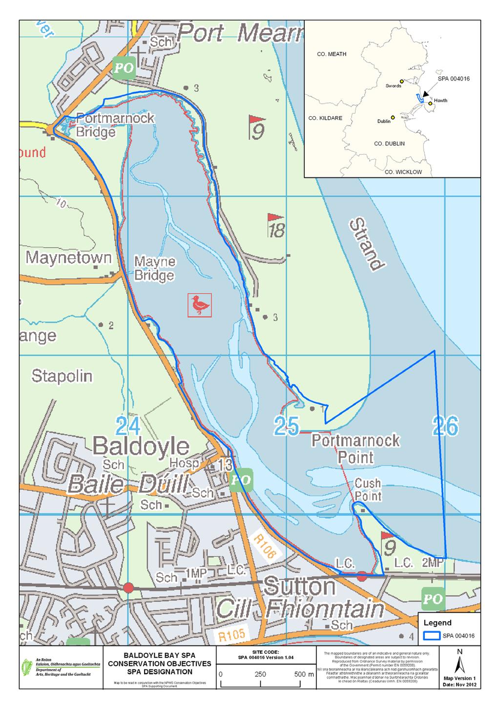
48 45
49 APPENDIX 2 Waterbird data sources Irish Wetland Bird Survey (I-WeBS) I-WeBS began in the Republic of Ireland in 1994/95 and aims to monitor wintering (non-breeding) waterbird populations at the wetland sites upon which they rely. Counts are carried out by volunteers and professional staff of the partner organisations across the months September to March of each year. I-WeBS counts take place on a rising tide or close to high tide. For further information please refer to Crowe (2005). The I-WeBS Programme monitors the larger coastal wetland sites together with inland lakes, turloughs, rivers and callows. However the resulting dataset is incomplete for some waterbird species that utilise other habitats such as non-wetland habitat (e.g. grassland used by many species and particularly foraging geese, and swans), non-estuarine coastline, small and ephemeral wetlands and the open sea; the latter of which is obviously difficult to monitor from land-based surveys (Crowe, 2005). A number of additional and special surveys are therefore conducted on an annual or regular basis and data collected are, where appropriate, integrated into the I-WeBS database. These surveys include those undertaken for swan and geese species that forage typically during daylight hours across terrestrial habitats (e.g. grassland, arable fields) using coastal wetlands sites at night when they congregate to roost. Some of the additional surveys are carried out at certain times, aimed at providing a better estimate of numbers (e.g. Greylag Geese) and for some species an assessment of breeding success during the previous summer (e.g. Light-bellied Brent Geese). These surveys are introduced briefly below and more information is provided in Crowe (2005). Swan Surveys Coordinated international censuses are carried out of the wintering populations of Whooper Swan (Cygnus cygnus) and Bewick s Swan (Cygnus columbianus bewickii) at four or five-yearly intervals. The surveys are organised by I-WeBS, the Irish Whooper Swan Study group (IWSSG) and WWT. Greenland White-fronted Goose Greenland White-fronted Geese are concentrated at relatively few sites during winter, many of which are non-wetland habitats. The species is therefore not covered adequately by the I-WeBS programme. The Greenland White-fronted Goose census was initiated in the late 1970 s and is carried out by NPWS in Ireland and by JNCC and Scottish Natural Heritage (SNH) in Scotland. Greylag Geese Data for the Icelandic breeding population of Greylag Goose that winters in Ireland are taken from special surveys organised through I-WeBS and undertaken during November each year. The surveys aim to assess the distribution and status of the migratory flocks wintering in Ireland and focus on known feeding areas (grassland & agricultural land). When calculating population estimates of the Icelandic birds, data collected are adjusted to account for feral flocks that also occur within Ireland. Barnacle Goose (Branta leucopsis) A wintering population from the northeast Greenland breeding population winters mainly on offshore islands along the west coast of Ireland. An aerial survey is conducted of the principal wintering areas every four to five years. Light-bellied Brent Geese Special autumn surveys of this species have been conducted since 1996, organised in Ireland by the Irish Brent Goose Research Group (IBGRG). The survey is currently conducted on a bi-annual basis during the month of October which coincides with the autumn arrival of the species. Data collected are integrated into the I-WeBS database. 46
50 APPENDIX 3 Analysing population trends: a synopsis Monitoring of non-breeding waterbirds has been undertaken by the Irish Wetland Bird Survey (I-WeBS) and its partner, WeBS in Northern Ireland, since the mid 1990 s. For such long-term count data, there is clearly a need to assess long-term trends in a consistent and objective manner (Atkinson et al. 2006). The first stage in the analytical process involves the use of the Underhill Program (Underhill & Prŷs- Jones, 1994) which models the raw monthly counts using a Generalised Linear Model (GLM). As part of this process, it accounts for changes in numbers at the site and the timing of the count (month, year) while also taking into account completed counts and trends at other sites. When counts at a site are flagged as poor quality (e.g. due to poor visibility) or where there are missing values in a given month, then the modelled values are used. This imputation process is used widely to replace missing data points (e.g. Houlahan et al. 2000; Atkinson et al. 2006; Leech et al. 2002; Gregory et al. 2005; Crowe et al. 2008). The resulting dataset is therefore complete for all months and seasons and comprises a combination of actual count data and imputed count data. This complete dataset is then modelled using a Generalised Additive Models (GAM) which fits a smoothed curve to the counts. GAMs are non-parametric and flexible extensions of the generalised linear model where the linear predictor of the GLM is replaced by a general additive predictor which allows mean abundance to vary as a smooth function of time. Count data are assumed to follow independent Poisson distribution with 0.3T degrees of freedom (e.g. after Atkinson et al. 2006). The application of GAMs to analyse population trends was applied to UK farmland birds by Fewster et al. (2000) and has since been adopted for modelling waterbird trends elsewhere, for example, the UK WeBS Alert system (Leech et al. 2002). Smoothed count data for a site are then indexed to assess population trends over time. An index number can be defined as a measure of population size in one year expressed in relation to the size of the population in another selected year (Leech et al. 2002). Changes in the index numbers can therefore explain the pattern of population change over time (Underhill & Prŷs-Jones, 1994). Annual indices are calculated separately for each species at a site. For each year included in an analysis, a total is obtained by summing the number of birds present in a predetermined number of months. The final year in the series of totals is then scaled to equal 100 (please see example in table). Index values in any given year therefore represent the number of individuals relative to those present in the final year. As this process is the same across all species and all sites analysed it allows for some useful comparisons. Count Data Index Un-smoothed indices are also calculated and provide a means of examining ( eye-balling ) the variation across time and can also be used to provide a measure of the mean annual change over the entire period. However, the GAM extension to the methodology and resultant smoothed indices allows for the calculation of proportional change in population size between one season and another. This latter calculation is used in Section 4.2 whereby trends are calculated for the long-term 12-year period ( ) and the recent five-year period ( ). The values given represent the percentage change in index (population) values across the specified time period, calculated by subtracting the smoothed index value at the start of the time-frame (1995) from the smoothed index value in the reference year (2007):- Change = ((I y I x) / I x ) x 100 where I y is the index from the current year and I x is the index value at the start of the selected time period (see example below) The reference year is the penultimate year in the time series because, when smoothing, the GAM takes into account values from both the preceding and following year. The last value in the smoothed dataset (2008) is therefore likely to be the least robust because it has no following year. The final result is therefore % change in population size across a specified time period. Larger values indicate larger proportional changes in population size; positive values indicating relative increases while negative values indicate relative decreases over the specified time period. 47
51 Worked example Year Unsmoothed Index Smoothed Index Term Change 5YR YR ALL YR Further information on population indexing and trend analysis can be found in various references; for particular reference to waterbirds see Leech et al (2002) and Atkinson et al. (2006). For information on the UK WeBS Alerts system, please see Thaxter et al. (2010). Limitations The months chosen for the calculation of population indices aim to reflect the months when the populations at a site are the most stable, excluding months when there may be fluctuations due to passage populations. Despite this, some datasets still present a high degree of variability or fluctuation both within and between years. Because of this, we assess each species separately and take into account where a species shows a history of wide fluctuations between years (within national dataset), or where a species naturally exhibits within-season fluctuations (e.g. species considered to have weak site faithfulness). Where necessary the results of the trend analysis are assigned necessary caution. A high proportion of imputed counts can limit the effectiveness of the analysis to aid in the interpretation of the dataset. Species for which 50% or more of the monthly count values are imputed are excluded from analysis. But sometimes the calculation of population change may involve a comparison between winters where, at least one has a value based on a high proportion of imputed data. Where data for adjacent winters are relatively complete this is not a serious concern because of the smoothing technique used. However, where data for a number of consecutive winters rely heavily on imputed data then the resulting result is considered less reliable (Thaxter et al. 2010). Where necessary the results of the trend analysis are assigned necessary caution. Despite the smoothing effects of the GAM analysis, interpretation of population trends may sometimes still be difficult. Therefore we calculate proportional change in the population across differing time periods (e.g. 12-year, 10-year and 5-year periods) to assess more effectively how the population has fared over time. 48
52 APPENDIX 4 Waterbird species codes AE Arctic Tern Sterna paradisaea BY Barnacle Goose Branta leucopsis BA Bar-tailed Godwit Limosa lapponica BE Bean Goose Anser fabalis BS Bewick s Swan Cygnus columbianus AS Black Swan Cygnus atratus BH Black-headed Gull Chroicocephalus ridibundus BN Black-necked Grebe Podiceps nigricollis BW Black-tailed Godwit Limosa limosa BV Black-throated Diver Gavia arctica BG Brent Goose Branta bernicla CG Canada Goose Branta canadensis CM Common Gull Larus canus CS Common Sandpiper Actitis hypoleucos CX Common Scoter Melanitta nigra CN Common Tern Sterna hirundo CO Coot Fulica atra CA Cormorant Phalacrocorax carbo CU Curlew Numenius arquata CV Curlew Sandpiper Calidris ferruginea DN Dunlin Calidris alpina GA Gadwall Anas strepera GP Golden Plover Pluvialis apricaria GN Goldeneye Bucephala clangula GD Goosander Mergus merganser GB Great Black-backed Gull Larus marinus GG Great Crested Grebe Podiceps cristatus ND Great Northern Diver Gavia immer NW Greenland White-fronted Goose Anser albifrons flavirostris GK Greenshank Tringa nebularia H. Grey Heron Ardea cinerea GV Grey Plover Pluvialis squatarola GJ Greylag Goose Anser anser HG Herring Gull Larus argentatus JS Jack Snipe Lymnocryptes minimus KF Kingfisher Alcedo atthis KN Knot Calidris canutus L. Lapwing Vanellus vanellus LB Lesser Black-backed Gull Larus fuscus PB Light-bellied Brent Goose Branta bernicla hrotra ET Little Egret Egretta garzetta 49
53 LG Little Grebe Tachybaptus ruficollis AF Little Tern Sterna albifrons MA Mallard Anas platyrhynchos MU Mediterranean Gull Larus melanocephalus MH Moorhen Gallinula chloropus MS Mute Swan Cygnus olor OC Oystercatcher Haematopus ostralegus PG Pink-footed Goose Anser brachyrhynchus PT Pintail Anas acuta PO Pochard Aythya ferina PS Purple Sandpiper Calidris maritima RM Red-breasted Merganser Mergus serrator RH Red-throated Diver Gavia stellata RK Redshank Tringa totanus RP Ringed Plover Charadrius hiaticula RU Ruff Philomachus pugnax SS Sanderling Calidris alba TE Sandwich Tern Sterna sandvicensis SP Scaup Aythya marila SU Shelduck Tadorna tadorna SV Shoveler Anas clypeata SY Smew Mergus albellus SN Snipe Gallinago gallinago NB Spoonbill Platalea leucorodia DR Spotted Redshank Tringa erythropus T. Teal Anas crecca TU Tufted Duck Aythya fuligula TT Turnstone Arenaria interpres WA Water Rail Rallus aquaticus WM Whimbrel Numenius phaeopus WG White-fronted Goose Anser albifrons WS Whooper Swan Cygnus Cygnus WN Wigeon Anas penelope WK Woodcock Scolopax rusticola 50
54 APPENDIX 5 Waterbird foraging guilds (after Weller, 1999) Guild Foods Tactics Examples (1) Surface swimmer Invertebrates, vegetation & seeds Strain/sieve/sweep/dabble/gr ab/up-ending Dabbling ducks ; e.g. Shoveler, Teal, Mallard, Pintail, Wigeon, Gadwall (2) Water column diver shallow a Fish & Invertebrates; Search/grab Diving ducks e.g. Pochard, Tufted Duck, Scaup, Eider, (3) Water column diver greater depths (4) Intertidal walker, out of water (5) Intertidal walker, out of water (6) Intertidal walker, in water (7) Terrestrial, walker (e.g. grassland/marsh) a dives <3m. Fish & Invertebrates Search/grab Common Scoter, divers, grebes, Cormorant Invertebrates Search (probe)/grab Sandpipers, plovers Invertebrates, vegetation Sieve/grab/graze Fish Search/strike Grey Heron Shelduck, Avocet, Spoonbill, Wigeon, Light-Bellied Brent Goose, Fish, Invertebrates Probe, scythe, sweep/grab Spoonbill, Greenshank Fish Stalk Little Egret Invertebrates Probe Several sandpiper species Vegetation (inc. roots, Graze, peck, probe Many geese species tubers & seeds) Please note that this table refers to generalised foraging strategies and is meant as a guide only. There is a great deal of variation between sites, seasons, tidal states and indeed, individual birds themselves. For example, some waterbird species may deploy several of the methods, e.g. Shelduck may forage by sieving intertidal mud (5) or by up-ending (1) and Pintail, although generally known as a dabbling duck, does occasionally dive for food. 51
55 APPENDIX 6 Baldoyle Bay Waterbird Survey Programme 2011/12 Count Subsites Subsite name Subsite code Subsite Area (ha) Portmarnock Bridge 0UL Murragh 0UL Maynetown 0UL Mayne Bridge 0UL Stapolin 0UL Baldoyle 0UL Cush Point 0UL Burrow 0UL Strand Lodge 0UL Howth Harbour 0UL Velvet Strand 0UL Red Arches 0UL Seagrange Park 0UL Donaghmede Park 0U
56 53
57 APPENDIX 7 Baldoyle Bay Waterbird distribution (dot-density diagrams) recorded during low tide surveys (October 2011 February 2012) (NB data are presented for birds located in intertidal, subtidal and terrestrial habitats) 54
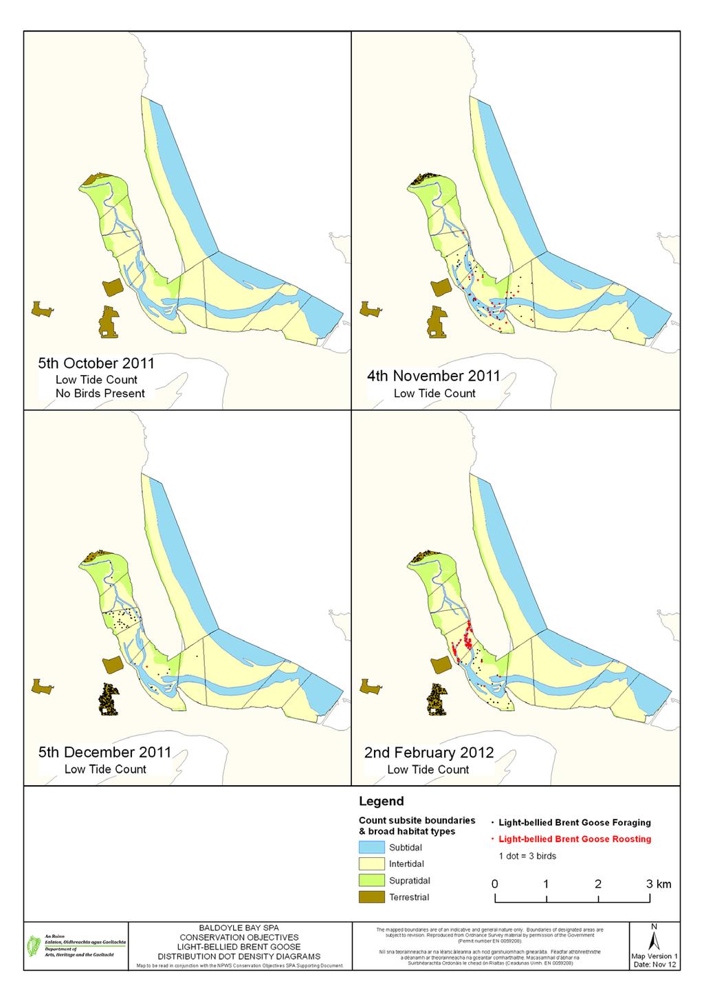
58 55
Malahide Estuary Special Protection Area. Conservation Objectives Supporting Document
 Malahide Estuary Special Protection Area (Site Code 4025) Conservation Objectives Supporting Document VERSION 1 National Parks & Wildlife Service August 2013 SUMMARY T A B L E O F C O N T E N T S PART
Tramore Back Strand Special Protection Area. Conservation Objectives Supporting Document
 Tramore Back Strand Special Protection Area (Site Code 4027) Conservation Objectives Supporting Document VERSION 1 National Parks & Wildlife Service September 2013 SUMMARY T A B L E O F C O N T E N T S
Castlemaine Harbour Special Protection Area. (Site Code 4029) Version 2. Conservation Objectives Supporting Document
 Version 2. Conservation Objectives Supporting Document") Castlemaine Harbour Special Protection Area (Site Code 4029) Version 2 Conservation Objectives Supporting Document National Parks & Wildlife Service March 2011 T A B L E O F C O N T E N T S PART ONE -
Castlemaine Harbour Special Protection Area (Site Code 4029) Version 2 Conservation Objectives Supporting Document National Parks & Wildlife Service March 2011 T A B L E O F C O N T E N T S PART ONE -
Rogerstown Estuary Special Protection Area. Conservation Objectives Supporting Document
 Rogerstown Estuary Special Protection Area (Site Code 4015) Conservation Objectives Supporting Document VERSION 1 National Parks & Wildlife Service May 2013 T A B L E O F C O N T E N T S SUMMARY PART ONE
Trawbreaga Bay Special Protection Area. Conservation Objectives Supporting Document
 Trawbreaga Bay Special Protection Area (Site Code 4034) Conservation Objectives Supporting Document VERSION 1 National Parks & Wildlife Service February 2014 TABLE OF CONTENTS SUMMARY PART ONE - INTRODUCTION...
Donegal Bay Special Protection Area. Conservation Objectives Supporting Document
 Donegal Bay Special Protection Area (Site Code 4151) Conservation Objectives Supporting Document VERSION 1 National Parks & Wildlife Service January 2012 SUMMARY T A B L E O F C O N T E N T S PART ONE
Mid-Clare Coast Special Protection Area. Conservation Objectives Supporting Document
 Mid-Clare Coast Special Protection Area (Site Code 4182) Conservation Objectives Supporting Document VERSION 1 National Parks & Wildlife Service July 2014 SUMMARY T A B L E O F C O N T E N T S PART ONE
North Bull Island Special Protection Area (Site Code 4006) South Dublin Bay and River Tolka Estuary Special Protection Area (Site Code 4024)
 South Dublin Bay and River Tolka Estuary Special Protection Area (Site Code 4024)") North Bull Island Special Protection Area (Site Code 4006) & South Dublin Bay and River Tolka Estuary Special Protection Area (Site Code 4024) Conservation Objectives Supporting Document VERSION 1 National
North Bull Island Special Protection Area (Site Code 4006) & South Dublin Bay and River Tolka Estuary Special Protection Area (Site Code 4024) Conservation Objectives Supporting Document VERSION 1 National
Blacksod Bay/Broad Haven Special Protection Area. Conservation Objectives Supporting Document
 Blacksod Bay/Broad Haven Special Protection Area (Site Code 4037) Conservation Objectives Supporting Document VERSION 1 National Parks & Wildlife Service November 2014 SUMMARY T A B L E O F C O N T E N
Cabra, Dublin 7. Appropriate assessment (screening) Report prepared for Crekav Trading GP Limited. November 2017
 Report prepared for Crekav Trading GP Limited. November 2017") Proposed development at Former CIE Lands, Carnlough Road, Cabra, Dublin 7 Appropriate assessment (screening) Report prepared for Crekav Trading GP Limited November 2017 Roger Goodwillie & Associates, Lavistown
Proposed development at Former CIE Lands, Carnlough Road, Cabra, Dublin 7 Appropriate assessment (screening) Report prepared for Crekav Trading GP Limited November 2017 Roger Goodwillie & Associates, Lavistown
4.20 BLACKWATER ESTUARY
 4.20 BLACKWATER ESTUARY LTC site code: CB Centre grid: TL9507 JNCC estuarine review site: 112 Habitat zonation: 2368 ha intertidal, 1587 ha subtidal, 766 ha nontidal Statutory status: Blackwater Estuary
OFFICE OF ENVIRONMENTAL SUSTAINABILITY
 This report has been cleared for submission by David Flynn. Eve O'Sullivan, 13/03/2018 10:52 OFFICE OF ENVIRONMENTAL SUSTAINABILITY ENVIRONMENTAL LICENSING PROGRAMME TO: Eimear Cotter, Director FROM: Brian
BROADMEADOW RIVER ESTUARY (SWORDS/MALAHIDE), CO. DUBLIN
, CO. DUBLIN") BROADMEADOW RIVER ESTUARY (SWORDS/MALAHIDE), CO. DUBLIN WATERBIRDS IN JULY AND AUGUST 2008 (with additional counts from 2004-2008) Oscar J. Merne, M.Sc. Ornithologist & Environmental Scientist August 2008
BROADMEADOW RIVER ESTUARY (SWORDS/MALAHIDE), CO. DUBLIN WATERBIRDS IN JULY AND AUGUST 2008 (with additional counts from 2004-2008) Oscar J. Merne, M.Sc. Ornithologist & Environmental Scientist August 2008
4.18 HAMFORD WATER. LTC site code:
 4.18 HAMFORD WATER LTC site code: BH Centre grid: TM2325 JNCC estuarine review site: 110 Habitat zonation: 367 ha intertidal, 106 ha subtidal, 58 ha nontidal Statutory status: Hamford Water SPA (UK9009131),
The Effects on Waterbirds of Dredging at the Cardiff Bay Barrage Report for 2005/06
 The Effects on Waterbirds of Dredging at the Cardiff Bay Barrage Report for 2005/06 Authors N.H.K. Burton & S.J. Holloway Report of work carried out by The British Trust for Ornithology under contract
National Parks and Wildlife Service
 National Parks and Wildlife Service Conservation Objectives Series Wexford Harbour and Slobs SPA 004076 Page 1 of 39 National Parks and Wildlife Service, Department of Arts, Heritage and the Gaeltacht,
THE MERSEY GATEWAY PROJECT (MERSEY GATEWAY BRIDGE) AVIAN ECOLOGY SUMMARY PROOF OF EVIDENCE OF. Paul Oldfield
 AVIAN ECOLOGY SUMMARY PROOF OF EVIDENCE OF. Paul Oldfield") HBC/14/3S THE MERSEY GATEWAY PROJECT (MERSEY GATEWAY BRIDGE) AVIAN ECOLOGY SUMMARY PROOF OF EVIDENCE OF Paul Oldfield 1 1 DESCRIPTION OF THE BIRDLIFE IN THE UPPER MERSEY ESTUARY LOCAL WILDLIFE SITE 1.1
HBC/14/3S THE MERSEY GATEWAY PROJECT (MERSEY GATEWAY BRIDGE) AVIAN ECOLOGY SUMMARY PROOF OF EVIDENCE OF Paul Oldfield 1 1 DESCRIPTION OF THE BIRDLIFE IN THE UPPER MERSEY ESTUARY LOCAL WILDLIFE SITE 1.1
National Parks and Wildlife Service
 ISSN 2009-4086 National Parks and Wildlife Service Conservation Objectives Series South Dublin Bay and River Tolka Estuary SPA 004024 Page 1 of 23 National Parks and Wildlife Service, Department of Arts,
The Effect of the Cardiff Bay Barrage on Waterbird Populations Final Report
 The Effect of the Cardiff Bay Barrage on Waterbird Populations Final Report Authors N.H.K. Burton, M.M. Rehfisch & N.A. Clark Report of work carried out by The British Trust for Ornithology under contract
Review and analysis of changes in waterbird use of the Mersey Estuary SPA, Mersey Narrows & North Wirral Foreshore pspa and Ribble & Alt Estuaries SPA
 Natural England Commissioned Report NECR173 Review and analysis of changes in waterbird use of the Mersey Estuary SPA, Mersey Narrows & North Wirral Foreshore pspa and Ribble & Alt Estuaries SPA First
Humber Management Scheme. Fact sheet: Wintering and passage birds
 Humber Management Scheme Fact sheet: Wintering and passage birds Introduction The Humber Estuary plays an international role in bird migration and is one of the most important wetland sites in the UK.
JNCC estuarine review site: ha intertidal, 1024 ha subtidal, 541 ha nontidal
 4.56 DUDDON ESTUARY LTC site code: BD Centre grid: SD1977 JNCC estuarine review site: 39 Habitat zonation: 3589 ha intertidal, 1024 ha subtidal, 541 ha nontidal Statutory status: Duddon Estuary SPA (UK9005031),
Report to Inform an Appropriate Assessment for the Firth of Forth SPA
 Report to Inform an Appropriate Assessment for the Firth of Forth SPA November 2009 No part of this report may be copied or reproduced by any means without prior written permission from Jacobs Arup - Jacobs
James Latham (Ecological Consultant)
") Identification of wintering waterbird high tide roosts on the Severn Estuary SSSI/SPA (Brean Down to Clevedon) Date: 10 th July 2015 This report has been prepared for: Natural England By: James Latham
Identification of wintering waterbird high tide roosts on the Severn Estuary SSSI/SPA (Brean Down to Clevedon) Date: 10 th July 2015 This report has been prepared for: Natural England By: James Latham
The Effect of the Cardiff Bay Barrage on Waterbird Populations 12. Distribution and Movement Studies August 2000-May 2001
 The Effect of the Cardiff Bay Barrage on Waterbird Populations 12. Distribution and Movement Studies August 2000-May 2001 Authors N.H.K. Burton, M.M. Rehfisch & N.A. Clark Report of work carried out by
APPENDIX 11O WINTERING SWAN AND GOOSE
 APPENDIX 11O WINTERING SWAN AND GOOSE Legislation The following legislation is the most relevant to whooper swan Cygnus cygnus and greylag geese Anser anser within the study area. The Conservation (Nature
ADDENDUM 1. The River Shannon & River Fergus Estuaries. Waterbird data and SIFP Areas Non-Technical Summary
 ADDENDUM 1 The River Shannon & River Fergus Estuaries Waterbird data and SIFP Areas Non-Technical Summary This addendum provides summary waterbird data for the SIFP areas. Please see Section 3.5 of the
STOUR ESTUARY Essex, Suffolk
 STOUR ESTUARY Essex, Suffolk Internationally important: Nationally important: Pintail, Grey Plover, Knot, Dunlin, Black-tailed Godwit, Redshank Great Crested Grebe, Dark-bellied Brent Goose, Shelduck,
WeBS Alerts 1998/99: Changes in numbers of wintering waterbirds in the United Kingdom at national, country and Special Protection Area (SPA) scales
 scales") WeBS s 1998/99: Changes in numbers of wintering waterbirds in the United Kingdom at national, country and Special Protection Area (SPA) scales Authors Philip W. Atkinson, Graham E. Austin, Niall H.K. Burton,
WeBS s 1998/99: Changes in numbers of wintering waterbirds in the United Kingdom at national, country and Special Protection Area (SPA) scales Authors Philip W. Atkinson, Graham E. Austin, Niall H.K. Burton,
THE PROPOSED DUBLIN ARRAY WIND FARM ASSESSMENT OF POTENTIAL IMPACTS ON SEABIRDS
 THE PROPOSED DUBLIN ARRAY WIND FARM ASSESSMENT OF POTENTIAL IMPACTS ON SEABIRDS Information in support of the Appropriate Assessment of the proposed Wind Farm Report for: Prepared by: February 2013. THE
Waterbird Disturbance Mitigation Toolkit Informing Estuarine Planning & Construction Projects
 Waterbird Disturbance Mitigation Toolkit Informing Estuarine Planning & Construction Projects Click on the Photograph to Enter Authors: N Cutts K Hemingway & J Spencer Version 3.2, March 2013 Copyright
APPENDIX 11.2 BRENT GEESE SURVEY REPORT
 APPENDIX 11.2 BRENT GEESE SURVEY REPORT Light-bellied Brent Goose presence on Alfie Byrne Road Green Space and Belcamp Park in Dublin City along route corridor for proposed aviation fuel pipeline SUMMARY
Dispersed Waterbirds Survey
 Dispersed Waterbirds Survey Title Dispersed Waterbird Survey 2002/03 Description and Summary of Results The main wetland sites are counted by the Wetland Bird Survey (WeBS) Core Counts -- monthly counts
Assessing ornithological impacts associated with wind farm developments: surveying recommendations
 Assessing ornithological impacts associated with wind farm developments: surveying recommendations This information note has been written to provide guidance to developers, Competent Authorities and others
CORE MANAGEMENT PLAN INCLUDING CONSERVATION OBJECTIVES FOR
 CYNGOR CEFN GWLAD CYMRU COUNTRYSIDE COUNCIL FOR WALES CORE MANAGEMENT PLAN INCLUDING CONSERVATION OBJECTIVES FOR TRAETH LAFAN/LAVAN SANDS, CONWAY BAY SPA (incorporating a section of Y Fenai a Bae Conwy/Menai
BLACKWATER ESTUARY Essex
 BLACKWATER ESTUARY Essex Internationally important: Nationally important: Dark-bellied Brent Goose, Golden Plover, Grey Plover, Dunlin, Black-tailed Godwit, Redshank Cormorant, Shelduck, Wigeon, Teal,
PORTSMOUTH HARBOUR Hampshire
 PORTSMOUTH HARBOUR Hampshire Internationally important: Nationally important: None Dark-bellied Brent Goose, Red-breasted Merganser, Black-tailed Godwit Site description This large harbour in the Solent
HELCOM workshop on migratory waterbirds
 HELCOM workshop on migratory waterbirds Helsinki, 20-22 November 2018 Aims: Produce maps with migration routes of waterbird species (e.g. seabirds, ducks, waders) covering the entire Baltic Sea Region.
Results of the third Non-Estuarine Waterbird Survey, including Population Estimates for Key Waterbird Species
 Results of the third Non-Estuarine Waterbird Survey, including Population Estimates for Key Waterbird Species Authors Graham Austin, Teresa Frost, Heidi Mellan, Dawn Balmer Report of work carried out by
JNCC estuarine review site: ha intertidal, 608 ha subtidal, 27 ha nontidal Statutory status: Winter waterbird interest:
 4.50 CONWY ESTUARY LTC site code: EC Centre grid: SH7976 JNCC estuarine review site: 32 Habitat zonation: 1009 ha intertidal, 608 ha subtidal, 27 ha nontidal Statutory status: N/A Winter waterbird interest:
LOUTH COUNTY COUNCIL. DRAFT LOCAL ECONOMIC & COMMUNITY PLAN Appropriate Assessment (AA) Screening Report DRAFT LECP
 Screening Report DRAFT LECP") LOUTH COUNTY COUNCIL DRAFT LOCAL ECONOMIC & COMMUNITY PLAN 2016-2022 Appropriate Assessment (AA) Screening Report A Plan for the promotion of economic and community development in County Louth TABLE OF
LOUTH COUNTY COUNCIL DRAFT LOCAL ECONOMIC & COMMUNITY PLAN 2016-2022 Appropriate Assessment (AA) Screening Report A Plan for the promotion of economic and community development in County Louth TABLE OF
Supplementary material
 Supplementary material Thomas Bregnballe, Ole Amstrup, Thomas E. Holm, Preben Clausen & Anthony D. Fox: Skjern River Valley, Northern Europe s most expensive wetland restoration project: benefits to breeding
Stour and Orwell Estuary European marine site
 Stour and Orwell Estuary European marine site English Nature s advice given under Regulation 33(2) of the Conservation (Natural Habitats &c.) Regulations 1994 English Nature s advice for Stour and Orwell
Summary of protection values of Finnish marine protection areas
 Appendix 5 Summary of protection values of Finnish marine protection areas s Table lists relevant Finnish Marine s in the vicinity of NSP2 project area and their conservation objectives. Sites are listed
WeBS Alerts 1999/2000: Changes in Numbers of Wintering Waterbirds in the United Kingdom at National, Country and SSSI Scales
 WeBS Alerts 1999/2000: Changes in Numbers of Wintering Waterbirds in the United Kingdom at National, Country and SSSI Scales Interim Report Authors Philip W. Atkinson, Mark M. Rehfisch & Mark Pollitt Data
Agreement on the Conservation of African-Eurasian Migratory Waterbirds (AEWA)
") Agreement on the Conservation of African-Eurasian Migratory Waterbirds (AEWA) A Tool for International Cooperation AEWA - An International Treaty Safeguarding Migratory Waterbirds The Agreement on the
Agreement on the Conservation of African-Eurasian Migratory Waterbirds (AEWA) A Tool for International Cooperation AEWA - An International Treaty Safeguarding Migratory Waterbirds The Agreement on the
4.12 NORTH NORFOLK COAST
 4.12 NORTH NORFOLK COAST LTC site code: CN Centre grid: TF8946 JNCC estuarine review site: 102 Habitat zonation: 3447 ha intertidal, 2490 ha subtidal, 2701 ha nontidal Statutory status: North Norfolk Coast
BirdLife International Marine Programme Marine Important Bird & Biodiversity Areas (Marine IBAs)
") Photo: Pep Arcos BirdLife International Marine Programme Marine Important Bird & Biodiversity Areas (Marine IBAs) Marguerite Tarzia- Marine Conservation Officer, BirdLife Europe marguerite.tarzia@birdlife.org
Photo: Pep Arcos BirdLife International Marine Programme Marine Important Bird & Biodiversity Areas (Marine IBAs) Marguerite Tarzia- Marine Conservation Officer, BirdLife Europe marguerite.tarzia@birdlife.org
Office of Climate, Licensing & Resource Use Environmental Protection Agency PO Box 3000 County Wexford 3 August 2010
 Kilcatherine, Eyeries, County Cork http://www.friendsoftheirishenvironment.org Office of Climate, Licensing & Resource Use Environmental Protection Agency PO Box 3000 County Wexford 3 August 2010 Westland
Point Grey Tidal Marsh Project Standwatch Surveys February 20, 2014 to March 26, 2014
 Suite 250 1380 Burrard Street Vancouver, BC V6Z 2H3 T: 604.669.0424 F: 604.669.0430 hemmera.com Point Grey Tidal Marsh Project Standwatch Surveys February 20, 2014 to March 26, 2014 Report Date July 22,
Calidris alpina schinzii Britain & Ireland/SW Europe & NW Africa
 Period 2008-2012 European Environment Agency European Topic Centre on Biological Diversity Calidris alpina schinzii Britain & Ireland/SW Europe & NW Africa Annex I International action plan Yes No Dunlin,
The Severn Estuary Special Protection Area European Marine Site
 The Severn Estuary Special Protection Area European Marine Site English Nature & the Countryside Council for Wales advice for the Severn Estuary Special Protection Area given under Regulation 33(2) of
Migratory Shorebird Conservation Action Plan
 Migratory Shorebird Conservation Action Plan The Migratory Shorebird Conservation Action Plan (MS CAP) has been developed by a broad range of stakeholders from all across the country and internationally
Skogsøy Spring Migration. Preliminary Results. Julian Bell
 Skogsøy 26 Spring Migration Preliminary Results Julian Bell 26 1 1. Introduction...4 2. Species Accounts...5 Red-throated Diver Gavia stellata...6 Black-throated Diver Gavia arctica...7 Great Northern
2008 San Francisco Bay Shorebird Census
 2008 San Francisco Bay Shorebird Census San Francisco Bay is a great place for shorebirds! The salt ponds, tidal flats, marshes and seasonal wetlands provide important habitat for over a million resident
3 March 2015 The Director Sustainable Fisheries Section Department of the Environment GPO Box 787 CANBERRA ACT 2601
 3 March 2015 The Director Sustainable Fisheries Section Department of the Environment GPO Box 787 CANBERRA ACT 2601 SustainableFisheries@environment.gov.au Dear Director, Birdlife Australia welcomes the
Site Improvement Plan. Ouse Washes SPA. Improvement Programme for England's Natura 2000 Sites (IPENS) Planning for the Future
 Planning for the Future") Improvement Programme for England's Natura 2000 Sites (IPENS) Planning for the Future Site Improvement Plan Ouse Washes Site Improvement Plans (SIPs) have been developed for each Natura 2000 site in England
Improvement Programme for England's Natura 2000 Sites (IPENS) Planning for the Future Site Improvement Plan Ouse Washes Site Improvement Plans (SIPs) have been developed for each Natura 2000 site in England
Assessment of Supporting Habitat (Docks) for Use by Qualifying Features of Natura 2000 Sites in the Liverpool City Region
 for Use by Qualifying Features of Natura 2000 Sites in the Liverpool City Region") Assessment of Supporting Habitat (Docks) for Use by Qualifying Features of Natura 000 Sites in the Liverpool City Region Ornithology Report Report Ref: 457.005 August 05 Assessment of Supporting Habitat
Assessment of Supporting Habitat (Docks) for Use by Qualifying Features of Natura 000 Sites in the Liverpool City Region Ornithology Report Report Ref: 457.005 August 05 Assessment of Supporting Habitat
Dublin Port Masterplan 2040 Reviewed 2018 Natura Impact Statement. April
 Reviewed 2018 April 2018 www.dublinport.ie/masterplan Dublin Port Masterplan 2040 Reviewed 2018 Dublin Port Masterplan 2040 Reviewed 2018 DOCUMENT CONTROL SHEET Client Dublin Port Company Project Title
Varangerbotn, Karlebotn and Meskelv are strategically situated innermost
 Varangerbotn Karlebotn Meskelv WWW.BIOFORSK.NO/FUGLETURISME Information sheet for the project «Bird tourism in central and eastern Finnmark», a project part of «The natural heritage as a value creator
BC Coastal Waterbird Survey Protocol. Instructions for Participants
 Instructions for Participants Background The coastal marine habitat of British Columbia is home to many species of waterbirds and supports some of the highest densities of seabirds, waterfowl, and shorebirds
Branta leucopsis East Greenland/Scotland & Ireland
 Period 2008-2012 European Environment Agency European Topic Centre on Biological Diversity Branta leucopsis East Greenland/Scotland & Ireland Annex I International action plan Yes No Barnacle Goose, Branta
Site Improvement Plan. Solway Firth SAC. Improvement Programme for England's Natura 2000 Sites (IPENS) Planning for the Future
 Planning for the Future") Improvement Programme for England's Natura 2000 Sites (IPENS) Planning for the Future Site Improvement Plan Solway Firth Site Improvement Plans (SIPs) have been developed for each Natura 2000 site in England
Improvement Programme for England's Natura 2000 Sites (IPENS) Planning for the Future Site Improvement Plan Solway Firth Site Improvement Plans (SIPs) have been developed for each Natura 2000 site in England
The UK Wintering Waterbird Indicator: New developments towards a more comprehensive assessment of trends in the wintering waterbird assemblage
 The UK Wintering Waterbird Indicator: New developments towards a more comprehensive assessment of trends in the wintering waterbird assemblage Authors G. E. Austin, A. N. Banks & M. M. Rehfisch A report
DORNOCH FIRTH Highland
 DORNOCH FIRTH Highland Internationally important: Nationally important: Greylag Goose Whooper Swan, Wigeon, Teal, Bar-tailed Godwit Site description Dornoch Firth is a relatively narrow and steepsided
STRATEGIC ENVIRONMENTAL ASSESSMENT SCREENING STATEMENT MAINTENANCE ACTIVITIES COASTAL PROTECTION SCHEMES OFFICE OF PUBLIC WORKS ENGINEERING SERVICES
 STRATEGIC ENVIRONMENTAL ASSESSMENT SCREENING STATEMENT MAINTENANCE ACTIVITIES OF COASTAL PROTECTION SCHEMES UNDER THE RESPONSIBILITY OF THE OFFICE OF PUBLIC WORKS ENGINEERING SERVICES OFFICE OF PUBLIC
Table of Contents. 1 Introduction...3
 Cork County Council Proposed Amendment No2 to Midleton Local Area Plan (Carrigtwohill North Framework Masterplan) Habitats Directive Screening Statement Prepared by Cork County Council Planning Policy
Site Improvement Plan. Upper Nene Valley Gravel Pits SPA. Improvement Programme for England's Natura 2000 Sites (IPENS) Planning for the Future
 Planning for the Future") Improvement Programme for England's Natura 2000 Sites (IPENS) Planning for the Future Site Improvement Plan Upper Nene Valley Gravel Pits Site Improvement Plans (SIPs) have been developed for each Natura
Improvement Programme for England's Natura 2000 Sites (IPENS) Planning for the Future Site Improvement Plan Upper Nene Valley Gravel Pits Site Improvement Plans (SIPs) have been developed for each Natura
General report format, ref. Article 12 of the Birds Directive, for the report
 Annex 1: General report format, ref. Article 12 of the Birds Directive, for the 2008-2012 report 0. Member State Select the 2 digit code for your country, according to list to be found in the reference
Sutton to Sandycove Cycleway & Footway. Interim Works Bull Wall (Wooden Bridge) To Causeway Road. Habitats Directive Assessment Screening Report
 To Causeway Road. Habitats Directive Assessment Screening Report") Sutton to Sandycove Cycleway & Footway Interim Works Bull Wall (Wooden Bridge) To Causeway Road Habitats Directive Assessment Screening Report FINAL ISSUE MARCH 2014 Client Civic Offices Wood Quay Dublin
Sutton to Sandycove Cycleway & Footway Interim Works Bull Wall (Wooden Bridge) To Causeway Road Habitats Directive Assessment Screening Report FINAL ISSUE MARCH 2014 Client Civic Offices Wood Quay Dublin
Farr wind farm: A review of displacement disturbance on dunlin arising from operational turbines
 Farr wind farm: A review of displacement disturbance on dunlin arising from operational turbines 2002-2015. Alan H Fielding and Paul F Haworth September 2015 Haworth Conservation Haworth Conservation Ltd
WATERBIRD MONITORING IN THE CONSERVATION ZONE OF THE CREERY WETLANDS. December 1998 to April 2004
 WATERBIRD MONITORING IN THE CONSERVATION ZONE OF THE CREERY WETLANDS December 1998 to April 2004 Prepared for: RPS Bowman Bishaw Gorham Pty Ltd, 290 Churchill Avenue, Subiaco, WA Prepared by: M.J. & A.R.
A Rising Tide: Conserving Shorebirds and Shorebird Habitat within the Columbia River Estuary
 A Rising Tide: Conserving Shorebirds and Shorebird Habitat within the Columbia River Estuary By Vanessa Loverti USFWS Migratory Birds and Habitat Programs, Portland, Oregon May 28, 2014 Outline of Talk
Wetland Bird Survey (Core Counts)
") Wetland Bird Survey (Core Counts) Title Wetland Bird Survey (WeBS) Core Counts 1954 to present Description and Summary of Results The UK is known to hold large numbers of waterbirds in the non-breeding
Wetland Bird Survey (Core Counts) Title Wetland Bird Survey (WeBS) Core Counts 1954 to present Description and Summary of Results The UK is known to hold large numbers of waterbirds in the non-breeding
4.6 FIRTH OF FORTH. LTC site code:
 4.6 FIRTH OF FORTH LTC site code: BF Centre grid: NT0182 JNCC estuarine review site: 88 Habitat zonation: 5713 ha intertidal, 8032 ha subtidal, 64 ha nontidal Statutory status: Firth of Forth SPA (UK9004411),
SoN 2015: Landmark report shows European biodiversity going lost at unacceptable rates: intensive agriculture main culprit
 Brussels, 20 May 2015 SoN 2015: Landmark report shows European biodiversity going lost at unacceptable rates: intensive agriculture main culprit Landmark report shows European biodiversity going lost at
Branta leucopsis Russia/Germany & Netherlands
 Period 2008-2012 European Environment Agency European Topic Centre on Biological Diversity Branta leucopsis Russia/Germany & Netherlands Annex I International action plan Yes No Barnacle Goose, Branta
Possible new marine Special Areas of Conservation and Special Protection Areas in Wales
 Possible new marine Special Areas of Conservation and Special Protection Areas in Wales Photo credit - PGH Evans / Seawatch Foundation // February 2015 www.naturalresourceswales.gov.uk This leaflet provides
LANCASTER BYPASS WINTER 2000/2001
 LANCASTER BYPASS WINTER 2000/2001 Authors S. J. Holloway & N. A. Clark Report of work carried out by The British Trust for Ornithology under contract to Lancashire County Council British Trust for Ornithology
State of nature in the EU: results from the reporting under the nature directives
 State of nature in the EU: results from the reporting under the nature directives 2007-2012 18 th Meeting Co-ordination Group for Biodiversity and Nature 12 March 2015 1 EEA technical report Contents Introduction
Summaries of Sub-regional Trends in Density Indices PROCEEDINGS 1
 Trends Observed for Selected Marine Bird Species during 1993- Winter Aerial Surveys, Conducted by the PSAMP Bird Component (WDFW) in the Inner Marine Waters of Washington State David R. Nysewander, Joseph
Calidris alpina schinzii Baltic/SW Europe & NW Africa
 Period 2008-2012 European Environment Agency European Topic Centre on Biological Diversity Calidris alpina schinzii Baltic/SW Europe & NW Africa Annex I International action plan Yes No Dunlin, Calidris
Interim Project Report: Year One
 Interim Project Report: Year One Deborah Whitfield October 2017 Hampshire and Isle of Wight Wildlife Trust 1 Publication Details This document should be cited as: Whitfield, D (2017) Solent Waders and
Local regional, national and international importance of the wader populations of the Dee Estuary and at Point of Ayr, Clwyd
 BTO Research Report No 88 Local regional, national and international importance of the wader populations of the Dee Estuary and at Point of Ayr, Clwyd A report by the British Trust for Ornithology to Nicholas
Roberts Bank Terminal 2 Project Field Studies Information Sheet
 January 2013 Port Metro Vancouver is continuing field studies in January as part of ongoing environmental and technical work for the proposed. The is a proposed new multi berth container terminal which
Screening Report for Appropriate Assessment of a proposed student residence development at University College Dublin, Dublin 4
 Screening Report for Appropriate Assessment of a proposed student residence development at University College Dublin, Dublin 4 1 Compiled by OPENFIELD Ecological Services Pádraic Fogarty, MSc MIEMA For
working today for nature tomorrow Low tide survey of The Wash Special Protection Area Final report of the winter shorebird survey
 Report Number 589 Low tide survey of The Wash Special Protection Area Final report of the winter 2002-2003 shorebird survey English Nature Research Reports working today for nature tomorrow English Nature
SPECIES ACTION PLAN. Rhinolophus ferrumequinum 1 INTRODUCTION 2 CURRENT STATUS 3 CURRENT FACTORS AFFECTING 4 CURRENT ACTION
 GREATER HORSESHOE BAT Rhinolophus ferrumequinum Hampshire Biodiversity Partnership 1 INTRODUCTION The greater horseshoe bat has been identified by the UK Biodiversity steering group report as a species
BP Conservation Programme. Final Report
 BP Conservation Programme Final Report Project title: Conserving the lakes of Son-Kol and Chatyr-Kol for waterbirds Location: Kyrgyz Republic Organisation: Karatal-Japyryk State Reserve Address: #3, 1-Maya
Determinants of bird habitat use in TIDE estuaries
 Determinants of bird habitat use in TIDE estuaries Authors: Franco, A., Thomson, S. & N.D. Cutts Institute of Estuarine and Coastal Studies (IECS), University of Hull, UK Acknowledgments The authors would
Project Summary. Predicting waterbird nest distributions on the Yukon-Kuskokwim Delta of Alaska
 Project Summary 1. PROJECT INFORMATION Title Project ID Predicting waterbird nest distributions on the Yukon-Kuskokwim Delta of Alaska WA2012_22 Project Period July 1, 2012 to June 30, 2014 Report submission
North Solent Shoreline Management Plan. Appendix J: Appropriate Assessment
 North Solent Shoreline Management Plan Appendix J: Appropriate Assessment Contents Page No J1 INTRODUCTION...1 J1.1 Background...1 J1.2 Role of Organisations in the Appropriate Assessment Process...8
Sanderling. Appendix A: Birds. Calidris alba. New Hampshire Wildlife Action Plan Appendix A Birds-67
 Sanderling Calidris alba Federal Listing State Listing Global Rank State Rank Regional Status N/A N/A G5 SNR High Photo by Pamela Hunt Justification (Reason for Concern in NH) Populations of several migratory
Analysis of sea-watching data from Holme Bird Observatory, Norfolk
 Analysis of sea-watching data from Holme Bird Observatory, Norfolk BTO Authors Aonghais S.C.P. Cook, Chris Thaxter, Lucy J. Wright, Nick J. Moran, Niall H.K. Burton, Jed Andrews, Sophie Barker and Fred
Low Tide Counts of Water Birds at Sabaki River Mouth Malindi, Kenya in
 Low Tide Counts of Water Birds at Sabaki River Mouth Malindi, Kenya in 4- A Conservation Research Project by A Rocha Kenya Simon Valle & Colin Jackson A Rocha Kenya, Watamu Ornithology Section, Zoology
Conserving the mangrove forests.
 Conserving the mangrove forests. The mangrove forests of Pretty Pool Creek and Four Mile Creek not only lend a unique beauty to the area, they also serve an important role in the environment s ecosystem.
Impact of wind farms on birds and bats
 Impact of wind farms on birds and bats Dr. Hermann Hötker Michael-Otto-Institut im NABU BirdLife Partner Germany Methods Disturbance and Displacement Collision mortality Repowering download: http://bergenhusen.nabu.de/bericht/voegelregenergien.pdf
Roberts Bank Terminal 2 Project Field Studies Information Sheet
 May 2013 Port Metro Vancouver is continuing field studies in May as part of ongoing environmental and technical work for the proposed Roberts Bank Terminal 2 Project. Roberts Bank Terminal 2 Project The
LOCH LEVEN NATIONAL NATURE RESERVE (NNR) Proposed Local Access Guidance
 Proposed Local Access Guidance") LOCH LEVEN NATIONAL NATURE RESERVE (NNR) Proposed Local Access Guidance Summary This paper briefly outlines the rationale behind the proposed local access guidance for Loch Leven NNR. Introduction SNH
LOCH LEVEN NATIONAL NATURE RESERVE (NNR) Proposed Local Access Guidance Summary This paper briefly outlines the rationale behind the proposed local access guidance for Loch Leven NNR. Introduction SNH
Working with wildlife A DAY IN THE LIFE
 EPA ACTIVITY WORKSHEET STUDENT PAGE 1 7 Theme Student Sheet. This is the story of a scientist and their work on a day to day basis. Objectives To give students an insight into the work of scientists and