Results of the third Non-Estuarine Waterbird Survey, including Population Estimates for Key Waterbird Species
|
|
|
- Silas Curtis
- 5 years ago
- Views:
Transcription
1 Results of the third Non-Estuarine Waterbird Survey, including Population Estimates for Key Waterbird Species Authors Graham Austin, Teresa Frost, Heidi Mellan, Dawn Balmer Report of work carried out by The British Trust for Ornithology British Trust for Ornithology The British Trust for Ornithology, The Nunnery, Thetford, Norfolk IP24 2PU Registered Charity No
2 British Trust for Ornithology Results of the third Non-Estuarine Waterbird Survey, including Population Estimates for Key Waterbird Species Graham Austin, Teresa Frost, Heidi Mellan, Dawn Balmer Published in by the British Trust for Ornithology The Nunnery, Thetford, Norfolk, IP24 2PU, UK Copyright British Trust for Ornithology 29 ISBN All rights reserved. No part of this publication may be reproduced, stored in a retrieval system or transmitted, in any form, or by any means, electronic, mechanical, photocopying, recording or otherwise, without the prior permission of the publishers
3 CONTENTS Page No. List of Tables... 3 List of Figures... 3 List of Appendices... 5 EXECUTIVE SUMMARY INTRODUCTION METHODS Winter Shorebird Count (WSC) Non-estuarine Waterbird Survey 1997/98 (NEWS I) Non-estuarine Waterbird Survey 26/7 (NEWS II) Non-estuarine Waterbird Survey 215/16 (NEWS III) Analysis Waterbird population estimates Strandline deposits Comparison with Population Estimates Methodology for the Non-estuarine Coast from NEWS II RESULTS Coverage Population Estimates Population Estimates for NEWS II and Earlier Surveys Distributions NEWS Report Online: Regional Distribution and Estimates Designated Sites Strandline Deposits Data Collection and Collation DISCUSSION Population Estimates Species Distribution along the Non-estuarine Coast Indications of Change for Key Wader Species Acknowledgements References Appendices
4 2
5 List of Tables Page No. Table 2.5.i Scoring matrix for strandline deposits Table 3.2.i The population estimates of the key species of waterbird on the non-estuarine coast of the UK and its constituent countries, Great Britain and crown dependencies during winter 215/ Table 3.3.i Population estimates of the key species of wader on the non-estuarine coast of the UK and its constituent countries during winter 26/7 using the revised methodology, 26/7 estimates using the previous methodology (Austin et al. 28) and 215/16 estimates using the revised methodology List of Figures Page No. Figure 2.5.i Diagrammatic representation of bootstrap realisations based on a country (A) comprising three regions 1, 2 and Figure 3.1.i Coverage obtained for NEWS III Figure 3.3.i All habitat population point estimates and 95% confidence intervals for key species of wader using the revised methodology for data from all four surveys Figure 3.3.ii Intertidal-only habitat population point estimates and 95% confidence intervals for key species of wader using the revised methodology for data from all four surveys Figure 3.4.i Species location centroids for NEWS III surveys Figure 3.4.ii Non-estuarine coast with high density and diversity of key species of wader Figure 3.7.i Inventory of strandline deposits of beach-cast seaweed for the UK and Republic of Ireland
6 4
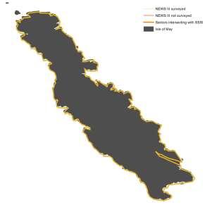
7 List of Appendices Page No. Appendix 1 Regional coverage for NEWS III Appendix 2a NEWS III counts for key designated sites Appendix 2b Appendix 2c Winter Shorebird Count (WSC) and Non-estuarine Waterbird Survey (NEWS) I, II and III counts for key designated sites NEWS III stretches intersecting with designated site boundary and coverage during NEWS III Appendix 3 NEWS III raw count distribution maps Appendix 4 Instructions for counters taking part in NEWS III, including guidance on recording strandline deposits
8 6
9 EXECUTIVE SUMMARY During December, January and February of the winter of 215/16 the BTO organised the third Non-estuarine Waterbird Survey (NEWS III), the fourth in a series of coordinated winter surveys of the non-estuarine coast of the UK, following the Winter Shorebird Count (WSC) in 1984/85 (Moser 1987), NEWS I in 1997/98 (Rehfisch et al. 23) and NEWS II in 26/7 (Austin et al. 28). The basic field-work methodology has remained unchanged across all four surveys. The data recorded and the manner in which they have been collated has evolved to allow more robust estimates of waterbird numbers to be made. These changes have implications when it comes to making comparisons between the surveys. A brief overview of the four surveys is therefore provided. This document reports population estimates of key bird species on the non-estuarine coast of the UK and its constituent countries, Great Britain and crown dependencies during the winter of 215/16. These new population estimates for waders, and where appropriate similar estimates for wildfowl, will feed directly into revised population estimates for wintering waterbirds that are in preparation. NEWS III achieved 53% coverage of the non-estuarine coast of the UK, an improvement on 44% for NEWS II. Counters were also asked to score the extent of deposits of beach-case seaweed, enabling estimates of relative amounts of this resource to be produced. Areas with the highest amounts of beach-cast seaweed included Ards in Northern Ireland, Anglesey in Wales, and Shetland, Orkney and West Scotland. A total of 217 bird species/sub-species/races and 18 mammal species were recorded during the survey. A bootstrap approach was used to derive regional (county) estimates of the populations of 43 key coastal waterbird species to be found on the non-estuarine coast during the winter of 215/16 and during the three previous surveys. These in turn were used to derive separate estimates for the UK and each of its four constituent countries, Great Britain and crown dependencies. Population estimates from NEWS III for the four non-estuarine specialists, Ringed Plover, Sanderling, Purple Sandpiper and Turnstone were 16,23, 12,93, 1,184 and 25,988 individuals respectively. Compared to NEWS II estimates, the population point estimates for Ringed Plover, Purple Sandpiper and Turnstone decreased, although only in the case of Turnstone did the 95% confidence intervals for the two surveys not overlap. The point estimate for Sanderling increased from NEWS II. Further analyses of these data are planned targeting publication in peer-reviewed journals of investigations of population change and the importance of beach-cast seaweed to wader species. 7
10 8
11 1. INTRODUCTION During December 215 and January and February 216 the BTO ran the fourth in a series of intermittent surveys of the non-estuarine coast of the UK (NEWS III), following a tradition that began during the winter 1984/85 under the guise of the Winter Shorebird Count (WSC: Moser 1987) and continued during the winter of 1997/98 (NEWS I: Rehfisch et al. 23) and 26/7 (NEWS II: Austin et al. 28). As with NEWS II, NEWS III was a joint survey of UK and the Republic of Ireland in conjunction with the Irish Wetland Bird Survey; only results for the UK are presented in this report. Results from NEWS II for 26/7 showed that some species, such as Sanderling Calidris alba, Purple Sandpiper Calidris maritima, Bar-tailed Godwit Limosa lapponica and Turnstone Arenaria interpres, had declined on the UK s non-estuarine coast since the first survey in 1984/85, contributing to overall UK population declines. It is vital that we monitor these and other species on this habitat as many occur in internationally important numbers and this habitat may support significant proportions of some species populations. Despite associated Special Protection Area (SPA) and Site of Special Scientific Interest (SSSI) designation for several sites, the non-estuarine coast is inadequately monitored by the primary scheme for monitoring the UK s wintering waterbirds, the Wetland Bird Survey (WeBS). A significant factor in the abundance of some wader species on the open coast is likely to be the amount of beach-cast seaweed deposited by winter storms on the strandline, which can support high numbers of macro-invertebrates as it starts to decompose. There is, however, uncertainty over the extent to which bird populations on the coast are actually reliant on beach-cast seaweed, particularly in the UK where very little research has been carried out. For the first time, during NEWS III, volunteers were also asked to score the extent of seaweed washed up on shore as they recorded the number of birds using coastal sites. Furthermore, changes in distribution of waders within the UK have been found to be associated with changes in weather (Rehfisch et al. 24, Austin & Rehfisch 25), and declines recorded in the UK could be explained by increases in some northern European countries (Maclean et al. 28). It has been demonstrated at the flyway scale that distributions of waders and other waterbirds are responding strongly to medium-term trends in climate (Maclean et al. 28, Lehikoinen et al. 213). Information collected through NEWS III is therefore applicable to a host of research questions relating to waterbird use of the non-estuarine coast. NEWS III had the following objectives: To contribute to revised non-estuarine waterbird population estimates for the UK and its constituent countries, Great Britain and crown dependencies, and associated 1% thresholds, which are available for future reporting for Article 12 of the EU Birds Directive. To contribute to revised all-ireland non-estuarine waterbird population estimates, incorporating results for Northern Ireland with results from the Republic of Ireland. To contribute to the production of northwest Europe and East Atlantic Flyway population estimates. To contribute to improved data on seaduck numbers and distribution, as well as potentially other non-estuarine bird groups, mammals and habitat features. To provide data for incorporation into the Scottish wintering waterbird indicator and the Marine Strategic Framework Directive (MSFD) non-breeding waterbird indicator. 9
12 To contribute to Common Standards Monitoring of SPAs and SSSIs in each of the four countries of the UK. To contribute to a revised assessment of the status of species on non-estuarine SPAs and SSSIs in each of the four countries of the UK and enable comparison with the non-estuarine coast in each region as a whole. To collect data on strandline deposits of beach-cast seaweed and their associated importance for birds (and other biodiversity). This will represent a baseline inventory of the resource, with potential application to a host of related research questions. To provide data for use in a range of research questions relating to waterbirds of the nonestuarine coast; including exploring patterns of distribution in response to climate change and other environmental change. This document reports population estimates for waterbirds and seabirds on the non-estuarine coast of the UK during the winter of 215/16. A revised methodology is used compared to reports on earlier surveys. This report contains results using the revised methodology for the earlier surveys for comparison with the most recent survey. It also summarises information on the amount of beachcast seaweed recorded on NEWS survey visits, a likely key factor in determining the abundance of some wader species. The results update our current knowledge of numbers of waterbirds, in particular waders, on the UK s coast, and will feed in to updated winter waterbird population estimates. 1
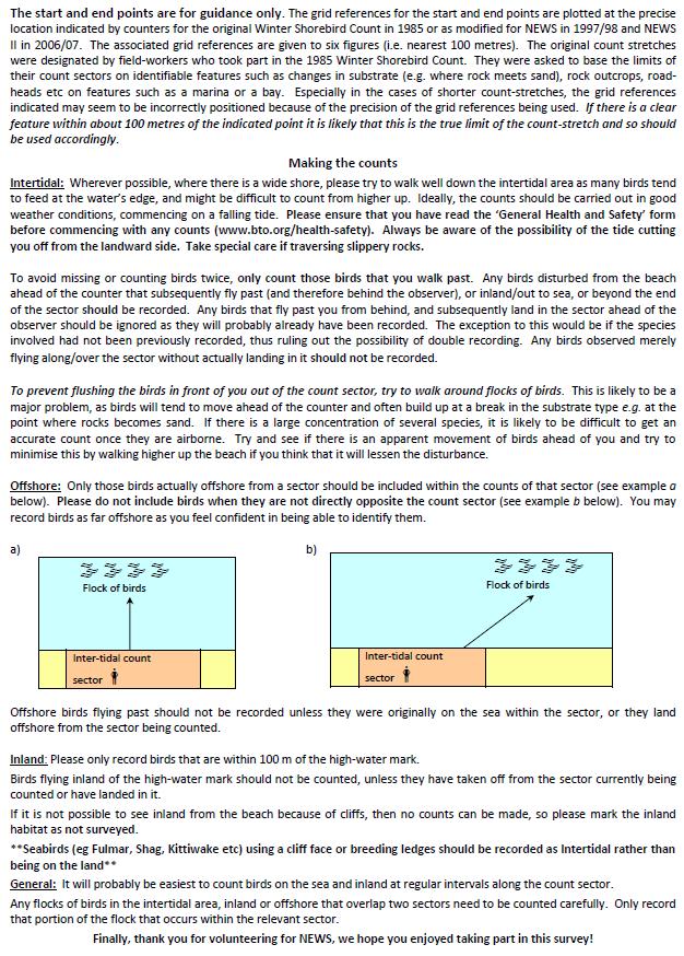
13 2. METHODS While the basic field-work methodology has remains unchanged across all four surveys, the data recorded and the manner in which they have been collated have evolved to allow more robust estimates of waterbird numbers to be made. However, these changes have implications when it comes to making comparisons between the four surveys. A brief overview of each survey is therefore pertinent. 2.1 Winter Shorebird Count (WSC) The WSC ostensibly covered all open coast habitat where the intertidal habitat was considered suitable for waders. Organisationally, the UK coastline was divided into 41 administrative regions (essentially based on the accepted county boundaries at that time) and each region assigned to a regional organiser. These regions were further sub-divided into a variable number of administrative areas (essentially dictated by the representation of the coastline that could be copied from 1:5, scale maps on to an A4 sheet of paper). Within each area, the coastline was further divided into Count Stretches, defined by the surveyors and generally demarcated by changes in habitat (e.g. boundaries between sand and rock) or physical features (e.g. creeks, road-heads). The Count Stretches within each area were numbered sequentially using a coding system based on these three levels of organisation (Region Area CountStretch). Extensive stretches of coastline dominated by high cliffs were excluded on practical grounds and because such coastlines were deemed to offer little or no suitable habitat for waders. This included extensive stretches of coastline in Shetland and Hoy, Orkney. The east coast of the Western Isles was also excluded as it was considered to offer little in the way of suitable habitat. Thus, approximately 95% of the total UK open coast was covered. In addition to the UK, coverage was obtained for Jersey in the Channel Islands. The WSC targeted the intertidal habitat and counts were requested for all waders and Eider Somateria mollissima. Counts were often received for other species especially Grey Heron Ardea cinerea and sea-ducks but there is no obvious means of quantifying the level of coverage for these other species from the visit data. It is probable that some counts included birds immediately inland from the intertidal habitat but again there is no means by which this can be quantified from the data. Such counts would not affect estimates of numbers of all species equally and, for example, counts of larger more visible species such as Oystercatcher Haematopus ostralegus and Curlew Numenius arquata that make extensive use of habitats such as fields adjacent to the shore could be disproportionally affected. Although included in the original estimates of wader numbers from the WSC, data from some of the count stretches covered by the WSC were subsequently excluded from comparative analyses (Rehfisch et al. 23) because they are considered to be estuarine in nature (based on Buck 1993 to 1997 series) and are preferentially reported as part of the WeBS Core Count Scheme. 2.2 Non-estuarine Waterbird Survey 1997/98 (NEWS I) The boundaries of the count stretches defined for the WSC were again used for NEWS 1997/98. However, an effort was made to reduce the length of some of the longer count stretches from the WSC by subdividing those in excess of an arbitrarily chosen 5-km with the aim of making count stretches more standardised with a target length of about 2-km and no more than 4-km. Although, this left many count stretches still in excess of the 2-km target it did address the worst cases (up to 8-km). Unfortunately, some counters chose to combine some adjacent count stretches thus, in part, countering this objective. NEWS again targeted complete coverage of the UK s non-estuarine coast. However, whilst as geographically extensive as the WSC, fewer count stretches were visited and 11
14 NEWS achieved 38% coverage of the UK non-estuarine coast with large extents of western Scotland unvisited. Additionally counts were received from Guernsey in the Channel Islands. There was evidence that this reduced coverage introduced some bias into the data due to counters targeting count stretches with high numbers of waterbirds; in such regions the count stretches covered by NEWS held higher numbers of birds during the WSC than those not covered by NEWS. Consequently, subsequent analyses had to address the fact that, in some areas, those count stretches visited were unrepresentative of the non-estuarine coast overall for those areas (Rehfisch et al. 23). NEWS targeted all species of waterbird along the non-estuarine coast and also recorded separate counts for intertidal habitat, inland habitat (viewable from the high-tide mark) and sea (easily viewable from the high-tide mark with binoculars). 2.3 Non-estuarine Waterbird Survey 26/7 (NEWS II) Assuming a priori that, like NEWS, NEWS II would not achieve complete coverage of the nonestuarine coast, and with the aim of avoiding the bias introduced by counters selecting stretches they expected to hold high waterbird numbers detected for NEWS, a random sampling element was introduced for NEWS II. Thus, count stretches within each organisational area were ordered randomly and organisers asked to assign counters to count stretches following that order, only omitting count stretches on the grounds of practical complications such as difficulty of access or remoteness from available counters but explicitly not on prior expectations of waterbird numbers. These randomly assigned count stretches were selected from those used for WSC or, where those had been sub-divided into smaller count units for NEWS 1997/98, then the latter. Organisers were asked to aim to arrange coverage of at least the first 1 randomly chosen count stretches in each administrative area or all stretches where there were fewer than 1, and repeat this for all administrative regions under their jurisdiction. This ensured a random survey design at the local level at the same time as avoiding large gaps in geographic coverage. Field methodology was described in Austin and Rehfisch (27). The 44% coverage achieved for NEWS II was higher than that achieved for NEWS, but no coverage was obtained for Somerset, the Isles of Scilly, Coll and Tiree or the Channel Islands. As part of the preparation for NEWS II, the electronic Count Stretch Inventory implemented for NEWS was updated on ArcGIS (ESRI) using the Watsonian Vice County boundary low-tide mark data obtained from the National Biodiversity Network. Previously, the boundaries had been digitised at a much poorer resolution and using the high tide mark (the non-estuarine waterbird surveys focus on low-tide counts). This enabled us to supply counters with forms customised to indicate count stretches against the 1:25, Ordnance Survey backdrop (1:5, OSNI for Northern Ireland) and comments and annotations received from counters enabled us to correct historic errors that originated from the WSC maps, recorded grid references and past survey count forms. The NEWS II count methodology was substantially based on that used during the WSC and NEWS (Moser 1987, Rehfisch et al. 23). However, comments and data received during NEWS made it apparent that not all habitats (intertidal, at sea, landward of intertidal zone) had received equal attention, although the scale of the issue was not quantifiable. Consequently for NEWS II, counters were asked to explicitly state whether or not they surveyed each of the three habitats. This additional information allowed for a more rigorous approach to be taken when estimating waterbird numbers across all three habitats but has also made apparent the dangers of using direct comparisons of waterbird numbers between the surveys as a means of quantifying change over time. 12
15 In collaboration with the Mammal Society, an insert recording form was included with the surveyors recording pack to allow recording mammals including sea-mammals at sea and species in general associated with the intertidal habitat. 2.4 Non-estuarine Waterbird Survey 215/16 (NEWS III) NEWS III used a similar random sampling design to NEWS II, targeting as priority but not restricting coverage to the same stretches that were covered by NEWS II in 26/7 (Austin et al. 28). Each NEWS sector was approximately 2 km in length. As in NEWS II in 26/7, the aim was to achieve overall coverage equating to at least 5% of the non-estuarine coast in the UK and for organisers to assign priority stretches first, which were the same randomly selected count stretches designated in NEWS II, to avoid geographic gaps and bias from counter preferential selection of more productive areas of coast. NEWS III aimed for full coverage of all non-estuarine SPAs and SSSIs that are designated for their waterbird features that are otherwise not counted through WeBS. To ensure sufficient geographic coverage for population estimates, we used professional fieldworkers in Scotland, encouraged expeditionary teams of volunteers and made use of RSPB staff on sabbatical leave (West Cornwall and Coll). The Royal Air Force Ornithological Society spent two weeks gap-filling in north-west Scotland in mid-february. NEWS III was carried out in December 215 and January 216, with an extension made for fieldwork to continue to the end of February 216 due to poor weather during the main count period. The strong winds and heavy rain, particularly in the west, meant that some volunteers found it difficult to fit in fieldwork in suitable conditions during December and January. Counters were able to submit multiple visits to sector. NEWS III was run as an online survey, using additional functionality within the existing WeBS Online data submission system. Considerable database and development work was required to produce the online application, though this can readily be adapted for future NEWS surveys. Some results were also reported on paper forms, and these data subsequently input to the database. Data recording was expanded for NEWS III to collect additional information on habitat, specifically strandline deposits of beach-cast seaweed, and their use as a foraging resource. We also facilitated the collection of counts for mammals and raptors, included principally to enhance the experience for and meet the expectations of the surveyors who have in the past frequently recorded these groups on the paper forms on their own initiative. 13
16 2.5 Analysis Waterbird population estimates The analytical approach used to estimate the numbers of waterbirds on the non-estuarine coast during the winter of 215/16 is essentially similar to that previously used for estimating numbers from data collected by NEWS (Rehfisch et al. 23) and NEWS II (Austin et al. 28). This uses a bootstrap approach to derive estimates at the regional level, summing across the relevant bootstrapped samples to derive country estimates. The difference to the method used previously is that the bootstrap approach is used to estimate populations for the whole of the region, whereas in the previous analysis the counted stretches were treated effectively as a census and only populations on the uncounted stretches were estimated using the bootstrap approach to add to the census value. Thus, for each species, for each region and for each habitat (inland, intertidal, sea) 119 bootstrap realisations of the total number of birds counted within that region were obtained from a sample with replacement of stretches drawn from the region in question until that sample equated to the length of non-estuarine coast within that region. In order to produce the best possible estimates of numbers, 119 all-habitat region estimates were obtained by summing the unordered estimates from each of the three habitats. This approach allows for differential proportional coverage at the county level across the three habitats. Where multiple visits to a count stretch had been made, the count made closest to the 17 th January 216, International Waterbird Count day, was used. Equivalent bootstrap repetitions for the constituent countries of the UK, GB and UK estimates were derived by summing across unsorted realisations for the relevant constituent regions. The latter approach was used so that, for example, estimates of numbers on stretches in southern England would not be influenced by counts in northern Scotland and vice versa when estimating the numbers across the whole of the UK as would be the case had the sample had itself been drawn from the whole of the UK. For each geographical extent, the point (median), lower and upper 95% confidence limit estimates for the number of birds were obtained by taking the 6 th, 3 rd and 116 th ascendant ordered bootstrap values respectively (see Figure 2.5.i). Reporting of waterbird abundance estimate for NEWS and NEWS II retained the original county and Scottish regions that were used for WSC. However, changes in administrative boundaries and the abandonment of the former Scottish regions mean that those boundaries are no longer in general usage. Accordingly regions to be used for reporting NEWS III have been reappraised to take into account current county boundaries and geographic coverage. However, consideration had to be given to the extent of non-estuarine coast and samples obtained, which meant not all current administrative boundaries could be adhered to, particularly in South Wales and Scotland, and it has been necessary to create NEWS geographic reporting regions that encompass several counties or island groups. For the purpose of online reporting and to facilitate comparisons between surveys, previous surveys have been reanalysed to reflect the revised NEWS geographic reporting regions. 14
17 Intertidal 119 unsorted bootstrap realisations Landward 119 unsorted bootstrap realisations At Sea 119 unsorted bootstrap realisations Intertidal 119 unsorted bootstrap realisations Landward 119 unsorted bootstrap realisations At Sea 119 unsorted bootstrap realisations Intertidal 119 unsorted bootstrap realisations Landward 119 unsorted bootstrap realisations At Sea 119 unsorted bootstrap realisations Figure 2.5.i Diagrammatic representation of bootstrap realisations based on a country (A) comprising three regions 1, 2 and 3. Region 1 (of country A) Region 2 (of country A) Region 3 (of country A) + + = Country A Intertidal 119 unsorted bootstrap realisations of abundance + Country A Landward 119 unsorted bootstrap realisations of abundance + Country A At Sea 119 unsorted bootstrap realisations of abundance = Country A All Habitats 119 unsorted bootstrap realisations of abundance Region 1 All habitats 119 unsorted bootstrap realisations sort ascending Region 1 3 rd,6 th,116 th Represents estimate of abundance with 95% confidence limits Region 2 All habitats 119 unsorted bootstrap realisations sort ascending Region 2 3 rd,6 th,116 th Represents estimate of abundance with 95% confidence limits Region 3 All habitats 119 unsorted bootstrap realisations sort ascending Region 3 3 rd,6 th,116 th Represents estimate of abundance with 95% confidence limits sort ascending Country A Intertidal 3 rd,6 th,116 t h gives estimate of abundance with 95% confidence sort ascending Country A Landward 3 rd,6 th,116 t h gives estimate of abundance with 95% confidence sort ascending Country A At Sea 3 rd,6 th,116 t h gives estimate of abundance with 95% confidence sort ascending Country A All Habitats 3 rd,6 th,116 th gives estimate of abundance with 95% confidence 15
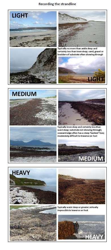
18 2.5.2 Strandline deposits Appendix 4 contains the description and guidance given to surveyors on how to assess strandline deposits of beach-cast seaweed. Counters were asked what extent of the count stretch (sector) was covered by heavy, medium and light deposits. Considering these dimensions, a score was calculated to summarise the relative amount of beach-cast seaweed available on the sector. Scores were first generated separately for the amounts of heavy, medium and light deposits and these then summed to provide an overall score for the sector (Table 2.5.i). For example, if 8% of the sector was covered with medium deposits of beach-cast seaweed and 2% by light deposits, the overall score would be (3+17.5). Table 2.5.i Scoring matrix for strandline deposits of beach-cast seaweed. The total score for a sector is the sum of the scores for heavy, medium and light deposit taken from this table. Strandline deposit description heavy medium light Extent of sector SCORES High (>5%) Medium-high (26-5%) Medium-low (11-25%) Low (1-1% of sector) None (<1%) 2.6 Comparison with Population Estimates Methodology for the Non-estuarine Coast from NEWS II Given the considerations described above, care must be taken when comparing data between surveys presented in the results below. Ultimately, estimates of population change will be made following a paired count stretch approach as used by Rehfisch et al. (23). This is a more powerful approach than that of direct comparison of estimates of total numbers between surveys, the latter being vulnerable to differences in geographical coverage between surveys or unknown biases in count-stretch selection. As described in Section 2.5.1, we have undertaken a revision of the allocation of count sectors to use more refined regions, especially in Scotland, Wales and Northern Ireland, and so had a more refined stratification available for analysis and so would expect improved abundance estimates for those region over what would have been reported previously. We also have a greater understanding of the synchrony/asynchrony of survey visits within regions, facilitated by online data capture, than previously. Accordingly, we have adjusted precise details of the analysis so we no longer treat the counted part of the coast within each region as a census to which an extrapolated estimate for the remainder is added, but rather treat the counts as sample repetitions to be extrapolated to the entire coast within that region. Furthermore, the exercise of loading data from past surveys into the on-line database resulted in some lost data being retrieved and there have been minor modifications in the assignment of stretches that are intermediary between estuarine and non-estuarine coast to include those not included in the WeBS Core Count scheme with a view to improving overall national population estimates. Accordingly, it has been desirable to reanalyse data from those previous surveys using the same analysis protocol as for the latest survey and so increase comparability. 16
19 3. RESULTS 3.1 Coverage Coverage for the UK was significantly improved on NEWS II, with 53% of the non-estuarine coast covered by length (53% by number of stretches and 79% of priority stretches, compared with 44% of all stretches and 61% of priority stretches for NEWS II). Coverage of 8% or higher was achieved in Somerset, the Isles of Scilly and Coll, none of which had been surveyed during NEWS II. There was also some coverage of Alderney, Guernsey and Herm in the Channel Islands, but there was no coverage on Jersey or Sark. Tiree was not surveyed during the 215/16 survey period, but an equivalent 213 survey of NEWS stretches was incorporated into the NEWS III dataset (Mitchell et al. 213). See Figure 3.1.i for an overview and Appendix 1 for detailed coverage figures by country and NEWS region. 3.2 Population Estimates The most numerous wader species recorded on the non-estuarine coast of the UK during NEWS III was Oystercatcher (total count 44,116; point estimate for the non-estuarine coast 69,95). Oystercatcher is followed by Curlew (24,735; 44,344), Turnstone (14,215; 25,988), Dunlin Calidris alpina (13,336; 19,415), Redshank Tringa totanus (11,267; 18,513), Golden Plover Pluvialis apricaria (1,978; 18,513), Lapwing Vanellus vanellus (1,613; 17,49), Ringed Plover Charadrius hiaticula (8,24; 16,23), Sanderling (8,93; 12,93), Purple Sandpiper (5,63; 1,184), Bar-tailed Godwit (3,325; 6,217), Knot Calidris canutus (2,332; 2,683) and Grey Plover Pluvialis squatarola (855; 1,12). Population estimates including 95% confidence intervals for these are given in Table 3.2.i for all coastal habitats combined (i.e. intertidal, seaward and landward) for the non-estuarine coast for the UK, its constituent countries, Great Britain and crown dependencies. A total of 1,87 Snipe Gallinago gallinago was recorded and an estimate of 4,848 is provided using the same methodology, but the species is considered to be underestimated due to low detection rates. Other waterbird and seabird species were also counted during NEWS III and estimates are presented in Table 3.2.i for those with a headcount of 9 or more and excluding Velvet Scoter Melanitta fusca (numbers for this species were concentrated too much for the analysis to be meaningful). The two most numerous bird species recorded were gulls: Herring Gull Larus argentatus, (total count 17,9; point estimate for the non-estuarine coast 159,782) and Black-headed Gull Larus ridibundus (5,572; 64,198). Other non-wader waterbirds and seabirds using the non-estuarine coast in large numbers in mid-winter include Common Gull Larus canus (31,871; 54,239), Wigeon Anas penelope (22,619; 44,6), Guillemot Uria aalge (15,576; 42,481), Shag Phalacrocorax aristotelis (13,68; 34,217) and Eider (11,736; 23,946). 3.3 Population Estimates for NEWS II and Earlier Surveys Table 3.3.i contains revised bootstrap-derived UK non-estuarine coast estimates for key waders from NEWS II using the revised methodology and geographic regions described in Section 2.5.1, compared with those published in Austin et al. (28) and NEWS III. The revised analysis increases the 26/7 estimates for NEWS II for Oystercatcher, Grey Plover, Lapwing, Dunlin, Bar-tailed Godwit, Curlew and Redshank, with other wader species having estimates that, although changed, have 95% confidence limits overlapping those previously published. Figures 3.3.i and 3.3.ii plot the all-habitat and intertidal-only key wader estimates using the analysis methodology described in Section for the wader species from all four surveys. It should be noted that these differ from previously published estimates, and do not, for example, make adjustments for the tendency in NEWS I for better coverage of count stretches with higher numbers of birds (see Section 2.2). Particularly for species that use non-intertidal habitats (Golden Plover, Lapwing and Curlew) the estimate in Figure 3.3.i for the 1984 Winter Shorebird Count is depressed, presumably due to relatively low inclusion of landward habitats, with the intertidal estimates being perhaps more comparable (Figure 3.3.ii). 17
20 Population estimates using the revised analysis methodology suggest that several wader species were present on the non-estuarine coast in smaller numbers in 215/16 compared with 26/7: Lapwing(-57%), Curlew (-31%), Redshank (-37%) and Turnstone (-32%) estimates were all lower for NEWS III than NEWS II with non-overlapping 95% confidence intervals (Table 3.3.i, Figure 3.3.i). The estimate for Sanderling increased (+79%). Of the remaining key wader species where the 95% confidence intervals for NEWS II and NEWS III overlapped, Bar-tailed Godwit (+53%), Dunlin (+13%) and Knot (+5%) increased and Golden Plover (-49%), Oystercatcher (-23%), Grey Plover (-21%), Ringed Plover (-13%) and Purple Sandpiper (-12%) decreased. 3.4 Distributions Figure 3.4.i indicates the centroids of species distributions recorded during NEWS III; whilst not adjusted for coverage, or including WeBS data, this allows for some comparison of distribution between species. The centroids were calculated by the weighted mean location, weighted by the abundance recorded on the count stretch (maximum count in cases where multiple visits were made). Shelduck, Knot, Sanderling and Dunlin are well distributed along the UK coastline, without a strong bias in any direction. Relatively few species have a southern bias; however, of the gulls only Common Gull has a northerly bias, the others occurring in greater numbers in southern Britain. Other species with a more south-easterly distribution include Cormorant Phalacrocorax carbo, Red-throated Diver Gavia stellata, Great Crested Grebe Podiceps cristatus and Dark-bellied Brent Goose Branta bernicla bernicla. Of the waders, Snipe, Bar-tailed Godwit and Purple Sandpiper have the most northerly non-estuarine coast distributions and Grey Plover the most southerly; Ringed Plover the most westerly and Grey Plover the most easterly distribution. UK maps of counts for individual species are given in Appendix 3. Many species, particularly waders, occur relatively equally on both the east and west coasts, such as Curlew, Redshank, Ringed Plover and Turnstone. Mallard Anas platyrhynchos, Teal Anas crecca and Goldeneye Bucephala clangula similarly show little tendency to favour one coast above the other. Bar-tailed Godwit favours Orkney and the Outer Hebrides; Purple Sandpiper also occurs in greatest numbers there, but also occurs frequently along the east coast of Scotland and north-eastern England, resulting in a mean location that is further east than that of Bar-tailed Godwit. The mean location for Fulmar Fulmarus glacialis and Gannet Morus bassanus was in the far north-east, but inspection of their maps shows clusters of records in other areas such as Cornwall. Exploratory methods can be used to identify areas with high density or diversity of species. Figure 3.4.ii identifies areas where many waders are present using spatial kernel density smoothing on the combined abundance of the 13 key wader species on each NEWS count stretch. It also identifies coastal stretches with seven or more of those species present. Although limited, as not adjusted for coverage, it highlights the potential importance of areas such as the north Kent coast, north-east England, Orkney, north Wales coast and Outer Ards in Northern Ireland. 3.5 NEWS Report Online: Regional Distribution and Estimates Detailed maps showing the recorded count and coverage for each species are published on the NEWS tab of the Wetland Bird Survey Report Online at The count symbol displayed is based on the maximum count in the case of multiple visits (unlike in the calculation of estimates, where the count made closest to the 17 th January 216, International Waterbird Count day, was used for each count stretch). The region maps indicate coverage per species, including partial habitat coverage where, for example, the intertidal habitat was covered but seaward and landward habitats were not for each sector, interpreted to how this affects the coverage for individual species. The region table gives the head count and regional estimate for each species present. In addition to data from the latest 18
21 survey, data on counts and coverage are also available from WSC, NEWS I and NEWS II to facilitate comparisons between surveys. 3.6 Designated Sites Some non-estuarine coastal SPAs and SSSIs have non-estuarine waders (Turnstone, Purple Sandpiper, Sanderling, Ringed Plover, Curlew, Bar-tailed Godwit) or Eider as notified interest features. Appendix 2a tabulates counts made during NEWS III at these key designated sites and also gives WeBS counts where these were made. To aid in interpretation, Appendix 2b gives the equivalent counts for WSC, NEWS I and NEWS II and information on coverage of the designated site in each survey (no extrapolation is made to account for incomplete coverage) and Appendix 2c shows the geographic location of the count stretches surveyed during NEWS III compared to the designated site boundary. It should be noted that double counting was possible during NEWS III as, in contrast to WeBS, it was not feasible to locally synchronise counting. 3.7 Strandline Deposits Figure 3.7.i illustrates estimates of the relative amounts of strandline deposits of beach-cast seaweed. Areas which were reported as having large amounts of strandline deposits included the east of Northern Ireland around the Ards peninsular, Anglesey in Wales, and the Solent, the Yorkshire coast around Flamborough Head, and the north Northumberland coast in England. In Scotland, coastlines reported as having high strandline deposits densities included those of Fife, Orkney, Shetland and much of west Scotland. 3.8 Data Collection and Collation Participants were encouraged to give feedback on their experience of taking part for consideration in future surveys. Feedback received included the following: Strandline and habitat recording There was some confusion over the difference between live seaweed cover and strandline seaweed deposits. Consider using live and dead seaweed to help distinguish. Confusion over recording where no deposits present; request for -1% rather than <1%. Request for woodland to be added as a landward habitat. Request for more guidance on profiles, especially regarding cliffs. Instructions and guidance Consider having two sets of instructions; one short (one page A4) and one more comprehensive. Consider having a more extensive FAQ and more photos to illustrate habitats. Clarify where e.g. Fulmar on cliffs should be recorded (i.e. in the intertidal zone). Request for more extensive guidance to Regional Organisers, including making it clear what their responsibilities are (i.e. checking data) and what to do if not happy with the count that has been submitted and they want to organise a recount. Online Data Entry There is more correspondence received when surveys are online, as it is easier for volunteers to make contact the organiser and ask questions; need to ensure this is properly resourced. Request for an option to say no birds and skip to the submit button after entering the habitat data. Consider using a more map-based procedure to select a count stretch (there are potential cost implications if, for example, OS maps are used). 19
22 Consider ways of ordering the count stretches so they are easier to find for data entry purposes for those surveying multiple count stretches and implement a way to view which sectors have been input. 2

23 Figure 3.1.i Coverage obtained for NEWS III. Coastal stretches in blue were covered; those in white were not covered. 21
24 Table 3.2.i The population estimates of the key species of waterbird and seabird on the non-estuarine coast of the UK and its constituent countries, Great Britain and crown dependencies during winter 215/16. Each population estimate is presented as the median bootstrapped value and its 95% confidence limits. Similar estimates for NEWS regions are given on the NEWS report online. Country coverage statistics are given in Appendix 2. Estimates for species that occur out to sea are for individuals visible from the coast only and strongly influenced by weather conditions. Snipe numbers are likely to underestimated due to low detection rates. Species in bold were the key waders reported in previous NEWS. Species Northern Ireland England Scotland Wales Isle of Man Channel Islands Great Britain United Kingdom Greylag Goose Anser anser 36 (2-126) 7 ( - 35) 13,991 (1,83-17,725) 5 ( - 25) ( - ) 8 ( - 48) 14,21 (1,97-17,875) 14,78 (1,11-17,9) Brent Goose (Dark-bellied) Branta bernicla bernicla ( - ) 1,967 (99-3,82) ( - ) 43 ( - 133) ( - ) 136 (2-358) 2,11 (1,119-3,842) 2,11 (1,119-3,842) Brent Goose (Light-bellied) Branta bernicla hrota 1,66 (471-2,317) 16 ( - 8) 143 (2-372) 265 (73-548) ( - ) ( - ) 456 ( ) 1,534 (82-2,92) Shelduck Tadorna tadorna 56 (23-98) 413 (61-1,194) 1,4 (97-2,9) 157 (56-337) 193 (7-411) 149 (8-662) 1,995 (1,272-2,846) 2,42 (1,338-2,916) Wigeon Anas penelope 14 ( - 59) 1,842 (44-4,6) 41,643 (34,12-49,854) 1,6 (61-1,763) 896 (8-3,288) ( - ) 44,589 (36,75-53,2) 44,6 (36,714-53,228) Teal Anas crecca 1,121 (462-2,223) 38 ( ) 8,545 (6,576-11,415) 128 (22-326) 99 ( - 495) 1 ( - 13) 9,17 (7,19-11,959) 1,329 (7,99-13,177) Mallard Anas platyrhynchos 47 ( ) 932 (523-1,489) 13,427 (11,139-15,284) 216 ( ) 32 (17-749) 17 (12-25) 14,663 (12,328-16,369) 15,98 (12,762-16,89) Eider Somateria mollissima 446 (261-74) 667 ( ) 22,762 (16,528-35,85) 19 (2-47) 151 (49-26) ( - ) 23,496 (17,196-36,547) 23,946 (17,64-37,183) Long-tailed Duck Clangula hyemalis 1 ( - 3) 24 ( - 74) 4,82 (3,333-7,66) ( - ) ( - ) ( - ) 4,832 (3,333-7,85) 4,834 (3,334-7,85) Common Scoter Melanitta nigra 1 ( - 8) 678 (395-1,39) 2,415 (923-4,756) 7,24 (1,876-19,67) ( - ) ( - ) 1,541 (4,499-22,17) 1,543 (4,5-22,111) Goldeneye Bucephala clangula 11 ( - 46) 76 (25-142) 2,38 (1,268-3,179) 11 (4-2) ( - ) ( - ) 2,129 (1,335-3,297) 2,136 (1,336-3,39) Red-breasted Merganser Mergus serrator 54 (17-9) 23 ( ) 7, (6,85-7,837) 177 (96-267) ( - ) ( - ) 7,389 (6,478-8,276) 7,424 (6,553-8,323) Red-throated Diver Gavia stellata 63 (35-123) 1,696 (495-4,915) 789 (68-952) 176 (19-34) 9 ( - 6) ( - ) 2,698 (1,447-5,827) 2,765 (1,54-5,98) Great Northern Diver Gavia immer 75 (41-18) 217 ( ) 4,65 (3,388-4,85) 54 (3-89) ( - ) 11 ( - 28) 4,326 (3,671-5,128) 4,398 (3,728-5,234) 22
25 Table 3.2.i continued Species Northern Ireland England Scotland Wales Isle of Man Channel Islands Great Britain United Kingdom Great Crested Grebe Podiceps cristatus 1 ( - 4) 5,498 (639-12,489) 16 (3-31) 198 ( ) ( - ) 14 ( - 29) 5,751 (898-12,696) 5,751 (9-12,697) Fulmar Fulmarus glacialis 848 (238-2,21) 4,224 (2,721-5,254) 6,55 (42,13-85,374) 66 (43-932) 52 ( - 146) 32 ( - 118) 65,182 (47,396-9,38) 66,39 (48,22-9,75) Gannet Morus bassanus 16 (6-26) 965 (39-2,785) 8,997 (35-43,333) 1 ( - 4) 4 ( - 21) 14 ( - 98) 9,983 (1,189-44,681) 9,994 (1,2-44,698) Cormorant Phalacrocorax carbo 889 (462-1,452) 6,79 (3,725-1,433) 7,735 (6,45-11,195) 75 ( ) 89 (19-167) 14 (46-239) 14,96 (1,693-2,588) 15,792 (11,863-21,288) Shag Phalacrocorax aristotelis 531 (43-696) 3,215 (2,91-5,1) 3,43 (24,657-38,197) 336 ( ) 122 (36-269) 357 (194-6) 33,823 (27,896-41,791) 34,217 (28,348-42,394) Grey Heron Ardea cinerea 139 (11-18) 229 ( ) 4,86 (4,45-5,442) 126 (85-158) 39 (9-97) 76 (22-134) 5,218 (4,733-5,778) 5,365 (4,834-5,932) Oystercatcher Haematopus ostralegus 3,63 (2,87-4,51) 11,639 (9,982-13,434) 43,576 (38,468-48,924) 1,957 (7,93-15,173) 1,3 (269-4,81) 2,613 (1,198-4,183) 66,439 (6,427-72,54) 69,95 (64,24-75,545) Ringed Plover Charadrius hiaticula 539 (29-768) 1,362 (846-2,128) 13,537 (1,872-16,19) 672 (49-929) 9 (1-288) 126 ( - 42) 15,647 (12,797-18,166) 16,23 (13,245-18,541) Golden Plover Pluvialis apricaria 2,446 (339-6,352) 1,529 (346-3,42) 12,339 (6,94-24,782) 876 (13-2,689) ( - ) ( - ) 15,259 (9,95-27,879) 18,513 (11,238-3,825) Grey Plover Pluvialis squatarola 28 (11-5) 512 ( ) 293 (17-498) 175 (44-353) 6 ( - 45) 8 ( - 1,98) 987 (644-1,458) 1,12 (675-1,481) Lapwing Vanellus vanellus 2,572 (1,93-4,66) 1,896 (478-5,297) 11,222 (7,862-14,365) 1,648 (573-2,975) ( - ) 14 ( - 294) 14,779 (11,925-19,968) 17,49 (14,148-22,178) Knot Calidris canutus 3 ( - 9) 7 (2-15) 1,565 (58-2,893) 1,78 (324-2,56) ( - ) ( - ) 2,674 (1,212-4,478) 2,683 (1,213-4,484) Sanderling Calidris alba 46 (3-1,635) 3,446 (2,454-4,632) 8,266 (5,153-11,999) 619 (18-1,53) 111 ( - 629) 14 ( - 119) 12,41 (9,489-16,78) 12,93 (1,248-17,268) Purple Sandpiper Calidris maritima 156 (58-279) 613 ( ) 9,47 (7,86-13,84) 43 (21-69) 6 ( - 32) ( - ) 1,28 (7,661-13,815) 1,184 (7,78-13,945) Dunlin Calidris alpina 1,395 (537-2,673) 3,457 (1,618-7,336) 12,36 (6,29-2,927) 1,951 (613-3,644) 4 ( - 32) 52 ( - 676) 18,48 (1,57-25,727) 19,415 (12,737-26,634) Snipe Gallinago gallinago 72 (2-125) 32 (1-136) 4,718 (3,972-5,62) 28 (6-7) 3 ( - 23) ( - ) 4,796 (4,39-5,674) 4,848 (4,97-5,769) Bar-tailed Godwit Limosa lapponica 26 (6-89) 118 (22-351) 5,984 (4,241-9,329) 11 (2-29) ( - ) 2 ( - 19) 6,192 (4,35-9,49) 6,217 (4,314-9,51) 23
26 Table 3.2.i continued Species Northern Ireland England Scotland Wales Isle of Man Channel Islands Great Britain United Kingdom Curlew Numenius arquata 1,839 (1,317-2,412) 3,9 (1,94-5,424) 36,578 (31,14-42,698) 2,769 (2,122-3,659) 1, ( - 3,84) 599 (151-1,282) 42,498 (36,476-48,961) 44,344 (38,324-5,613) Redshank Tringa totanus 1,392 (1,11-1,772) 2,171 (1,687-2,691) 13,694 (12,351-14,912) 1,185 (715-1,787) 99 (8-285) 58 ( - 191) 17,29 (15,688-18,31) 18,513 (17,122-19,758) Turnstone Arenaria interpres 1,518 (1,22-1,766) 3,513 (2,693-4,136) 2,31 (17,544-23,242) 1,54 (743-1,38) 16 (2-472) 138 (29-252) 24,553 (22,78-27,843) 25,988 (23,552-29,324) Kittiwake Rissa tridactyla 34 (27-1,244) 1,697 (458-4,726) 676 (386-1,55) 982 (111-2,836) 8 ( - 68) ( - ) 3,69 (1,681-6,54) 4,29 (2,141-7,447) Black-headed Gull Larus ridibundus 4,284 (2,874-6,117) 35,26 (28,11-44,711) 1,561 (7,928-14,511) 14,94 (8,97-25,549) 357 (77-96) 1,235 (597-2,474) 59,918 (49,5-74,177) 64,198 (53,243-8,86) Common Gull Larus canus 2,32 (1,46-4,21) 7,54 (4,894-1,846) 42,236 (34,248-51,485) 1,876 (1,145-2,53) 23 ( - 115) ( - ) 51,892 (43,681-6,61) 54,239 (45,544-61,989) Lesser Black-backed Gull Larus fuscus 27 (2-71) 1,322 (896-1,732) 392 ( ) 711 ( ) 2 ( - 14) 86 (6-255) 2,437 (1,96-2,98) 2,47 (1,944-2,928) Herring Gull Larus argentatus 5,141 (3,625-7,919) 59,33 (48,744-69,73) 67,813 (61,332-75,82) 26,67 (22,436-31,564) 3,255 (1,772-5,98) 6,633 (3,663-1,599) 154,218 (138, ,47) 159,782 (144, ,784) Great Black-backed Gull Larus marinus 621 (327-1,169) 6,977 (5,585-8,845) 11,694 (1,414-13,348) 922 (745-1,124) 64 (7-144) 1, (54-2,25) 19,64 (17,823-21,769) 2,333 (18,335-22,552) Guillemot Uria aalge 114 (4-271) 2,146 (1,15-3,841) 35,931 (3,79-1,44) 4,472 (83-12,194) ( - ) ( - ) 42,331 (8,77-111,615) 42,481 (8, ,665) Razorbill Alca torda 273 ( ) 562 (29-1,138) 1,328 (664-2,374) 148 (35-331) ( - ) 19 ( - 56) 2,19 (1,323-3,332) 2,396 (1,597-3,632) Black Guillemot Cepphus grylle 81 (49-131) 6 ( - 19) 3,452 (2,75-3,981) 12 ( - 25) ( - ) ( - ) 3,479 (2,751-4,15) 3,551 (2,83-4,82) 24
27 Table 3.3.i Population estimates of the key species of wader on the non-estuarine coast of the UK during winter 26/7 using the revised methodology, 26/7 estimates using the previous methodology (Austin et al. 28) and 215/16 estimates using the revised methodology. Each population estimate is supplied as the median bootstrapped value and its 95% confidence limits. ENGLISH NAME 26/7 (Austin 28) 26/7 215/16 Oystercatcher 71,14 (68,354-74,18) 9,74 (74,751-16,51) 69,95 (64,24-75,545) Ringed Plover 15,774 (14,74-16,92) 18,575 (14,225-27,397) 16,23 (13,245-18,541) Golden Plover 24,355 (22,248-29,77) 36,447 (23,57-55,367) 18,513 (11,238-3,825) Grey Plover 818 ( ) 1,284 (922 1,654) 1,12 (675 1,481) Lapwing 9,89 1 (8,96-11,19) 4,237 (28,54-52,352) 17,49 (14,148-22,178) Knot 2,176 (1,846-2,692) 2,547 (989 4,839) 2,683 (1,213-4,484) Sanderling 6,467 (5,722-7,489) 7,25 (5,185-9,911) 12,93 (1,248-17,268) Purple Sandpiper 11,329 (1,499-12,485) 11,527 (8,794-15,22) 1,184 (7,78-13,945) Dunlin 1,12 (8,91-11,487) 17,43 (12,715-25,715) 19,415 (12,737-26,634) Bar-tailed Godwit 1,596 (1,417-1,824) 4,66 (2,161-7,435) 6,217 (4,314-9,51) Curlew 46,243 (44,63-48,949) 64,681 (53,951-78,256) 44,344 (38,324-5,613) Redshank 24,263 (23,43-25,376) 29,184 (25,446-33,26) 18,513 (17,122-19,758) Turnstone 33,922 (32,488-35,244) 38,78 (33,48-42,452) 25,988 (23,552-29,324) 1 This estimate was identical to the intertidal estimate and likely an error, see discussion in
28 Figure 3.3.i All habitat population point estimates and 95% confidence intervals for key species of wader using the revised methodology for data from all four surveys. Values for previous surveys are not equivalent to those previously published and coverage biases and uncertainty in the first two surveys may adversely influence those estimates (especially WSC estimates of species that favour inland habitats). 26
29 Figure 3.3.i continued 27
30 Figure 3.3.ii Intertidal-only habitat population point estimates and 95% confidence intervals for key species of wader using the revised methodology for data from all four surveys 28
31 Figure 3.3.ii continued 29
32 Figure 3.4.i Species location centroids for NEWS III surveys. Where multiple counts were carried out at an individual count stretch, the maximum count for each species was used. 3

33 Figure 3.4.ii Non-estuarine coast with high density and diversity of key species of wader (i.e. Oystercatcher, Ringed Plover, Golden Plover, Grey Plover, Lapwing, Knot, Sanderling, Purple Sandpiper, Dunlin, Bar-tailed Godwit, Curlew, Redshank, and Turnstone). 31
.")
34 Figure 3.7.i Inventory of strandline deposits of beach-cast seaweed for the UK and Republic of Ireland. Strandline deposits score calculated by the extent of heavy, medium and light deposits present (Table 2.5.i). Kernal density map of scores shown as inset. 32
35 4. DISCUSSION 4.1 Population Estimates The purpose of this report was to estimate the number of waders present on the non-estuarine coast of the UK during the winter of 215/16, revising the previous estimates in Austin and Rehfisch (27), and for the first time in reporting a non-estuarine coast survey to include estimates of other waterbirds and seabirds present. Estimates were produced using data for the earlier surveys as well as the most recent survey and those for NEWS II are included here. The revised methodology, following a better understanding of the degree of asynchrony of counts, which treats counts as a sample within geographical regions, rather than a census to be extrapolated, led to changes in some cases for the 26/7 wader estimates (Table 3.3.i). In all species, the revision increased the population estimate. For some species, the change was more notable in the confidence interval rather than the point estimate; for example, the Purple Sandpiper point estimate only increased slightly from 11,329 to 11,527 but the 95% confidence interval was three times wider, changing from (1,499-12,485) to (8,794 15,22). This is to be expected, as the confidence intervals previously assumed the counts that were made were a census, with no uncertainty, rather than an estimate, with associated uncertainty. There were also large changes in the estimates for other species, either in absolute or percentage terms compared to the published estimate for NEWS II; for example, the estimate for Oystercatcher increased from 71,14 to 9,74 and the estimate for Bar-tailed Godwit from 1,596 to 4,66. The biggest apparent adjustment to the previously published estimates is for Lapwing, for which the 26/7 point estimate increased from 9,89 to 4,237, with the 95% interval changing from (8,96-11,19) to (28,54-52,352). However, this is because of an error in Austin and Rehfisch (27) where the reported all-habitat estimate given for Lapwing was actually that for the intertidal habitat only. Comparing the intertidal-only estimates (Figure 3.3.ii), the estimate using the revised methodology is 11,461 with a 95% confidence interval of (7,828 16,41), which intersects that of Austin and Rehfisch (27). This issue only affected Lapwing. All calculated regional estimates are included on NEWS Report Online, including those for species such as Velvet Scoter for which national estimates are not included in Table 3.2.i due to their restricted distributions or recorded count not meeting the threshold. The non-estuarine coast estimates from this report will input into the next UK wintering waterbird population estimates assessment. 4.2 Species Distribution along the Non-estuarine Coast The Online NEWS Report allows detailed inspection of NEWS counts on interactive maps at a regional level. Particularly useful is sector coverage information when interpreting data at a site level (since missing landward or seaward counts on a sector are negligible for some species but not for others). Local research and site casework using the Online NEWS report or raw count data is encouraged, particularly as, with the benefit of local knowledge, stronger assumptions can often be made for particular areas when analysing the data from NEWS. Figure 3.4.i illustrated the mean location (weighted by count) for each species for which estimates were produced, with species maps in Appendix 3. The mean location for all species was slightly to the south-east of the mean location of a counted NEWS sector, being strongly influenced by the distribution of the most numerous species, Herring Gull, Black-headed Gull and Oystercatcher; whereas most species have their individual mean location north of the mean location of a counted NEWS sector. 33
36 The relative importance of the Scottish non-estuarine coast is demonstrated by 31 of the 43 species in Figure 3.4.i having their mean weighted location within Scotland. The distribution information from NEWS III will be valuable for future research into how the distributions of non-estuarine waterbirds change over time, for example in response to climate change. Areas such as Orkney, the outer Forth Estuary, Anglesey, the Uists and the Outer Ards have both high amounts of strandline deposits recorded (Figure 3.6.i) and high wader density and diversity (Figure 3.4.ii). Relationships between coastal bird communities and strandline deposits will be explored in planned further work to investigate the extent to which the amount of seaweed deposited can predict the overall abundance and distribution of coastal wintering waterbird populations. Such information will provide an insight into those areas likely to be most impacted by any large-scale human-induced changes in the availability of seaweed and the likely risks posed to key waterbird populations. Mammal data collected as part of the survey will be made available for use under an Open Government Licence via the National Biodiversity Network (NBN) Atlas ( 4.3 Indications of Change for Key Wader Species The latest WeBS ten-year trends for the UK for the key wader species all show declines, apart from Bartailed Godwit and Sanderling (Frost et al. 217). Over a similar time period, the NEWS III estimate also increased for these two species compared with NEWS II: in the case of Sanderling (+79%) there was no overlap in the confidence intervals, suggesting a real increase in overwintering numbers in 215/16 compared with 26/7; but for Bar-tailed Godwit (+53%) the 95% confidence intervals from the two surveys did overlap. Population estimates for Dunlin (+14%), Knot (+5%), Purple Sandpiper (-12%), Ringed Plover (-13%), Grey Plover (-21%) and Oystercatcher (-23%) also all had confidence intervals that overlapped with those in NEWS II, indicating further paired-sample analysis is needed to properly understand whether and where change has occurred. For five species, non-overlapping 95% confidence intervals suggest genuine declines since 26/7, and comparison with WeBS trends suggest a possibility that the magnitude of the declines over this period may possibly be greater than on WeBS sites. These species were Lapwing (change from NEWS II to NEWS III estimate -57%), Golden Plover (-49%), Redshank (-37%), Turnstone (-32%) and Curlew (-31%). Compared to all three previous surveys, for the key wader species on the intertidal habitat (Figure 3.3.ii) the 95% confidence intervals for NEWS III overlapped with at least one previous survey for all the species except Turnstone, with the NEWS III intertidal point estimate being 24,381, lower than WSC (36,21), NEWS I (33,994) and NEWS II (32,68). The change between the intertidal-only estimate for WSC in 1984/85 and NEWS III in 215/16 is -33% and from NEWS II in 26/7 it is -25%. In comparison, the WeBS 25-year trend for Turnstone is -47% and 1-year trend -24% (Frost et al. 217). Overlapping population estimate confidence intervals do not necessarily mean we will be unable to show there has been change in non-estuarine coast populations using more robust paired-sample comparisons. Although Figures 3.3.i and 3.3.ii may give some indication of directions of population change, it should also be remembered that the uncertainty in habitat coverage in the Winter Shorebird Count, and the bias towards coastlines with more birds present in the first Non-estuarine Waterbird Survey, means caution should be used in interpreting results from the earlier surveys. It is therefore envisaged that further analyses will be undertaken to estimate more rigorously how numbers may have changed between years. 34
37 Acknowledgements We would like to thank the organisers and counters who contributed their time to this survey and without whom the survey would not have been possible. The Wetland Bird Survey allowed the WeBS counter network to be used for this survey and this was supplemented by the BTO s Regional Network. Many staff from the funding organisations also became involved with the fieldwork in a voluntary capacity. David Jarrett, David Norfolk, Mark Eaton, the Rye Meads Ringing Group, the Wash Wader Ringing Group and RAF Ornithological Society helped survey in remote regions which otherwise would have had low coverage. Neil Calbrade assisted with organisation and database management and Liz Humphreys, Ron Summers, Niall Burton, Karen Wright, Andy Musgrove, John Calladine, Ben Darvill, David Jarrett and Chris Wernham advised on survey design, organisation or analysis. The NEWS Online recording system and the Online NEWS Report were developed by Dave Turvey, Matthew Baxter, Stephen Pritchard and Mark Hammond. We are particularly grateful to the Local Organisers: Carole Bainbridge; Ian Bainbridge; Jim Baldwin; Malcolm Balmer; Yvonne Benting; Dave Boddington; John Bowler; Jim Cassels; John Clark; Simon Cohen; Martin Cook; Colin Corse; Helen Crabtree; Andrew Craggs; Patrick Cullen; Jim Dustow; John Dye; Norman Elkins; Philip Espin; Kathy Evans; Dave Grant; Stephen Groves; Sarah Harris; Paul Harvey; Annie Haycock; Mark Holling; Ian Hopkins; Chris Hudson; Lyndon Jeffery; Daniel Jenkins-Jones; Ben Jones; Kelvin Jones; Russell Jones; Kerry Leonard; Sinclair Manson; Frank Mawby; Norman McCanch; Adam McClure; Steve Morgan; Chris Mourant; Brian O'Leary; Geoffrey Orton; Rhion Pritchard; Peter Reay; Andy Riches; Peter Roseveare; Alison Searl; Chris Sharp; John Shillitoe; Ian Sims; Moray Souter; David Sowerbutts; Bob Swann; Eve Tigwell; Shane Wolsey; David Wood; and Mick Wright. We would also like to thank Matthew Murphy, Allan Drewitt, Simon Cohen, Neil McCulloch and Shane Wolsey for pursuing funding opportunities, and to Chas Holt who originally developed the NEWS III project. Matthew Murphy, Allan Drewitt, Colette Hall and David Stroud provided valuable comments on the report. NEWS III was supported financially by Scottish Natural Heritage, Natural England, Natural Resources Wales, the Department of Agriculture, Environment and Rural Affairs, Northern Ireland, the Wetland Bird Survey (a partnership between the British Trust for Ornithology, the Royal Society for the Protection of Birds and the Joint Nature Conservation Committee in association with the Wildfowl and Wetlands Trust) and the Irish Wetland Bird Survey (a joint project of BirdWatch Ireland and the National Parks and Wildlife Service). 35
38 36
39 References Austin, G. & Rehfisch, M.M. (25). Shifting non-breeding distributions of migratory fauna in relation to climatic change. Global Change Biology, 11, Austin G.E. & Rehfisch, M.M. (27). 27 Non-estuarine Coastal Waterbird Survey II: End of survey report. BTO, The Nunnery, Thetford, Norfolk IP24 2PU Austin, G. Collier, M. & Rehfisch, M.M. (28). Non Estuarine Coastal Waterbird Survey: Population Estimates and Broad Comparisons with Previous Surveys. BTO Research Report 51. Buck, A.L. (1997) An Inventory of UK Estuaries. 7 vols. JNCC, Peterborough. Frost, T.M., Austin, G.E., Calbrade, N.A., Hall, C., Mellan, H.J., Hearn, R.D., Stroud, D.A., Wotton, S.R. & Balmer, D.E. (217).Waterbirds in the UK 215/16: The Wetland Bird Survey. BTO, RSPB and JNCC, in association with WWT. British Trust for Ornithology, Thetford. Lehikoinen, A., Jaatinen, K., Vahatalo, A., Clausen, P., Crowe, O., Deceuninck, B., Hearn, R., Holt, C.A., Hornman, M., Keller, V., Nilsson, L., Langendoen, T., Wahl, J. & Fox, A.D. (213). Rapid climate driven shifts in wintering distributions of three common waterbird species. Global Change Biology, 19, Mitchell, C., Bowler, J., Boles, Y., Broad,R., Dickson,J., Green, M., Jones, B. & Robinson, A. (213). Wintering wader survey on the Isle of Tiree, Argyll, February 213. Unpublished report to Scottish Natural Heritage. Maclean, I.M.D., Austin, G.E., Rehfisch, M.M., Blew, J., Crowe, O., Delany, S., Devos, K., Deceuninck, B., Günther, K., Laursen, K., van Roomen, M. & Wahl, J. (28). Climate change causes rapid changes in the distribution and site abundance of birds in winter Global Change Biology, 14, (doi:1.1111/j x) Moser, M.E. (1987). A revision of population estimates for waders (Charadrii) wintering on the coastline of Britain. Biological Conservation 39, Rehfisch, M.M., Holloway, S.J. & Austin, G.E. (23). Population estimates of waders on the non-estuarine coasts of the UK and the Isle of Man during the winter of Bird Study, 5, Rehfisch, M.M., Austin, G.E., Freeman, S.N., Armitage, M.J.S. & Burton, N.H.K. (24). The possible impact of climate change on the future distributions and numbers of waders on Britain s non-estuarine coast. Ibis, 146, S7-S81. 37
40 38
41 Appendix 1 Region Regional coverage for NEWS III. Values given indicate the total length of non-estuarine coast, total and percentage length of non-estuarine coast covered, number and percentage of all count stretches visited, and number and percentage of priority count stretches visited. These are maximum values based on coverage of the intertidal habitat only, coverage of inland and sea habitats generally being less than this. Data were derived from the NEWS count stretch definitions GIS coverage, which is based on the low-tide Watsonian County Boundary data obtained from the NBN Total length (km) Length covered (km) Percent length coverage Count stretches covered Priority stretches covered Causeway Coast and Glens % 52/66 83% 48/58 Mid and East Antrim % 37/43 9% 18/2 Newry Mourne and Down % 62/74 1% 2/2 Ards and North Down % 62/64 93% 28/3 Northern Ireland % 213/247 89% 114/128 Lothian and Borders % 51/55 92% 36/39 Fife % 43/43 1% 11/11 Angus % 35/35 1% 2/2 Aberdeenshire % 134/135 1% 48/48 Moray and East Ross % 61/64 98% 39/4 Shetland % 364/ % 195/332 Orkney % 319/494 85% 47/55 Sutherland and Caithness % 246/34 84% 127/151 West Ross % 111/285 66% 85/128 Inner Hebrides - north % 99/325 5% 81/162 Outer Hebrides % 121/244 84% 7/83 Lochaber % 73/33 82% 69/84 Argyll and Bute % 21/743 69% 129/186 Inner Hebrides - mid % 359/464 81% 57/7 Inner Hebrides - south % 92/221 88% 44/5 North Ayrshire and Arran % 55/15 65% 35/54 South Ayrshire % 3/48 69% 25/36 Dumfries and Galloway % 17/119 96% 48/5 Scotland % 251/ % 1166/1599 Conwy, Denbeigh and Flint % 29/29 1% 24/24 Anglesey % 19/19 1% 4/4 Gwynedd % 17/117 1% 72/72 Ceredigion % 38/52 85% 17/2 Pembroke and Carmarthen % 119/132 1% 3/3 Glamorgan % 94/96 1% 3/3 Wales % 496/535 99% 213/216 Somerset % 22/26 8% 16/2 Devon % 122/231 92% 6/65 Cornwall % 93/242 82% 41/5. 39
42 Region Total length (km) Length covered (km) Percent length coverage Count stretches covered Priority stretches covered Isles of Scilly % 35/46 76% 35/46 Dorset % 63/76 9% 27/3 Hampshire % 19/19 1% 14/14 Isle of Wight % 56/79 78% 47/6 West Sussex % 16/16 1% 1/1 East Sussex % 29/29 1% 1/1 Kent % 53/55 94% 34/36 Essex % 1/1 1% 1/1 Suffolk % 29/35 9% 18/2 Norfolk % 36/36 1% 3/3 Lincolnshire % 8/8 1% 8/8 East Yorkshire % 26/3 96% 25/26 North Yorkshire % 27/45 8% 24/3 Tees Valley % 22/22 1% 18/18 Durham % 12/12 1% 1/1 Tyne and Wear % 28/33 95% 19/2 Northumberland % 74/75 97% 38/39 Cumbria % 37/39 9% 18/2 England % 817/1164 Isle of Man % 16/63 Channel Islands % 16/63 Great Britain % 3814/7258 United Kingdom % 459/7631 9% 512/572 55% 11/2 56% 14/25 79% 1891/ % 23/256 4
43 Research Report No: Appendix 2a NEWS III counts for key designated sites. The head count is the sum of maximum sector counts for key species of interest during NEWS III of stretches intersecting key Special Protection Areas and Sites of Special Scientific Interest. The number of individuals of the interest feature cited in each site notification is given where appropriate, or N where a number is not given but the species was noted as being a qualifying feature or present in nationally important numbers. Grey shading and bold text indicates that the species is an interest feature at the site. Note that many of the designated sites include areas of non-open coast that were not included in the NEWS survey, and detailed analysis at the site level should combine NEWS data with other data sources. The maximum winter 215/16 WeBS count for the best match to the SPA or SSSI boundary is given where this is available (otherwise n/c ); this may or may not overlap with areas counted for NEWS III depending on the site. The regional estimate for the appropriate NEWS region is also given, with the 95% confidence intervals given in parentheses. Other regional estimates can be found in the NEWS report online at in the NEWS tab. Turnstone Purple Sandpiper Sanderling Ringed Plover Curlew Bar-tailed Godwit East Sanday Coast SPA interest feature N NEWS head count WeBS winter max (215/16) n/c n/c n/c n/c n/c n/c n/c Eider Orkney regional estimate 4,475 (3,534-5,471) 4,167 (2,552-6,37) 1,51 (633-3,121) 2,64 (1,448-2,577) 13,834 (1,363-18,246) 2,641 (1,371-4,862) 1,181 (821-1,685) Firth of Forth SPA interest feature NEWS head count WeBS winter max (215/16) 498 (NOV) 72 (NOV) 317 (MAR) 338 (DEC) 3574 (FEB) 111 (JAN) 559 (JAN) Lothian and Borders regional estimate (NB also partly in Fife) 165 (73-289) 33 (4-87) ( - ) 43 (7-11) 351 ( ) 6 ( - 3) 1,869 (499-4,322) Lindisfarne SPA interest feature NEWS head count
44 Research Report No Turnstone Purple Sandpiper Sanderling Ringed Plover Curlew Bar-tailed Godwit WeBS winter max (215/16) (132) (MAR) [165] (FEB) 96 (NOV) 1547 (DEC) [1159] (FEB) 532 (DEC) Northumberland regional estimate 646 ( ) 384 (17-8) 666 (364-1,75) 135 (39-39) North Uist Machair and Islands SPA interest feature 67 N (178-3,83) 115 (15-343) Eider 56 ( ) NEWS head count WeBS winter max (215/16) 13 (MAR) 38 (JAN) 19 (JAN) 144 (FEB) 55 (JAN) 7 (JAN) Outer Hebrides regional estimate 3,38 (2,5-5,13) Northumbria Coast SPA interest feature ,976 (1,342-5,675) 4,834 (2,514-8,95) 3,27 (1,954-4,938) 1,933 (1,391-2,746) 2,593 (1,276-5,791) 762 (32-1,548) NEWS head count WeBS winter max (215/16) Northumberland regional estimate (NB also partly in Tyne & Wear and Durham) 87 (NOV) 646 ( ) 39 (JAN) 384 (17-8) 538 (JAN) 666 (364-1,75) 142 (NOV) 135 (39-39) Outer Ards SPA interest feature (894) (MAR) 767 (178-3,83) 85 (JAN) 115 (15-343) 436 (NOV) 56 ( ) NEWS head count WeBS winter max (215/16) 619 (JAN) 32 (NOV) 1 (JAN) 226 (NOV) 65 (JAN) 5 (NOV) 663 (NOV) Ards and North Down Estimate 592 ( ) 58 (2-94) ( - ) 154 (41-29) 1,18 (59-1,45) 2 ( - 5) 255 (93-57)
45 Research Report No Turnstone Purple Sandpiper Sanderling Ringed Plover Sléibhtean agus Cladach Thiriodh (Tiree Wetlands and Coast) SPA interest feature Curlew Bar-tailed Godwit NEWS head count WeBS winter max (215/16) 25 (DEC) 28 (DEC) 75 (DEC) 15 (NOV) Inner Hebrides - mid regional estimate 1,175 (769-1,824) 31 (13-549) 795 (148-1,587) 1,245 (77-1,969) Solent and Southampton Water SPA interest feature 552 1,451 (985-1,94) 91 (44-218) Eider 435 ( ) NEWS head count WeBS winter max (215/16) 456 (JAN) (1) (NOV) 3 (JAN) 358 (DEC) 98 (JAN) 15 (JAN) 38 (MAR) Isle of Wight regional estimate (partly in Hampshire) 13 (27-224) 3 ( - 75) 278 ( - 992) 39 (5-117) South Uist Machair and Lochs SPA interest feature (51-215) ( - ) ( - ) NEWS head count WeBS winter max (215/16) 15 (NOV) 36 (NOV) 3 (DEC) 92 (FEB) (24) (FEB) Outer Hebrides regional estimate 3,38 (2,5-5,13) 2,976 (1,342-5,675) 4,834 (2,514-8,95) 3,27 (1,954-4,938) 1,933 (1,391-2,746) 2,593 (1,276-5,791) 762 (32-1,548) Thanet Coast and Sandwich Bay SPA interest feature 94 NEWS head count
46 Research Report No Turnstone Purple Sandpiper Sanderling Ringed Plover Curlew Bar-tailed Godwit WeBS winter max (215/16) 67 (DEC) 1 (MAR) 188 (JAN) 57 (NOV) 37 (DEC) 27 (JAN) 4 (MAR) Kent regional estimate 467 ( ) 8 (1-21) Isle of May SSSI interest feature N N 193 (58-44) 166 (57-342) 154 (8-259) NEWS head count WeBS winter max (215/16) n/a n/a Fife Estimate 148 (62-268) 83 (27-158) 1 ( - 3) 68 (23-127) 333 (26-57) ( - ) 2 ( - 5) Eider 3 ( - 6) 455 ( ) Rosehearty to Fraserburgh Coast SSSI interest feature 5 25 N N NEWS head count WeBS winter max (215/16) 75 (NOV) 16 (MAR) 23 (NOV) 121 (JAN) 3 (JAN) 45 (DEC) Aberdeenshire Estimate 411 ( ) 176 (84-48) Whiting Ness- Ethie Haven SSSI interest feature N N 213 (7-44) 79 (11-146) 2,48 (1,78-2,951) 19 (2-4) 1,373 (839-2,74) NEWS head count WeBS winter max (215/16) n/c n/c Angus Estimate 15 (32-29) 3 (2-61) 5 (3-16) 45 (9-99) 85 (53-12) 4 ( - 12) 46 (67-1,189)
47 45 Appendix 2b Winter Shorebird Count (WSC) and Non-estuarine Waterbird Survey (NEWS) I, II and III counts for key designated sites. The head count is the sum of maximum sector counts for key species of interest during each survey of stretches intersecting key Special Protection Areas and Sites of Special Scientific Interest. Bold text indicates that the species is an interest feature at the site. Coverage is shown for each survey as the number of stretches covered of all or some of the relevant habitats (landward, intertidal and seaward) compared with the total number of stretches intersecting with the designated site, with colour indicating the habitat-species groups. No extrapolation is undertaken to account for incomplete coverage. Winter Shorebird Count/Non-Estuarine Waterbird Survey head count Turnstone (TT) Purple Sandpiper (PS) Sanderling (SS) Ringed Plover (RP) Curlew (CU) Bartailed Godwit (BA) Eider (E_) Relevant habitats covered (# stretches) TT/PS/SS RP/CU/BA E_ All All Some All Some Total East Sanday Coast East Sanday Coast Firth of Forth Firth of Forth Lindisfarne Lindisfarne North Uist Machair and Islands North Uist Machair and Islands
48 46 Winter Shorebird Count/Non-Estuarine Waterbird Survey head count Turnstone (TT) Purple Sandpiper (PS) Sanderling (SS) Ringed Plover (RP) Curlew (CU) Bartailed Godwit (BA) Eider (E_) Relevant habitats covered (# stretches) TT/PS/SS RP/CU/BA E_ All All Some All Some Total Northumbria Coast Northumbria Coast Outer Ards Outer Ards Sléibhtean agus Cladach Thiriodh (Tiree Wetlands and Coast) Tiree Wetlands and Coast Solent and Southampton Water Solent and Southampton Water South Uist Machair and Lochs South Uist Machair and Lochs
49 47 Winter Shorebird Count/Non-Estuarine Waterbird Survey head count Turnstone (TT) Purple Sandpiper (PS) Sanderling (SS) Ringed Plover (RP) Curlew (CU) Bartailed Godwit (BA) Eider (E_) Relevant habitats covered (# stretches) TT/PS/SS RP/CU/BA E_ All All Some All Some Total Thanet Coast and Sandwich Bay Thanet Coast and Sandwich Bay Rosehearty to Fraserburgh Coast SSSI Rosehearty to Fraserburgh Coast Whiting Ness - Ethie Haven SSSI Whiting Ness- Ethie Haven Isle of May SSSI Isle of May
 and coverage during NEWS III")
50 48 Appendix 2c NEWS III stretches intersecting (orange) with designated site boundaries (grey) and coverage during NEWS III (green).
51 49
52 5
53 51 Appendix 3 NEWS III raw count distribution maps. Detail and coverage can be seen on the interactive regional maps at
54 52
55 53
56 54
57 55
58 56
59 57
60 58
61 59
62 6
63 61
64 62
65 63
66 64
67 65
68 66

69 Appendix 4 Instructions for counters taking part in NEWS III, including guidance on recording strandline deposits. 67
70 68
71 69
The Effects on Waterbirds of Dredging at the Cardiff Bay Barrage Report for 2005/06
 The Effects on Waterbirds of Dredging at the Cardiff Bay Barrage Report for 2005/06 Authors N.H.K. Burton & S.J. Holloway Report of work carried out by The British Trust for Ornithology under contract
Analysis of sea-watching data from Holme Bird Observatory, Norfolk
 Analysis of sea-watching data from Holme Bird Observatory, Norfolk BTO Authors Aonghais S.C.P. Cook, Chris Thaxter, Lucy J. Wright, Nick J. Moran, Niall H.K. Burton, Jed Andrews, Sophie Barker and Fred
Dispersed Waterbirds Survey
 Dispersed Waterbirds Survey Title Dispersed Waterbird Survey 2002/03 Description and Summary of Results The main wetland sites are counted by the Wetland Bird Survey (WeBS) Core Counts -- monthly counts
Skogsøy Spring Migration. Preliminary Results. Julian Bell
 Skogsøy 26 Spring Migration Preliminary Results Julian Bell 26 1 1. Introduction...4 2. Species Accounts...5 Red-throated Diver Gavia stellata...6 Black-throated Diver Gavia arctica...7 Great Northern
The UK Wintering Waterbird Indicator: New developments towards a more comprehensive assessment of trends in the wintering waterbird assemblage
 The UK Wintering Waterbird Indicator: New developments towards a more comprehensive assessment of trends in the wintering waterbird assemblage Authors G. E. Austin, A. N. Banks & M. M. Rehfisch A report
BROADMEADOW RIVER ESTUARY (SWORDS/MALAHIDE), CO. DUBLIN
, CO. DUBLIN") BROADMEADOW RIVER ESTUARY (SWORDS/MALAHIDE), CO. DUBLIN WATERBIRDS IN JULY AND AUGUST 2008 (with additional counts from 2004-2008) Oscar J. Merne, M.Sc. Ornithologist & Environmental Scientist August 2008
BROADMEADOW RIVER ESTUARY (SWORDS/MALAHIDE), CO. DUBLIN WATERBIRDS IN JULY AND AUGUST 2008 (with additional counts from 2004-2008) Oscar J. Merne, M.Sc. Ornithologist & Environmental Scientist August 2008
4.18 HAMFORD WATER. LTC site code:
 4.18 HAMFORD WATER LTC site code: BH Centre grid: TM2325 JNCC estuarine review site: 110 Habitat zonation: 367 ha intertidal, 106 ha subtidal, 58 ha nontidal Statutory status: Hamford Water SPA (UK9009131),
4.20 BLACKWATER ESTUARY
 4.20 BLACKWATER ESTUARY LTC site code: CB Centre grid: TL9507 JNCC estuarine review site: 112 Habitat zonation: 2368 ha intertidal, 1587 ha subtidal, 766 ha nontidal Statutory status: Blackwater Estuary
Urban Breeding Gull Surveys: A Survey Design Simulation
 Urban Breeding Gull Surveys: A Survey Design Simulation Authors Chris B. Thaxter, Cat Horswill, Kathryn E. Ross, Graham E. Austin, Dawn E. Balmer and Niall H.K. Burton Report of work carried out by the
OFFICE OF ENVIRONMENTAL SUSTAINABILITY
 This report has been cleared for submission by David Flynn. Eve O'Sullivan, 13/03/2018 10:52 OFFICE OF ENVIRONMENTAL SUSTAINABILITY ENVIRONMENTAL LICENSING PROGRAMME TO: Eimear Cotter, Director FROM: Brian
Cabra, Dublin 7. Appropriate assessment (screening) Report prepared for Crekav Trading GP Limited. November 2017
 Report prepared for Crekav Trading GP Limited. November 2017") Proposed development at Former CIE Lands, Carnlough Road, Cabra, Dublin 7 Appropriate assessment (screening) Report prepared for Crekav Trading GP Limited November 2017 Roger Goodwillie & Associates, Lavistown
Proposed development at Former CIE Lands, Carnlough Road, Cabra, Dublin 7 Appropriate assessment (screening) Report prepared for Crekav Trading GP Limited November 2017 Roger Goodwillie & Associates, Lavistown
The Effect of the Cardiff Bay Barrage on Waterbird Populations Final Report
 The Effect of the Cardiff Bay Barrage on Waterbird Populations Final Report Authors N.H.K. Burton, M.M. Rehfisch & N.A. Clark Report of work carried out by The British Trust for Ornithology under contract
National Parks and Wildlife Service
 National Parks and Wildlife Service Conservation Objectives Series Wexford Harbour and Slobs SPA 004076 Page 1 of 39 National Parks and Wildlife Service, Department of Arts, Heritage and the Gaeltacht,
Castlemaine Harbour Special Protection Area. (Site Code 4029) Version 2. Conservation Objectives Supporting Document
 Version 2. Conservation Objectives Supporting Document") Castlemaine Harbour Special Protection Area (Site Code 4029) Version 2 Conservation Objectives Supporting Document National Parks & Wildlife Service March 2011 T A B L E O F C O N T E N T S PART ONE -
Castlemaine Harbour Special Protection Area (Site Code 4029) Version 2 Conservation Objectives Supporting Document National Parks & Wildlife Service March 2011 T A B L E O F C O N T E N T S PART ONE -
THE PROPOSED DUBLIN ARRAY WIND FARM ASSESSMENT OF POTENTIAL IMPACTS ON SEABIRDS
 THE PROPOSED DUBLIN ARRAY WIND FARM ASSESSMENT OF POTENTIAL IMPACTS ON SEABIRDS Information in support of the Appropriate Assessment of the proposed Wind Farm Report for: Prepared by: February 2013. THE
The Effect of the Cardiff Bay Barrage on Waterbird Populations 12. Distribution and Movement Studies August 2000-May 2001
 The Effect of the Cardiff Bay Barrage on Waterbird Populations 12. Distribution and Movement Studies August 2000-May 2001 Authors N.H.K. Burton, M.M. Rehfisch & N.A. Clark Report of work carried out by
WWT/JNCC/SNH Goose & Swan Monitoring Programme survey results 2005/06
 1. Abundance WWT/JNCC/SNH Goose & Swan Monitoring Programme survey results 2005/06 Whooper swan Cygnus cygnus The fifth international census of Whooper Swans wintering in Britain, Ireland and Iceland was
WeBS Alerts 1998/99: Changes in numbers of wintering waterbirds in the United Kingdom at national, country and Special Protection Area (SPA) scales
 scales") WeBS s 1998/99: Changes in numbers of wintering waterbirds in the United Kingdom at national, country and Special Protection Area (SPA) scales Authors Philip W. Atkinson, Graham E. Austin, Niall H.K. Burton,
WeBS s 1998/99: Changes in numbers of wintering waterbirds in the United Kingdom at national, country and Special Protection Area (SPA) scales Authors Philip W. Atkinson, Graham E. Austin, Niall H.K. Burton,
Review and analysis of changes in waterbird use of the Mersey Estuary SPA, Mersey Narrows & North Wirral Foreshore pspa and Ribble & Alt Estuaries SPA
 Natural England Commissioned Report NECR173 Review and analysis of changes in waterbird use of the Mersey Estuary SPA, Mersey Narrows & North Wirral Foreshore pspa and Ribble & Alt Estuaries SPA First
Winter Atlas 1981/ /84
 Winter Atlas 1981/82-1983/84 Title Atlas of Wintering Birds in Britain and Ireland: 1981/82-1983/84. Description and Summary of Results The publication of The Atlas of Breeding Birds in Britain and Ireland
WeBS Alerts 1999/2000: Changes in Numbers of Wintering Waterbirds in the United Kingdom at National, Country and SSSI Scales
 WeBS Alerts 1999/2000: Changes in Numbers of Wintering Waterbirds in the United Kingdom at National, Country and SSSI Scales Interim Report Authors Philip W. Atkinson, Mark M. Rehfisch & Mark Pollitt Data
Malahide Estuary Special Protection Area. Conservation Objectives Supporting Document
 Malahide Estuary Special Protection Area (Site Code 4025) Conservation Objectives Supporting Document VERSION 1 National Parks & Wildlife Service August 2013 SUMMARY T A B L E O F C O N T E N T S PART
Little Ringed Plover 2007
 Little Ringed Plover 2007 Title Breeding Plover Survey 2007 (Little Ringed Plover) (Note: In the breeding season of 2007, the BTO ran a UK-wide survey covering both Little Ringed Charadrius dubius and
STOUR ESTUARY Essex, Suffolk
 STOUR ESTUARY Essex, Suffolk Internationally important: Nationally important: Pintail, Grey Plover, Knot, Dunlin, Black-tailed Godwit, Redshank Great Crested Grebe, Dark-bellied Brent Goose, Shelduck,
Breeding Atlas
 1968-1972 Breeding Atlas Title Atlas of Breeding Birds in Britain and Ireland 1968-1972 Description and Summary of Results The first systematic attempt to map the distribution of any bird species in Britain
is selected to co-ordinate the counts at the site level and to provide a single point of contact for the national organiser. At the end of a winter, c
 2 Methods SITE SELECTION The scope of the WeBS Low Tide Counts (LTCs) is estuarine sites throughout the United Kingdom. When the LTCs were originally planned, the aim was to systematically census each
Note: Some squares have continued to be monitored each year since the 2013 survey.
 Woodcock 2013 Title Woodcock Survey 2013 Description and Summary of Results During much of the 20 th Century the Eurasian Woodcock Scolopax rusticola bred widely throughout Britain, with notable absences
PORTSMOUTH HARBOUR Hampshire
 PORTSMOUTH HARBOUR Hampshire Internationally important: Nationally important: None Dark-bellied Brent Goose, Red-breasted Merganser, Black-tailed Godwit Site description This large harbour in the Solent
Interim Project Report: Year One
 Interim Project Report: Year One Deborah Whitfield October 2017 Hampshire and Isle of Wight Wildlife Trust 1 Publication Details This document should be cited as: Whitfield, D (2017) Solent Waders and
BTO Research Report No. 145
 THE USAGE OF THE INTERTIDAL MUDFLATS AT THE RHYMNEY, CARDIFF, BY WADERS AND WILDFOWL: 2 SUPPLEMENTARY DATA ON UPPER AREAS DECEMBER 1993 - FEBRUARY 1994 Authors N.A. Clark, D.K. Toomer & S.J. Browne January
North Bull Island Special Protection Area (Site Code 4006) South Dublin Bay and River Tolka Estuary Special Protection Area (Site Code 4024)
 South Dublin Bay and River Tolka Estuary Special Protection Area (Site Code 4024)") North Bull Island Special Protection Area (Site Code 4006) & South Dublin Bay and River Tolka Estuary Special Protection Area (Site Code 4024) Conservation Objectives Supporting Document VERSION 1 National
North Bull Island Special Protection Area (Site Code 4006) & South Dublin Bay and River Tolka Estuary Special Protection Area (Site Code 4024) Conservation Objectives Supporting Document VERSION 1 National
Second Interim Report to ORPC on Bird Studies in Cobscook Bay, Maine. First Winter Season. Period of Investigation. November May 2011
 Second Interim Report to ORPC on Bird Studies in Cobscook Bay, Maine First Winter Season Period of Investigation November 21 - May 211 Prepared by Peter D. Vickery, Ph.D. Center for Ecological Research
The Potential Effects on Birds of the Greater Gabbard Offshore Wind Farm Report for February 2004 to April 2006
 The Potential Effects on Birds of the Greater Gabbard Offshore Wind Farm Report for February 2004 to April 2006 Authors A.N. Banks, I.M.D. Maclean, N.H.K. Burton, G.E. Austin, N. Carter, D.E. Chamberlain,
Section 3: BIOLOGICAL ENVIRONMENT
 ABERDEEN HARBOUR EXPANSION PROJECT November 2015 Volume 2: Environmental Statement Section 3: BIOLOGICAL ENVIRONMENT ABERDEEN HARBOUR EXPANSION PROJECT November 2015 Volume 2: Environmental Statement
Wintering Corn Buntings
 Wintering Corn Buntings Title Wintering Corn Bunting 1992/93 Description and Summary of Results The Corn Bunting Emberiza calandra is one of a number of farmland birds which showed a marked decline in
Research Ecologist British Trust for Ornithology
 Research Ecologist British Trust for Ornithology ABOUT THE BRITISH TRUST FOR ORNITHOLOGY BRITISH TRUST FOR ORNITHOLOGY a world inspired by birds and informed by science BTO harnesses the skills and passion
Report to Inform an Appropriate Assessment for the Firth of Forth SPA
 Report to Inform an Appropriate Assessment for the Firth of Forth SPA November 2009 No part of this report may be copied or reproduced by any means without prior written permission from Jacobs Arup - Jacobs
Supplementary material
 Supplementary material Thomas Bregnballe, Ole Amstrup, Thomas E. Holm, Preben Clausen & Anthony D. Fox: Skjern River Valley, Northern Europe s most expensive wetland restoration project: benefits to breeding
Summary of protection values of Finnish marine protection areas
 Appendix 5 Summary of protection values of Finnish marine protection areas s Table lists relevant Finnish Marine s in the vicinity of NSP2 project area and their conservation objectives. Sites are listed
James Latham (Ecological Consultant)
") Identification of wintering waterbird high tide roosts on the Severn Estuary SSSI/SPA (Brean Down to Clevedon) Date: 10 th July 2015 This report has been prepared for: Natural England By: James Latham
Identification of wintering waterbird high tide roosts on the Severn Estuary SSSI/SPA (Brean Down to Clevedon) Date: 10 th July 2015 This report has been prepared for: Natural England By: James Latham
Ringed Plover Title Breeding Plover Survey 2007 (Ringed Plover)
") Ringed Plover 2007 Title Breeding Plover Survey 2007 (Ringed Plover) (Note: In the breeding season of 2007, the BTO ran a UK-wide survey covering both Little Ringed Charadrius dubius and Ringed Plovers
Ringed Plover 2007 Title Breeding Plover Survey 2007 (Ringed Plover) (Note: In the breeding season of 2007, the BTO ran a UK-wide survey covering both Little Ringed Charadrius dubius and Ringed Plovers
BLACKWATER ESTUARY Essex
 BLACKWATER ESTUARY Essex Internationally important: Nationally important: Dark-bellied Brent Goose, Golden Plover, Grey Plover, Dunlin, Black-tailed Godwit, Redshank Cormorant, Shelduck, Wigeon, Teal,
Rook Title Rook 1996
 Rook 1996 Title Rook 1996 Description and Summary of Results The Rook Corvus frugilegus is an abundant and widespread resident bird in the UK. Largely because of its preference for feeding on agricultural
Guidance note: Distribution of breeding birds in relation to upland wind farms
 Guidance note: Distribution of breeding birds in relation to upland wind farms December 2009 Summary Impacts of wind farms on bird populations can occur through collisions, habitat loss, avoidance/barrier
Humber Management Scheme. Fact sheet: Wintering and passage birds
 Humber Management Scheme Fact sheet: Wintering and passage birds Introduction The Humber Estuary plays an international role in bird migration and is one of the most important wetland sites in the UK.
working today for nature tomorrow Low tide survey of The Wash Special Protection Area Final report of the winter shorebird survey
 Report Number 589 Low tide survey of The Wash Special Protection Area Final report of the winter 2002-2003 shorebird survey English Nature Research Reports working today for nature tomorrow English Nature
Waterbird Disturbance Mitigation Toolkit Informing Estuarine Planning & Construction Projects
 Waterbird Disturbance Mitigation Toolkit Informing Estuarine Planning & Construction Projects Click on the Photograph to Enter Authors: N Cutts K Hemingway & J Spencer Version 3.2, March 2013 Copyright
JNCC estuarine review site: ha intertidal, 1024 ha subtidal, 541 ha nontidal
 4.56 DUDDON ESTUARY LTC site code: BD Centre grid: SD1977 JNCC estuarine review site: 39 Habitat zonation: 3589 ha intertidal, 1024 ha subtidal, 541 ha nontidal Statutory status: Duddon Estuary SPA (UK9005031),
Iceland in Winter November 2010
 Iceland in Winter 25-29 November 2010 Introduction Travelling in Iceland during the winter months is exhilarating. The landscape provides a spectacular backdrop to the harsh, wintry conditions that wildlife
ECOSYSTEM SURVEY OF THE BARENTS SEA AUTUMN 2015
 9. MARINE MAMMALS AND SEABIRD MONITORING 9.1 Marine mammals Text by R. Klepikovskiy and N. Øien Figures by R. Klepikovskiy In total 2028 individuals of 11 identified species of marine mammals in August-October
among the rocks for, eg., Ringed Plover Charadrius hiaticula and Dunlin (da Prato in prep).
.") -19- COUNTING WINTERING WADERS ON ROCKY SHORES IN EAST LOTHIAN SCOTLAND by E.S. & S.R.D. da Prato 0nly since the inception of the Birds of Estuaries Enquiry (BOEE) in 1969 have ornithologist been able
-19- COUNTING WINTERING WADERS ON ROCKY SHORES IN EAST LOTHIAN SCOTLAND by E.S. & S.R.D. da Prato 0nly since the inception of the Birds of Estuaries Enquiry (BOEE) in 1969 have ornithologist been able
Scottish marine Special Protection Area network assessment
 Scottish marine Special Protection Area network assessment September 2018 Document version control Version Date Author Reason / Comments 1 12/04/2018 Emma Philip, Kate Thompson First draft 2 26/04/2018
Wetland Bird Survey (Core Counts)
") Wetland Bird Survey (Core Counts) Title Wetland Bird Survey (WeBS) Core Counts 1954 to present Description and Summary of Results The UK is known to hold large numbers of waterbirds in the non-breeding
Wetland Bird Survey (Core Counts) Title Wetland Bird Survey (WeBS) Core Counts 1954 to present Description and Summary of Results The UK is known to hold large numbers of waterbirds in the non-breeding
BIRDING TRIP REPORT ICELAND. 26 May 31 May Alex Bevan, Phil Bristow, Maurice Chown, Judd Hunt, & Martyn Watkins
 BIRDING TRIP REPORT ICELAND 26 May 31 May 2005 Alex Bevan, Phil Bristow, Maurice Chown, Judd Hunt, & Martyn Watkins Introduction Although the number of species on a trip to Iceland is quite low, the amazing
Thanet Offshore Wind Farm Ornithological Monitoring
 HASKONING UK LTD. ENVIRONMENT Thanet Offshore Wind Farm Ornithological Monitoring 2012-2013 Thanet Offshore Wind Limited July 2013 Final Report XXXX A COMPANY OF HASKONING UK LTD. ENVIRONMENT Rightwell
Waterbirds in the UK SURVEY METHODS WeBS Core Counts
 Waterbirds in the UK SURVEY METHODS The main source of data for this report is the WeBS scheme, providing regular monthly counts for most waterbird species at the majority of the UK s important wetlands.
Blacksod Bay/Broad Haven Special Protection Area. Conservation Objectives Supporting Document
 Blacksod Bay/Broad Haven Special Protection Area (Site Code 4037) Conservation Objectives Supporting Document VERSION 1 National Parks & Wildlife Service November 2014 SUMMARY T A B L E O F C O N T E N
Rogerstown Estuary Special Protection Area. Conservation Objectives Supporting Document
 Rogerstown Estuary Special Protection Area (Site Code 4015) Conservation Objectives Supporting Document VERSION 1 National Parks & Wildlife Service May 2013 T A B L E O F C O N T E N T S SUMMARY PART ONE
Breeding Waders of Wet Meadows 1982
 Breeding Waders of Wet Meadows 1982 Title Breeding Waders of Wet Meadows 1982 Description and Summary of Results Wet lowland grassland as a habitat has been disappearing quite fast over the last few decades
Point Grey Tidal Marsh Project Standwatch Surveys February 20, 2014 to March 26, 2014
 Suite 250 1380 Burrard Street Vancouver, BC V6Z 2H3 T: 604.669.0424 F: 604.669.0430 hemmera.com Point Grey Tidal Marsh Project Standwatch Surveys February 20, 2014 to March 26, 2014 Report Date July 22,
NORTH NORWAY: SPRING SEAWATCHING: 12-17th May, Ed Keeble, John Lowe (UK)
") NORTH NORWAY: SPRING SEAWATCHING: 12-17th May, 2000 Ed Keeble, John Lowe (UK) General: This report summarises a long weekend seawatching trip to Slettnes in the extreme north of Norway. Slettnes is a lighthouse
NORTH NORWAY: SPRING SEAWATCHING: 12-17th May, 2000 Ed Keeble, John Lowe (UK) General: This report summarises a long weekend seawatching trip to Slettnes in the extreme north of Norway. Slettnes is a lighthouse
UK population estimates from the 2007 Breeding Little Ringed Plover and Ringed Plover Surveys
 UK population estimates from the 2007 Breeding Little Ringed Plover and Ringed Plover Surveys Authors G.J. Conway, N.H.K. Burton, M. Handschuh and G.E. Austin Report of work carried out by The British
THE MERSEY GATEWAY PROJECT (MERSEY GATEWAY BRIDGE) AVIAN ECOLOGY SUMMARY PROOF OF EVIDENCE OF. Paul Oldfield
 AVIAN ECOLOGY SUMMARY PROOF OF EVIDENCE OF. Paul Oldfield") HBC/14/3S THE MERSEY GATEWAY PROJECT (MERSEY GATEWAY BRIDGE) AVIAN ECOLOGY SUMMARY PROOF OF EVIDENCE OF Paul Oldfield 1 1 DESCRIPTION OF THE BIRDLIFE IN THE UPPER MERSEY ESTUARY LOCAL WILDLIFE SITE 1.1
HBC/14/3S THE MERSEY GATEWAY PROJECT (MERSEY GATEWAY BRIDGE) AVIAN ECOLOGY SUMMARY PROOF OF EVIDENCE OF Paul Oldfield 1 1 DESCRIPTION OF THE BIRDLIFE IN THE UPPER MERSEY ESTUARY LOCAL WILDLIFE SITE 1.1
Short-eared Owl. Title Short-eared Owl
 Short-eared Owl Title Short-eared Owl 2006-2007 Description and Summary of Results Knowledge of the population size and trends of breeding Short-eared Owls Asio flammeus in Britain is poor and, although
Dartford Warbler Surveys
 Dartford Warbler Surveys Title Dartford Warbler national surveys in the UK (SCARABBS) Description and Summary of Results The 2006 survey was run by the RSPB with help from BTO and in conjunction with the
Delivering systematic monitoring to contribute to country biodiversity strategies and UK reporting. The JNCC BTO Partnership
 Delivering systematic monitoring to contribute to country biodiversity strategies and UK reporting The JNCC BTO Partnership WHY BIRDS? Birds are a popular and widely appreciated wildlife resource with
LANCASTER BYPASS WINTER 2000/2001
 LANCASTER BYPASS WINTER 2000/2001 Authors S. J. Holloway & N. A. Clark Report of work carried out by The British Trust for Ornithology under contract to Lancashire County Council British Trust for Ornithology
Migratory Shorebird Conservation Action Plan
 Migratory Shorebird Conservation Action Plan The Migratory Shorebird Conservation Action Plan (MS CAP) has been developed by a broad range of stakeholders from all across the country and internationally
STRATEGIC ENVIRONMENTAL ASSESSMENT SCREENING STATEMENT MAINTENANCE ACTIVITIES COASTAL PROTECTION SCHEMES OFFICE OF PUBLIC WORKS ENGINEERING SERVICES
 STRATEGIC ENVIRONMENTAL ASSESSMENT SCREENING STATEMENT MAINTENANCE ACTIVITIES OF COASTAL PROTECTION SCHEMES UNDER THE RESPONSIBILITY OF THE OFFICE OF PUBLIC WORKS ENGINEERING SERVICES OFFICE OF PUBLIC
Mid-Clare Coast Special Protection Area. Conservation Objectives Supporting Document
 Mid-Clare Coast Special Protection Area (Site Code 4182) Conservation Objectives Supporting Document VERSION 1 National Parks & Wildlife Service July 2014 SUMMARY T A B L E O F C O N T E N T S PART ONE
The Wetland Bird Survey (WeBS) is the monitoring scheme for non-breeding waterbirds in the UK which aims to provide the principal data for the
 is the monitoring scheme for non-breeding waterbirds in the UK which aims to provide the principal data for the") The Wetland Bird Survey (WeBS) is the monitoring scheme for non-breeding waterbirds in the UK which aims to provide the principal data for the conservation of their populations and wetland habitats. WeBS
The Wetland Bird Survey (WeBS) is the monitoring scheme for non-breeding waterbirds in the UK which aims to provide the principal data for the conservation of their populations and wetland habitats. WeBS
Farr wind farm: A review of displacement disturbance on dunlin arising from operational turbines
 Farr wind farm: A review of displacement disturbance on dunlin arising from operational turbines 2002-2015. Alan H Fielding and Paul F Haworth September 2015 Haworth Conservation Haworth Conservation Ltd
National Parks and Wildlife Service
 ISSN 2009-4086 National Parks and Wildlife Service Conservation Objectives Series South Dublin Bay and River Tolka Estuary SPA 004024 Page 1 of 23 National Parks and Wildlife Service, Department of Arts,
APPENDIX 11.2 BRENT GEESE SURVEY REPORT
 APPENDIX 11.2 BRENT GEESE SURVEY REPORT Light-bellied Brent Goose presence on Alfie Byrne Road Green Space and Belcamp Park in Dublin City along route corridor for proposed aviation fuel pipeline SUMMARY
Local regional, national and international importance of the wader populations of the Dee Estuary and at Point of Ayr, Clwyd
 BTO Research Report No 88 Local regional, national and international importance of the wader populations of the Dee Estuary and at Point of Ayr, Clwyd A report by the British Trust for Ornithology to Nicholas
Assessing ornithological impacts associated with wind farm developments: surveying recommendations
 Assessing ornithological impacts associated with wind farm developments: surveying recommendations This information note has been written to provide guidance to developers, Competent Authorities and others
3 March 2015 The Director Sustainable Fisheries Section Department of the Environment GPO Box 787 CANBERRA ACT 2601
 3 March 2015 The Director Sustainable Fisheries Section Department of the Environment GPO Box 787 CANBERRA ACT 2601 SustainableFisheries@environment.gov.au Dear Director, Birdlife Australia welcomes the
Baldoyle Bay Special Protection Area. Conservation Objectives Supporting Document
 Baldoyle Bay Special Protection Area (Site Code 4016) Conservation Objectives Supporting Document VERSION 1 National Parks & Wildlife Service December 2012 SUMMARY T A B L E O F C O N T E N T S PART ONE
Project Barn Owl. Title Project Barn Owl
 Project Barn Owl Title Project Barn Owl 1995-1997 Description and Summary of Results Throughout the 18th and early 19th centuries the Barn Owl Tyto alba was regarded as being the most common owl over much
STANDARD DATA FORM FOR SPECIAL PROTECTION AREAS (SPA) FOR SITES ELIGIBLE FOR IDENTIFICATION AS SITES OF COMMUNITY IMPORTANCE (SCI) AND
 FOR SITES ELIGIBLE FOR IDENTIFICATION AS SITES OF COMMUNITY IMPORTANCE (SCI) AND") Start Form NF004005 Site code: NATURA 2000 STANDARD DATA FORM FOR SPECIAL PROTECTION AREAS (SPA) FOR SITES ELIGIBLE FOR IDENTIFICATION AS SITES OF COMMUNITY IMPORTANCE (SCI) AND FOR SPECIAL AREAS OF CONSERVATION
Start Form NF004005 Site code: NATURA 2000 STANDARD DATA FORM FOR SPECIAL PROTECTION AREAS (SPA) FOR SITES ELIGIBLE FOR IDENTIFICATION AS SITES OF COMMUNITY IMPORTANCE (SCI) AND FOR SPECIAL AREAS OF CONSERVATION
APPENDIX 11O WINTERING SWAN AND GOOSE
 APPENDIX 11O WINTERING SWAN AND GOOSE Legislation The following legislation is the most relevant to whooper swan Cygnus cygnus and greylag geese Anser anser within the study area. The Conservation (Nature
Wader migration in Britain & Ireland: continuing studies in a changing environment
 Wader migration in Britain & Ireland: continuing studies in a changing environment John H. Marchant ABSTRACT The special place of Britain & Ireland in wader distributions and flyways has been revealed
The spatial dimension of marine bird data and its implication for biodiversity monitoring. Ainārs Auniņš Latvian Fund for Nature
 The spatial dimension of marine bird data and its implication for biodiversity monitoring Ainārs Auniņš Latvian Fund for Nature GES criteria Descriptor 1: Biological diversity is maintained. The quality
Woodlark Title Woodlark 2006.
 Woodlark 2006 Title Woodlark 2006. Description and Summary of Results The Woodlark Lullula arborea is a rare breeding species and partial migrant in Britain, where it is mainly confined to southern England.
ORJIP Bird avoidance behaviour and collision impact monitoring at offshore wind farms
 ORJIP Bird avoidance behaviour and collision impact monitoring at offshore wind farms Henrik Skov 1, Stefan Heinänen 1, Sara Méndez-Roldán 2, Tim Norman 2, Robin Ward 2 1 DHI, Agern Alle 5, 2970-DK, Hørsholm,
44. MARINE WILDLIFE Introduction Results and Discussion. Marine Wildlife Cook Inlet
 44. MARINE WILDLIFE 44.1 Introduction This study examined the distribution and abundance of marine-oriented wildlife (birds and mammals) during surveys conducted by ABR, Inc. Environmental Research & Services.
Bird Conservation Priorities for the Mid-Atlantic & New England Coast Mitschka Hartley & Melanie Steinkamp
 Bird Conservation Priorities for the Mid-Atlantic & New England Coast Mitschka Hartley & Melanie Steinkamp U.S. Fish & Wildlife Service Atlantic Coast Joint Venture Bird Conservation Priorities Overview
JNCC estuarine review site: ha intertidal, 608 ha subtidal, 27 ha nontidal Statutory status: Winter waterbird interest:
 4.50 CONWY ESTUARY LTC site code: EC Centre grid: SH7976 JNCC estuarine review site: 32 Habitat zonation: 1009 ha intertidal, 608 ha subtidal, 27 ha nontidal Statutory status: N/A Winter waterbird interest:
Donegal Bay Special Protection Area. Conservation Objectives Supporting Document
 Donegal Bay Special Protection Area (Site Code 4151) Conservation Objectives Supporting Document VERSION 1 National Parks & Wildlife Service January 2012 SUMMARY T A B L E O F C O N T E N T S PART ONE
Mute Swan Title Mute Swan 1990
 Mute Swan 1990 Title Mute Swan 1990 Description and Summary of Results The British population of the Mute Swan Cygnus olor was relatively stable from the mid 1950s to 1986-1987, but this apparent overall
International perspective: contribution to a European approach
 Henrik Skov, DHI Water Environment Environment Health hsk@dhigroup.com International perspective: contribution to a European approach we@sea Conference den Helder 1-2 December 2009 Potential conflicts
Agenda item 10 Updating the Key Concepts Document on the Period of Reproduction and Prenuptial Migration of Huntable Species
 Expert Group on the Birds and Habitats Directives NADEG 22-23.5.2018 Brussels Agenda item 10 Updating the Key Concepts Document on the Period of Reproduction and Prenuptial Migration of Huntable Species
Site Improvement Plan. Upper Nene Valley Gravel Pits SPA. Improvement Programme for England's Natura 2000 Sites (IPENS) Planning for the Future
 Planning for the Future") Improvement Programme for England's Natura 2000 Sites (IPENS) Planning for the Future Site Improvement Plan Upper Nene Valley Gravel Pits Site Improvement Plans (SIPs) have been developed for each Natura
Improvement Programme for England's Natura 2000 Sites (IPENS) Planning for the Future Site Improvement Plan Upper Nene Valley Gravel Pits Site Improvement Plans (SIPs) have been developed for each Natura
Possible new marine Special Areas of Conservation and Special Protection Areas in Wales
 Possible new marine Special Areas of Conservation and Special Protection Areas in Wales Photo credit - PGH Evans / Seawatch Foundation // February 2015 www.naturalresourceswales.gov.uk This leaflet provides
LOUTH COUNTY COUNCIL. DRAFT LOCAL ECONOMIC & COMMUNITY PLAN Appropriate Assessment (AA) Screening Report DRAFT LECP
 Screening Report DRAFT LECP") LOUTH COUNTY COUNCIL DRAFT LOCAL ECONOMIC & COMMUNITY PLAN 2016-2022 Appropriate Assessment (AA) Screening Report A Plan for the promotion of economic and community development in County Louth TABLE OF
LOUTH COUNTY COUNCIL DRAFT LOCAL ECONOMIC & COMMUNITY PLAN 2016-2022 Appropriate Assessment (AA) Screening Report A Plan for the promotion of economic and community development in County Louth TABLE OF
BTO Research Report No. 326
 Effects of Reductions in Organic and Nutrient Loading on Bird Populations in Estuaries and Coastal Waters of England and Wales Phase 2 Report June 2003 Authors N.H.K. Burton, T.E. Jones, G.E. Austin, G.A.
Agreement on the Conservation of African-Eurasian Migratory Waterbirds (AEWA)
") Agreement on the Conservation of African-Eurasian Migratory Waterbirds (AEWA) A Tool for International Cooperation AEWA - An International Treaty Safeguarding Migratory Waterbirds The Agreement on the
Agreement on the Conservation of African-Eurasian Migratory Waterbirds (AEWA) A Tool for International Cooperation AEWA - An International Treaty Safeguarding Migratory Waterbirds The Agreement on the
Trawbreaga Bay Special Protection Area. Conservation Objectives Supporting Document
 Trawbreaga Bay Special Protection Area (Site Code 4034) Conservation Objectives Supporting Document VERSION 1 National Parks & Wildlife Service February 2014 TABLE OF CONTENTS SUMMARY PART ONE - INTRODUCTION...
Varangerbotn, Karlebotn and Meskelv are strategically situated innermost
 Varangerbotn Karlebotn Meskelv WWW.BIOFORSK.NO/FUGLETURISME Information sheet for the project «Bird tourism in central and eastern Finnmark», a project part of «The natural heritage as a value creator
House Martin. Help us keep our House Martins out of the red
 House Martin Help us keep our House Martins out of the red BTO House Martin Appeal The decline of the House Martin AMBER STATUS The House Martin is a familiar species to many people and one which evokes