Trawbreaga Bay Special Protection Area. Conservation Objectives Supporting Document
|
|
|
- Shannon Webster
- 5 years ago
- Views:
Transcription
1 Trawbreaga Bay Special Protection Area (Site Code 4034) Conservation Objectives Supporting Document VERSION 1 National Parks & Wildlife Service February 2014
2 TABLE OF CONTENTS SUMMARY PART ONE - INTRODUCTION Introduction to the designation of Special Protection Areas Introduction to Trawbreaga Bay Special Protection Area Introduction to Conservation Objectives... 2 PART TWO SITE DESIGNATION INFORMATION Special Conservation Interests of Trawbreaga Bay Special Protection Area... 4 PART THREE CONSERVATION OBJECTIVES FOR TRAWBREAGA BAY SPA Conservation Objectives for the non-breeding Special Conservation Interests of Trawbreaga Bay SPA... 6 PART FOUR REVIEW OF THE CONSERVATION CONDITION OF WATERBIRD SPECIAL CONSERVATION INTERESTS Population data for non-breeding waterbird SCI species of Trawbreaga Bay SPA Waterbird population trends at Trawbreaga Bay SPA Trawbreaga Bay SPA site conservation condition of non-breeding waterbirds PART FIVE SUPPORTING INFORMATION Introduction Waterbird species Ecological characteristics, requirements and specialities summary information The 2009/10 waterbird survey programme Introduction Waterbird data, analyses and presentation Summary Results Waterbird distribution Trawbreaga Bay - Activities and Events Introduction Assessment Methods Overview of activities at Trawbreaga Bay Disturbance Assessment Discussion REFERENCES APPENDIX APPENDIX APPENDIX APPENDIX APPENDIX APPENDIX APPENDIX APPENDIX APPENDIX APPENDIX
3 SUMMARY This document presents conservation objectives for the Special Conservation Interests of Trawbreaga Bay Special Protection Area, designated under Directive 2009/147/EC on the conservation of wild birds (Birds Directive). Part One presents an introduction to the Special Protection Area designation process and to the site designated as Trawbreaga Bay Special Protection Area, as well as introducing the concept of conservation objectives and their formulation. Part Two provides site designation information for Trawbreaga Bay Special Protection Area and Part Three presents the conservation objectives for this site. Part Four reviews the conservation condition of the site Special Conservation Interest (SCI) species including analysis of wintering (non-breeding) population trends, assignment of site conservation condition, and examination of site trends in light of all-ireland and international status and trends. Importantly, this section states the current conservation condition of each of the site Special Conservation Interest species. Part Five provides supporting information that is intended to assist the interpretation of the site-specific conservation objectives. This section includes a review of the ecological characteristics of the SCI species, and examines waterbird distribution recorded during the 2009/10 Waterbird Survey Programme, drawing also on data from NPWS monitoring programmes (e.g. benthic surveys) and the Irish Wetland Bird Survey (I-WeBS). Part Five concludes with information on activities and events that occur in and around the site which may interact with waterbirds during the non-breeding season and includes an assessment of those activities that were recorded to cause disturbance to non-breeding waterbirds during the 2009/10 Waterbird Survey Programme.
4 PART ONE - INTRODUCTION 1.1 Introduction to the designation of Special Protection Areas The over-arching framework for the conservation of wild birds within Ireland and across Europe is provided by Directive 2009/147/EC on the conservation of wild birds (the codified version of Council Directive 79/409/EEC as amended) (Birds Directive). Together with the EU Habitats Directive (Council Directive 92/43/EEC), these legislative measures provide for wild bird protection via a network of protected sites across Europe known as Natura 2000 sites, of which the overriding conservation objective is the maintenance (or restoration) of favourable conservation status of habitats and species. Under Article 4 of Directive 2009/147/EC, Ireland, along with other Member States, is required to classify the most suitable territories in number and size as Special Protection Areas (SPAs) for the conservation of certain wild bird species, which are: species listed in Annex I of the directive regularly occurring migratory species Also under Article 4, Member States are required to pay particular attention to the protection of wetlands, especially those of international importance. The National Parks & Wildlife Service (NPWS), part of the Department of the Arts, Heritage and the Gaeltacht, is responsible for the selection and designation of SPAs in the Republic of Ireland. NPWS has developed a set of criteria, incorporating information relating to the selection of wetland sites developed under the Ramsar Convention, which are used to identify and designate SPAs. Sites that meet any of the following criteria may be selected as SPAs: A site regularly supporting 20,000 waterbirds or 10,000 pairs of seabirds; A site regularly supporting 1% or more of the all-ireland population of an Annex I species; A site regularly supporting 1% or more of the biogeographical population of a migratory species; A site that is one of the n most suitable sites in Ireland for an Annex I species or a migratory species (where n is a variable which is related to the proportion of the total biogeographic population of a species held by Ireland). The biogeographic population estimates and the recommended 1% thresholds for wildfowl and waders are taken from Wetlands International (Wetlands International, 2002); thresholds reflecting the baseline data period used. The all-ireland populations for the majority of wintering waterbirds are taken from Crowe et al. (2008). Site specific information relevant to the selection and designation of a SPA is collated from a range of sources including the Irish Wetland Bird Survey (I-WeBS), The Wetland Bird Survey (WeBS) in Northern Ireland, species specific reports and a wide range of scientific publications, reports and other surveys. If, following collation of all the available scientific data, a site meets the relevant criteria for designation and is selected as an SPA, a list of species for which the site is nationally and internationally important is compiled. These species are known as Special Conservation Interests and may be one of the following: An Annex I species that occurs at the site in numbers that exceed the all-ireland 1% population threshold; A migratory species that occurs at the site in numbers that exceed the biogeographic 1% population threshold (referred to as a species that occurs in numbers of international importance ); 1
5 A migratory species that occurs at the site in numbers that exceed the all-ireland 1% threshold (referred to as a species that occurs in numbers of all-ireland importance ); A species for which the site is considered to be one of the n most suitable sites in Ireland for the conservation of that species (where n is a variable that is related to the proportion of the total biogeographic population held by Ireland). Wetlands and waterbirds: the wetlands of northwest Europe are a vital resource for millions of northern and boreal nesting waterbird species that overwinter on these wetlands or visit them when migrating further south. To acknowledge the importance of Ireland's wetlands to wintering waterbirds the term Wetland & Waterbirds can be included as a Special Conservation Interest for a Special Protection Area that has been designated for wintering waterbirds, and is or contains a wetland site of significant importance to one or more of the species of Special Conservation Interest. 1.2 Introduction to Trawbreaga Bay Special Protection Area Trawbreaga Bay is an isolated bay located on the north-western coast of the Inishowen Peninsula, Co. Donegal. Doagh Isle, a low-lying, sandy promontory, stretches across the mouth of the bay, leaving only a narrow strait to the open sea. The site also includes Glashedy Island which lies approximately 1 km offshore. Due to its orientation the bay is relatively sheltered, exposed only to south-easterly storms and weather (RPS, 2013). The Ballyboe River forms the main channel, which enters the bay at Malin. Other rivers entering the site include Glannagannon River, the Donagh River and the Straid River. These all form channels through the bay. A number of smaller streams also enter the site. At low tide a mixture of mudflats, sandbanks and stony/rocky substrates are exposed. Mats of green algae (Ulva spp.) occur on the open flats with brown algae (Fucus spp.) on stony substrata. Saltmarsh fringes the bay in places. Intertidal flats provide important feeding areas for wintering waterbirds while geese species also graze nearby farmland. This site is a Special Protection Area (SPA) of special conservation interest for the following species: Barnacle Goose Branta leucopsis, Light-Bellied Brent Goose Branta bernicla hrota and Chough Pyrrhocorax pyrrhocorax. The Site Synopsis for Trawbreaga Bay SPA and a map showing the SPA boundary are given in Appendix Introduction to Conservation Objectives The overriding objective of the Habitats Directive is to ensure that the habitats and species covered achieve favourable conservation status and that their long-term survival is secured across their entire natural range within the EU (EU Commission, 2012). In its broadest sense, favourable conservation status means that an ecological feature is being maintained in a satisfactory condition, and that this status is likely to continue into the future. Definitions as per the EU Habitats Directive are given in Box 1. 2
6 Box 1 Favourable Conservation Status as defined by Articles 1 (e) and 1(i) of the Habitats Directive The conservation status of a natural habitat is the sum of the influences acting on it and its typical species that may affect its long-term natural distribution, structure and functions as well as the long-term survival of its typical species. The conservation status of a natural habitat will be taken as favourable when: its natural range and areas it covers within that range are stable or increasing; and the specific structure and functions which are necessary for its long-term maintenance exist and are likely to continue to exist for the foreseeable future; and the conservation status of its typical species is favourable. The conservation status of a species is the sum of the influences acting on the species that may affect the long-term distribution and abundance of its populations. The conservation status will be taken as favourable when: the population dynamics data on the species concerned indicate that it is maintaining itself on a long-term basis as a viable component of its natural habitats; and the natural range of the species is neither being reduced nor is likely to be reduced for the foreseeable future; and there is, and will probably continue to be, a sufficiently large habitat to maintain its populations Site-specific conservation objectives define the desired condition or range of conditions that a habitat or species should be in, in order for these selected features within the site to be judged as favourable. At site level, this state is termed favourable conservation condition. Site conservation objectives also contribute to the achievement of the wider goal of biodiversity conservation at other geographic scales, and to the achievement of favourable conservation status at national level and across the Natura 2000 network 1. For coastal SPA sites, conservation objectives are defined for attributes 2 relating to waterbird species populations, and for attributes related to the maintenance and protection of habitats that support them 3. These attributes are: Population trend; Population distribution; Habitat range and area (extent). Further guidance is given in Section 3.1 (Conservation Objectives for the Special Conservation Interests of Trawbreaga Bay Special Protection Areas). 1 Note that the terms conservation condition and conservation status are used to distinguish between site and the national level objectives respectively. 2 Attribute can be defined as: a characteristic of a habitat, biotope, community or population of a species which most economically provides an indication of the condition of the interest feature to which it applies (JNCC, 1998). 3 Note that conservation objectives for the non-waterbird species Chough are not presented here (in prep). 3
7 PART TWO SITE DESIGNATION INFORMATION 2.1 Special Conservation Interests of Trawbreaga Bay Special Protection Area The Special Conservation Interest Species 4 for Trawbreaga Bay SPA are listed below and summarised in Table 2.1. This table also shows the importance of Trawbreaga Bay SPA for SCI species, relative to the importance of other sites within Ireland, within the border region and within Co. Donegal. The Special Conservation Interest Species listed for Trawbreaga Bay SPA are as follows:- 1. During winter the site regularly supports 1% or more of the biogeographical population of Barnacle Geese (Branta leucopsis). The mean peak number of this Annex I species within the SPA during the baseline period (1995/ /00) was 645 individuals. 2. During winter the site regularly supports 1% or more of the biogeographical population of Light-bellied Brent Goose (Branta bernicla hrota). The mean peak number of this species within the SPA during the baseline period (1995/ /00) was 362 individuals. 3. In winter, Trawbreaga Bay SPA supports 100 Chough (Pyrrhocorax pyrrhocorax) (counts from winters 2001 and 2004). This exceeds the All-Ireland 1% threshold for this Annex I species making the site of national importance for this species. 4. The wetland habitats contained within Trawbreaga Bay SPA are identified of conservation importance for non-breeding (wintering) migratory waterbirds. Therefore the wetland habitats are considered to be an additional Special Conservation Interest. 4 Special Conservation Interest species are listed in taxonomic order. 4
8 Table 2.1 Designation Summary: species listed for Trawbreaga Bay Special Protection Area, plus site importance at national, regional and county scale Special Conservation Interests Annex I species Baseline Population a Population status at baseline National Importance Rank 1 Regional Importance Rank 2 Barnacle Goose Yes 645 International Importance Branta leucopsis Light-bellied Brent Goose 362 International Importance Branta bernicla hrota Chough Pyrrhocorax pyrrhocorax Yes 100 All-Ireland Importance Other conservation designations associated with the site b County Importance Rank 3 SAC RAMSAR SITE IMPORTANT BIRD AREA WILDFOWL SANCTUARY OTHER OTHER OTHER Yes (SAC ) Yes Yes Yes pnha a Baseline data for Barnacle Goose refers to the 5-year mean peak count for the period 1995/ /00 (I-WeBS); for Light-bellied Brent Goose refer to Robinson et al. (2004); Chough data refers to counts undertaken in 2001 and b Note that other designations associated with Trawbreaga Bay may relate to different areas and/or some of these areas may extend outside the SPA boundary. 1 National importance rank the number given relates to the importance of the site for the non-breeding population of a SCI species during the baseline period (1995/ /00) relative to other sites in Ireland. 2 Regional importance rank the number given relates to the importance of the site for the non-breeding population of a SCI species during the baseline period (1995/ /00) relative to other sites within the Border region. 3 County importance rank the number given relates to the importance of the site for the non-breeding population of a SCI species during the baseline period (1995/ /00) relative to other sites within Co Donegal. 5
9 PART THREE CONSERVATION OBJECTIVES FOR TRAWBREAGA BAY SPA 3.1 Conservation Objectives for the non-breeding Special Conservation Interests of Trawbreaga Bay SPA The overarching Conservation Objective for Trawbreaga Bay Special Protection Area is to ensure that waterbird populations and their wetland habitats are maintained at, or restored to, favourable conservation condition. This includes, as an integral part, the need to avoid deterioration of habitats and significant disturbance; thereby ensuring the persistence of site integrity. The site should contribute to the maintenance and improvement where necessary, of the overall favourable status of the national resource of waterbird species, and continuation of their long-term survival across their natural range. Conservation Objectives for Trawbreaga Bay Special Protection Area, based on the principles of favourable conservation status, are described below and summarised in Table 3.1. Note that objectives should be read and interpreted in the context of information and advice provided in additional sections of this report. Objective 1: To maintain the favourable conservation condition of the waterbird Special Conservation Interest species listed for Trawbreaga Bay SPA. This objective is defined by the following attributes and targets:- To be favourable, the long term population trend for each waterbird Special Conservation Interest species should be stable or increasing. 5 Waterbird populations are deemed to be unfavourable when they have declined by 25% or more, as assessed by the most recent population trend analysis. 6 To be favourable, there should be no significant decrease in the numbers or range (distribution) of areas used by the waterbird species of Special Conservation Interest, other than that occurring from natural patterns of variation. 7 Factors that can adversely affect the achievement of Objective 1 include: Habitat modification: activities that modify discrete areas or the overall habitat(s) within the SPA in terms of how one or more of the listed species use the site (e.g. as a feeding resource) could result in the displacement of these species from areas within the SPA and/or a reduction in their numbers (for further discussion on this topic please refer to Section 5.4). Disturbance: anthropogenic disturbance that occurs in or near the site and is either singular or cumulative in nature could result in the displacement of one or more of the listed waterbird species from areas within the SPA, and/or a reduction in their numbers (for further discussion on this topic please refer to Section 5.4). 5 Note that population refers to site population (numbers wintering at the site) rather than the species biogeographic population. 6 Population trend analysis is presented in Section 4. 7 Waterbird distribution from the 2009/2010 waterbird survey programme is examined in Section 5. 6
10 Objective 2: To maintain the favourable conservation condition of the wetland habitat at Trawbreaga Bay SPA as a resource for the regularly-occurring migratory waterbirds that utilise it. This objective is defined by the following attributes and targets:- To be favourable, the permanent area occupied by the wetland habitat should be stable and not significantly less than the area of 1,317 ha, other than that occurring from natural patterns of variation. The boundary of Trawbreaga Bay SPA was defined to include the primary wetland habitats of this site and this total wetland area is estimated to be 1,317 ha. In addition, 232 ha of terrestrial habitat was included within the site for the non-waterbird species Chough 8. This gives a total combined SPA area of 1,549 ha. Objective 2 seeks to maintain the permanent extent of wetland habitats, which constitute an important resource for regularly-occurring migratory waterbirds. The wetland habitats can be categorised into three broad types: subtidal; intertidal; and supratidal. Over time and through natural variation these subcomponents of the overall wetland complex may vary due to factors such as changing rates of sedimentation, erosion etc. Waterbird species may use more than one of the habitat types for different reasons (behaviours) throughout the tidal cycle. Subtidal areas refer to those areas contained within the SPA that lie below the mean low water mark and are predominantly covered by marine water. Tidal rivers, creeks and channels are included in this category. For Trawbreaga Bay SPA this broad category is estimated to be 314 ha. Subtidal areas are continuously available for benthic and surface feeding ducks as well as piscivorous/other waterbirds. Various waterbirds roost in subtidal areas. The intertidal area is defined, in this context, as the area contained between the mean high water mark and the mean low watermark. For Trawbreaga Bay SPA this is estimated to be 827 ha. When exposed or partially exposed by the tide, intertidal habitats provide important foraging areas for many species of waterbirds, especially wading birds, as well as providing roosting/loafing 9 areas. When the intertidal area is inundated by the tide it becomes available for benthic and surface feeding ducks as well as piscivorous/other waterbirds. During this tidal state this area can be used by various waterbirds as a loafing/roosting resource. The supratidal category refers to areas that are not frequently inundated by the tide (i.e. occurring above the mean high watermark) but contain shoreline and coastal habitats and can be regarded as an integral part of the shoreline. For Trawbreaga Bay SPA this is estimated to be 176 ha. Supratidal areas are used by a range of waterbird species as a roosting resource as well as providing feeding opportunities for some species. The maintenance of the quality of wetland habitat lies outside the scope of Objective 2. However, for the species of Special Conservation Interest, the scope of Objective 1 covers the need to maintain, or improve where appropriate, the different properties of the wetland habitats contained within the SPA. 8 Note that a conservation objective for the non-waterbird species Chough is not presented in this document. 9 Loafing can be described as any behaviour not connected with breeding or feeding, and includes preening and resting. 7
11 Table 3.1 Conservation Objectives for the non-breeding waterbird Special Conservation Interests of Trawbreaga Bay SPA. Objective 1: To maintain the favourable conservation condition of the waterbird Special Conservation Interest species listed for Trawbreaga Bay SPA, which is defined by the following list of attributes and targets: Parameter Attribute Measure Target Notes Population Population trend Percentage change as per population trend assessment using waterbird count data collected through the Irish Wetland Bird Survey and other surveys. Range Distribution Range, timing or intensity of use of areas used by waterbirds, as determined by regular low tide and other waterbird surveys. The long term population trend should be stable or increasing There should be no significant decrease in the range, timing or intensity of use of areas by the waterbird species of Special Conservation Interest other than that occurring from natural patterns of variation. Objective 2: Waterbird population trends are presented in Part Four of this document. Waterbird distribution from the 2009/10 waterbird survey programme is reviewed in Part Five of this document. To maintain the favourable conservation condition of the wetland habitat at Trawbreaga Bay SPA as a resource for the regularly-occurring migratory waterbirds that utilise it. This is defined by the following attributes and targets: Parameter Attribute Measure Target Notes Area Wetland habitat Area (ha) The permanent area occupied by the wetland habitat should be stable and not significantly less than the area of 1,317 ha, other than that occurring from natural patterns of variation. The wetland habitat area was estimated as 1,317 ha using OSI data and relevant orthophotographs. 8
12 PART FOUR REVIEW OF THE CONSERVATION CONDITION OF WATERBIRD SPECIAL CONSERVATION INTERESTS 4.1 Population data for non-breeding waterbird SCI species of Trawbreaga Bay SPA The primary method of collecting data for non-breeding waterbirds in Ireland is the Irish Wetland Bird Survey (I-WeBS) which commenced in the season 1994/95 (Appendix 2). Due primarily to its remote location, Trawbreaga Bay has received variable coverage during I- WeBS since the survey commenced. Regular monthly coverage was recorded for the period 1995/ /99, but a notable gap in the dataset occurred for the period 2003/04 to 2006/07 inclusive. However, the SCI species for Trawbreaga Bay SPA are also subject to additional species-specific surveys (see Appendix 2). Barnacle Goose The entire North-East Greenland breeding population of Barnacle Goose spend winter in Scotland and Ireland, with smaller outlying flocks in Wales (Walsh & Crowe, 2008). Censusing of this population takes place with a fully-coordinated international survey every five years, using a combination of aerial and ground-based survey methods. The species is also included during surveys of the Irish Wetland Bird Survey (I-WeBS). The most recent coordinated census was in spring 2013 when a total of 17,500 Greenland Barnacle Geese were counted across the Republic of Ireland. The recent population estimate for all-ireland is 15,370 Barnacle Geese (Crowe & Holt, 2013), an increase of 70% since the previous population estimate reported by Crowe et al. (2008). Summary population data for Barnacle Goose at Trawbreaga Bay are shown in Table 4.1. The spring 2008 census recorded no geese at Trawbreaga Bay so the count shown refers to the Malin Head flock, as it is thought that these birds and those at Trawbreaga Bay form one ecological unit. Table 4.1 Summary population data for Barnacle Goose at Trawbreaga Bay Baseline Period (Mean peak 1995/ /00) (I-WeBS) 645 (i) Spring Census (n) Spring Census (n) Spring Census 2008* 317 (n) Ground census Nov 2010** 668 (n) Spring Census 2013 (Trawbreaga)*** 890 (i) Spring Census 2013 (Malin Head)*** 1,800 (i) *peak count of Malin Head flock (photo-corrected aerial count); ** ground count undertaken on 14/11/10 (I-WeBS); ***land-based counts. (i) denotes numbers of international importance (using Wetlands International, 2006 for baseline period and Wetlands International, 2012 for recent time period); (n) denotes numbers of all-ireland importance (after Crowe & Holt, 2013). Light-bellied Brent Goose The population of Light-bellied Brent Goose that winters in Ireland breeds in the east Canadian High Arctic. This population winters almost exclusively within Ireland although smaller numbers are reported from Britain and France. Autumn surveys of Light-bellied Brent Geese have been conducted since 1996 and organised in the Republic of Ireland by the Irish Brent Goose Research Group (IBGRG). The survey is currently conducted on a bi-annual basis during the month of October which coincides with 9
13 the autumn arrival of the species. The data collected are integrated into the I-WeBS database. Selected data are shown in Table 4.2. Table 4.2 Summary population data for Light-bellied Brent Goose at Trawbreaga Bay SPA Baseline Period (Mean peak 1995/ /00)* 362 (i) Recent Mean (2-yr mean 2007/ /09) (I-WeBS) 366 (n) Mean Peak (2006/ /09) (I-WeBS) 433 (i) *after Robinson et al. (2004) (i) denotes numbers of international importance (using Wetlands International, 2006 for baseline period and Wetlands International, 2012 for recent time period); (n) denotes numbers of all-ireland importance (after Crowe & Holt, 2013). 4.2 Waterbird population trends at Trawbreaga Bay SPA The calculation and assessment of waterbird population trends at Irish coastal SPA sites follows the UK Wetland Bird Survey Alerts System which provides a standardised technique for monitoring changes in the numbers of non-breeding waterbirds over a range of spatial scales and time periods. A detailed methodology for this analysis is provided in Appendix 3. For Trawbreaga Bay however, an incomplete time-series of I-WeBS data precludes the use of this methodology. Therefore an estimation of population change over time was calculated using the generic threshold method (after JNCC, 2004). This compares population size for two different five-year time periods, the change being expressed as a proportion of the initial population, as follows: Change = ((I y I x) / I x ) x 100 where: I y = recent population and I x = baseline population. The results are presented in Table 4.3. Table 4.3 Population trends for Barnacle Goose and Light-bellied Brent Goose at Trawbreaga Bay SPA Barnacle Goose Baseline Period (Mean 1995/ /00) (I-WeBS) 645 Recent Mean (2007/ /10) (I-WeBS) 1,421 % Change Light-bellied Brent Goose Baseline Period (Mean 1995/ /00) 362 Recent Average (2-yr mean 2007/ /09) (I-WeBS) 366 % Change
14 4.3 Trawbreaga Bay SPA site conservation condition of non-breeding waterbirds Conservation condition of waterbird species is determined using the site population trend and is assigned using the following criteria: Favourable population = population is stable/increasing. Intermediate (unfavourable) = Population decline in the range %. Unfavourable population = populations that have declined between % from the baseline reference value. Highly Unfavourable population = populations that have declined > 50.0% from the baseline reference value. The threshold levels of >25.0% and >50.0% follows standard convention used for waterbirds (e.g. Lynas et al. 2007; Leech et al. 2002). The Intermediate range (1.0% % decline) allows for natural fluctuations and represents a range within which relatively small population declines have the potential to be reversible and less likely to influence conservation status in the long-term (Leech et al. 2002). Declines of more than 25.0% are deemed of greater ecological significance for the long-term. It has been determined that Barnacle Goose and Light-bellied Brent Goose at Trawbreaga Bay SPA are both currently considered in favourable conservation condition (Table 4.4). Table 4.4 also shows site conservation condition in light of the species current all-ireland and international trends. All-Ireland trends follow Crowe & Holt (2013) while International trends follow Wetlands International (2012). Table 4.4 Non-breeding SCI species of Trawbreaga Bay SPA Current Site Conservation Condition Special Conservation Site Population Site Conservation BoCCI Current All- Current Interests Trend a Condition Category b Ireland Trend c International Trend d Barnacle Goose Favourable Amber Increase Increase Light-bellied Brent Goose + 1 Favourable Amber Increase Increase a Site population trend analysis (see Section 4.2 for more details); b After Lynas et al. (2007); c all-ireland trend after Crowe & Holt (2013); d international trend after Wetland International (2012). 11
15 PART FIVE SUPPORTING INFORMATION 5.1 Introduction Part Five of this report is based around the need to review, collate and disseminate sitespecific information relating to the Special Conservation Interests of Trawbreaga Bay SPA. The information provided in Part Five is intended to:- assist the interpretation and understanding of the site-specific conservation objectives; facilitate the identification of conservation priorities and direct site management measures; inform the scope and nature of Appropriate Assessments in applying the provisions of Article 6 of the Habitats Directive. Section 5.2 provides selected ecological summary information for the non-breeding waterbirds of Trawbreaga Bay SPA. This is intended to aid the interpretation of species distribution data provided within Section 5.3 of this report and related appendices. Finally, Section 5.4 provides summary information for activities and events that occur across Trawbreaga Bay SPA that may either act upon the habitats within the site, or may interact with waterbirds using the site. Note that the information given does not aim to provide a comprehensive assessment on which to assess plans and projects as required under the Habitats Directive, but rather should inform the scope of these assessments and help direct where further detailed examinations are required. The information presented in this report was compiled in December 2011 and updated in July Waterbird species Ecological characteristics, requirements and specialities summary information Waterbirds, defined as birds that are ecologically dependent on wetlands (Ramsar Convention, 1971), are a diverse group that includes divers, grebes, swans, geese and ducks, gulls, terns and wading birds. The I-WeBS database shows a total of 43 waterbird species that have been recorded at Trawbreaga Bay SPA during the data period 1994/ /10 representing nine families: Gaviidae (divers), Podicipedidae (grebes), Anatidae (swans, geese and ducks), Haematopodidae (oystercatchers), Charadriidae (plovers and lapwings), Scolopacidae (sandpipers and allies) and Laridae (gulls and terns), plus Phalacrocoracidae (Cormorants) and Ardeidae (Herons). As described in Section 1.1, the wetland habitats contained within this SPA are considered to be a Special Conservation Interest in their own right. The wetland habitat is an important resource for listed species and for other waterbird species included in the total waterbird assemblage. These species may include those that utilise the site during passage, those that are present in months of the year outside of the non-breeding season 10 or species that use the site at certain times only (e.g. as a cold weather refuge). Of the total 43 waterbird species listed in the I-WeBS database for Trawbreaga Bay during the period 1994/ /10, 22 of these occurred on a regular basis. 11 Excluding the two 10 Non-breeding season is defined as September March inclusive 11 Regular is defined as a species that has occurred in eight out of the 11-year data period. 12
16 SCI species, data for the 20 regularly-occurring non-sci species are shown below (Table 5.1). Table 5.1 Regular-occurring non SCI waterbird species that occur at Trawbreaga Bay SPA during the non-breeding season Species Baseline Data Period 1 Recent Site Average 2 (1995/ /00) (2007/ /10) Shelduck (Tadorna tadorna) 18 9 Wigeon (Anas penelope) Teal (Anas crecca) Mallard (Anas platyrhynchos) Goldeneye (Bucephala clangula) 8 8 Red-breasted Merganser (Mergus serrator) Cormorant (Phalacrocorax carbo) Grey Heron (Ardea cinerea) 12 8 Oystercatcher (Haematopus ostralegus) Ringed Plover (Charadrius hiaticula) (n) Lapwing (Vanellus vanellus) Dunlin (Calidris alpina) Bar-tailed Godwit (Limosa lapponica) Curlew (Numenius arquata) Greenshank (Tringa nebularia) 3 73 (n) Redshank (Tringa totanus) Black-headed Gull (Chroicocephalus ridibundus) Common Gull (Larus canus) Herring Gull (Larus argentatus) Great Black-backed Gull (Larus marinus) Baseline data is the 5-year mean peak count for the period 1995/ /00 (I-WeBS); 2 Recent site data is the three-year mean for 2007/ /10 (I-WeBS). (n) denotes numbers of all-ireland importance (after Crowe & Holt, 2013). Although waterbirds may be linked by their dependence on water, different species vary considerably in aspects of their ecology due to many evolutionary adaptations and specialisations to their wetland habitats. Different species or groups of species may therefore utilise wetland habitats in very different ways which relates to how species are distributed across a site as a whole. Table 5.2 provides selected ecological information for waterbird SCI species of Trawbreaga Bay SPA. Information is provided for the following categories 12 :- waterbird family (group); winter distribution species distribution range during winter (based on the period 2001/ /09 (after Boland & Crowe, 2012); trophic (foraging) guild (after Weller, 1999; see Appendix 5); food/prey requirements; principal supporting habitat within the site; ability to utilise other/alternative habitat in/around the site; site fidelity (species faithfulness to wintering sites). It should be borne in mind that a single wetland site is unlikely to meet all of the ecological requirements of a diverse assemblage of waterbirds (Ma et al. 2010). Although some waterbird species will be faithful to specific habitats within the SPA, many will at times also use habitats situated within the immediate hinterland of the site or in areas ecologically connected to the SPA. These areas may be used as alternative high tide roosts, as a foraging resource or, be simply flown over, either on migration or on a more frequent basis throughout the non-breeding season as waterbirds move between different areas used (e.g. commuting corridors between feeding and roosting areas). 12 Notes to aid the understanding of categories and codes used in Table 5.2 are provided in the table sub text. 13
17 Reliance on alternative habitats will vary from site to site, and between species. Use of alternative habitats is also likely to vary through time, from seasonally through to daily, and different habitats may be used by day and night (Shepherd et al. 2003). Different waterbirds may utilise wetland habitats in different ways. For example, while the majority of wading birds forage across exposed tidal flats, species such as Lapwing (Vanellus vanellus) and Golden Plover (Pluvialis apricaria) are considered to be terrestrial waders typically foraging across grassland and using tidal flats primarily for roosting. When tidal flats are covered at high water, intertidally-foraging waterbirds are excluded and many species then move to nearby fields to feed. Terrestrial foraging is also important when environmental factors (e.g. low temperature) reduce the profitability of intertidal foraging (e.g. Zwarts & Wanink, 1993). Some waterbird species are simply generalists, and make use of a range of habitats, for example the Black-tailed Godwit (Limosa limosa) that forages across intertidal mudflats and grassland habitats. Other waterbird species such as Greenland White-fronted Goose (Anser albifrons flavirostris) or Barnacle Goose are herbivores and are reliant on terrestrial areas, often outside of the SPA boundary, and use the wetland site primarily for roosting. Some species switch their habitat preference as food supplies become depleted; an example being Lightbellied Brent Geese (Branta bernicla hrota) that exploit grasslands increasingly when intertidal seagrass and algae become depleted. The topic of alternative habitat use is also applicable to benthic-foraging seaducks and divers whose foraging distribution is highly influenced by water depth and tidal conditions. Many of these species however exhibit a widespread coastal distribution during winter utilising shallow nearshore waters to a greater degree at certain times (e.g. storms, driving onshore winds). Thus the area designated as a SPA can represent a variable portion of the overall range of the listed waterbird species. To this end, data on waterbird use of areas adjacent to or ecologically connected to the SPA are often collected. Indeed for some species a mix of siterelated and wider countryside measures are needed to ensure their effective conservation management (Kushlan, 2006). Furthermore, it is recommended that assessments that are examining factors that have the potential to affect the achievement of the site s conservation objectives should also consider the use of these ex-situ habitats, and their significance to the listed bird species.. 14
18 Table 5.2 Waterbirds Ecological characteristics, requirements & specialities waterbird selection species. Barnacle Goose Branta leucopsis Light-bellied Brent Goose Branta bernicla hrota Family (group) Winter distribution A Trophic Guild B Food/Prey Requirements C Principal supporting habitat within site D Anatidae (geese) Localised 5, 7 Wide Intertidal mud and sand flats (roosting); terrestrial grassland (foraging) Anatidae (geese) Localised 1, 5, 7 Highly specialised Intertidal mud and sand flats; terrestrial grassland (foraging) Ability to utilise other/alternative habitats E Site Fidelity F 2 High 2 High A Winter distribution: Very widespread (>300 sites); Widespread ( sites); Intermediate ( sites); Localised ( sites); Highly restricted (<50 sites). B Waterbird foraging guilds. 1 = Surface swimmer, 2 = water column diver (shallow), 3 = water column diver (deeper), 4/5 = intertidal walker (out of water), 6 = intertidal walker (in water), 7 = terrestrial walker. Further details are given within Appendix 5. C Food/prey requirements - species with a wide prey/food range; species with a narrower prey range (e.g. species that forage upon a few species/taxa only), and species with highly specialised foraging requirements (e.g. piscivores). D Principal supporting habitat present within Trawbreaga Bay SPA. E Ability to utilise alternative habitats refers to the species ability to utilise other habitats adjacent to the site. 1 = wide-ranging species with requirement to utilise the site as and when required; 2 = reliant on site but highly likely to utilise alternative habitats at certain times (e.g. high tide); 3 = considered totally reliant on wetland habitats due to unsuitable surrounding habitats and/or species limited habitat requirements. F Site fidelity on non-breeding grounds: Unknown; Weak; Moderate; or High (based on published literature). 15
19 5.3 The 2009/10 waterbird survey programme Introduction The 2009/10 waterbird survey programme was designed to investigate how waterbirds are distributed across coastal wetland sites during the low tide period. The surveys ran alongside and are complementary to the Irish Wetland Bird Survey (I-WeBS) which is a nationwide survey undertaken primarily on a rising tide or at high tide. At Trawbreaga Bay, a standard survey programme of four low tide counts and a high tide count were completed across the site. 13 In addition, two further low tide surveys were undertaken in March For a summary of counts completed please see Cummins & Crowe (2010). Waterbirds were counted within a series of six count sections (subsites) across the site (Appendix 6). There are considerable differences between the count area and the SPA area due largely to sections of land (non-wetland) that are included in the SPA for the SCI species Chough, and therefore not counted during the waterbird survey programme. A map showing the differences between the count boundaries and the SPA area is given in Appendix 6. During counts the behaviour of waterbirds was attributed to one of two categories (foraging or roosting/other) while the position of birds was recorded in relation to one of four broad habitat types (intertidal, subtidal, supratidal and terrestrial). Note that these broad habitats (Table 5.3) were defined specifically for the survey programme and do not follow strict habitat-based definitions for these areas, nor follow the definitions used in relation to conservation objectives outlined in Section 3.1. For a detailed survey methodology, please refer to NPWS (2011). Table 5.3 Definition of broad habitat types used Broad Habitat Type Intertidal (area between mean high water and mean low water) Subtidal (area that lies below mean low water) Supratidal Terrestrial Broad Habitat Description Refers to the area uncovered by the tide and most likely dominated by mudflats and sandflats. It may also include areas of rocky shoreline, areas of mixed sediment and grave/pebbles or shingle and gravel shores. Refers to areas that are covered by seawater during counts. During low-tide counts it will include offshore water, tidal channels and creeks as well as tidal rivers. This category pertains to the shore area and habitats immediately marginal to and above the mean high-water mark. The supratidal section is an integral part of the shoreline. This broad habitat also includes areas of saltmarsh where the saltmarsh is contiguous with coastal habitats lying above. Note that patches of lower saltmarsh (e.g. Spartina sp.) surrounded by intertidal flats, were included in the intertidal category. Used where birds were recorded within habitats close to the shoreline but above the intertidal and supratidal levels. Most subsites at Trawbreaga Bay contain some coastal grassland habitat used by foraging geese (identified previously during I- WeBS) and these areas are sometimes outside of the SPA boundary. In addition to the main survey programme described above, a high tide roost survey was completed on 11/03/2010. During this survey, roost sites were located, species and numbers of waterbirds counted and the position of the roosts marked onto field maps. 13 Low tide surveys: 19/10/09, 02/11/09, 30/11/09 & 16/02/10 plus a high tide survey on 05/02/10. 16

20 5.3.2 Waterbird data, analyses and presentation The aim of data analyses was to understand how waterbird SCI species are distributed across the site of Trawbreaga Bay during the autumn and winter months. By assessing patterns of distribution at low and high tide, together with examination of data on sediment and invertebrate distribution and abundance, we aimed to identify areas (subsites) within the site that are the most important for foraging and roosting on a species by species basis. Data analyses were undertaken to determine the proportional use of subsites by the two Special Conservation Interest (SCI) species, relative to the whole area surveyed on each survey occasion. Analyses were undertaken on datasets as follows: Total numbers (low tide surveys); Total numbers (high tide survey); Total numbers of foraging birds (low tide surveys); Total numbers of roosting birds (low tide and high tide surveys). Intertidal foraging densities (low tide surveys). For each of the analyses listed above and for each survey date completed, subsites were ranked in succession from the highest to the lowest in terms of their relative contribution to each species distribution across all subsites surveyed. Rank positions were then converted to categories (see below) with the exception of those relating to the single high tide survey that are presented simply as rank numbers. The highest rank position/category for each subsite across any of the low tide count dates is presented in a subsite by species matrix. Subsite Rank Position - Categories Very High (V) Any subsite ranked as 1. High (H) Top third of ranking placings (where n = total number of count subsites species was observed in) Moderate (M) Mid third of ranking placings (where n = total number of count subsites species was observed in) Low (L) Lower third of ranking placings (where n = total number of count subsites species was observed in). Waterbird count data for low tide surveys are also presented as species distribution maps ( dot density maps ). Dot-density maps show waterbird species distribution within intertidal, subtidal or terrestrial habitat 14 divided into foraging birds and roosting/other birds. These maps show the number of birds represented by dots; each dot representing one, or a predetermined number of birds. As the dots are placed in the appropriate subsites and broad habitat types for the birds counted, the resulting map is equivalent to presenting numbers and densities and provides a relatively quick way of assessing species distribution. In contrast to dot-density maps, roost maps produced from roost survey data show the mapped locations of waterbird roosts, but note the limitations in relation to field mapping discussed below. Notes on data interpretation and methodological limitations 14 Note that birds within supratidal habitat are not included within these maps. 17
21 Subsite rankings and dot-density maps relate to the distribution of waterbirds at subsite level as recorded within the survey area during the 2009/10 waterbird survey programme. Care must be taken in the interpretation of these data, and subsite rankings in isolation should not be used to infer a higher level of conservation importance to one area over another without a detailed examination of data and understanding of each species ecology. For instance, while some species are known to be highly site-faithful, both at site level and within-site level (e.g. Dunlin Calidris alpina), other species may range more widely across a site(s). While some species by their nature may aggregate in high numbers, others such as Greenshank (Tringa nebularia) or Grey Heron (Ardea cinerea) may not. It is also important to consider that distribution maps and data refer to a single season of low tide surveys. Although important patterns of distribution will emerge, these distributions should not be considered absolute; waterbirds by their nature are highly mobile and various factors including tide (e.g. spring/neap), temperature, direction of prevailing winds, changing prey densities/availabilities and degree of human activity across the site, could lead to patterns that may change in different months and years. Dot-density maps are not intended to show the actual position of each bird; the dots are placed randomly within subsites so no conclusions can be made at a scale finer than subsite. Dots are placed in the appropriate subsites and broad habitat types for the birds counted but given that the broad habitats are based on OS mapping, there are various cases where the mapping does not accurately portray where a bird was, e.g. in the case of birds associated with freshwater flows, or small creeks that are not shown on OS maps. These associations are discussed as necessary in the individual species text tables. The mapping of flock positions or roost locations over large distances in intertidal habitats (i.e. mapping by eye) is inherently difficult and prone to error. Flock or roost positions should therefore be viewed as indicative only. Weather conditions during the winter of 2009/10 proved extremely challenging for fieldworkers, January 2010 being the coldest January for 25 years (Met Éireann, 2010). It should be borne in mind that the cold weather is likely to have affected the numbers and distribution of waterbirds at the site, as well as nationally, as discussed by Crowe et al. (2011) Summary Results SCI species Light-bellied Brent Goose was present within all surveys undertaken while Barnacle Goose was present in all except the first low tide survey in October Table 5.4a shows peak numbers (whole site) for the two SCI species recorded during the low tide (LT) and high tide (HT) surveys. Table 5.4a Trawbreaga Bay 2009/2010 waterbird surveys summary data for SCI species Site Special Conservation Interests (SCIs) Peak number recorded - LT surveys I Peak number recorded - HT survey II Average subsite % occupancy III Average % area occupancy III Barnacle Goose 2,194 (i) 168 (n) 44 (10) 52 (18) Light-bellied Brent Goose 429 (i) 392 (n) 54 (25) 66 (29) (i) denotes numbers of International importance; (n) denotes numbers of all-ireland importance. I 4 low-tide counts undertaken on 19/10/09, 02/11/09, 30/11/09 & 16/02/10; II High-tide count undertaken on 05/02/10 (note that the March 2010 low tide surveys were excluded from this assessment). III Mean (± s.d.) calculated across 4 low tide counts with the exception of Barnacle Goose that was average across three (not present in October low tide survey). Average % occupancy, defined as the average proportion of subsites in which a species occurred during low tide counts was greatest for Light-bellied Brent Goose that occurred, on average in just over half of the count subsites. 18
22 Average % area occupancy is defined as the average proportion of the whole site area that a species occurred in during low tide counts. Although this is a broad calculation across all habitat zones it presents some indication of the range of a species across the site as a whole. The most widespread species in terms of area occupied was Light-bellied Brent Goose that was present, on average in 66% of the count area. Barnacle Goose was present in just over half of the count area. A total of 38 waterbird species (including the two SCI species) were recorded during the 2009/10 survey programme at Trawbreaga Bay. In addition to the two SCI species, 23 waterbird species occurred during surveys on a regular basis (defined as those species that occurred within three of the four main low tide surveys undertaken); summary data for these species are shown in Table 5.4b. Table 5.4b Trawbreaga Bay 2009/2010 waterbird surveys summary data for regularlyoccurring non-sci waterbird species Peak number recorded - HT Species Peak number recorded - LT surveys I survey II Whooper Swan Cygnus cygnus 88 0 Wigeon Anas penelope Mallard Anas platyrhynchos Goldeneye Bucephala clangula Red-breasted Merganser Mergus serrator 56 (n) 24 (n) Great Northern Diver Gavia immer 3 11 Cormorant Phalacrocorax carbo 10 1 Grey Heron Ardea cinerea 18 7 Oystercatcher Haematopus ostralegus Ringed Plover Charadrius hiaticula 175 (n) 0 Lapwing Vanellus vanellus Knot Calidris canutus 2 0 Dunlin Calidris alpina Snipe Gallinago gallinago 5 3 Bar-tailed Godwit Limosa lapponica Curlew Numenius arquata 829 (n) 636 (n) Greenshank Tringa nebularia 31 (n) 14 Redshank Tringa totanus Turnstone Arenaria interpres Black-headed Gull Chroicocephalus ridibundus Common Gull Larus canus Herring Gull Larus argentatus 59 9 Great Black-backed Gull Larus marinus 50 4 (n) denotes numbers of all-ireland importance (after Crowe & Holt, 2013). I 4 low-tide counts undertaken on 19/10/09, 02/11/09, 30/11/09 & 16/02/10; II High-tide count undertaken on 05/02/10. Species richness (total number of species) across the whole site was consistent throughout the survey programme with a total of 27,31, 27, and 27 species recorded during the four low tide counts respectively, and 30 species recorded during the high tide survey. The two additional low tide surveys in March 2010 recorded a total of 27 and 28 species. Species richness at subsite level ranged from an average 19 species (0A439) to 11 species (0A441) during low tide surveys (Table 5.5). Low tide surveys generally recorded a greater number of species than high tide surveys. Table 5.5 Subsite species richness Subsite Subsite Name Mean (±S.D) Peak Peak Overall LT Survey (HT Surveys) 0A438 Southwest inlet 14 (2) (L) 0A439 Trawbreaga south 19 (3) (L) 0A440 Doon Bridge-Glassagh Point 17 (4) (L) 0A441 Malin 11 (3) (L/H) 0A442 North central 18 (1) (H) 0A443 Northwest 18 (5) (L) 19
23 5.3.4 Waterbird distribution Data analyses determined the proportional use of subsites by each of the two Special Conservation Interest (SCI) species, relative to the site as a whole during both low tide and high tide surveys. Selected results from these subsite assessments are shown in Tables 5.6 (a f). The relative importance of each subsite is based on the final rank positions (see for methodology). Where a box is left blank, it simply means that a species was not recorded in that subsite. The fact that different subsites may be ranked as Very High for the same species highlights the fact that several subsites supported peak numbers and are therefore equally important for that species. This approach, rather than averaging across all surveys, allows for equal weightings to be given for temporal differences e.g. concentrations of foraging birds in different subsites at different times reflecting the natural pattern of distribution across time as species move in response to changing prey densities or availabilities. Note that the analyses included data from all six low tide surveys completed. Tables 5.6 are followed by species discussion notes which provide additional information on the distribution of each SCI species, drawing upon the full extent of the data collected and analysed for Trawbreaga Bay. Waterbird distribution dot-density maps are provided in Appendix 7. Summary roost data are presented in Appendix 8. 20
24 Table 5.6 (a) Trawbreaga Bay Subsite assessment total numbers across all behaviours and habitats (L Low, M Moderate; H High V Very high; please see Section for methods); (i) total numbers during low tide surveys (across all habitats); (ii) ranked total numbers during high tide survey (across all habitats). Subsites 0A438 0A439 0A440 0A441 (i) LT surveys BY V V V V H 0A442 PB M V M V V (ii) HT surveys BY 1 2 PB A443 Table 5.6 (b) Trawbreaga Bay Subsite assessment total numbers foraging during low tide surveys (L Low, M Moderate; H High V Very high; please see Section for methods). Subsites 0A438 0A439 0A440 0A441 (i) Terrestrial BY V V V V H 0A442 0A443 PB V (ii) Intertidal PB L V H V V (iii) Subtidal PB V V V 21
25 Table 5.6 (c) Trawbreaga Bay Subsite assessment ranked total numbers foraging during the HT survey Subsites 0A438 0A439 0A440 0A441 0A442 0A443 (i) Terrestrial BY 1 2 PB 1 (ii) Intertidal PB 2 1 (iii) Subtidal PB 2 1 Table 5.6 (d) Trawbreaga Bay Subsite assessment - ranked peak intertidal foraging density, LT surveys Subsites 0A438 0A439 0A440 0A441 0A442 0A443 Intertidal foraging density PB
26 Table 5.6 (e) Trawbreaga Bay Subsite assessment total numbers (roosting/other behaviour) during LT surveys in intertidal habitats. (L Low, M Moderate; H High V Very high; please see Section for methods). Subsites 0A438 0A439 0A440 0A441 0A442 0A443 BY V V PB H V V Table 5.6 (f) Trawbreaga Bay Subsite assessment ranked total numbers roosting/other during the HT survey (all habitats combined) Subsites 0A438 0A439 0A440 0A441 0A442 0A443 BY Not recorded PB
27 Trawbreaga Bay - Waterbird Survey Programme 2009/10 Waterbird distribution - discussion notes Where mentioned, information on benthic communities or sediment is from the intertidal and subtidal sampling programme commissioned by the National Parks & Wildlife Service (NPWS) and Marine Institute and reported in NPWS (2013) and RPS (2013). 24
28 Barnacle Goose Branta leucopsis - Family (group): Anatidae (geese) The entire North-East Greenland breeding population of Barnacle Goose spend winter in Scotland and Ireland, with smaller outlying flocks in Wales (Walsh & Crowe, 2008). After departing in autumn from post-breeding moulting grounds in Greenland, Barnacle Geese head for staging grounds in southeast Iceland, spending up to a month there before moving on to traditional wintering sites in Scotland and Ireland (Wernham et al. 2002). The island of Islay off northwest Scotland is the key British wintering site. In Ireland this species is distributed predominantly throughout remote and inaccessible areas, largely islands, to the west and northwest. Grasslands at Lisadell and Ballintemple in Drumcliffe Bay, the Inishkea Islands and Rathlin O Birne support internationally important numbers. The species is primarily a land-based bird, foraging terrestrially while roosting can occur on sandbanks, saltmarsh and offshore islands. The species is highly faithful to its wintering sites. The biogeographic population is increasing and based on 2008 census data (Mitchell et al. 2008), Ireland supports circa 17% of this population during winter. Numbers Barnacle Geese were recorded in all surveys except the first low tide survey in October Low tide numbers peaked at 2,194 on 30/11/09 while the high tide survey recorded 168 individuals. 530 and 380 individuals respectively were recorded during the additional March 2010 low tide surveys. Low tide counts on 02/11/09, 30/11/09 and 16/02/10 surpassed the threshold for international importance. In all but two cases when geese roosted intertidally, all records were from terrestrial habitat. Across the survey period, Barnacle Geese were recorded within five subsites (all except 0A443). Subsite occupancy during low tide surveys ranged from two to three subsites. The subsite peak of 1,130 was recorded for 0A440 (Doon Bridge-Glassagh Point) on 30/11/09. This count exceeds the threshold for international importance. Foraging Distribution Barnacle Geese are predominantly grazers and forage within coastal grassland and marshes. At Trawbreaga Bay, Barnacle Geese were recorded foraging terrestrially within five subsites. Note that these areas of terrestrial grassland are largely outside the SPA boundary. A large number (1,130) foraged terrestrially within 0A440 (Doon Bridge-Glassagh Point) on 30/11/09 but this was a once-off observation for this subsite during the survey programme. Foraging was most regularly recorded in grassland within or adjacent 0A442 (North central) (four surveys) but involved much lower numbers of individuals (maximum 79). 0A438 (Southwest inlet) supported a large number of 1,050 Barnacle Geese on 02/11/09 and good numbers on two other survey occasions, including the high tide survey. 0A439 (Trawbreaga south) supported good numbers on two occasions; birds foraging in grassland close to the southern shore of this section. The same areas have previously recorded foraging geese (NPWS Bird Usage Mapping), Good numbers of foraging individuals can also be found in grassland off Moanreallagh Point (in 0A441). 320 geese were recorded there on 12/03/10 and larger numbers have been recorded there previously during NPWS regional surveys (Bird Usage Mapping), for example a flock of 900 geese in November Roosting Distribution During winter Barnacle Geese forage diurnally and roost at night. The species is known to roost upon Glashedy Island, which lies approximately 1km offshore, although roosting is not limited to just this area. Two observations of Barnacle Geese roosting intertidally were made during the 2009/10 surveys. On 30/11/09, 14 individuals roosted/other within 0A439 (Trawbreaga south). On 12/03/2010, 60 individuals roosted/other within 0A440 (Doon Bridge-Glassagh Point). Previous surveys at the site (NPWS Bird Usage Mapping) have also recorded geese roosting in 0A439; for example a roost of 1,400 (estimate) on 08/02/2006. The roost survey undertaken on 11/03/10 recorded a flock of 620 Barnacle Geese foraging within 0A441 (Malin) in fields close (just east) of Moanrealtagh Point, the same flock having been observed earlier in the day in a different field but same general area within the site. 25
29 Light-bellied Brent Goose Branta bernicla hrota - Family (group): Anatidae (geese) Migratory Light-bellied Brent Geese (hereafter called Brent Geese ) that spend winter within Ireland belong to the East Canadian High Arctic population. Almost all of this population spends winter within Ireland. Brent Geese begin to arrive in Ireland in late August when almost three-quarters of the biogeographic population congregate at Strangford Lough in Northern Ireland before dispersing to other sites (Robinson et al. 2004). Numbers Brent Geese were recorded in all surveys undertaken. Numbers rose to a low tide peak on 30/11/09 (429 individuals). 392 Brent Geese were recorded during the high tide survey. Only the count on 30/11/09 surpassed the threshold of international importance (threshold of 400). Across the survey period, Brent Geese were recorded within five of the six count subsites (not in 0A441). Only 0A443 (northwest) supported the species during all low tide surveys and this subsite also supported peak numbers on two dates (02/11/09 & 16/02/10). Peak numbers were recorded for 0A439 (Trawbreaga south) on three low tide dates (19/10/09, 30/11/09 & 12/03/10). Foraging Distribution Brent Geese are grazers and are known for their preference for foraging in intertidal areas with the Eelgrass Zostera sp. (Robinson et al. 2004). The goose also feeds upon algae species, saltmarsh plants and will readily undertake terrestrial grazing. Intertidal foraging was recorded within five subsites overall: 0A438, 0A439, 0A440, 0A442 and 0A443. 0A443 (northwest) recorded individuals foraging intertidally during all six low tide surveys and recorded peak numbers on three survey occasions (02/11/09, 16/02/10 & 12/03/10). This subsite has a sandy substratum ranging from fine to medium sand in the outer reaches to muddy sand further west with benthic communities assigned the broad habitats: fine to medium sand with Eurydice pulchra community complex; sand with Angulus tenuis and Scoloplos (Scoloplos) armiger community complex, and muddy sand to coarse sediment with Pygospio elegans community complex (NPWS, 2013). The upper shore consists of small gravel on sands and mud with cobbles present on the mid and lower shore often supporting Fucus vesiculosus and Ascophyllum nodosum in the midshore and Fucus serratus in the lower shore (RPS, 2013). 0A439 (Trawbreaga south) supported peak numbers (122) on 30/11/09 and numbers ranked as second highest on another survey occasion. This subsite supports an intertidal Zostera-dominated community that occurs to the southwest of Glassagh Point, along the south-eastern shore of the subsite. 0A442 (north central) supported peak numbers on 02/03/10 (156 individuals). As with subsite 0A443, this subsite also has a sand and muddy sand substratum that gives way to cobbles and gravels (mixed sediment shore) in places that allows the attachment of algae. Green algae (Ulva spp.) are also widespread at this site. In addition to Zostera sp., green algae form the food source for the geese at this site. Subtidal foraging was recorded irregularly within 0A438, 0A439 and 0A442. Terrestrial foraging was recorded on only two occasions: 68 Brent in 0A440 (Doon Bridge-Glassagh Point) on 05/02/10 (HT survey) and 14 Brent in 0A442 (north central) on 16/02/10. Terrestrial foraging has been recorded previously (NPWS Bird Usage mapping surveys) in 0A442 close to Malin. Roosting Distribution Relatively few observations were made of Brent Geese roosting/other during low tide surveys. Intertidally, small numbers were observed within 0A440, 0A442 and 0A Brent rested subtidally within 0A439 (Trawbreaga south) on 12/03/10. During the high tide survey (05/02/10), 107 Brent roosted within three subsites, the majority ((98%) divided almost exactly between two subsites: 0A438 (southwest inlet) and 0A439 (Trawbreaga south). In 0A439, the birds roosted intertidally in three flocks along with foraging individuals; the mudflat still exposed enough to allow foraging. The roost survey (11/03/10) recorded a total 127 Brent, 66 of these roosting within three subsites: 0A440, 0A442 and 0A Brent Geese roosted subtidally within 0A440 (Doon Bridge-Glassagh Point), 14 roosted supratidally on Doaghamore Point in 0A443 (northwest) and 12 individuals roosted intertidally within 0A442 (north central). 26
30 5.4 Trawbreaga Bay - Activities and Events Introduction The overriding objective of the Habitats Directive is to ensure that the habitats and species covered achieve favourable conservation status and that their long-term survival is secured across their entire natural range within the EU (EU Commission, 2012). In its broadest sense, favourable conservation status means that an ecological feature is in a satisfactory condition, and that this status is likely to continue into the future. At site level, the concept of favourable status is referred to as conservation condition. This relates to not only species numbers, but importantly, to factors that influence a species abundance and distribution at a site. The identification of activities and events that occur at a designated site is therefore important, as is an assessment of how these might impact upon the waterbird species and their habitats, and thus influence the achievement of favourable condition. Site-based management and the control of factors that impact upon species or habitats of conservation importance are fundamental to the achievement of site conservation objectives. Section 5.4 provides information on activities and events that occur in and around Trawbreaga Bay that may either act upon the habitats within the site, or may interact with the Special Conservation Interest species and other waterbirds using the site Assessment Methods Information on activities and events across the site was collected during a desk-top review which included NPWS site files (e.g. NPWS, 2000), Donegal Draft County Development Plan (Donegal County Council, 2011), North Western River Basin District documents (e.g. NWRBD, 2010a, b) and other available documents relevant to the ecology of the site. In addition, information was collected during the 2009/10 waterbird survey programme (NPWS, 2010) as field workers recorded activities or events that occurred at the site during their survey work. This information provides valuable information gained from 60+ hours of coordinated surveyor effort across the site and is supplemented by the results from a site activity questionnaire completed by fieldworkers and NPWS Regional staff. All activities and events data collected were entered into a database but as the dataset will be subject to change over time, the assessment should be viewed as a working and evolving process. The information collected was categorised based on the standard EU list of pressures and threats as used in Article 12 reporting under the EU Birds Directive. Only factors likely to directly or indirectly affect waterbirds were included but the resulting list is broad and includes built elements (e.g. man-made structures such as roads and bridges that are adjacent to the site), factors associated with pollution (e.g. discharges from waste water treatment plants), various recreational and non-recreational activities as well as biological factors. Data are presented in three ways:- 1. Activities and events identified as occurring in and around Trawbreaga Bay (through either the desk-top review, field survey programme or questionnaire) are listed in relation to the subsite within which they were observed or are known to occur. The activities/events are classified as follows: O observed or known to occur in or around Trawbreaga Bay. U known to occur but unknown spatial area hence all potential subsites are included (e.g. fisheries activities). 27
31 H P historic, known to have occurred in the past. potential to occur in the future. 2. Of the activities and events identified to occur in and around Trawbreaga Bay, those that have the potential to cause disturbance to waterbird species are highlighted. 3. Data from the 2009/10 waterbird survey programme were used to inform an assessment which examined the level of disturbance caused by activities recorded during field surveys. The methodology was adapted from that used for monitoring Important Bird Areas (IBAs) (Birdlife International, 2006) and involved assigning scores which ranged between 0 and 3, to three selected attributes of each disturbance event (1) frequency/duration; (2) intensity and (3) likely response of waterbirds (after Hill et al. 1997) (Table 5.7). The rationale for scoring is provided in Appendix 10. Table 5.7 Scoring system for disturbance assessment Frequency/Duration (A) Timing Score Intensity (B) Scope Score Response Continuous 3 Active, high-level 3 Most birds disturbed all of the time Frequent 2 Medium level 2 Most birds displaced for short periods Infrequent 1 Low-level 1 Most species tolerate disturbance Rare 0 Very low-level 0 Most birds successfully habituate to the disturbance (C) Severity Score Total Score A + B + C The scores assigned to the three attributes were then added together to give an overall disturbance score which is used to define the extent of the impact as follows:- Scores 0 3 = Low Scores 4 6 = Moderate Scores 7 9 = High The attributes (1) frequency/duration and (3) response were scored based on field survey observations. Attribute (2) intensity was scored based on a combination of field survey observations and best expert opinion Overview of activities at Trawbreaga Bay Activities and events identified as occurring in and around Trawbreaga Bay are shown in Appendix 9, listed in terms of the subsites surveyed during the 2009/10 Waterbird Survey Programme. Activities highlighted in grey are those that have the potential to cause disturbance to waterbirds (see Section 5.4.4). For a map of count subsites, please refer to Appendix 6. The following pages outline the range of activities and events that occur across the site using the following headings: (1) habitat loss, modification and adjacent landuse; (2) water quality; (3) fisheries and aquaculture; (4) recreational disturbance; and (5) others. 28
32 (1) Habitat loss, modification and adjacent landuse Trawbreaga Bay is a sheltered bay which lies on the north-western coast of the Inishowen Peninsula. Doagh Isle, a low-lying, sandy promontory, stretches across the mouth of the bay, leaving only a narrow strait to the open sea. Landuse surrounding the site is predominantly agricultural with livestock grazing and tillage dominating. The site is relatively isolated. The main settlement bordering the site is Malin, although the largest settlement in the vicinity is Carndonagh, c. 3km south of the site. (2) Water quality The water quality of Trawbreaga Bay is as yet unclassified according to the North Western River Basin District Transitional and Coastal Waters Action Plan (NWRBD, 2010a). The bay is fed by a number of small rivers and streams, chiefly the Donagh and Glennagannon rivers that enter the head of the bay from the south, and the Ballyboe that discharges through Malin. The status of the Ballyboe is good; the Glennagannon moderate and the Donagh goodpoor, the latter based on an overall deterioration in water quality and especially in the vicinity of Carndonagh, despite improvements following the commissioning of a new wastewater treatment plant (WWTP) in 2005 (NWRBD, 2010b). Carndonagh WWTP provides secondary and tertiary treatment by a combination of extended aeration, secondary settlement and ultra violet (UV) disinfection of treated effluent. Malin sewerage scheme was connected to Carndonagh WWTP in June With a design capacity of 5,833 p.e., the plant is working within capacity (EPA, 2010). DoEHLG (2009) highlights the high density of on-site waste water treatment systems which pose a risk (e.g. pathogens, phosphorus) to ground and surface waters. Improvements in WWTP treatment are aimed at meeting objectives of the Urban Waste Water Treatment Regulations (EU Council Directive 91/271/EEC, as transposed by S.I. No. 254 of 2001 as amended by S.I. 48 of 2010) and the Water Framework Directive (2000/20/EC as transposed by the European Communities (Water Policy) (Amendment) Regulations, 2010), and to ensure that the quality of the bathing and shellfish waters in Trawbreaga Bay are not compromised by discharges. However an overall long-term reduction in organic and nutrient loading to an estuary may have various consequences for the ecology of the estuarine system. For example, there could be a reduction in the abundance of benthic invertebrate prey species (e.g. Burton et al. 2002) particularly those invertebrates that thrive (proliferate) in organically-enriched sediments. This could have subsequent knock-on effects upon waterbird foraging distribution, prey intake rates, and ultimately upon survival and fitness 15. Such factors will need to be considered in future assessments for this site. 15 Fitness can be defined as the contribution of individuals to future generations; a combination of survival and reproduction. 29
33 (3) Fisheries and aquaculture An area of 4.3 km 2 of Trawbreaga Bay is designated as a Shellfish Water under the EU Shellfish Waters Directive 16 (No. 29) (DoEHLG, 2009). The designated shellfish cultivation area is located mostly within count subsites 0A442 and 0A439 although this review identified activities associated with aquaculture within five subsites. The species cultivated are mainly Oysters (Crassostrea gigas) with a smaller amount of Mussels (Mytilus edulis) and clams (DoEHLG, 2009). The Sea Fisheries Protection Authority is responsible for classifying shellfish production areas and the current classification of the Trawbreaga Bay (Tra Breaga) Bivalve Mollusc Production Area (an area enclosed by a line drawn between Malin Head and Duraff Head) is Class B, as of 15 th July 2011 ( This means that shellfish may be placed on the market for human consumption only after treatment in a purification centre or after relaying, so as to meet the health standards for live bivalve molluscs laid down in EC Regulations on food safety 17. The hand-gathering of edible molluscs (e.g. Periwinkles Littorina littorea) is known from four subsites (0A438, 0A439, 0A442 & 0A443). Seaweeds (mainly Ascophyllum nodosum) are harvested during winter months. Static fishing gear activity in the area includes line fishing and the use of pots (DoEHLG, 2009). (4) Recreational disturbance; The site is bounded by roadways and walking tracks in many places. Coastal and marine leisure activities at the site are largely concentrated around Back Strand (subsite 0A443) where general beach activities occur, including horse-riding. Leisure fishing occurs within the site and wider coastal area although only recorded in 0A443 during the 2009/10 survey period. Relatively low levels of water sports (e.g. sailing and wind surfing) occur. (5) Others Trawbreaga Bay is a Wildfowl Sanctuary. Shooting activity has been reported from areas adjacent to the site. No disturbance from shooting/hunting was recorded during the 2009/10 survey programme. January 2010 was the coldest January for 25 years (Met Éireann, 2010) and in response to the freezing conditions, the Department of the Environment, Heritage and Local Government extended a temporary closure of the hunting season for wild birds (6 th January 2010 to 20 th January 2010) Disturbance Assessment A relatively low number of activities (five) were recorded to cause disturbance to waterbirds during the 2009/10 Waterbird Survey Programme. These activities were: walking (incl. dogs), motorised vehicles, bait-digging, hand-gathering of molluscs and activities associated with intertidal aquaculture. A summary is shown in Table 5.8 and full results of the disturbance 16 European Communities (Quality of Shellfish Waters) (Amendment) Regulation 2009 (SI 55 of 2009). 17 Criteria for the classification of bivalve mollusc harvesting areas under Regulation (EC) No 854/2004, Regulation (EC) 853/2004 and Regulation (EC) 2073/
34 assessment are shown in Appendix 10. Individual activities/events are scored separately and there has been no attempt to produce cumulative scores for different activities occurring at the same time, although cumulative effects are likely. Based on the dataset, 0A443 (northwest) supports the highest number of activities related to human recreation e.g. walking, horse riding, sailing, as well as coastal activities such as baitdigging and hand-gathering of molluscs (refer to Appendix 9). However only two activities were recorded to cause disturbance during the 2009/10 survey work. Walking was the most frequently recorded and together with loose dogs that constitute an active, high-level form of disturbance; this resulted in an overall high disturbance score. Table 5.8 Disturbance Assessment Summary Table Number of activities recorded to cause disturbance to waterbirds during field surveys (2009/10 waterbird survey programme) plus the calculated peak disturbance score (see text for explanation). Scores 0 3 = Low Scores 4 6 = Moderate Scores 7 9 = High As a final review, Table 5.9 shows the peak disturbance scores overlaid on the subsite Subsite Code Subsite Name Number Activities causing disturbance Peak Disturbance Score Activity Responsible 0A438 Southwest inlet 1 6 Walking (incl. dogs) 0A439 Trawbreaga south 2 5 Aquaculture 0A440 Doon Bridge - Glassagh Point 1 5 Walking (incl. dogs) 0A441 Malin 1 4 Aquaculture 0A442 North central 3 6 Aquaculture 0A443 Northwest 2 7 Walking (incl. dogs) assessment table (total waterbird numbers: low tide and high tide surveys). Table 5.9 Trawbreaga Bay - subsite rankings based on total numbers of waterbirds (low tide LT and high tide HT surveys) by peak disturbance score Subsites 0A438 0A439 0A440 0A441 0A442 0A443 (i) LT surveys BY V V V V H PB M V M V V (ii) HT surveys BY 1 2 PB Discussion This review has highlighted that many activities and events occur across the site, while the disturbance assessment represents a snap-shot record of the level of disturbance-causing activities that can occur during the non-breeding season. Many of the activities identified may act so as to modify wetland habitats of the site. While physical loss might be considered more historic in nature (e.g. the construction of piers, slipways etc.), on-going modifications to intertidal habitats may occur due to changes in natural processes (e.g. sedimentation or erosion rates) as a result of former physical events 31
35 such as the development of coastal defences, bridge building etc. Physical damage may occur from trampling or compaction (e.g. horse-riding, humans walking, motorised vehicles). The grazing of salt marsh areas can modify waterbird roosting areas. Bait-digging and the hand-gathering of molluscs may cause some physical damage while at the same time removing waterbird prey resources. Fisheries and aquaculture may interact with waterbirds in a variety of ways including the direct removal of waterbird prey (e.g. fish species, bivalves), habitat loss/modification (e.g. due to the physical presence of oyster trestles within intertidal habitat), habitat damage (e.g. from machinery, vehicles) and indirect effects upon invertebrate distribution and abundance. Activities that cause disturbance can lead to the displacement of waterbirds. The significance of the impact that results from even a short-term displacement should not be underestimated. In terms of foraging habitat, displacement from feeding opportunities not only reduces a bird s energy intake but also leads to an increase in energy expenditure as a result of the energetic costs of flying to an alternative foraging area. Displacement also has knock-on ecological effects such as increased competition within and/or between different species for a common food source. In areas subject to heavy or on-going disturbance, waterbirds may be disturbed so frequently that their displacement is equivalent to habitat loss. When disturbance effects reduce species fitness 18 (reduced survival or reproductive success) consequences at population level may result. Whilst the nature and the frequency of disturbance-causing activities are key factors when assessing likely impacts, many aspects of waterbird behaviour and ecology will influence a species response. Waterbird responses are likely to vary with each individual event and to be species-specific. The significance of a disturbance event upon waterbirds will vary according to a range of factors including:- Frequency/duration of disturbance event; Intensity of activity; Response of waterbirds. and be influenced by:- Temporal availability whether waterbirds have the opportunity to exploit the food resources in a disturbed area at times when the disturbance does not occur; Availability of compensatory habitat - whether there is suitable alternative habitat to move to during disturbance events; Behavioural changes as a result of a disturbance - e.g. degree of habituation; Time available for acclimatisation - whether there is time available for habituation to the disturbance. (NB there may be a lack of time for waterbirds during the staging period); Age - for example when feeding, immature (1 st winter birds) may be marginalised by older more dominant flocks so that their access to the optimal prey resources is limited. These individuals may already therefore be under pressure to gain their required daily energy intake before the effects of any disturbance event are taken into account; Timing/seasonality - birds may be more vulnerable at certain times e.g. pre- and postmigration, at the end of the winter when food resources are lower; Weather - birds are more vulnerable during periods of severe cold weather or strong winds; Site fidelity some species are highly site faithful at site or within-site level and will therefore be affected to a greater degree than species that range more widely; Predation and competition a knock-on effect of disturbance is that waterbirds may move into areas where they are subject to increased competition for prey resources, or increased predation i.e. the disturbance results in an indirect impact which is an increased predation risk. 18 defined as a measure of the relative contribution of an individual to the gene pool of the next generation. 32
36 Knowledge of site activities and events is important when examining waterbird distribution and understanding the many factors that might influence a species distribution across a site. The above points also highlight the complex nature of waterbird behaviour and species specificity, as well as the need for careful consideration of the impacts of disturbance upon waterbird species when undertaking Appropriate Assessments or other environmental assessments. This review could therefore form the starting point for any future study aiming to quantify the effects of activities/disturbance events across the site, as well as to help identify the extent to which existing use and management of the site are consistent with the achievement of the conservation objectives described in Part Three of this document. 33
37 REFERENCES Atkinson, P. W., Austin, G. E., Rehfisch, M. M., Baker, H., Cranswick, P., Kershaw, M., Robinson, J., Langston, R. H. W., Stroud, D. A., Turnhout, C. van. & Maclean, I. M. D. (2006) Identifying declines in waterbirds: the effects of missing data, population variability and count period on the interpretation of long-term survey data. Biological Conservation 130, ASU (2007) A survey of mudflats and sandflats. Carried out by Aquatic Services Unit on behalf of National Parks and Wildlife Service, Department of Environment, Heritage and Local Government. Birdlife International (2006) Monitoring Important Bird Areas: a global framework. Cambridge, UK. Boland, H. and Crowe, O. (2012) Irish wetland bird survey: waterbird status and distribution 2001/ /09. BirdWatch Ireland, Kilcoole, Co. Wicklow. Burton, N.H.K., Paipai, E., Armitage, M.J.S., Maskell, J.M., Jones, E.T., Struve, J., Hutchings, C.J. & Rehfisch, M.M. (2002) Effects of reductions in organic and nutrient loading on bird populations in estuaries and coastal waters of England and Wales. Phase 1 Report. BTO Research Report, No. 267 to English Nature, the Countryside Council for Wales and the Environment Agency. BTO. Thetford, UK. Cook, A. S. C. P., Barimore, C., Holt, C. A., Read, W. J. & Austin, G. E. (2013) Wetland Bird Survey Alerts 2009/2010: changes in numbers of wintering waterbirds in constituent countries of United Kingdom Special Protection Areas (SPAs) and Sites of Special Scientific Interest (SSSIs). BTO Research Report 641. BTO. Thetford. Crowe, O. (2005) Ireland s Wetlands and their waterbirds: status and distribution. BirdWatch Ireland. Crowe, O. & Holt, C. (2013) Estimates of waterbird numbers wintering in Ireland 2006/ /11. Irish Birds 9, Crowe, O., Austin, G, E., Colhoun, K., Cranswick, P., Kershaw, M. & Musgrove, A. J. (2008) Estimates and trends of waterbird numbers wintering in Ireland, 1994/ /04. Bird Study 55, Crowe, O., Boland, H. & Walsh, A. (2011) Irish Wetland Bird Survey: results of waterbird monitoring in Ireland 2009/10. Irish Birds 9, Cummins, S. C. & Crowe, O. C. (2010) Collection of baseline waterbird data for Irish coastal Special Protection Areas 2: Trawbreaga Bay, Lough Swilly, Donegal Bay, Blacksod & Broadhaven, Inner Galway Bay and Wexford Harbour & Slobs. Report by BirdWatch Ireland for the National Parks & Wildlife Service. April DoEHLG (2009) Shellfish Pollution Reduction Programme. As required by Article 5 of the Shellfish Water Directive 2006/113/EC and Section 6 of the Quality of Shellfish Waters Regulations, 2006 (S.I. No. 268 of 2006). Characterisation Report Number 29. Trawbreaga Bay Shellfish Area. County Donegal. Department of the Environment, Heritage and Local Government. Donegal County Council (2011) Donegal Draft County Development Plan EPA (2010) Inspectors Report on a Waste Water Discharge Licence Application. RE: application for a Waste Water Discharge Licence from Donegal County Council for the Carndonagh/Malin agglomeration, Reg. No EU Commission (2012) Commission note on setting Conservation Objectives for Natura 2000 sites. Final version 23/11/2012. DG Environment. Fewster, R.M., Buckland, S.T., Siriwardena, G.M., Baillie, S.R. & Wilson, J.D. (2000) Analysis of population trends for farmland birds using generalized additive models. Ecology 81, Gill, J. A., Norris, K. & Sutherland, W. J. (2001a) Why behavioural responses to disturbance may not reflect the population consequences of human disturbance. Biological Conservation 97,
38 Gregory, R. D., van Strien, A., Vorisek, P., Gmelig Meyling, A. W., Noble, D. G., Foppen, R. P. B. & Gibbons D. W. (2005) Developing indicators for European birds. Philosophical Transactions of the Royal Society B 360, Hill, D., Hockin, D., Price, D., Tucker, G., Morris, R & Treweek, J. (1997) Bird disturbance: improving the quality and utility of disturbance research. Journal of Applied Ecology 34, Houlahan, J. E., Findlay, C. S., Schmidt, B. R., Meyer, A. H. & Kuzmin. S. L. (2000) Quantitive evidence for global amphibian population declines. Nature 404, JNCC (1998) Statement on common standards monitoring. Joint Nature Conservation Committee. JNCC (2004) Common standards monitoring for birds. Version August Joint Nature Conservation Committee. ISSN (online). Kushlan, J. (2006) Integrating waterbird conservation: populations, habitats and landscapes. Workshop Introduction. In: Waterbirds around the world (Eds. G.C. Boere, C.A. Galbraith & D.A. Stroud.). The Stationery Office, Edinburgh, UK. Leech, D. I., Rehfisch, M. M. & Atkinson, P. W. (2002) A Guide to Waterbird Alerts. BTO Research Report No Lynas, P., Newton, S. F. & Robinson, J. (2007) The status of birds in Ireland: an analysis of conservation concern Irish Birds 8, Ma, Z., Cai Y., Li, B. & Chen, J. (2010) Managing Wetland Habitats for Waterbirds: An International Perspective. Wetlands 30, Merne, O. & Walsh, A. (2002) Barnacle Geese Branta leucopsis in Ireland, spring Irish Birds 7, Merne, O. & Walsh, A. (2003) Barnacle Geese Branta leucopsis in Ireland, spring Irish Birds 7, Met Éireann (2010) Monthly Weather Bulletin No January Mitchell, C, Walsh, A., Hall, C. & Crowe, O. (2008) Greenland Barnacle Geese Branta leucopsis in Britain and Ireland: results of the international census, spring Wildfowl & Wetlands Trust, Slimbridge. NPWS (2000) Conservation Plan for a Natura 2000 site. North Inishowen Coast csac incorporating Trawbreaga Bay SPA. Co Donegal. Draft 2. NPWS (2011) Waterbird surveys within Irish coastal Special Protection Areas. Survey methods and guidance notes. Unpublished Report. National Parks & Wildlife Service June NPWS (2013) North Inishowen Coast SAC (Site Code 2012). Conservation Objectives Supporting Document. Version 1. NWRDB (2010a) TraC Transitional and Coastal Waters Action Plan. District North Western River Basin NWRDB (2010b) West Inishowen Water Management Unit Action Plan. North Western River Basin District Ramsar Convention Bureau (1971) Convention on wetlands of international importance especially as waterfowl habitat. Ramsar Convention Bureau, Gland, Switzerland. Robinson, J.A. & Colhoun, K. (Compilers) (2006) International Single Species Action Plan for the Conservation of the Light-bellied Brent Goose (East Canadian High Arctic population) Branta bernicla hrota. AEWA Technical Series No. 11. Bonn, Germany. Robinson, J. A., Colhoun, K., Gudmundsson, K. A., Boertman, D., Merne, O. J., O Briain, M., Portig, A. A., Mackey, K. & Boyd, H. (2004) Light-bellied Brent Goose Branta bernicla hrota (East Canadian High 35
39 Arctic population) in Canada, Ireland, Iceland, France, Greenland, Scotland, Wales, England, the Channel Islands and Spain. 1960/ /2000. Waterbird Review Series. The Wildfowl & Wetlands Trust/Joint Nature Conservation Committee. Slimbridge. UK. RPS (2013) Benthic survey services framework. Trawbrega Bay Intertidal Surveys 2009 & Shepherd, P. C. F., Evans Ogden, L. J. & Lank, D. B. (2003) Integrating marine and coastal terrestrial habitats in shorebird conservation planning. Wader Study Group Bulletin 100, Thaxter, C. B., Sansom, A., Thewlis, R. M., Calbrade, N. A. & Austin, G. E. (2010) Wetland Bird Survey Alerts 2006/2007: Changes in numbers of wintering waterbirds in the Constituent Countries of the United Kingdom, Special Protection Areas (SPAs) and Sites of Special Scientific Interest (SSSIs). BTO Research Report 556. Underhill, L. G. & Prŷs-Jones, R. P. (1994) Index numbers for waterbird populations. I. Review and methodology. Journal of Applied Ecology 31, Walsh, A. J. & Crowe, O. (2008) Barnacle Geese Branta leucopsis in Ireland, Spring Irish Birds 8, Weller, M. W. (1999) Wetland Birds: habitat resources and conservation implications. Cambridge University Press. UK. Wernham, V. V., Toms, M. P., Marchant, J. H., Clark, J. A., Siriwardena, G. M. & Baillie, S. R. (eds) (2002) The Migration Atlas: movements of birds of Britain and Ireland. T & A D Poyser. London. Wetlands International (2002) Waterfowl Population Estimates Third Edition. Wetlands International, Wageningen, The Netherlands. Wetlands International (2006) Waterfowl Population Estimates Fourth Edition. Wetlands International, Wageningen, The Netherlands. Wetlands International (2012) Waterfowl Population Estimates Fifth Edition. Wetlands International, Wageningen, The Netherlands. Zwarts, L. & Wanink, J. H. (1993) How the food supply harvestable by waders in the Wadden sea depends on the variation in energy, density, bodyweight, biomass, burying depth and behaviour of tidalflat invertebrates. Netherlands Journal of Sea Research 31,
40 APPENDIX 1 SITE NAME: TRAWBREAGA BAY SPA SITE CODE: Trawbreaga Bay is a well-sheltered sea bay situated on the north-western coast of the Inishowen Peninsula, Co. Donegal. Doagh Isle, a low-lying, sandy promontory, stretches across the mouth of the bay, leaving only a narrow strait to the open sea. The bay is fed by a number of small rivers and streams, chiefly the Ballyboe, Donagh and Glennagannon rivers. The site includes Glashedy Island which lies approximately 1 km offshore. The village of Malin is situated on the eastern shore of the bay. An estimated 80% of the bay area empties at low tide to expose a mixture of mudflats, sandbanks and stony/rocky substrates. Mats of green algae occur on the open flats and brown algae (Fucus spp.) on the stones. Some areas of saltmarsh fringe the bay. The intertidal flats provide the main feeding area for the majority of the wintering waterfowl. This site is a Special Protection Area (SPA) under the E.U. Birds Directive, of special conservation interest for the following species: Barnacle Goose, Light-Bellied Brent Goose and Chough. Trawbreaga Bay supports a good diversity of wintering waterfowl though numbers of most species are relatively low. The main importance of the site lies in the Barnacle Goose (645) and Light-bellied Brent Goose (362) populations, which are of international importance are figures are five year mean peak counts for the winters 1995/96 to 1999/2000. The site is also an important feeding and roosting area for Chough. In 2005 a total of 55 birds were recorded at the coastal roost at Five Fingers. Flocks of up 100 birds have also been recorded foraging within the site. Other species which occur include Whooper Swan (10), Wigeon (14), Mallard (161), Oystercatcher (163), Ringed Plover (89), Lapwing (247), Dunlin (288), Bar-tailed Godwit (37), Curlew (190), Redshank (34), Black-headed Gull (206), Common Gull (75) and Herring Gull (325). Trawbreaga Bay SPA, which is the most northerly wetland in Ireland, is of international importance for the Barnacle Goose and Light-bellied Brent Goose populations that it supports. The regular occurrence of Barnacle Goose, Chough, Whooper Swan and Bar-tailed Godwit, which are listed on Annex I of the E.U. Birds Directive, is of note. Part of the site is a designated Wildfowl Sanctuary
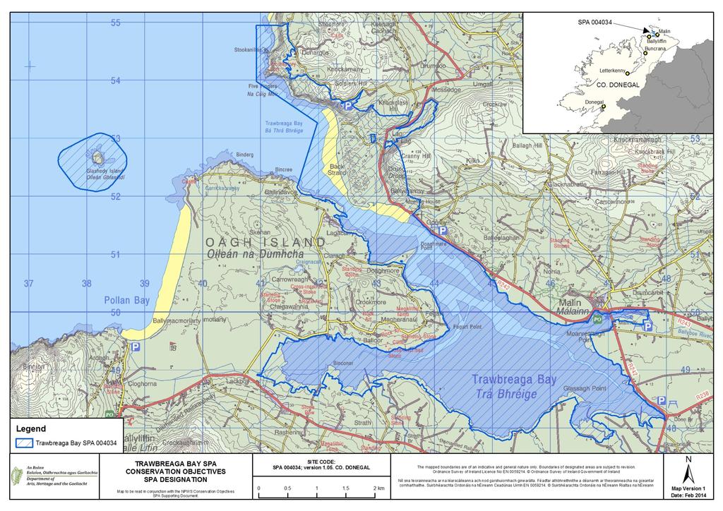
41 38
42 APPENDIX 2 Waterbird data sources Irish Wetland Bird Survey (I-WeBS) I-WeBS began in the Republic of Ireland in 1994/95 and aims to monitor wintering (non-breeding) waterbird populations at the wetland sites upon which they rely. Counts are carried out by volunteers and professional staff of the partner organisations across the months September to March of each year. I-WeBS counts take place on a rising tide or close to high tide. For further information please refer to Crowe (2005). The I-WeBS Programme monitors the larger coastal wetland sites together with inland lakes, turloughs, rivers and callows. However the resulting dataset is incomplete for some waterbird species that utilise other habitats such as non-wetland habitat (e.g. grassland used by many species and particularly foraging geese, and swans), non-estuarine coastline, small and ephemeral wetlands and the open sea; the latter of which is obviously difficult to monitor from land-based surveys (Crowe, 2005). A number of additional and special surveys are therefore conducted on an annual or regular basis and data collected are, where appropriate, integrated into the I-WeBS database. These surveys include those undertaken for swan and geese species that forage typically during daylight hours across terrestrial habitats (e.g. grassland, arable fields) using coastal wetlands sites at night when they congregate to roost. Some of the additional surveys are carried out at certain times, aimed at providing a better estimate of numbers (e.g. Greylag Geese) and for some species an assessment of breeding success during the previous summer (e.g. Light-bellied Brent Geese). These surveys are introduced briefly below and more information is provided in Crowe (2005). Swan Surveys Coordinated international censuses are carried out of the wintering populations of Whooper Swan (Cygnus cygnus) and Bewick s Swan (Cygnus columbianus bewickii at four or five-yearly intervals. The surveys are organised by I-WeBS, the Irish Whooper Swan Study group (IWSSG) and WWT. Greenland White-fronted Goose Greenland White-fronted Geese are concentrated at relatively few sites during winter, many of which are non-wetland habitats. The species is therefore not covered adequately by the I-WeBS programme. The Greenland White-fronted Goose census was initiated in the late 1970 s and is carried out by NPWS in Ireland and by JNCC and Scottish Natural Heritage (SNH) in Scotland. Greylag Geese Data for the Icelandic breeding population of Greylag Goose that winters in Ireland are taken from special surveys organised through I-WeBS and undertaken during November each year. The surveys aim to assess the distribution and status of the migratory flocks wintering in Ireland and focus on known feeding areas (grassland & agricultural land). When calculating population estimates of the Icelandic birds, data collected are adjusted to account for feral flocks that also occur within Ireland. Barnacle Goose (Branta leucopsis) A wintering population from the northeast Greenland breeding population winters mainly on offshore islands along the west coast of Ireland. An aerial survey is conducted of the principal wintering areas every four to five years. Light-bellied Brent Geese Special autumn surveys of this species have been conducted since 1996 and organised in the Republic of Ireland by the Irish Brent Goose Research Group (IBGRG). The survey is currently conducted on a bi-annual basis during the month of October which coincides with the autumn arrival of the species. Data collected are integrated into the I-WeBS database. 39
43 APPENDIX 3 Analysing population trends: a synopsis Monitoring of non-breeding waterbirds has been undertaken by the Irish Wetland Bird Survey (I-WeBS) and its partner, WeBS in Northern Ireland, since the mid 1990 s. For such long-term count data, there is clearly a need to assess long-term trends in a consistent and objective manner (Atkinson et al. 2006). The first stage in the analytical process involves the use of the Underhill Program (Underhill & Prŷs- Jones, 1994) which models the raw monthly counts using a Generalised Linear Model (GLM). As part of this process, it accounts for changes in numbers at the site and the timing of the count (month, year) while also taking into account completed counts and trends at other sites. When counts at a site are flagged as poor quality (e.g. due to poor visibility) or where there are missing values in a given month, then the modelled values are used. This imputation process is used widely to replace missing data points (e.g. Houlahan et al. 2000; Atkinson et al. 2006; Leech et al. 2002; Gregory et al. 2005; Crowe et al. 2008). The resulting dataset is therefore complete for all months and seasons and comprises a combination of actual count data and imputed count data. This complete dataset is then modelled using a Generalised Additive Models (GAM) which fits a smoothed curve to the counts. GAMs are non-parametric and flexible extensions of the generalised linear model where the linear predictor of the GLM is replaced by a general additive predictor which allows mean abundance to vary as a smooth function of time. Count data are assumed to follow independent Poisson distribution with 0.3T degrees of freedom (e.g. after Atkinson et al. 2006). The application of GAMs to analyse population trends was applied to UK farmland birds by Fewster et al. (2000) and has since been adopted for modelling waterbird trends elsewhere, for example, the UK WeBS Alert system (Leech et al. 2002). Smoothed count data for a site are then indexed to assess population trends over time. An index number can be defined as a measure of population size in one year expressed in relation to the size of the population in another selected year (Leech et al. 2002). Changes in the index numbers can therefore explain the pattern of population change over time (Underhill & Prŷs-Jones, 1994). Annual indices are calculated separately for each species at a site. For each year included in an analysis, a total is obtained by summing the number of birds present in a predetermined number of months. The final year in the series of totals is then scaled to equal 100 (please see example in table). Index values in any given year therefore represent the number of individuals relative to those present in the final year. As this process is the same across all species and all sites analysed it allows for some useful comparisons. Count Data Index Un-smoothed indices are also calculated and provide a means of examining ( eye-balling ) the variation across time and can also be used to provide a measure of the mean annual change over the entire period. However, the GAM extension to the methodology and resultant smoothed indices allows for the calculation of proportional change in population size between one season and another. This latter calculation is used in Section 4.2 whereby trends are calculated for the long-term 14-year period (1995/ /10) and the recent five-year period (2004/ /10). The values given represent the percentage change in index (population) values across the specified time period, calculated by subtracting the smoothed index value at the start of the time-frame (1995) from the smoothed index value in the reference year (2009):- Change = ((I y I x) / I x ) x 100 where I y is the index from the current year and I x is the index value at the start of the selected time period (see example below) The reference year is the penultimate year in the time series because, when smoothing, the GAM takes into account values from both the preceding and following year. The last value in the smoothed dataset (2010) is therefore likely to be the least robust because it has no following year. The final result is therefore % change in population size across a specified time period. Larger values indicate larger proportional changes in population size; positive values indicating relative increases while negative values indicate relative decreases over the specified time period. 40
44 Worked example Year Unsmoothed Smoothed Term Change 5YR YR ALL YR Further information on population indexing and trend analysis can be found in various references; for particular reference to waterbirds see Leech et al (2002) and Atkinson et al. (2006). For information on the UK WeBS Alerts system, please see Thaxter et al. (2010) and Cook et al. (2013). Limitations The months chosen for the calculation of population indices aim to reflect the months when the populations at a site are the most stable, excluding months when there may be fluctuations due to passage populations. Despite this, some datasets still present a high degree of variability or fluctuation both within and between years. Because of this, we assess each species separately and take into account where a species shows a history of wide fluctuations between years (within national dataset), or where a species naturally exhibits within-season fluctuations (e.g. species considered to have weak site faithfulness). Where necessary the results of the trend analysis are assigned necessary caution. A high proportion of imputed counts can limit the effectiveness of the analysis to aid in the interpretation of the dataset. Species for which 50% or more of the monthly count values are imputed are excluded from analysis. But sometimes the calculation of population change may involve a comparison between winters where, at least one has a value based on a high proportion of imputed data. Where data for adjacent winters are relatively complete this is not a serious concern because of the smoothing technique used. However, where data for a number of consecutive winters rely heavily on imputed data then the resulting result is considered less reliable (Thaxter et al. 2010). Where necessary the results of the trend analysis are assigned necessary caution. Despite the smoothing effects of the GAM analysis, interpretation of population trends may sometimes still be difficult. Therefore we calculate proportional change in the population across differing time periods (e.g. 12-year, 10-year and 5-year periods) to assess more effectively how the population has fared over time. 41
45 APPENDIX 4 Waterbird species codes AE Arctic Tern Sterna paradisaea BY Barnacle Goose Branta leucopsis BA Bar-tailed Godwit Limosa lapponica BE Bean Goose Anser fabalis BS Bewick s Swan Cygnus columbianus AS Black Swan Cygnus atratus BH Black-headed Gull Chroicocephalus ridibundus BN Black-necked Grebe Podiceps nigricollis BW Black-tailed Godwit Limosa limosa BV Black-throated Diver Gavia arctica BG Brent Goose Branta bernicla CG Canada Goose Branta canadensis CM Common Gull Larus canus CS Common Sandpiper Actitis hypoleucos CX Common Scoter Melanitta nigra CN Common Tern Sterna hirundo CO Coot Fulica atra CA Cormorant Phalacrocorax carbo CU Curlew Numenius arquata CV Curlew Sandpiper Calidris ferruginea DN Dunlin Calidris alpina GA Gadwall Anas strepera GP Golden Plover Pluvialis apricaria GN Goldeneye Bucephala clangula GD Goosander Mergus merganser GB Great Black-backed Gull Larus marinus GG Great Crested Grebe Podiceps cristatus ND Great Northern Diver Gavia immer NW Greenland White-fronted Goose Anser albifrons flavirostris GK Greenshank Tringa nebularia H. Grey Heron Ardea cinerea GV Grey Plover Pluvialis squatarola GJ Greylag Goose Anser anser HG Herring Gull Larus argentatus JS Jack Snipe Lymnocryptes minimus KF Kingfisher Alcedo atthis KN Knot Calidris canutus L. Lapwing Vanellus vanellus 42
46 LB Lesser Black-backed Gull Larus fuscus PB Light-bellied Brent Goose Branta bernicla hrotra ET Little Egret Egretta garzetta LG Little Grebe Tachybaptus ruficollis AF Little Tern Sterna albifrons MA Mallard Anas platyrhynchos MU Mediterranean Gull Larus melanocephalus MH Moorhen Gallinula chloropus MS Mute Swan Cygnus olor OC Oystercatcher Haematopus ostralegus PG Pink-footed Goose Anser brachyrhynchus PT Pintail Anas acuta PO Pochard Aythya ferina PS Purple Sandpiper Calidris maritima RM Red-breasted Merganser Mergus serrator RH Red-throated Diver Gavia stellata RK Redshank Tringa totanus RP Ringed Plover Charadrius hiaticula RU Ruff Philomachus pugnax SS Sanderling Calidris alba TE Sandwich Tern Sterna sandvicensis SP Scaup Aythya marila SU Shelduck Tadorna tadorna SV Shoveler Anas clypeata SY Smew Mergus albellus SN Snipe Gallinago gallinago NB Spoonbill Platalea leucorodia DR Spotted Redshank Tringa erythropus T. Teal Anas crecca TU Tufted Duck Aythya fuligula TT Turnstone Arenaria interpres WA Water Rail Rallus aquaticus WM Whimbrel Numenius phaeopus WG White-fronted Goose Anser albifrons WS Whooper Swan Cygnus Cygnus WN Wigeon Anas penelope WK Woodcock Scolopax rusticola 43
47 APPENDIX 5 Waterbird foraging guilds (after Weller, 1999) Guild Foods Tactics Examples (1) Surface swimmer Invertebrates, vegetation & seeds Strain/sieve/sweep/dabble/gr ab/up-ending Dabbling ducks ; e.g. Shoveler, Teal, Mallard, Pintail, Wigeon, Gadwall (2) Water column diver shallow a Fish & Invertebrates; Search/grab Diving ducks e.g. Pochard, Tufted Duck, Scaup, Eider, (3) Water column diver greater depths (4) Intertidal walker, out of water (5) Intertidal walker, out of water (6) Intertidal walker, in water (7) Terrestrial, walker (e.g. grassland/marsh) a dives <3m. Fish & Invertebrates Search/grab Common Scoter, divers, grebes, Cormorant Invertebrates Search (probe)/grab Sandpipers, plovers Invertebrates, vegetation Sieve/grab/graze Shelduck, Avocet, Spoonbill, Wigeon, Light-Bellied Brent Goose, Fish Search/strike Grey Heron Fish, Invertebrates Probe, scythe, sweep/grab Spoonbill, Greenshank Fish Stalk Little Egret Invertebrates Probe Several sandpiper species Vegetation (inc. roots, tubers & seeds) Graze, peck, probe Many geese species Please note that this table refers to generalised foraging strategies and is meant as a guide only. There is a great deal of variation between sites, seasons, tidal states and indeed, individual birds themselves. For example, some waterbird species may deploy several of the methods, e.g. Shelduck may forage by sieving intertidal mud (5) or by up-ending (1) and Pintail, although generally known as a dabbling duck, does occasionally dive for food. 44
48 APPENDIX 6 Trawbreaga Bay SPA Waterbird Survey Programme 2009/10 Count Subsites Subsite Subsite Name Area (ha) 0A438 Southwest inlet 168 0A439 Trawbreaga south 496 0A440 Doon Bridge-Glassagh Point 129 0A441 Malin 44 0A442 North central 223 0A443 Northwest 176 TOTAL
49 46
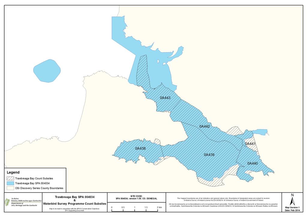
50 47
51 APPENDIX 7 Trawbreaga Bay Waterbird distribution (dot-density diagrams) recorded during the low tide surveys (October 2009 February 2010) 48
52 49
53 50

54 51
Mid-Clare Coast Special Protection Area. Conservation Objectives Supporting Document
 Mid-Clare Coast Special Protection Area (Site Code 4182) Conservation Objectives Supporting Document VERSION 1 National Parks & Wildlife Service July 2014 SUMMARY T A B L E O F C O N T E N T S PART ONE
Tramore Back Strand Special Protection Area. Conservation Objectives Supporting Document
 Tramore Back Strand Special Protection Area (Site Code 4027) Conservation Objectives Supporting Document VERSION 1 National Parks & Wildlife Service September 2013 SUMMARY T A B L E O F C O N T E N T S
Malahide Estuary Special Protection Area. Conservation Objectives Supporting Document
 Malahide Estuary Special Protection Area (Site Code 4025) Conservation Objectives Supporting Document VERSION 1 National Parks & Wildlife Service August 2013 SUMMARY T A B L E O F C O N T E N T S PART
Baldoyle Bay Special Protection Area. Conservation Objectives Supporting Document
 Baldoyle Bay Special Protection Area (Site Code 4016) Conservation Objectives Supporting Document VERSION 1 National Parks & Wildlife Service December 2012 SUMMARY T A B L E O F C O N T E N T S PART ONE
Castlemaine Harbour Special Protection Area. (Site Code 4029) Version 2. Conservation Objectives Supporting Document
 Version 2. Conservation Objectives Supporting Document") Castlemaine Harbour Special Protection Area (Site Code 4029) Version 2 Conservation Objectives Supporting Document National Parks & Wildlife Service March 2011 T A B L E O F C O N T E N T S PART ONE -
Castlemaine Harbour Special Protection Area (Site Code 4029) Version 2 Conservation Objectives Supporting Document National Parks & Wildlife Service March 2011 T A B L E O F C O N T E N T S PART ONE -
Donegal Bay Special Protection Area. Conservation Objectives Supporting Document
 Donegal Bay Special Protection Area (Site Code 4151) Conservation Objectives Supporting Document VERSION 1 National Parks & Wildlife Service January 2012 SUMMARY T A B L E O F C O N T E N T S PART ONE
Rogerstown Estuary Special Protection Area. Conservation Objectives Supporting Document
 Rogerstown Estuary Special Protection Area (Site Code 4015) Conservation Objectives Supporting Document VERSION 1 National Parks & Wildlife Service May 2013 T A B L E O F C O N T E N T S SUMMARY PART ONE
Blacksod Bay/Broad Haven Special Protection Area. Conservation Objectives Supporting Document
 Blacksod Bay/Broad Haven Special Protection Area (Site Code 4037) Conservation Objectives Supporting Document VERSION 1 National Parks & Wildlife Service November 2014 SUMMARY T A B L E O F C O N T E N
North Bull Island Special Protection Area (Site Code 4006) South Dublin Bay and River Tolka Estuary Special Protection Area (Site Code 4024)
 South Dublin Bay and River Tolka Estuary Special Protection Area (Site Code 4024)") North Bull Island Special Protection Area (Site Code 4006) & South Dublin Bay and River Tolka Estuary Special Protection Area (Site Code 4024) Conservation Objectives Supporting Document VERSION 1 National
North Bull Island Special Protection Area (Site Code 4006) & South Dublin Bay and River Tolka Estuary Special Protection Area (Site Code 4024) Conservation Objectives Supporting Document VERSION 1 National
4.20 BLACKWATER ESTUARY
 4.20 BLACKWATER ESTUARY LTC site code: CB Centre grid: TL9507 JNCC estuarine review site: 112 Habitat zonation: 2368 ha intertidal, 1587 ha subtidal, 766 ha nontidal Statutory status: Blackwater Estuary
The Effects on Waterbirds of Dredging at the Cardiff Bay Barrage Report for 2005/06
 The Effects on Waterbirds of Dredging at the Cardiff Bay Barrage Report for 2005/06 Authors N.H.K. Burton & S.J. Holloway Report of work carried out by The British Trust for Ornithology under contract
Cabra, Dublin 7. Appropriate assessment (screening) Report prepared for Crekav Trading GP Limited. November 2017
 Report prepared for Crekav Trading GP Limited. November 2017") Proposed development at Former CIE Lands, Carnlough Road, Cabra, Dublin 7 Appropriate assessment (screening) Report prepared for Crekav Trading GP Limited November 2017 Roger Goodwillie & Associates, Lavistown
Proposed development at Former CIE Lands, Carnlough Road, Cabra, Dublin 7 Appropriate assessment (screening) Report prepared for Crekav Trading GP Limited November 2017 Roger Goodwillie & Associates, Lavistown
4.18 HAMFORD WATER. LTC site code:
 4.18 HAMFORD WATER LTC site code: BH Centre grid: TM2325 JNCC estuarine review site: 110 Habitat zonation: 367 ha intertidal, 106 ha subtidal, 58 ha nontidal Statutory status: Hamford Water SPA (UK9009131),
BROADMEADOW RIVER ESTUARY (SWORDS/MALAHIDE), CO. DUBLIN
, CO. DUBLIN") BROADMEADOW RIVER ESTUARY (SWORDS/MALAHIDE), CO. DUBLIN WATERBIRDS IN JULY AND AUGUST 2008 (with additional counts from 2004-2008) Oscar J. Merne, M.Sc. Ornithologist & Environmental Scientist August 2008
BROADMEADOW RIVER ESTUARY (SWORDS/MALAHIDE), CO. DUBLIN WATERBIRDS IN JULY AND AUGUST 2008 (with additional counts from 2004-2008) Oscar J. Merne, M.Sc. Ornithologist & Environmental Scientist August 2008
National Parks and Wildlife Service
 ISSN 2009-4086 National Parks and Wildlife Service Conservation Objectives Series South Dublin Bay and River Tolka Estuary SPA 004024 Page 1 of 23 National Parks and Wildlife Service, Department of Arts,
National Parks and Wildlife Service
 National Parks and Wildlife Service Conservation Objectives Series Wexford Harbour and Slobs SPA 004076 Page 1 of 39 National Parks and Wildlife Service, Department of Arts, Heritage and the Gaeltacht,
THE MERSEY GATEWAY PROJECT (MERSEY GATEWAY BRIDGE) AVIAN ECOLOGY SUMMARY PROOF OF EVIDENCE OF. Paul Oldfield
 AVIAN ECOLOGY SUMMARY PROOF OF EVIDENCE OF. Paul Oldfield") HBC/14/3S THE MERSEY GATEWAY PROJECT (MERSEY GATEWAY BRIDGE) AVIAN ECOLOGY SUMMARY PROOF OF EVIDENCE OF Paul Oldfield 1 1 DESCRIPTION OF THE BIRDLIFE IN THE UPPER MERSEY ESTUARY LOCAL WILDLIFE SITE 1.1
HBC/14/3S THE MERSEY GATEWAY PROJECT (MERSEY GATEWAY BRIDGE) AVIAN ECOLOGY SUMMARY PROOF OF EVIDENCE OF Paul Oldfield 1 1 DESCRIPTION OF THE BIRDLIFE IN THE UPPER MERSEY ESTUARY LOCAL WILDLIFE SITE 1.1
OFFICE OF ENVIRONMENTAL SUSTAINABILITY
 This report has been cleared for submission by David Flynn. Eve O'Sullivan, 13/03/2018 10:52 OFFICE OF ENVIRONMENTAL SUSTAINABILITY ENVIRONMENTAL LICENSING PROGRAMME TO: Eimear Cotter, Director FROM: Brian
James Latham (Ecological Consultant)
") Identification of wintering waterbird high tide roosts on the Severn Estuary SSSI/SPA (Brean Down to Clevedon) Date: 10 th July 2015 This report has been prepared for: Natural England By: James Latham
Identification of wintering waterbird high tide roosts on the Severn Estuary SSSI/SPA (Brean Down to Clevedon) Date: 10 th July 2015 This report has been prepared for: Natural England By: James Latham
Humber Management Scheme. Fact sheet: Wintering and passage birds
 Humber Management Scheme Fact sheet: Wintering and passage birds Introduction The Humber Estuary plays an international role in bird migration and is one of the most important wetland sites in the UK.
JNCC estuarine review site: ha intertidal, 1024 ha subtidal, 541 ha nontidal
 4.56 DUDDON ESTUARY LTC site code: BD Centre grid: SD1977 JNCC estuarine review site: 39 Habitat zonation: 3589 ha intertidal, 1024 ha subtidal, 541 ha nontidal Statutory status: Duddon Estuary SPA (UK9005031),
APPENDIX 11.2 BRENT GEESE SURVEY REPORT
 APPENDIX 11.2 BRENT GEESE SURVEY REPORT Light-bellied Brent Goose presence on Alfie Byrne Road Green Space and Belcamp Park in Dublin City along route corridor for proposed aviation fuel pipeline SUMMARY
Dispersed Waterbirds Survey
 Dispersed Waterbirds Survey Title Dispersed Waterbird Survey 2002/03 Description and Summary of Results The main wetland sites are counted by the Wetland Bird Survey (WeBS) Core Counts -- monthly counts
The Effect of the Cardiff Bay Barrage on Waterbird Populations Final Report
 The Effect of the Cardiff Bay Barrage on Waterbird Populations Final Report Authors N.H.K. Burton, M.M. Rehfisch & N.A. Clark Report of work carried out by The British Trust for Ornithology under contract
STOUR ESTUARY Essex, Suffolk
 STOUR ESTUARY Essex, Suffolk Internationally important: Nationally important: Pintail, Grey Plover, Knot, Dunlin, Black-tailed Godwit, Redshank Great Crested Grebe, Dark-bellied Brent Goose, Shelduck,
APPENDIX 11O WINTERING SWAN AND GOOSE
 APPENDIX 11O WINTERING SWAN AND GOOSE Legislation The following legislation is the most relevant to whooper swan Cygnus cygnus and greylag geese Anser anser within the study area. The Conservation (Nature
Assessing ornithological impacts associated with wind farm developments: surveying recommendations
 Assessing ornithological impacts associated with wind farm developments: surveying recommendations This information note has been written to provide guidance to developers, Competent Authorities and others
Branta leucopsis East Greenland/Scotland & Ireland
 Period 2008-2012 European Environment Agency European Topic Centre on Biological Diversity Branta leucopsis East Greenland/Scotland & Ireland Annex I International action plan Yes No Barnacle Goose, Branta
ADDENDUM 1. The River Shannon & River Fergus Estuaries. Waterbird data and SIFP Areas Non-Technical Summary
 ADDENDUM 1 The River Shannon & River Fergus Estuaries Waterbird data and SIFP Areas Non-Technical Summary This addendum provides summary waterbird data for the SIFP areas. Please see Section 3.5 of the
Branta leucopsis Russia/Germany & Netherlands
 Period 2008-2012 European Environment Agency European Topic Centre on Biological Diversity Branta leucopsis Russia/Germany & Netherlands Annex I International action plan Yes No Barnacle Goose, Branta
Office of Climate, Licensing & Resource Use Environmental Protection Agency PO Box 3000 County Wexford 3 August 2010
 Kilcatherine, Eyeries, County Cork http://www.friendsoftheirishenvironment.org Office of Climate, Licensing & Resource Use Environmental Protection Agency PO Box 3000 County Wexford 3 August 2010 Westland
Results of the third Non-Estuarine Waterbird Survey, including Population Estimates for Key Waterbird Species
 Results of the third Non-Estuarine Waterbird Survey, including Population Estimates for Key Waterbird Species Authors Graham Austin, Teresa Frost, Heidi Mellan, Dawn Balmer Report of work carried out by
The Effect of the Cardiff Bay Barrage on Waterbird Populations 12. Distribution and Movement Studies August 2000-May 2001
 The Effect of the Cardiff Bay Barrage on Waterbird Populations 12. Distribution and Movement Studies August 2000-May 2001 Authors N.H.K. Burton, M.M. Rehfisch & N.A. Clark Report of work carried out by
CORE MANAGEMENT PLAN INCLUDING CONSERVATION OBJECTIVES FOR
 CYNGOR CEFN GWLAD CYMRU COUNTRYSIDE COUNCIL FOR WALES CORE MANAGEMENT PLAN INCLUDING CONSERVATION OBJECTIVES FOR TRAETH LAFAN/LAVAN SANDS, CONWAY BAY SPA (incorporating a section of Y Fenai a Bae Conwy/Menai
Calidris alpina schinzii Britain & Ireland/SW Europe & NW Africa
 Period 2008-2012 European Environment Agency European Topic Centre on Biological Diversity Calidris alpina schinzii Britain & Ireland/SW Europe & NW Africa Annex I International action plan Yes No Dunlin,
is selected to co-ordinate the counts at the site level and to provide a single point of contact for the national organiser. At the end of a winter, c
 2 Methods SITE SELECTION The scope of the WeBS Low Tide Counts (LTCs) is estuarine sites throughout the United Kingdom. When the LTCs were originally planned, the aim was to systematically census each
Agreement on the Conservation of African-Eurasian Migratory Waterbirds (AEWA)
") Agreement on the Conservation of African-Eurasian Migratory Waterbirds (AEWA) A Tool for International Cooperation AEWA - An International Treaty Safeguarding Migratory Waterbirds The Agreement on the
Agreement on the Conservation of African-Eurasian Migratory Waterbirds (AEWA) A Tool for International Cooperation AEWA - An International Treaty Safeguarding Migratory Waterbirds The Agreement on the
Report to Inform an Appropriate Assessment for the Firth of Forth SPA
 Report to Inform an Appropriate Assessment for the Firth of Forth SPA November 2009 No part of this report may be copied or reproduced by any means without prior written permission from Jacobs Arup - Jacobs
Summary of protection values of Finnish marine protection areas
 Appendix 5 Summary of protection values of Finnish marine protection areas s Table lists relevant Finnish Marine s in the vicinity of NSP2 project area and their conservation objectives. Sites are listed
WeBS Alerts 1998/99: Changes in numbers of wintering waterbirds in the United Kingdom at national, country and Special Protection Area (SPA) scales
 scales") WeBS s 1998/99: Changes in numbers of wintering waterbirds in the United Kingdom at national, country and Special Protection Area (SPA) scales Authors Philip W. Atkinson, Graham E. Austin, Niall H.K. Burton,
WeBS s 1998/99: Changes in numbers of wintering waterbirds in the United Kingdom at national, country and Special Protection Area (SPA) scales Authors Philip W. Atkinson, Graham E. Austin, Niall H.K. Burton,
Stour and Orwell Estuary European marine site
 Stour and Orwell Estuary European marine site English Nature s advice given under Regulation 33(2) of the Conservation (Natural Habitats &c.) Regulations 1994 English Nature s advice for Stour and Orwell
Calidris alpina schinzii Baltic/SW Europe & NW Africa
 Period 2008-2012 European Environment Agency European Topic Centre on Biological Diversity Calidris alpina schinzii Baltic/SW Europe & NW Africa Annex I International action plan Yes No Dunlin, Calidris
BirdLife International Marine Programme Marine Important Bird & Biodiversity Areas (Marine IBAs)
") Photo: Pep Arcos BirdLife International Marine Programme Marine Important Bird & Biodiversity Areas (Marine IBAs) Marguerite Tarzia- Marine Conservation Officer, BirdLife Europe marguerite.tarzia@birdlife.org
Photo: Pep Arcos BirdLife International Marine Programme Marine Important Bird & Biodiversity Areas (Marine IBAs) Marguerite Tarzia- Marine Conservation Officer, BirdLife Europe marguerite.tarzia@birdlife.org
Wintering Corn Buntings
 Wintering Corn Buntings Title Wintering Corn Bunting 1992/93 Description and Summary of Results The Corn Bunting Emberiza calandra is one of a number of farmland birds which showed a marked decline in
PORTSMOUTH HARBOUR Hampshire
 PORTSMOUTH HARBOUR Hampshire Internationally important: Nationally important: None Dark-bellied Brent Goose, Red-breasted Merganser, Black-tailed Godwit Site description This large harbour in the Solent
Waterbird Disturbance Mitigation Toolkit Informing Estuarine Planning & Construction Projects
 Waterbird Disturbance Mitigation Toolkit Informing Estuarine Planning & Construction Projects Click on the Photograph to Enter Authors: N Cutts K Hemingway & J Spencer Version 3.2, March 2013 Copyright
HELCOM workshop on migratory waterbirds
 HELCOM workshop on migratory waterbirds Helsinki, 20-22 November 2018 Aims: Produce maps with migration routes of waterbird species (e.g. seabirds, ducks, waders) covering the entire Baltic Sea Region.
State of nature in the EU: results from the reporting under the nature directives
 State of nature in the EU: results from the reporting under the nature directives 2007-2012 18 th Meeting Co-ordination Group for Biodiversity and Nature 12 March 2015 1 EEA technical report Contents Introduction
Farr wind farm: A review of displacement disturbance on dunlin arising from operational turbines
 Farr wind farm: A review of displacement disturbance on dunlin arising from operational turbines 2002-2015. Alan H Fielding and Paul F Haworth September 2015 Haworth Conservation Haworth Conservation Ltd
LOUTH COUNTY COUNCIL. DRAFT LOCAL ECONOMIC & COMMUNITY PLAN Appropriate Assessment (AA) Screening Report DRAFT LECP
 Screening Report DRAFT LECP") LOUTH COUNTY COUNCIL DRAFT LOCAL ECONOMIC & COMMUNITY PLAN 2016-2022 Appropriate Assessment (AA) Screening Report A Plan for the promotion of economic and community development in County Louth TABLE OF
LOUTH COUNTY COUNCIL DRAFT LOCAL ECONOMIC & COMMUNITY PLAN 2016-2022 Appropriate Assessment (AA) Screening Report A Plan for the promotion of economic and community development in County Louth TABLE OF
Review and analysis of changes in waterbird use of the Mersey Estuary SPA, Mersey Narrows & North Wirral Foreshore pspa and Ribble & Alt Estuaries SPA
 Natural England Commissioned Report NECR173 Review and analysis of changes in waterbird use of the Mersey Estuary SPA, Mersey Narrows & North Wirral Foreshore pspa and Ribble & Alt Estuaries SPA First
Supplementary material
 Supplementary material Thomas Bregnballe, Ole Amstrup, Thomas E. Holm, Preben Clausen & Anthony D. Fox: Skjern River Valley, Northern Europe s most expensive wetland restoration project: benefits to breeding
WWT/JNCC/SNH Goose & Swan Monitoring Programme survey results 2005/06
 1. Abundance WWT/JNCC/SNH Goose & Swan Monitoring Programme survey results 2005/06 Whooper swan Cygnus cygnus The fifth international census of Whooper Swans wintering in Britain, Ireland and Iceland was
STANDARD DATA FORM FOR SPECIAL PROTECTION AREAS (SPA) FOR SITES ELIGIBLE FOR IDENTIFICATION AS SITES OF COMMUNITY IMPORTANCE (SCI) AND
 FOR SITES ELIGIBLE FOR IDENTIFICATION AS SITES OF COMMUNITY IMPORTANCE (SCI) AND") Start Form NF004005 Site code: NATURA 2000 STANDARD DATA FORM FOR SPECIAL PROTECTION AREAS (SPA) FOR SITES ELIGIBLE FOR IDENTIFICATION AS SITES OF COMMUNITY IMPORTANCE (SCI) AND FOR SPECIAL AREAS OF CONSERVATION
Start Form NF004005 Site code: NATURA 2000 STANDARD DATA FORM FOR SPECIAL PROTECTION AREAS (SPA) FOR SITES ELIGIBLE FOR IDENTIFICATION AS SITES OF COMMUNITY IMPORTANCE (SCI) AND FOR SPECIAL AREAS OF CONSERVATION
3 March 2015 The Director Sustainable Fisheries Section Department of the Environment GPO Box 787 CANBERRA ACT 2601
 3 March 2015 The Director Sustainable Fisheries Section Department of the Environment GPO Box 787 CANBERRA ACT 2601 SustainableFisheries@environment.gov.au Dear Director, Birdlife Australia welcomes the
LANCASTER BYPASS WINTER 2000/2001
 LANCASTER BYPASS WINTER 2000/2001 Authors S. J. Holloway & N. A. Clark Report of work carried out by The British Trust for Ornithology under contract to Lancashire County Council British Trust for Ornithology
General report format, ref. Article 12 of the Birds Directive, for the report
 Annex 1: General report format, ref. Article 12 of the Birds Directive, for the 2008-2012 report 0. Member State Select the 2 digit code for your country, according to list to be found in the reference
Anser fabalis fabalis North-east Europe/North-west Europe
 Period 2008-2012 European Environment Agency European Topic Centre on Biological Diversity Anser fabalis fabalis North-east Europe/North-west Europe Annex I International action plan No No Bean Goose,
JNCC estuarine review site: ha intertidal, 608 ha subtidal, 27 ha nontidal Statutory status: Winter waterbird interest:
 4.50 CONWY ESTUARY LTC site code: EC Centre grid: SH7976 JNCC estuarine review site: 32 Habitat zonation: 1009 ha intertidal, 608 ha subtidal, 27 ha nontidal Statutory status: N/A Winter waterbird interest:
THE PROPOSED DUBLIN ARRAY WIND FARM ASSESSMENT OF POTENTIAL IMPACTS ON SEABIRDS
 THE PROPOSED DUBLIN ARRAY WIND FARM ASSESSMENT OF POTENTIAL IMPACTS ON SEABIRDS Information in support of the Appropriate Assessment of the proposed Wind Farm Report for: Prepared by: February 2013. THE
Migratory Shorebird Conservation Action Plan
 Migratory Shorebird Conservation Action Plan The Migratory Shorebird Conservation Action Plan (MS CAP) has been developed by a broad range of stakeholders from all across the country and internationally
Working with wildlife A DAY IN THE LIFE
 EPA ACTIVITY WORKSHEET STUDENT PAGE 1 7 Theme Student Sheet. This is the story of a scientist and their work on a day to day basis. Objectives To give students an insight into the work of scientists and
North Solent Shoreline Management Plan. Appendix J: Appropriate Assessment
 North Solent Shoreline Management Plan Appendix J: Appropriate Assessment Contents Page No J1 INTRODUCTION...1 J1.1 Background...1 J1.2 Role of Organisations in the Appropriate Assessment Process...8
LOCH LEVEN NATIONAL NATURE RESERVE (NNR) Proposed Local Access Guidance
 Proposed Local Access Guidance") LOCH LEVEN NATIONAL NATURE RESERVE (NNR) Proposed Local Access Guidance Summary This paper briefly outlines the rationale behind the proposed local access guidance for Loch Leven NNR. Introduction SNH
LOCH LEVEN NATIONAL NATURE RESERVE (NNR) Proposed Local Access Guidance Summary This paper briefly outlines the rationale behind the proposed local access guidance for Loch Leven NNR. Introduction SNH
Little Ringed Plover 2007
 Little Ringed Plover 2007 Title Breeding Plover Survey 2007 (Little Ringed Plover) (Note: In the breeding season of 2007, the BTO ran a UK-wide survey covering both Little Ringed Charadrius dubius and
Impact of wind farms on birds and bats
 Impact of wind farms on birds and bats Dr. Hermann Hötker Michael-Otto-Institut im NABU BirdLife Partner Germany Methods Disturbance and Displacement Collision mortality Repowering download: http://bergenhusen.nabu.de/bericht/voegelregenergien.pdf
BLACKWATER ESTUARY Essex
 BLACKWATER ESTUARY Essex Internationally important: Nationally important: Dark-bellied Brent Goose, Golden Plover, Grey Plover, Dunlin, Black-tailed Godwit, Redshank Cormorant, Shelduck, Wigeon, Teal,
Northampton Washlands: Frequently Asked Questions
 Northampton Washlands: Frequently Asked Questions Site Significance 1 Why is the site important for wildlife? 2 Why are over wintering birds of such high conservation importance? 3 What are the issues
HABITATS REGULATIONS ASSESSMENT St. Anne s on the Sea Neighbourhood Plan Addendum to Screening Opinion OCTOBER 2016
 HABITATS REGULATIONS ASSESSMENT St. Anne s on the Sea Neighbourhood Plan Addendum to Screening Opinion OCTOBER 2016 CONTACTS JO WEAVER Senior Ecologist dd +44 (0)1453 423124 m +44 (0)7809 549186 e jo.weaver@arcadis.com
Skogsøy Spring Migration. Preliminary Results. Julian Bell
 Skogsøy 26 Spring Migration Preliminary Results Julian Bell 26 1 1. Introduction...4 2. Species Accounts...5 Red-throated Diver Gavia stellata...6 Black-throated Diver Gavia arctica...7 Great Northern
Interim Project Report: Year One
 Interim Project Report: Year One Deborah Whitfield October 2017 Hampshire and Isle of Wight Wildlife Trust 1 Publication Details This document should be cited as: Whitfield, D (2017) Solent Waders and
BC Coastal Waterbird Survey Protocol. Instructions for Participants
 Instructions for Participants Background The coastal marine habitat of British Columbia is home to many species of waterbirds and supports some of the highest densities of seabirds, waterfowl, and shorebirds
2008 San Francisco Bay Shorebird Census
 2008 San Francisco Bay Shorebird Census San Francisco Bay is a great place for shorebirds! The salt ponds, tidal flats, marshes and seasonal wetlands provide important habitat for over a million resident
Table of Contents. 1 Introduction...3
 Cork County Council Proposed Amendment No2 to Midleton Local Area Plan (Carrigtwohill North Framework Masterplan) Habitats Directive Screening Statement Prepared by Cork County Council Planning Policy
SPECIES ACTION PLAN. Rhinolophus ferrumequinum 1 INTRODUCTION 2 CURRENT STATUS 3 CURRENT FACTORS AFFECTING 4 CURRENT ACTION
 GREATER HORSESHOE BAT Rhinolophus ferrumequinum Hampshire Biodiversity Partnership 1 INTRODUCTION The greater horseshoe bat has been identified by the UK Biodiversity steering group report as a species
The Severn Estuary Special Protection Area European Marine Site
 The Severn Estuary Special Protection Area European Marine Site English Nature & the Countryside Council for Wales advice for the Severn Estuary Special Protection Area given under Regulation 33(2) of
Point Grey Tidal Marsh Project Standwatch Surveys February 20, 2014 to March 26, 2014
 Suite 250 1380 Burrard Street Vancouver, BC V6Z 2H3 T: 604.669.0424 F: 604.669.0430 hemmera.com Point Grey Tidal Marsh Project Standwatch Surveys February 20, 2014 to March 26, 2014 Report Date July 22,
Wetland Bird Survey (Core Counts)
") Wetland Bird Survey (Core Counts) Title Wetland Bird Survey (WeBS) Core Counts 1954 to present Description and Summary of Results The UK is known to hold large numbers of waterbirds in the non-breeding
Wetland Bird Survey (Core Counts) Title Wetland Bird Survey (WeBS) Core Counts 1954 to present Description and Summary of Results The UK is known to hold large numbers of waterbirds in the non-breeding
SoN 2015: Landmark report shows European biodiversity going lost at unacceptable rates: intensive agriculture main culprit
 Brussels, 20 May 2015 SoN 2015: Landmark report shows European biodiversity going lost at unacceptable rates: intensive agriculture main culprit Landmark report shows European biodiversity going lost at
Roberts Bank Terminal 2 Project Field Studies Information Sheet
 May 2013 Port Metro Vancouver is continuing field studies in May as part of ongoing environmental and technical work for the proposed Roberts Bank Terminal 2 Project. Roberts Bank Terminal 2 Project The
Guidance note: Distribution of breeding birds in relation to upland wind farms
 Guidance note: Distribution of breeding birds in relation to upland wind farms December 2009 Summary Impacts of wind farms on bird populations can occur through collisions, habitat loss, avoidance/barrier
WeBS Alerts 1999/2000: Changes in Numbers of Wintering Waterbirds in the United Kingdom at National, Country and SSSI Scales
 WeBS Alerts 1999/2000: Changes in Numbers of Wintering Waterbirds in the United Kingdom at National, Country and SSSI Scales Interim Report Authors Philip W. Atkinson, Mark M. Rehfisch & Mark Pollitt Data
STRATEGIC ENVIRONMENTAL ASSESSMENT SCREENING STATEMENT MAINTENANCE ACTIVITIES COASTAL PROTECTION SCHEMES OFFICE OF PUBLIC WORKS ENGINEERING SERVICES
 STRATEGIC ENVIRONMENTAL ASSESSMENT SCREENING STATEMENT MAINTENANCE ACTIVITIES OF COASTAL PROTECTION SCHEMES UNDER THE RESPONSIBILITY OF THE OFFICE OF PUBLIC WORKS ENGINEERING SERVICES OFFICE OF PUBLIC
Bird Sensitivity Mapping for wind energy developments in Ireland Development & Implementation of the mapping tool. birdwatchireland.
 Bird Sensitivity Mapping for wind energy developments in Ireland Development & Implementation of the mapping tool birdwatchireland.ie Guidance document Detailed guidance document Requirement for mapping
4.12 NORTH NORFOLK COAST
 4.12 NORTH NORFOLK COAST LTC site code: CN Centre grid: TF8946 JNCC estuarine review site: 102 Habitat zonation: 3447 ha intertidal, 2490 ha subtidal, 2701 ha nontidal Statutory status: North Norfolk Coast
Waterbirds in the UK SURVEY METHODS WeBS Core Counts
 Waterbirds in the UK SURVEY METHODS The main source of data for this report is the WeBS scheme, providing regular monthly counts for most waterbird species at the majority of the UK s important wetlands.
WATERBIRD MONITORING IN THE CONSERVATION ZONE OF THE CREERY WETLANDS. December 1998 to April 2004
 WATERBIRD MONITORING IN THE CONSERVATION ZONE OF THE CREERY WETLANDS December 1998 to April 2004 Prepared for: RPS Bowman Bishaw Gorham Pty Ltd, 290 Churchill Avenue, Subiaco, WA Prepared by: M.J. & A.R.
Site Improvement Plan. Upper Nene Valley Gravel Pits SPA. Improvement Programme for England's Natura 2000 Sites (IPENS) Planning for the Future
 Planning for the Future") Improvement Programme for England's Natura 2000 Sites (IPENS) Planning for the Future Site Improvement Plan Upper Nene Valley Gravel Pits Site Improvement Plans (SIPs) have been developed for each Natura
Improvement Programme for England's Natura 2000 Sites (IPENS) Planning for the Future Site Improvement Plan Upper Nene Valley Gravel Pits Site Improvement Plans (SIPs) have been developed for each Natura
Possible new marine Special Areas of Conservation and Special Protection Areas in Wales
 Possible new marine Special Areas of Conservation and Special Protection Areas in Wales Photo credit - PGH Evans / Seawatch Foundation // February 2015 www.naturalresourceswales.gov.uk This leaflet provides
Determinants of bird habitat use in TIDE estuaries
 Determinants of bird habitat use in TIDE estuaries Authors: Franco, A., Thomson, S. & N.D. Cutts Institute of Estuarine and Coastal Studies (IECS), University of Hull, UK Acknowledgments The authors would
Project Summary. Predicting waterbird nest distributions on the Yukon-Kuskokwim Delta of Alaska
 Project Summary 1. PROJECT INFORMATION Title Project ID Predicting waterbird nest distributions on the Yukon-Kuskokwim Delta of Alaska WA2012_22 Project Period July 1, 2012 to June 30, 2014 Report submission
Screening Report for Appropriate Assessment of a proposed student residence development at University College Dublin, Dublin 4
 Screening Report for Appropriate Assessment of a proposed student residence development at University College Dublin, Dublin 4 1 Compiled by OPENFIELD Ecological Services Pádraic Fogarty, MSc MIEMA For
working today for nature tomorrow Low tide survey of The Wash Special Protection Area Final report of the winter shorebird survey
 Report Number 589 Low tide survey of The Wash Special Protection Area Final report of the winter 2002-2003 shorebird survey English Nature Research Reports working today for nature tomorrow English Nature
MONITORING DIVERSITY AND ABUNDANCE OF WETLAND BIRDS. Chris Healey President, BirdLife East Gippsland
 MONITORING DIVERSITY AND ABUNDANCE OF WETLAND BIRDS Chris Healey President, BirdLife East Gippsland GIPPSLAND LAKES IMPORTANT BIRD AREA Ramsar site & Important Bird Area (GLIBA) Recognised under international
Agenda item 10 Updating the Key Concepts Document on the Period of Reproduction and Prenuptial Migration of Huntable Species
 Expert Group on the Birds and Habitats Directives NADEG 22-23.5.2018 Brussels Agenda item 10 Updating the Key Concepts Document on the Period of Reproduction and Prenuptial Migration of Huntable Species
National Parks and Wildlife Service
 ISSN 2009-4086 National Parks and Wildlife Service Conservation Objectives Series Glanlough Woods SAC 002315 Page 1 of 7 National Parks and Wildlife Service, Department of Culture, Heritage and the Gaeltacht,
Eurasian Golden Plover (Pluvialis apricaria) wintering in Portugal: recent trend and estimates
 wintering in Portugal: recent trend and estimates") Eurasian Golden Plover (Pluvialis apricaria) wintering in Portugal: recent trend and estimates Domingos Leitão Sociedade Portuguesa para o Estudo das Aves Juan M. Varela Simó Lisboa September 2005 SPEA
Eurasian Golden Plover (Pluvialis apricaria) wintering in Portugal: recent trend and estimates Domingos Leitão Sociedade Portuguesa para o Estudo das Aves Juan M. Varela Simó Lisboa September 2005 SPEA
Alca torda. Report under the Article 12 of the Birds Directive Period Annex I International action plan. No No
 Period 2008-2012 European Environment Agency European Topic Centre on Biological Diversity Annex I International action plan No No Razorbill,, is a species of colonial seabird found in unvegetated or sparsely
Mergellus albellus North-east Europe/Black Sea & East Mediterranean
 Period 2008-2012 European Environment Agency European Topic Centre on Biological Diversity Mergellus albellus North-east Europe/Black Sea & East Mediterranean Annex I International action plan Yes No Smew,
Analysis of sea-watching data from Holme Bird Observatory, Norfolk
 Analysis of sea-watching data from Holme Bird Observatory, Norfolk BTO Authors Aonghais S.C.P. Cook, Chris Thaxter, Lucy J. Wright, Nick J. Moran, Niall H.K. Burton, Jed Andrews, Sophie Barker and Fred