Why 100 feet measured yesterday may not necessarily equal 100 feet today
|
|
|
- Julia Horn
- 5 years ago
- Views:
Transcription
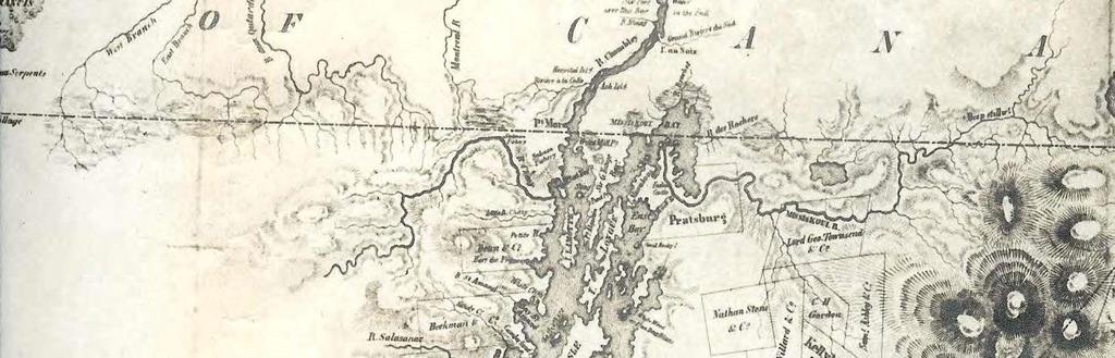
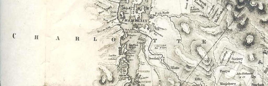
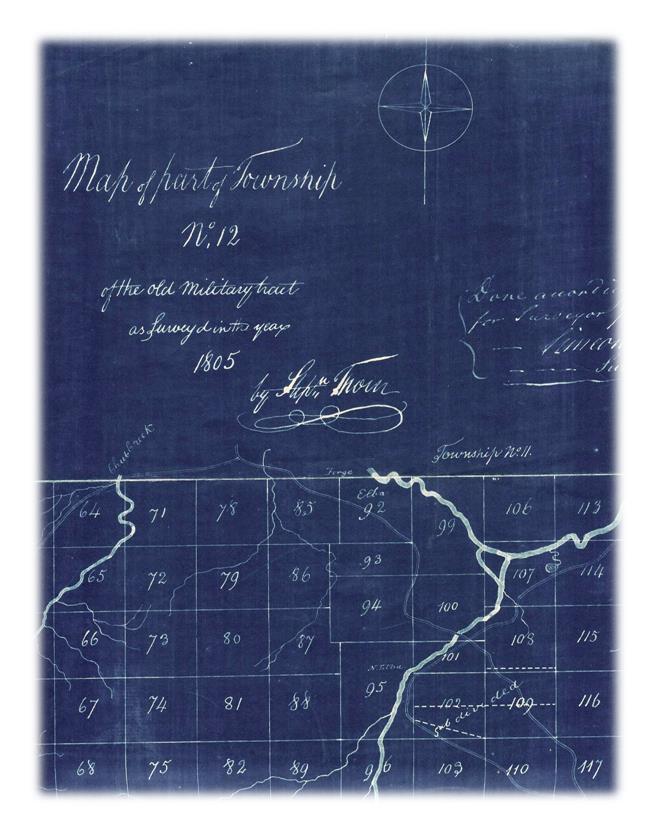
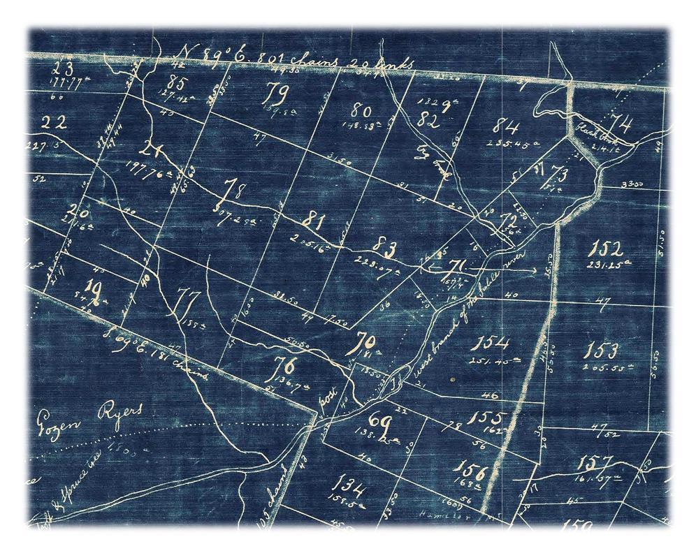
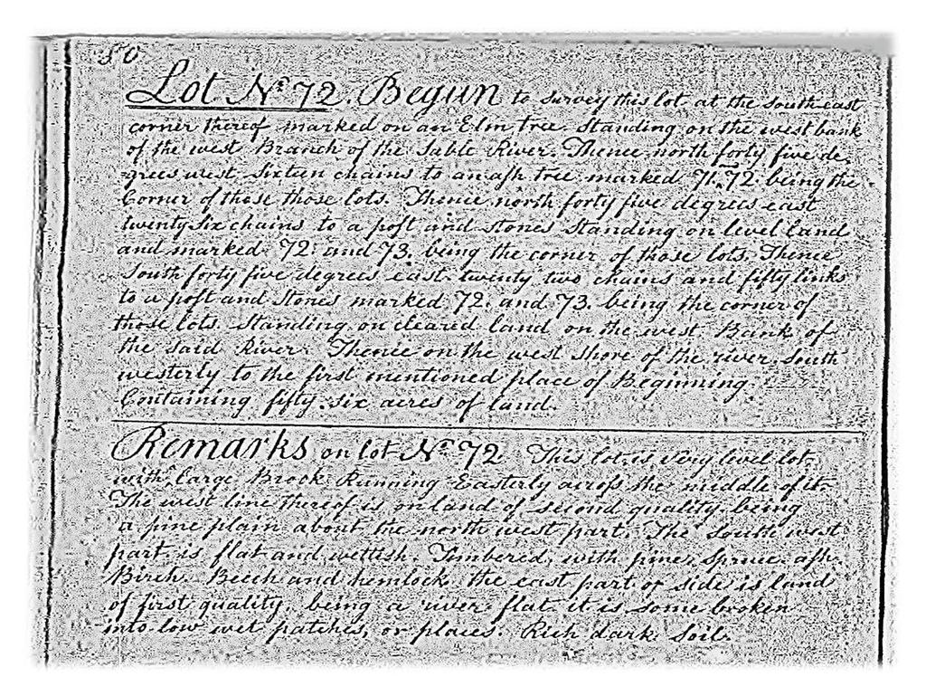
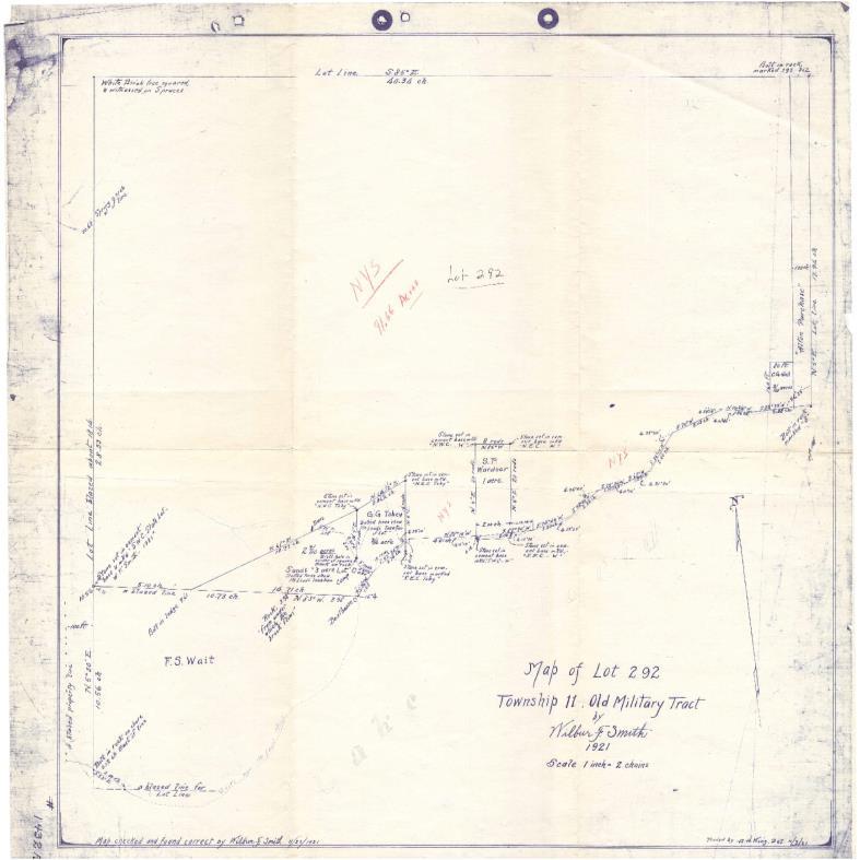
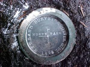
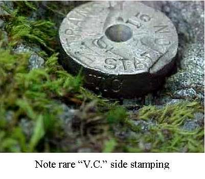
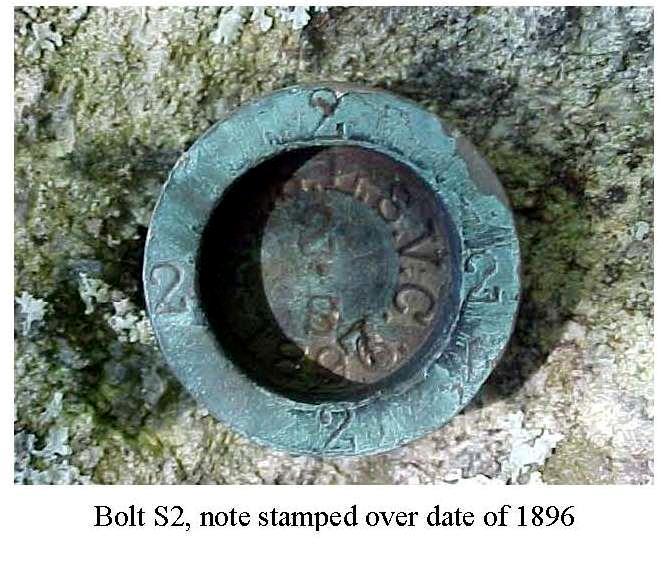
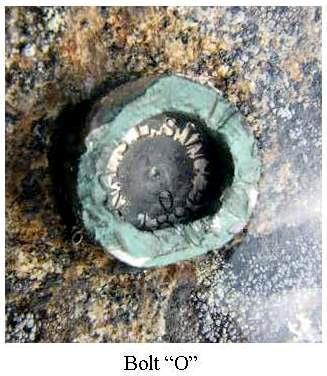
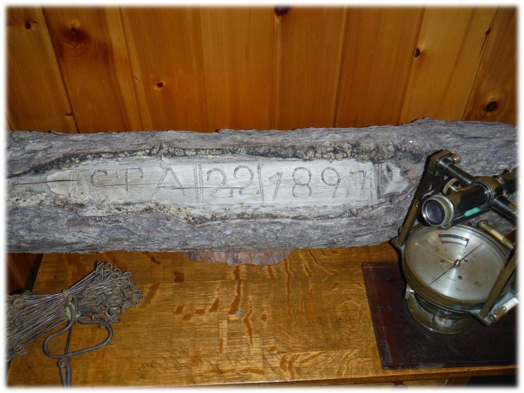
1 Daniel E. Marvin Marvin Land Surveying Lake Placid, NY Why 100 feet measured yesterday may not necessarily equal 100 feet today As Professionals it is Important to Understand the Accuracies in use at the time the Original Survey was done in your Area.
2
3
4

5 Some of these original surveys were made as early as 1768, others in 1772, and a few of the great land patents were actually located subsequently to the year In all cases these original surveys of the interior were made with the crudest instruments and with unknown and unrecorded standards of the linear measurement.
6
7
8


9


10
11

12 Dan s Thoughts
13 The Survey of John s Little Acre By L. M. Powell, L.S., Hamilton, Montana In the beginning, God created Heaven and Earth and the great flood and the Ice Age passed, and there were stone and soil and minerals on John s little acre. In 2500B.C., by a strange mutation, surveyors were created and their work became a profession. At the time, doctors were still rattling bones and chanting to cure their patients, and lawyers were meting out justice on the eye-for-an-eye, tooth-for-a-tooth principle. And each Spring the Nile destroyed the survey markers and they had to be remeasured so taxes could be levied, and trees grew on John s little acre. Years passed and in England, the common law was established and it was good it was horse sense. To fulfill the claim of land ownership, metes and bounds descriptions were prepared such as: Beginning on the bridge cross Spring Creek at the west edge of the town of Devonshire, England; thence north along the center of Spring Creek to the stone fence along Jones south line: thence west along said stone fence to a lone oak tree. and once each year the people of the village walked the property lines and each owner performed a ritual which laid claim to his land, and flowers grew on John s little acre. The compass was invented, the world became round, sailors navigated, America was discovered, the Mayflower sailed, and buffalo grazed on John s little acre. The Colonies were formed and wars were fought; Washington and Lincoln were surveyors; and birds sang on John s little acre. In 1803, the Louisiana Purchase was made which placed a value of 4 cents on John s little acre. The sectionalized system of Land Surveying had been in use for some time when the surveyor entered the Bitterroot Valley in 1872 and determined that Section23, t. 6N., R. 21 W., P.M.M. included John s little acre. And stones were set and witnessed every half mile around Section 23 and the Government said:
14 This is good and proper, and these markers shall govern the perimeter and the aliquot parts of Section 23regardless of errors in the original measurement. and the SW1/4 of Section 23 included John s little acre. In the year 1890 a homestead was patented to a man named Bill which covered the SW1/4 of Section 23, and Bill thought he owned exactly 160 acres bounded by lines bearing due north, south, east and west, but he didn t; the acreage was short and the lines crooked, but, it still included John s little acre. Now John was a friend of Bill s, so when he moved to the Bitterroot Valley in 1895, Bill deeded him an acre of land for his homesite. The two men agreed on the boundaries, paced the distances, and drove buggy axles on the four corners. They then estimated that the SW corner was about 200 yards NE of the SW corner of Section 23, and a point of beginning was established for John s little acre. In 1898 John to get married and mortgaged his acre to acquire funds to improve the house. The bank required a survey of the property, so a man with a compass and chain was hired. Due to the deposit of Iron ore near the SW corner of Section 23, his bearings were erratic, and since the area was brushy, his distances left something to be desired, but the buggy axles were there and still marked the true boundaries of John s little acre. By 1910 the orchard boom was on. The area had been cleared and planted to apple trees. The bearing trees had been cut and the section corner stone covered with soil. An orchard development company had purchased Bill s 160 acres and directed their surveyor to locate the exception which was John s little acre. The surveyor, assuming that the section corner was lost, found the four buggy axles and using the erroneous data from the previous survey, set a pipe to mark the SW corner of Section 23. Using a transit and steel tape, he retraced the angles and distances between the four buggy axles and prepared a new description (the third) for John s little acre. During construction of a county road in 1920, the cornerstone on the
 prepared for John s little")


15 SW corner of Section 23 was found and reset beneath the road surface. In 1921 the four buggy axles were tied to the true section corner and a new description (the fourth) prepared for John s little acre. In 1960 a theodolite was used, and the bearings corrected slightly on John s little acre. In 1970, an electronic measuring device was used and the distances corrected slightly on John s little acre. And so it came to pass that by 1970, John s little acres had numerous descriptions but it had in fact never changed. The true boundaries are still marked by four buggy axles, the bearings and distances bore little resemblance to the original deed, the acreage was actually acres, but it was still John s little acre. from the Conn. Assoc. of L.S., Inc. and from VSLS 1982
Legal Description & Site Plan Requirements and Layouts
 Legal Description & Site Plan Requirements and Layouts Plot Plan * A plot plan shows the location of a house from an aerial view. * The site plan, also known as a plot or lot plan includes: 1. Site plan
Lesson 8: Surveying the Forest
 Lesson 8: Surveying the Forest TEACHER: SCHOOL: GRADE LEVEL: 9-12 TASKS/COMPETENCIES ANR8046.172 Set up and operate a transit level and rod. ANR8046.173 Read a rod and a level to calculate slope. ANR8046.174
Survey Requirements. Design Guidelines and Standards. June Office of the University Architect
 Design Guidelines and Standards Survey Requirements June 2004 Office of the University Architect Construction Management P.O. Box 210181 Cincinnati, Ohio 45221-0181 Table of Contents Survey Requirements
HAMILTON TOWNSHIP Department of Planning and Zoning Application for a Commercial / Industrial Site Plan Review
 HAMILTON TOWNSHIP Department of Planning and Zoning Application for a Commercial / Industrial Site Plan Review Date: Application is hereby made for a Site Plan Review for a commercial or industrial use.
DANE COUNTY ORDINANCE AMENDMENT NO: Internal Tracking Number: RECU25846
 DANE COUNTY ORDINANCE AMENDMENT NO: 10314 Internal Tracking Number: RECU25846 Amending Section 10.03 relating to Zoning Districts in the Town of Cottage Grove. The Dane County Board of Supervisors does
VICINITY MAP SCALE 1'' = 2000'
 LOCATED IN THE SOUTHWEST QUARTER OF SECTION AND THE WEST HALF OF SECTION 4, TOWNSHIP SOUTH, RANGE 68 WEST OF THE 6TH PRINCIPAL MERIDIAN, SHEET OF 5 E47 TOLL ROAD CASE NO. ZAX 26-4 LEGAL DESCRIPTION: A
Beginning Land Platting J. Mark Lowe, CG, FUGA All rights reserved 2017
 Beginning Land Platting J. Mark Lowe, CG, FUGA marklowe@kytnresearch.com All rights reserved 2017 Making a tract map may help a researcher identify a community, including neighbors, ferries, mills, cemeteries,
Section E NSPS MODEL STANDARDS FOR TOPOGRAPHIC SURVEYS Approved 3/12/02
 Section E NSPS MODEL STANDARDS FOR TOPOGRAPHIC SURVEYS Approved 3/12/02 1. INTRODUCTION This standard is written to provide the professional surveyor (Surveyor) and the client with a guideline for producing
7000 Fifteen Mile Road Sterling Heights, Michigan
 7000 Fifteen Mile Road Sterling Heights, Michigan Industrial Building With Excess Land and Rail Access As exclusive agents, we are pleased to offer the following property for lease: 128,648 Sq. Ft. Completely
Location of Structure on Site
 Chapter 1 Location of Structure on Site A number of factors affect the location of a structure on a site, as well as the type of building that may be erected. Once the site is chosen, different methods
Engineering Surveying -1 CE212 Chain Survey
 Engineering Surveying -1 CE212 Chain Survey Lecture 2016, September 26-27 Muhammad Noman Chain Survey Chain survey is the simplest method of surveying. In this survey only measurements are taken in the
12 STEPS TO SHOWING IMPROVEMENTS ON A PLAT
 12 STEPS TO SHOWING IMPROVEMENTS ON A PLAT When you apply for a building permit to do exterior work on your property (such as building an addition or adding a deck), you must include a site or survey drawing
SALE PRICE: $195,750.00
 FOR SALE HWY 27, CRYSTAL SPRINGS, MS 39059 SALE PRICE: $195,750.00 PROPERTY DESCRIPTION PROPERTY OVERVIEW Great recreational property and home site with easy access to Crystal Springs, Utica and Jackson.
Mapping The Study Area
 While on the beach you will need to take some measurements to show where the study area is relative to the rest of the world and to show what is inside the study area. Once the measurements have been taken,
Map Basics: Datums and Coordinate Systems
 Map Basics: Datums and Coordinate Systems ESRM 304 Autumn 2015 Contributors: Phil Hurvitz, Peter Schiess, Eric Turnblom 1 of 39 Datums, land division systems, & coordinate systems Datums (from Wikipedia)
Permit Application. General Information
 Town of Permit Application Application Date: / /20 Permit Type Requested: [ ] New Construction [ ] Expansion [ ] Accessory Building [ ] Reconstruction [ ] Earth Moving [ ] Dock/Deck [ ] Fence [ ] Foundation
SECTION 2 GENERAL REQUIREMENTS
 SECTION 2 GENERAL REQUIREMENTS 2-1 ENGINEER REQUIRED: All plans and specifications for Improvements which are to be accepted for maintenance by the County and private, on-site drainage and grading shall
General Requirements for the Preparation of Plans
 August 6, 2003 General Requirements for the Preparation of Plans NOTE: This document is a Controller of Surveys Policy manual to be used as a general guideline for the preparation and examination of plans.
Example Plans: Business Signs (Not For Construction)
") Plans: Business s Site Plan 220 10 utility easement 120 40 50 Proposed Awning Proposed Freestanding 40 79 20 Street Name Proposed Wall C L N 123 Historic Way Indianapolis, IN 46000 Basic Elements of a
Plans: Business s Site Plan 220 10 utility easement 120 40 50 Proposed Awning Proposed Freestanding 40 79 20 Street Name Proposed Wall C L N 123 Historic Way Indianapolis, IN 46000 Basic Elements of a
201 East Main St Mount Kisco NY $6,350, % CAP. 125 Newtown Rd, Suite 300 Plainview, NY 1180 (516)
") 201 East Main St Mount Kisco NY 10549 INVESTMENT SUMMARY FINANCIAL INFORMATION INVESTMENT HIGHLIGHTS Lease Expiration Annual Rent Increases Options Lease Type Price: October 2024 $ 365,000 5% Every 5 Year
201 East Main St Mount Kisco NY 10549 INVESTMENT SUMMARY FINANCIAL INFORMATION INVESTMENT HIGHLIGHTS Lease Expiration Annual Rent Increases Options Lease Type Price: October 2024 $ 365,000 5% Every 5 Year
MINOR SUBDIVISION. [ ] [ ] [ ] [ ] B. Dimensions, bearings and curve data for all property lines and easements.
![MINOR SUBDIVISION. [ ] [ ] [ ] [ ] B. Dimensions, bearings and curve data for all property lines and easements.](/thumbs/90/102241643.jpg "MINOR SUBDIVISION. [ ] [ ] [ ] [ ] B. Dimensions, bearings and curve data for all property lines and easements.") MINOR SUBDIVISION 190-69. Minor subdivisions. In addition to the requirements indicated in 190-67 (SEE BELOW), the information below shall be shown on the plans for all minor subdivision applications.
MINOR SUBDIVISION 190-69. Minor subdivisions. In addition to the requirements indicated in 190-67 (SEE BELOW), the information below shall be shown on the plans for all minor subdivision applications.
LEHIGH SLATE COMPANY MANTEL FACTORY SLATINGTON, PA
 LEHIGH SLATE COMPANY MANTEL FACTORY SLATINGTON, PA STATEMENT OF HISTORY AND SIGNIFICANCE The purpose of this section is to provide a succinct narrative. Substituting previously printed materials, such
Anne Arundel County Dept. of Inspections and Permits Storm Drain Checklist
 Project Name Project Number Engineer Plans are to be designed based on the standards set forth in the Anne Arundel County Design Manual Standards and Specifications, and all other manuals as stipulated
CHAPTER 11 SURVEY CADD
 CHAPTER 11 SURVEY CADD Chapter Contents Sec. 11.01 Sec. 11.02 Sec. 11.03 Sec. 11.04 Sec. 11.05 Sec. 11.06 Sec. 11.07 Sec. 11.08 Sec. 11.09 Sec. 11.10 General Description of Survey File Contents of Survey
P.L. 1999, CHAPTER 258, approved October 15, 1999 Assembly, No (First Reprint)
") P.L., CHAPTER, approved October, Assembly, No. 0 (First Reprint) 0 0 0 AN ACT concerning the approval and filing of maps and amending P.L.0, c.. BE IT ENACTED by the Senate and General Assembly of the
P.L., CHAPTER, approved October, Assembly, No. 0 (First Reprint) 0 0 0 AN ACT concerning the approval and filing of maps and amending P.L.0, c.. BE IT ENACTED by the Senate and General Assembly of the
Alabama Standards of Practice for Surveying
 PDHonline Course L144 (6 PDH) Alabama Standards of Practice for Surveying Instructor: Jerry Thacker, PLS, P.E. and John C. Huang, Ph.D., P.E. 2012 PDH Online PDH Center 5272 Meadow Estates Drive Fairfax,
Discovery Report Appendix L Dams and Floodplain Structures Lake Ontario St. Lawrence Watershed HUC
 Discovery Report Appendix L Dams and Floodplain Structures Lake Ontario St. Lawrence Watershed HUC 04150309 July 2016 Federal Emergency Management Agency Department of Homeland Security 26 Federal Plaza
701 OCEAN STREET, 4 TH FLOOR, SANTA CRUZ, CA (831) FAX: (831) TDD: (831)
 FAX: (831) TDD: (831)") COUNTY OF SANTA CRUZ 701 OCEAN STREET, 4 TH FLOOR, SANTA CRUZ, CA 95060 (831) 454-2580 FAX: (831) 454-2131 TDD: (831) 454-2123 Measuring Your Structure and Drawing Scaled Plans Applications for building
COUNTY OF SANTA CRUZ 701 OCEAN STREET, 4 TH FLOOR, SANTA CRUZ, CA 95060 (831) 454-2580 FAX: (831) 454-2131 TDD: (831) 454-2123 Measuring Your Structure and Drawing Scaled Plans Applications for building
TOWN OF DOUGLAS EARTH REMOVAL SPECIAL PERMIT APPLICATION FORM Pursuant to Section 6.1 of the Douglas Zoning Bylaw
 I. Owner Information II. Applicant Information III. Representative Information IV. Operator Information er.doc Page 1 of 5 Douglas Planning Board V. Site Information Assessors Map Assessors Parcel Deed
ACWWA DRAWING SUBMITTAL INFORMATION - UTILITY DRAWING REQUIREMENTS
 ACWWA DRAWING SUBMITTAL INFORMATION - UTILITY DRAWING REQUIREMENTS Detailed construction drawings for system extensions shall be prepared for approval with a submittal to the Authority. All construction
DOUBLE PROPORTION MADE COMPLEX
 DOUBLE PROPORTION MADE COMPLEX Jerry L. Wahl Branch of Cadastral Surveys Bureau of Land Management California State Office 2800 Cottage Way, E-2841 Sacramento, California 95825 ABSTRACT Our ever increasing
STATE UNIVERSITY CONSTRUCTION FUND
 DIRECTIVE 1C-12 Issue date: August 2012 1. General SURVEY, MAPPING AND UTILITY LOCATING This Directive has been developed as a general guide for the survey and mapping effort required for Fund projects.
Sturgis/Whitewood, SD 405 +/- acres $1,090,250
 Sturgis/Whitewood, SD 405 +/- acres $1,090,250 The Hefner North Unit is a property that has not been offered for sale in over half a century! This historic offering has benefited from superb land management
Perimeter and Area: The Mysterious Connection Assessment
 Perimeter and Area: The Mysterious Connection Assessment 1. Given the polygon below, which of the following polygons does not have the same perimeter? A. B. C. D. The Mysterious Connection Assessment Materials
Site Plan/Building Permit Review
 Part 6 Site Plan/Building Permit Review 1.6.01 When Site Plan Review Applies 1.6.02 Optional Pre- Application Site Plan/Building Permit Review (hereafter referred to as Site Plan Review) shall be required
1. Land survey Work. 2. Civil and Structural engineering services.
 SECTION 01050 FIELD ENGINEERING PART 1 - GENERAL 1.01 RELATED DOCUMENTS A. Drawings and general provisions of the Contract, including General and Supplementary Conditions and other Division-1 Specification
Requirements for Boundary Line Marking
 Standard Survey Contract Provisions Contractor/Vendor shall not interfere with lawful public hunting and trapping activities. No survey activity shall occur on the opening days of small game season, spring
Area and Perimeter. Practice 1 Area of a Rectangle. Find the area of each figure. Example. one-inch squares.
 Name: Date: Chapter Practice 1 Area of a Rectangle Find the area of each figure. Example There are 3 rows of one-inch squares. Each row has 4 one-inch squares. 3 3 4 5 12 There are 12 one-inch squares
784 (+/-) total acres Desha County, Arkansas. Licensed in Arkansas, Louisiana, Mississippi, Tennessee, and Texas
 total acres Desha County, Arkansas. Licensed in Arkansas, Louisiana, Mississippi, Tennessee, and Texas") offered for sale DELTA RIVERBEND A recreational investment opportunity 784 (+/-) total acres Desha County, Arkansas offered by Licensed in Arkansas, Louisiana, Mississippi, Tennessee, and Texas DISCLOSURE
offered for sale DELTA RIVERBEND A recreational investment opportunity 784 (+/-) total acres Desha County, Arkansas offered by Licensed in Arkansas, Louisiana, Mississippi, Tennessee, and Texas DISCLOSURE
Unit 2: Paleolithic Era to Agricultural Revolution
 Unit 2: Paleolithic Era to Agricultural Revolution Standard(s) of Learning: WHI.2 The student will demonstrate knowledge of early development of humankind from the Paleolithic Era to the agricultural revolution
MILL HILL ARTS VILLAGE
 OWNER CIVIL ENGINEER MACON-BIBB URBAN DEVELOPMENT AUTHORITY ALEX MORRISON, EXECUTIVE DIRECTOR 200 CHERRY STREET, SUITE 300 MACON, GA 31201 OFFICE PHONE : (478) 803-2402 TRIPLE POINT ENGINEERING DAN WALLACE,
CHRIST CHURCH HUNTLEY ANGLICAN CEMETERY 2008 Carp Road
 1 Since 1838 BYLAWS AND PRICE LIST CHRIST CHURCH ANGLICAN PARISH OF HUNTLEY CEMETERY BOARD JANUARY 1, 2014. CHRIST CHURCH HUNTLEY ANGLICAN CEMETERY 2008 Carp Road GENERAL INFORMATION 2 The Christ Church
Tualatin River NWR and Wapato Lake BCS number: 47-37
 Tualatin River NWR and Wapato Lake BCS number: 47-37 ***NOTE: We were unable to determine all necessary information for this site description. If you would like to contribute the needed information to
NOTES ON NARRATION. 1. BREAKWATER A. Built in 1839 B feet across
 NOTES ON NARRATION 1. BREAKWATER A. Built in 1839 B. 3600 feet across NOTES ON NARRATION 2. CHAMP A. Legendary sea monster of Lake Champlain B. SighCngs go back to 1609 C. Samuel D. Champlain has recordings
Fernhill Wetlands BCS number: 47-13
 Fernhill Wetlands BCS number: 47-13 ***NOTE: We were unable to determine all necessary information for this site description. If you would like to contribute the needed information to this description,
Wisconsin Corner Point Identification System January 2006
 Wisconsin Corner Point Identification System January 2006 The Wisconsin Point Identification system was developed by a special committee chaired by Mike Romportl, Oneida County Surveyor in the early 1990
APPLICATION FOR PLANNED UNIT DEVELOPMENT (PUD) DEVELOPMENT PLAN
 DEVELOPMENT PLAN") 209 S. Main Street Marysville, Ohio 43040 Phone: (937) 645-7350 Fax: (937) 645-7351 www.marysvilleohio.org APPLICATION FOR PLANNED UNIT DEVELOPMENT (PUD) DEVELOPMENT PLAN *** IMPORTANT INFORMATION ~ Please
209 S. Main Street Marysville, Ohio 43040 Phone: (937) 645-7350 Fax: (937) 645-7351 www.marysvilleohio.org APPLICATION FOR PLANNED UNIT DEVELOPMENT (PUD) DEVELOPMENT PLAN *** IMPORTANT INFORMATION ~ Please
Brevard County Property Appraiser Titusville Merritt Island Viera Melbourne Palm Bay
 Brevard County Property Appraiser Titusville Merritt Island Viera Melbourne Palm Bay PROPERTY DETAILS Phone: (321) 264-6700 https://www.bcpao.us Account 2709839 Owners Waverly Melbourne LLC 51 John F Kennedy
January 12, 2016 TOWN OF ROXBURY, MAINE. Cemetery Ordinance. ADOPTED ON: March 7 th Town of Roxbury Cemetery Ordinance Page 1
 TOWN OF ROXBURY, MAINE Cemetery Ordinance ADOPTED ON: March 7 th 2016 Town of Roxbury Cemetery Ordinance Page 1 TABLE OF CONTENTS Section 1: Definitions 1 Section 2: Plot Ownership 4 Section 3: Supervising
A. ARTICLE 4 SKETCH PLAN REQUIREMENTS, MAJOR SUBDIVISION AND/OR LAND DEVELOPMENT
 400. 402.A. ARTICLE 4 SKETCH PLAN REQUIREMENTS, MAJOR SUBDIVISION AND/OR LAND DEVELOPMENT SECTION 400 PURPOSE The purpose of the Sketch Plan is to provide an opportunity for the applicant to consult early
Migration- A migration is a long distance movement of animals, especially seasonal movement between wintering and breeding grounds.
 Migration- A migration is a long distance movement of animals, especially seasonal movement between wintering and breeding grounds. Many types of animals migrate including birds, mammals, fish and some
Traffic and Roadway Improvements - Rte 123 (Belmont Street) Brockton, MA Client: BETA Group, Inc.
 Brockton, MA Client: BETA Group, Inc.") HIGHWAY PROJECT EXPERIENCE Traffic and Roadway Improvements - Rte 123 (Belmont Street) Brockton, MA Client: BETA Group, Inc. Alpha provided survey services to prepare a base plan of an approximately 2900
HIGHWAY PROJECT EXPERIENCE Traffic and Roadway Improvements - Rte 123 (Belmont Street) Brockton, MA Client: BETA Group, Inc. Alpha provided survey services to prepare a base plan of an approximately 2900
Page 1 part 1 PART 2
 Page 1 part 1 PART 2 Page 2 Part 1 Part 2 Page 3 part 1 Part 2 Page 4 Page 5 Part 1 10. Which point on the curve y x 2 1 is closest to the point 4,1 11. The point P lies in the first quadrant on the graph
Oakland County Michigan Register of Deeds Plat Engineering, GIS, & Remonumentation Dept. Ph: (248) Fax (248)
 Fax (248)") Oakland County Michigan Register of Deeds Plat Engineering, GIS, & Remonumentation Dept. Ph: (248)-858-1447 Fax (248)-858-7466 Requirements Needed for Final Condominium Approval General Requirements. 1
Oakland County Michigan Register of Deeds Plat Engineering, GIS, & Remonumentation Dept. Ph: (248)-858-1447 Fax (248)-858-7466 Requirements Needed for Final Condominium Approval General Requirements. 1
Salt Lake County (Utah). Planning and Development Services Aerial Photographs, Series #PD-001
. Planning and Development Services Aerial Photographs, Series #PD-001") Salt Lake County (Utah). Planning and Development Services Aerial Photographs, 1946-1979 Series #PD-001 Processed by: Ronda Frazier Date Completed: December, 2008 Updated: October, 2015 Salt Lake County
Salt Lake County (Utah). Planning and Development Services Aerial Photographs, 1946-1979 Series #PD-001 Processed by: Ronda Frazier Date Completed: December, 2008 Updated: October, 2015 Salt Lake County
PRELIMINARY PLAT CHECK LIST
 Name of Proposed Subdivision: The following items must be included with the initial submittal of a Preliminary Plat: Application, filled out completely Project Narrative Pre-application Conference Report
DISASTER PEAK RANCH MCDERMITT, NV
 64347 HARNEY AVE CRANE, OR 3,345 DEEDED ACRES 2,690 ACRES IN OREGON 655 ACRE IN NEVADA 848.3 ACRES WATER RIGHTS DISASTER PEAK RANCH MCDERMITT, NV 7,342 AUMs BLM PERMIT BLM SURROUNDS DEEDED 2 HOMES, CORRALS,
Smith River Mouth BCS number: 86-6
 Smith River Mouth BCS number: 86-6 ***NOTE: We were unable to determine all necessary information for this site description. If you would like to contribute the needed information to this description,
COURSE SYLLABUS SURVEYING I
 Solution Manual for Surveying Fundamentals and Practices 6th Edition by Nathanson Lanzafama Emeritus Link full download: http://testbankcollection.com/download/solution-manual-forsurveying-fundamentals-and-practices-6th-edition-by-nathanson-lanzafamaemeritus/
Ladd Marsh Wildlife Area BCS number: 49-3
 Oregon Coordinated Aquatic Bird Monitoring: Description of Important Aquatic Bird Site Ladd Marsh Wildlife Area BCS number: 49-3 Site description author M. Cathy Nowak, Ladd Marsh Wildlife Area Biologist
PLANNING AND DEVELOPMENT
 OVERVIEW Effective January 1, 1992 all applications for multi-family residential and all non-residential building permits require site plan approval before permit issuance. All new developments and existing
SITE PLAN, SUBDIVISION & EXTERIOR DESIGN REVIEW PROCESS
 INCORPORATED VILLAGE OF ROCKVILLE CENTRE BUILDING DEPARTMENT SITE PLAN, SUBDIVISION & EXTERIOR DESIGN REVIEW PROCESS Presubmission - Prior to a formal submission, the applicant should meet in person with
You may use a calculator. Answer the following questions. (5 pts; partial credit at teacher discretion)
") Pre-Test Unit 7: Pythagorean Theorem KEY You may use a calculator. Answer the following questions. (5 pts; partial credit at teacher discretion) 1. What is the IF-THEN statement for the Pythagorean Theorem?
Pre-Test Unit 7: Pythagorean Theorem KEY You may use a calculator. Answer the following questions. (5 pts; partial credit at teacher discretion) 1. What is the IF-THEN statement for the Pythagorean Theorem?
Maryland Council on Economic Education 1
 Life in Colonial Boston by Jennifer Blizin Gillis. Chicago: Heinemann Library, 2003. ISBN 140344284-3 Literature Annotation: This book describes life in colonial Boston, Massachusetts from 1760-1773. The
Winnipeg and in the western provinces. A combine was set up and demonstrations of the
 "For Sale". This well known sign was displayed a few days ago in front of the plant of the Sylvester Manufacturing Company at Kent and Victoria Aveijue, and thereby hangs a story of one of Lindsay's pioneer
Town of Apex, North Carolina
 POND DRAINAGE PLAN APPLICATION Town of Apex, North Carolina POND DRAINAGE PLAN APPLICATION: Applications are due by 12:00 pm on the first business day of each month. Please see the Minor Site Plan Schedule
Mud Slough Wetland Reserve BCS number: 47-19
 Mud Slough Wetland Reserve BCS number: 47-19 ***NOTE: We were unable to determine all necessary information for this site description. If you would like to contribute the needed information to this description,
AC : THE PEDAGOGY OF THE SURVEYING LABORATORY
 C 2008-724: THE PEDGOGY OF THE URVEYING LBORTORY Philip Brach, University of the District of Columbia PHILIP L. BRCH, PH.D., P.E., F-NPE Distinguished Professor (Emeritus), former Dean, Past President,
APPEARANCES: Stephen D. Hartman, Esq., and Thomas J. Ray, Esq., Carson City, Nevada, for Stoddard Jacobsen; Robert C. Downer, pro se.
 STODDARD JACOBSEN; ROBERT C. DOWNER -762 Decided March 22, 1985 Appeal from a decision of the State Director, Nevada, Bureau of Land Management, dismissing protest of dependent resurvey. Group No. 599.
Warner Wetlands / Warner Valley BCS number: 48-31
 Oregon Coordinated Aquatic Bird Monitoring: Description of Important Aquatic Bird Site Warner Wetlands / Warner Valley BCS number: 48-31 Site description author(s) Vernon Stofleth, Lakeview BLM District
VARIANCE APPLICATION (NO SITE PLAN OR SUBDIVISION)
") VARIANCE APPLICATION (NO SITE PLAN OR SUBDIVISION) 190-66. General procedure for completeness review. A. In order to be determined complete for review by the Board, all of the required information must
VARIANCE APPLICATION (NO SITE PLAN OR SUBDIVISION) 190-66. General procedure for completeness review. A. In order to be determined complete for review by the Board, all of the required information must
Researching Texas Land and Property Records
 Researching Texas Land and Property Records Teri E. Flack, MA, MBA, FTxSGS Land records constitute a major genealogical resource in Texas. There are two primary places to research land and property records
McKay Creek National Wildlife Refuge BCS number: 48-19
 Oregon Coordinated Aquatic Bird Monitoring: Description of Important Aquatic Bird Site McKay Creek National Wildlife Refuge BCS number: 48-19 Site description author(s) Howard Browers, Supervisory Wildlife
Later Log Houses ( )
") Later Log Houses (1885-1905) During the 1880s, as the economy of New Iceland improved, with the development of the fishing industry, a better form of log house appeared. These structures, though remaining
Later Log Houses (1885-1905) During the 1880s, as the economy of New Iceland improved, with the development of the fishing industry, a better form of log house appeared. These structures, though remaining
SUBMITTAL REQUIREMENTS RCV D REJECT PENDING
 1 of 5 SUBMITTAL REQUIREMENTS RCV D REJECT PENDING 1. General Information. 1.1 Applicant s name, address and contact numbers. 1.2 Project name, type, address and legal description of the property. 1.3
PLANNING DEPARTMENT. Measuring Your Vacation Rental and Drawing Scaled Plans
 COUNTY OF SANTA CRUZ PLANNING DEPARTMENT 701 OCEAN STREET - 4 TH FLOOR, SANTA CRUZ, CA 95060 (831) 454-2580 FAX: (831) 454-2131 TDD: (831) 454-2123 KATHLEEN MOLLOY PREVISICH, PLANNING DIRECTOR Measuring
SALE/ LEASE 4760 PORTLAND RD NE. SALEM OR. Offered at $3,800,000 $.90/ SF NNN. Ian Levin, Realtor main:
 SALE/ LEASE class a interior 4760 PORTLAND RD NE. SALEM OR. state certified command center Designated as a Command Center by the State of Oregon. Previously occupied by the Oregon State Fire Marshall,
Charlotte-Mecklenburg Planning Department Review Fees
 Charlotte-Mecklenburg Planning Department Review Fees (Rezoning / Subdivision / Zoning Administration) (July 1, 2010 June 30, 2011) FEES EFFECTIVE JULY 1, 2010 REZONING APPLICATION, CONDITIONAL ZONING
William E. Gladstone Four times Prime Minister of Britain Between
 Show me the manner in which a nation or community cares for its dead and I will measure with mathematical exactness the tender sympathies of its people, their respect for the laws of the land, and their
B.2 MAJOR SUBDIVISION PRELIMINARY PLAN CHECKLIST
 B.2 MAJOR SUBDIVISION PRELIMINARY PLAN CHECKLIST YES* GENERAL SUBMISSION ITEMS Does the submission include: 1. Thirteen (13) copies of completed Application Form? 2. Thirteen (13) copies of the Preliminary
Subdivision Application Checklist
 City of Portsmouth, New Hampshire Subdivision Application Checklist This subdivision application checklist is a tool designed to assist the applicant in the planning process and for preparing the application
Shelley Richards Niagara County Genealogical Society Lockport, NY
 Shelley Richards Niagara County Genealogical Society Lockport, NY June 24, 2009 What is a family history? Why do this? Where do you start? How to organize your work Combines genealogical information ie
CITY OF OLIVETTE SITE PLAN AND COMMUNITY DESIGN REVIEW INFORMATION PACKET
 CITY OF OLIVETTE SITE PLAN AND COMMUNITY DESIGN REVIEW INFORMATION PACKET THE FOLLOWING PACKET CONTAINS: PETITION FOR NONRESIDENTIAL DEVELOPMENT SITE PLAN AND COMMUNITY DESIGN REVIEW SCHEDULE OF DATES
Conceptual, Preliminary and Final Site Plan Review in Holladay City
 Conceptual, Preliminary and Final Site Plan Review in Holladay City The City of Holladay incorporated in December, 1999 and adopted its own zoning ordinance in May, 2000. All land use decisions are made
A Report on the Ground Penetrating Radar Survey 205 Little Plains Road Southampton, NY
 A Report on the Ground Penetrating Radar Survey 205 Little Plains Road Southampton, NY November 18, 2016 Conducted by Robert W. Perry TOPOGRAPHIX, LLC Hudson, NH Requested by Southampton Town Historical
OVERVIEW. Land, Court, and Probate Records for New York State. Class 2. Meet today s presenter 3/30/2017. Presentation (60 mins.) Probate Land Court
 Probate Land Court") Land, Court, and Probate Records for New York State Class 2 David Allen Lambert, Chief Genealogist Meet today s presenter David Allen Lambert Chief Genealogist OVERVIEW Presentation (60 mins.) Probate
Land, Court, and Probate Records for New York State Class 2 David Allen Lambert, Chief Genealogist Meet today s presenter David Allen Lambert Chief Genealogist OVERVIEW Presentation (60 mins.) Probate
Killin Wetland (Cedar Canyon Marsh) BCS number: 47-15
 BCS number: 47-15") Killin Wetland (Cedar Canyon Marsh) BCS number: 47-15 ***NOTE: We were unable to determine all necessary information for this site description. If you would like to contribute the needed information to
Killin Wetland (Cedar Canyon Marsh) BCS number: 47-15 ***NOTE: We were unable to determine all necessary information for this site description. If you would like to contribute the needed information to
Drafting Requirements for the Preparation of Plans
 October 4, 2014 Drafting Requirements for the Preparation of Plans NOTE: This document is a Controller of Surveys Policy manual to be used as a general guideline for the preparation and examination of
Cat Island Chain Restoration Project Brown County Port & Resource Recovery Department
 Cat Island Chain Restoration Project Brown County Port & Resource Recovery Department February 2, 2015 Fox River and Lower Green Bay Cat Island Chain - 1938 Cat Island Brown County Aerial Photography,
MEMORIAL JOHN ELLIOTT TAPPAN
 MEMORIAL FOR JOHN ELLIOTT TAPPAN (August 29, 1870 January 16, 1957) =ooo= Hennepin County Bar Association District Court Minneapolis, Minnesota May 11, 1957 Memorial For JOHN ELLIOTT TAPPAN Member of the
TECHNOLOGICAL IMPROVEMENTS. Era Two: BCE
 TECHNOLOGICAL IMPROVEMENTS Era Two: 4000-1000 BCE 1 THE STORY OF TECHNOLOGY Watch the video clip: http://www.youtube.com/watch?v=vjiluawpe20 Stop and Jot, then Turn and Talk: What does this video make
Wanaket Wildlife Area BCS number: 48-30
 Oregon Coordinated Aquatic Bird Monitoring: Description of Important Aquatic Bird Site Wanaket Wildlife Area BCS number: 48-30 Site description author(s) M. Cathy Nowak, ODFW, Ladd Marsh Wildlife Area
The History of the Black Swamp Nature Center
 The History of the Black Swamp Nature Center 900 FAIRGROUND DRIVE SUITE B, PAULDING, OH 45879 Phone: (419) 399-4771 Email: paulding@pauldingswcd.org www.pauldingswcd.org Ownership of the Black Swamp Nature
BUMPER BETWEEN PAPERS PRACTICE PAPER. SET 3 (of 3) HIGHER Tier (Summer 2017) QUESTIONS. Not A best Guess paper.
 HIGHER Tier (Summer 2017) QUESTIONS. Not A best Guess paper.") BUMPER BETWEEN PAPERS PRACTICE PAPER SET 3 (of 3) HIGHER Tier (Summer 2017) QUESTIONS Not A best Guess paper. Neither is it a prediction... only the examiners know what is going to come up! Fact! You also
BUMPER BETWEEN PAPERS PRACTICE PAPER SET 3 (of 3) HIGHER Tier (Summer 2017) QUESTIONS Not A best Guess paper. Neither is it a prediction... only the examiners know what is going to come up! Fact! You also
Porter County Plan Commission
 Plan Type: Development Plan Administrative DRC PC Primary Plan Administrative DRC PC Secondary Plat/Replat Administrative DRC PC PUD Conceptual Detailed Final Project Information Project Name: Developer
Table of Contents. #2911 Paired Passages 2 Teacher Created Resources, Inc.
 Unit 1 Nonfiction: Why the Dog Barked...8 Fiction: The Hot Dog Mystery...9 Unit 2 Nonfiction: Left on the Moon...12 Fiction: Jumping High...13 Unit 3 Nonfiction: The Not Bears...16 Fiction: Only Pizza....17
Lesson 6.1 Skills Practice
 Lesson 6.1 Skills Practice Name Date Soon You Will Determine the Right Triangle Connection The Pythagorean Theorem Vocabulary Match each definition to its corresponding term. 1. A mathematical statement
AP World History (Povletich) CHAPTER 30 OUTLINE The Making of Industrial Society
 CHAPTER 30 OUTLINE The Making of Industrial Society") AP World History (Povletich) CHAPTER 30 OUTLINE The Making of Industrial Society BACKGROUND KNOWLEDGE: The previous chapter describes the dramatic political changes that followed the American and French
AP World History (Povletich) CHAPTER 30 OUTLINE The Making of Industrial Society BACKGROUND KNOWLEDGE: The previous chapter describes the dramatic political changes that followed the American and French
Feasibility Study To Define Costs & General Conditions For Construction of Improved Entrance Structure
 Feasibility Study To Define Costs & General Conditions For Construction of Improved Entrance Structure From Lake Michigan Into Mona Lake Muskegon County, Michigan Muskegon Chronicle, August 2007 Prepared
Cabaniss Engineering Inc.
 280 North River Church 4215 Rice Mine Road NE -1529 North River Church Subdivision Plat Book 2010, Page 131 Deed Book 550 Page 761 4 18,427 sf 67.7' 5 14,367 sf 60.2' 65.0' 3 13,546 sf 35.2' 6 35' X 277.99