GPS for Route Data Collection. Lisa Aultman-Hall Dept. of Civil & Environmental Engineering University of Connecticut
|
|
|
- Elfrieda Gray
- 5 years ago
- Views:
Transcription
1 GPS for Route Data Collection Lisa Aultman-Hall Dept. of Civil & Environmental Engineering University of Connecticut
2 Acknowledgements Reema Kundu and Eric Jackson University of Kentucky Wael ElDessouki and Jianhe Du University of Connecticut with helpful advice from Jean Wolf, Sean Doherty and Martin Lee Gosselin Aultman-Hall - August 2001
3 Research Interest Route Choice Behavior NOT how people should route (generating optimal routing) what motivations (particularly beyond travel time) affect routing scenery, traffic control, road type, congestion, turns population segmentation Aultman-Hall - August 2001
4 Who Cares? measure benefits of ITS such as route guidance and traveler info systems dissaggregate exposure for crash and safety analysis improve traffic assignment models Aultman-Hall - August 2001
5 Underlying Assumption all drivers seek to minimize their own travel time stochastic algorithms account for variation Aultman-Hall - August 2001
6 Aultman-Hall - August 2001 Travel Route Data
7 Wide-spread route data is now within reach computer power and memory Geographic Information Systems (GIS) Global Positioning Systems (GPS) Aultman-Hall - August 2001
8
9
10 Satellites and receivers are synchronized so they generate the same code at the same time. Receivers know the satellite orbits. Product of time difference and speed of light is distance.
11
12 But We have more than one satellite overhead
13
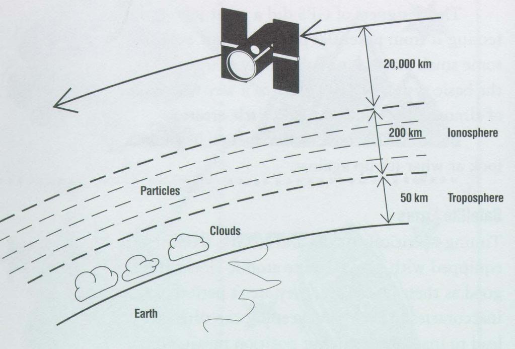
14 Typical Errors satellite clock ephemeris receiver atmosphere multipath S/A 2 feet 2 feet 4 feet 12 feet? up to 25 feet Multiply these values by PDOP to get the real time position accuracy. Good PDOP s range from 4 to 6. Aultman-Hall - August 2001
15 Vehicle + GPS Receiver fleet location and management in-vehicle navigation route data!!! Aultman-Hall - August 2001
16 A Model to Map GPS Data to Networks Aultman-Hall - August 2001
17 A Model to Map GPS Data to Networks Aultman-Hall - August 2001
18 Representation of Networks network accuracy center line representation
19 Urban Canyons / Moving Vehicle Aultman-Hall - August 2001
20 Algorithm Development GPS points link route data route choice models traffic line network Optimal GPS Settings PDOP filter noise to signal ratio frequency
21 Aultman-Hall - August 2001 Lexington, KY Population 250, Square Miles 1350 miles road
22
23 Route Development all road types turns downtown rural and treed areas some aimed to trick do NOT start and end at nodes Aultman-Hall - August 2001
24
25 Sample Routes
26 Sample Routes
27 Route Dataset 674 routes (18 driven multiple times) average 11.9 miles long maximum PDOP (6,8 & 10) NSR (2,4 & 6) log frequency (1 s, 2 s, 25 ft 50 ft) Aultman-Hall - August 2001
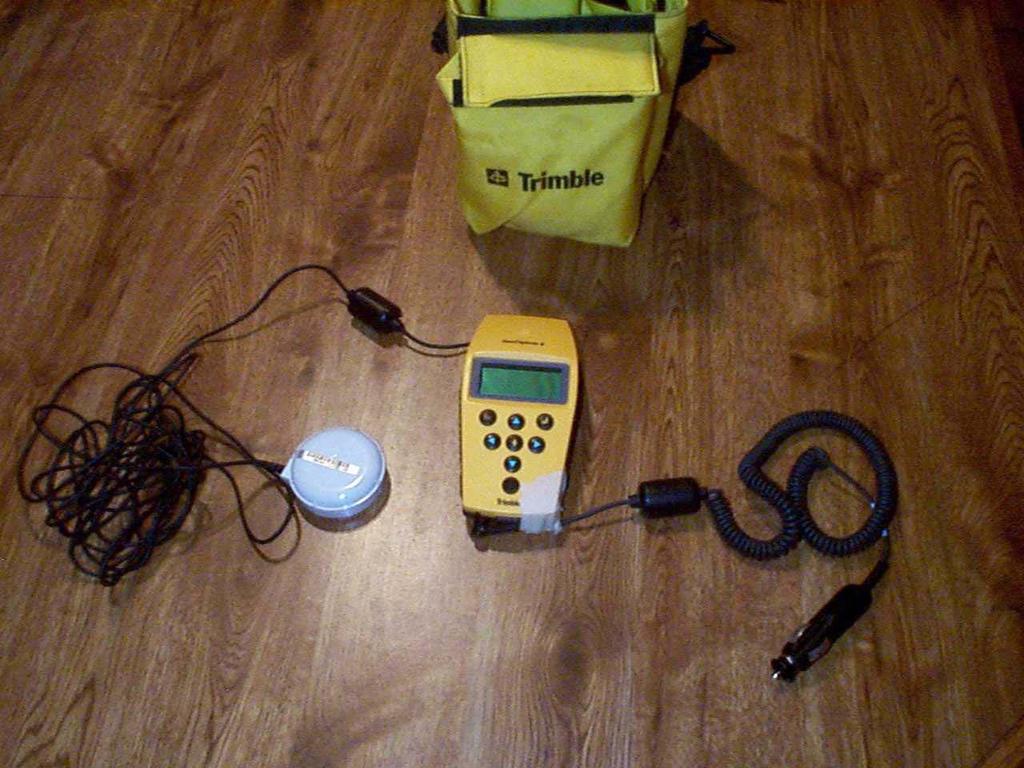
28 Research Procedure TRIMBLE GPS Receivers Office Pathfinder UNIX ArcInfo - find start and end nodes - use GPS points to adjust link impedances - use MPA to generate route PC ArcView for analysis
29 Start and End Nodes
30 Start and End Nodes A B
31 Start and End Nodes B
32 Start and End Nodes 35% start and end nodes both right 60% one or other at wrong end of link 2% wrong due to time lag in GPS starting to record points Aultman-Hall - August 2001
33 Start and End Nodes A B
34 Start and End Nodes PDOP, NSR and logging did not affect success rate still to come - change buffer size and seek improvement GPS points themselves as stops Aultman-Hall - August 2001
35 Route Prediction algorithm gets all cases of 16 of 18 of the routes (when start and end nodes correct) approximately 90% correct Aultman-Hall - August 2001
36 Problematic Route 1
37 Problematic Route 1
38 Problematic Route 2
39 Outstanding Issues start / end missed travel buffer size use inverse of point density as impedance how low can we go on logging frequency
40 Routing Behavior
41 Conclusions disaggregate route data collection via GPS is feasible using a MPA to translate the points to network nomenclature is very successful a method to quantify route variation is needed Aultman-Hall - August 2001
Comparison of Simulation-Based Dynamic Traffic Assignment Approaches for Planning and Operations Management
 Comparison of Simulation-Based Dynamic Traffic Assignment Approaches for Planning and Operations Management Ramachandran Balakrishna Daniel Morgan Qi Yang Howard Slavin Caliper Corporation 4 th TRB Conference
What is a GPS How does GPS work? GPS Segments GPS P osition Position Position Accuracy Accuracy Accuracy GPS A pplications Applications Applications
 What is GPS? What is a GPS How does GPS work? GPS Segments GPS Position Accuracy GPS Applications What is GPS? The Global Positioning System (GPS) is a precise worldwide radio-navigation system, and consists
Link and Link Impedance 2018/02/13. VECTOR DATA ANALYSIS Network Analysis TYPES OF OPERATIONS
 VECTOR DATA ANALYSIS Network Analysis A network is a system of linear features that has the appropriate attributes for the flow of objects. A network is typically topology-based: lines (arcs) meet at intersections
GLOBAL POSITIONING SYSTEMS. Knowing where and when
 GLOBAL POSITIONING SYSTEMS Knowing where and when Overview Continuous position fixes Worldwide coverage Latitude/Longitude/Height Centimeter accuracy Accurate time Feasibility studies begun in 1960 s.
36. Global Positioning System
 36. Introduction to the Global Positioning System (GPS) Why do we need GPS? Position: a basic need safe sea travel, crowed skies, resource management, legal questions Positioning: a challenging job local
GLOBAL POSITIONING SYSTEMS
 GLOBAL POSITIONING SYSTEMS Maps & Geospatial Concepts Fall 2015 Before GPS Historical look at navigation Giant concrete arrows that point your way across America What are these giant arrows? Some kind
Addressing Issues with GPS Data Accuracy and Position Update Rate for Field Traffic Studies
 Addressing Issues with GPS Data Accuracy and Position Update Rate for Field Traffic Studies THIS FEATURE VALIDATES INTRODUCTION Global positioning system (GPS) technologies have provided promising tools
Connected Car Networking
 Connected Car Networking Teng Yang, Francis Wolff and Christos Papachristou Electrical Engineering and Computer Science Case Western Reserve University Cleveland, Ohio Outline Motivation Connected Car
Modeling route choice using aggregate models
 Modeling route choice using aggregate models Evanthia Kazagli Michel Bierlaire Transport and Mobility Laboratory School of Architecture, Civil and Environmental Engineering École Polytechnique Fédérale
Introduction to NAVSTAR GPS
 Introduction to NAVSTAR GPS Charlie Leonard, 1999 (revised 2001, 2002) The History of GPS Feasibility studies begun in 1960 s. Pentagon appropriates funding in 1973. First satellite launched in 1978. System
Primer on GPS Operations
 MP Rugged Wireless Modem Primer on GPS Operations 2130313 Rev 1.0 Cover illustration by Emma Jantz-Lee (age 11). An Introduction to GPS This primer is intended to provide the foundation for understanding
Appendix D Brief GPS Overview
 Appendix D Brief GPS Overview Global Positioning System (GPS) Theory What is GPS? The Global Positioning System (GPS) is a satellite-based navigation system, providing position information, accurate to
Designing Service Coverage and Measuring Accessibility and Serviceability
 Designing Service Coverage and Measuring Accessibility and Serviceability INFORMS Annual Meeting San Francisco, CA November 9-12, 2014 EunSu Lee, Ph.D., GISP, CPIM, CSCP Agenda Introduction Objectives
GPS: The Basics. Darrell R. Dean, Jr. Civil and Environmental Engineering West Virginia University. Expected Learning Outcomes for GPS
 GPS: The Basics Darrell R. Dean, Jr. Civil and Environmental Engineering West Virginia University Expected Learning Outcomes for GPS Explain the acronym GPS Name 3 important tdt dates in history of GPS
Introduction to the Global Positioning System
 GPS for Fire Management - 2004 Introduction to the Global Positioning System Pre-Work Pre-Work Objectives Describe at least three sources of GPS signal error, and identify ways to mitigate or reduce those
GPS positioning using map-matching algorithms, drive restriction information and road network connectivity
 Extended abstract Submission for GISRUK 2001 GPS positioning using map-matching algorithms, drive restriction information and road network connectivity George Taylor 1, Jamie Uff 2 and Adil Al-Hamadani
Lecture 8: GIS Data Error & GPS Technology
 Lecture 8: GIS Data Error & GPS Technology A. Introduction We have spent the beginning of this class discussing some basic information regarding GIS technology. Now that you have a grasp of the basic terminology
Using GPS in Embedded Applications Pascal Stang Stanford University - EE281 November 28, 2000
 Using GPS in Embedded Applications Pascal Stang Stanford University - EE281 INTRODUCTION Brief history of GPS Transit System NavStar (what we now call GPS) Started development in 1973 First four satellites
Introduction to the Global Positioning System
 GPS for ICS - 2003 Introduction to the Global Positioning System Pre-Work Pre-Work Objectives Describe at least three sources of GPS signal error, and ways to mitigate or reduce those errors. Identify
GPS Tutorial Trimble Home > GPS Tutorial > How GPS works? > Triangulating
 http://www.trimble.com/gps/howgps-triangulating.shtml Page 1 of 3 Trimble Worldwide Popula PRODUCTS & SOLUTIONS SUPPORT & TRAINING ABOUT TRIMBLE INVESTORS GPS Tutorial Trimble Home > GPS Tutorial > How
Introduction to Geographic Information Science. Last Lecture. Today s Outline. Geography 4103 / GNSS/GPS Technology
 Geography 4103 / 5103 Introduction to Geographic Information Science GNSS/GPS Technology Last Lecture Geoids Ellipsoid Datum Projection Basics Today s Outline GNSS technology How satellite based navigation
Global Positioning Systems (GPS) Trails: the achilles heel of mapping from the air / satellites
 Trails: the achilles heel of mapping from the air / satellites") Global Positioning Systems (GPS) Trails: the achilles heel of mapping from the air / satellites Google maps updated regularly by local users using GPS Also: http://openstreetmaps.org GPS applications
Global Positioning Systems (GPS) Trails: the achilles heel of mapping from the air / satellites Google maps updated regularly by local users using GPS Also: http://openstreetmaps.org GPS applications
LOCALIZATION WITH GPS UNAVAILABLE
 LOCALIZATION WITH GPS UNAVAILABLE ARES SWIEE MEETING - ROME, SEPT. 26 2014 TOR VERGATA UNIVERSITY Summary Introduction Technology State of art Application Scenarios vs. Technology Advanced Research in
NR402 GIS Applications in Natural Resources
 NR402 GIS Applications in Natural Resources Lesson 5 GPS/GIS integration Global Positioning System (GPS)..a global navigation system that everyone can use What is GPS? How does it work? How accurate is
Feasibility Studies of Time Synchronization Using GNSS Receivers in Vehicle to Vehicle Communications. Queensland University of Technology
 Feasibility Studies of Time Synchronization Using GNSS Receivers in Vehicle to Vehicle Communications Khondokar Fida Hasan Professor Yanming Feng Professor Glen Tian Queensland University of Technology
Aimsun Next User's Manual
 Aimsun Next User's Manual 1. A quick guide to the new features available in Aimsun Next 8.3 1. Introduction 2. Aimsun Next 8.3 Highlights 3. Outputs 4. Traffic management 5. Microscopic simulator 6. Mesoscopic
All you wanted to know about High Accuracy Data Collection Eric Muncy Precision Products Mapping-GIS Division
 All you wanted to know about High Accuracy Data Collection Eric Muncy Precision Products Mapping-GIS Division Tell me your name What School / Organization Any experience with GPS equipment What would you
Large-scale, high-fidelity dynamic traffic assignment: framework and real-world case studies
 Available online at www.sciencedirect.com ScienceDirect Transportation Research Procedia 25C (2017) 1290 1299 www.elsevier.com/locate/procedia World Conference on Transport Research - WCTR 2016 Shanghai.
GPS Accuracy Comparison. Tom Biernacki Florida Department of Environmental Protection
 GPS Accuracy Comparison Tom Biernacki Florida Department of Environmental Protection What Effects the accuracy of GPS? Atmospheric delay Multipath bounce Weak receiver algorithms Atmospheric Delay Signal
Sources of Geographic Information
 Sources of Geographic Information Data properties: Spatial data, i.e. data that are associated with geographic locations Data format: digital (analog data for traditional paper maps) Data Inputs: sampled
An ArcGIS analysis of Stand-alone GPS quality for Road Pricing
 An ArcGIS analysis of Stand-alone GPS quality for Road Pricing Martina Zabic M.Sc., Centre for Traffic & Transport, Technical University of Denmark. Abstract The paper presents the methods and some of
Trimble GNSS Infrastructure
 Trimble GNSS Infrastructure A History of Innovation Trimble, the first company to offer commercial GPS products company to integrate GPS with communications technology RTK system in the market in 1994
GEO 428: DEMs from GPS, Imagery, & Lidar Tuesday, September 11
 GEO 428: DEMs from GPS, Imagery, & Lidar Tuesday, September 11 Global Positioning Systems GPS is a technology that provides Location coordinates Elevation For any location with a decent view of the sky
Location Tracking. Current Technologies 1/19/2011. Not one, single technology Convergence of several technologies. Systems for
 Don Mason Associate Director Copyright 2011 National Center for Justice and the Rule of Law All Rights Reserved Location Tracking Not one, single technology Convergence of several technologies Systems
GPS: What do I need to collect Application Appropriate location data?
 GPS: What do I need to collect Application Appropriate location data? Bob Goodwin, GISP GIS/Remote Sensing Analyst Remote Sensing & GIS Research and Outreach Services, MSU http://www.rsgis.msu.edu 2005
Errors in GPS. Errors in GPS. Geodetic Co-ordinate system. R. Khosla Fall Semester
 Errors in GPS Errors in GPS GPS is currently the most accurate positioning system available globally. Although we are talking about extreme precision and measuring distances by speed of light, yet there
PRINCIPLES AND FUNCTIONING OF GPS/ DGPS /ETS ER A. K. ATABUDHI, ORSAC
 PRINCIPLES AND FUNCTIONING OF GPS/ DGPS /ETS ER A. K. ATABUDHI, ORSAC GPS GPS, which stands for Global Positioning System, is the only system today able to show you your exact position on the Earth anytime,
Indian GNSS Industry Overview Challenges and future prospects
 Indian GNSS Industry Overview Challenges and future prospects Expert Presentation By Dr. S.V. Kibe Consultant, SATCOM & GNSS, Bangalore, India (Former Programme Director, SATNAV,ISRO HQ) On February 20,2013
V2X-Locate Positioning System Whitepaper
 V2X-Locate Positioning System Whitepaper November 8, 2017 www.cohdawireless.com 1 Introduction The most important piece of information any autonomous system must know is its position in the world. This
GEOGRAPHIC INFORMATION SYSTEMS Lecture 22: Field Mapping with GPS
 GEOGRAPHIC INFORMATION SYSTEMS Lecture 22: Field Mapping with GPS GPS Receivers - there are many GPS receivers on the market today - some receivers are relatively inexpensive (recreational grade receivers)
Coarse-time Positioning without Continuous GPS Signal Tracking
 International Global Navigation Satellite Systems Association IGNSS Conference 2016 Colombo Theatres, Kensington Campus, UNSW Australia 6 8 December 2016 Coarse-time Positioning without Continuous GPS
What is it? History. Other systems. How does it work? Trilateration GEOG 201 4/28/2010. Instructor: Pesses 1. {06} The Global Positioning System
 What is it? {06} The Global Positioning System G.P.S. = Global Positioning System Different from G.I.S. (Geographic Information Systems) Map Interpretation & GPS Spring 2010 M. Pesses History Conceived
Roadside Range Sensors for Intersection Decision Support
 Roadside Range Sensors for Intersection Decision Support Arvind Menon, Alec Gorjestani, Craig Shankwitz and Max Donath, Member, IEEE Abstract The Intelligent Transportation Institute at the University
Travel time uncertainty and network models
 Travel time uncertainty and network models CE 392C TRAVEL TIME UNCERTAINTY One major assumption throughout the semester is that travel times can be predicted exactly and are the same every day. C = 25.87321
GPS (Introduction) References. Terms
 References. Terms") GPS (Introduction) WCOM2, GPS, 1 Terms NAVSTAR GPS ( Navigational Satellite Timing and Ranging - Global Positioning System) is a GNSS (Global Navigation Satellite System), developed by the US-DoD in 197x
GPS (Introduction) WCOM2, GPS, 1 Terms NAVSTAR GPS ( Navigational Satellite Timing and Ranging - Global Positioning System) is a GNSS (Global Navigation Satellite System), developed by the US-DoD in 197x
ENGRG Introduction to GIS
 ENGRG 59910 Introduction to GIS Michael Piasecki December 01, 2017 Lecture 12: GPS Systems Lecture 7: Introduction To GPS November 27, 2017 ENGRG 59910 Intro to GIS 2 November 27, 2017 ENGRG 59910 Intro
GPS Errors. Figure 1. Four satellites are required to determine a GPS position.
 Expl ai ni nggps:thegl obalposi t i oni ngsyst em since a minimum of four satellites is required to calculate a position (Fig 1). However, many newer GPS receivers are equipped to receive up to 12 satellite
Empirical Path Loss Models
 Empirical Path Loss Models 1 Free space and direct plus reflected path loss 2 Hata model 3 Lee model 4 Other models 5 Examples Levis, Johnson, Teixeira (ESL/OSU) Radiowave Propagation August 17, 2018 1
GE 113 REMOTE SENSING
 GE 113 REMOTE SENSING Topic 9. Introduction to Global Positioning Systems (GPS) and Other GNSS Technologies Lecturer: Engr. Jojene R. Santillan jrsantillan@carsu.edu.ph Division of Geodetic Engineering
Characteristics of Routes in a Road Traffic Assignment
 Characteristics of Routes in a Road Traffic Assignment by David Boyce Northwestern University, Evanston, IL Hillel Bar-Gera Ben-Gurion University of the Negev, Israel at the PTV Vision Users Group Meeting
Effect of Quasi Zenith Satellite (QZS) on GPS Positioning
 on GPS Positioning") Effect of Quasi Zenith Satellite (QZS) on GPS ing Tomoji Takasu 1, Takuji Ebinuma 2, and Akio Yasuda 3 Laboratory of Satellite Navigation, Tokyo University of Marine Science and Technology 1 (Tel: +81-5245-7365,
Effect of Quasi Zenith Satellite (QZS) on GPS ing Tomoji Takasu 1, Takuji Ebinuma 2, and Akio Yasuda 3 Laboratory of Satellite Navigation, Tokyo University of Marine Science and Technology 1 (Tel: +81-5245-7365,
Positioning, location data and GNSS as solution for Autonomous driving
 Positioning, location data and GNSS as solution for Autonomous driving Jarkko Koskinen, Heidi Kuusniemi, Juha Hyyppä, Sarang Thombre and Martti Kirkko-Jaakkola FGI, NLS Definition of the Arctic 66 34 N
1.1 Students know how to use maps, globes, and other geographic tools to acquire, process, and report information from a spatial perspective.
 Prentice Hall World Geography: Building a Global Perspective 2005 Colorado Model Academic Standards for Social Studies: Geography (Grades 9-12) GEOGRAPHY STANDARD 1: Students know how to use and construct
Digital Surveillance Devices?
 Technology Framework Tracking Technologies Don Mason Associate Director Digital Surveillance Devices? Digital Surveillance Devices? Secure Continuous Remote Alcohol Monitor SCRAM Page 1 Location Tracking
UTILIZATION OF AN IEEE 1588 TIMING REFERENCE SOURCE IN THE inet RF TRANSCEIVER
 UTILIZATION OF AN IEEE 1588 TIMING REFERENCE SOURCE IN THE inet RF TRANSCEIVER Dr. Cheng Lu, Chief Communications System Engineer John Roach, Vice President, Network Products Division Dr. George Sasvari,
Data collection and modeling for APTS and ATIS under Indian conditions - Challenges and Solutions
 Data collection and modeling for APTS and ATIS under Indian conditions - Challenges and Solutions Lelitha Vanajakshi Dept. of Civil Engg. IIT Madras, India lelitha@iitm.ac.in Outline Introduction Automated
Digital surveillance devices?
 Technology Framework Tracking Technologies Don Mason Associate Director Copyright 2011 National Center for Justice and the Rule of Law All Rights Reserved Digital surveillance devices? Digital surveillance
UNIT 1 - introduction to GPS
 UNIT 1 - introduction to GPS 1. GPS SIGNAL Each GPS satellite transmit two signal for positioning purposes: L1 signal (carrier frequency of 1,575.42 MHz). Modulated onto the L1 carrier are two pseudorandom
MOBILITY RESEARCH NEEDS FROM THE GOVERNMENT PERSPECTIVE
 MOBILITY RESEARCH NEEDS FROM THE GOVERNMENT PERSPECTIVE First Annual 2018 National Mobility Summit of US DOT University Transportation Centers (UTC) April 12, 2018 Washington, DC Research Areas Cooperative
Deployment and Testing of Optimized Autonomous and Connected Vehicle Trajectories at a Closed- Course Signalized Intersection
 Deployment and Testing of Optimized Autonomous and Connected Vehicle Trajectories at a Closed- Course Signalized Intersection Clark Letter*, Lily Elefteriadou, Mahmoud Pourmehrab, Aschkan Omidvar Civil
Using GNSS Technology to Accurately Bring Field Information Into GIS. Daniel J. Yaw Jr.
 Using GNSS Technology to Accurately Bring Field Information Into GIS Daniel J. Yaw Jr. About the Presenter Responsible for the upkeep and coordination of GIS and GNSS initiatives 550+ miles of active water
NovAtel s. Performance Analysis October Abstract. SPAN on OEM6. SPAN on OEM6. Enhancements
 NovAtel s SPAN on OEM6 Performance Analysis October 2012 Abstract SPAN, NovAtel s GNSS/INS solution, is now available on the OEM6 receiver platform. In addition to rapid GNSS signal reacquisition performance,
Understanding GPS: Principles and Applications Second Edition
 Understanding GPS: Principles and Applications Second Edition Elliott Kaplan and Christopher Hegarty ISBN 1-58053-894-0 Approx. 680 pages Navtech Part #1024 This thoroughly updated second edition of an
GNSS 101 Bringing It Down To Earth
 GNSS 101 Bringing It Down To Earth Steve Richter Frontier Precision, Inc. UTM County Coordinates NGVD 29 State Plane Datums Scale Factors Projections Session Agenda GNSS History & Basic Theory Coordinate
Understanding GPS/GNSS
 Understanding GPS/GNSS Principles and Applications Third Edition Contents Preface to the Third Edition Third Edition Acknowledgments xix xxi CHAPTER 1 Introduction 1 1.1 Introduction 1 1.2 GNSS Overview
Vehicle routing problems with road-network information
 50 Dominique Feillet Mines Saint-Etienne and LIMOS, CMP Georges Charpak, F-13541 Gardanne, France Vehicle routing problems with road-network information ORBEL - Liège, February 1, 2018 Vehicle Routing
How is GPS Used in Farming? Equipment Guidance Systems
 GPS Applications in Crop Production John Nowatzki, Extension Geospatial Specialist, Vern Hofman, Extension Ag Engineer Lowell Disrud, Assistant Professor, Kraig Nelson, Graduate Student Introduction The
ENTERPRISE Transportation Pooled Fund Study TPF-5 (231)
") ENTERPRISE Transportation Pooled Fund Study TPF-5 (231) Impacts of Traveler Information on the Overall Network FINAL REPORT Prepared by September 2012 i 1. Report No. ENT-2012-2 2. Government Accession
ENTERPRISE Transportation Pooled Fund Study TPF-5 (231) Impacts of Traveler Information on the Overall Network FINAL REPORT Prepared by September 2012 i 1. Report No. ENT-2012-2 2. Government Accession
GLOBAL POSITIONING SYSTEM SHIPBORNE REFERENCE SYSTEM
 GLOBAL POSITIONING SYSTEM SHIPBORNE REFERENCE SYSTEM James R. Clynch Department of Oceanography Naval Postgraduate School Monterey, CA 93943 phone: (408) 656-3268, voice-mail: (408) 656-2712, e-mail: clynch@nps.navy.mil
Location, Location, Location
 Location, Location, Location Larry Rudolph 1 Outline Positioning Technology GPS and others Location Specifiers Privacy Issues Universal Location On earth, we need three piece of information: latitude,
Introduction. Global Positioning System. GPS - Intro. Space Segment. GPS - Intro. Space Segment - Contd..
 Introduction Global Positioning System Prof. D. Nagesh Kumar Dept. of Civil Engg., IISc, Bangalore 560 012, India URL: http://www.civil.iisc.ernet.in/~nagesh GPS is funded and controlled by U. S. Department
Mobile Positioning in Wireless Mobile Networks
 Mobile Positioning in Wireless Mobile Networks Peter Brída Department of Telecommunications and Multimedia Faculty of Electrical Engineering University of Žilina SLOVAKIA Outline Why Mobile Positioning?
Implementing Dijkstra s algorithm for vehicle tracking in adverse geographical condition.
 Implementing Dijkstra s algorithm for vehicle tracking in adverse geographical condition. Sayli Aniruddha Patil Juita Tushar Raut Manasi Nitant Vaity Asst. Professor(Dept. of I.T), Asst. Professor(Dept.
Road Traffic Estimation from Multiple GPS Data Using Incremental Weighted Update
 Road Traffic Estimation from Multiple GPS Data Using Incremental Weighted Update S. Sananmongkhonchai 1, P. Tangamchit 1, and P. Pongpaibool 2 1 King Mongkut s University of Technology Thonburi, Bangkok,
Surface Contents Author Index
 Angelina HO & Zhilin LI Surface Contents Author Index DESIGN OF DYNAMIC MAPS FOR LAND VEHICLE NAVIGATION Angelina HO, Zhilin LI* Dept. of Land Surveying and Geo-Informatics, The Hong Kong Polytechnic University
MGA Webinar Series : 1 Very Cheap RTK Receivers: Changing the Landscape of Positioning Services
 MGA Webinar Series : 1 Very Cheap RTK Receivers: Changing the Landscape of Positioning Services Dinesh Manandhar Center for Spatial Information Science The University of Tokyo Contact Information: dinesh@iis.u-tokyo.ac.jp
The topic we are going to see in this unit, the global positioning system, is not directly related with the computer networks we use everyday, but it
 The topic we are going to see in this unit, the global positioning system, is not directly related with the computer networks we use everyday, but it is indeed a kind of computer network, as the specialised
Carrier Phase GPS Augmentation Using Laser Scanners and Using Low Earth Orbiting Satellites
 Carrier Phase GPS Augmentation Using Laser Scanners and Using Low Earth Orbiting Satellites Colloquium on Satellite Navigation at TU München Mathieu Joerger December 15 th 2009 1 Navigation using Carrier
NGA s Support for Positioning and Navigation
 NGA s Support for Positioning and Navigation PNT Symposium 6 November 2007 Barbara Wiley NATIONAL GEOSPATIAL-INTELLIGENCE AGENCY What is NGA and What Do We Do? National Geospatial-Intelligence Agency (NGA)
Digital Land Surveying and Mapping (DLS and M) Dr. Jayanta Kumar Ghosh Department of Civil Engineering Indian Institute of Technology, Roorkee
 Dr. Jayanta Kumar Ghosh Department of Civil Engineering Indian Institute of Technology, Roorkee") Digital Land Surveying and Mapping (DLS and M) Dr. Jayanta Kumar Ghosh Department of Civil Engineering Indian Institute of Technology, Roorkee Lecture 11 Errors in GPS Observables Welcome students. Lesson
Digital Land Surveying and Mapping (DLS and M) Dr. Jayanta Kumar Ghosh Department of Civil Engineering Indian Institute of Technology, Roorkee Lecture 11 Errors in GPS Observables Welcome students. Lesson
GNSS Training for ITS Developers. Characterisation of EGNSS performances in relationship with the application requirements
 GNSS Training for ITS Developers Characterisation of EGNSS performances in relationship with the application requirements Table of Content egnss for Application: Main Challenges EGNOS and GALILEO Performances
The Wide Area Augmentation System
 The Wide Area Augmentation System Stanford University http://waas.stanford.edu What is Augmentation? 2 Add to GNSS to Enhance Service Improve integrity via real time monitoring Improve availability and
Global Navigation Satellite System (GNSS) for Disaster Mitigation
 for Disaster Mitigation") Global Navigation Satellite System (GNSS) for Disaster Mitigation By Chathura H. Wickramasinghe Geoinformatics Center Asian Institute of Technology Establish in 1959 as a Post Graduate School Catering
Global Navigation Satellite System (GNSS) for Disaster Mitigation By Chathura H. Wickramasinghe Geoinformatics Center Asian Institute of Technology Establish in 1959 as a Post Graduate School Catering
Robust Positioning for Urban Traffic
 Robust Positioning for Urban Traffic Motivations and Activity plan for the WG 4.1.4 Dr. Laura Ruotsalainen Research Manager, Department of Navigation and positioning Finnish Geospatial Research Institute
An Assessment of Mapping Functions for VTEC Estimation using Measurements of Low Latitude Dual Frequency GPS Receiver
 An Assessment of Mapping Functions for VTEC Estimation using Measurements of Low Latitude Dual Frequency GPS Receiver Mrs. K. Durga Rao 1 Asst. Prof. Dr. L.B.College of Engg. for Women, Visakhapatnam,
On-site Traffic Accident Detection with Both Social Media and Traffic Data
 On-site Traffic Accident Detection with Both Social Media and Traffic Data Zhenhua Zhang Civil, Structural and Environmental Engineering University at Buffalo, The State University of New York, Buffalo,
Foreword by Glen Gibbons About this book Acknowledgments List of abbreviations and acronyms List of definitions
 Table of Foreword by Glen Gibbons About this book Acknowledgments List of abbreviations and acronyms List of definitions page xiii xix xx xxi xxv Part I GNSS: orbits, signals, and methods 1 GNSS ground
What is GPS? GPS Position Accuracy. GPS Applications. What is a GPS. How does GPS work? GPS Segments
 What is GPS? What is a GPS How does GPS work? GPS Segments GPS Position Accuracy GPS Applications 1 What is GPS? The Global Positioning System (GPS) is a precise worldwide radio-navigation system, and
Proceedings of Al-Azhar Engineering 7 th International Conference Cairo, April 7-10, 2003.
 Proceedings of Al-Azhar Engineering 7 th International Conference Cairo, April 7-10, 2003. MODERNIZATION PLAN OF GPS IN 21 st CENTURY AND ITS IMPACTS ON SURVEYING APPLICATIONS G. M. Dawod Survey Research
RECOMMENDATION ITU-R BS
 Rec. ITU-R BS.1350-1 1 RECOMMENDATION ITU-R BS.1350-1 SYSTEMS REQUIREMENTS FOR MULTIPLEXING (FM) SOUND BROADCASTING WITH A SUB-CARRIER DATA CHANNEL HAVING A RELATIVELY LARGE TRANSMISSION CAPACITY FOR STATIONARY
GLOBAL POSITIONING SYSTEMS
 GLOBAL POSITIONING SYSTEMS GPS & GIS Fall 2017 Global Positioning Systems GPS is a general term for the navigation system consisting of 24-32 satellites orbiting the Earth, broadcasting data that allows
Introduction. phones etc. Those help to deliver services and improve the quality of life (Desai, 2010).
.") Introduction Information and Communications Technology (ICT) is any application or communication devices such as: satellite systems, computer and network hardware and software systems, mobile phones etc.
Introduction Information and Communications Technology (ICT) is any application or communication devices such as: satellite systems, computer and network hardware and software systems, mobile phones etc.
Demonstrations of Multi-Constellation Advanced RAIM for Vertical Guidance using GPS and GLONASS Signals
 Demonstrations of Multi-Constellation Advanced RAIM for Vertical Guidance using GPS and GLONASS Signals Myungjun Choi, Juan Blanch, Stanford University Dennis Akos, University of Colorado Boulder Liang
A GI Science Perspective on Geocoding:
 A GI Science Perspective on Geocoding: Accuracy, Repeatability and Implications for Geospatial Privacy Paul A Zandbergen Department of Geography University of New Mexico Geocoding as an Example of Applied
Simulation Analysis for Performance Improvements of GNSS-based Positioning in a Road Environment
 Simulation Analysis for Performance Improvements of GNSS-based Positioning in a Road Environment Nam-Hyeok Kim, Chi-Ho Park IT Convergence Division DGIST Daegu, S. Korea {nhkim, chpark}@dgist.ac.kr Soon
Spoofing GPS Receiver Clock Offset of Phasor Measurement Units 1
 Spoofing GPS Receiver Clock Offset of Phasor Measurement Units 1 Xichen Jiang (in collaboration with J. Zhang, B. J. Harding, J. J. Makela, and A. D. Domínguez-García) Department of Electrical and Computer
ATIS Briefing March 21, 2017 Economic Critical Infrastructure and its Dependence on GPS.
 ATIS Briefing March 21, 2017 Economic Critical Infrastructure and its Dependence on GPS. Briefing question: If it s critical, then why isn t it uniformly monitored to detect bad actor jamming and spoofing
GUIDANCE NOTES FOR GNSS NETWORK RTK SURVEYING IN GREAT BRITAIN
 GUIDANCE NOTES FOR GNSS NETWORK RTK SURVEYING IN GREAT BRITAIN ISSUE 4 MAY 2015 TSA Collaboration between: This leaflet has been produced to provide surveyors, engineers and their clients with guidelines
LAB 1 METHODS FOR LOCATING YOUR FIELD DATA IN GEOGRAPHIC SPACE. Geog 315 / ENSP 428
 LAB 1 METHODS FOR LOCATING YOUR FIELD DATA IN GEOGRAPHIC SPACE Geog 315 / ENSP 428 Lab 1 Schedule Introduction to bio-physical field data collection (8:00-8:20am) Locating your data on the earth: NAVSTAR
A VIRTUAL VALIDATION ENVIRONMENT FOR THE DESIGN OF AUTOMOTIVE SATELLITE BASED NAVIGATION SYSTEMS FOR URBAN CANYONS
 49. Internationales Wissenschaftliches Kolloquium Technische Universität Ilmenau 27.-30. September 2004 Holger Rath / Peter Unger /Tommy Baumann / Andreas Emde / David Grüner / Thomas Lohfelder / Jens