A GI Science Perspective on Geocoding:
|
|
|
- Benedict Carpenter
- 5 years ago
- Views:
Transcription
1 A GI Science Perspective on Geocoding: Accuracy, Repeatability and Implications for Geospatial Privacy Paul A Zandbergen Department of Geography University of New Mexico
2 Geocoding as an Example of Applied GI Science Why geocoding? Arguably the most successful application of GISc In very widespread use Fundamental step in many types of spatial analysis Often considered as relatively easy and largely error-free Big questions: How good is current geocoding? What are the minimum quality expectations for geocoding? What are the effects of errors in geocoding on spatial analysis? What are the (unintended) consequences of widespread, highquality geocoding? How can geocoding be improved?
3
4 Types of Geocoding County ZIP code (ZIP and ZIP+2/4) Street Parcel Address point Routes Types of geocoding will vary by country and region, but in the United States street geocoding is by far the most widely used, both for research and commercial applications
5 What s Behind the Geocoding Process? Probabilistic Record Linkage Standardization Soundex Well-established algorithms, dating back to early efforts by US Census (DIME, TIGER) Ongoing research into modifications, including Markov-chain models
6 How Does Street Geocoding Work? End Offset (%) 747 Main St 701 Side Offset Find the zone (ZIP, City, etc.) 2. Match the street ( by Name, Type, Dir, etc.) 3. Match the segment with the proper range 4. Linear interpolation along segment 5. Apply offsets
7 Typical Errors Spelling issues Incomplete street address Prefix, suffix, direction conflicts Apartment and unit numbers Ambiguous street names Outdated/incomplete street reference data Well documented types of errors
8 Framework for Geocoding quality 1. Completeness The percentage of records that could be reliably matched 2. Positional accuracy The difference between the geocoded location and the true location 3. Repeatability/robustness Agreement between results from repeated geocoding
9 What do we know? Completeness Surprisingly little research Most research makes ad-hoc decisions on what is acceptable Positional accuracy Errors can be substantial, but distribution not well characterized Larger error in rural areas Repeatability/robustness Limited research Effect of different geocoding algorithms appears limited Quality of street reference data the determining factor Potential trade- offs: e.g. increase match rate while sacrificing positional accuracy
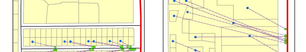
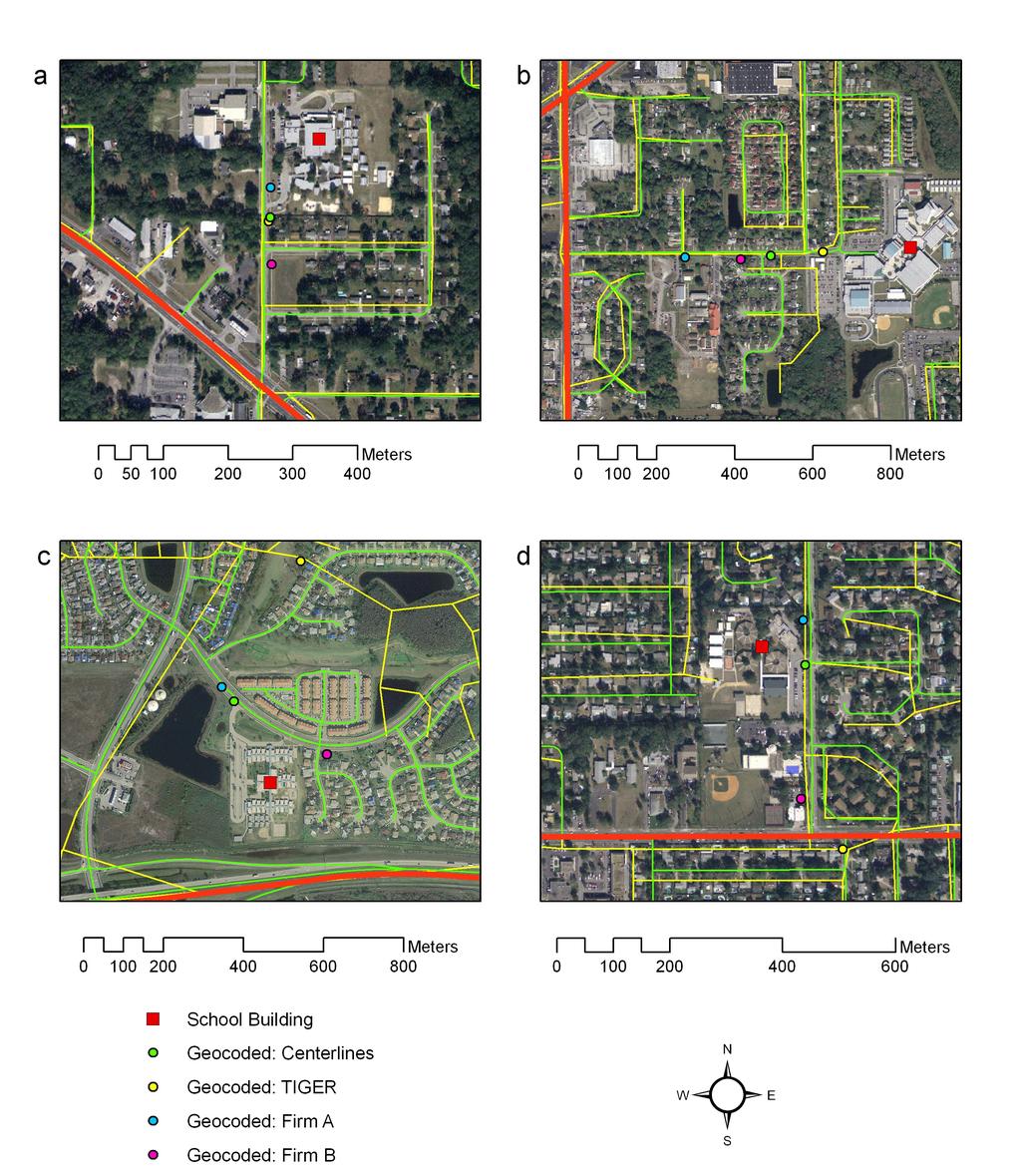
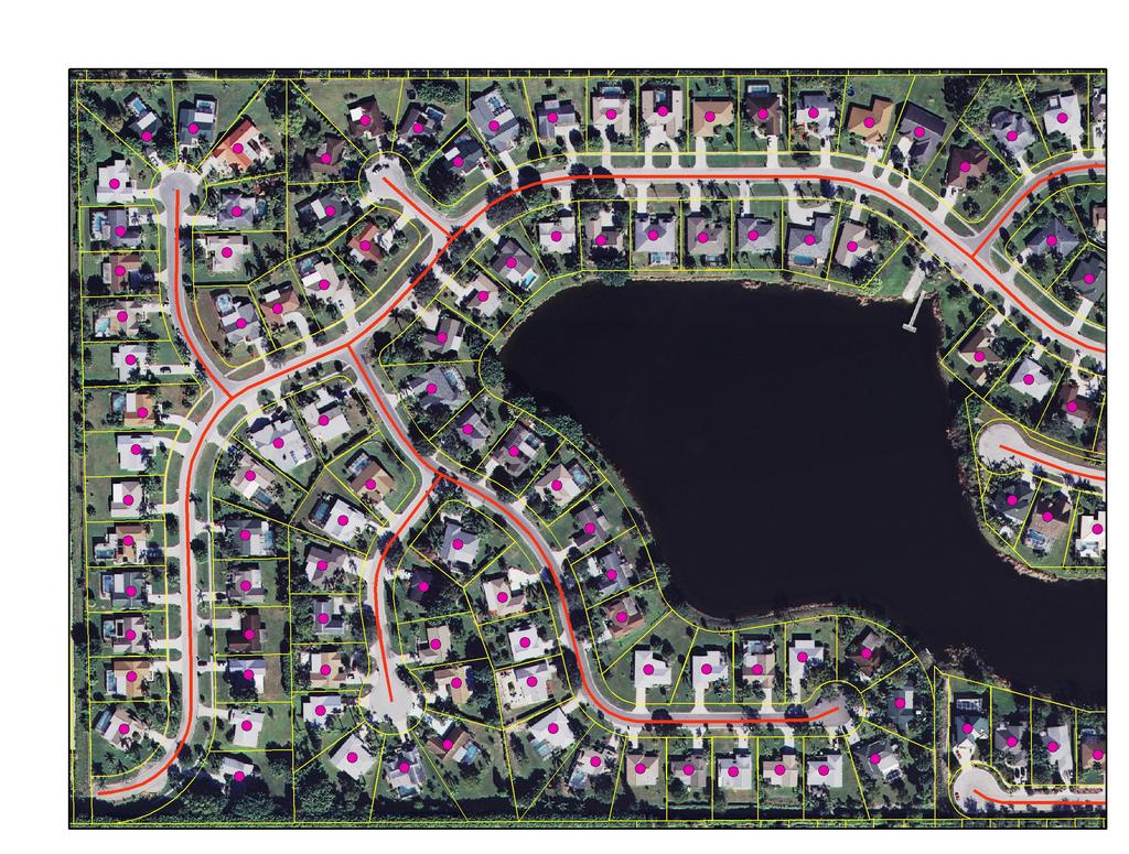
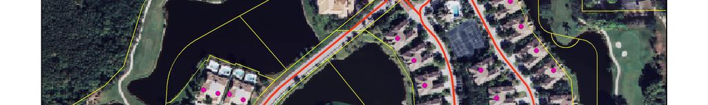
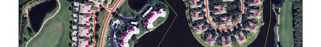
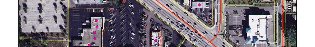
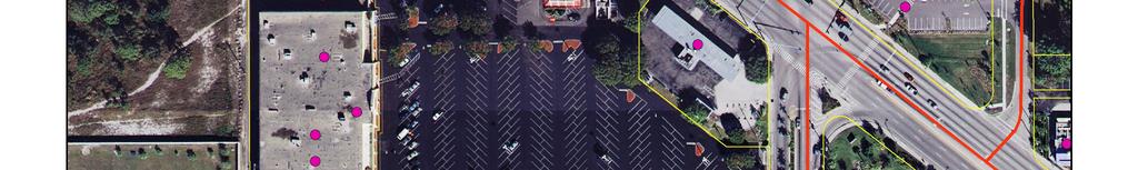
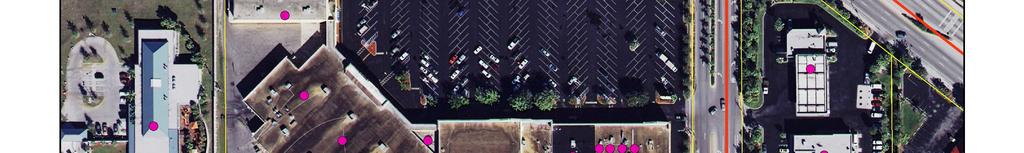
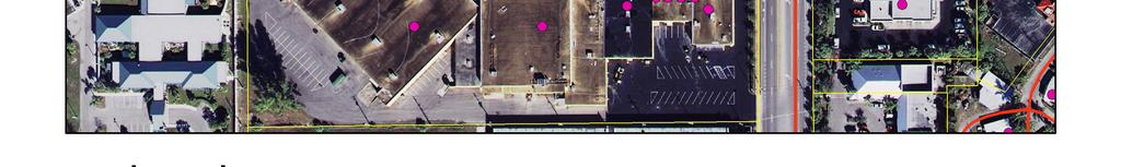
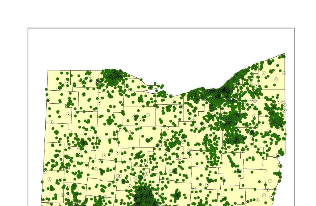
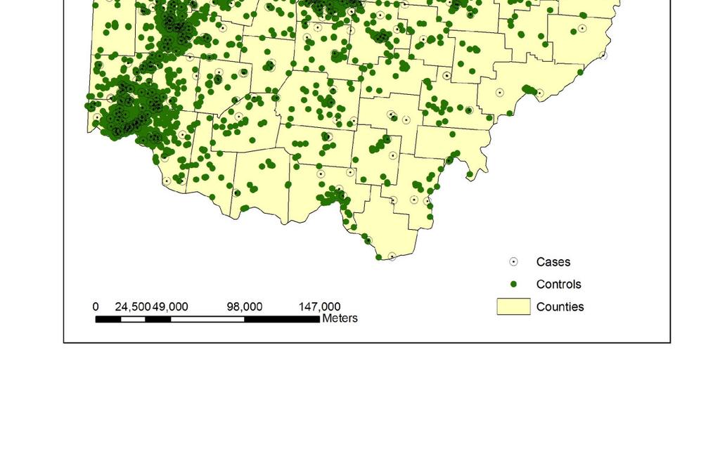
10 Research Case Studies Data sets School children and schools in Orlando County Sex offenders in Florida Banks and grocery stores in Florida Fishing and boat license holders in Florida Analyses Positional accuracy Repeatability Effects of positional error on spatial analysis Comparison of alternatives
11 Maple Street NE
12
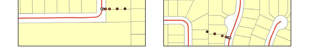
13 Left range: Right range:
14
15
16 441 Maple St NE

17 GoogleMaps: 441 Maple St NE

18 MapQuest: 441 Maple St NE
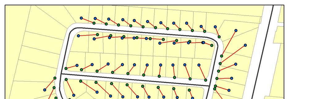
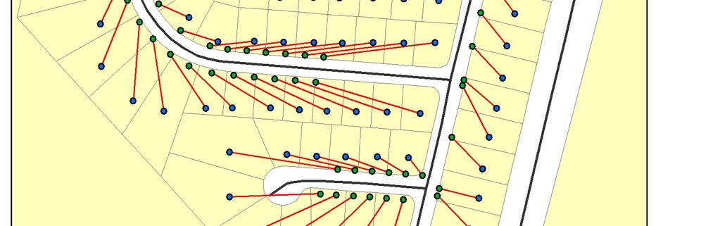
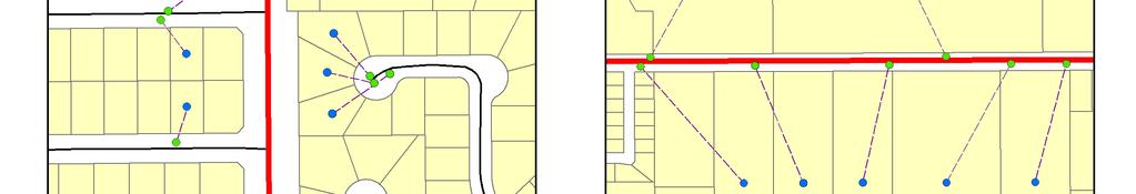
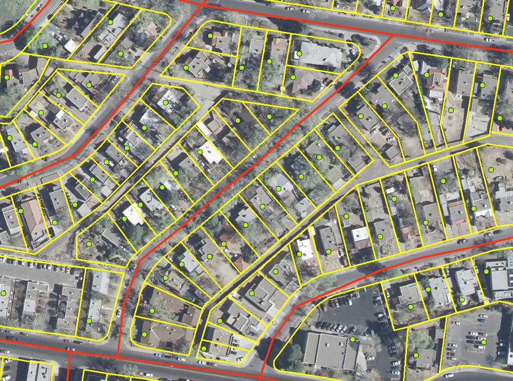
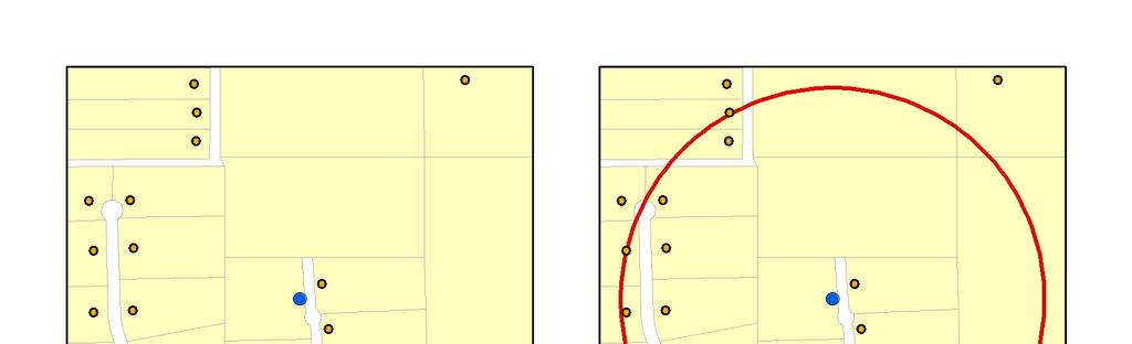
19 Error Measurement Tool Fishbone Tool

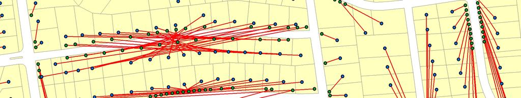
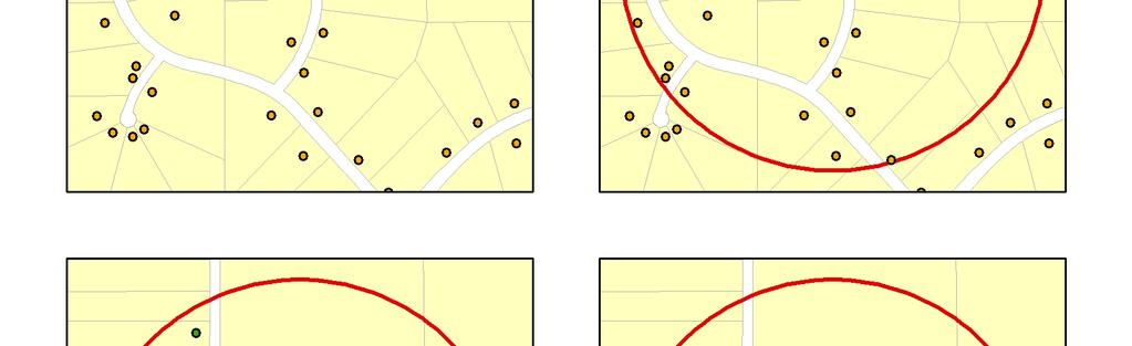
20 Results get messy sometimes

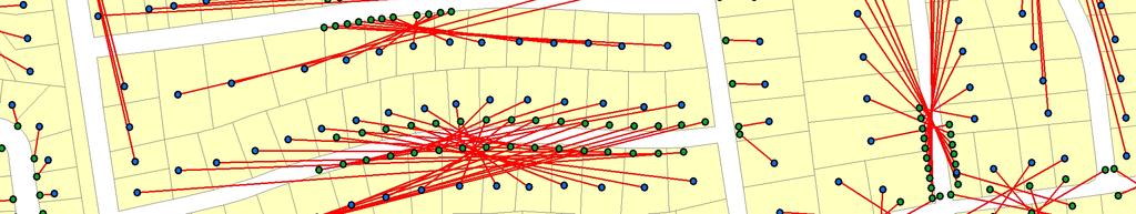
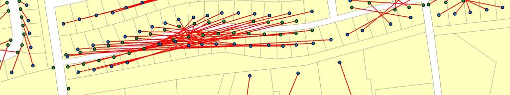
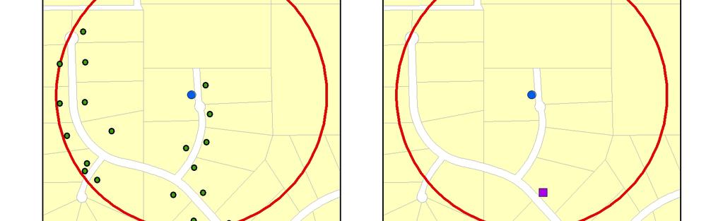
21 The Squeeze Effect
22 Typical Error Distribution Cumulative Frequency (%) N =104,865 school children in Orange County, FL ,000 Positional Error (m) Zandbergen, P.A Influence of geocoding quality on environmental exposure assessment of children living near high traffic roads. BMC Public Health, 7:37.
23 Typical Error Estimates Statistic Value (m) Log-normalized Q-Q plot Min ~0 4 Max 32,356 Mean 66 2 SD Median 90 th % 95 th % Expected Normal th % N , Observed Value Based on the 90 th percentile, typical street geocoding does not meet the accuracy standards for a 1:100,000 scale map based on National Map Accuracy Standards! Zandbergen, P.A Influence of geocoding quality on environmental exposure assessment of children living near high traffic roads. BMC Public Health, 7:37.


24 Quality of Street Reference Data


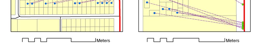
25 Use of Offsets Small offsets are commonly used Very minor effect on positional accuracy Optimum ~25 meters
26 Effect of Density and Parcel Size Cumulative Number of Locations (%) Urban Residential - Parcel < 1 acre Urban Residential - Parcel > 1 acre Rural Residential - Parcel < 1 acre Rural Residential - Parcel > 1 acre Positional Error (feet) Zandbergen, P.A. Spatial variability in the positional accuracy of street geocoding. International Journal of Geographical Information Science (under review).
27 Repeatability How do geocoding results (match rate and positional accuracy) vary by: Geocoding algorithms Street reference data Quality of street reference data is the most significant factor Local street centerlines and/or E-911data are typically superior How do commercial firms compare to results from GIS Analysts? Again, quality of street reference data dominates, which for most commercial firms is good (unless they use TIGER 2000 data) Substantial variability among providers No relationship between cost and quality


28 Volusia County, FL 4 land use types 3 street datasets Zandbergen, P.A. Repeatability of street geocoding. Computers and Geosciences (under review).
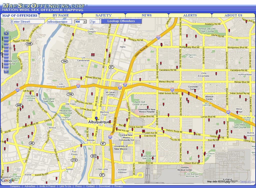
29 Example: Sex Offender Residency Restrictions Zandbergen, P.A. and T.C. Hart Reducing housing options for convicted sex offenders: Investigating the impact of residency restriction laws using GIS. Justice Research and Policy, 8:1-24.
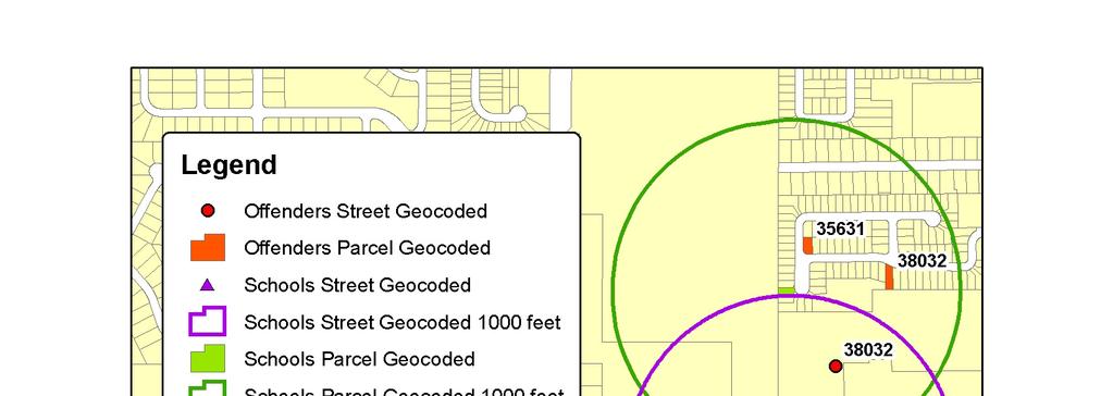
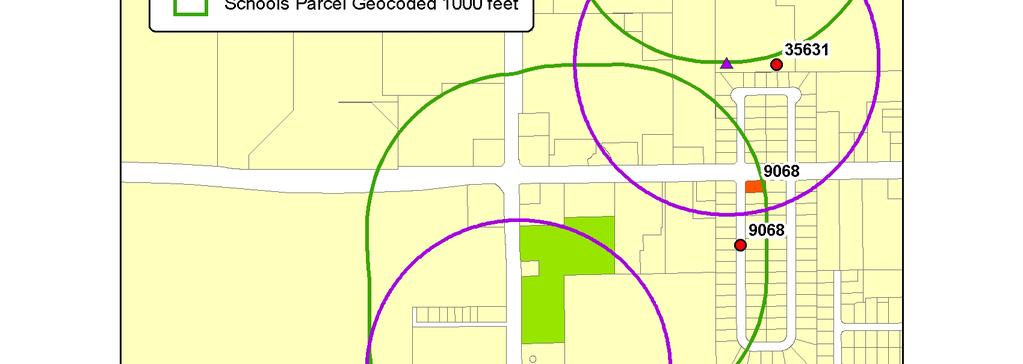
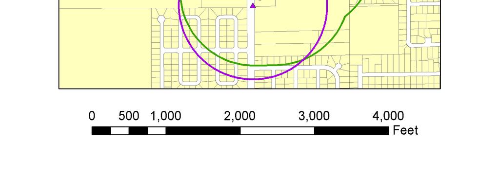
30
31 Errors in Classification Street geocoding of schools and offenders In Out Total Parcel geocoding of schools and offenders In Out Total False positives False negatives


32 Mapping Residency Restrictions: Parcel-level Zandbergen, P.A. and T.C. Hart Reducing housing options for convicted sex offenders: Investigating the impact of residency restriction laws using GIS. Justice Research and Policy, 8:1-24.
33 Example: Schools and School Children in Proximity to High Traffic Roads


34
35 Error and Bias in Analysis Results Zandbergen, P.A Influence of geocoding quality on environmental exposure assessment of children living near high traffic roads. BMC Public Health, 7:37.
36
37 Alternatives to Street Geocoding Street geocoding is dominant in the US Techniques used in other jurisdictions: Postal code (Canada) Address points (Australia and UK) Two alternatives for the US: Parcel boundaries Address points Both produce exceptional positional accuracy, but application currently limited by: Data availability / consistency Unproven match rates
38


39
40
41
42 Match rate results Match rates for different databases for Bay County, Fl Address Parcel Roads Commercial Banks Daycares Elevators Fishing Licenses Grocery Stores Sex Offenders Zandbergen, P.A. A comparison of address point, parcel and street geocoding techniques. Computers, Environment and Urban Systems (under review).
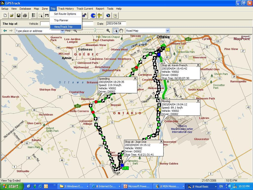
43 Error Propagation Modeling Not very well developed, for something as simple and common as street geocoding Monte-Carlo simulation of variability in: Match rate Positional accuracy Determine effects of error/bias on: Clustering Proximity analysis Neighborhood assignment Contribute to standards and procedures for geocoding In development.
44 Geospatial Privacy Collection of individual level data is growing rapidly in public and private sector Analysis of the individual level is very attractive for researches (overcomes MAUP and ecological fallacy issues) Spatial identifiers have not received the same level of concern as individual identifiers (like name) As geocoding becomes easier, cheaper and more accurate, so does the ability to reverse geocode spatial data Geospatial privacy has been recognized in the literature, but limited formal requirements or guidelines exist that recognize the increasing availability and capabilities of geospatial tools

45 Reverse Geocoding
46 Geographic Masking Traditional approach to protect privacy is through geographic masking typically a random perturbation Masking may alter data in undesirable ways effects of masking on spatial analysis has not received a lot of attention How much masking is needed to adequately protect geospatial privacy is poorly understood
47
48 Tracking Technologies Old-fashioned radio telemetry Traditional GPS GPS enabled cellphones Hybrid GPS / Wi-Fi Widespread adoption of (real-time) tracking is eminent

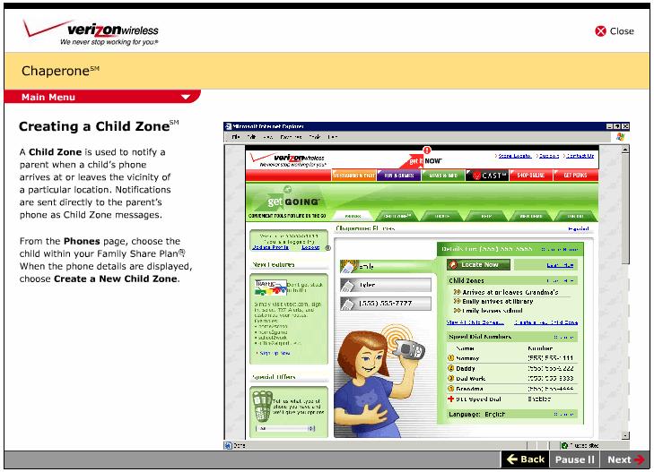
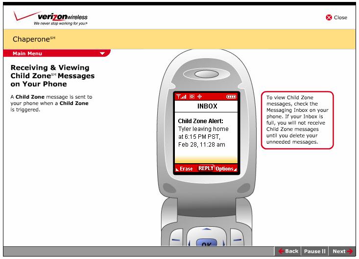
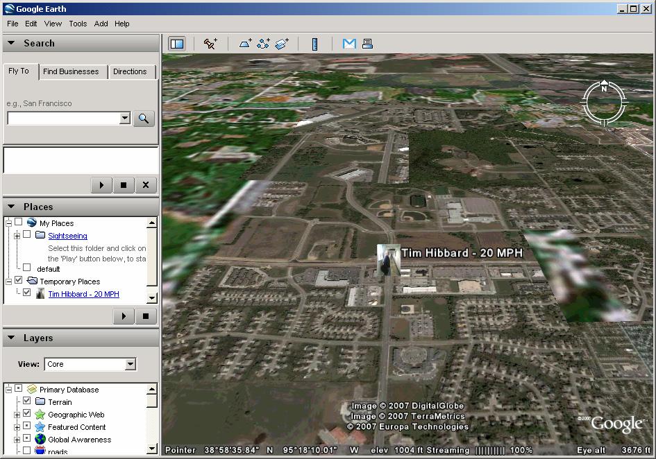
49 GPS-enabled Cellphones

50 Real-time Tracking
51

52 Google Earth Plug-ins

53
54
55

56 Real-time Online Tracking
57 Future Developments Address point geocoding will grow in importance and become the standard in the US Individual-level data will become a more widespread unit of analysis Tracking technologies will start to make a major impact Geospatial privacy protection needs to catch up to current trends
58 Elements of my research agenda Ongoing: Geocoding quality (completeness, positional accuracy, repeatability) Error propagation modeling Reverse geocoding and geographic masking Reliability of tracking technologies (i.e. cellphones vs. WiFi vs. GPS) and implications for geocoding Planned for: Spatial-temporal geocoding
59 Spatial-temporal Geocoding Where people spend their time not just where their mailing address is. Short-term: Where people live, work, shop etc. How people spend their day/week Long-term: Migration over years/decades How people spend their life Applications: transportation, emergency management, urban planning, environmental health How do we do this technically, practically and ethically?
Influence of street reference data on geocoding quality
 Geocarto International Vol. 26, No. 1, February 2011, 35 47 Influence of street reference data on geocoding quality Paul A. Zandbergen* Department of Geography, University of New Mexico, Bandelier West
Lecture 8 Geocoding. Dr. Zhang Spring, 2017
 Lecture 8 Geocoding Dr. Zhang Spring, 2017 Model of the course Using and making maps Navigating GIS maps Map design Working with spatial data Geoprocessing Spatial data infrastructure Digitizing File geodatabases
Reverse geocoding and implica1ons for geospa1al privacy. Paul Zandbergen Department of Geography University of New Mexico
 Reverse geocoding and implica1ons for geospa1al privacy Paul Zandbergen Department of Geography University of New Mexico Outline Geospatial privacy Geocoding / reverse geocoding Experimental design Results
Improving the Quality of Geocoded Data
 Improving the Quality of Geocoded Data NCCCP & NPCR Conference April 15, 2009 Kevin C. Ward, PhD, CTR Georgia Center for Cancer Statistics Census Geography Geographic Unit State County Census Tract (average
Central Cancer Registry Geocoding Needs
 Central Cancer Registry Geocoding Needs John P. Wilson, Daniel W. Goldberg, and Jennifer N. Swift Technical Report No. 13 Central Cancer Registry Geocoding Needs 1 Table of Contents Executive Summary...3
Chapter 10. What is geocoding?
 Chapter 10 Geocoding 10-1 Copyright McGraw-Hill Education. Permission required for reproduction or display. What is geocoding? The process of assigning a location, usually in the form of coordinate values
Accuracy and Precision of the NAACCR Geocoder. Recinda L Sherman, MPH CTR David J Lee, PhD University of Miami, Florida Cancer Data System
 Accuracy and Precision of the NAACCR Geocoder Recinda L Sherman, MPH CTR David J Lee, PhD University of Miami, Florida Cancer Data System Presentation Overview Overview FCDS Overview Geocoding quality
A COMPARISON OF GEOCODING BASELAYERS FOR ELECTRONIC MEDICAL RECORD DATA ANALYSIS
 A COMPARISON OF GEOCODING BASELAYERS FOR ELECTRONIC MEDICAL RECORD DATA ANALYSIS Christopher Ray Severns Submitted to the faculty of the University Graduate School In partial fulfillment of the requirements
geocoding crime data in Southern California cities for the project, Crime in Metropolitan
 Technical Document: Procedures for cleaning, geocoding, and aggregating crime incident data John R. Hipp, Charis E. Kubrin, James Wo, Young-an Kim, Christopher Contreras, Nicholas Branic, Michelle Mioduszewski,
GIS Lecture 8: Geocoding
 GIS Lecture 8: Geocoding 100 Elm Street 198 101 199 GIS 1 Outline Geocoding Overview Linear (Street) Geocoding Problems and Solutions Polygon Geocoding Geocoding in ArcGIS GIS 2 Geocoding Overview GIS
CRA Wiz & Fair Lending Wiz Geocoding Basics. August 2017
 CRA Wiz & Fair Lending Wiz Geocoding Basics August 2017 CRA Wiz & Fair Lending Wiz Recommended Geocoding Settings & Fall Back Options Geocoding Match Types Parcel Matches Street Matches Tract Matches ZIP
Geocoding DoubleCheck: A Unique Location Accuracy Assessment Tool for Parcel-level Geocoding
 Measuring, Modelling and Mapping our Dynamic Home Planet Geocoding DoubleCheck: A Unique Location Accuracy Assessment Tool for Parcel-level Geocoding Page 1 Geocoding is a process of converting an address
Copyright The McGraw-Hill Companies, Inc. Permission required for reproduction or display.
 Chapter 16. GEOCODING AND DYNAMIC SEGMENTATION 16.1 Geocoding 16.1.1 Geocoding Reference Database 16.1.2 The Address Matching Process 16.1.3 Address Matching Options Box 16.1 Scoring System for Geocoding
Geocoding Techniques and Options for US and International Locations
 Federal GIS Conference 2014 February 10 11, 2014 Washington DC Geocoding Techniques and Options for US and International Locations Tosia Shall, Esri Doug Geverdt, Census Chuck Whittington, Census Types
Geocoding Address Data & Using Geocoded Data
 Geocoding Address Data & Using Geocoded Data This document located at /geocoding.pdf Using this Document & Terms of Use Copyright 2014. ProximityOne. All Rights Reserved. Geocoding Address Data Terms of
Designing Service Coverage and Measuring Accessibility and Serviceability
 Designing Service Coverage and Measuring Accessibility and Serviceability INFORMS Annual Meeting San Francisco, CA November 9-12, 2014 EunSu Lee, Ph.D., GISP, CPIM, CSCP Agenda Introduction Objectives
GIS Data Sources. Thomas Talbot
 GIS Data Sources Thomas Talbot Chief, Environmental Health Surveillance Section Bureau of Environmental & Occupational Epidemiology New York State Department of Health Outline Sources of Data Census, health,
A method and a tool for geocoding and record linkage
 WORKING PAPERS A method and a tool for geocoding and record linkage Omar CHARIF 1 Hichem OMRANI 1 Olivier KLEIN 1 Marc SCHNEIDER 1 Philippe TRIGANO 2 CEPS/INSTEAD, Luxembourg 1 Heudiasyc Laboratory, Technology
2020 CENSUS LOCAL UPDATE OF CENSUS ADDRESSES OPERATION (LUCA) U.S. Census Bureau Geography Division
 U.S. Census Bureau Geography Division") 2020 CENSUS LOCAL UPDATE OF CENSUS ADDRESSES OPERATION (LUCA) U.S. Census Bureau Geography Division 1 Agenda 2020 Census Local Update of Census Addresses Operation (LUCA) Participation in LUCA Why participate
2020 CENSUS LOCAL UPDATE OF CENSUS ADDRESSES OPERATION (LUCA) U.S. Census Bureau Geography Division 1 Agenda 2020 Census Local Update of Census Addresses Operation (LUCA) Participation in LUCA Why participate
Lessons from a Pilot Study for a National Probability Sample Survey of Chinese Adults Focusing on Internal Migration
 Lessons from a Pilot Study for a National Probability Sample Survey of Chinese Adults Focusing on Internal Migration Donald J. Treiman, Yao Lu, Yi Pan, Yaqiang Qi, Shige Song, and William Mason (all California
A Probabilistic Geocoding System based on a National Address File
 A Probabilistic Geocoding System based on a National Address File Peter Christen, Tim Churches and Alan Willmore Data Mining Group, Australian National University Centre for Epidemiology and Research,
Experiences with the Use of Addressed Based Sampling in In-Person National Household Surveys
 Experiences with the Use of Addressed Based Sampling in In-Person National Household Surveys Jennifer Kali, Richard Sigman, Weijia Ren, Michael Jones Westat, 1600 Research Blvd, Rockville, MD 20850 Abstract
Postal Codes OM by Federal Ridings File (PCFRF) 2013 Representation Order, Reference Guide
 2013 Representation Order, Reference Guide") Catalogue no. 92-178-G ISSN 2369-9809 Postal Codes OM by Federal Ridings File (PCFRF) 2013 Representation Order, Reference Guide June 2017 Release date: December 13, 2017 How to obtain more information
Catalogue no. 92-178-G ISSN 2369-9809 Postal Codes OM by Federal Ridings File (PCFRF) 2013 Representation Order, Reference Guide June 2017 Release date: December 13, 2017 How to obtain more information
MAPS & ENHANCED CONTENT
 MAPS & ENHANCED Delivering high quality maps to enterprise, government, automotive and consumer markets MAPS & SUPERIOR HOW SEAMLESS COVERAGE IS COMMUNITY DRIVEN THE FRESHEST MAP The heart of location
Geocoding: Acquiring Location Intelligence to Make Be er Business Decisions
 A M e l i s s a D a t a W h i t e Pa p e r Geocoding: Acquiring Location Intelligence to Make Be er Business Decisions 2 Introduction Geocoding: Acquiring Location Intelligence to Make Better Business
On the suitability of Volunteered Geographic Information for the purpose of geocoding
 On the suitability of Volunteered Geographic Information for the purpose of geocoding Christof AMELUNXEN Abstract The automated process of assigning geographic coordinates to textual descriptions of a
Lecture 8: GIS Data Error & GPS Technology
 Lecture 8: GIS Data Error & GPS Technology A. Introduction We have spent the beginning of this class discussing some basic information regarding GIS technology. Now that you have a grasp of the basic terminology
Geocoding and Address Matching
 LAB PREP: Geocoding and Address Matching Environmental, Earth, & Ocean Science 381 -Spring 2015 - Geocoding The process by which spatial locations are determined using coordinate locations specified in
Statewide State Roads Layer Michigan Geographic Framework Field Definitions
 Statewide State Roads Layer Michigan Geographic Framework Field Definitions (Shapefile Attribute Table) (June 1, 2014 Version 14a) The following field definitions make up the shapefile attribute table
EXPERT GROUP MEETING ON CONTEMPORARY PRACTICES IN CENSUS MAPPING AND USE OF GEOGRAPHICAL INFORMATION SYSTEMS New York, 29 May - 1 June 2007
 EXPERT GROUP MEETING ON CONTEMPORARY PRACTICES IN CENSUS MAPPING AND USE OF GEOGRAPHICAL INFORMATION SYSTEMS New York, 29 May - 1 June 2007 STATEMENT OF DR. PAUL CHEUNG DIRECTOR OF THE UNITED NATIONS STATISTICS
An ESRI White Paper May 2009 ArcGIS 9.3 Geocoding Technology
 An ESRI White Paper May 2009 ArcGIS 9.3 Geocoding Technology ESRI 380 New York St., Redlands, CA 92373-8100 USA TEL 909-793-2853 FAX 909-793-5953 E-MAIL info@esri.com WEB www.esri.com Copyright 2009 ESRI
Propagation Modelling White Paper
 Propagation Modelling White Paper Propagation Modelling White Paper Abstract: One of the key determinants of a radio link s received signal strength, whether wanted or interfering, is how the radio waves
VGIN Geocoding Service
 VGIN Geocoding Service What is Geocoding? Geocoding is the process of assigning geographic coordinates (e.g., latitude and longitude) to data records such as street addresses. With geographic coordinates,
Analysis and Geoprocessing Sessions and Demo Theater Presentations
 Esri User Conference 2018 Analysis and Geoprocessing Sessions and Demo Theater Presentations TUESDAY 7/10 -------------------------------------------------------------------------------------------------------------------------------------------
In-Office Address Canvassing for the 2020 Census: an Overview of Operations and Initial Findings
 In-Office Address Canvassing for the 2020 Census: an Overview of Operations and Initial Findings Michael Commons Address and Spatial Analysis Branch Geography Division U.S. Census Bureau In-Office Address
The ONS Longitudinal Study
 Geography and Geographical Analysis using the ONS Longitudinal Study Christopher Marshall & Julian Buxton CeLSIUS Aims of the Presentation What is the ONS LS and what data does it contain? What geographical
National Longitudinal Study of Adolescent Health. Public Use Contextual Database. Waves I and II. John O.G. Billy Audra T. Wenzlow William R.
 National Longitudinal Study of Adolescent Health Public Use Contextual Database Waves I and II John O.G. Billy Audra T. Wenzlow William R. Grady Carolina Population Center University of North Carolina
ADJACENT BAND COMPATIBILITY OF TETRA AND TETRAPOL IN THE MHZ FREQUENCY RANGE, AN ANALYSIS COMPLETED USING A MONTE CARLO BASED SIMULATION TOOL
 European Radiocommunications Committee (ERC) within the European Conference of Postal and Telecommunications Administrations (CEPT) ADJACENT BAND COMPATIBILITY OF TETRA AND TETRAPOL IN THE 380-400 MHZ
Overview of Census Bureau Geographic Areas and Concepts
 Overview of Census Bureau Geographic Areas and Concepts Drew Stanislaw US Census Bureau WVAGP Annual Meeting Shepherdstown, WV June 13, 2011 1 What is the role of geography in the Census? The Census count
Economic and Social Council
 United Nations Economic and Social Council Distr.: General 21 May 2012 Original: English E/CONF.101/57 Tenth United Nations Conference on the Standardization of Geographical Names New York, 31 July 9 August
Using Location-Based Services to Improve Census and Demographic Statistical Data. Deirdre Dalpiaz Bishop May 17, 2012
 Using Location-Based Services to Improve Census and Demographic Statistical Data Deirdre Dalpiaz Bishop May 17, 2012 U.S. Census Bureau Mission To serve as the leading source of quality data about the
ARCGIS DESKTOP DEMO (GEOCODING, SERVICE AREAS, TABULAR & SPATIAL JOINS)
") ARCGIS DESKTOP DEMO (GEOCODING, SERVICE AREAS, TABULAR & SPATIAL JOINS) Indiana State GIS Day Conference: September 22, 2015 ASHLEY SUITER GIS Data Analyst Epidemiology Resource Center Indiana State Department
ARCGIS DESKTOP DEMO (GEOCODING, SERVICE AREAS, TABULAR & SPATIAL JOINS) Indiana State GIS Day Conference: September 22, 2015 ASHLEY SUITER GIS Data Analyst Epidemiology Resource Center Indiana State Department
QualityStage AVI+Geo+US Census+UK PAF v10.5 Output as of 2015 Q3 AVI Release
 Field Name Organization Department Function Building Subbuilding HouseNumber Street DependentStreet POBox Dependent DoubleDependent PostCode PostCodePrimary PostCodeSecondary Super Sub Country ISO3166_2
ArcGIS Tutorial: Geocoding Addresses
 U ArcGIS Tutorial: Geocoding Addresses Introduction Address data can be applied to a variety of research questions using GIS. Once imported into a GIS, you can spatially display the address locations and
Geographic Terms. Manifold Data Mining Inc. January 2016
 Geographic Terms Manifold Data Mining Inc. January 2016 The following geographic terms are adapted from the standard definition of Census geography from Statistics Canada. Block-face A block-face is one
National Census Geography Some lessons learned and future challenges in European countries
 UNSD-AITRS Regional Workshop on the Integration of Statistical and Geospatial Information Amman, Jordan, 16-20 February, 2015 National Census Geography Some lessons learned and future challenges in European
Postal Code Conversion for Data Analysis
 Postal Code Conversion for Data Analysis An overview of the PCCF and PCCF+ Saeeda Khan Michael Tjepkema Health Analysis Division, Statistics Canada December 1, 2015 www.statcan.gc.ca Outline 1. Postal
Transforming the Census
 Transforming the Census David Martin (NCRM, UK Data Service) NCRM Autumn School, 2017 Transforming the Census Censuses are changing! Why does it matter? International context ONS Census Transformation
Project summary. Key findings, Winter: Key findings, Spring:
 Summary report: Assessing Rusty Blackbird habitat suitability on wintering grounds and during spring migration using a large citizen-science dataset Brian S. Evans Smithsonian Migratory Bird Center October
Saint Lucia Country Presentation
 Saint Lucia Country Presentation Workshop on Integrating Population and Housing with Agricultural Censuses 10 th 12 th June, 2013 Edwin St Catherine Director of Statistics Household and Population Census
Eastlan Ratings Radio Audience Estimate Survey Methodology
 Survey Area Eastlan Ratings Radio Audience Estimate Survey Methodology Eastlan Resources, LLC has defined each radio market surveyed into an Eastlan Survey Area (ESA). Generally, an Eastlan Survey Area
THE TOP 100 CITIES PRIMED FOR SMART CITY INNOVATION
 THE TOP 100 CITIES PRIMED FOR SMART CITY INNOVATION Identifying U.S. Urban Mobility Leaders for Innovation Opportunities 6 March 2017 Prepared by The Top 100 Cities Primed for Smart City Innovation 1.
The Road to 2020 Census
 The Road to 2020 Census Wednesday, May 17 th, 2017 9:00 am-12n North Central Texas Council of Governments 616 Six Flags Drive, Arlington, TX Arlington, TX 1 AGENDA OVERVIEW Decennial Census Basics, 2010
Version 2.2 April Census Local Update of Census Addresses Operation (LUCA) Frequently Asked Questions
 Frequently Asked Questions") Version 2.2 April 2017 2020 Census Local Update of Census Addresses Operation (LUCA) Frequently Asked Questions [This page intentionally left blank] 2020 Census LUCA Frequently Asked Questions TABLE OF
Version 2.2 April 2017 2020 Census Local Update of Census Addresses Operation (LUCA) Frequently Asked Questions [This page intentionally left blank] 2020 Census LUCA Frequently Asked Questions TABLE OF
2012 AMERICAN COMMUNITY SURVEY RESEARCH AND EVALUATION REPORT MEMORANDUM SERIES #ACS12-RER-03
 February 3, 2012 2012 AMERICAN COMMUNITY SURVEY RESEARCH AND EVALUATION REPORT MEMORANDUM SERIES #ACS12-RER-03 DSSD 2012 American Community Survey Research Memorandum Series ACS12-R-01 MEMORANDUM FOR From:
Pitney Bowes Software Geocoding: Capabilities and Roadmap
 Pitney Bowes Software Geocoding: Capabilities and Roadmap Berk Charlton Global Director of Geocoding Product Management Kevin Cartin Managing Director of Geocoding Engineering 1 Overview Looking Back A
2010 Census Mapping Evolution, Potentialities and Integration to the National Spatial Data Infrastructure
 2010 Census Mapping Evolution, Potentialities and Integration to the National Spatial Data Infrastructure Miriam Barbuda, MsC LATIN AMERICA GEOSPATIAL FORUM Brazil, Rio de Janeiro, 15-17August 2012 BRAZIL
RAPTORXR. Broadband TV White Space (TVWS) Backhaul Digital Radio System
 Backhaul Digital Radio System") RAPTORXR Broadband TV White Space (TVWS) Backhaul Digital Radio System TECHNICAL OVERVIEW AND DEPLOYMENT GUIDE CONTACT: BBROWN@METRICSYSTEMS.COM Broadband White Space Mesh Infrastructure LONG REACH - FAST
RAPTORXR Broadband TV White Space (TVWS) Backhaul Digital Radio System TECHNICAL OVERVIEW AND DEPLOYMENT GUIDE CONTACT: BBROWN@METRICSYSTEMS.COM Broadband White Space Mesh Infrastructure LONG REACH - FAST
Analysis Techniques for WiMAX Network Design Simulations
 Technical White Paper Analysis Techniques for WiMAX Network Design Simulations The Power of Smart Planning 1 Analysis Techniques for WiMAX Network Jerome Berryhill, Ph.D. EDX Wireless, LLC Eugene, Oregon
Traffic Management for Smart Cities TNK115 SMART CITIES
 Traffic Management for Smart Cities TNK115 SMART CITIES DAVID GUNDLEGÅRD DIVISION OF COMMUNICATION AND TRANSPORT SYSTEMS Outline Introduction Traffic sensors Traffic models Frameworks Information VS Control
2020 Census Local Update of Census Addresses. Operation (LUCA) Promotion
 Promotion") 2020 Census Local Update of Census Addresses Atlanta Regional Office Managing Census Operations in: AL, FL, GA, LA, MS, NC, SC Operation (LUCA) Promotion 2020 Census Overview What is LUCA? Agenda LUCA
2020 Census Local Update of Census Addresses Atlanta Regional Office Managing Census Operations in: AL, FL, GA, LA, MS, NC, SC Operation (LUCA) Promotion 2020 Census Overview What is LUCA? Agenda LUCA
The 2020 Census Geographic Partnership Opportunities
 The 2020 Census Geographic Partnership Opportunities Web Adams Geographer, U.S. Census Bureau New York Regional Office 1 Geographic Partnership Opportunities The 2020 Census Local Update of Census Addresses
US Census. Thomas Talbot February 5, 2013
 US Census Thomas Talbot February 5, 2013 Outline Census Geography TIGER Files Decennial Census - Complete count American Community Survey Yearly Sample Obtaining Data - American Fact Finder - Census FTP
On-site Traffic Accident Detection with Both Social Media and Traffic Data
 On-site Traffic Accident Detection with Both Social Media and Traffic Data Zhenhua Zhang Civil, Structural and Environmental Engineering University at Buffalo, The State University of New York, Buffalo,
The American Community Survey. An Esri White Paper August 2017
 An Esri White Paper August 2017 Copyright 2017 Esri All rights reserved. Printed in the United States of America. The information contained in this document is the exclusive property of Esri. This work
FREMONT COUNTY. APPLICATION FOR ZONE CHANGE #2 USE DESIGNATION PLAN (Requires Subsequent Approval of ZC #2 Final Designation Plan) 1.
 1.") FREMONT COUNTY APPLICATION FOR ZONE CHANGE #2 USE DESIGNATION PLAN (Requires Subsequent Approval of ZC #2 Final Designation Plan) 1. Project Name: 2. Applicant: Address: City: State: Zip Code: Telephone
FREMONT COUNTY APPLICATION FOR ZONE CHANGE #2 USE DESIGNATION PLAN (Requires Subsequent Approval of ZC #2 Final Designation Plan) 1. Project Name: 2. Applicant: Address: City: State: Zip Code: Telephone
The 2020 Census Geographic Partnership Opportunities
 The 2020 Census Geographic Partnership Opportunities Brian Timko Branch Chief Address Data Collection and Products Branch Geography Division U.S. Census Bureau 1 Geographic Partnership Opportunities The
Regional management of underwater noise made possible: an achievement of the BIAS project
 Regional management of underwater noise made possible: an achievement of the BIAS project T. Folegot, D. Clorennec, Quiet-Oceans, Brest A. Nikolopoulos, F. Fyhr, Aquabiota Water Research, Stockholm M.
CHAPTER 3. Public Schools Facility Element
 CHAPTER 3 Public Schools Facility Element Page 1 of 12 CHAPTER 3 PUBLIC SCHOOL FACILITIES ELEMENT GOAL 3.1: Collaborate and coordinate with the School Board of Volusia County to provide and maintain a
How Many Imputations are Really Needed? Some Practical Clarifications of Multiple Imputation Theory
 Prev Sci (2007) 8:206 213 DOI 10.1007/s11121-007-0070-9 How Many Imputations are Really Needed? Some Practical Clarifications of Multiple Imputation Theory John W. Graham & Allison E. Olchowski & Tamika
Comparison of Simulation-Based Dynamic Traffic Assignment Approaches for Planning and Operations Management
 Comparison of Simulation-Based Dynamic Traffic Assignment Approaches for Planning and Operations Management Ramachandran Balakrishna Daniel Morgan Qi Yang Howard Slavin Caliper Corporation 4 th TRB Conference
2020 Census Local Update of Census Addresses Operation (LUCA)
") 2020 Census Local Update of Census Addresses Operation (LUCA) The Decennial Census The purpose is to conduct a census of population and housing and disseminate results to the President, the States, and
2020 Census Local Update of Census Addresses Operation (LUCA) The Decennial Census The purpose is to conduct a census of population and housing and disseminate results to the President, the States, and
Prepared for: CACI Acorn microsite Prepared by: CACI Product Development Team Date issued: 15th March Acorn technical document
 Prepared for: CACI Acorn microsite Prepared by: CACI Product Development Team Date issued: 15th March 2013 Acorn technical document Table of Contents 1. Introduction... 3 1.1. What is Acorn?... 3 1.2.
3 Economic Development
 3 Economic Development Introduction: The Economic Development Element of the Comprehensive Plan is intended to guide the climate for enterprise and commercial exchange in Buckley and reinforce the overall
CHAPTER 11 PRELIMINARY SITE PLAN APPROVAL PROCESS
 CHAPTER 11 PRELIMINARY SITE PLAN APPROVAL PROCESS 11.01.00 Preliminary Site Plan Approval 11.01.01 Intent and Purpose 11.01.02 Review 11.01.03 Application 11.01.04 Development Site to be Unified 11.01.05
Geocoding regional and remote poor quality address records with confidence
 Geocoding regional and remote poor quality address records with confidence Miro Palfy Statistical Analyst, SA NT DataLink The Australian Government provides financial support to SA NT DataLink through
INTEGRATED COVERAGE MEASUREMENT SAMPLE DESIGN FOR CENSUS 2000 DRESS REHEARSAL
 INTEGRATED COVERAGE MEASUREMENT SAMPLE DESIGN FOR CENSUS 2000 DRESS REHEARSAL David McGrath, Robert Sands, U.S. Bureau of the Census David McGrath, Room 2121, Bldg 2, Bureau of the Census, Washington,
Harnessing Census Microdata
 Harnessing Census Microdata Dr Barry Leventhal, BarryAnalytics Limited MRS CGG Seminar 5 th November 2014 Agenda Introduction to Census Microdata Microdata products from the UK Census Case study applications
Daniel R. Cahoy Smeal College of Business Penn State University VALGEN Workshop January 20-21, 2011
 Effective Patent : Making Sense of the Information Overload Daniel R. Cahoy Smeal College of Business Penn State University VALGEN Workshop January 20-21, 2011 Patent vs. Statistical Analysis Statistical
SMART PLACES WHAT. WHY. HOW.
 SMART PLACES WHAT. WHY. HOW. @adambeckurban @smartcitiesanz We envision a world where digital technology, data, and intelligent design have been harnessed to create smart, sustainable cities with highquality
Event History Calendar (EHC) Between-Wave Moves File. Codebook
 Between-Wave Moves File. Codebook") 2325 Event History Calendar (EHC) BetweenWave Moves File Codebook Number of Variables 23 Thursday July 2 28 4:5 PM 2325 Event History Calendar (EHC) BetweenWave Moves File EHCV "RELEASE NUMBER" NUM(.)
2325 Event History Calendar (EHC) BetweenWave Moves File Codebook Number of Variables 23 Thursday July 2 28 4:5 PM 2325 Event History Calendar (EHC) BetweenWave Moves File EHCV "RELEASE NUMBER" NUM(.)
LOCATION PRIVACY & TRAJECTORY PRIVACY. Elham Naghizade COMP20008 Elements of Data Processing 20 rd May 2016
 LOCATION PRIVACY & TRAJECTORY PRIVACY Elham Naghizade COMP20008 Elements of Data Processing 20 rd May 2016 Part I TRAJECTORY DATA: BENEFITS & CONCERNS Ubiquity of Trajectory Data Location data being collected
Coastside Fire Protection District
 Folsom (Sacramento), CA Management Consultants Fire Station Relocation Study for the Coastside Fire Protection District Volume 1 of 2 Main Report February 19, 2014 www.ci.pasadena.ca.us 2250 East Bidwell
Participant Statistical Areas Program for the 2010 Census. Vince Osier COPAFS Quarterly Meeting Washington, DC December 8, 2006
 Participant Statistical Areas Program for the 2010 Census Vince Osier COPAFS Quarterly Meeting Washington, DC December 8, 2006 1 Participant Statistical Areas Census Tracts Block Groups Census County Divisions
NCRIS Capability 5.7: Population Health and Clinical Data Linkage
 NCRIS Capability 5.7: Population Health and Clinical Data Linkage National Collaborative Research Infrastructure Strategy Issues Paper July 2007 Issues Paper Version 1: Population Health and Clinical Data
GPS Accuracy in Urban Environments Using Post-Processed CORS Data
 GPS Accuracy in Urban Environments Using Post-Processed CORS Data Knute A. Berstis, Gerald L. Mader NOAA, NOS, National Geodetic Survey Silver Spring, MD Aaron Jensen US Census Bureau Washington, DC Presentation
2020 Census Local Update of Census Addresses. Operation (LUCA) Promotion
 Promotion") 2020 Census Local Update of Census Addresses Atlanta Regional Office Managing Census Operations in: AL, FL, GA, LA, MS, NC, SC Operation (LUCA) Promotion 2020 Census Overview What is LUCA? Agenda LUCA
2020 Census Local Update of Census Addresses Atlanta Regional Office Managing Census Operations in: AL, FL, GA, LA, MS, NC, SC Operation (LUCA) Promotion 2020 Census Overview What is LUCA? Agenda LUCA
2020 Population and Housing Census Planning Perspective and challenges for data collection
 2020 Population and Housing Census Planning Perspective and challenges for data collection Mexico Contents Background of Censuses in Mexico Planning the 2020 Census Georeferencing Statistical Information
Green/Blue Metrics Meeting June 20, 2017 Summary
 Short round table introductions of participants Paul Villenueve, Carleton, Co-lead Green/Blue, Matilda van den Bosch, UBC, Co-lead Green/Blue Dan Crouse, UNB Lorien Nesbitt, UBC Audrey Smargiassi, Uof
Economic and Social Council
 United Nations Economic and Social Council Distr.: General 21 March 2012 ECE/CES/2012/22 Original: English Economic Commission for Europe Conference of European Statisticians Sixtieth plenary session Paris,
Clustering of traffic accidents with the use of the KDE+ method
 Richard Andrášik*, Michal Bíl Transport Research Centre, Líšeňská 33a, 636 00 Brno, Czech Republic *e-mail: andrasik.richard@gmail.com Clustering of traffic accidents with the use of the KDE+ method TABLE
Huawei response to the Ofcom call for input: Fixed Wireless Spectrum Strategy
 Huawei response to the Fixed Wireless Spectrum Strategy Summary Huawei welcomes the opportunity to comment on this important consultation on use of Fixed wireless access. We consider that lower traditional
ONLINE APPENDIX: SUPPLEMENTARY ANALYSES AND ADDITIONAL ESTIMATES FOR. by Martha J. Bailey, Olga Malkova, and Zoë M. McLaren.
 ONLINE APPENDIX: SUPPLEMENTARY ANALYSES AND ADDITIONAL ESTIMATES FOR DOES ACCESS TO FAMILY PLANNING INCREASE CHILDREN S OPPORTUNITIES? EVIDENCE FROM THE WAR ON POVERTY AND THE EARLY YEARS OF TITLE X by
ESP 171 Urban and Regional Planning. Demographic Report. Due Tuesday, 5/10 at noon
 ESP 171 Urban and Regional Planning Demographic Report Due Tuesday, 5/10 at noon Purpose The starting point for planning is an assessment of current conditions the answer to the question where are we now.
Adopted March 17, 2009 (Ordinance 09-15)
") ECONOMIC ELEMENT of the PINELLAS COUNTY COMPREHENSIVE PLAN Prepared By: The Pinellas County Planning Department as staff to the LOCAL PLANNING AGENCY for THE BOARD OF COUNTY COMMISSIONERS OF PINELLAS COUNTY,
ECONOMIC ELEMENT of the PINELLAS COUNTY COMPREHENSIVE PLAN Prepared By: The Pinellas County Planning Department as staff to the LOCAL PLANNING AGENCY for THE BOARD OF COUNTY COMMISSIONERS OF PINELLAS COUNTY,
DANE COUNTY ORDINANCE AMENDMENT NO: Internal Tracking Number: RECU25846
 DANE COUNTY ORDINANCE AMENDMENT NO: 10314 Internal Tracking Number: RECU25846 Amending Section 10.03 relating to Zoning Districts in the Town of Cottage Grove. The Dane County Board of Supervisors does
Confidently Assess Risk Using Public Records Data with Scalable Automated Linking Technology (SALT)
") WHITE PAPER Linking Liens and Civil Judgments Data Confidently Assess Risk Using Public Records Data with Scalable Automated Linking Technology (SALT) Table of Contents Executive Summary... 3 Collecting
WHITE PAPER Linking Liens and Civil Judgments Data Confidently Assess Risk Using Public Records Data with Scalable Automated Linking Technology (SALT) Table of Contents Executive Summary... 3 Collecting
AN OVERVIEW OF THE STATE OF MARINE SPATIAL PLANNING IN THE MEDITERRANEAN COUNTRIES MALTA REPORT
 AN OVERVIEW OF THE STATE OF MARINE SPATIAL PLANNING IN THE MEDITERRANEAN COUNTRIES MALTA REPORT Malta Environment & Planning Authority May 2007 AN OVERVIEW OF THE STATE OF MARINE SPATIAL PLANNING IN THE
Global Position Paper on Fishery Rights-Based Management
 Light tower Tatjana Gerling/WWF International Global Position Paper on Fishery Rights-Based Management WWF believes that appropriate, clear and enforceable fishing entitlements and responsibilities are
ECONOMIC ELEMENT. of the PINELLAS COUNTY COMPREHENSIVE PLAN. Prepared By: The Pinellas County Planning Department. as staff to the
 ECONOMIC ELEMENT of the PINELLAS COUNTY COMPREHENSIVE PLAN Prepared By: The Pinellas County Planning Department as staff to the LOCAL PLANNING AGENCY for THE BOARD OF COUNTY COMMISSIONERS OF PINELLAS COUNTY,