SPACE OBSERVATIONS FOR MARITIME DOMAIN AWARENESS
|
|
|
- Bertha Chandler
- 6 years ago
- Views:
Transcription
1 SPACE OBSERVATIONS FOR MARITIME DOMAIN AWARENESS Review and succes stories Tools : Positionning (GNSS) Identification ( VMS, S-AIS,..) Detection (SAR) Oil spill - IUU (INN) - Illegal transhipment Safety Security Dominique DAGORNE IRD/IMAGO Thanks to Commercials supports presentations (free WEB access) from CLS, MDA, Kongsberg, ExactEarth, Orbcomm, NGOs

2 SPACE BASED TECHNOLOGY + communications links
3 Surveillance Monitoring of Maritime Domain -Challenges : Immense areas : Global /Regional ( ecosystem) «National» ( ZEE boundaries) - Coastal ( MPA TSS) Many targets remote and mobile locations (vessels) - size variables ( min~ 10m) relative limited tools, may be expensive to operate -Impacts : No single data source or «sensor» can solve the problem each sensor ( EMR, acoustics,.. ) has strenghts and limitations Data from multiple sensors must be fused together Maritime Domain Awareness (MDA) integrated solution Ref : Surveillance and enforcement of remote maritime areas (SERMA) : surveillance technical options. Marine Conservation Biology Institute, USA. Version 1.2; 39 Pages. Brooke SD, Lim TY, and Ardron JA. (2010), Monitoring and Surveillance Technologies for Fisheries Drafted for Waitt Institute, By Shah Selbe, Conservation Technologist, November 2014 Final report to the Northeast Regional Ocean Council Commercial fisheries spatial characterization, september 2013 Island Institute, Coastal Resources Center, George Lapointe Consulting, 62 pages
4 This document reviews and evaluates a range of existing technological options for the surveillance of remote marine managed areas. Some of these technologies are currently in use by fisheries management agencies; some are currently the purview of groups like the military or security agencies; and others have hitherto been unexplored for such purposes. As commercial fishing (regulated or otherwise) is the single greatest pressure to most remote marine ecosystems, followed by vessel based pollution, we pay particular attention to technologies for the monitoring of such activities. The paper initially discusses surveillance technologies for cooperative vessels; that is, those that are participating in a managed activity where monitoring systems are obligatory. The majority of the paper however describes the range of sensors and platforms that can be applied to the more challenging task of monitoring non cooperative vessels.
5 Space based technology assets (no land, marine or airborne) -Cooperative -Non Cooperative Vessel Positionning - and Identification - System VMS - LRIT - (Sat)AIS with position report (GNSS : GPS, Galileo,..) local/global and frequent coverage Limitations : turned off, spoofed,.. and cost! Vessel Detection System «remote sensing» : REM measurement by system : sensor (spectral) vector ( space airborne) «fixed» ) with specific spatial - temporal resolution VISible observation (spot,..) not realistic (by satellite)! Active «micro wave» AMW (radar) imagery : SAR (Synthetic Aperture) all weather, day-night, broad area relative «low» repetivity resolution / processing issues (detection) cost : receiving station /processing - license (RadarSat)
 position (GPS) identification Low cost received by land station ( ~ 50-100 nm) recently by Satellite-AIS (microsat, receiving station) : norvegian defense (2009), operate by privates")
6 AIS : Automatic Identification System ( > 300 tx, class A-B, navigation help ) transponder originaly design for anti collision system : vessel / land points VHF radio signal - high rate transmission ( sec mn) position (GPS) identification Low cost received by land station ( ~ nm) recently by Satellite-AIS (microsat, receiving station) : norvegian defense (2009), operate by privates companies (cost $) LRIT : Long Range Identification and Tracking ( IMO, since 2006, > 300tx ) require vessel to report their position to flag administration 4 times per day satellite communications channels VMS : Vessel Monitoring System Environmental and fishery regulatory organisations use to monitor know fishing vessel in territorial waters high temporal rate transmission ( 1 mn-1h) satellite communication channels LEO : NOAA DCP : Data Collection Plateform ( NOAA bande L receiving station) satellite telecommunication constellation : irridium,.. GEO : inmarsat,.. position by «argos» (CLS) or GNSS/GPS technology, AIS coupling question : national interoperabilty due to different commercial providers?

7 AIS : /10/29 ~12:00
8 Use of positionning-identification system : VMS, S-AIS Global vessel monitoring ( with cooperative vessels!) Environmental protection fisheries Illegal fishing Search and Rescue Defense and security - validates vessel positions to help eliminate false reporting - identify legitimate fishing vessels and non-cooperative IUU vessels - extends surveillance range to where vessels are not intended to be fishing

9
10 Fishingcontrol by VMS and log-book ( catch/landing) VTR : Vessel Trip Report - EMS : Electronic Monitoring System Aim : Manage, process and visualize information about fishing vessels activity 1)identification (using clustering approach ) from Logbook data on VMS data; 2) linkage between VMS and Logbook records, with the former organized into fishing trips; 3) discrimination between steaming and fishing points ( speed, heading) ; 4) computation of spatial effort; 5) calculation of standard fishing effort indicators; 6) variety of mapping tools by GIS ( and Google interface!) ; 7) estimation of trawled area.
11 issues : confidential informations : high sensible data administrative - security - defense (sup) national administrations, navy, customs, coast-guard, fisheries services,..( ex : CROSS, NOAA/NMFS,.. ) Europeans commission : fishs quota, Tuna in mediterranéean, Regional fisheries authorities ( ICATT, IOC,..) commercials fisheries companies research : academic or operationnal fisheries institutes, mathematics, environnemental, economics, juridics,.. private company : CLS, MDA, Kongsberg, S-AIS operator : ExactEarth, orbcomm NGOs : Global Fishing Watch : google, oceana,.. EJF ( Environmental Justice Foundation) : transhipment in West Africa Greenpeace : «Enquête sur le pillage organisé des ressources pélagiques du Sénégal entre mars 2010 et avril 2012
12

13
, groundfish rolling closures (seasonal), and habitat closed areas (gear specific/year round).")
14 Final Report to the Northeast Regional Ocean Council: Commercial Fisheries Spatial Characterization Examples of management area restrictions or closures in the groundfish fishery include groundfish closed areas (year round), groundfish rolling closures (seasonal), and habitat closed areas (gear specific/year round). Other fisheries management plans also use various spatial measures that are tailored to a specific species or set of species. (Source: NOAA NMFS, New England Fishery Management Council)

15

16


17

18


19

20

21

22
 : Requirements for Future Systems The DECLIMS project is")
23 In 2005!! Research project DECLIMS: Detection, Classification and Identification of Marine Traffic from Space The DECLIMS partners Document (38 p) : Requirements for Future Systems The DECLIMS project is concerned with commercial satellite imagery (radar and optical) for maritime vessel detection, classification and identification. Among its objectives are: to strengthen the infrastructure capable of meeting the demands of users; and to help drive the development of new sensors and platforms towards the operational needs of vessel monitoring. This report discusses requirements coming from (potential) users of satellite-based vessel surveillance on future satellite imaging systems. The SAR (Synthetic Aperture Radar) systems receive most attention because they are much more widely used for this application. 1. DECLIMS consortium, eds. Harm Greidanus, Alison M. Jackson, 2005: State of the Art and User Needs, DECLIMS report D1-A, 13 Nov Tonje Nanette Arnesen, Richard B Olsen, 2004: Literature review on vessel detection, FFI/Rapport-2004/02619, Norwegian Defence Research Establishment, Kjeller, Norway 3. Harm Greidanus, Naouma Kourti, 2006: Findings of the DECLIMS project Detection and classification of marine traffic from space, SEASAR 2006: Advances

24

 large area Searching for unpredicable")
 Systematic monitoring - larger revisit frequency : Medium resolution The compromise")
25 Vessel detection report ( VDR) is a technical part for marine applications based on spaceborne SAR -High resolution / small coverage «one shot» observation of a limited area of interest with high reactivity focus on expected event : i.e. Intelligence, piracy, smugling,.. -Medium resolution / wide coverage Systematic monitoring of (very) large area Searching for unpredicable event : oil spill detection, IUU «optimal» SAR acquisition mode for vessel detection High reactivity ( few hours after acquisition) Systematic monitoring - larger revisit frequency : Medium resolution The compromise between resolution / coverage updated with Sentinel-1 RS2/multiLookFine 10m
ais / VMS")
26 SAR image (sat)ais / VMS integration

27
 efforts in R/D")
28 Color Code : Green : reliable SAR target matched with AIS positions Orange : unreliable SAR targets,,,,,,,, Red : reliable SAR targets unmatched,,,,,, Black : unreliable SAR targets,,,,,,,, Blue : AIS position unmatched Main issues : Many red points : range AIS reception false alarm, not AIS vessel Many blue points : non detection by SAR image lenght too small ( coastal fishery) efforts in R/D for comprehensive understanding - met-ocean : sea state, atmosphere - detection algorithm Inverse modelling of RCS backscaterring Data fusion and combinaison Polarimetric detection (RS2 Fine Quad Pol mod)
29 Spatial ( satellite) technology based Monitoring, Control and Surveillance System ( MCSS) will comprise of the following subsystems -Satellite Positionning and Identification system GNSS (GPS) and links ( LRIT, VMS, (S)-AIS) -Satellite Vessel Detection System by Remote Sensing radar SAR technology ( and others detection tools «coastal - aerial» : radar, planes ) -Data Communication Links GSM, 3G,4G (coastal) radio : UHF - VHF satellite (immarsat, irridium,.. ) -Master Control Center ( MCC) data fusion - GIS technology data base reporting Search and Rescue ( SAR) - AOI crossing (EEZ, MPA,.. )
30 SUCCES STORIES - Oil spill - IUU - Illegal transhipment / logging


31 Technology develop from SAR data : ASAR ENVISAT, RadarSat 1/2,.. many commercial providers : ( Kongberg, CLS-radar, MDA,.. ) Operationnal service for more 15 years 2007: European Maritime Safety Agency 2011 : CLS VIGISAT station in Brest Illegal dumping of shipping lanes - Monitor offshore activities NB : No knowned studies in Guinea Gulf! ( AGEOS project in Gabon)

32


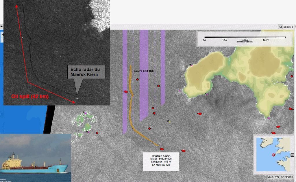

33

34 R/D oil spill Ocean surface slick characterization Sensor integration : analysis result integrated with others system, others data sets Different sensors acquiring at the same time from the same situation Challenge : Observation modelisation forecast Link with environnemental : wind, sea state : current, wave,.. Operationnal Oceanography Remote-sensing / In situ observation Modelling : hindcast, nowcast, forecast
35 IUU fishing ( fr : INN : Illegal, Non reporté, Non régulé ) -Illegal fishing takes place when vessels operate in violation of the laws of fishery Fisheries that under juridiction of local state or high seas fisheries, regulated by Regional Fisheries Management Organisation (RFMO) -Unreported fishing is fishing that has been unreported or misreported to the relevant national authority or RFMO, in contrevention of applicable laws and regulation -Unregulated fishing generally refers to fishing by vessels whitout nationality or vessel flying flag of country not party to RFMO governing thatr fishing area on high seas IUU fishing is the major contributor with negative impact on Economic Environmental Ecological Social

36

37

38 And links with INN

39

40
41 Space-based vessel/target detection and identification - a useful tool for operationnal MDA Oil spill pollution Identification of source, Risk assessment Fisheries control Illegal fishing, Fishing pattern, Effort estimation Safety Maritime traffic density, Accident risk Compliance with traffic separation schemes Search and Rescue Security Border control, illegal immigration, smuggling, piracy.. With technicals and cost issues and Research/Development efforts - New systems ( Sentinel1.. «free» acces?, resolution, swath ) - Sat-AIS ( since Now ~10 satellites) -New techniques ( polarimetry, ) : detection, data fusion
Space Based Vessel Detection - Combining Earth Observation and AIS for Maritime surveillance TEXAS V and C-Σ III
 Space Based Vessel Detection - Combining Earth Observation and AIS for Maritime surveillance TEXAS V and C-Σ III Tony Bauna Director, Product and Service Development, Kongsberg Satellite Services, Tromsø,
Satellite Technologies for Fisheries Monitoring, Control and Surveillance (MCS)
") JRC IPSC Maritime Affairs 1 Satellite Technologies for Fisheries Monitoring, Control and Surveillance (MCS) Juan Cicuendez, Marlene Alvarez JRC Info Day Madrid, 2 June 2010 IPSC - Institute for the Protection
JRC IPSC Maritime Affairs 1 Satellite Technologies for Fisheries Monitoring, Control and Surveillance (MCS) Juan Cicuendez, Marlene Alvarez JRC Info Day Madrid, 2 June 2010 IPSC - Institute for the Protection
PMAR Piracy, Maritime Awareness & Risks
 PMAR Piracy, Maritime Awareness & Risks Maritime Situational Awareness for Counter-Piracy European Commission Joint Research Centre 13 June 2012 GeoMaritime, London 1 MSA for counter-piracy study Key elements
Satellite data for Maritime Operations. Andreas Hay Kaljord Project Manager Energy, Environment & Security
 Satellite data for Maritime Operations Andreas Hay Kaljord Project Manager Energy, Environment & Security Kongsberg Satellite Services (KSAT) World leading provider within our business area Supports 85
Satellite services for maritime security
 Satellite services for ITS-T Sophia Antipolis 6 June 2007 Jean-Pierre Cauzac, CLS - Collecte Localisation Satellites 35 Are the seas becoming more dangerous? IMB report 2006 shows improvement: 239 piracy
KONGSBERG. WORLD CLASS through people, technology and dedication WORLD CLASS through people, technology and dedication
 WORLD CLASS through people, technology and dedication WORLD CLASS through people, technology and dedication Skipsdeteksjon fra radarsatellitter SkipSat Richard Hallr Kongsberg Satellite Services AS (KSAT)
Integration of AIS functionalities
 Integration of AIS functionalities by John O. Klepsvik FARGIS 05 March 01, 2005 WORLD CLASS through people, technology and dedication WORLD CLASS through people, technology and dedication KONGSBERG March
A Space-Based Solution for Illegal, Unregulated & Unreported Fishing. Emmanouil Detsis, International Space University
 Project Catch A Space-Based Solution for Illegal, Unregulated & Unreported Fishing Emmanouil Detsis, International Space University Project Catch COPUOS Presentation Team Project Oceans International Intercultural
KONGSBERG SATELLITE SERVICES Earth Observation for Maritime Operations Current Capabilities and Future Potential
 KONGSBERG SATELLITE SERVICES 2017 Earth Observation for Maritime Operations Current Capabilities and Future Potential Andreas Hay Kaljord Project Manager KSAT HQ IN TROMSØ - 69N WELCOME TO TROMSØ Established
Using satellite technology to monitor illegal, unreported, and unregulated (IUU) fishing
 fishing") Using satellite technology to monitor illegal, unreported, and unregulated (IUU) fishing Mark Richardson The Pew Charitable Trusts Blue Planet Symposium, June 2, 2017 The global threat of IUU fishing Illegal,
Using satellite technology to monitor illegal, unreported, and unregulated (IUU) fishing Mark Richardson The Pew Charitable Trusts Blue Planet Symposium, June 2, 2017 The global threat of IUU fishing Illegal,
Demonstrator of a Data Processing Centre (DPC) for satellite-based AIS services
 for satellite-based AIS services") Page 1 Demonstrator of a Data Processing Centre (DPC) for satellite-based AIS services 19/20 April 2012 gfabritius@cls.fr Overview of the presentation Page 2 Introducing CLS Introducing AIS / SAT-AIS Scope
Page 1 Demonstrator of a Data Processing Centre (DPC) for satellite-based AIS services 19/20 April 2012 gfabritius@cls.fr Overview of the presentation Page 2 Introducing CLS Introducing AIS / SAT-AIS Scope
The Ability of a Small Satellite Constellation to Tip and Cue Other Commercial Assets
 Changing the economics of space The Ability of a Small Satellite Constellation to Tip and Cue Other Commercial Assets Becky Cudzilo - Surrey Satellite US, LLC K.C. Foley - GeoEye, Inc. Chandler Smith -
KONGSBERG SATELLITE SERVICES 2017 Line Steinbakk, Director Programs. Himmel og hav - Ålesund 3. Oktober 2017
 KONGSBERG SATELLITE SERVICES 2017 Line Steinbakk, Director Programs Himmel og hav - Ålesund 3. Oktober 2017 KSAT HQ IN TROMSØ 69N Established in 1967 Kongsberg Satellite Services since 2002 World leading
Co-ReSyF RA lecture: Vessel detection and oil spill detection
 This project has received funding from the European Union s Horizon 2020 Research and Innovation Programme under grant agreement no 687289 Co-ReSyF RA lecture: Vessel detection and oil spill detection
*For International Stewardship of the Maritime Environment and its Resources. Photo
 *For International Stewardship of the Maritime Environment and its Resources *For Maritime Safety *For Security Photo # Providing Environmental Monitoring* # Increasing Security* # Enabling Safety Efforts*
CJ Jagadeesha,NDRF-IEI, Bangalore RM Vasagam,Chairman Aerospace Division Board,IEI LVM Reddy,Vice-President,IEI
 CJ Jagadeesha,NDRF-IEI, Bangalore RM Vasagam,Chairman Aerospace Division Board,IEI LVM Reddy,Vice-President,IEI D] Geo informatics for assessing EWS in watersheds E] DSS for EW communication and policy
Abstract. 1. Introduction
 Title: Satellite surveillance for maritime border monitoring Author: H. Greidanus Number: File: GMOSSBordMon1-2.doc Version: 1-2 Project: GMOSS Date: 25 Aug 2004 Distribution: Abstract Present day remote
Juan GAVIRIA, Sector Leader AFTTR
 Earth Observation in support of the Western Indian Ocean Marine Highway Development and Coastal and Marine Contamination Prevention Project - Oil spill detection & Coral reef monitoring Juan GAVIRIA, Sector
Western Indian Ocean Marine Highway Development and Coastal and Marine Contamination Prevention Project - Oil spill detection & Coral reef monitoring
 Earth Observation in support of the Western Indian Ocean Marine Highway Development and Coastal and Marine Contamination Prevention Project - Oil spill detection & Coral reef monitoring Juan GAVIRIA, Sector
Evaluation of Vessel Detection System Use for Monitoring of Fisheries Activities
 Not to be cited without prior reference to the author Evaluation of Vessel Detection System Use for Monitoring of Fisheries Activities Guido Lemoine, Marte Indregard, Christian Cesena, Francois Xavier
Introduction Objective and Scope p. 1 Generic Requirements p. 2 Basic Requirements p. 3 Surveillance System p. 3 Content of the Book p.
 Preface p. xi Acknowledgments p. xvii Introduction Objective and Scope p. 1 Generic Requirements p. 2 Basic Requirements p. 3 Surveillance System p. 3 Content of the Book p. 4 References p. 6 Maritime
Copyright 2016 Raytheon Company. All rights reserved. Customer Success Is Our Mission is a registered trademark of Raytheon Company.
 Make in India Paradigm : Roadmap for a Future Ready Naval Force Session 9: Coastal Surveillance, Response Systems and Platforms Nik Khanna, President, India April 19, 2016 "RAYTHEON PROPRIETARY DATA THIS
Rutter High Resolution Radar Solutions
 Rutter High Resolution Radar Solutions High Resolution Imagery, Target Detection, and Tracking At the core of our enhanced radar capabilities are proprietary radar processing and imaging technologies.
Graham Stickler Esri Ocean GIS Forum, Redlands, CA, 5-7 November 2013
 Graham Stickler Esri Ocean GIS Forum, Redlands, CA, 5-7 November 2013 Imagine.. A world with no horizons Coastal Coverage Space View Satellite Constellation 6 satellite polar orbiting + 1 equatorial constellation
An Introduction to INDUSTRY PARTNERS 25/05/2017. Military Army & Air Force. Government Defense & Rescue. Aviation Maritime Military. Other.
 An Introduction to 1 INDUSTRY PARTNERS Aviation Maritime Military Coast Guard & Navy Military Army & Air Force Government Defense & Rescue Other Commercial Commercial/Workboat Navy Air Force SAR Agencies
Sensors, Tools and the Common Operating Picture. Sensors, Tools and the Common Operating Picture 14 th April Middleburg
 Sensors, Tools and the Common Operating Picture 14 th April 2015 - Middleburg Aptomar Established in 2005 Owned by Statoil, Investinor, Proventure Seed, Verdane Capitol Have developed and control all IPR
Multi Sensor Data Fusion
 Multi Sensor Data Fusion for improved maritime traffic monitoring in the Canadian Arctic Giulia Battistello*, Martin Ulmke*, Javier Gonzalez*, Camilla Mohrdieck** (*) Fraunhofer FKIE Sensor Data and Information
Innovative Maritime Surveillance Capabilities. Pre-operational Services for Highly. Development of. Maria Angelucci, e-geos
 Development of Pre-operational Services for Highly Innovative Maritime Surveillance Capabilities ASI Workshop - 7 th Framework Program Rome, June 27 th, 2012 Maria Angelucci, e-geos 1 Figures Start date:
Operational use of satellite SAR at EMSA
 Operational use of satellite SAR at EMSA 25 January 2010 SEASAR Workshop ESRIN, Frascati 1 Marin Chintoan-Uta Head of Unit Satellite Based Monitoring Services The structure of the presentation Introduction
Integrating Spaceborne Sensing with Airborne Maritime Surveillance Patrols
 22nd International Congress on Modelling and Simulation, Hobart, Tasmania, Australia, 3 to 8 December 2017 mssanz.org.au/modsim2017 Integrating Spaceborne Sensing with Airborne Maritime Surveillance Patrols
It is an Interconnected World. Except in the Maritime Domain In 2008 Satellite AIS (S-AIS) Changed All that!
 Changed All that!") It is an Interconnected World Except in the Maritime Domain In 2008 Satellite AIS (S-AIS) Changed All that! Background This brief is the result of that Research, which continues to this day. Makes Regional
It is an Interconnected World Except in the Maritime Domain In 2008 Satellite AIS (S-AIS) Changed All that! Background This brief is the result of that Research, which continues to this day. Makes Regional
satellite based maritime awareness and surveillance Italian Coast Guard Headquarters
 satellite based maritime awareness and surveillance THE ITCG S ACTIVITIES ARE PERFORMED FOR: BY LAW ITALIAN COAST GUARD IS RESPONSIBLE FOR: PERFORMING AND COORDINATING MARITIME SEARCH AND RESCUE OPERATIONS
SAR Interferometry Capabilities of Canada's planned SAR Satellite Constellation
 SAR Interferometry Capabilities of Canada's planned SAR Satellite Constellation Dirk Geudtner, Guy Séguin,, Ralph Girard Canadian Space Agency RADARSAT Follow-on Program CSA is in the middle of a Phase
S. Africa Cape Town. S. Africa Australia miles. Maritime Interest 31/07/2013. NAV 2013 Navigation Symposium
 NAV 2013 Navigation Symposium S. Africa Cape Town SESSION 10: Expanding role of Vessel Traffic Services (VTS) Vessel Monitoring in South Africa and Beyond - Why Safety of Navigation? Centre for Sea Watch
PRODUCTS AND SERVICES FOR THE MARITIME COMMUNITY. Ed Martin, Chief Customer Affairs Branch Navigation Services Division Monday, 27 October, 2008
 PRODUCTS AND SERVICES FOR THE MARITIME COMMUNITY Ed Martin, Chief Customer Affairs Branch Navigation Services Division Monday, 27 October, 2008 Coral Reef Conservation International Collaboration Marine
Utilization of Radar data for Maritime Surveillance
 INDESO Project Utilization of Radar data for Maritime Surveillance DENDY MAHABROR MARINE RESEARCH CENTER INDESO RADAR GROUND STATION RADARSAT-2 AND COSMO-SKYMED BALI INDESO satelit VMS satelite radar vessel
SMARTER THAN YOUR AVERAGE SENSOR: AIS SENSOR THAT INTELLIGENTLY RE-TRANSMITS MEANINGFUL INFORMATION DERIVED FROM RAW AIS DATA IN NETWORK LIMITED AREAS
 SMARTER THAN YOUR AVERAGE SENSOR: AIS SENSOR THAT INTELLIGENTLY RE-TRANSMITS MEANINGFUL INFORMATION DERIVED FROM RAW AIS DATA IN NETWORK LIMITED AREAS R. G. V. Meyer a,b, W. Kleynhans a,b, D. Swanepoel
Canadian Space Agency program update
 Canadian Space Agency program update Briefing to the meeting of the Expert Team on Satellite Systems (ET-SAT-11) Geneva, 4 April 2017 Guennadi Kroupnik Canadian Space Agency RADARSAT-2: CURRENT OPERATIONAL
*For International Stewardship of the Maritime Environment and its Resources. Photo
 *For International Stewardship of the Maritime Environment and its Resources *For Maritime Safety *For Security Photo # Providing Environmental Monitoring* # Increasing Security* # Enabling Safety Efforts*
Enhanced Maritime Traffic Picture for the Canadian Arctic
 Enhanced Maritime Traffic Picture for the Canadian Arctic Giulia Battistello*, Martin Ulmke*, Camilla Mohrdieck** (*) Fraunhofer FKIE - Sensor Data and Information Fusion Department - Wachtberg, Germany
GMDSS modernisation and e-navigation: spectrum needs
 ETSI Workshop "Future Evolution of Marine Communication", 7-8 November 2017, Sophia Antipolis, France GMDSS modernisation and e-navigation: spectrum needs Karlis Bogens BR Terrestrial Services Department
REPORT OF THE FOOD AND AGRICULTURE ORGANIZATION CONCERNING UNITED NATIONS GENERAL ASSEMBLY RESOLUTIONS A/RES/57/141 ON OCEANS AND THE LAW OF THE SEA
 REPORT OF THE FOOD AND AGRICULTURE ORGANIZATION CONCERNING UNITED NATIONS GENERAL ASSEMBLY RESOLUTIONS A/RES/57/141 ON OCEANS AND THE LAW OF THE SEA January 2003 In her letter of 16 November 2003 to the
Cost Effective Control of your Coastal Waters
 Cost Effective Control of your Coastal Waters Olov Fäst SSC Airborne Systems 2013-07-03 SSC: A comprehensive space industry Founded in 1972 ~650 employees (2012) ~100 M turnover (2012) Since the start
ESA IAP Blue Belt demonstration project:
 Page 1 ESA IAP Blue Belt demonstration project: supporting the European Maritime Safety Agency (EMSA) Blue Belt Project, by providing a service based on satellite based AIS data complementing the terrestrial
TerraSAR-X Applications Guide
 TerraSAR-X Applications Guide Extract: Maritime Monitoring: Ship Detection April 2015 Airbus Defence and Space Geo-Intelligence Programme Line Maritime Monitoring: Ship Detection Issue Maritime security
The ERS contribution to Oil Spill Monitoring - From R&D towards an operational service -
 The ERS contribution to Oil Spill Monitoring - From R&D towards an operational service - J.P. Pedersen, T.Bauna, L.G. Seljelv, L. Steinbakk, R.T.Enoksen Tromsø Satellite Station, N-9291 Tromsø, Norway
European Commission Workshop «SATELLITE IMAGERY AND ILLEGAL OIL SPILLS IN EUROPE AND IN THE MEDITERRANEAN» Round table 1 : «DETECTION TECHNIQUES»
 European Commission Workshop «SATELLITE IMAGERY AND ILLEGAL OIL SPILLS IN EUROPE AND IN THE MEDITERRANEAN» Round table 1 : «DETECTION TECHNIQUES» Round table 2 : «MUTUAL INFORMATION AND PROSECUTION PROCEDURES»
AIS and SATAIS. AIS is a globally available, mandatory and thus unique information source of each sea going
 AIS and SATAIS AIS is a globally available, mandatory and thus unique information source of each sea going vessel above 299 GRT including MMSI, name, position, speed, direction, cargo type, port of destination
Kongsberg Satellite Services, KSAT
 SvalSat, Earth Station at 78 North Kongsberg Satellite Services, KSAT Making Sense of Space Sigmund Dehli International Sales Manager WORLD CLASS through people, technology and dedication My plan KSAT
Marine mammal monitoring
 Marine mammal monitoring Overseas territories REMMOA campaigns : survey of marine mammals and other pelagic megafauna by aerial observation West Indies French Guiana / Indian Ocean / French Polynesia /
MCS Needs of Developing Countries
 MCS Needs of Developing Countries { Introduction Central Management Increasing fish production and profitability Attracted All manner of investments Easy and unfettered access to fisheries resources and
Copernicus Introduction Lisbon, Portugal 13 th & 14 th February 2014
 Copernicus Introduction Lisbon, Portugal 13 th & 14 th February 2014 Contents Introduction GMES Copernicus Six thematic areas Infrastructure Space data An introduction to Remote Sensing In-situ data Applications
Oil spill detection in the Chinese Seas by spaceborne synthetic aperture radars: challenges and pitfalls (Project: OPAC )
") Oil spill detection in the Chinese Seas by spaceborne synthetic aperture radars: challenges and pitfalls (Project: 10705 OPAC ) Werner Alpers Institute of Oceanography, University of Hamburg, Hamburg,
Oil spill detection in the Chinese Seas by spaceborne synthetic aperture radars: challenges and pitfalls (Project: 10705 OPAC ) Werner Alpers Institute of Oceanography, University of Hamburg, Hamburg,
Microwave Remote Sensing (1)
") Microwave Remote Sensing (1) Microwave sensing encompasses both active and passive forms of remote sensing. The microwave portion of the spectrum covers the range from approximately 1cm to 1m in wavelength.
Microwave Remote Sensing (1) Microwave sensing encompasses both active and passive forms of remote sensing. The microwave portion of the spectrum covers the range from approximately 1cm to 1m in wavelength.
RADARSAT-2 Modes and Applications
 RADARSAT-2 Modes and Applications Gordon Staples MDA Geospatial Services February 6, 2017 1 Introduction RADARSAT-2 was developed to meet operational needs via a versatile space segment and a responsive
SHIP DETECTION AND SEA CLUTTER CHARACTERISATION USING X&L BAND FULL-POLARIMETRIC AIRBORNE SAR DATA
 SHIP DETECTION AND SEA CLUTTER CHARACTERISATION USING X&L BAND FULL-POLARIMETRIC AIRBORNE SAR DATA S. Angelliaume, Ph. Martineau (ONERA) Ph. Durand, T. Cussac (CNES) Context CNES/ONERA study of Space System
Coastal Surveillance. SCANTER Radar Solutions
 Coastal Surveillance SCANTER Radar Solutions Protecting Your Coastlines and Maritime Domain We provide radar coverage of the coastline to detect and track all types of surface vessels and air targets.
GNSS in Maritime and Education in Egypt
 GNSS in Maritime and Education in Egypt GNSS IN MARITIME PORTS SHIPS PORTS WATERWAYS GNSS maritime applications will help to improve: navigation. Ship operations. Traffic management. Seaport operations.
Author s Name Name of the Paper Session. DYNAMIC POSITIONING CONFERENCE October 10-11, 2017 SENSORS SESSION. Sensing Autonomy.
 Author s Name Name of the Paper Session DYNAMIC POSITIONING CONFERENCE October 10-11, 2017 SENSORS SESSION Sensing Autonomy By Arne Rinnan Kongsberg Seatex AS Abstract A certain level of autonomy is already
Canada s. Third. Generation. High Frequency. Surface Wave. Radar System
 Canada s Third Generation High Frequency Surface Wave Radar System by Peter Moo, Tony Ponsford, David DiFilippo, Rick McKerracher, Nathan Kashyap, and Yannick Allard Introduction The granting of coastal
e-navigation Underway International February 2016 Kilyong Kim(GMT Co., Ltd.) Co-author : Seojeong Lee(Korea Maritime and Ocean University)
 Co-author : Seojeong Lee(Korea Maritime and Ocean University)") e-navigation Underway International 2016 2-4 February 2016 Kilyong Kim(GMT Co., Ltd.) Co-author : Seojeong Lee(Korea Maritime and Ocean University) Eureka R&D project From Jan 2015 to Dec 2017 15 partners
e-navigation Underway International 2016 2-4 February 2016 Kilyong Kim(GMT Co., Ltd.) Co-author : Seojeong Lee(Korea Maritime and Ocean University) Eureka R&D project From Jan 2015 to Dec 2017 15 partners
COMMUNICATIONS FOR MARITIME SAFETY AND EFFICIENCY. Francis Zachariae, Secretary-General, IALA
 COMMUNICATIONS FOR MARITIME SAFETY AND EFFICIENCY Francis Zachariae, Secretary-General, IALA IALA and its Purpose Non profit, international technical association established in 1957 Two Goals aimed at
This circular summarizes the various important aspects of the LRIT system with a view to enabling companies to ensure compliance in a timely manner.
 Luxembourg, 29/10/2008 CIRCULAR CAM 02/2008 N/Réf. : AH/63353 Subject : Long-Range Identification and Tracking of Ships (LRIT) To : All ship owners, ship operators and designated persons of Luxembourg
Downloaded by on April 16, DOI: /
 Polar Epsilon: Joint Space-Based Wide Area Surveillance and Support Project LCdr Robert Quinn Project Director Polar Epsilon Directorate of Space Development Phone: +1(613)945-5212 Quinn.rj2@forces.gc.ca
the use of satellite radar to improve surveillance of oil pollution over large areas
 Groupe de travail ORFEO - Mer et Littoral Réunion du 14 octobre 2004 the use of satellite radar to improve surveillance of oil pollution over large areas François Parthiot Cedre - Delegate for the Mediterranean
Arctic Shipping Navigating the Legal Landscape for marine infrastructure and Off-Shore Development
 Arctic Shipping Navigating the Legal Landscape for marine infrastructure and Off-Shore Development Peter G. Pamel Partner Connecticut Maritime Association SHIPPING 2012 Hilton Stamford March 21 st, 2012
Session 8: Maritime Safety and Security. Raymond Gilpin, Ph.D. Academic Dean. Impact through Insight
 Session 8: Maritime Safety and Security Raymond Gilpin, Ph.D. Academic Dean Impact through Insight Africa s Maritime Environment Abundant natural resources: Significant fishing grounds Growing interest
NEREIDS: New concepts in maritime surveillance for consolidating operational developments
 SEASAR12 WORKSHOP, TROMSO, 06-12 NEREIDS: New concepts in maritime surveillance for consolidating operational developments Property of GMV All rights reserved SUMMARY NEREIDS PROJECT NEREIDS CHALLENGES
SUGAR_GIS. From a user perspective. Provides spatial distribution of a wide range of sugarcane production data in an easy to use and sensitive way.
 SUGAR_GIS From a user perspective What is Sugar_GIS? A web-based, decision support tool. Provides spatial distribution of a wide range of sugarcane production data in an easy to use and sensitive way.
HSE and Quality. Sisimiut, 10th December FING: Arctic Region Oil & Gas Seminar in Training and Education
 HSE and Quality Sisimiut, 10th December 2013 FING: Arctic Region Oil & Gas Seminar in Training and Education 1 Arctic Issues Above ground challenges FING: Arctic Region Oil & Gas Seminar in Training and
ERS/ENVISAT ASAR Data Products and Services
 ERS/ENVISAT ASAR Data Products and Services Andrea Celentano Business Manager celentan@eurimage.com What is Eurimage? Founded in 1989 Current shareholders: Since 1989 Commercial Partner of the European
Using a Data Fusion-based Activity Recognition Framework to Determine Surveillance System Requirements
 Using a Data Fusion-based Activity Recognition Framework to Determine Surveillance System Requirements Willem H. le Roux and Jan J. Nel Council for Scientific and Industrial Research Pretoria, South Africa
EE 529 Remote Sensing Techniques. Introduction
 EE 529 Remote Sensing Techniques Introduction Course Contents Radar Imaging Sensors Imaging Sensors Imaging Algorithms Imaging Algorithms Course Contents (Cont( Cont d) Simulated Raw Data y r Processing
Mission Solution 100
 Mission Solution 100 Standard configuration for littoral security Member of the Thales Mission Solution family Standard configuration of integrated sensors, effectors, CMS, communication system and navigation
Security Systems Division
 Security Systems Division SIVE A PIONEER MARITIME BORDER SURVEILLANCE SYSTEM. WHAT IS BEYOND? Pros and cons of the SIVE system today in the new coastal and deepwater border scenario and our vision of a
Consultation on International Ocean Governance
 Consultation on International Ocean Governance 1 Context Oceans are a key source of nutritious food, medicine, minerals and renewable energy. They are also home to a rich, fragile, and largely unknown
Earth Observation Opportunities to Enhance Maritime Safety
 http://www.transnav.eu the International Journal on Marine Navigation and Safety of Sea Transportation Volume 11 Number 4 December 2017 DOI: 10.12716/1001.11.04.17 Earth Observation Opportunities to Enhance
Special Projects Office. Mr. Lee R. Moyer Special Projects Office. DARPATech September 2000
 Mr. Lee R. Moyer DARPATech 2000 6-8 September 2000 1 CC&D Tactics Pose A Challenge to U.S. Targeting Systems The Challenge: Camouflage, Concealment and Deception techniques include: Masking: Foliage cover,
Collaborative use of SAR and AIS data from NovaSAR-S for Maritime Surveillance
 Collaborative use of SAR and AIS data from NovaSAR-S for Maritime Surveillance Lotfi Achiri, University of Surrey, Surrey Space Centre, l.achiri@surrey.ac.uk, UK Raffaella Guida, University of Surrey,
Satellite SAR ship detections from PMAR in support of Cutlass Express
 Satellite SAR ship detections from PMAR in support of Cutlass Express Harm Greidanus, Marlene Alvarez, Tulay Cokacar, Andrea Pesaresi, Carlos Santamaria, Vladimir Kyovtorov EUR 25140 EN - 2011 The mission
Dimov Stojče Ilčev. CNS Systems
 Stratospheric Platform Systems (SPS) Presentation by: Dimov Stojče Ilčev Durban University of Technology (DUT) Space Science Centre (SSC) CNS Systems August 2011 SPS for Mobile CNS Applications Stratospheric
CHAPTER 1 INTRODUCTION
 1 CHAPTER 1 INTRODUCTION In maritime surveillance, radar echoes which clutter the radar and challenge small target detection. Clutter is unwanted echoes that can make target detection of wanted targets
Recent Developments in NOAA s Real- Time Coastal Observing Systems for Safe and Efficient Maritime Transportation
 Recent Developments in NOAA s Real- Time Coastal Observing Systems for Safe and Efficient Maritime Transportation Rich Edwing, Director NOAA Center for Operational Oceanographic Products and Services CMTS
Towards a Management Plan for a Tropical Reef-Lagoon System Using Airborne Multispectral Imaging and GIS
 Towards a Management Plan for a Tropical Reef-Lagoon System Using Airborne Multispectral Imaging and GIS This paper was presented at the Fourth International Conference on Remote Sensing for Marine and
Briefing NMFS proposal to revise regulations concerning the use and approval of scales for weighing catch at-sea.
 Briefing NMFS proposal to revise regulations concerning the use and approval of scales for weighing catch at-sea. OVERVIEW The use of at-sea scales can provide very precise and potentially accurate estimates
APPLICATION OF REMOTE SENSING DATA FOR OIL SPILL MONITORING IN THE GUANABARA BAY, RIO DE JANEIRO, BRAZIL
 APPLICATION OF REMOTE SENSING DATA FOR OIL SPILL MONITORING IN THE GUANABARA BAY, RIO DE JANEIRO, BRAZIL CRISTINA MARIA BENTZ 1 FERNANDO PELLON DE MIRANDA 1 1 PETROBRAS/CEGEQ (Center of Excellence in Geochemistry
CASE STUDY OF THE ICELANDIC INTEGRATED SYSTEM FOR MONITORING, CONTROL AND SURVEILLANCE
 FAO Fisheries and Aquaculture Circular No. 1053 FIRO/C1053 (En) ISSN 2070-6065 CASE STUDY OF THE ICELANDIC INTEGRATED SYSTEM FOR MONITORING, CONTROL AND SURVEILLANCE Copies of FAO publications can be requested
IUU Fishing Detection
 Illegal, Unreported, Unregulated IUU Fishing Detection Jarred Byrnes Jonathan Matteson Edward Kerrigan Jonathan Gessert Link to presentation on Google Slides: https://docs.google.com/presentation/d/ 16EigEHtQt8Hmfu1er4OkoMwVAMGN
THE modern airborne surveillance and reconnaissance
 INTL JOURNAL OF ELECTRONICS AND TELECOMMUNICATIONS, 2011, VOL. 57, NO. 1, PP. 37 42 Manuscript received January 19, 2011; revised February 2011. DOI: 10.2478/v10177-011-0005-z Radar and Optical Images
MSRC Tactical Oil Spill Surveillance and Remote Sensing
 MSRC Tactical Oil Spill Surveillance and Remote Sensing Industry Technical Advisory Committee for Oil spill Response October 25, 2016 0 Historical Perspective -- Oil Spill Surveillance in U.S Exxon Valdez
The Pitcairn Islands Marine Reserve A global benchmark in marine protection
 A fact sheet from March 2015 The Pitcairn Islands Marine Reserve A global benchmark in marine protection Overview In September 2016, the United Kingdom created a fully protected marine reserve spanning
David Franc. Department of Commerce Office of Radio Frequency Management
 David Franc Department of Commerce Office of Radio Frequency Management Oceanographic Radar Outline What It Does Some Examples What It Looks Like How It Works How Much It Costs Spectrum Considerations
RADAR SATELLITES AND MARITIME DOMAIN AWARENESS
 RADAR SATELLITES AND MARITIME DOMAIN AWARENESS J.K.E. Tunaley Corporation, 114 Margaret Anne Drive, Ottawa, Ontario K0A 1L0 (613) 839-7943 Report Documentation Page Form Approved OMB No. 0704-0188 Public
Marine Earth Observation & Applications at University College Cork
 Marine Earth Observation & Applications at University College Cork Rory Scarrott, with input from Eimear Tuohy & Chiara Pratola 2 nd Irish Industry Space Day, Hibernian Club, Dublin, September 2 nd 2015
Observing Dry-Fallen Intertidal Flats in the German Bight Using ALOS PALSAR Together With Other Remote Sensing Sensors
 Observing Dry-Fallen Intertidal Flats in the German Bight Using ALOS PALSAR Together With Other Remote Sensing Sensors Martin Gade, Institut für Meereskunde & Kerstin Stelzer Brockmann Consult Outline
RESOLUTION MSC.229(82) (adopted on 5 December 2006) ADOPTION OF A NEW MANDATORY SHIP REPORTING SYSTEM "IN THE GALAPAGOS PARTICULARLY SENSITIVE SEA
 (adopted on 5 December 2006) ADOPTION OF A NEW MANDATORY SHIP REPORTING SYSTEM IN THE GALAPAGOS PARTICULARLY SENSITIVE SEA") MSC 82/24/Add.2 RESOLUTION MSC.229(82) IN THE GALAPAGOS PARTICULARLY SENSITIVE SEA AREA (PSSA) (GALREP) THE MARITIME SAFETY COMMITTEE, RECALLING Article 28(b) of the Convention on the International Maritime
MSC 82/24/Add.2 RESOLUTION MSC.229(82) IN THE GALAPAGOS PARTICULARLY SENSITIVE SEA AREA (PSSA) (GALREP) THE MARITIME SAFETY COMMITTEE, RECALLING Article 28(b) of the Convention on the International Maritime
ORBCOMM Machine-To-Machine (M2M)
") ORBCOMM Machine-To-Machine (M2M) Texas V & C-Sigma November 2012 Global M2M Connecting the World s Assets Machine-To-Machine (M2M) Applications Global M2M Wireless Network for Narrowband Data Applications
ORBCOMM Machine-To-Machine (M2M) Texas V & C-Sigma November 2012 Global M2M Connecting the World s Assets Machine-To-Machine (M2M) Applications Global M2M Wireless Network for Narrowband Data Applications
MARINE ELECTRONIC HIGHWAY IN STRAITS OF MALACCA AND SINGAPORE. Development of Supporting Element for Future & Sustainable Operation
 COOPERATION FORUM UNDER THE COOPERATIVE MECHANISM ON SAFETY OF NAVIGATION AND ENVIRONMENTAL PROTECTION IN THE STRAITS OF MALACCA AND SINGAPORE 7th SESSION Agenda Item... CF 7/... 22-23 September 2014 Original.
Development of Microsatellite to Detect Illegal Fishing MS-SAT
 Development of Microsatellite to Detect Illegal Fishing MS-SAT Ernest S. C. P. Bintang A.S.W.A.M. Department of Aerospace Engineering Faculty of Mechanical and Aerospace Engineering Institut Teknologi
Government Agency Perspectives & Initiatives Canadian Coast Guard Laurent Tardif, Director, Safe Shipping
 Unclassified Government Agency Perspectives & Initiatives Canadian Coast Guard Laurent Tardif, Director, Safe Shipping Mariner s Workshop January 23, 2019 1 Overview 1 Context 2 Marine Fees 3 4 5 Update