Cost Effective Control of your Coastal Waters
|
|
|
- Melvyn Newman
- 5 years ago
- Views:
Transcription

1 Cost Effective Control of your Coastal Waters Olov Fäst SSC Airborne Systems
 ~100 M turnover")
2 SSC: A comprehensive space industry Founded in 1972 ~650 employees (2012) ~100 M turnover (2012)

3 Since the start in 1972 SSC has launched 6 scientific satellites Swedish Space Corporation
4 500 sounding rockets to 700 km altitude

5 550 high-altitude balloons - up to 1,2 million m 3 volume

6 satellite contacts per year! using 9 antennas

7 SSC Airborne Systems SSC Maritime Surveillance Systems used in >20 countries for: EEZ (Economic Zone Protection) Environmental Protection/ Oil pollution Border and fishery control Ship traffic management Search and rescue Ice patrol

8 1970 s: Oil Spill detection

9 1980 s: Oil spills + general surveillance Swedish Coast Guard CASA 212

10 1990 s: Fishery patrol: Three CASA equipped for the Portuguese Air Force

11 Installations For more than 30 years our systems have operated on different types of aircraft in Sweden Norway Poland Greece USA Portugal Canada Estonia India Finland Malaysia.
12 Indian Coast Guard Indian Coast Guard- Dornier 228 December 2009

13 Bombardier 415 for MMEA Malaysia 2010

14 MSS 6000 system with integrated: SLAR, FLIR, AIS, DF, Cameras, SATCOM

15 MSS 6000 on Transport Canada Dash 8 In operation since December 2006 Photo Paul Minnaar, Transport Canada

16 MSS 6000 operated by Transport Canada SLAR IR/UV line scanner AIS EO/IR (FLIR) Still camera Video camera SATCOM Direction Finder Recording data with the Dash 8 flying over the Gulf of Mexico Photo: CBC-TV

17 Correlated observation and documentation


18 Pictures by courtesy of ESA, Inmarsat and the Finnish Border Guard Telecom Satellite (Inmarsat) Effectively coordinated operations EO Satellite (Envisat) background data Aircraft surveillance detection of anomalies identification analysis and interpretation report data link for images, reports and orders overview coordination decision control rescue control sampling clean-up rescue Command post Ship
19 Finnish Border Guard- Dornier 228 Multi-mission upgrade in 2012


20 MSS 6000 upgrade in 2012 Communication & reporting Dual Operator consoles AIS Search Radar Cameras DF SLAR IR/UV Scanner EO/IR


21 MSS 6000 system with integrated: Search radar, SLAR, IR/UV, AIS, Cameras, Satcom, FLIR, DF

22 Satellite image integration

23 Gulf of Mexico oil spill in 2010 Transport Canada operated their MSS 6000 equipped Dash 8 over the Gulf of Mexico spill in May - June 2010 Surveillance flights twice a day Invaluable support to response operations

24 Gulf of Mexico oil spill on May 3 Overview of the spill produced on the day of arrival by Transport Canada s aircraft using the SLAR sensor

25 Oil spill on 13 June

26 CLEAN UP OPERATIONS SUPPORT Coordinates of recoverable oil sent to command centre for managing surface clean up operations
 Radar and map images,")

27 Communication and reporting Satellite data transmission system (high-speed INMARSAT) Radar and map images, photos, reports to command centre during flight Command centre SLAR radar image with geographic references (GeoTIFF)


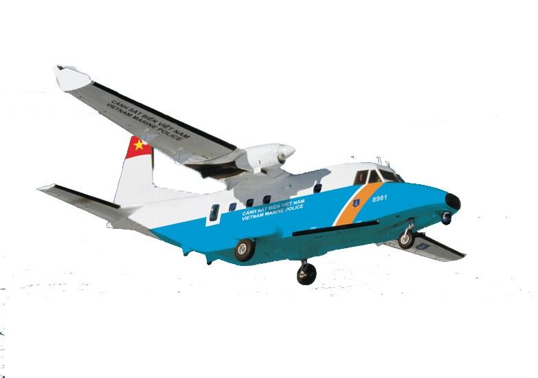
28 MSS 6000 for the Vietnam Marine Police
29 Data transmission network HF transmission Receives: Mission order from MCC Sends: Position data Incident report, optional pictures Streaming video SATCOM Inmarsat S-band transmission Mission Command Center Receives: Mission order from MCC Sends: Position data Incident report, optional pictures Streaming video Receives: Position data Incident report, optional pictures Streaming video Sends: Mission order to aircraft Receives: Mission order from MCC Sends: Position data Incident report, optional pictures Streaming video MCC Removable disk After-action report for archive or replay in MCC HF modem Mission data After-action report After mission printout After mission DVD S-band receiver Operator Operator Operator

30 MSS 6000 Mission Command Centre

31 Mission overview at the MCC

32 MSS 6000 for Vietnam Marine Police 2012 The first of three CASA aircraft for Vietnam Marine Police equipped with the MSS 6000

33 ENABLING YOU TO CONTROL AND PROTECT YOUR WATERS
Satellite services for maritime security
 Satellite services for ITS-T Sophia Antipolis 6 June 2007 Jean-Pierre Cauzac, CLS - Collecte Localisation Satellites 35 Are the seas becoming more dangerous? IMB report 2006 shows improvement: 239 piracy
REFERENCES FAO FAO FAO/FishCode Flewwelling, P Flewwelling, P., Cullinan, C., Balton, D. & Reynolds, J.E Gallagher, R Kelleher, K
 40 REFERENCES FAO. 1998. Fish operations. 1. Vessel monitoring systems. FAO Technical Guidelines for Responsible Fisheries No. 1, Suppl. 1. Rome. 58 pp. FAO. 2007. Report of the Expert Consultation on
2012 PRODUCT INFORMATION SHEET. EagleEye 350 Multi-Role, Special Missions Aerial Surveillance Platform
 2012 PRODUCT INFORMATION SHEET EagleEye 350 Multi-Role, Special Missions Aerial Surveillance Platform The EagleEye 350 is a unique, highly-capable Airborne Multi-Role, Multi-Sensor, Special Missions -
Copyright 2016 Raytheon Company. All rights reserved. Customer Success Is Our Mission is a registered trademark of Raytheon Company.
 Make in India Paradigm : Roadmap for a Future Ready Naval Force Session 9: Coastal Surveillance, Response Systems and Platforms Nik Khanna, President, India April 19, 2016 "RAYTHEON PROPRIETARY DATA THIS
SAR Interferometry Capabilities of Canada's planned SAR Satellite Constellation
 SAR Interferometry Capabilities of Canada's planned SAR Satellite Constellation Dirk Geudtner, Guy Séguin,, Ralph Girard Canadian Space Agency RADARSAT Follow-on Program CSA is in the middle of a Phase
Leadership built upon facts Cobham SATCOM Maritime communication solutions
 Friday, 10 April 2015 The most important thing we build is trust MARINE FleetBroadband VSAT solutions Satellite TV GMDSS VHF and MF/HF radios AIS, Navtex LAND BGAN Portable and Vehicular terminals VSAT
Space Based Vessel Detection - Combining Earth Observation and AIS for Maritime surveillance TEXAS V and C-Σ III
 Space Based Vessel Detection - Combining Earth Observation and AIS for Maritime surveillance TEXAS V and C-Σ III Tony Bauna Director, Product and Service Development, Kongsberg Satellite Services, Tromsø,
Cobham SATCOM Marine. Chris Insall Manager, Commercial Programmes. Hamburg, 28 th Feb Digital Ship Hamburg - 28 February 2013
 Digital Ship Hamburg - 28 February 2013 The most important thing we build is trust AEROSPACE AND SECURITY DIVISION Aerospace Communications Antenna Systems Commercial Systems SATCOM Tactical Communications
ROUTEING OF SHIPS, SHIP REPORTING AND RELATED MATTERS. New traffic separation schemes and two-way routes in Norra Kvarken
 E SUB-COMMITTEE ON SAFETY OF NAVIGATION 57th session Agenda item 3 NAV 57/3/7 11 March 2011 Original: ENGLISH ROUTEING OF SHIPS, SHIP REPORTING AND RELATED MATTERS New traffic separation schemes and two-way
Juan GAVIRIA, Sector Leader AFTTR
 Earth Observation in support of the Western Indian Ocean Marine Highway Development and Coastal and Marine Contamination Prevention Project - Oil spill detection & Coral reef monitoring Juan GAVIRIA, Sector
Western Indian Ocean Marine Highway Development and Coastal and Marine Contamination Prevention Project - Oil spill detection & Coral reef monitoring
 Earth Observation in support of the Western Indian Ocean Marine Highway Development and Coastal and Marine Contamination Prevention Project - Oil spill detection & Coral reef monitoring Juan GAVIRIA, Sector
SERVICES ENABLED BY HIGN ALTITUDE PSEUDO SATELLITES (HAPS) COMPLEMENTED BY SATELLITES : Webinar
 COMPLEMENTED BY SATELLITES : Webinar") Ref. ESA-TIAA-HO-2017-1162 SERVICES ENABLED BY HIGN ALTITUDE PSEUDO SATELLITES (HAPS) COMPLEMENTED BY SATELLITES : Webinar 15/09/2017 Rita Rinaldo, Laurence Duquerroy Downstream Business Applications Department
Ref. ESA-TIAA-HO-2017-1162 SERVICES ENABLED BY HIGN ALTITUDE PSEUDO SATELLITES (HAPS) COMPLEMENTED BY SATELLITES : Webinar 15/09/2017 Rita Rinaldo, Laurence Duquerroy Downstream Business Applications Department
Mission Solution 100
 Mission Solution 100 Standard configuration for littoral security Member of the Thales Mission Solution family Standard configuration of integrated sensors, effectors, CMS, communication system and navigation
Demonstrator of a Data Processing Centre (DPC) for satellite-based AIS services
 for satellite-based AIS services") Page 1 Demonstrator of a Data Processing Centre (DPC) for satellite-based AIS services 19/20 April 2012 gfabritius@cls.fr Overview of the presentation Page 2 Introducing CLS Introducing AIS / SAT-AIS Scope
Page 1 Demonstrator of a Data Processing Centre (DPC) for satellite-based AIS services 19/20 April 2012 gfabritius@cls.fr Overview of the presentation Page 2 Introducing CLS Introducing AIS / SAT-AIS Scope
OIL SPILLS IN ICE Remote Sensing
 OIL SPILLS IN ICE Remote Sensing Technology Overview and Upcoming JIP Research David Dickins Chevron IOSC2014 Savannah COLLABORATION AMONG TEN COMPANIES International arctic research programme Builds upon
Abstract. 1. Introduction
 Title: Satellite surveillance for maritime border monitoring Author: H. Greidanus Number: File: GMOSSBordMon1-2.doc Version: 1-2 Project: GMOSS Date: 25 Aug 2004 Distribution: Abstract Present day remote
Satellite data for Maritime Operations. Andreas Hay Kaljord Project Manager Energy, Environment & Security
 Satellite data for Maritime Operations Andreas Hay Kaljord Project Manager Energy, Environment & Security Kongsberg Satellite Services (KSAT) World leading provider within our business area Supports 85
KONGSBERG SATELLITE SERVICES Earth Observation for Maritime Operations Current Capabilities and Future Potential
 KONGSBERG SATELLITE SERVICES 2017 Earth Observation for Maritime Operations Current Capabilities and Future Potential Andreas Hay Kaljord Project Manager KSAT HQ IN TROMSØ - 69N WELCOME TO TROMSØ Established
*For International Stewardship of the Maritime Environment and its Resources. Photo
 *For International Stewardship of the Maritime Environment and its Resources *For Maritime Safety *For Security Photo # Providing Environmental Monitoring* # Increasing Security* # Enabling Safety Efforts*
Sensors, Tools and the Common Operating Picture. Sensors, Tools and the Common Operating Picture 14 th April Middleburg
 Sensors, Tools and the Common Operating Picture 14 th April 2015 - Middleburg Aptomar Established in 2005 Owned by Statoil, Investinor, Proventure Seed, Verdane Capitol Have developed and control all IPR
1. Detect and locate potentially illegal fishing ship using satellite image, AIS data, and external sources.
 Title: Development of Microsatellite to Detect Illegal Fishing MS-SAT Primary Point of Contact (POC) & email: Dr. Ridanto Eko Poetro; ridanto@ae.itb.ac.id Co-authors: Ernest Sebastian C., Bintang A.S.W.A.M.
Helcom Submerged. Status of the Chapter 3 Wrecks. Jorma Rytkönen. Jari Rintamaa. Finnish Environment Institute
 Helcom Submerged Status of the Chapter 3 Wrecks HELCOM Submerged 22-23 April 2015 Bonn, Germany Jorma Rytkönen Jari Rintamaa Finnish Environment Institute Photo: Finnish Border Guard) Contents Lessons
Rutter High Resolution Radar Solutions
 Rutter High Resolution Radar Solutions High Resolution Imagery, Target Detection, and Tracking At the core of our enhanced radar capabilities are proprietary radar processing and imaging technologies.
KONGSBERG SATELLITE SERVICES 2017 Line Steinbakk, Director Programs. Himmel og hav - Ålesund 3. Oktober 2017
 KONGSBERG SATELLITE SERVICES 2017 Line Steinbakk, Director Programs Himmel og hav - Ålesund 3. Oktober 2017 KSAT HQ IN TROMSØ 69N Established in 1967 Kongsberg Satellite Services since 2002 World leading
Kongsberg Satellite Services, KSAT
 SvalSat, Earth Station at 78 North Kongsberg Satellite Services, KSAT Making Sense of Space Sigmund Dehli International Sales Manager WORLD CLASS through people, technology and dedication My plan KSAT
AIS and SATAIS. AIS is a globally available, mandatory and thus unique information source of each sea going
 AIS and SATAIS AIS is a globally available, mandatory and thus unique information source of each sea going vessel above 299 GRT including MMSI, name, position, speed, direction, cargo type, port of destination
Co-ReSyF RA lecture: Vessel detection and oil spill detection
 This project has received funding from the European Union s Horizon 2020 Research and Innovation Programme under grant agreement no 687289 Co-ReSyF RA lecture: Vessel detection and oil spill detection
TACTICALL MARITIME COMMUNICATION SOLUTION
 TACTICALL MARITIME COMMUNICATION SOLUTION TACTICALL MARITIME COMMUNICATION SOLUTION > FEATURE OVERVIEW TACTICALL MARITIME COMMUNICATION SOLUTION With TactiCall MCS Saab applies already proven integrated
VIIIth European Interparliamentary Space. Mr. Rainer Grohe Executive Director Galileo Joint Undertaking
 The European Institutional Framework for Galileo VIIIth European Interparliamentary Space Conference Mr. Rainer Grohe Executive Director Galileo Joint Undertaking Brussels, 12th June 2006 Galileo Architecture
Proud supporter of the IRMF and the G4 - International Maritime Mass Rescue Conference
 Proud supporter of the IRMF and the G4 - International Maritime Mass Rescue Conference - 2017 Corporate Presentation 6/27/2017 1 OROLIA PROFILE $100m Founded in October 2006 in France, Head Office in Washington
Coastal Surveillance. SCANTER Radar Solutions
 Coastal Surveillance SCANTER Radar Solutions Protecting Your Coastlines and Maritime Domain We provide radar coverage of the coastline to detect and track all types of surface vessels and air targets.
An Introduction to INDUSTRY PARTNERS 25/05/2017. Military Army & Air Force. Government Defense & Rescue. Aviation Maritime Military. Other.
 An Introduction to 1 INDUSTRY PARTNERS Aviation Maritime Military Coast Guard & Navy Military Army & Air Force Government Defense & Rescue Other Commercial Commercial/Workboat Navy Air Force SAR Agencies
The Nordic Institute of Navigation (NNF)
") The Nordic Institute of Navigation (NNF) www.nornav.org non-profit, independent and a non-political organization for professionals working within the field of navigation. The focus of NNF is on all aspects
The Nordic Institute of Navigation (NNF) www.nornav.org non-profit, independent and a non-political organization for professionals working within the field of navigation. The focus of NNF is on all aspects
PMAR Piracy, Maritime Awareness & Risks
 PMAR Piracy, Maritime Awareness & Risks Maritime Situational Awareness for Counter-Piracy European Commission Joint Research Centre 13 June 2012 GeoMaritime, London 1 MSA for counter-piracy study Key elements
Customer Showcase > Defense and Intelligence
 Customer Showcase Skyline TerraExplorer is a critical visualization technology broadly deployed in defense and intelligence, public safety and security, 3D geoportals, and urban planning markets. It fuses
BORIS A Common Situation Awareness System for Finnish Authorities Participating in Oil Spill Response. In official service since the beginning of 2013
 Meri Hietala, Samuli Neuvonen, Kati Tahvonen Finnish Environment Institute 15.8.2013 BORIS A Common Situation Awareness System for Finnish Authorities Participating in Oil Spill Response In official service
Oil spill detection in the Chinese Seas by spaceborne synthetic aperture radars: challenges and pitfalls (Project: OPAC )
") Oil spill detection in the Chinese Seas by spaceborne synthetic aperture radars: challenges and pitfalls (Project: 10705 OPAC ) Werner Alpers Institute of Oceanography, University of Hamburg, Hamburg,
Oil spill detection in the Chinese Seas by spaceborne synthetic aperture radars: challenges and pitfalls (Project: 10705 OPAC ) Werner Alpers Institute of Oceanography, University of Hamburg, Hamburg,
NOT FOR REPRODUCTION. Affordable, multi-mission radar surveillance networks for marine and port security. by Tim J. Nohara
 by Tim J. Nohara NOT FOR REPRODUCTION Affordable, multi-mission radar surveillance networks for marine and port security Introduction The events of September 11, 2001, have focused the efforts of various
Space-Based AIS: Contributing to Global Safety and Security
 Space-Based AIS: Contributing to Global Safety and Security J.S. Cain 1, E. Meger 2, COM DEV Limited 155 Sheldon Ave, Cambridge, Ontario, Canada. Abstract Global trade continues to increase and today more
EDA s PROJECT TEAM EUROPEAN MARITIME CAPABILITIES IN THE ARCTIC PT EMCA
 EDA s PROJECT TEAM EUROPEAN MARITIME CAPABILITIES IN THE ARCTIC PT EMCA WHY EU IN THE ARCTIC? - Climate Change still a puzzle -> to gain better understanding - Arctic s economical importance growing ->
HALS-H1 Ground Surveillance & Targeting Helicopter
 ARATOS-SWISS Homeland Security AG & SMA PROGRESS, LLC HALS-H1 Ground Surveillance & Targeting Helicopter Defense, Emergency, Homeland Security (Border Patrol, Pipeline Monitoring)... Automatic detection
The Convair 580 SAR Facility Recent Activities and Future Opportunities
 The Convair 580 SAR Facility Recent Activities and Future Opportunities Dr. Carl E. Brown Emergencies Science and Technology Section Environment Canada Ottawa, Ontario ESTS Airborne Remote Sensing DC-3,
Towards a Management Plan for a Tropical Reef-Lagoon System Using Airborne Multispectral Imaging and GIS
 Towards a Management Plan for a Tropical Reef-Lagoon System Using Airborne Multispectral Imaging and GIS This paper was presented at the Fourth International Conference on Remote Sensing for Marine and
MANNED AIRBORNE REAL-TIME SURVEILLANCE OBSERVATION SYSTEM
 MARSO WWW.MARSO.AERO MANNED AIRBORNE REAL-TIME SURVEILLANCE OBSERVATION & SYSTEM THE MARSO SYSTEM is a versatile surveillance system for a large class of missions ranging from large area ship detection
Design of an Airborne SLAR Antenna at X-Band
 Design of an Airborne SLAR Antenna at X-Band Markus Limbach German Aerospace Center (DLR) Microwaves and Radar Institute Oberpfaffenhofen WFMN 2007, Markus Limbach, Folie 1 Overview Applications of SLAR
RESOLUTION MSC.278(85) (adopted on 1 December 2008) ADOPTION OF THE NEW MANDATORY SHIP REPORTING SYSTEM "OFF THE COAST OF PORTUGAL - COPREP"
 (adopted on 1 December 2008) ADOPTION OF THE NEW MANDATORY SHIP REPORTING SYSTEM OFF THE COAST OF PORTUGAL - COPREP") MSC 85/26/Add.1 RESOLUTION MSC.278(85) SYSTEM OFF THE COAST OF PORTUGAL COPREP THE MARITIME SAFETY COMMITTEE, RECALLING Article 28 of the Convention on the International Maritime Organization concerning
MSC 85/26/Add.1 RESOLUTION MSC.278(85) SYSTEM OFF THE COAST OF PORTUGAL COPREP THE MARITIME SAFETY COMMITTEE, RECALLING Article 28 of the Convention on the International Maritime Organization concerning
*For International Stewardship of the Maritime Environment and its Resources. Photo
 *For International Stewardship of the Maritime Environment and its Resources *For Maritime Safety *For Security Photo # Providing Environmental Monitoring* # Increasing Security* # Enabling Safety Efforts*
Identification of Oil Spills from offshore installations.
 Identification of Oil Spills from offshore installations. Presentation of methods and preliminary results from the OSIS, Oil Spill Identification Sensor project. By: Jesper Holst OSIS International Tirsbaekvej
Integration of AIS functionalities
 Integration of AIS functionalities by John O. Klepsvik FARGIS 05 March 01, 2005 WORLD CLASS through people, technology and dedication WORLD CLASS through people, technology and dedication KONGSBERG March
CODAR. Ben Kravitz September 29, 2009
 CODAR Ben Kravitz September 29, 2009 Outline What is CODAR? Doppler shift Bragg scatter How CODAR works What CODAR can tell us What is CODAR? Coastal Ocean Dynamics Application Radar Land-based HF radar
Introduction to KOMPSAT
 Introduction to KOMPSAT September, 2016 1 CONTENTS 01 Introduction of SIIS 02 KOMPSAT Constellation 03 New : KOMPSAT-3 50 cm 04 New : KOMPSAT-3A 2 KOMPSAT Constellation KOMPSAT series National space program
Integrating Spaceborne Sensing with Airborne Maritime Surveillance Patrols
 22nd International Congress on Modelling and Simulation, Hobart, Tasmania, Australia, 3 to 8 December 2017 mssanz.org.au/modsim2017 Integrating Spaceborne Sensing with Airborne Maritime Surveillance Patrols
Multirole data acquisition on operational and scientific aircraft
 Multirole data acquisition on operational and scientific aircraft by T Hengstermann and O Zielinski OPTIMARE Sensorsysteme AG Am Luneort 15a 27572 Bremerhaven Germany Email: sensors@optimare.de Abstract
International Journal of Advance Engineering and Research Development ADVANCED NAVIGATOR AND MONITORING SYSTEM FOR FISHERMAN
 Scientific Journal of Impact Factor(SJIF): 3.134 International Journal of Advance Engineering and Research Development Volume 3,Issue 3, March -2016 e-issn(o): 2348-4470 p-issn(p): 2348-6406 ADVANCED NAVIGATOR
CJ Jagadeesha,NDRF-IEI, Bangalore RM Vasagam,Chairman Aerospace Division Board,IEI LVM Reddy,Vice-President,IEI
 CJ Jagadeesha,NDRF-IEI, Bangalore RM Vasagam,Chairman Aerospace Division Board,IEI LVM Reddy,Vice-President,IEI D] Geo informatics for assessing EWS in watersheds E] DSS for EW communication and policy
The Detect & Avoid Requirements and Technologies for small RPAS
 Royal Aeronautical Society Detect & Avoid Workshop 2015 31 March, 2015 The Detect & Avoid Requirements and Technologies for small RPAS Dr Joseph Barnard joseph.barnard@barnardmicrosystems.com Barnard Microsystems
NAVAL AVIATION Carrier Borne AEW&C
 NAVAL AVIATION Carrier Borne AEW&C G. Sharma 2 TBM3W Cadillac I 3 PB-1W Cadillac II 4 Zpg-3W 5 Wv-2 6 E-1B 7 E-2C (Group O) 8 E-2C Group II 9 SH-3 AEW Maritime Security Strengthen itself continuously as
Graham Stickler Esri Ocean GIS Forum, Redlands, CA, 5-7 November 2013
 Graham Stickler Esri Ocean GIS Forum, Redlands, CA, 5-7 November 2013 Imagine.. A world with no horizons Coastal Coverage Space View Satellite Constellation 6 satellite polar orbiting + 1 equatorial constellation
International Collaborative Engagement Program for Polar Research ICE-PPR. Ministry of Defence Denmark Charlotte Havsteen
 International Collaborative Engagement Program for Polar Research ICE-PPR Ministry of Defence Denmark Charlotte Havsteen Situational Awareness Status Situational awareness Underwater Subsurface Acoustic/Long
Mission Solution 300
 Mission Solution 300 Standard configuration for point defence Member of the Thales Mission Solution family Standard configuration of integrated sensors, effectors, CMS, communication system and navigation
Satellite Technologies for Fisheries Monitoring, Control and Surveillance (MCS)
") JRC IPSC Maritime Affairs 1 Satellite Technologies for Fisheries Monitoring, Control and Surveillance (MCS) Juan Cicuendez, Marlene Alvarez JRC Info Day Madrid, 2 June 2010 IPSC - Institute for the Protection
JRC IPSC Maritime Affairs 1 Satellite Technologies for Fisheries Monitoring, Control and Surveillance (MCS) Juan Cicuendez, Marlene Alvarez JRC Info Day Madrid, 2 June 2010 IPSC - Institute for the Protection
Canadian Space Agency program update
 Canadian Space Agency program update Briefing to the meeting of the Expert Team on Satellite Systems (ET-SAT-11) Geneva, 4 April 2017 Guennadi Kroupnik Canadian Space Agency RADARSAT-2: CURRENT OPERATIONAL
Satellite based communications for small unmanned aircraft.
 27 th Bristol Unmanned Systems Conference 3 rd April, 2012 Satellite based communications for small unmanned aircraft. Dr Joseph Barnard joseph.barnard@barnardmicrosystems.com Barnard Microsystems Limited
Coherent detection of weak Mode-S signals from Low Earth Orbit
 ADS-B over Satellite Coherent detection of weak Mode-S signals from Low Earth Orbit 4S Symposium, June 1 st 2016 in Valletta, Malta Toni Delovski, German Aerospace Center (DLR) Institute of Space Systems
ARCHIVED REPORT. For data and forecasts on current programs please visit or call
 Airborne Electronics Forecast ARCHIVED REPORT For data and forecasts on current programs please visit www.forecastinternational.com or call +1 203.426.0800 ARC-182(V) - Archived 9/2001 Outlook No longer
RADARSAT-2 Program Update Daniel De Lisle Canadian Space Agency
 RADARSAT-2 Program Update Daniel De Lisle Canadian Space Agency Presentation outline RADARSAT-1 Update RADARSAT-2 Mission description Mission Objectives System Characteristics Data Commercialization/Allocation
Market strategy update in Maritime segment. This presentation can be interpreted only together with the oral comments accompanying it
 Market strategy update in Maritime segment This presentation can be interpreted only together with the oral comments accompanying it 2 Market sub-segments and applications Recreational navigation: GNSS
The Future in Marine Radio Communication GMDSS. Department of Transportation United States Coast Guard
 The Future in Marine Radio Communication GMDSS Department of Transportation United States Coast Guard Do you use a Maritime Radio System? If so, the new Global Maritime Distress and Safety System (GMDSS)
CASE STUDY OF THE ICELANDIC INTEGRATED SYSTEM FOR MONITORING, CONTROL AND SURVEILLANCE
 FAO Fisheries and Aquaculture Circular No. 1053 FIRO/C1053 (En) ISSN 2070-6065 CASE STUDY OF THE ICELANDIC INTEGRATED SYSTEM FOR MONITORING, CONTROL AND SURVEILLANCE Copies of FAO publications can be requested
The Future of Land-Based EW Eyal Danan, VP General Manager EW SIGINT & Comm. Division. unclassified Proprietary Information of IAI Slide 1
 The Future of Land-Based EW Eyal Danan, VP General Manager EW SIGINT & Comm. Division Proprietary Information of IAI Slide 1 The Dual Nature of Conflicts Clear, Defined, Limited Battlefield Saturated Civilian
Satellite Remote Sensing: Earth System Observations
 Satellite Remote Sensing: Earth System Observations Land surface Water Atmosphere Climate Ecosystems 1 EOS (Earth Observing System) Develop an understanding of the total Earth system, and the effects of
The Ability of a Small Satellite Constellation to Tip and Cue Other Commercial Assets
 Changing the economics of space The Ability of a Small Satellite Constellation to Tip and Cue Other Commercial Assets Becky Cudzilo - Surrey Satellite US, LLC K.C. Foley - GeoEye, Inc. Chandler Smith -
RESOLUTION MSC.139(76) (adopted on 5 December 2002) MANDATORY SHIP REPORTING SYSTEMS
 (adopted on 5 December 2002) MANDATORY SHIP REPORTING SYSTEMS") MSC 76/23/Add.1 RESOLUTION MSC.139(76) THE MARITIME SAFETY COMMITTEE, RECALLING Article 28(b) of the Convention on the International Maritime Organization concerning the functions of the Committee, RECALLING
MSC 76/23/Add.1 RESOLUTION MSC.139(76) THE MARITIME SAFETY COMMITTEE, RECALLING Article 28(b) of the Convention on the International Maritime Organization concerning the functions of the Committee, RECALLING
BUILDING SITUATIONAL AWARENESS
 BUILDING SITUATIONAL AWARENESS OBSERVE ORIENT DECIDE ACT Cmd Pontus Djerf (Ret.) Head of Operations Nordic & Baltic, Surface Radar Solutions This document and the information contained herein is the property
An Introduction to Airline Communication Types
 AN INTEL COMPANY An Introduction to Airline Communication Types By Chip Downing, Senior Director, Aerospace & Defense WHEN IT MATTERS, IT RUNS ON WIND RIVER EXECUTIVE SUMMARY Today s global airliners use
Operational use of satellite SAR at EMSA
 Operational use of satellite SAR at EMSA 25 January 2010 SEASAR Workshop ESRIN, Frascati 1 Marin Chintoan-Uta Head of Unit Satellite Based Monitoring Services The structure of the presentation Introduction
The ERS contribution to Oil Spill Monitoring - From R&D towards an operational service -
 The ERS contribution to Oil Spill Monitoring - From R&D towards an operational service - J.P. Pedersen, T.Bauna, L.G. Seljelv, L. Steinbakk, R.T.Enoksen Tromsø Satellite Station, N-9291 Tromsø, Norway
Centralised Services 7-2 Network Infrastructure Performance Monitoring and Analysis Service
 EUROCONTROL Centralised Services 7-2 Network Infrastructure Performance Monitoring and Analysis Service Monitoring the performance of 1030/1090 MHz RF bands A COST-EFFICIENT SOLUTION To make best use of
Oil Spill Detection (OSD) by using X-band radar
 by using X-band radar") Oil Spill Detection (OSD) by using X-band radar Ina Adegeest, Rutter Inc./ OceanWaveS GmbH, Germany Head Office: Rutter Inc. Canadian company Head Office in St. John s, NL, Canada Incorporated in 1998
Oil Spill Detection (OSD) by using X-band radar Ina Adegeest, Rutter Inc./ OceanWaveS GmbH, Germany Head Office: Rutter Inc. Canadian company Head Office in St. John s, NL, Canada Incorporated in 1998
MSRC Tactical Oil Spill Surveillance and Remote Sensing
 MSRC Tactical Oil Spill Surveillance and Remote Sensing Industry Technical Advisory Committee for Oil spill Response October 25, 2016 0 Historical Perspective -- Oil Spill Surveillance in U.S Exxon Valdez
Chapter 2. Search and Rescue Systems
 Chapter 2 Search and Rescue Systems Objectives (1 of 4) As they relate to SAR in the United States, describe the general roles of: National SAR Committee (NSARC) National SAR Plan National SAR Supplement
AT A GLANCE. US$16.9 billion. US$52 billion. 41 million 5,299
 APACHE AT A GLANCE Apache s oil and natural gas operations reach from the United States to Canada, Egypt s Western Desert, the North Sea, Australia and Argentina. Our global exploration program is seeking
Security Systems Division
 Security Systems Division SIVE A PIONEER MARITIME BORDER SURVEILLANCE SYSTEM. WHAT IS BEYOND? Pros and cons of the SIVE system today in the new coastal and deepwater border scenario and our vision of a
Introduction Objective and Scope p. 1 Generic Requirements p. 2 Basic Requirements p. 3 Surveillance System p. 3 Content of the Book p.
 Preface p. xi Acknowledgments p. xvii Introduction Objective and Scope p. 1 Generic Requirements p. 2 Basic Requirements p. 3 Surveillance System p. 3 Content of the Book p. 4 References p. 6 Maritime
ESA IAP Blue Belt demonstration project:
 Page 1 ESA IAP Blue Belt demonstration project: supporting the European Maritime Safety Agency (EMSA) Blue Belt Project, by providing a service based on satellite based AIS data complementing the terrestrial
update Surveillance System for Ocean Patrol Vessels TERMA UPDATE. SEPTEMBER 2005 In this Update issue Contents
 TERMA UPDATE. SEPTEMBER 2005 update Surveillance System for Ocean Patrol Vessels In this Update issue Terma recently secured the first export order for the SCANTER 4100 to BAE Integrate Systems, UK. BAE
ERS/ENVISAT ASAR Data Products and Services
 ERS/ENVISAT ASAR Data Products and Services Andrea Celentano Business Manager celentan@eurimage.com What is Eurimage? Founded in 1989 Current shareholders: Since 1989 Commercial Partner of the European
SAAB SEA POWER CAPABILITIES FOR MALAYSIA AND APAC LIMA Robert Hewson Vice President Head of Communications, Saab Asia Pacific
 1 SAAB SEA POWER CAPABILITIES FOR MALAYSIA AND APAC LIMA 2017 Robert Hewson Vice President Head of Communications, Saab Asia Pacific This document and the information contained herein is the property of
DEFENCE AND SPACE Security Solutions. STYRIS Coastal Surveillance Systems
 DEFENCE AND SPACE Security Solutions STYRIS Coastal Surveillance Systems Enforcing Border Integrity Maritime Domain Awareness through the provision of: Advanced Radar Processing for small targets Multi
The studies began when the Tiros satellites (1960) provided man s first synoptic view of the Earth s weather systems.
 provided man s first synoptic view of the Earth s weather systems.") Remote sensing of the Earth from orbital altitudes was recognized in the mid-1960 s as a potential technique for obtaining information important for the effective use and conservation of natural resources.
Remote sensing of the Earth from orbital altitudes was recognized in the mid-1960 s as a potential technique for obtaining information important for the effective use and conservation of natural resources.
The Sentinel-1 Constellation
 The Sentinel-1 Constellation Evert Attema, Sentinel-1 Mission & System Manager AGRISAR and EAGLE Campaigns Final Workshop 15-16 October 2007 ESA/ESTECNoordwijk, The Netherlands Sentinel-1 Programme Sentinel-1
ICAO Inter-regional SAR Workshop 2016
 ICAO Inter-regional SAR Workshop 2016 Global Aeronautical Distress and Safety System (GADSS) - Implications for Search And Rescue Services Dave Edwards U.S. Coast Guard Chairman, International Civil Aviation
Arctic Shipping Navigating the Legal Landscape for marine infrastructure and Off-Shore Development
 Arctic Shipping Navigating the Legal Landscape for marine infrastructure and Off-Shore Development Peter G. Pamel Partner Connecticut Maritime Association SHIPPING 2012 Hilton Stamford March 21 st, 2012
satellite based maritime awareness and surveillance Italian Coast Guard Headquarters
 satellite based maritime awareness and surveillance THE ITCG S ACTIVITIES ARE PERFORMED FOR: BY LAW ITALIAN COAST GUARD IS RESPONSIBLE FOR: PERFORMING AND COORDINATING MARITIME SEARCH AND RESCUE OPERATIONS
Development of Microsatellite to Detect Illegal Fishing MS-SAT
 Development of Microsatellite to Detect Illegal Fishing MS-SAT Ernest S. C. P. Bintang A.S.W.A.M. Department of Aerospace Engineering Faculty of Mechanical and Aerospace Engineering Institut Teknologi
UAV applications for oil spill detection, suspended matter distribution and ice monitoring first tests and trials in Estonia 2015/2016
 UAV applications for oil spill detection, suspended matter distribution and ice monitoring first tests and trials in Estonia 2015/2016 Sander Rikka Marine Systems Institute at TUT 1.11.2016 1 Outlook Introduction
Marine Earth Observation & Applications at University College Cork
 Marine Earth Observation & Applications at University College Cork Rory Scarrott, with input from Eimear Tuohy & Chiara Pratola 2 nd Irish Industry Space Day, Hibernian Club, Dublin, September 2 nd 2015
VIETNAM ACADEMY OF SCIENCE AND TECHNOLOGY Vietnam National Satellite Center
 VIETNAM ACADEMY OF SCIENCE AND TECHNOLOGY Vietnam National Satellite Center Assoc. Prof. Dr. Pham Anh Tuan Director of Vietnam National Satellite Center CONTENTS 1. Strategy for research and application
SAR missions for oceanography at the European Space Agency
 SAR missions for oceanography at the European Space Agency ERS-1, ERS-2, Envisat, Sentinel-1A, Sentinel-1B, ESA 3 rd Party Missions (ALOS) Prepared by ESA teams and ESA supporting companies ESA and SAR
DSC WATCH - Coast stations participating in MF, HF and VHF watch-keeping using digital selective calling techniques
 GRC - Greece NOTES DSC WATCH - Coast stations participating in MF, HF and VHF watch-keeping using digital selective calling techniques DC1 Also keeps permanent watch for distress and safety traffic, by