IUU Fishing Detection
|
|
|
- Berniece Allison
- 6 years ago
- Views:
Transcription

1 Illegal, Unreported, Unregulated IUU Fishing Detection Jarred Byrnes Jonathan Matteson Edward Kerrigan Jonathan Gessert Link to presentation on Google Slides: 16EigEHtQt8Hmfu1er4OkoMwVAMGN 1Its1HCmTt4TiWM/edit?usp=sharing
2 Useful Definitions Illegal, Unreported, Unregulated Fishing Marine Exclusive Regional Protected Economic Fishery Areas Zone Mgmt. Orgs. IUU Fishing is fishing that is Illegal, Unreported, Unregulated MPAs are protected bodies of water, which restrict human activity to protect natural or cultural resources. EEZs are sea zones where a governing state has special rights regarding the exploration and use of marine resources. RFMOs are international organisations formed by countries to monitor and/or regulate fishing in areas of interest. 2
3 77 million metric tons The reported amount of fish caught in million metric tons The total amount of fish caught in million metric tons The unreported amount of fish caught in 2010 $10 $23.5 billion annually The estimated loss of income to coastal countries and communities caused by IUU fishing in 2009 Illegal, Unreported, and Unregulated (IUU) fishing is unsustainable. It harms the ecosystem and global economy.
4 USCG IUU Fishing Countermeasures During peak fishing season, huge fleets of foreign vessels encroach upon the US EEZ boundary line from countries of origin such as Russia, Japan, Poland, China and Taiwan. The US Coast Guard enforces US EEZ regulations through physically patrolling the boundary line. Patrolling encompasses daily C130 flights, continuous USCG cutter presence, and patrol boats. 4
5 Problem Preventing IUU fishing with physical patrolling, investigation, and search and seizure by law enforcement is an expensive and timeconsuming process Using geospatially referenced, physicsbased sensor intelligence and data analytics techniques, Lockheed Martin sees an opportunity to contribute a solution to IUU fishing detection and enforcement. 5
6 Scope Use vessel sensor data to research, develop, and refine an approach to IUU fishing detection Develop a series of descriptive and predictive models progressing towards an IUU fishing detection model 6
7 Planned Start with Sponsor A scheduled weekly meeting with the sponsor A fundamental goal to advance data analytics efforts in IUU detection Creative freedom to present potential solutions 7
8 Methodology / relevant code repositories relevant research training data sources vessel intelligence relevant regulations vessel fishing behavior IUU fishing behavior data analytics lifecycle systems modeling research fishing behavior architecture IUU fishing use cases and state diagrams IUU fishing architecture data preparation descriptive analytics predictive modeling model validation 8
9 Kristina Boerder s Paper1 Kristina Boerder s Fishing Dataset Key Global Fishing Watch (GFW) Organizational GitHub Page EEZ, MPA, RFMO Regulations (seaaroundus.org) 1 Improving Fishing Pattern Detection from Satellite AIS Using Data Mining and Machine Learning 9
10 A series of system engineering models were developed to build a framework for which the data analytics model could be built Use Case diagrams were developed to define which scenarios the analytical model would examine Activity and State Machine diagrams provided indepth, stepbystep activities and states the model would investigate to detect IUU Fishing A high level architecture diagram shows the overarching schema of the system 10

11 IUU Fishing Use Case Diagrams 11

12 IUU Fishing Use Case Diagrams 12
13 Turns off AIS Spoofing AIS Fishing Out of Season Vessels Too Close Illegal Sale of Fish IUU Fishing Activity Diagrams 13

14 IUU Fishing High Level Concept of Operation 14
15 Limitations Validated training data was limited to data which was hand labeled by Kristina Boerder No access to IUU fishing subject matter experts Missing items referred to in Global Fishing Watch s trainingdata and vesselscoring repositories Datasets Dataset documentation Code Code documentation 15
16 Assumptions Not all vessels turn off their AIS transmission while IUU fishing Models using AIS data are data source agnostic, and can be used with other signal intelligence providing similar data Vessels with similar fishing gear exhibit the same fishing behaviour regardless of the following: Legal vs. IUU fishing Location of operation 16
17 Data Model Geospatially Referenced Data Area of Interest Vessel Registration 17

18 Lifecycle Tools Used Data Preparation Python 2.7 Descriptive Analytics Jupyter Notebook / ipython Predictive SciPy Model Pandas MatPlotLib SciKit Learn 18
19 Data Preparation Data collection GFW s trainingdata From GitHub Repo Data exploration (see table) Data validation Cleaned data to work with GFW derivation Scripts KB s Training Data Features KB's Source Timestamp AIS data Vessel ID AIS data Latitude AIS data Longitude AIS data Course AIS data Speed AIS data Distance from shore Derived (KB) Distance from port Derived (KB) Self Classification Fishing flag (KB) 19

20 Descriptive Analytics Performed Descriptive statistics Univariate analysis Visualizations and insights Created derived data 20

21 Vessel Tracks and MPAs Fishing Unclassified Not Fishing US MPA 21

22 Ex. Course Deviation While Fishing Fishing Not Fishing Source: 22
23 Ex. Speed Univariate Analysis points 5181 points 23
24 Creating Derived Data KB s Training Data Features KB's Source Timestamp AIS data Vessel ID AIS data Latitude AIS data Longitude AIS data Course AIS data Speed AIS data Distance from shore Derived (KB) Distance from port Derived (KB) Self Classification Fishing flag (KB) Training Data Features Speed Deviation in Time Window Normalized Speed in Time Window Course Deviation in Time Window Normalized Course in Time Window Time Windows Min Hours
25 Trawler Data 6 hour Window Course Deviation Speed Deviation Average Speed Average Speed Course Deviation Fishing Aver age Spe ed De Spe via ed tio n Not Fishing 25
26 26

27 Predictive Technique Identification: Logistic Regression Variable was discrete with two classification values GFW s documentation identified the following as the most predictive model: Logistic regression over multiple time windows and individual gear types Model Accuracy, Precision and Recall ROC Curve & PrecisionRecall Curve kfold Cross 27
28 Predictive Analytics Process Used 1. Split into training and test data sets 70% and 30% respectively 2. Instantiate a logistic regression model and fit to training data 3. Evaluate model using testing data Accuracy Score Precision Score ROC & PR AUC Scores 4. Evaluate model accuracy with 10fold crossvalidation 28
29 Definitions for Term Definition Accuracy Percentage of Correct Predictions Precision Percentage of Correct Positive (Fishing) Predictions Recall Percentage of Positive (Fishing) Predictions found Receiver Operating Characteristic (ROC) Curve True Positive Rate vs. False Positive Rate Used to determine predictiveness of model using percentage of Area Under Curve. PrecisionRecall (PR) Curve Precision vs. Recall Used to determine predictiveness of correct positive predictions using percentage of Area Under Curve. Best used for cases of class imbalance. 29
30 Predictive Model: Longliner Name Value Pos. (Fishing) Values 9007 Neg. (Not Fishing) Values 3890 Accuracy 91.4% Null Accuracy 69.8% True Positive Precision 92% True Negative Precision 91% ROC AUC Score PrecisionRecall AUC Score 10Fold Cross Accuracy Scores Mean 94.7% 96% 90.6% 30
31 Predictive Model: Trawler Name Value Pos. (Fishing) Values Neg. (Not Fishing) Values Accuracy 78.7% Null Accuracy 50.2% True Positive Precision 76% True Negative Precision 83% ROC AUC Score PrecisionRecall AUC Score 10Fold Cross Accuracy Scores Mean 85.9% 82% 76.9% 31
32 Predictive Model: Purse Seine Name Pos. (Fishing) Values Neg. (Not Fishing) Values Value Accuracy 97.3% Null Accuracy 97.3% True Positive Precision 27% True Negative Precision 97% ROC AUC Score PrecisionRecall AUC Score 10Fold Cross Accuracy Scores Mean 88.3% 16% 97.0% 32

33 Scoring Model Revisited Data Feed Classification Model Geospatially Referenced Data Area of Interest Vessel Registration Vessel of Interest Scoring Model 33

34 Ex. In_Area_of_Interest Code Output Latitude MPA around Guam Inside Area Longitude On Border of Area Outside Area 34
35 Summary of Value Created IUU Fishing IUU Fishing Framework Partially Developed Vessel of Interest Scoring Model Prototype Geospatially Referenced Data Area of Interest Vessel Registration Vessel of Interest Scoring Model 35
36 Summary of Value Created (Cont d) Sponsor stated the following Interested in applying concept of deriving time windows in predictive models used in other defense contracting research work product and will be used, but there are restrictions on what can be discussed 36

37 Primary Use validated work and continue development of Vessel of Interest Scoring Model Prototype Improve Purse Seine Classification Model through data collection Improve InAreaofInterest Scoring Model Using data sources, create database or live data feed Secondary Incorporate satellite imagery data as it becomes affordable Predict probability of transshipment Quantify suspicious behavior around port cities Flag vessels visiting multiple ports after a fishing trip Excess purchasing of ice 37

38 A Special Thanks Sponsor David Cabelly Brian Hillanbrand John Luster Jonathan Brant Tim Parker IUU Subject Matter Experts Craig Nilson Kristina Boerder Global Fishing Watch GMU Mentors & Associates Dr. Laskey Class Peers Previous Instructors 38

39 Thanks! Any questions? 39
40 Backup slides 40
41 Useful Definitions: Gear Types Trawler Longliner Purse Seine A trawling vessel captures fish by dragging a net behind the ship while moving at a very slow speed. These ships will typically fish from 35 hours at a time travelling at around knots Longliners lay long lines with hooks attached to catch fish. The ship travels at about cruising speed while laying the line. The vessel then drifts for several hours before reversing to haul in the line. The process may take up to a full day. Purse Seine search for large schools of fish then deploy large nets attached to floats are deployed. The ship then moves at fast speeds to capture the fish. The ship begins to drift to real in the haul. 41
42 IUU Fishing Use Case Diagrams 42

43 Legal Fishing Use Case Diagram 43

44 Broadcasting NonFishing Activity Diagram 44

45 Fishing Out of Season Activity Diagram 45
46 Vessels Too Close State Diagram 46
47 Illegal Sale of Fish State Diagram 47
48 PreDerived Training Set Attribute Mmsi Timestamp distance_from_shore distance_from_port Speed Course Lat Lon is_fishing Description Vessel Identification Time in UTC (seconds) Haversine distance from point to shoreline; data provided by Natural Earth [2] Haversine distance from point to port; data provided by Natural Earth [2] AIS reported speed AIS reported course; compass direction AIS reported latitude AIS reported longitude Classification of the data point 0 = Not Fishing 1 = Fishing 1 = Not Labeled 48
49 PostDerived Training Set Attribute measure_course measure_cos_course measure_sin_course measure_courseavg_(window) measure_coursestddev_(window) measure_coursestddev_(window)_log measure_speed measure_speedavg_(window) measure_speedstddev_(window) measure_speedstddev_(window)_log measure_pos_(window) measure_latavg_(window) measure_lonavg_(window) measure_count_(window) measure_daylight measure_daylightavg_(window) Description Normalized course; course / cos(course) / sqrt(2) sin(course) / sqrt(2) rolling average of measure_course using the specified window sum over the window stddev(measure_cos_course) + stddev(measure_sin_course) EPSILON = 1e3 log10(measure_coursestddev + EPSILON) 1.0 min(1.0, speed / 17.0) average of measure_speed over the window stddev of measure_speed over the window EPSILON = 1e3 log10(measure_speedstddev + EPSILON) Window sum over the window (seconds) stddev(lat) + stddev(lon) 900 average of the latitude over the window 1800 average of the longitude over the window 3600 number of datapoints in the window = before noon local time = after noon local time average of measure_daylight (over window)

50 Earned Value Management 50
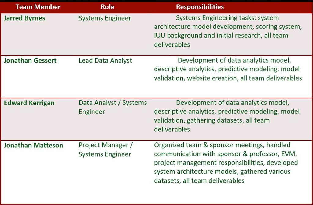
51 Roles and Responsibilities 51

52 Schedule 52
Using satellite technology to monitor illegal, unreported, and unregulated (IUU) fishing
 fishing") Using satellite technology to monitor illegal, unreported, and unregulated (IUU) fishing Mark Richardson The Pew Charitable Trusts Blue Planet Symposium, June 2, 2017 The global threat of IUU fishing Illegal,
Using satellite technology to monitor illegal, unreported, and unregulated (IUU) fishing Mark Richardson The Pew Charitable Trusts Blue Planet Symposium, June 2, 2017 The global threat of IUU fishing Illegal,
Fisheries (Geospatial Position Reporting Devices) Circular 2017
 Circular 2017") Fisheries (Geospatial Position Reporting Devices) Circular 2017 Issuing Authority This circular is issued under regulation 6 of the Fisheries (Geospatial Position Reporting) Regulations 2017 by Martyn
Fisheries (Geospatial Position Reporting Devices) Circular 2017 Issuing Authority This circular is issued under regulation 6 of the Fisheries (Geospatial Position Reporting) Regulations 2017 by Martyn
Satellite Technologies for Fisheries Monitoring, Control and Surveillance (MCS)
") JRC IPSC Maritime Affairs 1 Satellite Technologies for Fisheries Monitoring, Control and Surveillance (MCS) Juan Cicuendez, Marlene Alvarez JRC Info Day Madrid, 2 June 2010 IPSC - Institute for the Protection
JRC IPSC Maritime Affairs 1 Satellite Technologies for Fisheries Monitoring, Control and Surveillance (MCS) Juan Cicuendez, Marlene Alvarez JRC Info Day Madrid, 2 June 2010 IPSC - Institute for the Protection
A Space-Based Solution for Illegal, Unregulated & Unreported Fishing. Emmanouil Detsis, International Space University
 Project Catch A Space-Based Solution for Illegal, Unregulated & Unreported Fishing Emmanouil Detsis, International Space University Project Catch COPUOS Presentation Team Project Oceans International Intercultural
Multi Sensor Data Fusion
 Multi Sensor Data Fusion for improved maritime traffic monitoring in the Canadian Arctic Giulia Battistello*, Martin Ulmke*, Javier Gonzalez*, Camilla Mohrdieck** (*) Fraunhofer FKIE Sensor Data and Information
ESSnet pilot AIS data. Anke Consten, Eleni Bisioti and Olav Grøndal (23 February 2017, Sofia)
") ESSnet pilot AIS data Anke Consten, Eleni Bisioti and Olav Grøndal (23 February 2017, Sofia) Overview 1. Introduction 2. Deliverables ESSnet pilot AIS data 3. Data access and handling 4. Quality of AIS
ESSnet pilot AIS data Anke Consten, Eleni Bisioti and Olav Grøndal (23 February 2017, Sofia) Overview 1. Introduction 2. Deliverables ESSnet pilot AIS data 3. Data access and handling 4. Quality of AIS
The Pitcairn Islands Marine Reserve A global benchmark in marine protection
 A fact sheet from March 2015 The Pitcairn Islands Marine Reserve A global benchmark in marine protection Overview In September 2016, the United Kingdom created a fully protected marine reserve spanning
RECOMMENDATIONS LDAC CONFERENCE ON EXTERNAL DIMENSION OF THE CFP LAS PALMAS DE GRAN CANARIA, September 2015
 RECOMMENDATIONS LDAC CONFERENCE ON EXTERNAL DIMENSION OF THE CFP LAS PALMAS DE GRAN CANARIA, 16-17 September 2015 GENERAL STATEMENTS 1. We recognise the progress made with the latest reforms to the exterior
Marine Monitor (M ) A Low Cost Radar Solution for Monitoring Nearshore Marine Protected Areas
 A Low Cost Radar Solution for Monitoring Nearshore Marine Protected Areas") 2 Marine Monitor (M ) A Low Cost Radar Solution for Monitoring Nearshore Marine Protected Areas 1 Problem The number of Marine Protected Areas (MPAs) are increasing globally making it challenging to effectively
2 Marine Monitor (M ) A Low Cost Radar Solution for Monitoring Nearshore Marine Protected Areas 1 Problem The number of Marine Protected Areas (MPAs) are increasing globally making it challenging to effectively
Enhanced Maritime Traffic Picture for the Canadian Arctic
 Enhanced Maritime Traffic Picture for the Canadian Arctic Giulia Battistello*, Martin Ulmke*, Camilla Mohrdieck** (*) Fraunhofer FKIE - Sensor Data and Information Fusion Department - Wachtberg, Germany
MCS Needs of Developing Countries
 MCS Needs of Developing Countries { Introduction Central Management Increasing fish production and profitability Attracted All manner of investments Easy and unfettered access to fisheries resources and
Satellite services for maritime security
 Satellite services for ITS-T Sophia Antipolis 6 June 2007 Jean-Pierre Cauzac, CLS - Collecte Localisation Satellites 35 Are the seas becoming more dangerous? IMB report 2006 shows improvement: 239 piracy
Transparency in the Western and Central Pacific Tuna Longline Fishery Enhancing verifiability with electronic reporting and monitoring
 A brief from July 2016 Michael Crispino Transparency in the Western and Central Pacific Tuna Longline Fishery Enhancing verifiability with electronic reporting and monitoring Overview Tuna longline fisheries
Global Record. Fishing Vessels, Refrigerated Transport Vessels and Supply Vessels THE
 THE Global Record of Fishing Vessels, Refrigerated Transport Vessels and Supply Vessels Providing a single access point for information on vessels used for fishing and fishing-related activities to combat
Economic and Social Council
 United Nations Economic and Social Council Distr.: General 14 February 2018 Original: English Economic Commission for Europe UNECE Executive Committee Centre for Trade Facilitation and Electronic Business
Fishing for data. The role of private data platforms in addressing illegal, unreported and unregulated fishing and overfishing.
 Briefing note Fishing for data The role of private data platforms in addressing illegal, unreported and unregulated fishing and overfishing Miren Gutierrez, Alfonso Daniels and Guy Jobbins December 2017
To Undertake a Rapid Assessment of Fisheries and Aquaculture Information Management System (FIMS) in Kenya
 in Kenya") Republic of Kenya MINISTRY OF AGRICULTURE, LIVESTOCK & FISHERIES STATE DEPARTMENT OF FISHERIES AND BLUE ECONOMY KENYA MARINE FISHERIES AND SOCIO-ECONOMIC DEVELOPMENT PROJECT (KEMFSED) TERMS OF REFERENCE
Republic of Kenya MINISTRY OF AGRICULTURE, LIVESTOCK & FISHERIES STATE DEPARTMENT OF FISHERIES AND BLUE ECONOMY KENYA MARINE FISHERIES AND SOCIO-ECONOMIC DEVELOPMENT PROJECT (KEMFSED) TERMS OF REFERENCE
Fisheries and Marine Resources (Automatic Identification System) Regulations
 Regulations") Fisheries and Marine Resources (Automatic Identification System) Regulations 2016 GN No. 116 of 2016 Government Gazette of Mauritius No. 47of 28 May 2016 THE FISHERIES AND MARINE RESOURCES ACT Regulations
Fisheries and Marine Resources (Automatic Identification System) Regulations 2016 GN No. 116 of 2016 Government Gazette of Mauritius No. 47of 28 May 2016 THE FISHERIES AND MARINE RESOURCES ACT Regulations
Havforskningsinstituttet
 to conduct Marine Scientific Research Versjon: 1.02 Opprettet: 11.12.2013 Skrevet av: BTC Godkjent av: KRR Gjelder fra: 11.12.2013 Standard Sidenr: 1 av 6 Application for Consent to conduct Marine Scientific
Vessel Traffic Generator. Agent based maritime traffic generator
 Vessel Traffic Generator Agent based maritime traffic generator Motivation Why (I) Need for data sets to develop and validate Maritime Situational Awareness algorithms Problem Real-world data (e.g. AIS
Using AIS to identify and investigate ferry accidents
 Using AIS to identify and investigate ferry accidents David Hewson Antenna Network Manager Genscape Vesseltracker info@genscape.com DE: +49 (0) 97 07 86 10 EU: +31 20 524 4089 Background Vesseltracker
AFRICAN UNION HARMONIZED FISHING VESSEL REGISTER AN INSTRUCTION MANUAL
 AFRICAN UNION HARMONIZED FISHING VESSEL REGISTER AN INSTRUCTION MANUAL Strengthening Regional Fishing Vessel Registers for effective Monitoring, Control and Surveillance Systems in Africa AFRICAN UNION
International Journal of Advance Engineering and Research Development ADVANCED NAVIGATOR AND MONITORING SYSTEM FOR FISHERMAN
 Scientific Journal of Impact Factor(SJIF): 3.134 International Journal of Advance Engineering and Research Development Volume 3,Issue 3, March -2016 e-issn(o): 2348-4470 p-issn(p): 2348-6406 ADVANCED NAVIGATOR
Session 8: Maritime Safety and Security. Raymond Gilpin, Ph.D. Academic Dean. Impact through Insight
 Session 8: Maritime Safety and Security Raymond Gilpin, Ph.D. Academic Dean Impact through Insight Africa s Maritime Environment Abundant natural resources: Significant fishing grounds Growing interest
INTEGRATION SYSTEM OF AUTOMATIC IDENTIFICATION SYSTEM AND RADAR FOR PORT TRAFFIC MANAGEMENT
 Jurnal Mekanikal June 2015, Vol 38, 32-45 INTEGRATION SYSTEM OF AUTOMATIC IDENTIFICATION SYSTEM AND RADAR FOR PORT TRAFFIC MANAGEMENT NurAireenAmran 1,, Jaswar Koto*,1,2, AdiMaimun 1 1 Faculty of Mechanical
Frank Heymann 1.
 Plausibility analysis of navigation related AIS parameter based on time series Frank Heymann 1 1 Deutsches Zentrum für Luft und Raumfahrt ev, Neustrelitz, Germany email: frank.heymann@dlr.de In this paper
RESOLUTION MSC.229(82) (adopted on 5 December 2006) ADOPTION OF A NEW MANDATORY SHIP REPORTING SYSTEM "IN THE GALAPAGOS PARTICULARLY SENSITIVE SEA
 (adopted on 5 December 2006) ADOPTION OF A NEW MANDATORY SHIP REPORTING SYSTEM IN THE GALAPAGOS PARTICULARLY SENSITIVE SEA") MSC 82/24/Add.2 RESOLUTION MSC.229(82) IN THE GALAPAGOS PARTICULARLY SENSITIVE SEA AREA (PSSA) (GALREP) THE MARITIME SAFETY COMMITTEE, RECALLING Article 28(b) of the Convention on the International Maritime
MSC 82/24/Add.2 RESOLUTION MSC.229(82) IN THE GALAPAGOS PARTICULARLY SENSITIVE SEA AREA (PSSA) (GALREP) THE MARITIME SAFETY COMMITTEE, RECALLING Article 28(b) of the Convention on the International Maritime
RESOLUTION MSC.278(85) (adopted on 1 December 2008) ADOPTION OF THE NEW MANDATORY SHIP REPORTING SYSTEM "OFF THE COAST OF PORTUGAL - COPREP"
 (adopted on 1 December 2008) ADOPTION OF THE NEW MANDATORY SHIP REPORTING SYSTEM OFF THE COAST OF PORTUGAL - COPREP") MSC 85/26/Add.1 RESOLUTION MSC.278(85) SYSTEM OFF THE COAST OF PORTUGAL COPREP THE MARITIME SAFETY COMMITTEE, RECALLING Article 28 of the Convention on the International Maritime Organization concerning
MSC 85/26/Add.1 RESOLUTION MSC.278(85) SYSTEM OFF THE COAST OF PORTUGAL COPREP THE MARITIME SAFETY COMMITTEE, RECALLING Article 28 of the Convention on the International Maritime Organization concerning
Demonstrator of a Data Processing Centre (DPC) for satellite-based AIS services
 for satellite-based AIS services") Page 1 Demonstrator of a Data Processing Centre (DPC) for satellite-based AIS services 19/20 April 2012 gfabritius@cls.fr Overview of the presentation Page 2 Introducing CLS Introducing AIS / SAT-AIS Scope
Page 1 Demonstrator of a Data Processing Centre (DPC) for satellite-based AIS services 19/20 April 2012 gfabritius@cls.fr Overview of the presentation Page 2 Introducing CLS Introducing AIS / SAT-AIS Scope
Copyright 2016 Raytheon Company. All rights reserved. Customer Success Is Our Mission is a registered trademark of Raytheon Company.
 Make in India Paradigm : Roadmap for a Future Ready Naval Force Session 9: Coastal Surveillance, Response Systems and Platforms Nik Khanna, President, India April 19, 2016 "RAYTHEON PROPRIETARY DATA THIS
Geocoding DoubleCheck: A Unique Location Accuracy Assessment Tool for Parcel-level Geocoding
 Measuring, Modelling and Mapping our Dynamic Home Planet Geocoding DoubleCheck: A Unique Location Accuracy Assessment Tool for Parcel-level Geocoding Page 1 Geocoding is a process of converting an address
Part 1 Framework for using the FMSP stock assessment tools
 Part 1 Framework for using the FMSP stock assessment tools 1. Introduction 1.1 The new international legal regime Most fisheries books seem to begin with an account of the poor state of the world s fish
AI Fairness 360. Kush R. Varshney
 IBM Research AI AI Fairness 360 Kush R. Varshney krvarshn@us.ibm.com http://krvarshney.github.io @krvarshney http://aif360.mybluemix.net https://github.com/ibm/aif360 https://pypi.org/project/aif360 2018
Argo. 1,000m: drift approx. 9 days. Total cycle time: 10 days. Float transmits data to users via satellite. Descent to depth: 6 hours
 Float transmits data to users via satellite Total cycle time: 10 days Descent to depth: 6 hours 1,000m: drift approx. 9 days Temperature and salinity profiles are recorded during ascent: 6 hours Float
Successfully Managing Fishing Capacity What options are available?
 Successfully Managing Fishing Capacity What options are available? Rebecca Metzner Fishery Analyst Fishing Capacity FAO Fisheries and Aquaculture Department KOBE2 29 June 3 July 2009 Overview Symptoms
ANNUAL OF NAVIGATION 19/2012/part 1
 ANNUAL OF NAVIGATION 19/2012/part 1 PAWEŁ BANYŚ, THORALF NOACK, STEFAN GEWIES German Aerospace Center (DLR), Institute of Communications and Navigation (IKN) ASSESSMENT OF AIS VESSEL POSITION REPORT UNDER
MSc(CompSc) List of courses offered in
 List of courses offered in") Office of the MSc Programme in Computer Science Department of Computer Science The University of Hong Kong Pokfulam Road, Hong Kong. Tel: (+852) 3917 1828 Fax: (+852) 2547 4442 Email: msccs@cs.hku.hk (The
Office of the MSc Programme in Computer Science Department of Computer Science The University of Hong Kong Pokfulam Road, Hong Kong. Tel: (+852) 3917 1828 Fax: (+852) 2547 4442 Email: msccs@cs.hku.hk (The
TERMS OF REFERENCE Development of South -Western Indian Ocean (SWIO) Fisheries Accord for Shared Fish Stocks
 Fisheries Accord for Shared Fish Stocks") 28 th May 2013 TERMS OF REFERENCE Development of South -Western Indian Ocean (SWIO) Fisheries Accord for Shared Fish Stocks 1. Overview The African Union- InterAfrican Bureau for Animal Resources (AU-IBAR)
28 th May 2013 TERMS OF REFERENCE Development of South -Western Indian Ocean (SWIO) Fisheries Accord for Shared Fish Stocks 1. Overview The African Union- InterAfrican Bureau for Animal Resources (AU-IBAR)
Maritime Autonomous Navigation in GPS Limited Environments
 Maritime Autonomous Navigation in GPS Limited Environments 29/06/2017 IIR/University of Portsmouth GPS signal is unreliable Tamper Jam U.S. stealth UAV captured by Iranian government by means of GPS spoofing.
HF-Radar Network Near-Real Time Ocean Surface Current Mapping
 HF-Radar Network Near-Real Time Ocean Surface Current Mapping The HF-Radar Network (HFRNet) acquires surface ocean radial velocities measured by HF-Radar through a distributed network and processes the
By-Product Fish Fishery Assessment Interpretation Document
 By-Product Fish Fishery Assessment Interpretation Document IFFO RS GLOBAL STANDARD FOR RESPONSIBLE SUPPLY OF MARINE INGREDIENTS BY PRODUCT FISHERY MATERIAL Where fish are processed for human consumption,
MINISTRY OF AGRICULTURE, LIVESTOCK & FISHERIES STATE DEPARTMENT OF FISHERIES AND BLUE ECONOMY
 MINISTRY OF AGRICULTURE, LIVESTOCK & FISHERIES STATE DEPARTMENT OF FISHERIES AND BLUE ECONOMY KENYA MARINE FISHERIES AND SOCIO-ECONOMIC DEVELOPMENT PROJECT (KEMFSED) TERMS OF REFERENCE For an Individual
Targeting a Safer World. Public Safety & Security
 Targeting a Safer World Public Safety & Security WORLD S MOST EFFECTIVE AND AFFORDABLE WIDE-AREA SITUATIONAL AWARENESS Accipiter provides the world s most effective and affordable wide-area situational
Limitations of Satellite AIS: Time Machine Wanted!
 Limitations of Satellite AIS: Time Machine Wanted! Eric Meger CEO, Maerospace Corporation eric.meger@!maerospace.com 3 October 2013 Maritime Domain Awareness is one of the most significant national and
REPORT OF THE FOOD AND AGRICULTURE ORGANIZATION CONCERNING UNITED NATIONS GENERAL ASSEMBLY RESOLUTIONS A/RES/57/141 ON OCEANS AND THE LAW OF THE SEA
 REPORT OF THE FOOD AND AGRICULTURE ORGANIZATION CONCERNING UNITED NATIONS GENERAL ASSEMBLY RESOLUTIONS A/RES/57/141 ON OCEANS AND THE LAW OF THE SEA January 2003 In her letter of 16 November 2003 to the
POTENTIAL LINK BETWEEN IUU FISHING AND THE STATUS OF SAFETY-RELATED INTERNATIONAL INSTRUMENTS APPLICABLE TO FISHING VESSELS AND FISHERMEN
 POTENTIAL LINK BETWEEN IUU FISHING AND THE STATUS OF SAFETY-RELATED INTERNATIONAL INSTRUMENTS APPLICABLE TO FISHING VESSELS AND FISHERMEN WORKSHOP ON IUU FISHING ACTIVITIES OECD, Paris (France),19 and
Call for Papers. Special Issue of Journal of Transportation Security. Maritime Security: Current and Future Challenges
 Call for Papers Special Issue of Journal of Transportation Security Maritime Security: Current and Future Challenges Guest Editors: Chief Editor: Dr. Simon Véronneau, PhD, RAND Corporation Assistant Editor:
Using a Data Fusion-based Activity Recognition Framework to Determine Surveillance System Requirements
 Using a Data Fusion-based Activity Recognition Framework to Determine Surveillance System Requirements Willem H. le Roux and Jan J. Nel Council for Scientific and Industrial Research Pretoria, South Africa
Integrating Spaceborne Sensing with Airborne Maritime Surveillance Patrols
 22nd International Congress on Modelling and Simulation, Hobart, Tasmania, Australia, 3 to 8 December 2017 mssanz.org.au/modsim2017 Integrating Spaceborne Sensing with Airborne Maritime Surveillance Patrols
Figure 7: The search and rescue (SAR) area under the responsibility of the ICG
 area under the responsibility of the ICG") 17 The ICG Operations Centre functions as the SPOC for vessels operating inside the EEZ as well as vessels heading for ports in Iceland and for vessels transiting the Icelandic EEZ. In relation to fisheries,
17 The ICG Operations Centre functions as the SPOC for vessels operating inside the EEZ as well as vessels heading for ports in Iceland and for vessels transiting the Icelandic EEZ. In relation to fisheries,
Rutter High Resolution Radar Solutions
 Rutter High Resolution Radar Solutions High Resolution Imagery, Target Detection, and Tracking At the core of our enhanced radar capabilities are proprietary radar processing and imaging technologies.
Workshop for Capacity Building of Developing States for the Port State Measures and Catch Documentation Scheme
 Workshop for Capacity Building of Developing States for the Port State Measures and Catch Documentation Scheme - Preparatory Workshop for the 3 rd Joint Meeting of the Tuna RFMOs (Kobe III) - (19-21 April,
IMO RESOLUTION A.1001(25) Adopted on 29 November 2007 (Agenda item 9)
 Adopted on 29 November 2007 (Agenda item 9)") INTERNATIONAL MARITIME ORGANIZATION E IMO ASSEMBLY 25th session Agenda item 9 A 25/Res.1001 3 January 2008 Original: ENGLISH RESOLUTION A.1001(25) Adopted on 29 November 2007 (Agenda item 9) CRITERIA FOR
INTERNATIONAL MARITIME ORGANIZATION E IMO ASSEMBLY 25th session Agenda item 9 A 25/Res.1001 3 January 2008 Original: ENGLISH RESOLUTION A.1001(25) Adopted on 29 November 2007 (Agenda item 9) CRITERIA FOR
CMRE La Spezia, Italy
 Innovative Interoperable M&S within Extended Maritime Domain for Critical Infrastructure Protection and C-IED CMRE La Spezia, Italy Agostino G. Bruzzone 1,2, Alberto Tremori 1 1 NATO STO CMRE& 2 Genoa
Understanding AIS. The technology, the limitations and how to overcome them with Lloyd s List Intelligence
 Understanding AIS The technology, the limitations and how to overcome them with Lloyd s List Background to AIS The Automatic Identification System (AIS) was originally introduced in order to improve maritime
International Scientific Committee for Tuna and Tuna-like Species In the North Pacific Ocean
 International Scientific Committee for Tuna and Tuna-like Species In the North Pacific Ocean Back grounds Catch Data for stock assessment Status of Stock Conservation Advice 2 Full new stock assessment
SPECIFICITY of MACHINE LEARNING PROJECTS. Borys Pratsiuk, Head of R&D, Ci
 1 SPECIFICITY of MACHINE LEARNING PROJECTS Borys Pratsiuk, Head of R&D, Ci 2 Who am I? Senior Android Team Lead Android Architect Engineer, R&D Lab, Tescom, South Korea Android Developer Ph.D Solidstate
The Trade and Environment Debate & Sustainable Development Goal (SDG) 14
 14") The Trade and Environment Debate & Sustainable Development Goal (SDG) 14 Aik Hoe LIM, Director, Trade and Environment Division, WTO UNCTAD Oceans Forum on Trade-Related Aspects of SDG14 21 March 2017,
The Trade and Environment Debate & Sustainable Development Goal (SDG) 14 Aik Hoe LIM, Director, Trade and Environment Division, WTO UNCTAD Oceans Forum on Trade-Related Aspects of SDG14 21 March 2017,
Recent Developments in NOAA s Real- Time Coastal Observing Systems for Safe and Efficient Maritime Transportation
 Recent Developments in NOAA s Real- Time Coastal Observing Systems for Safe and Efficient Maritime Transportation Rich Edwing, Director NOAA Center for Operational Oceanographic Products and Services CMTS
An Analysis of Low Earth Orbit Launch Capabilities
 An Analysis of Low Earth Orbit Launch Capabilities George Mason University May 11, 2012 Ashwini Narayan James Belt Colin Mullery Ayobami Bamgbade Content Introduction: Background / need / problem statement
Juan GAVIRIA, Sector Leader AFTTR
 Earth Observation in support of the Western Indian Ocean Marine Highway Development and Coastal and Marine Contamination Prevention Project - Oil spill detection & Coral reef monitoring Juan GAVIRIA, Sector
Western Indian Ocean Marine Highway Development and Coastal and Marine Contamination Prevention Project - Oil spill detection & Coral reef monitoring
 Earth Observation in support of the Western Indian Ocean Marine Highway Development and Coastal and Marine Contamination Prevention Project - Oil spill detection & Coral reef monitoring Juan GAVIRIA, Sector
Linemaster Marine Electronics. Sky Technologies MARINE SERVICES AGENTS APAC
 MARINE SERVICES AGENTS APAC Linemaster Marine Electronics Linemaster was founded in 1992. The result of an idea to create a product to aid in the deployment of Longlines. Today the Linemaster Longline
Route Planning & Cable Route Surveys
 Route Planning & Cable Route Surveys Graham Evans Director EGS Survey Group www.egssurvey.com Concept to Reality Key Phases Development of Business Model Definition of Key Project Milestones Project Concept
Simrad SX90 Long range high definition sonar system
 Simrad SX90 Long range high definition sonar system 360 omnidirectional sonar 90 vertical tip mode 20 to 30 KHz operational frequency Narrow beams Selectable beam width Hyperbolic FM Large dynamic range
Integrated Detection and Tracking in Multistatic Sonar
 Stefano Coraluppi Reconnaissance, Surveillance, and Networks Department NATO Undersea Research Centre Viale San Bartolomeo 400 19138 La Spezia ITALY coraluppi@nurc.nato.int ABSTRACT An ongoing research
PRODUCTS AND SERVICES FOR THE MARITIME COMMUNITY. Ed Martin, Chief Customer Affairs Branch Navigation Services Division Monday, 27 October, 2008
 PRODUCTS AND SERVICES FOR THE MARITIME COMMUNITY Ed Martin, Chief Customer Affairs Branch Navigation Services Division Monday, 27 October, 2008 Coral Reef Conservation International Collaboration Marine
Abstract. 1. Introduction
 Title: Satellite surveillance for maritime border monitoring Author: H. Greidanus Number: File: GMOSSBordMon1-2.doc Version: 1-2 Project: GMOSS Date: 25 Aug 2004 Distribution: Abstract Present day remote
FOR MORE INFORMATION ON GMDSS CONTACT:
 FOR MORE INFORMATION ON GMDSS CONTACT: Commanding Officer USCG Navigation Center, MS 7310, 7323 Telegraph Road, Alexandria, VA 20598-7310 Tel:1-703-313-5900 www.navcen.uscg.gov Commandant (CG-652) Spectrum
The Contribution of Marine Economy to the National Economic Development of China
 The Contribution of Marine Economy to the National Economic Development of China Prof. Liu Rongzi China Institute of Marine Affairs, SOA 2009.11.23-27 27 Researches of marine economics contribution & relational
In the name, particularly, of the women from these organizations, and the communities that depend on fishing for their livelihoods,
 Confédération Africaine des Organisations Professionnelles de la Pêche Artisanale African Confederation of Artisanal Fisheries Professional organizations 1 On the occasion of the World Women's Day of the
MARINE PARK ENHANCED APPLICATIONS BASED ON USE OF INTEGRATED GNSS SERVICES
 MARINE PARK ENHANCED APPLICATIONS BASED ON USE OF INTEGRATED GNSS SERVICES Valerio Corini NAIS Srl, Via Andrea Noale 345/A, 00155 Rome, Italy, Tel: +39 06 91139018, Fax: +39.06.91139026, valerio.corini@nais-solutions.it
NOT FOR REPRODUCTION. Affordable, multi-mission radar surveillance networks for marine and port security. by Tim J. Nohara
 by Tim J. Nohara NOT FOR REPRODUCTION Affordable, multi-mission radar surveillance networks for marine and port security Introduction The events of September 11, 2001, have focused the efforts of various
Policy Research Corporation
 Policy Research Corporation SOUND SOLUTIONS BASED ON SCIENTIFIC RESEARCH The role of Maritime Clusters to enhance the strength and development of maritime sectors Country report Poland INTRODUCTION TO
COORDINATING WORKING PARTY ON FISHERY STATISTICS. Intersessional Fishery Subject Group Meeting. Swakopmund, Namibia February 2015
 CWP/IFS/2015/7 COORDINATING WORKING PARTY ON FISHERY STATISTICS Intersessional Fishery Subject Group Meeting Swakopmund, Namibia 25-27 February 2015 CWP - How to improve global data collection Author:
Port Security and Technology - the U.S. Perspective. Michael S. Bruno Stevens Institute of Technology March 14, 2012
 Port Security and Technology - the U.S. Perspective Michael S. Bruno Stevens Institute of Technology March 14, 2012 CSR A Department of Homeland Security National Center of Excellence for Port Security
Local and Low-Cost White Space Detection
 Local and Low-Cost White Space Detection Ahmed Saeed*, Khaled A. Harras, Ellen Zegura*, and Mostafa Ammar* *Georgia Institute of Technology Carnegie Mellon University Qatar White Space Definition A vacant
Consultation on International Ocean Governance
 Consultation on International Ocean Governance 1 Context Oceans are a key source of nutritious food, medicine, minerals and renewable energy. They are also home to a rich, fragile, and largely unknown
Blue growth. Stijn Billiet. DG Maritime Affairs and Fisheries
 Blue growth Stijn Billiet DG Maritime Affairs and Fisheries Overview The EU's blue economy is already significant 550 billion EUR Gross Value Added (4% of the EU economy), 5 million jobs EU is global market
Integration System of Automatic Identification System (AIS) and Radar for Port Traffic Management
 and Radar for Port Traffic Management") Integration System of Automatic Identification System (AIS) and Radar for Port Traffic Management Nur Aireen Amran, a, Jaswar Koto, a* and Adi Maimun, a a) Department of Aeronautics, Automotive and Ocean
Integration System of Automatic Identification System (AIS) and Radar for Port Traffic Management Nur Aireen Amran, a, Jaswar Koto, a* and Adi Maimun, a a) Department of Aeronautics, Automotive and Ocean
DEFENSE ACQUISITION UNIVERSITY EMPLOYEE SELF-ASSESSMENT. Outcomes and Enablers
 Outcomes and Enablers 1 From an engineering leadership perspective, the student will describe elements of DoD systems engineering policy and process across the Defense acquisition life-cycle in accordance
Emergency Marine Communications
 Emergency Marine Communications Presented by: Steve Chamberlin Content:Chuck Hawley Safety at Sea Seminar US Sailing Goals of Emergency Communications To alert rescue services to your situation To get
Cost Effective Control of your Coastal Waters
 Cost Effective Control of your Coastal Waters Olov Fäst SSC Airborne Systems 2013-07-03 SSC: A comprehensive space industry Founded in 1972 ~650 employees (2012) ~100 M turnover (2012) Since the start
National Maritime Center
 National Maritime Center Providing Credentials to Mariners (Sample Examination) Page 1 of 6 Choose the best answer to the following Multiple Choice Questions. 1. The following questions are based on Chart
Security Systems Division
 Security Systems Division SIVE A PIONEER MARITIME BORDER SURVEILLANCE SYSTEM. WHAT IS BEYOND? Pros and cons of the SIVE system today in the new coastal and deepwater border scenario and our vision of a
VMS Vessel Monitoring System
 VMS Vessel Monitoring System Satellite Vessel Tracking and Monitoring Solution BlueTraker VMS Offers Low Operating Costs Embedded Geozones True Global Coverage Low Power Design Data Encryption Security
INTRODUCTION 1.1 Overexploitation in world fisheries 1.2 The International Plan of Action for the Management of Fishing Capacity (IPOA-Capacity)
") 1 1. INTRODUCTION 1.1 Overexploitation in world fisheries Fishing is an economic activity. Fishing effort is targeted towards species that have a value to consumers (represented by the price consumers
1 1. INTRODUCTION 1.1 Overexploitation in world fisheries Fishing is an economic activity. Fishing effort is targeted towards species that have a value to consumers (represented by the price consumers
Gridiron-Gurus Final Report
 Gridiron-Gurus Final Report Kyle Tanemura, Ryan McKinney, Erica Dorn, Michael Li Senior Project Dr. Alex Dekhtyar June, 2017 Contents 1 Introduction 1 2 Player Performance Prediction 1 2.1 Components of
Assembly. International Seabed Authority ISBA/22/A/INF/5
 International Seabed Authority ISBA/22/A/INF/5 Assembly Distr.: General 13 June 2016 Original: English Twenty-second session Kingston, Jamaica 11-22 July 2016 Request for observer status in accordance
Development of Microsatellite to Detect Illegal Fishing MS-SAT
 Development of Microsatellite to Detect Illegal Fishing MS-SAT Ernest S. C. P. Bintang A.S.W.A.M. Department of Aerospace Engineering Faculty of Mechanical and Aerospace Engineering Institut Teknologi
Graham Stickler Esri Ocean GIS Forum, Redlands, CA, 5-7 November 2013
 Graham Stickler Esri Ocean GIS Forum, Redlands, CA, 5-7 November 2013 Imagine.. A world with no horizons Coastal Coverage Space View Satellite Constellation 6 satellite polar orbiting + 1 equatorial constellation
«INTRARADAR» Port of Corfu
 «INTRARADAR» Port of Corfu INTERREG IIIA Greece-Italy IMPETUS was the contractor of the Prefecture of Corfu for the INTRARADAR project. The project focused on the provision, installation of hardware/software
AAPSilver System Performance Validation
 Report No. CG-D-04-13 AAPSilver System Performance Validation Distribution Statement A: Approved for public release; distribution is unlimited. 1 N O T I C E This document is disseminated under the sponsorship
DOWNLOAD PDF OCEANS GOVERNANCE AND MARITIME STRATEGY
 Chapter 1 : David Wilson, Dick Sherwood's Oceans Governance and Maritime Strategy PDF - AAPC E-boo International ocean governance is about managing and using the world's oceans and their resources in ways
Plausibility analysis of navigation related AIS parameter based on time series
 Plausibility analysis of navigation related AIS parameter based on time series Frank Heymann, Thoralf Noack, Paweł Banyś Deutsches Zentrum für Luft und Raumfahrt ev, Neustrelitz, Germany email: frank.heymann@dlr.de
BALTIC SEA SEAL AND CORMORANT TNC-PROJECT
 FLAGs Trans-national Cooperation Project Plan BALTIC SEA SEAL AND CORMORANT TNC-PROJECT Saving the Endangered Baltic Sea Coastal Fisherman finding sustainable solutions to deal with growing seal and cormorant
Annex 11 to Working Party 5B Chairman s Report WORKING DOCUMENT TOWARDS A PRELIMINARY DRAFT NEW REPORT ITU-R M.[SNAP]
![Annex 11 to Working Party 5B Chairman s Report WORKING DOCUMENT TOWARDS A PRELIMINARY DRAFT NEW REPORT ITU-R M.[SNAP]](/thumbs/92/108810182.jpg "Annex 11 to Working Party 5B Chairman s Report WORKING DOCUMENT TOWARDS A PRELIMINARY DRAFT NEW REPORT ITU-R M.[SNAP]") Radiocommunication Study Groups Source: Document 5B/TEMP/287 Annex 11 to Document 5B/617-E 29 November 2010 English only Annex 11 to Working Party 5B Chairman s Report WORKING DOCUMENT TOWARDS A PRELIMINARY
Radiocommunication Study Groups Source: Document 5B/TEMP/287 Annex 11 to Document 5B/617-E 29 November 2010 English only Annex 11 to Working Party 5B Chairman s Report WORKING DOCUMENT TOWARDS A PRELIMINARY
Workshop on Intelligent System and Applications (ISA 17)
") Telemetry Mining for Space System Sara Abdelghafar Ahmed PhD student, Al-Azhar University Member of SRGE Workshop on Intelligent System and Applications (ISA 17) 13 May 2017 Workshop on Intelligent System
Telemetry Mining for Space System Sara Abdelghafar Ahmed PhD student, Al-Azhar University Member of SRGE Workshop on Intelligent System and Applications (ISA 17) 13 May 2017 Workshop on Intelligent System
Claire Jolly Head, Innovation Policies for Space and Oceans Unit, OECD. Our Ocean Wealth Summit: Investing in Marine Ireland
 Claire Jolly Head, Innovation Policies for Space and Oceans Unit, OECD Our Ocean Wealth Summit: Investing in Marine Ireland INVESTING IN MARINE IRELAND Some OECD perspectives on The Ocean Economy Claire
Advice June, revised September 2010
 .. Advice June, revised September ECOREGION STOCK Celtic Sea and West of Scotland Sole in Division VIIa (Irish Sea) Advice summary for Management Objective (s) Landings in Transition to an MSY approach