Vessel Traffic Generator. Agent based maritime traffic generator
|
|
|
- William Shields
- 5 years ago
- Views:
Transcription


1 Vessel Traffic Generator Agent based maritime traffic generator
 has limitations Unknown intent Not all vessel information available (owner, crew, etc.")
2 Motivation Why (I) Need for data sets to develop and validate Maritime Situational Awareness algorithms Problem Real-world data (e.g. AIS recordings) has limitations Unknown intent Not all vessel information available (owner, crew, etc.) Not all vessels can be recorded (vessels without AIS devices) Real-world data is a fixed scenario Solution Vessel Traffic Generator (VTG)
3 Motivation Why (II) Need for efficient generation of maritime scenarios for gaming and experimentation Problem Manually creating complex scenarios is a time consuming task No time available to define realistic background traffic Solution Vessel Traffic Generator (VTG)
4 Related work 1. Pattern Of Life capabilities of commercial tools (DI-Guy AI, VR- Forces B-Have, ) Simple background traffic, additional entity information (alibi, intent,..) not available 2. Generating a maritime traffic scenario based on captured AIS data (FFI and others) 3. Agent-based Simulation of Maritime Transit (Czech Technical University) 4. Simulating Marine Asymmetric Scenarios for testing different C2 Maturity Levels (University of Genoa)
5 VTG approach The Vessel Traffic Generator Approach
 per vessel type (ferry, fishing boat) Authoring can also be done using a KML editor such as Google")
6 VTG scenario definition Sketch-based scenario creation Defining harbours, sealanes, ferry routes, fishing area s using lines and polygons Adjust desired densities (min/max/avg) per vessel type (ferry, fishing boat) Authoring can also be done using a KML editor such as Google Earth
7 Vessel generation Vessels are generated within the AOI based on sketched scenario AOI is seeded initially at scenario at specific time International traffic is spawned regularly at AOI edges to maintain desired densities Alibi generator Each ship has an alibi (origin, destination, ) Alibis are generated only when needed Provide statistically accurate context while simulating only area of interest Extensive dynamic attribute set for each generated vessel State (attacking, fishing, loitering,..) Crew (names) and vessel properties (dimensions, maintenance condition) Sensor signature Intent (smuggling, pirating, illegal fishery)
")
 Resources: cargo, AIS,.")
8 Vessel behaviour definition Behaviour definition using Daily Motion Patterns (DMP) DMP specifies: When What (plan) How (fishing pattern) Resources: cargo, AIS,.. Example fishing ship DMP
 Ship static & voyage related data (message 5) Alpha report generator Reporting presence to NATO Maritime Command when entering High Risk")
9 Simulated vessel reporting Automatic Identification System (AIS) generator Automatic reporting for AIS capable ships Position report (messages 1, 2 & 3) Ship static & voyage related data (message 5) Alpha report generator Reporting presence to NATO Maritime Command when entering High Risk Area
10 VTG implementation Framework: MAK VR-Forces HLA 1516e, Time Managed Real-Time & Non Real-Time mode VTG plugin for VR-Forces Logic for generating ships based on scenario and DMP definitions GUI tools for defining scenarios and inspecting vessel attributes Daily Motion Pattern State machine based User-editable definitions file (XML)
11 VTG implementation Each vessel is generated based on a template A template defines all ranges of attributes for a specific vessel type Vessel attributes defined using expressions Speed {slow=kts(3.0), typical=kts(rndrange(5.0, 15.0))} Flag {IN=40,JO=5,OM=15,SA=25,RU=3,YE=7,CN=5} Report generator (AIS & Alpha) HLA (RPR-FOM + AIS BOM), Time Managed
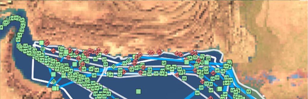
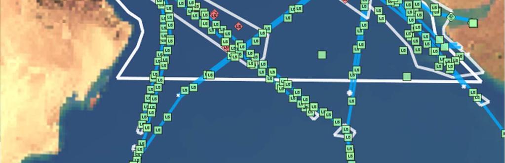
12 Results


13 all traffic pirates only before boarding Example dataset (5 days)
14 Results Vessel Traffic Generator Generates ground truth data State. Observer model provides perceived world Visual Sensors (Radar,..) AIS reports Alpha report Ground truth data Enables validation of Maritime SA Modules
15 Results Demo: movie clip
16 Future work 1. Improve ship dynamics and trajectories 2. Define vessel behaviour inside harbours 3. Validate Daily Motion Patterns with SMEs 4. Use more real-world data (sealanes, harbours, ferry time tables,..)
Fisheries and Marine Resources (Automatic Identification System) Regulations
 Regulations") Fisheries and Marine Resources (Automatic Identification System) Regulations 2016 GN No. 116 of 2016 Government Gazette of Mauritius No. 47of 28 May 2016 THE FISHERIES AND MARINE RESOURCES ACT Regulations
Fisheries and Marine Resources (Automatic Identification System) Regulations 2016 GN No. 116 of 2016 Government Gazette of Mauritius No. 47of 28 May 2016 THE FISHERIES AND MARINE RESOURCES ACT Regulations
Satellite Technologies for Fisheries Monitoring, Control and Surveillance (MCS)
") JRC IPSC Maritime Affairs 1 Satellite Technologies for Fisheries Monitoring, Control and Surveillance (MCS) Juan Cicuendez, Marlene Alvarez JRC Info Day Madrid, 2 June 2010 IPSC - Institute for the Protection
JRC IPSC Maritime Affairs 1 Satellite Technologies for Fisheries Monitoring, Control and Surveillance (MCS) Juan Cicuendez, Marlene Alvarez JRC Info Day Madrid, 2 June 2010 IPSC - Institute for the Protection
The Nordic Institute of Navigation (NNF)
") The Nordic Institute of Navigation (NNF) www.nornav.org non-profit, independent and a non-political organization for professionals working within the field of navigation. The focus of NNF is on all aspects
The Nordic Institute of Navigation (NNF) www.nornav.org non-profit, independent and a non-political organization for professionals working within the field of navigation. The focus of NNF is on all aspects
Frank Heymann 1.
 Plausibility analysis of navigation related AIS parameter based on time series Frank Heymann 1 1 Deutsches Zentrum für Luft und Raumfahrt ev, Neustrelitz, Germany email: frank.heymann@dlr.de In this paper
Satellite services for maritime security
 Satellite services for ITS-T Sophia Antipolis 6 June 2007 Jean-Pierre Cauzac, CLS - Collecte Localisation Satellites 35 Are the seas becoming more dangerous? IMB report 2006 shows improvement: 239 piracy
The LVCx Framework. The LVCx Framework An Advanced Framework for Live, Virtual and Constructive Experimentation
 An Advanced Framework for Live, Virtual and Constructive Experimentation An Advanced Framework for Live, Virtual and Constructive Experimentation The CSIR has a proud track record spanning more than ten
ESSnet pilot AIS data. Anke Consten, Eleni Bisioti and Olav Grøndal (23 February 2017, Sofia)
") ESSnet pilot AIS data Anke Consten, Eleni Bisioti and Olav Grøndal (23 February 2017, Sofia) Overview 1. Introduction 2. Deliverables ESSnet pilot AIS data 3. Data access and handling 4. Quality of AIS
ESSnet pilot AIS data Anke Consten, Eleni Bisioti and Olav Grøndal (23 February 2017, Sofia) Overview 1. Introduction 2. Deliverables ESSnet pilot AIS data 3. Data access and handling 4. Quality of AIS
Demonstrator of a Data Processing Centre (DPC) for satellite-based AIS services
 for satellite-based AIS services") Page 1 Demonstrator of a Data Processing Centre (DPC) for satellite-based AIS services 19/20 April 2012 gfabritius@cls.fr Overview of the presentation Page 2 Introducing CLS Introducing AIS / SAT-AIS Scope
Page 1 Demonstrator of a Data Processing Centre (DPC) for satellite-based AIS services 19/20 April 2012 gfabritius@cls.fr Overview of the presentation Page 2 Introducing CLS Introducing AIS / SAT-AIS Scope
CHAPTER 1 INTRODUCTION
 1 CHAPTER 1 INTRODUCTION In maritime surveillance, radar echoes which clutter the radar and challenge small target detection. Clutter is unwanted echoes that can make target detection of wanted targets
Enhanced Maritime Traffic Picture for the Canadian Arctic
 Enhanced Maritime Traffic Picture for the Canadian Arctic Giulia Battistello*, Martin Ulmke*, Camilla Mohrdieck** (*) Fraunhofer FKIE - Sensor Data and Information Fusion Department - Wachtberg, Germany
E-NAVIGATION AND BEYOND
 E-NAVIGATION AND BEYOND The Work of IALA e-navigation Committee and Future CDR. Hideki NOGUCHI, Chair, IALA ENAV Committee e-navigation (ENAV) Committee Established in 2010 by merging R-NAV and AIS Committee
Plausibility analysis of navigation related AIS parameter based on time series
 Plausibility analysis of navigation related AIS parameter based on time series Frank Heymann, Thoralf Noack, Paweł Banyś Deutsches Zentrum für Luft und Raumfahrt ev, Neustrelitz, Germany email: frank.heymann@dlr.de
CMRE La Spezia, Italy
 Innovative Interoperable M&S within Extended Maritime Domain for Critical Infrastructure Protection and C-IED CMRE La Spezia, Italy Agostino G. Bruzzone 1,2, Alberto Tremori 1 1 NATO STO CMRE& 2 Genoa
RESOLUTION MSC.278(85) (adopted on 1 December 2008) ADOPTION OF THE NEW MANDATORY SHIP REPORTING SYSTEM "OFF THE COAST OF PORTUGAL - COPREP"
 (adopted on 1 December 2008) ADOPTION OF THE NEW MANDATORY SHIP REPORTING SYSTEM OFF THE COAST OF PORTUGAL - COPREP") MSC 85/26/Add.1 RESOLUTION MSC.278(85) SYSTEM OFF THE COAST OF PORTUGAL COPREP THE MARITIME SAFETY COMMITTEE, RECALLING Article 28 of the Convention on the International Maritime Organization concerning
MSC 85/26/Add.1 RESOLUTION MSC.278(85) SYSTEM OFF THE COAST OF PORTUGAL COPREP THE MARITIME SAFETY COMMITTEE, RECALLING Article 28 of the Convention on the International Maritime Organization concerning
Integrating Spaceborne Sensing with Airborne Maritime Surveillance Patrols
 22nd International Congress on Modelling and Simulation, Hobart, Tasmania, Australia, 3 to 8 December 2017 mssanz.org.au/modsim2017 Integrating Spaceborne Sensing with Airborne Maritime Surveillance Patrols
«INTRARADAR» Port of Corfu
 «INTRARADAR» Port of Corfu INTERREG IIIA Greece-Italy IMPETUS was the contractor of the Prefecture of Corfu for the INTRARADAR project. The project focused on the provision, installation of hardware/software
Innovative Maritime Surveillance Capabilities. Pre-operational Services for Highly. Development of. Maria Angelucci, e-geos
 Development of Pre-operational Services for Highly Innovative Maritime Surveillance Capabilities ASI Workshop - 7 th Framework Program Rome, June 27 th, 2012 Maria Angelucci, e-geos 1 Figures Start date:
GUIDELINES ON ANNUAL TESTING OF THE AUTOMATIC IDENTIFICATION SYSTEM (AIS)
") INTERNATIONAL MARITIME ORGANIZATION 4 ALBERT EMBANKMENT LONDON SE1 7SR Telephone: 020 7735 7611 Fax: 020 7587 3210 IMO E Ref. T1/10 MSC.1/Circ.1252 22 October 2007 GUIDELINES ON ANNUAL TESTING OF THE AUTOMATIC
INTERNATIONAL MARITIME ORGANIZATION 4 ALBERT EMBANKMENT LONDON SE1 7SR Telephone: 020 7735 7611 Fax: 020 7587 3210 IMO E Ref. T1/10 MSC.1/Circ.1252 22 October 2007 GUIDELINES ON ANNUAL TESTING OF THE AUTOMATIC
Space Based Vessel Detection - Combining Earth Observation and AIS for Maritime surveillance TEXAS V and C-Σ III
 Space Based Vessel Detection - Combining Earth Observation and AIS for Maritime surveillance TEXAS V and C-Σ III Tony Bauna Director, Product and Service Development, Kongsberg Satellite Services, Tromsø,
THE ELECTRONIC CHART DISPLAY AND INFORMATION SYSTEM (ECDIS) IN CHINA
 IN CHINA") International Hydrographic 'Review, Monaco, LXIX(2), September 1992 THE ELECTRONIC CHART DISPLAY AND INFORMATION SYSTEM (ECDIS) IN CHINA by The Research Group on ECDIS 1 Abstract This paper presents a
International Hydrographic 'Review, Monaco, LXIX(2), September 1992 THE ELECTRONIC CHART DISPLAY AND INFORMATION SYSTEM (ECDIS) IN CHINA by The Research Group on ECDIS 1 Abstract This paper presents a
Satellite data for Maritime Operations. Andreas Hay Kaljord Project Manager Energy, Environment & Security
 Satellite data for Maritime Operations Andreas Hay Kaljord Project Manager Energy, Environment & Security Kongsberg Satellite Services (KSAT) World leading provider within our business area Supports 85
Simulation of Passenger Evacuation using a NAPA Model
 Simulation of Passenger Evacuation using a NAPA Model J. Ala-Peijari, P. Berseneff (STX Europe) U. Langbecker (GL), A. Metsä (NAPA) Page 1 Outline Introduction Model Creation Evacuation Simulation Sample
Abstract. 1. Introduction
 Title: Satellite surveillance for maritime border monitoring Author: H. Greidanus Number: File: GMOSSBordMon1-2.doc Version: 1-2 Project: GMOSS Date: 25 Aug 2004 Distribution: Abstract Present day remote
COMMISSION IMPLEMENTING REGULATION (EU)
") 28.7.2012 Official Journal of the European Union L 202/5 REGULATIONS COMMISSION IMPLEMENTING REGULATION (EU) No 689/2012 of 27 July 2012 amending Regulation (EC) No 415/2007 concerning the technical specifications
28.7.2012 Official Journal of the European Union L 202/5 REGULATIONS COMMISSION IMPLEMENTING REGULATION (EU) No 689/2012 of 27 July 2012 amending Regulation (EC) No 415/2007 concerning the technical specifications
Virtual Prototyping in Ship Design
 Virtual Prototyping in Ship Design Marco Raffa, Roberto Costa Fincantieri - Cantieri Navali Italiani S.p.A. Via Cipro, 11-16129 Genova, Italy email: marco.raffa@fincantieri.it, roberto.costa@fincantieri.it
RF Monitoring Service Profile Based on AIS Binary Message
 , pp.55-59 http://dx.doi.org/10.14257/astl.2015.108.13 RF Monitoring Service Profile Based on AIS Binary Message Soyoung Hwang Catholic University of Pusan, 609-757 Busan, South Korea soyoung@cup.ac.kr
TECHNOLOGY DEVELOPMENT AREAS IN AAWA
 TECHNOLOGY DEVELOPMENT AREAS IN AAWA Technologies for realizing remote and autonomous ships exist. The task is to find the optimum way to combine them reliably and cost effecticely. Ship state definition
Crowd-steering behaviors Using the Fame Crowd Simulation API to manage crowds Exploring ANT-Op to create more goal-directed crowds
 In this chapter, you will learn how to build large crowds into your game. Instead of having the crowd members wander freely, like we did in the previous chapter, we will control the crowds better by giving
A Surveillance System of a Military Harbour Using an Automatic Identification System
 A Surveillance System of a Military Harbour Using an Automatic Identification System Leon Rothkrantz Krispijn Scholte Abstract: The goal of our research is the design and implementation of an automated
8 Anh Duong is head of our borders and maritime security. 9 division. She has years of experience with the U.S.
 8 Anh Duong is head of our borders and maritime security 9 division. She has years of experience with the U.S. 10 Navy. And I think we saw again from the Defense 11 Minister's movie the importance of maritime
Juan GAVIRIA, Sector Leader AFTTR
 Earth Observation in support of the Western Indian Ocean Marine Highway Development and Coastal and Marine Contamination Prevention Project - Oil spill detection & Coral reef monitoring Juan GAVIRIA, Sector
Western Indian Ocean Marine Highway Development and Coastal and Marine Contamination Prevention Project - Oil spill detection & Coral reef monitoring
 Earth Observation in support of the Western Indian Ocean Marine Highway Development and Coastal and Marine Contamination Prevention Project - Oil spill detection & Coral reef monitoring Juan GAVIRIA, Sector
Port Security and Technology - the U.S. Perspective. Michael S. Bruno Stevens Institute of Technology March 14, 2012
 Port Security and Technology - the U.S. Perspective Michael S. Bruno Stevens Institute of Technology March 14, 2012 CSR A Department of Homeland Security National Center of Excellence for Port Security
Multi Sensor Data Fusion
 Multi Sensor Data Fusion for improved maritime traffic monitoring in the Canadian Arctic Giulia Battistello*, Martin Ulmke*, Javier Gonzalez*, Camilla Mohrdieck** (*) Fraunhofer FKIE Sensor Data and Information
PMAR Piracy, Maritime Awareness & Risks
 PMAR Piracy, Maritime Awareness & Risks Maritime Situational Awareness for Counter-Piracy European Commission Joint Research Centre 13 June 2012 GeoMaritime, London 1 MSA for counter-piracy study Key elements
Automatic identification system VHF data link loading
 Report ITU-R M.2287-0 (12/2013) Automatic identification system VHF data link loading M Series Mobile, radiodetermination, amateur and related satellite services ii Rep. ITU-R M.2287-0 Foreword The role
Using AIS to identify and investigate ferry accidents
 Using AIS to identify and investigate ferry accidents David Hewson Antenna Network Manager Genscape Vesseltracker info@genscape.com DE: +49 (0) 97 07 86 10 EU: +31 20 524 4089 Background Vesseltracker
Radio Log Book. for Canadian Flag Vessels. 1 Master s Signature. Transports Canada. Transport Canada TP 13926E MARINE SAFETY
 Transport Canada MARINE SAFETY Transports Canada TP 13926E Radio Log Book for Canadian Flag Vessels Also for use on GMDSS exempted vessels Date Commenced Date Completed 1 Instructional Guide for Keeping
A guideline for establishing feature and symbol standard management system for national HOs
 A guideline for establishing feature and symbol standard management system for national HOs Joint 26th TSMAD and 5th DIPWG Meeting Silver Spring, Maryland, USA(10-14 June 2013) Republic of Korea (ROK)
AGENT PLATFORM FOR ROBOT CONTROL IN REAL-TIME DYNAMIC ENVIRONMENTS. Nuno Sousa Eugénio Oliveira
 AGENT PLATFORM FOR ROBOT CONTROL IN REAL-TIME DYNAMIC ENVIRONMENTS Nuno Sousa Eugénio Oliveira Faculdade de Egenharia da Universidade do Porto, Portugal Abstract: This paper describes a platform that enables
GPS Jamming and its impact on maritime navigation
 GPS Jamming and its impact on maritime navigation Dr Alan Grant Research and Development - Special Interest Group 10 th May 2010 Use of GPS in the maritime sector GPS has become the normal means for maritime
ORBCOMM Machine-To-Machine (M2M)
") ORBCOMM Machine-To-Machine (M2M) Texas V & C-Sigma November 2012 Global M2M Connecting the World s Assets Machine-To-Machine (M2M) Applications Global M2M Wireless Network for Narrowband Data Applications
ORBCOMM Machine-To-Machine (M2M) Texas V & C-Sigma November 2012 Global M2M Connecting the World s Assets Machine-To-Machine (M2M) Applications Global M2M Wireless Network for Narrowband Data Applications
JOURNAL OF MARITIME RESEARCH. The Architecture of Data Transmission in Inland Navigation
 JOURNAL OF MARITIME RESEARCH Vol XI. No. II (2014) pp 3 7 ISSN: 1697-4040, www.jmr.unican.es The Architecture of Data Transmission in Inland Navigation A. Lisaj 1,2, and P. Majzner 3 ARTICLE INFO Article
Paper for Consideration by S-100WG3. Report on S-100 Sea trial of KHOA
 S-100WG3-8.1 Paper for Consideration by S-100WG3 Report on S-100 Sea trial of KHOA Submitted by: Executive Summary: Related Documents: Related Projects: Republic of Korea (KHOA) This paper reports the
An Experimentation Framework to Support UMV Design and Development
 An Experimentation Framework to Support UMV Design and Development Dr Roger Neill, Dr Francis Valentinis* and Dr John Wharington Maritime Platforms Division, DSTO *Swinburne University of Technology June
Optimizing Group Transit in the Gulf of Aden
 POSTER 2011, PRAGUE MAY 12 1 Optimizing Group Transit in the Gulf of Aden Ondřej Hrstka 1, Ondřej Vaněk 1 1 Dept. of Cybernetics, FEE Czech Technical University, Technická 2, 166 27 Praha, Czech Republic
RADAR SATELLITES AND MARITIME DOMAIN AWARENESS
 RADAR SATELLITES AND MARITIME DOMAIN AWARENESS J.K.E. Tunaley Corporation, 114 Margaret Anne Drive, Ottawa, Ontario K0A 1L0 (613) 839-7943 Report Documentation Page Form Approved OMB No. 0704-0188 Public
L AGENCE NATIONALE DES FREQUENCES (ANFR) From Titanic to satellite from Morse to digital Entry in a new era for the maritime community
 From Titanic to satellite from Morse to digital Entry in a new era for the maritime community") L AGENCE NATIONALE DES FREQUENCES (ANFR) From Titanic to satellite from Morse to digital Entry in a new era for the maritime community ITU regional seminar 6-8 June 2018 St-Petersburg, Russian Federation
L AGENCE NATIONALE DES FREQUENCES (ANFR) From Titanic to satellite from Morse to digital Entry in a new era for the maritime community ITU regional seminar 6-8 June 2018 St-Petersburg, Russian Federation
VHF Data Exchange System (VDES)
") VHF Data Exchange System (VDES) ETSI Workshop Future Evolution of Marine Communication 7-8 November 2017 Malcolm Lyman Marketing Manager CML Microcircuits UK With acknowledgments to the members of IALA
VHF Data Exchange System (VDES) ETSI Workshop Future Evolution of Marine Communication 7-8 November 2017 Malcolm Lyman Marketing Manager CML Microcircuits UK With acknowledgments to the members of IALA
GUIDANCE FOR THE PRESENTATION AND DISPLAY OF AIS APPLICATION-SPECIFIC MESSAGES INFORMATION
 E 4 ALBERT EMBANKMENT LONDON SE1 7SR Telephone: +44 (0)20 7735 7611 Fax: +44 (0)20 7587 3210 Ref. T2-OSS/2.7.1 SN.1/Circ.290 2 June 2010 GUIDANCE FOR THE PRESENTATION AND DISPLAY OF AIS APPLICATION-SPECIFIC
Vessel Traffic management Systems (VTS)
") Vessel Traffic management Systems (VTS) Stefano Russo DIETI, Università degli Studi di Napoli Federico II www.dessert.unina.it stefano.russo@unina.it PRIN Project GAUSS, Kick off meeting - Università di
Vessel Traffic management Systems (VTS) Stefano Russo DIETI, Università degli Studi di Napoli Federico II www.dessert.unina.it stefano.russo@unina.it PRIN Project GAUSS, Kick off meeting - Università di
How Automatic Identification System (AIS) Is Being Used to Improve Navigation Safety Lock Operations Management Application Michael Winkler
 Is Being Used to Improve Navigation Safety Lock Operations Management Application Michael Winkler") How Automatic Identification System (AIS) Is Being Used to Improve Navigation Safety Lock Operations Management Application Michael Winkler June 2016 LOMA system overview USCG AIS data capabilities: AIS
How Automatic Identification System (AIS) Is Being Used to Improve Navigation Safety Lock Operations Management Application Michael Winkler June 2016 LOMA system overview USCG AIS data capabilities: AIS
vstasker 6 A COMPLETE MULTI-PURPOSE SOFTWARE TO SPEED UP YOUR SIMULATION PROJECT, FROM DESIGN TIME TO DEPLOYMENT REAL-TIME SIMULATION TOOLKIT FEATURES
 REAL-TIME SIMULATION TOOLKIT A COMPLETE MULTI-PURPOSE SOFTWARE TO SPEED UP YOUR SIMULATION PROJECT, FROM DESIGN TIME TO DEPLOYMENT Diagram based Draw your logic using sequential function charts and let
Policy Research Corporation
 Policy Research Corporation SOUND SOLUTIONS BASED ON SCIENTIFIC RESEARCH The role of Maritime Clusters to enhance the strength and development of maritime sectors Country report Germany INTRODUCTION TO
INTEGRATION SYSTEM OF AUTOMATIC IDENTIFICATION SYSTEM AND RADAR FOR PORT TRAFFIC MANAGEMENT
 Jurnal Mekanikal June 2015, Vol 38, 32-45 INTEGRATION SYSTEM OF AUTOMATIC IDENTIFICATION SYSTEM AND RADAR FOR PORT TRAFFIC MANAGEMENT NurAireenAmran 1,, Jaswar Koto*,1,2, AdiMaimun 1 1 Faculty of Mechanical
KONGSBERG. WORLD CLASS through people, technology and dedication WORLD CLASS through people, technology and dedication
 WORLD CLASS through people, technology and dedication WORLD CLASS through people, technology and dedication Skipsdeteksjon fra radarsatellitter SkipSat Richard Hallr Kongsberg Satellite Services AS (KSAT)
Strategic and operational risk management for wintertime maritime transportation system
 Strategic and operational risk management for wintertime maritime transportation system 1. Description of the project s goals and results Final summary BONUS STORMWINDS has the overall objective to enhance
Maritime Autonomous Navigation in GPS Limited Environments
 Maritime Autonomous Navigation in GPS Limited Environments 29/06/2017 IIR/University of Portsmouth GPS signal is unreliable Tamper Jam U.S. stealth UAV captured by Iranian government by means of GPS spoofing.
A Space-Based Solution for Illegal, Unregulated & Unreported Fishing. Emmanouil Detsis, International Space University
 Project Catch A Space-Based Solution for Illegal, Unregulated & Unreported Fishing Emmanouil Detsis, International Space University Project Catch COPUOS Presentation Team Project Oceans International Intercultural
Co-ReSyF RA lecture: Vessel detection and oil spill detection
 This project has received funding from the European Union s Horizon 2020 Research and Innovation Programme under grant agreement no 687289 Co-ReSyF RA lecture: Vessel detection and oil spill detection
Comparison of Two Alternative Movement Algorithms for Agent Based Distillations
 Comparison of Two Alternative Movement Algorithms for Agent Based Distillations Dion Grieger Land Operations Division Defence Science and Technology Organisation ABSTRACT This paper examines two movement
Integration of AIS functionalities
 Integration of AIS functionalities by John O. Klepsvik FARGIS 05 March 01, 2005 WORLD CLASS through people, technology and dedication WORLD CLASS through people, technology and dedication KONGSBERG March
السلطة البحرية االردنية Jordan Maritime Authority
 السلطة البحرية االردنية السلطة البحرية االردنية Humans have always been interested in where things are السلطة البحرية االردنية One of the basic questions have always been where I am? which leads to where
Traffic Management for Smart Cities TNK115 SMART CITIES
 Traffic Management for Smart Cities TNK115 SMART CITIES DAVID GUNDLEGÅRD DIVISION OF COMMUNICATION AND TRANSPORT SYSTEMS Outline Introduction Traffic sensors Traffic models Frameworks Information VS Control
ESA IAP Blue Belt demonstration project:
 Page 1 ESA IAP Blue Belt demonstration project: supporting the European Maritime Safety Agency (EMSA) Blue Belt Project, by providing a service based on satellite based AIS data complementing the terrestrial
EUROPEAN COMMISSION SEVENTH FRAMEWORK PROGRAMME SEC GA No
 EUROPEAN COMMISSION SEVENTH FRAMEWORK PROGRAMME SEC-2013.2.4-2 GA No. 607685 Protection Measures for Merchant Ships Deliverable No. PROMERC D1.2 Deliverable Title Scenario Report Dissemination level Written
The Impact of IT on the. Marine Navigator. Andrew Eccleston. University of Plymouth
 The Impact of IT on the Marine Navigator Andrew Eccleston University of Plymouth Marine Navigators with local connections Sir Francis Drake Sir Francis Chichester Tasksfor the Marine Navigator Navigation
SMARTER THAN YOUR AVERAGE SENSOR: AIS SENSOR THAT INTELLIGENTLY RE-TRANSMITS MEANINGFUL INFORMATION DERIVED FROM RAW AIS DATA IN NETWORK LIMITED AREAS
 SMARTER THAN YOUR AVERAGE SENSOR: AIS SENSOR THAT INTELLIGENTLY RE-TRANSMITS MEANINGFUL INFORMATION DERIVED FROM RAW AIS DATA IN NETWORK LIMITED AREAS R. G. V. Meyer a,b, W. Kleynhans a,b, D. Swanepoel
New advanced real time smart Search and Rescue RADAR Transponder (SART)
") Current Science International Volume : 07 Issue : 02 April- June 2018 Pages: 128-134 New advanced real time smart Search and Rescue RADAR Transponder (SART) M. S. Zaghloul Electronics and Communication
Current Science International Volume : 07 Issue : 02 April- June 2018 Pages: 128-134 New advanced real time smart Search and Rescue RADAR Transponder (SART) M. S. Zaghloul Electronics and Communication
Integration System of Automatic Identification System (AIS) and Radar for Port Traffic Management
 and Radar for Port Traffic Management") Integration System of Automatic Identification System (AIS) and Radar for Port Traffic Management Nur Aireen Amran, a, Jaswar Koto, a* and Adi Maimun, a a) Department of Aeronautics, Automotive and Ocean
Integration System of Automatic Identification System (AIS) and Radar for Port Traffic Management Nur Aireen Amran, a, Jaswar Koto, a* and Adi Maimun, a a) Department of Aeronautics, Automotive and Ocean
This document is published in:
 This document is published in: Cabestany, J. et al. (eds.), 2011. Advances in Computational Intelligence: 11th International Work-Conference on Artificial Neural Networks, IWANN 2011, Torremolinos-Málaga,
Cruise Automation on Marine Boats. Project Proposal Document
 Cruise Automation on Marine Boats Project Proposal Document October 8, 2013 Team Members: 1. Güliz Coşan, 1745843, gulizcsn@gmail.com 2. Hacer Ece Erden, 1745934, hacerece@gmail.com 3. M. Feyzullah
Robust Positioning Provision of Safe Navigation at Sea. Next Generation Forum Köln, Oktober Daniel Arias Medina
 Robust Positioning Provision of Safe Navigation at Sea Next Generation Forum Köln, 26.-27. Oktober 2016 Daniel Arias Medina Department of Nautical Systems Institute of Communication and Navigation DLR.de
Operative ship monitoring system based on integrating AIS polls within synthetic aperture radar (SAR) imagery
 imagery") Safety and Security Engineering III 325 Operative ship monitoring system based on integrating AIS polls within synthetic aperture radar (SAR) imagery G. Margarit, J. A. Barba & A. Tabasco URS Division
Safety and Security Engineering III 325 Operative ship monitoring system based on integrating AIS polls within synthetic aperture radar (SAR) imagery G. Margarit, J. A. Barba & A. Tabasco URS Division
New Funding Opportunities to Support Safety of Navigation: EGNOS and Galileo
 New Funding Opportunities to Support Safety of Navigation: EGNOS and Galileo e-navigation Underway 31 January-2 February 2017 GSA 2016 The European GNSS Agency (GSA) today: Staff: about 145 Nationalities:
Notice to Mariner No. 213
 To : Attn: From: All Agents, Bunkering Companies, Coast Guard, National Transport Authority, Hydrographic Office Operations Manager Capt. Tamer Masoud Harbour Master Facsimile No.: City: Fujairah Country:
Belief Modeling for Maritime Surveillance
 12th International Conference on Information Fusion Seattle, WA, USA, July 6-9, 2009 Belief Modeling for Maritime Surveillance Aaron Hunter School of Computing Science Simon Fraser University Burnaby,
CymbIoT Visual Analytics
 CymbIoT Visual Analytics CymbIoT Analytics Module VISUALI AUDIOI DATA The CymbIoT Analytics Module offers a series of integral analytics packages- comprising the world s leading visual content analysis
Galileo and GMES Technologies for Maritime Navigation Christoph Günther, DLR
 Galileo and GMES Technologies for Maritime Navigation Christoph Günther, DLR Institut für Kommunikation und Navigation Seite 1 Maritime Safety and Efficiency Avoidance of Collisions based on known position
Policy Research Corporation
 Policy Research Corporation SOUND SOLUTIONS BASED ON SCIENTIFIC RESEARCH The role of Maritime Clusters to enhance the strength and development of maritime sectors Country report Denmark INTRODUCTION TO
This circular summarizes the various important aspects of the LRIT system with a view to enabling companies to ensure compliance in a timely manner.
 Luxembourg, 29/10/2008 CIRCULAR CAM 02/2008 N/Réf. : AH/63353 Subject : Long-Range Identification and Tracking of Ships (LRIT) To : All ship owners, ship operators and designated persons of Luxembourg
Usage AIS Data for Analyzing Ship s Motion Intensity
 International Journal on Marine Navigation and Safety of Sea Transportation Volume 1 Number 3 September 2007 Usage AIS Data for Analyzing Ship s Motion Intensity K. Naus, A. Makar & J. Apanowicz Polish
AN AUTONOMOUS SIMULATION BASED SYSTEM FOR ROBOTIC SERVICES IN PARTIALLY KNOWN ENVIRONMENTS
 AN AUTONOMOUS SIMULATION BASED SYSTEM FOR ROBOTIC SERVICES IN PARTIALLY KNOWN ENVIRONMENTS Eva Cipi, PhD in Computer Engineering University of Vlora, Albania Abstract This paper is focused on presenting
Using a Data Fusion-based Activity Recognition Framework to Determine Surveillance System Requirements
 Using a Data Fusion-based Activity Recognition Framework to Determine Surveillance System Requirements Willem H. le Roux and Jan J. Nel Council for Scientific and Industrial Research Pretoria, South Africa
Doug Miller Milltech Marine Inc. Milltech Marine 1
 Doug Miller Milltech Marine Inc. www.milltechmarine.com Milltech Marine 1 What I ll Cover What is AIS? AIS Transponders AIS Receivers Typical Usage Scenarios What s new and what s coming Questions Milltech
A Survey of Mariners' Opinions on Using Electronic Charts
 s i l s Note A Survey of Mariners' Opinions on Using Electronic Charts Igor Karnicnik, M.Sc., Geodetic Institute of Slovenia, Slovenia. A new component of modern shipborne navigation equipment is the Electronic
Creo Parametric 4.0 Basic Design
 Creo Parametric 4.0 Basic Design Contents Table of Contents Introduction...1 Objective of This Textbook...1 Textbook Outline...2 Textbook Conventions...3 Exercise Files...3 System Configuration...4 Notes
Technology keynote. A connected future? Arnstein Eknes, Segment dir. Offshore Service Vessels, DNV GL 27 June 2018 DNV GL
 Technology keynote A connected future? Arnstein Eknes, Segment dir. Offshore Service Vessels, DNV GL 27 June 2018 1 DNV GL 27 June 2018 SAFER, SMARTER, GREENER Once upon a time alone at sea or in space
NMEA2000- Par PGN. Mandatory Request, Command, or Acknowledge Group Function Receive/Transmit PGN's
 PGN Number Category Notes - Datum Local geodetic datum and datum offsets from a reference datum. T The Request / Command / Acknowledge Group type of 126208 - NMEA - Request function is defined by first
NMEA 2000 Parameter Group Numbers and Description as of August 2007 NMEA 2000 DB Ver
 Category General & or Mandatory ISO Acknowledgment This message is provided by ISO 11783 for a handshake mechanism between transmitting and receiving devices. This message is the possible response to acknowledge
ITU Service Publications (maritime) and MARS (Maritime mobile Access and Retrieval System)
 and MARS (Maritime mobile Access and Retrieval System)") ITU Service Publications (maritime) and MARS (Maritime mobile Access and Retrieval System) ITU Radiocommunication Bureau Ms. Sujiva Pinnagoda pinnagoda@itu.int BR/TSD/TPR Another BR activity Radiocommunication
ITU Service Publications (maritime) and MARS (Maritime mobile Access and Retrieval System) ITU Radiocommunication Bureau Ms. Sujiva Pinnagoda pinnagoda@itu.int BR/TSD/TPR Another BR activity Radiocommunication
(P.27)
") (P.27) 27 7 210 120 8 * Navigation and Anchoring Prohibited Area has been changed since June, 2017. 9 Port of Osaka The Guidelines of Measures for preventing Typhoon Disaster ( Objective )
(P.27) 27 7 210 120 8 * Navigation and Anchoring Prohibited Area has been changed since June, 2017. 9 Port of Osaka The Guidelines of Measures for preventing Typhoon Disaster ( Objective )
Migration of the Maritime Simulation Model 2.0 into a Force-on-Force Federated Simulation Architecture
 Migration of the Maritime Simulation Model 2.0 into a Force-on-Force Federated Simulation Architecture Michael Schneider, Allen S. Harvey Jr., Nicholas Livas Engility Corporation Lorton, VA michael.schneider@engilitycorp.com,
Asura. An Environment for Assessment of Programming Challenges using Gamification
 Asura An Environment for Assessment of Programming Challenges using Gamification José Paulo Leal CLIS 2018 José Carlos Paiva 16th April 2018 Beijing, China Outline Motivation Proposal Architecture Enki
Procedure VHF Communication VTS and HCC Port of Rotterdam Authority Harbour Master's Division
 Procedure VHF Communication VTS and HCC Port of Rotterdam Authority Harbour Master's Division Author: B. Röhner Date: Contents 1. PROCEDURE VHF COMMUNICATION VESSEL TRAFFIC SERVICES (VTS)... 1 2. Area
International Journal of Advance Engineering and Research Development ADVANCED NAVIGATOR AND MONITORING SYSTEM FOR FISHERMAN
 Scientific Journal of Impact Factor(SJIF): 3.134 International Journal of Advance Engineering and Research Development Volume 3,Issue 3, March -2016 e-issn(o): 2348-4470 p-issn(p): 2348-6406 ADVANCED NAVIGATOR
Copyright 2016 Raytheon Company. All rights reserved. Customer Success Is Our Mission is a registered trademark of Raytheon Company.
 Make in India Paradigm : Roadmap for a Future Ready Naval Force Session 9: Coastal Surveillance, Response Systems and Platforms Nik Khanna, President, India April 19, 2016 "RAYTHEON PROPRIETARY DATA THIS
Regional management of underwater noise made possible: an achievement of the BIAS project
 Regional management of underwater noise made possible: an achievement of the BIAS project T. Folegot, D. Clorennec, Quiet-Oceans, Brest A. Nikolopoulos, F. Fyhr, Aquabiota Water Research, Stockholm M.
CS 354R: Computer Game Technology
 CS 354R: Computer Game Technology Introduction to Game AI Fall 2018 What does the A stand for? 2 What is AI? AI is the control of every non-human entity in a game The other cars in a car game The opponents
The Captains F O R U M
 The Captains F O R U M THE HUMAN-CENTRED DESIGN FORUM In December last year, the International Maritime Organization (IMO) adopted Performance Standards and approved Guidelines the combined effect of which