Managing and Monitoring Intertidal Oyster Reefs with Remote Sensing in Coastal South Carolina
|
|
|
- Richard Bryan
- 5 years ago
- Views:
Transcription

1 Managing and Monitoring Intertidal Oyster Reefs with Remote Sensing in Coastal South Carolina A cooperative effort between: Coastal Services Center South Carolina Department of Natural Resources City of Hilton Head Island


2 Overall Project Goals Update state s oyster database More efficient methodologies Some determination of oyster health Examine suspected impacts


3 Remote Sensing Expectations Perimeter and location of beds Better quantification of patch reefs in flats Location of fringing reefs Dead vs. live oyster Fringing reef Some strata information Field work still anticipated Patch reefs
4 Analog Image Source Metric aerial photography Multiple scales- 1:8K, 1:5K, 1:3K, and 1:2K Conventional color film (Kodak 2448) diapositives Metric mapping camera Stereo coverage

5
6 Digital Image Source GeoScanner mosaics and tiles 4 discrete spectral bands (B,G,R,NIR) Ortho-rectified imagery (+ 3m horizontal accuracy) Tuneable bands (10nm) Illumination normalization 0.5 and 0.25m spatial resolution
7


8 Pilot Areas Lunar-low tide acquisition Low or offshore winds Variable environmental settings Hamlin Creek - Charleston County Broad Creek - Beaufort County
9 Evaluating Potential Methods Cost Complexity of approach Level of effort Sensor availability Level of detail Infrastructure requirements Overall goal: Get the process into the hands of the most people who really know this resource.


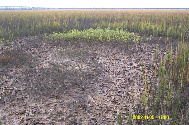
10 Field Efforts Differential GPS controlled point observations GPS field digitization Calibration panels Ground photo comparison View looking southwest View looking northeast
11 Manual digitization- Methods Imagery Photography and GeoScanner (0.5m) Software ArcView Habitat Digitizer Hamlin: Broad: Patch reefs especially labor intensive. Experience influences results strongly. Field work essential Cost Benefit Effort 7 Results 8

12 Manual Digitization- No Minimum Mapping Unit
13 Image segmentation - Methods Imagery GeoScanner (0.5m) Software - ecognition Broad: Experience influences results strongly. Cost Benefit Effort 7 Results 7+

14 ecognition Initial Segmentation
15 Methods Unsupervised spectral clustering- Imagery GeoScanner (0.5m) Software - ERDAS Imagine (ISODATA) Hamlin: Broad: Three good clusters. Good at patch reefs Similar results to Hamlin. More problems with shadows Cost Benefit Effort 4 Results - 4

16 Oyster with mud High profile oyster Vegetation Unsupervised Spectral Clustering
17 Methods Supervised spectral clustering- Imagery GeoScanner (0.5m) Software ERDAS Imagine Hamlin: Broad: Better results than unsupervised. More confusion than unsupervised. AOIs pulling in mixed signatures. Cost Benefit Effort 5 Results - 5

18 Supervised Spectral Clustering Oyster with mud High profile oyster Low profile oyster
19 Texture Analysis - Methods Imagery GeoScanner (0.5m) Software Feature Analyst (ArcView Environment) Broad Hamlin: Excellent results on patch reefs. Encouraging results on fringing reefs. Same as Broad. Cost Benefit Effort = 3 Results = 7

20 Feature Analyst 1st Pass
21 Methods Derived products (NDVI, PCA) - Imagery GeoScanner (0.25m) Software - ERDAS Imagine Hamlin: Broad: NDVI adequate segmentation tool. PCA only three components. NDVI had promising results but limited due to spartina response, confusion. Cost Benefit Effort = 7 Results = 8

22 Unsupervised Clustering on NDVI Segmented Image Vegetation Textured wet mud Wet oyster, Spartina, mud Mud Water High profile oyster High profile oyster with mud Washed shell Low profile oyster
23 Relative Detail 10 = all strata - all boundaries 3 = some boundaries Results ecognition Visual Interp cluster (s) cluster (U) Feature Analyst
24 Relative Effort 10 = high skill, complex process, long time 1= low skill, simple, quick Effort ecognition Visual Interp cluster (s) cluster (U) Feature Analyst

25 GeoScanner - Analog - Strata Summary 0.50 m = Washed shell, other oyster Patch reefs easy, fringing reef more difficult 0.25m = Washed shell, several live strata Patch reefs easy, fringing reefs easy 1:8K = Washed shell, more than one other oyster Patch reefs easy, fringing reef slightly more difficult 1:5K = Washed shell, several live strata Patch reefs easy, fringing reefs easy 1:3K and 1:2K = Continued improvement on above.


26 Strata Examples Washed Shell (Dead) High Profile with Mud Low Profile High Profile

27 Summary GeoScanner 0.5 meter captures reef boundaries 90% of patch reefs 70% of fringing reefs No strata except washed shell and other GeoScanner 0.25 meter captures more fringing reefs and several strata Challenges Spartina with oyster mixed in Textured mud vs. oyster Diatoms affect oyster s appearance on imagery


28
29 Proposed Approach Polygon Information (Feature Analysis) Extent/Configuration Fringe/Patch Good representation of the actual feature of interest the oyster reef Raster Information (Clustering) Pixel-by-pixel classification Oyster red and yellow Mud brown Precise representation of mix of features that makes an oyster reef Poor representation of the feature oyster reef Integrated Data (management solution) Boundary allows determination of reef erosion or expansion Raster data allows determination of reef condition
30 Summary Multi-spectral 0.25-meter imagery captures necessary detail to extract oyster reefs with multiple software Feature Analyst creates single attribute polygonal data Imagine ISODATA creates four unique classes Need to integrate these data sets for resource management and condition assessment

31
Land Cover Type Changes Related to. Oil and Natural Gas Drill Sites in a. Selected Area of Williams County, ND
 Land Cover Type Changes Related to Oil and Natural Gas Drill Sites in a Selected Area of Williams County, ND FR 3262/5262 Lab Section 2 By: Andrew Kernan Tyler Kaebisch Introduction: In recent years, there
Detecting artificial areas inside reference parcels. A technique to assist the evaluation of non-eligibility in agriculture
 1 Detecting artificial areas inside reference parcels. A technique to assist the evaluation of non-eligibility in agriculture R. de Kok, C.Wirnhardt EC Joint Research Centre, IES Motivation Wall-to-wall
Towards a Management Plan for a Tropical Reef-Lagoon System Using Airborne Multispectral Imaging and GIS
 Towards a Management Plan for a Tropical Reef-Lagoon System Using Airborne Multispectral Imaging and GIS This paper was presented at the Fourth International Conference on Remote Sensing for Marine and
Figure 3: Map showing the extension of the six surveyed areas in Indonesia analysed in this study.
 5 2. METHODOLOGY The present study consisted of two phases. First a test study was conducted to evaluate whether Landsat 7 images could be used to identify the habitat of humphead wrasse in Indonesia.
Land cover change methods. Ned Horning
 Land cover change methods Ned Horning Version: 1.0 Creation Date: 2004-01-01 Revision Date: 2004-01-01 License: This document is licensed under a Creative Commons Attribution-Share Alike 3.0 Unported License.
University of Kota Kota
 University of Kota Kota Diploma in Remote Sensing and GIS SYLLABUS 2017 1 Diploma in Remote Sensing And GIS (DRSGIS) Exam.-2016-17 Title of the Course: Diploma in Remote Sensing And GIS Duration of the
[GEOMETRIC CORRECTION, ORTHORECTIFICATION AND MOSAICKING]
![[GEOMETRIC CORRECTION, ORTHORECTIFICATION AND MOSAICKING]](/thumbs/78/78211997.jpg "[GEOMETRIC CORRECTION, ORTHORECTIFICATION AND MOSAICKING]") 2013 Ogis-geoInfo Inc. IBEABUCHI NKEMAKOLAM.J [GEOMETRIC CORRECTION, ORTHORECTIFICATION AND MOSAICKING] [Type the abstract of the document here. The abstract is typically a short summary of the contents
2013 Ogis-geoInfo Inc. IBEABUCHI NKEMAKOLAM.J [GEOMETRIC CORRECTION, ORTHORECTIFICATION AND MOSAICKING] [Type the abstract of the document here. The abstract is typically a short summary of the contents
University of New Orleans. Sarah Fearnley University of New Orleans Pontchartrain Institute for Environmental Sciences
 University of New Orleans ScholarWorks@UNO Pontchartrain Institute Reports and Studies Pontchartrain Institute for Environmental Sciences (PIES) 2-2009 Louisiana Barrier Island Comprehensive Monitoring
F2 - Fire 2 module: Remote Sensing Data Classification
 F2 - Fire 2 module: Remote Sensing Data Classification F2.1 Task_1: Supervised and Unsupervised classification examples of a Landsat 5 TM image from the Center of Portugal, year 2005 F2.1 Task_2: Burnt
DIFFERENTIAL APPROACH FOR MAP REVISION FROM NEW MULTI-RESOLUTION SATELLITE IMAGERY AND EXISTING TOPOGRAPHIC DATA
 DIFFERENTIAL APPROACH FOR MAP REVISION FROM NEW MULTI-RESOLUTION SATELLITE IMAGERY AND EXISTING TOPOGRAPHIC DATA Costas ARMENAKIS Centre for Topographic Information - Geomatics Canada 615 Booth Str., Ottawa,
An Introduction to Geomatics. Prepared by: Dr. Maher A. El-Hallaq خاص بطلبة مساق مقدمة في علم. Associate Professor of Surveying IUG
 An Introduction to Geomatics خاص بطلبة مساق مقدمة في علم الجيوماتكس Prepared by: Dr. Maher A. El-Hallaq Associate Professor of Surveying IUG 1 Airborne Imagery Dr. Maher A. El-Hallaq Associate Professor
Michigan Technological University. Characterization of Unpaved Road Condition Through the Use of Remote Sensing
 Michigan Technological University Characterization of Unpaved Road Condition Through the Use of Remote Sensing Deliverable 6-A: A Demonstration Mission Planning System for use in Remote Sensing the Phenomena
APPLICATIONS AND LESSONS LEARNED WITH AIRBORNE MULTISPECTRAL IMAGING
 APPLICATIONS AND LESSONS LEARNED WITH AIRBORNE MULTISPECTRAL IMAGING James M. Ellis and Hugh S. Dodd The MapFactory and HJW Walnut Creek and Oakland, California, U.S.A. ABSTRACT Airborne digital frame
The techniques with ERDAS IMAGINE include:
 The techniques with ERDAS IMAGINE include: 1. Data correction - radiometric and geometric correction 2. Radiometric enhancement - enhancing images based on the values of individual pixels 3. Spatial enhancement
Visualizing a Pixel. Simulate a Sensor s View from Space. In this activity, you will:
 Simulate a Sensor s View from Space In this activity, you will: Measure and mark pixel boundaries Learn about spatial resolution, pixels, and satellite imagery Classify land cover types Gain exposure to
APCAS/10/21 April 2010 ASIA AND PACIFIC COMMISSION ON AGRICULTURAL STATISTICS TWENTY-THIRD SESSION. Siem Reap, Cambodia, April 2010
 APCAS/10/21 April 2010 Agenda Item 8 ASIA AND PACIFIC COMMISSION ON AGRICULTURAL STATISTICS TWENTY-THIRD SESSION Siem Reap, Cambodia, 26-30 April 2010 The Use of Remote Sensing for Area Estimation by Robert
Remote Sensing. The following figure is grey scale display of SPOT Panchromatic without stretching.
 Remote Sensing Objectives This unit will briefly explain display of remote sensing image, geometric correction, spatial enhancement, spectral enhancement and classification of remote sensing image. At
Advanced Techniques in Urban Remote Sensing
 Advanced Techniques in Urban Remote Sensing Manfred Ehlers Institute for Geoinformatics and Remote Sensing (IGF) University of Osnabrueck, Germany mehlers@igf.uni-osnabrueck.de Contents Urban Remote Sensing:
DetailedShoreChange at Chesapeake BayDune Systems. C.S.Hardaway,Jr. D.A.Milligan K.Farnsworth S. Dewing
 DetailedShoreChange at Chesapeake BayDune Systems C.S.Hardaway,Jr. D.A.Milligan K.Farnsworth S. Dewing November 2001 Detailed Shore Change at Chesapeake Bay Dune Systems by C. S. Hardaway, Jr. D. A. Milligan
Leica ADS80 - Digital Airborne Imaging Solution NAIP, Salt Lake City 4 December 2008
 Luzern, Switzerland, acquired at 5 cm GSD, 2008. Leica ADS80 - Digital Airborne Imaging Solution NAIP, Salt Lake City 4 December 2008 Shawn Slade, Doug Flint and Ruedi Wagner Leica Geosystems AG, Airborne
Land Cover Analysis to Determine Areas of Clear-cut and Forest Cover in Olney, Montana. Geob 373 Remote Sensing. Dr Andreas Varhola, Kathry De Rego
 1 Land Cover Analysis to Determine Areas of Clear-cut and Forest Cover in Olney, Montana Geob 373 Remote Sensing Dr Andreas Varhola, Kathry De Rego Zhu an Lim (14292149) L2B 17 Apr 2016 2 Abstract Montana
Wetlands Investigation Utilizing GIS and Remote Sensing Technology for Lucas County, Ohio: a hybrid analysis.
 Wetlands Investigation Utilizing GIS and Remote Sensing Technology for Lucas County, Ohio: a hybrid analysis. Update on current wetlands research in GISAG Nathan Torbick Spring 2003 Component One Remote
COMPARING SPECTRAL AND OBJECT BASED APPROACHES FOR CLASSIFICATION AND TRANSPORTATION FEATURE EXTRACTION FROM HIGH RESOLUTION MULTISPECTRAL IMAGERY
 COMPARING SPECTRAL AND OBJECT BASED APPROACHES FOR CLASSIFICATION AND TRANSPORTATION FEATURE EXTRACTION FROM HIGH RESOLUTION MULTISPECTRAL IMAGERY Sunil Reddy Repaka, Research Assistant Dennis D. Truax,
Monitoring the vegetation success of a rehabilitated mine site using multispectral UAV imagery. Tim Whiteside & Renée Bartolo, eriss
 Monitoring the vegetation success of a rehabilitated mine site using multispectral UAV imagery Tim Whiteside & Renée Bartolo, eriss About the Supervising Scientist Main roles Working to protect the environment
Urban Feature Classification Technique from RGB Data using Sequential Methods
 Urban Feature Classification Technique from RGB Data using Sequential Methods Hassan Elhifnawy Civil Engineering Department Military Technical College Cairo, Egypt Abstract- This research produces a fully
Basic Digital Image Processing. The Structure of Digital Images. An Overview of Image Processing. Image Restoration: Line Drop-outs
 Basic Digital Image Processing A Basic Introduction to Digital Image Processing ~~~~~~~~~~ Rev. Ronald J. Wasowski, C.S.C. Associate Professor of Environmental Science University of Portland Portland,
A MULTISTAGE APPROACH FOR DETECTING AND CORRECTING SHADOWS IN QUICKBIRD IMAGERY
 A MULTISTAGE APPROACH FOR DETECTING AND CORRECTING SHADOWS IN QUICKBIRD IMAGERY Jindong Wu, Assistant Professor Department of Geography California State University, Fullerton 800 North State College Boulevard
Costal region of northern Peru, the pacific equatorial dry forest there is recognised for its unique endemic biodiversity
 S.Baena@kew.org http://www.kew.org/gis/ Costal region of northern Peru, the pacific equatorial dry forest there is recognised for its unique endemic biodiversity Highly threatened ecosystem affected by
CLASSIFICATION OF HISTORIC LAKES AND WETLANDS
 CLASSIFICATION OF HISTORIC LAKES AND WETLANDS Golden Valley, Minnesota Image Analysis Heather Hegi & Kerry Ritterbusch 12/13/2010 Bassett Creek and Theodore Wirth Golf Course, 1947 FR 5262 Remote Sensing
ERDAS IMAGINE Suite Comparison
 ERDAS Suite Comparison A brief comparison of Essentials, Advantage and Professional age 1 of 7 Overview This document provides a brief comparison of the main features and capabilities found within the
White Paper. Medium Resolution Images and Clutter From Landsat 7 Sources. Pierre Missud
 White Paper Medium Resolution Images and Clutter From Landsat 7 Sources Pierre Missud Medium Resolution Images and Clutter From Landsat7 Sources Page 2 of 5 Introduction Space technologies have long been
GEOG432: Remote sensing Lab 3 Unsupervised classification
 GEOG432: Remote sensing Lab 3 Unsupervised classification Goal: This lab involves identifying land cover types by using agorithms to identify pixels with similar Digital Numbers (DN) and spectral signatures
A (very) brief introduction to Remote Sensing: From satellites to maps!
 brief introduction to Remote Sensing: From satellites to maps!") Spatial Data Analysis and Modeling for Agricultural Development, with R - Workshop A (very) brief introduction to Remote Sensing: From satellites to maps! Earthlights DMSP 1994-1995 https://wikimedia.org/
Spatial Data Analysis and Modeling for Agricultural Development, with R - Workshop A (very) brief introduction to Remote Sensing: From satellites to maps! Earthlights DMSP 1994-1995 https://wikimedia.org/
Lesson 9: Multitemporal Analysis
 Lesson 9: Multitemporal Analysis Lesson Description Multitemporal change analyses require the identification of features and measurement of their change through time. In this lesson, we will examine vegetation
Digital Image Classification for Monitoring Landcover
 Digital Image Classification for Monitoring Landcover Trainer Khaled Mashfiq 2 / April / 2018 Training Module A1 Session 2 Advanced Application of Geospatial Information technology for Decision Support
Preparing Remote Sensing Data for Natural Resources Mapping (image enhancement, rectifications )
") Preparing Remote Sensing Data for Natural Resources Mapping (image enhancement, rectifications ) Why is this important What are the major approaches Examples of digital image enhancement Follow up exercises
Preparing Remote Sensing Data for Natural Resources Mapping (image enhancement, rectifications ) Why is this important What are the major approaches Examples of digital image enhancement Follow up exercises
INTRODUCTION TO REMOTE SENSING AND ITS APPLICATIONS
 INTRODUCTION TO REMOTE SENSING AND ITS APPLICATIONS Prof. Dr. Abudeif A. Bakheit Geology Department. Faculty of Science Assiut University This representation was prepared from different power point representations
ANNEX IV ERDAS IMAGINE OPERATION MANUAL
 ANNEX IV ERDAS IMAGINE OPERATION MANUAL Table of Contents 1. TOPIC 1 DATA IMPORT...1 1.1. Importing SPOT DATA directly from CDROM... 1 1.2. Importing SPOT (Panchromatic) using GENERIC BINARY... 7 1.3.
Use of digital aerial camera images to detect damage to an expressway following an earthquake
 Use of digital aerial camera images to detect damage to an expressway following an earthquake Yoshihisa Maruyama & Fumio Yamazaki Department of Urban Environment Systems, Chiba University, Chiba, Japan.
TRACS A-B-C Acquisition and Processing and LandSat TM Processing
 TRACS A-B-C Acquisition and Processing and LandSat TM Processing Mark Hess, Ocean Imaging Corp. Kevin Hoskins, Marine Spill Response Corp. TRACS: Level A AIRCRAFT Ocean Imaging Corporation Multispectral/TIR
A Final Report to. The New Hampshire Estuaries Project. Submitted by
 OYSTER (CRASSOSTREA VIRGINICA) REEF MAPPING IN THE GREAT BAY ESTUARY, NEW HAMPSHIRE - 2003 A Final Report to The New Hampshire Estuaries Project Submitted by Raymond E. Grizzle and Melissa Brodeur University
LIFE ENVIRONMENT STRYMON
 LIFE ENVIRONMENT STRYMON Ecosystem Based Water Resources Management to Minimize Environmental Impacts from Agriculture Using State of the Art Modeling Tools in Strymonas Basin LIFE03 ENV/GR/000217 Task
Baldwin and Mobile Counties, AL Orthoimagery Project Report. Submitted: March 23, 2016
 2015 Orthoimagery Project Report Submitted: Prepared by: Quantum Spatial, Inc 523 Wellington Way, Suite 375 Lexington, KY 40503 859-277-8700 Page i of iii Contents Project Report 1. Summary / Scope...
Spatial Analyst is an extension in ArcGIS specially designed for working with raster data.
 Spatial Analyst is an extension in ArcGIS specially designed for working with raster data. 1 Do you remember the difference between vector and raster data in GIS? 2 In Lesson 2 you learned about the difference
Palm Beach County. Estuarine Habitat Mapping
 Palm Beach County Estuarine Habitat Mapping Coastal Habitat Integrated Mapping and Monitoring Program (CHIMMP) April 29, 2014 Eric Anderson, Environmental Analyst Palm Beach County Department of Environmental
Cellular automata applied in remote sensing to implement contextual pseudo-fuzzy classication - The Ninth International Conference on Cellular
 INDEX Introduction Spectral and Contextual Classification of Satellite Images Classical aplications of Cellular Automata in Remote Sensing Classification of Satellite Images with Cellular Automata (ACA)
MPA Baseline Program. Annual Progress Report
 MPA Baseline Program Annual Progress Report Principal Investigators please use this form to submit your MPA Baseline Program project annual report, including an update on activities completed over the
GEOG432: Remote sensing Lab 3 Unsupervised classification
 GEOG432: Remote sensing Lab 3 Unsupervised classification Goal: This lab involves identifying land cover types by using agorithms to identify pixels with similar Digital Numbers (DN) and spectral signatures
Seasonal Progression of the Normalized Difference Vegetation Index (NDVI)
") Seasonal Progression of the Normalized Difference Vegetation Index (NDVI) For this exercise you will be using a series of six SPOT 4 images to look at the phenological cycle of a crop. The images are SPOT
Seasonal Progression of the Normalized Difference Vegetation Index (NDVI) For this exercise you will be using a series of six SPOT 4 images to look at the phenological cycle of a crop. The images are SPOT
Using High-Res. Orthoimagery for Environmental Change Detection & Analysis in Northern Alaska
 Using High-Res. Orthoimagery for Environmental Change Detection & Analysis in Northern Alaska William F. Manley Leanne R. Lestak INSTAAR, University of Colorado INSTAAR, University of Colorado 1 Talk Outline
Module 11 Digital image processing
 Introduction Geo-Information Science Practical Manual Module 11 Digital image processing 11. INTRODUCTION 11-1 START THE PROGRAM ERDAS IMAGINE 11-2 PART 1: DISPLAYING AN IMAGE DATA FILE 11-3 Display of
Separation of crop and vegetation based on Digital Image Processing
 Separation of crop and vegetation based on Digital Image Processing Mayank Singh Sakla 1, Palak Jain 2 1 M.TECH GEOMATICS student, CEPT UNIVERSITY 2 M.TECH GEOMATICS student, CEPT UNIVERSITY Word Limit
USE OF DIGITAL AERIAL IMAGES TO DETECT DAMAGES DUE TO EARTHQUAKES
 USE OF DIGITAL AERIAL IMAGES TO DETECT DAMAGES DUE TO EARTHQUAKES Fumio Yamazaki 1, Daisuke Suzuki 2 and Yoshihisa Maruyama 3 ABSTRACT : 1 Professor, Department of Urban Environment Systems, Chiba University,
Present and future of marine production in Boka Kotorska
 Present and future of marine production in Boka Kotorska First results from satellite remote sensing for the breeding areas of filter feeders in the Bay of Kotor INTRODUCTION Environmental monitoring is
Digitization of Trail Network Using Remotely-Sensed Data in the CFB Suffield National Wildlife Area
 Digitization of Trail Network Using Remotely-Sensed Data in the CFB Suffield National Wildlife Area Brent Smith DLE 5-5 and Mike Tulis G3 GIS Technician Department of National Defence 27 March 2007 Introduction
Keywords: Agriculture, Olive Trees, Supervised Classification, Landsat TM, QuickBird, Remote Sensing.
 Classification of agricultural fields by using Landsat TM and QuickBird sensors. The case study of olive trees in Lesvos island. Christos Vasilakos, University of the Aegean, Department of Environmental
Annual Progress Report for Makaha Valley Vegetation Mapping Analysis Project Update: January 1, 2014 September 30 th, 2014
 Annual Progress Report for Makaha Valley Vegetation Mapping Analysis Project Update: January 1, 2014 September 30 th, 2014 Evaluation of Three Very High Resolution Remote Sensing Technologies for Vegetation
GIS Data Collection. Remote Sensing
 GIS Data Collection Remote Sensing Data Collection Remote sensing Introduction Concepts Spectral signatures Resolutions: spectral, spatial, temporal Digital image processing (classification) Other systems
large area By Juan Felipe Villegas E Scientific Colloquium Forest information technology
 A comparison of three different Land use classification methods based on high resolution satellite images to find an appropriate methodology to be applied on a large area By Juan Felipe Villegas E Scientific
A COMPARISON OF COVERTYPE DELINEATIONS FROM AUTOMATED IMAGE SEGMENTATION OF INDEPENDENT AND MERGED IRS AND LANDSAT TM IMAGE-BASED DATA SETS
 A COMPARISON OF COVERTYPE DELINEATIONS FROM AUTOMATED IMAGE SEGMENTATION OF INDEPENDENT AND MERGED IRS AND LANDSAT TM IMAGE-BASED DATA SETS M. Riley, Space Imaging Solutions USDA Forest Service, Region
GE 113 REMOTE SENSING
 GE 113 REMOTE SENSING Topic 8. Image Classification and Accuracy Assessment Lecturer: Engr. Jojene R. Santillan jrsantillan@carsu.edu.ph Division of Geodetic Engineering College of Engineering and Information
Enhancement of Multispectral Images and Vegetation Indices
 Enhancement of Multispectral Images and Vegetation Indices ERDAS Imagine 2016 Description: We will use ERDAS Imagine with multispectral images to learn how an image can be enhanced for better interpretation.
Application of Linear Spectral unmixing to Enrique reef for classification
 Application of Linear Spectral unmixing to Enrique reef for classification Carmen C. Zayas-Santiago University of Puerto Rico Mayaguez Marine Sciences Department Stefani 224 Mayaguez, PR 00681 c_castula@hotmail.com
TIDAL WETLAND CLASSIFICATION FROM LANDSAT IMAGERY USING AN INTEGRATED PIXEL-BASED AND OBJECT-BASED CLASSIFICATION APPROACH
 TIDAL WETLAND CLASSIFICATION FROM LANDSAT IMAGERY USING AN INTEGRATED PIXEL-BASED AND OBJECT-BASED CLASSIFICATION APPROACH James D. Hurd, Research Associate Daniel L. Civco, Director and Professor Center
Aerial photography: Principles. Frame capture sensors: Analog film and digital cameras
 Aerial photography: Principles Frame capture sensors: Analog film and digital cameras Overview Introduction Frame vs scanning sensors Cameras (film and digital) Photogrammetry Orthophotos Air photos are
Classification in Image processing: A Survey
 Classification in Image processing: A Survey Rashmi R V, Sheela Sridhar Department of computer science and Engineering, B.N.M.I.T, Bangalore-560070 Department of computer science and Engineering, B.N.M.I.T,
Revised Work Plan and Budget for Project:
 Revised Work Plan and Budget for Project: Nearshore Substrate Mapping and Change Analysis using Historical and Concurrent Multi-spectral Aerial Imagery. 8/17/2011 Project Leader and PI: Dr. Jan Svejkovsky
36. Global Positioning System
 36. Introduction to the Global Positioning System (GPS) Why do we need GPS? Position: a basic need safe sea travel, crowed skies, resource management, legal questions Positioning: a challenging job local
Using Color-Infrared Imagery for Impervious Surface Analysis. Chris Behee City of Bellingham Planning & Community Development
 Using Color-Infrared Imagery for Impervious Surface Analysis. Chris Behee City of Bellingham Planning & Community Development NW GIS Users Group - March 18, 2005 Outline What is Color Infrared Imagery?
What can we check with VHR Pan and HR multispectral imagery?
 2008 CwRS Campaign Kick-off meeting, Ispra, 03-04 April 2008 1 What can we check with VHR Pan and HR multispectral imagery? Pavel MILENOV GeoCAP, Agriculture Unit, JRC 2008 CwRS Campaign Kick-off meeting,
Radar Observations in the German Wadden Sea
 Radar Observations in the German Wadden Sea Martin Gade (1), Sabrina Melchionna (1,2) and Linnea Kemme (1,3) (1)Universität Hamburg, 20146 Hamburg, Germany, Tel: +49 40 42838-5450, Fax: -7471, E-mail:
PROGRESS REPORT MAPPING THE RIPARIAN VEGETATION USING MULTIPLE HYPERSPECTRAL AIRBORNE IMAGERY OVER THE REPUBLICAN RIVER, NEBRASKA
 PROGRESS REPORT MAPPING THE RIPARIAN VEGETATION USING MULTIPLE HYPERSPECTRAL AIRBORNE IMAGERY OVER THE REPUBLICAN RIVER, NEBRASKA PROJECT SUMMARY By Dr. Ayse Irmak and Dr. Sami Akasheh As the dependency
REMOTE SENSING WITH DRONES. YNCenter Video Conference Chang Cao
 REMOTE SENSING WITH DRONES YNCenter Video Conference Chang Cao 08-28-2015 28 August 2015 2 Drone remote sensing It was first utilized in military context and has been given great attention in civil use
Evaluating the Effects of Shadow Detection on QuickBird Image Classification and Spectroradiometric Restoration
 Remote Sens. 2013, 5, 4450-4469; doi:10.3390/rs5094450 Article OPEN ACCESS Remote Sensing ISSN 2072-4292 www.mdpi.com/journal/remotesensing Evaluating the Effects of Shadow Detection on QuickBird Image
Project Planning and Cost Estimating
 CHAPTER 17 Project Planning and Cost Estimating 17.1 INTRODUCTION Previous chapters have outlined and detailed technical aspects of photogrammetry. The basic tasks and equipment required to create various
Orthoimagery Standards. Chatham County, Georgia. Jason Lee and Noel Perkins
 1 Orthoimagery Standards Chatham County, Georgia Jason Lee and Noel Perkins 2 Table of Contents Introduction... 1 Objective... 1.1 Data Description... 2 Spatial and Temporal Environments... 3 Spatial Extent
Module 3 Introduction to GIS. Lecture 8 GIS data acquisition
 Module 3 Introduction to GIS Lecture 8 GIS data acquisition GIS workflow Data acquisition (geospatial data input) GPS Remote sensing (satellites, UAV s) LiDAR Digitized maps Attribute Data Management Data
Application of Satellite Image Processing to Earth Resistivity Map
 Application of Satellite Image Processing to Earth Resistivity Map KWANCHAI NORSANGSRI and THANATCHAI KULWORAWANICHPONG Power System Research Unit School of Electrical Engineering Suranaree University
MPA Baseline Program. Annual Progress Report
 MPA Baseline Program Annual Progress Report Principal Investigators - please use this form to submit your MPA Baseline Program project annual report, including an update on activities completed over the
Analysis of Reference Tidal Channel Plan Form For the Montezuma Wetlands Restoration Project
 Analysis of Reference Tidal Channel Plan Form For the Montezuma Wetlands Restoration Project Sarah Pearce, Geomorphologist Joshua N. Collins, Project Manager Contribution No. 80 May, 2004 ACKNOWLEDGEMENTS
IceTrendr - Polygon. 1 contact: Peder Nelson Anne Nolin Polygon Attribution Instructions
 INTRODUCTION We want to describe the process that caused a change on the landscape (in the entire area of the polygon outlined in red in the KML on Google Earth), and we want to record as much as possible
High Resolution Multi-spectral Imagery
 High Resolution Multi-spectral Imagery Jim Baily, AirAgronomics AIRAGRONOMICS Having been involved in broadacre agriculture until 2000 I perceived a need for a high resolution remote sensing service to
Remote Sensing And Gis Application in Image Classification And Identification Analysis.
 Quest Journals Journal of Research in Environmental and Earth Science Volume 3~ Issue 5 (2017) pp: 55-66 ISSN(Online) : 2348-2532 www.questjournals.org Research Paper Remote Sensing And Gis Application
IDENTIFICATION AND MAPPING OF HAWAIIAN CORAL REEFS USING HYPERSPECTRAL REMOTE SENSING
 IDENTIFICATION AND MAPPING OF HAWAIIAN CORAL REEFS USING HYPERSPECTRAL REMOTE SENSING Jessica Frances N. Ayau College of Education University of Hawai i at Mānoa Honolulu, HI 96822 ABSTRACT Coral reefs
Land Cover Change in Saipan, CNMI from 1978 to 2009
 International Journal of Environment and Resource Volume 5, 2016 doi: 10.14355/ijer.2016.05.002 www.ij-er.org Land Cover Change in Saipan, CNMI from 1978 to 2009 Yuming Wen *1, Derek Chambers 2 1 Water
Flagler Park Living Shoreline Monitoring Vincent Encomio, Pam Hopkins, Katie Tiling, Josh Mills 9/23/2016
 FLORIDA OCEANOGRAPHIC SOCIETY Flagler Park Living Shoreline Monitoring 2015-2016 Vincent Encomio, Pam Hopkins, Katie Tiling, Josh Mills 9/23/2016 Flagler Living Shoreline Monitoring Summary Constructed
Image Analysis based on Spectral and Spatial Grouping
 Image Analysis based on Spectral and Spatial Grouping B. Naga Jyothi 1, K.S.R. Radhika 2 and Dr. I. V.Murali Krishna 3 1 Assoc. Prof., Dept. of ECE, DMS SVHCE, Machilipatnam, A.P., India 2 Assoc. Prof.,
Satellite data processing and analysis: Examples and practical considerations
 Satellite data processing and analysis: Examples and practical considerations Dániel Kristóf Ottó Petrik, Róbert Pataki, András Kolesár International LCLUC Regional Science Meeting in Central Europe Sopron,
Using Soil Productivity to Assess Agricultural Land Values in North Dakota
 Using Soil Productivity to Assess Agricultural Land Values in North Dakota STUDENT HANDOUT Overview Why is assigning a true and full value to agricultural land parcels important? Agricultural production
Coral Reef Remote Sensing
 Coral Reef Remote Sensing Spectral, Spatial, Temporal Scaling Phillip Dustan Sensor Spatial Resolutio n Number of Bands Useful Bands coverage cycle Operation Landsat 80m 2 2 18 1972-97 Thematic 30m 7
CHAPTER 144. Interpretation of Shoreline Position from Aerial Photographs John S. Fisher 1 Margery F. Overton 2
 CHAPTER 144 Interpretation of Shoreline Position from Aerial Photographs John S. Fisher 1 Margery F. Overton 2 Abstract A review of some of the potential sources of error associated with the use of aerial
DISCRIMINANT FUNCTION CHANGE IN ERDAS IMAGINE
 DISCRIMINANT FUNCTION CHANGE IN ERDAS IMAGINE White Paper April 20, 2015 Discriminant Function Change in ERDAS IMAGINE For ERDAS IMAGINE, Hexagon Geospatial has developed a new algorithm for change detection
AUTOMATIC DETECTION OF HEDGES AND ORCHARDS USING VERY HIGH SPATIAL RESOLUTION IMAGERY
 AUTOMATIC DETECTION OF HEDGES AND ORCHARDS USING VERY HIGH SPATIAL RESOLUTION IMAGERY Selim Aksoy Department of Computer Engineering, Bilkent University, Bilkent, 06800, Ankara, Turkey saksoy@cs.bilkent.edu.tr
DISTINGUISHING URBAN BUILT-UP AND BARE SOIL FEATURES FROM LANDSAT 8 OLI IMAGERY USING DIFFERENT DEVELOPED BAND INDICES
 DISTINGUISHING URBAN BUILT-UP AND BARE SOIL FEATURES FROM LANDSAT 8 OLI IMAGERY USING DIFFERENT DEVELOPED BAND INDICES Mark Daryl C. Janiola (1), Jigg L. Pelayo (1), John Louis J. Gacad (1) (1) Central
HYPERSPECTRAL IMAGERY FOR SAFEGUARDS APPLICATIONS. International Atomic Energy Agency, Vienna, Austria
 HYPERSPECTRAL IMAGERY FOR SAFEGUARDS APPLICATIONS G. A. Borstad 1, Leslie N. Brown 1, Q.S. Bob Truong 2, R. Kelley, 3 G. Healey, 3 J.-P. Paquette, 3 K. Staenz 4, and R. Neville 4 1 Borstad Associates Ltd.,
remote sensing? What are the remote sensing principles behind these Definition
 Introduction to remote sensing: Content (1/2) Definition: photogrammetry and remote sensing (PRS) Radiation sources: solar radiation (passive optical RS) earth emission (passive microwave or thermal infrared
This week we will work with your Landsat images and classify them using supervised classification.
 GEPL 4500/5500 Lab 4: Supervised Classification: Part I: Selecting Training Sets Due: 4/6/04 This week we will work with your Landsat images and classify them using supervised classification. There are
Quantifying Change in. Quality Effects on a. Wetland Extent & Wetland. Western and Clark s Grebe Breeding Population
 Quantifying Change in Wetland Extent & Wetland Quality Effects on a Western and Clark s Grebe Breeding Population Eagle Lake, CA: 1998-2010 Renée E. Robison 1, Daniel W. Anderson 2,3, and Kristofer M.
SUGARCANE GROUND REFERENCE DATA OVER FOUR FIELDS IN SÃO PAULO STATE
 SUGARCANE GROUND REFERENCE DATA OVER FOUR FIELDS IN SÃO PAULO STATE Document created: 23/02/2016 by R.A. Molijn. INTRODUCTION This document is meant as a guide to the dataset and gives an insight into
SFR 406 Remote Sensing, Image Interpretation, and Forest Mapping Spring Semester 2015
 SFR 406 Remote Sensing, Image Interpretation, and Forest Mapping Spring Semester 2015 Course Description: Vertical and horizontal measurements from aerial photos, orthophotos, and topographic maps. Fundamentals