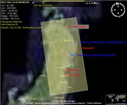
CALL359 JAPAN S EARTHQUAKE 2011, MARCH, 11
|
|
|
- Constance Cox
- 6 years ago
- Views:
Transcription


1 CALL359 JAPAN S EARTHQUAKE 2011, MARCH, 11 PM for International Charter Dr. Masahiko Nagai JAXA - AIT 25th Meeting of the International Charter May 12 th 2011
 Iwate Pref.")


2 on 2011, March, 11 at 14:46 (JST) Iwate Pref. Dead: 4,380 Missing: 3, km Other Pref. Dead: 64 Missing: 44 Miyagi Pref. Dead: 8,917 Missing: 5, km Fukushima Pref. Dead: 1,537 Missing: 622 The magnitude 9.0 Tohoku earthquake on March 11, The number of Dead and Missing Victims is 24,820. The number of refugees is more than 120,000. Completely Destroyed Houses is more than 65,000. Partially Destroyed Houses is more than 25,000. Economic loss is estimated more than 235 Billion USD by World Bank (Asahi Shinbun: 8 May, 2011)
")
3 (8 May, 2011) Aftershock Map Japan Earthquake Showing 1,181 earthquakes USGS (U.S. Geological Survey)


4
5
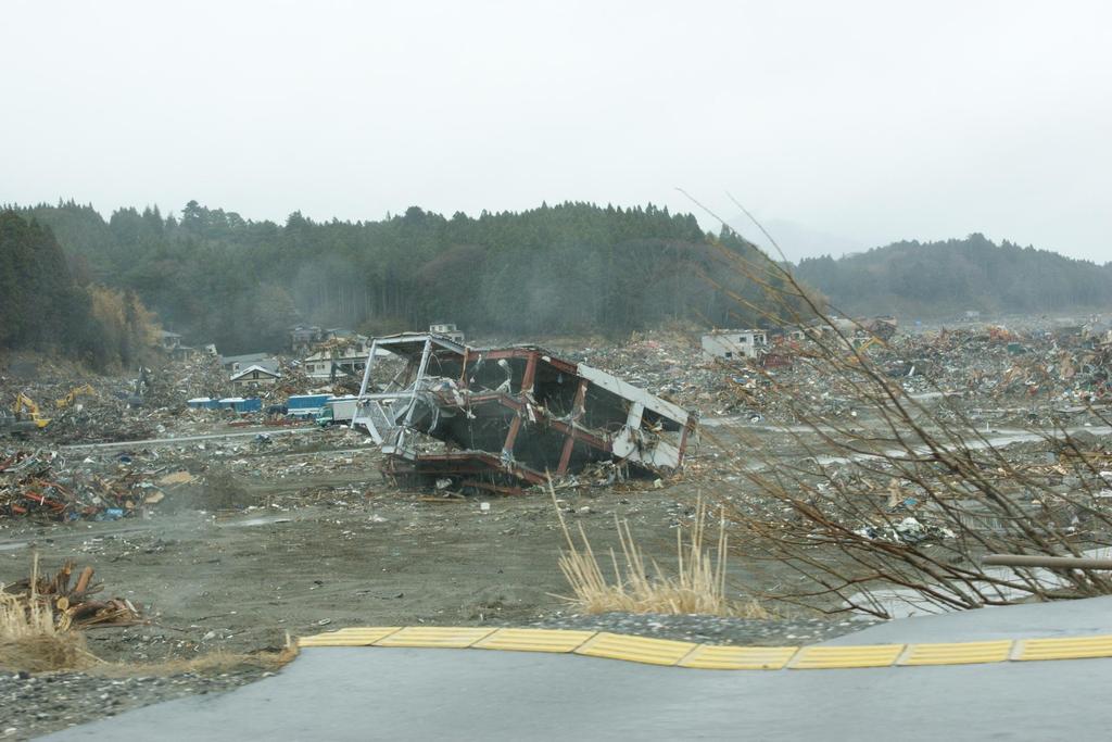
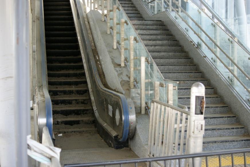
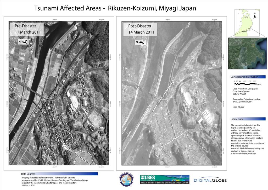
6 Rikuzentakata (19 April)

7 4F まで津波が Rikuzentakata (19 April)

8 いまだ水が引かず Rikuzentakata (19 April)

9 Rikuzentakata (19 April)
 2011.3.")
 Project Manager (PM)")


10 International Charter USGS Authorized User (AU) ESA On-Duty Operator (ODO) :24 activated by Japan Cabinet Emergency On-Call Officer (ECO) Project Manager (PM) AIT/GIC Dr.Nagai CSA ESA RADARSAT-1 ERS-2 USGS and ENVISAT CNES CNES SPOT-1, 2, 4 & 5 ESA NOAA NOAA-12, DLR14, 15, 16 & 17, POES CSA and GOES ISRO IRS ISRO KARI CONAE SAC-C CNSA JAXA ALOS USGS Landsat Disaster :46 at Tohoku, Japan End User (EU) Japanese Government DMC DMC Constellation CNSA USGS, DLR/KZI, SERTIT, CBERS UNOSAT,E- Decider, George Mason Univ., Auburn Univ., Clark Univ., ImageCat, Penn. Value-Added State Univ., Rochester Institute of Tech., Reseller (VAR) RIT, GISCorps, AIT, JAXA
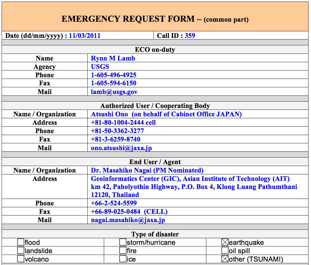

11 ERF (Emergency Request Form)

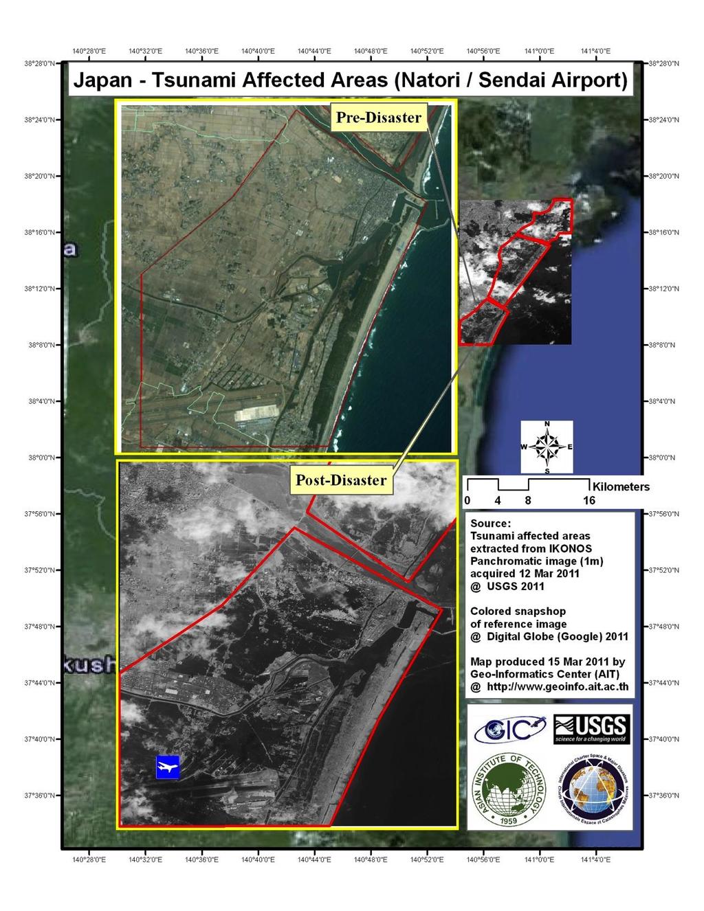
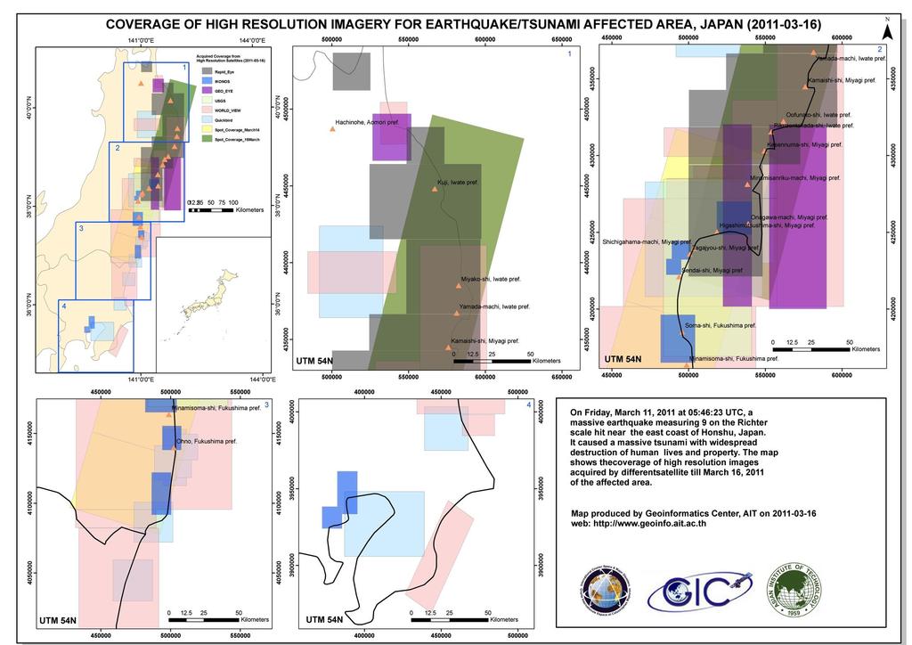
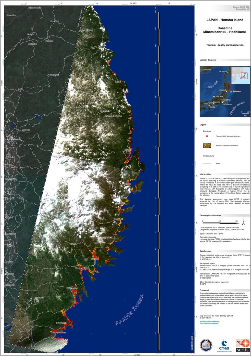
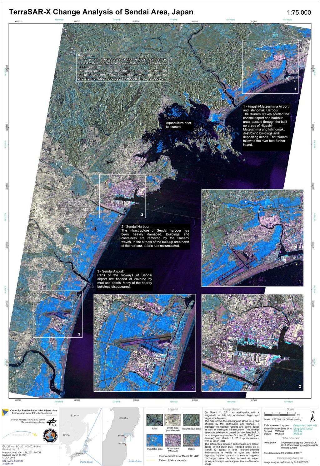
12 Major Affected Area After one week
13 International Charter Satellite List of International Charter Country. Regions USA Name of Satellite LANDSAT-5 LANDSAT-7 EO-1 IKONOS GeoEye Quickbird-2 Worldview-1 Worldview-2 Characteristics Medium Resolution Optical Sensor Medium Resolution Optical Sensor Medium Resolution Optical Sensor Very High Resolution Optical Sensor Very High Resolution Optical Sensor Very High Resolution Optical Sensor Very High Resolution Optical Sensor Very High Resolution Optical Sensor India Cartosat-2 High Resolution Optical Sensor Europe (ESA) ENVISAT C Band SAR Canada RADARSAT-2 C Band SAR Republic of KOMPSAT-2 High Resolution Optical Sensor Korea China HJ Medium Resolution Optical Sensor Germany TerraSAR-X X Band SAR RapidEye High Resolution Optical Sensor France SPOT-4 Medium Resolution Optical Sensor SPOT-5 FORMOSAT-2 High Resolution Optical Sensor High Resolution Optical Sensor
14
15
16
17

18
19

20
21 Summary on Utilization of satellite data products for the Japanese government ministries and agencies Cabinet Office Chief Cabinet Ministry of Land, Infrastructure, Transport and Tourism Ministry of Agriculture, Forestry and Fisheries Ministry of Education, Culture, Sports, Science and Technology Miyagi Prefecture We provided observation results, charter products related to Fukushima Nuclear Power Plant (wide-format printing). Furthermore, We also provided analyzed damage extent such as inundation area from Aomori - Chiba prefectures. We provided the images of before-and-after for concerned areas such as Sendai Airport and Fukushima Nuclear Power Plants. Regarding Fukushima Nuclear Power Plant, we continuously provided updated information mainly high resolution images. In addition, We also provided the maps of inundated area. We provided information regarding damage of coastal area. The information on Sanriku coastal area in Miyagi prefecture. We provided information regarding flood impacts on farm lands in damaged area by Tsunami. The data is utilized for validation of survey result by the Ministry and further improvement of low regarding recovery of agricultural land. We provided images related to Fukushima Nuclear Power Plant. We obtained information from International Charter, confirmed the SOS message at Onagawa supports park and provided information to the Miyagi prefecture.

22 I just noticed your before turning in. I ed my research associate who noticed this, and she says the coordinates (in decimal degrees) are approximately long: / lat: ). I ve attached a JPG of the post- image that she prepared. We ll put together a proper pre/post in the morning. Interestingly, this is in an area just above the worst of the tsunami damage? just where you d expect to find survivors. Looking at these images, the devastation is so pervasive, but we don t see people? just debris. And yet here is a very human cry for help visible from space! I so hope they re ok. Clark University
23 Concluding Remarks 4,506 scenes for Emergency Observation from the Charter 935 scenes for Archived Image 108 Value Added Products for supporting end users More than 1,430 access to the web site related disaster by central government ministries and local government Call 359 is still activated First two weeks for Rapid analysis and damage Extent First one month for Nuclear Plant Monitoring Analysis is still on going.
24 Lesson & Learned Avoid duplication Knowledge portal (Satellite Specification, Observation Period, Terminology, etc.) Management of data analysis Importance of Common Metadata Date (JST, UTM) Coordinate and land-name (Gazetteer) Extending of the Charter Duration of activation Number of scene Value added Reseller Collaboration with existing data registry More value added by existing data set (Local GIS dataset, Aerial photos, etc.) Moreover, Socio-economic data, News, etc.
Table Satellites used for observations by members of the Disaster Charter and others (except Daichi)
") 2.1.4 Cooperation with from overseas institutions JAXA asked Sentinel Asia and, on behalf of the Cabinet Office, the Disaster Charter to carry out emergency observations immediately after the earthquake
2.1.4 Cooperation with from overseas institutions JAXA asked Sentinel Asia and, on behalf of the Cabinet Office, the Disaster Charter to carry out emergency observations immediately after the earthquake
International Charter Space and Major Disasters
 International Charter Space and Major Disasters Sentinel Asia Joint Project Team Meeting July 7, 2010 Brenda Jones U.S. Geological Survey Charter Executive Secretariat Purpose An International agreement
Maximize Utilization of the performance of EOSs and strengthen. The First Steering Committee Secretariat JAXA
 Maximize Utilization of the performance of EOSs and strengthen cooperation among DPN/DAN The First Steering Committee Secretariat JAXA ALOS 2 observation is strong tool for disaster monitoring Wide area/range
Satellite Contributions to Disaster Monitoring - Japanese Earthquake and Tsunami Case in
 1 Satellite Contributions to Disaster Monitoring - Japanese Earthquake and Tsunami Case in 2011 - Akira Iwasaki, Satoshi Miyatani and Shinichi Nakasuka The University of Tokyo ASTER METI/NASA 2 We express
The Role of Urban Development Patterns in Mitigating the Effects of Tsunami Run-up: Final Report
 J-RAPID Final Symposium Sendai, Japan The Role of Urban Development Patterns in Mitigating the Effects of Tsunami Run-up: Final Report March 6, 2013 Fumio Yamazaki, Chiba University, Japan and Ronald T.
Workshop on Application of Satellite Technologies for Emergencies Preparedness, Management and Response in Asia-Pacific Region - Presentation
 2013/SOM1/EPWG/008a Agenda Item: 8.1.2 Workshop on Application of Satellite Technologies for Emergencies Preparedness, Management and Response in Asia-Pacific Region - Presentation Purpose: Information
Disaster Monitoring using remote sensing for the Great East Japan Earthauake
 Disaster Monitoring using remote sensing for the Great East Japan Earthauake Kazuo Yoshikawa, Yuki Okajima and Susumu Takagishi, Japan Key words: Disaster Monitoring, TerraSAR-X, Change Detection, Earthquake,
Geospatial Vision and Policies Korean Industry View 26 November, 2014 SI Imaging Services
 Geospatial Vision and Policies Korean Industry View 26 November, 2014 SI Imaging Services Distribution Limitation, SI Imaging Services Proprietary Data : The data contained in this document, without the
UNOSAT Satellite Imagery and GIS Solutions for DRR and Emergency Management
 UNOSAT Satellite Imagery and GIS Solutions for DRR and Emergency Management Francesco Pisano Director, Research, Technology Applications & Knowledge Systems January 2013 Introduction to UNOSAT 2 About
Disaster monitoring utilizing EO satellite system and DMS-Net
 Asia Geoinformation Forum 2012 Hanoi Vietnam, 19 th Sep. Disaster monitoring utilizing EO satellite system and DMSNet Susumu TAKAGISHI General Manager Satellite Business Division PASCO CORPORATION Agenda
Geoinformatics. S S Jadhav Department of Geography M J College, Jalgaon Mail: Cell:
 Geoinformatics S S Jadhav Department of Geography M J College, Jalgaon Mail: sahadeoj@gmail.com Cell: 9763267396 1 Satellite Remote Sensing: What is Remote Sensing? "Remote sensing is the science (and
Verification Tool for Safeguards. Satellite Imagery IAEA. Technical Seminar for Diplomats. Karen Steinmaus, SGIM-ICA. Vienna, 3-5 February 2009
 Technical Seminar for Diplomats Vienna, 3-5 February 2009 Satellite Imagery as Verification Tool for Safeguards Karen Steinmaus, SGIM-ICA International Atomic Energy Agency The Satellite Imagery Analysis
GEOSPATIAL CLOUD COMPUTING SOLUTION APPLIED TO NEW CALEDONIA FOREST MONITORING
 GEOSPATIAL CLOUD COMPUTING SOLUTION APPLIED TO NEW CALEDONIA FOREST MONITORING Worldview-3 30 cm Forgotten Coast New Caledonia DigitalGLobe 2016, Distribution and processing BLUECHAM SAS BLUECHAM SAS 101
Operational Space-Based Imaging Systems
 Operational Space-Based Imaging Systems R E M O T E S E N S I N G & G E O S PAT I A L A N A LY S I S L A B D O I : 2 0 A U G U S T, 2 0 1 6 Earth Observation Systems U.S. or foreign government systems
Data acquisition and access for the Congo Basin
 MRV Joint Workshop 22-24 June 2010, Guadalajara, Jalisco Mexico Data acquisition and access for the Congo Basin Landing Mané 1, Michael Brady 2, Chris Justice 3 and Alice Altstatt 3 1) Satellite Observatory
High Resolution Imaging Satellite Systems
 High Resolution Imaging Satellite Systems K. Jacobsen University of Hannover, Germany Keywords: high resolution space sensors, SAR ABSTRACT: The number of existing and announced high and very high resolution
Role of Landsat in Revolutionizing the Management of Natural Resources. Prof. UR Rao Former Chairman, ISRO, India
 Role of Landsat in Revolutionizing the Management of Natural Resources Prof. UR Rao Former Chairman, ISRO, India 40 Years of Landsat, June 6, 2012 Evolution of Remote Sensing Satellites TIROS Aerial Survey
9/12/2011. Training Course Remote Sensing Basic Theory & Image Processing Methods September 2011
 Training Course Remote Sensing Basic Theory & Image Processing Methods 19 23 September 2011 Popular Remote Sensing Sensors & their Selection Michiel Damen (September 2011) damen@itc.nl 1 Overview Low resolution
Drafting Committee for the Asia Pacific Plan of Action for Space Applications for Sustainable Development ( ) Republic of Korea
 Republic of Korea") Drafting Committee for the Asia Pacific Plan of Action for Space Applications for Sustainable Development (2018 2030) Republic of Korea Bangkok, Thailand 31 May 1 June 2018 김 1 KARI Introduction Government
Drafting Committee for the Asia Pacific Plan of Action for Space Applications for Sustainable Development (2018 2030) Republic of Korea Bangkok, Thailand 31 May 1 June 2018 김 1 KARI Introduction Government
Note that some are my own photos, comments, and opinions - Not necessary reflecting WB GFDRR s views
 1 Session 7: The Recovery Process Note that some are my own photos, comments, and opinions - Not necessary reflecting WB GFDRR s views Yuichi Ono Professor, International and Regional Cooperation Office
XSAT Ground Segment at CRISP
 XSAT Ground Segment at CRISP LIEW Soo Chin Head of Research, CRISP http://www.crisp.nus.edu.sg 5 th JPTM for Sentinel Asia Step-2, 14-16 Nov 2012, Daejeon, Korea Centre for Remote Imaging, Sensing and
Application of Satellite Communication System to Tsunami Early Warning System Satoru Ozawa
 Application of Satellite Communication System to Tsunami Early Warning System Satoru Ozawa Space Applications Program Systems Engineering Office Space Applications Mission Directorate Japan Aerospace Exploration
DETECTION OF BUILDING SIDE-WALL DAMAGE CAUSED BY THE 2011 TOHOKU, JAPAN EARTHQUAKE TSUNAMIS USING HIGH-RESOLUTION SAR IMAGERY
 10NCEE Tenth U.S. National Conference on Earthquake Engineering Frontiers of Earthquake Engineering July 21-25, 2014 Anchorage, Alaska DETECTION OF BUILDING SIDE-WALL DAMAGE CAUSED BY THE 2011 TOHOKU,
Dirty REMOTE SENSING Week 2 Interpreation
 Dirty REMOTE SENSING Week 2 Interpreation Earthobservation.wordpress.com Stuart Green Stuart.Green@teagasc.ie AERIAL PHOTOGRAPHIC INTERPRETATION http://airphotos.nrcan.gc.ca/photos101/photos101_info_e.php
Application of Satellite Remote Sensing for Natural Disasters Observation
 Application of Satellite Remote Sensing for Natural Disasters Observation Prof. Krištof Oštir, Ph.D. University of Ljubljana Faculty of Civil and Geodetic Engineering Outline Earth observation current
The Space Frequency Coordination Group (SFCG)
") The Space Frequency Coordination Group (SFCG) Edoardo Marelli ITU-R WP 7C Chairman and SFCG Executive Secretary ITU-R Seminar Manta (Ecuador) 20 September 2012 The SFCG in a nutshell The SFCG in a nutshell
The Space Frequency Coordination Group (SFCG) Edoardo Marelli ITU-R WP 7C Chairman and SFCG Executive Secretary ITU-R Seminar Manta (Ecuador) 20 September 2012 The SFCG in a nutshell The SFCG in a nutshell
Satellite and GPS technology
 Satellite and GPS technology Maryna Strydom (GIS Tg SA) Tel: (011) 441 6163 mstrydom@srk.co.za Overview General How Earth Observation Satellites work Uses of different EOS outputs How GPS work Types of
Application and potentials of RADAR and LiDAR technologies for forest carbon assessment in Pacific Island Countries
 Application and potentials of RADAR and LiDAR technologies for forest carbon assessment in Pacific Island Countries June 19th, 2012 PNGFA-JICA Workshop Masamichi HARAGUCHI (Kokusai Kogyo Co., Ltd.) Consultant
JECAM Guidelines: Definition of the Minimum Earth Observation Dataset Requirements
 JECAM Guidelines: Definition of the Minimum Earth Observation Dataset Requirements This document is version 1.0 of the JECAM minimum dataset requirements. It has been prepared based on 20 JECAM site reports,
Atmospheric Correction (including ATCOR)
") Technical Specifications Atmospheric Correction (including ATCOR) The data obtained by optical satellite sensors with high spatial resolution has become an invaluable tool for many groups interested in
Technical Specifications Atmospheric Correction (including ATCOR) The data obtained by optical satellite sensors with high spatial resolution has become an invaluable tool for many groups interested in
National SPace Organization
 National SPace Organization A center of innovation and excellence for space technology Bo Chen National Space Organization Presented at JPTM 2014, Sentinel Asia Yangon, Myanmar, 11/19-21 NARLabs-NSPO About
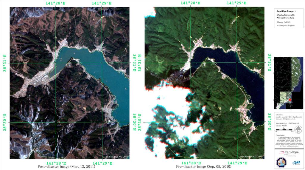
Use of Satellite Remote Sensing in Tsunami Damage Assessment
 Japan-Peru Workshop on Earthquake Disaster Mitigation, Lima 2005 Use of Satellite Remote Sensing in Tsunami Damage Assessment August 10, 2005 Fumio Yamazaki Chiba University, Chiba, Japan 1 World Tsunami
Overview of the Small Optical TrAnsponder (SOTA) Project
 Project") Overview of the Small Optical TrAnsponder (SOTA) Project Space Communications Laboratory Wireless Networks Research Center National Institute of Information and Communications Technology (NICT) Satellite
Overview of the Small Optical TrAnsponder (SOTA) Project Space Communications Laboratory Wireless Networks Research Center National Institute of Information and Communications Technology (NICT) Satellite
Introduction of CSRSR Image product processing systems in CSRSR Disaster monitoring and data processing
 3 rd Joint Project Team Meeting for Sentinel Asia STEP3 Data Analysis Node Report Li-Yu Chang Associate Research Engineer Center for Space and Remote Sensing Research National Central University, Taiwan
School of Rural and Surveying Engineering National Technical University of Athens
 Laboratory of Photogrammetry National Technical University of Athens Combined use of spaceborne optical and SAR data Incompatible data sources or a useful procedure? Charalabos Ioannidis, Dimitra Vassilaki
Trend of Small EO Satellites and Their Applications
 UN Symposium to Strengthen the Partnership with Industry Nurturing the Development of Space Technology Trend of Small EO Satellites and Their Applications For further information, Phone: +82 42 365 7506
Satellite Imagery Characteristics, Uses and Delivery to GIS Systems. Wayne Middleton April 2014
 Satellite Imagery Characteristics, Uses and Delivery to GIS Systems Wayne Middleton April 2014 About Geoimage Founded in Brisbane 1988 Leading Independent company Specialists in satellite imagery and geospatial
The Earth Observation Programme at ESA
 The Earth Observation Programme at ESA 24-October-2007, International Ice Charting Working Group Meeting Simon.Jutz@esa.int Earth Observation Programmes Directorate European Space Agency EO missions handled
UNISCAN AND ALICE-SC GROUND STATIONS AND DEVELOPMENT OF THEIR NETWORKS
 UNISCAN AND ALICE-SC GROUND STATIONS AND DEVELOPMENT OF THEIR NETWORKS Gershenzon V.E., Gershenzon O.N. R&D Center ScanEx Commission WG IV/9 KEY WORDS: Uniscan, Alice-SC, Stations, Geo-Portals ABSTRACT:
ENVI Orthorectification Module
 ENVI Orthorectification Module Orthorectify your imagery quickly and easily. CREASO - your partner for visual information solutions Rigorous Orthorectification. Simple Workflow. Trusted Method. The Need
Remote Sensing Analysis Framework for Maritime Surveillance Application
 Remote Sensing Analysis Framework for Maritime Surveillance Application Olaf Frauenberger, Egbert Schwarz, Sergey Voinov Maritime Security Lab Neustrelitz (DFD) Maritime Big Data Workshop, 9-11 May, La
Supported Satellite Optical Sensors
 Geomatica 2017 Sensor List This document contains detailed information about format support provided in Geomatica for satellite optical, radar and aerial sensors. Supported Satellite Optical Sensors Valid
KNOWLEDGE NOTE 5-3. Risk Communication. CLUSTER 5: Hazard and Risk Information and Decision Making. Risk Communication
 KNOWLEDGE NOTE 5-3 CLUSTER 5: Hazard and Risk Information and Decision Making 1 Prepared by Rajib Shaw, Yukiko Takeuchi, and Shohei Matsuura, Kyoto University; and Keiko Saito, World Bank 2 KNOWLEDGE NOTE
ENVI Orthorectification Module
 Visual Information Solutions ENVI Orthorectification Module Orthorectify Your Imagery Quickly and Easily. Rigorous Orthorectification. Simple Workflow. Trusted Method. The Need for Orthorectification Satellite
HIGH RESOLUTION SATELLITE IMAGING SYSTEMS - OVERVIEW
 HIGH RESOLUTION SATELLITE IMAGING SYSTEMS - OVERVIEW K. Jacobsen University of Hannover jacobsen@ipi.uni-hannover.de KEY WORDS: Satellite, optical sensors, SAR ABSTRACT: More and more high and very high
Synthetic Aperture Radar for Rapid Flood Extent Mapping
 National Aeronautics and Space Administration ARSET Applied Remote Sensing Training http://arset.gsfc.nasa.gov @NASAARSET Synthetic Aperture Radar for Rapid Flood Extent Mapping Sang-Ho Yun ARIA Team Jet
Data Sharing Issues in SE Asia
 Data Sharing Issues in SE Asia Kandasri Limpakom User Service and Business Development Office About GISTDA THEOS & Its Applications GISTDA s Data Sharing Geo-Informatics and Space Technology Development
Analysis and interpretation of tsunami damage caused by the 2011 Japan earthquake using ENVISAT ASAR images
 IOP Conference Series: Earth and Environmental Science OPEN ACCESS Analysis and interpretation of tsunami damage caused by the 2011 Japan earthquake using ENVISAT ASAR images To cite this article: Yanmei
SPACE BASED RADIOLOCATION SYSTEMS - PRESENT STATE AND PERSPECTIVES FOR DEVELOPMENT
 SPACE BASED RADIOLOCATION SYSTEMS - PRESENT STATE AND PERSPECTIVES FOR DEVELOPMENT Petar Stoyanov, Venzislav Markov, Mihail Mihov, Georgi Kiprov Space Research Institute - BAS6, Moskovska St. P.O.Box 799,
Light penetration within a clear water body. E z = E 0 e -kz
 THE BLUE PLANET 1 2 Light penetration within a clear water body E z = E 0 e -kz 3 4 5 6 Pure Seawater Phytoplankton b w 10-2 m -1 b w 10-2 m -1 b w, Morel (1974) a w, Pope and Fry (1997) b chl,loisel and
With the higher resolution
 Visualisation High resolution satellite imaging systems an overview by Dr.-Ing Karsten Jacobsen, Hannover University, Germany More and more high and very high resolution optical space sensors are becoming
Affordable space based radar for homeland security
 Changing the economics of space Affordable space based radar for homeland security Adam Baker Brent Abbott Phil Whittaker Rachel Bird Luis Gomes Summary Why Radar? However: Radar data is expensive Users
Debris Detection: Background, Efforts, & Lessons Learned. Peter Murphy Alaska Coordinator / Detection Lead NOAA Marine Debris Program
 Debris Detection: Background, Efforts, & Lessons Learned Peter Murphy Alaska Coordinator / Detection Lead NOAA Marine Debris Program Outline Marine Debris Issue Types Distribution Impacts NOAA Marine Debris
Communicating Earth Observation (EO)-based landslide mapping capabilities to practitioners
-based landslide mapping capabilities to practitioners") Communicating Earth Observation (EO)-based landslide mapping capabilities to practitioners EGU 2016, Vienna, 18.04.2016 Florian Albrecht 1, Daniel Hölbling 1, Clemens Eisank 2, Elisabeth Weinke 1, Filippo
Communicating Earth Observation (EO)-based landslide mapping capabilities to practitioners EGU 2016, Vienna, 18.04.2016 Florian Albrecht 1, Daniel Hölbling 1, Clemens Eisank 2, Elisabeth Weinke 1, Filippo
Copernicus Introduction Lisbon, Portugal 13 th & 14 th February 2014
 Copernicus Introduction Lisbon, Portugal 13 th & 14 th February 2014 Contents Introduction GMES Copernicus Six thematic areas Infrastructure Space data An introduction to Remote Sensing In-situ data Applications
Futrajaya, Malaysia JULY 12, Jeong Heon SONG. Korea Aerospace Research Institution
 J P T M 2 0 1 1 Futrajaya, Malaysia JULY 12, 2011 Jeong Heon SONG Korea Aerospace Research Institution Outline Contribution of KARI Sentinel Asia / Data Provider Node International Charter KARI Space Activities
ERS/ENVISAT ASAR Data Products and Services
 ERS/ENVISAT ASAR Data Products and Services Andrea Celentano Business Manager celentan@eurimage.com What is Eurimage? Founded in 1989 Current shareholders: Since 1989 Commercial Partner of the European
REMOTE SENSING FOR FLOOD HAZARD STUDIES.
 REMOTE SENSING FOR FLOOD HAZARD STUDIES. OPTICAL SENSORS. 1 DRS. NANETTE C. KINGMA 1 Optical Remote Sensing for flood hazard studies. 2 2 Floods & use of remote sensing. Floods often leaves its imprint
Seismic Hazards Demonstrator
 CEOS Disaster Risk Management Seismic Hazards Demonstrator CEOS WG Disasters 9 th meeting Philippe Bally (ESA) Stefano Salvi (INGV) Theodora Papadopoulou (ARGANS c/ ESA) CEOS WG Disasters Buenos Brussels
RESERVOIR MONITORING USING RADAR SATELLITES
 RESERVOIR MONITORING USING RADAR SATELLITES Alain Arnaud, Johanna Granda, Geraint Cooksley ALTAMIRA INFORMATION S.L., Calle Córcega 381-387, E-08037 Barcelona, Spain. Key words: Reservoir monitoring, InSAR,
EMSA Additional Dataset Status 31 st March 2015
 EMSA Additional Dataset Status 31 st March 2015 DWH_MG2_EMSA_ADD_001a: _rush_optical_hr1... 2 DWH_MG2_EMSA_ADD_001b: _rush_optical_hr2... 3 DWH_MG2_EMSA_ADD_002a: ew acquisition_rush_optical_hr1... 4 DWH_MG2_EMSA_ADD_002b:
Introduction to Remote Sensing Fundamentals of Satellite Remote Sensing. Mads Olander Rasmussen
 Introduction to Remote Sensing Fundamentals of Satellite Remote Sensing Mads Olander Rasmussen (mora@dhi-gras.com) 01. Introduction to Remote Sensing DHI What is remote sensing? the art, science, and technology
SAR missions for oceanography at the European Space Agency
 SAR missions for oceanography at the European Space Agency ERS-1, ERS-2, Envisat, Sentinel-1A, Sentinel-1B, ESA 3 rd Party Missions (ALOS) Prepared by ESA teams and ESA supporting companies ESA and SAR
Introduction to KOMPSAT
 Introduction to KOMPSAT September, 2016 1 CONTENTS 01 Introduction of SIIS 02 KOMPSAT Constellation 03 New : KOMPSAT-3 50 cm 04 New : KOMPSAT-3A 2 KOMPSAT Constellation KOMPSAT series National space program
Light penetration within a clear water body. E z = E 0 e -kz
 THE BLUE PLANET 1 2 Light penetration within a clear water body E z = E 0 e -kz 3 4 5 Pure Seawater Phytoplankton b w 10-2 m -1 b w 10-2 m -1 b w, Morel (1974) a w, Pope and Fry (1997) b chl,loisel and
SYNERGY OF HIGH SAR AND OPTICAL DATA FOR FLOOD MONITORING; THE CENTRAL EUROPEAN FLOODS GAINED EXPERIENCE
 SYNERGY OF HIGH SAR AND OPTICAL DATA FOR FLOOD MONITORING; THE 2005-2006 CENTRAL EUROPEAN FLOODS GAINED EXPERIENCE YESOU Hervé, ALLENBACH Bernard, ANDREOLI Rémi, BATTISTON Stéphanie, BESTAULT Claude, CLANDILLON
in Developing Countries in FY2008
 Study on Economic Partnership Projects in Developing Countries in FY2008 Study on Research and Development Center for Space Technology of Vietnam Academy of Science and Technology in Hoa Lac in Socialist
Final Examination Introduction to Remote Sensing. Time: 1.5 hrs Max. Marks: 50. Section-I (50 x 1 = 50 Marks)
") Final Examination Introduction to Remote Sensing Time: 1.5 hrs Max. Marks: 50 Note: Attempt all questions. Section-I (50 x 1 = 50 Marks) 1... is the technology of acquiring information about the Earth's
Final Examination Introduction to Remote Sensing Time: 1.5 hrs Max. Marks: 50 Note: Attempt all questions. Section-I (50 x 1 = 50 Marks) 1... is the technology of acquiring information about the Earth's
9/12/2011. Training Course Remote Sensing Basic Theory & Image Processing Methods September 2011
 Training Course Remote Sensing Basic Theory & Image Processing Methods 19 23 September 2011 Introduction to Remote Sensing Michiel Damen (September 2011) damen@itc.nl 1 Overview Some definitions Remote
Global Land Survey Activities and Land Cover Analysis from Landsat
 Global Land Survey Activities and Land Cover Analysis from Landsat Shannon Franks, SGT/NASA Jeffrey G. Masek, NASA GSFC Garik Gutman, NASA HQ Rachel Headley, USGS CODATA, October 25, 2010 Background the
High resolution satellite imagery a shared and collective data source
 High resolution satellite imagery a shared and collective data source Jean-Philippe Cantou IGN France EFGS forum - Helsinki 16-18 october 2018 1 / 25 ign.fr IGN duties Produce and update the large scale
Data Requirements Definition and Data Services Options for RAPP
 Data Requirements Definition and Data Services Options for RAPP Brian Killough CEOS Systems Engineering Office (SEO) 5 th GEOGLAM RAPP Workshop Frascati, Italy May 16-17, 2017 Requirements Update The observation
Lecture 6: Multispectral Earth Resource Satellites. The University at Albany Fall 2018 Geography and Planning
 Lecture 6: Multispectral Earth Resource Satellites The University at Albany Fall 2018 Geography and Planning Outline SPOT program and other moderate resolution systems High resolution satellite systems
Image interpretation. Aliens create Indian Head with an ipod? Badlands Guardian (CBC) This feature can be found 300 KMs SE of Calgary.
 This feature can be found 300 KMs SE of Calgary.") Image interpretation Aliens create Indian Head with an ipod? Badlands Guardian (CBC) This feature can be found 300 KMs SE of Calgary. 50 1 N 110 7 W Milestones in the History of Remote Sensing 19 th century
Image interpretation Aliens create Indian Head with an ipod? Badlands Guardian (CBC) This feature can be found 300 KMs SE of Calgary. 50 1 N 110 7 W Milestones in the History of Remote Sensing 19 th century
Satellite Ortho Suite
 Technical Specifications Satellite Ortho Suite The Satellite Ortho Suite includes rigorous and rational function models developed to compensate for distortions and produce orthorectified satellite images
1. Introduction 2. Tectonics of NE Iceland Krafla rifting crisis (constraints from spy image matching)
") 1. Introduction 2. Tectonics of NE Iceland 3. 1975-1984 Krafla rifting crisis (constraints from spy image matching) 4. 1975-1984 Krafla rifting crisis (constraints from aerial photos) 5. Conclusions Tuesday
1. Introduction 2. Tectonics of NE Iceland 3. 1975-1984 Krafla rifting crisis (constraints from spy image matching) 4. 1975-1984 Krafla rifting crisis (constraints from aerial photos) 5. Conclusions Tuesday
FIELD SURVEY OF THE 2010 TSUNAMI IN CHILE
 8CUEE CONFERENCE PROCEEDINGS 8th International Conference on Urban Earthquake Engineering March 7-8, 2011, Tokyo Institute of Technology, Tokyo, Japan FIELD SURVEY OF THE 2010 TSUNAMI IN CHILE Shunichi
RADARSAT-2 Program Update Daniel De Lisle Canadian Space Agency
 RADARSAT-2 Program Update Daniel De Lisle Canadian Space Agency Presentation outline RADARSAT-1 Update RADARSAT-2 Mission description Mission Objectives System Characteristics Data Commercialization/Allocation
From the JUSTSAP to the PISA
 From the JUSTSAP to the PISA Osamu Odawara, Tokyo Institute of Technology Japan-US Science, Technology, and Space Application Program Pacific International Space Alliance JUSTSAP ( established in 1990
Oil & Gas / EO Service Industry Workshop September 2010
 Oil & Gas / EO Service Industry Workshop 14-15 September 2010 Stephen Coulson, Philppe Bally, Gordon Campbell, Ben Koetz, Pierre-Philippe Mathieu, Ola Grabak, (ESA) Ana Belen Ruescas (Serco) Introduction
Realizing new automobile system and related products based on university studies
 Regional Innovation Strategy Support Program Initiated by MEXT Next Generation Automobiles /Miyagi Area Realizing new automobile system and related products based on university studies Katsuto Nakatsuka*,Akira
Commercial REMOTE SENSING GIS USERS OF NORTHERN OHIO (GUONO) December 10 th, 2012
 December 10 th, 2012") Geospatial Business Intelligence Experts providing: -Geospatial Collaboration for Commercial, Academic, State, Federal and DOD clients. 6801 Brecksville Rd. Ste. 206, Independence, OH 44131 216-505-0600
Geospatial Business Intelligence Experts providing: -Geospatial Collaboration for Commercial, Academic, State, Federal and DOD clients. 6801 Brecksville Rd. Ste. 206, Independence, OH 44131 216-505-0600
Damage survey of Eastern Japan Earthquake by Mobile LiDAR
 Damage survey of Eastern Japan Earthquake by Mobile LiDAR Shuhei Hatake 1, Masahiro Ikubo 1, Tatsuya Ikeda 1 1Asia Air Survey Co., ltd. Manpukuji 1-2-2, Asao-ku, Kawasaki, Kanagawa 214-0005, Japan Keywords:
Observing Dry-Fallen Intertidal Flats in the German Bight Using ALOS PALSAR Together With Other Remote Sensing Sensors
 Observing Dry-Fallen Intertidal Flats in the German Bight Using ALOS PALSAR Together With Other Remote Sensing Sensors Martin Gade, Institut für Meereskunde & Kerstin Stelzer Brockmann Consult Outline
Managing Imagery and Raster Data. Peter Becker
 Managing Imagery and Raster Data Peter Becker ArcGIS is a Comprehensive Imagery Platform Empowering you to make informed decisions System of Engagement System of Insight Extract Information from Imagery
Imagery Archive Works
 USDA How Satellite the Imagery USDA s Archive Satellite Imagery Archive Works A. What is the USDA Satellite Imagery Archive? B. What are the benefits of participating in the USDA Archive? C. What types
GSCB workshop, ESRIN, June ESA EO missions
 GSCB workshop, ESRIN, June 2012 ESA EO missions PLANET ESA EO OPERATIONS CONCEPT Functionalities Mission Management and User Consultation Satellite Control Payload Operations and Programming Plan Data
Global Land Survey Update. Jeff Masek, NASA GSFC Rachel Headley, USGS EROS
 Global Land Survey Update Jeff Masek, NASA GSFC Rachel Headley, USGS EROS Outline Global Land Survey 2010 USGS Landsat Global Archive Consolidation NGA Commercial Imagery Background: Global Land Survey
a description the rivers, platform.
 2013 CENTRAL EUROPEE FLOODS FLOOD FOOTPRINT MAPS To help clients understand the impact of the June 2013 flood event that affected Central Europe, AIR has created maps that reflect the flood extent in Germany
Ten years of remote sensing advancement & the research outcome of the CRC-AGIP Lab
 Ten years of remote sensing advancement & the research outcome of the CRC-AGIP Lab Dr. Yun Zhang Canada Research Chair Laboratory in Advanced Geomatics Image Processing (CRC-AGIP Lab) Department of Geodesy
HARRIS GEOSPATIAL MARKETPLACE. HarrisGeospatial.com
 HARRIS GEOSPATIAL MARKETPLACE HarrisGeospatial.com Satellite image of Washington, D.C. Image courtesy of DigitalGlobe GET IT ALL IN ONE PLACE Data for Any Project Map Products Vis/Sim Products Geospatial
CURRENT SCENARIO AND CHALLENGES IN THE ANALYSIS OF MULTITEMPORAL REMOTE SENSING IMAGES
 Remote Sensing Laboratory Dept. of Information Engineering and Computer Science University of Trento Via Sommarive, 14, I-38123 Povo, Trento, Italy CURRENT SCENARIO AND CHALLENGES IN THE ANALYSIS OF MULTITEMPORAL
Fiducial Reference Measurement for Cal/Val
 Fiducial Reference Measurement for Cal/Val Philippe Goryl Sensor Performance Product Algorithm ESA/ESRIN Issue/Revision: 0.0 Reference: Status: ESA UNCLASSIFIED - For Official Use Copernicus European Leadership
Global Printing Summit Forum
 Global Printing Summit Forum November 13 th, 2011 Shanghai, China The Japanese Printing Industry s Challenges - Recovery from the Earthquake Disaster- - Green Practices- -Creation of a New Market- Satoshi
The 1st AOSWA Workshop Chiang Mai, 22-24/2/2012
 The 1st AOSWA Workshop Chiang Mai, 22-24/2/2012 SPACE TECHNOLOGY DEVELOPMENT & APPLICATIONS FOR CLIMATE CHANGE MITIGATION IN VIETNAM Doan Minh Chung Space Technology Institute (STI) Vietnam Academy of
Automated Damage Analysis from Overhead Imagery
 Automated Damage Analysis from Overhead Imagery EVAN JONES ANDRE COLEMAN SHARI MATZNER Pacific Northwest National Laboratory 1 PNNL FY2015 at a Glance $955 million in R&D expenditures 4,400 scientists,
News on Image Acquisition for the CwRS Campaign new sensors and changes
 Control Methods Workshop: 6-8 / 4 / 2009 [CwRS KO Meeting Campaign 2009] 1 News on Image Acquisition for the CwRS Campaign 2009 - new sensors and changes Pär Johan Åstrand, Joanna Nowak, Maria Erlandsson
Aims. Event. to present a 360 view of Japan to the public;
 japanmatsuri2012@gmail.com Event On the 21st and 22nd of April 2012, the town of Bellinzona is going to host for the first time in Ticino a Japanese festival. The event, named Japan Matsuri, will be a
PILOTING A DECISION SUPPORT TOOL (DST) FOR MAPPING CYANOBACTERIAL HARMFUL ALGAL BLOOMS (CHABS) TO SUPPORT PUBLIC HEALTH AND RESOURCE MANAGEMENT.
 FOR MAPPING CYANOBACTERIAL HARMFUL ALGAL BLOOMS (CHABS) TO SUPPORT PUBLIC HEALTH AND RESOURCE MANAGEMENT.") PILOTING A DECISION SUPPORT TOOL (DST) FOR MAPPING CYANOBACTERIAL HARMFUL ALGAL BLOOMS (CHABS) TO SUPPORT PUBLIC HEALTH AND RESOURCE MANAGEMENT. Nathan Torbick, Applied Geosolutions Scott Stoodley, Director,
PILOTING A DECISION SUPPORT TOOL (DST) FOR MAPPING CYANOBACTERIAL HARMFUL ALGAL BLOOMS (CHABS) TO SUPPORT PUBLIC HEALTH AND RESOURCE MANAGEMENT. Nathan Torbick, Applied Geosolutions Scott Stoodley, Director,
Sources of Geographic Information
 Sources of Geographic Information Data properties: Spatial data, i.e. data that are associated with geographic locations Data format: digital (analog data for traditional paper maps) Data Inputs: sampled