Autodesk Map from A to Z
|
|
|
- Elizabeth Greer
- 5 years ago
- Views:
Transcription
 Related Class Project Environment of Autodesk Map (GI23-2L) Intermediate Lab")
1 Autodesk Map from A to Z Brian Glidden Course ID: GI11-2 Course outline: 3.5-Hour Tutorial (beginners) Related Class Project Environment of Autodesk Map (GI23-2L) Intermediate Lab Wednesday 4:00 P.M. - 5:30 P.M.
2 Introductions Instructor Brian Glidden, P.E., P.L.S. GDMS, Arrow Engineering Phone Background (ACI, AAC) Prerequisites AutoCAD experience Familiarity with databases is a plus Schedule Course Schedule Tuesday 8:30 A.M P.M. Breaks Last 10 minutes of every hour Q/A Last 20 minutes
3 Course Objectives To learn as much as possible about Autodesk Map s main features Project environment Queries Thematic maps How to work with coordinate systems Multiple drawing editing (multi-user) Q/A Class Format Training format Topic discussion Live demonstrations Review questions Autodesk Map What is Autodesk Map
4 Autodesk Map 2004 The Autodesk solution for precision mapping and GIS analysis, built on AutoCAD 2004 Autodesk Map Functionality Access to Large Files Ability to Link to External Databases Multiple Drawing Access & Editing Thematic Mapping Share Drawings Drawing Cleanup GIS Analysis Autodesk Map Functionality Import/Export (DGN, SHP, MIF, A/I, E00)... Link External Documents to Objects
 Attributes (database) Autodesk Map The Autodesk Map")
5 Autodesk Map GIS Components GIS Locational Attribute Display GIS Concepts Sewer System (vector) Attributes (database) Autodesk Map The Autodesk Map Interface


6 Section Objectives Interface Components Functions of each Autodesk Map Options Interface Pull-down Project Workspace Toolbars Interface Project Workspace

7 Interface Toolbars Drawing Set Map Oracle Spatial Interface Toolbars Cont d Coordinate Geometry Oracle Spatial Advanced Topology Polygon Annotation Classification Anno Template Map Options
8 Demonstration Review the Interface Autodesk Map Working with Projects Section Objectives Project Creation & Uses Project Workspace Working With Attached Drawings
9 Definitions Source Drawing - Any AutoCAD drawing that you want to work with Attached Drawing - A drawing that is attached to a the current project and available to retrieve data from Project Drawing - A visibly empty drawing that contains settings and information for use in performing many Autodesk Map functions Project Functions Work with multiple drawings Query Edit Multiple coordinate systems Thematic maps Project Information An AutoCAD drawing file List of Source Drawings to be Accessed Global Coordinate System User Preferences Predefined Queries Connections to External Databases Link Templates Key View Settings Thematic map definitions
10 Project Concept Attached DWG s Project A QuickView B C Project Creation Start a new drawing Login to Autodesk Map Assign coordinate systems Attach source drawings Attach databases Zoom attached drawings extents Quick view of attached drawings Save your project Project Use Procedure Open a project drawing Login to Autodesk Map Create & execute a query Plot, edit & save back, or saveas new drawing
11 Project Concept Attached DWG s Project A B C Sample Data City of Dublin Parcels Utilities (water, sewer) Attribute Information Demonstration Create a Project Attach water_data sewer_data Create a drive alias (Map_Tutorial) Zoom attached drawings extents Quick view Activate/Deactivate drawings
12 Questions What functions can be performed in a project? How is a project stored? What is the difference between a drawing and a project? How can you tell if a drawing is deactivated? Autodesk Map Querying Data Section Objectives Use of Queries Four Query Types Three Query Modes
13 Definition Query - A set of criteria used to specify what objects or data is to be retrieved into the project Note: Drawing is treated like a database Query Concept Tiled Query Project Source Drawings Functional/ Overlaid Source Drawings Query Project Query Concept Attached DWG s Project
14 Query Concept Attached DWG s Project Query Query Types Method of Interrogation Query Types (criteria) Location Property Data (Object, Attribute Data, Feature Class) SQL (External Data) Query Modes Query Modes Preview (similar to quick view) Draw Report
15 Query Type & Mode Demonstration How to define queries Location (crossing circle) Object data (pipe diameter >= 8 ) Report query Quantity calculations for linear feet of 8 pipes Questions How do you retrieve objects from source drawings? How does Map know which drawings to retrieve from? What are the four query criteria types available in Map?

16 Autodesk Map Advanced Queries Section Objectives Combine Query Types Property Alteration Using the Query Library Compound Queries
 = 1967 Lot sqft (TOTAL_) >= 8000 Property Alteration Modify AutoCAD objects as they are queried from source drawings Color Layer")
17 Demo Compound query on parcel information Drawing Parcel2.dwg Year built (YEARBLT) = 1967 Lot sqft (TOTAL_) >= 8000 Property Alteration Modify AutoCAD objects as they are queried from source drawings Color Layer Line Type Width Add Annotation & Hatching Note: Source drawings are not affected Property Alteration
18 Expressions & Syntax Object Data Value Block Attribute SQL Value Object Property Values.Property Demonstration Property Alteration Query Source Dwg Project Query Object Data Dia = 1 Color = 1 Width = 1 Demonstration Property alteration queries Drawing Parcel2.dwg Query parcel polygons (1) Solid hatch color = green (2) Label owners last name Text ht = 12 Color = red
19 Demonstration Property alteration query Drawing Parcel2.dwg Query parcel polygons Multiple criteria Solid hatch all parcels color = green Attributes owners last name & year built Text ht = 8 Color = red & blue respectively Pedit all polylines w=5, color = grey Saving Queries Two Ways Internal Stored in the project Only accessible within the project External Stored outside the project in a file in the format of AutoLISP statements (editable) Available to other projects Files use the.qry extension Saving Queries External

20 Query Library Tool to Organize Queries Categories Long Desc. Rename Execute Category Name Demonstration Save an internal query Category: Parcel Name: Owner_Built Save an external query name: sample.qry Active drawings Location coordinates Alter properties Questions What connectors or operators are available for compound queries? What query mode must be used to perform property alteration? What is the advantage of a saved external query? What are some of the properties that can be altered during a property alteration query?
21 Autodesk Map Thematic Wizard Section Objectives Discuss The Process Of Thematic Mapping Learn to Use The Thematic Workspace Use The New Thematic Map Wizard Create Themes Load & Save Thematic Maps Definitions Thematic Mapping - Dynamically Generating Colors, Fills, Symbols, Line Types, and Text Based on The Data Linked to Objects. A Theme Defines the Symbolization of Specific Features Thematic Map - Can Contain Many Themes and is Saved Within an Autodesk Map Project
22 Thematic Mapping What Can be Thematically Mapped? Queried objects from a set of attached source drawings A topology from a source drawing Themes What is The Criteria? Values by.. Single, Specific, or Range Grouping by.. Equal Interval Quantile Standard Deviation Optimal Themes What Properties Can Be Changed? Object Color Object Linestyle Block Insertion Text Hatch/Fill


23 Thematic Maps Activate thematic workspace Create a map Add themes Thematic Wizard Theme Types Thematic Wizard Sample Process


24 Thematic Wizard Thematic Workspace Map Name Theme Execute Thematic Wizard Loading Maps Loading a Map
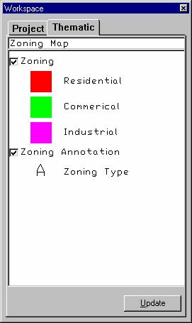
25 Brian s Thematic Map Cookbook Start a new project Attach source drawings Zoom attached drawing extents Switch to thematic workspace Add themes Save project Load and create maps Quit project without saving Demonstration Use the Thematic Wizard Create a zoning map Project Project_thmw Drawing Parcels_thmw Questions Where and how can a new theme be defined? What properties can be changed when creating a thematic map? Where are thematic maps stored?
26 Autodesk Map Coordinate Systems Section Objectives Components of a Coordinate System Working with Multiple Coordinate Systems Assigning a Global Coordinate System Mapping Issue World is Round (Spherical, Lat, Long) Maps are Flat (Planar, X, Y)
27 Definitions A datum is a reference used for surveying and mapping of the earth that serves as a basis to compute all horizontal and vertical positions. Horizontal Datums North American Datum of 1927 (NAD27) North American Datum of 1983 (NAD83) Definitions An ellipsoid is a geometric model that approximates the shape of the earth. Ellipsoid Clarke Spheroid 1866 Geodetic Reference System 80 (GRS80) Definitions A datum is the description of the horizontal & vertical locations relative to a specific location An ellipsoid is a geometric model of the earth s shape


28 Definitions A map projection is used to convert real world latitude/longitude coordinates to planar coordinates for mapping purposes Coordinate system consists of a projection, datum, ellipsoid, and local parameters Map Projections Types of Projections


29 Projection Comparison Coordinate Conversion Map Supports Source Drawings in Various Projections A Project Can Only Have a Single Coordinate System Process Assign Project Coordinate System Setup each Source Drawing Coordinate System Assign Global System
30 Example Project SP 83 UTM 11 SP 27 SP 83 UTM 12 Spatial Data Sources SD1 SD2 SD3 SD4 Considerations Assignment You cannot assign coordinate systems to any source drawings are attached and active. The drawings should be detached. The coordinate system then assigned and the drawing reattached. Coordinate system info is stored within the drawing file. Considerations Raster Objects Coordinate system transformations may not work as expected on raster objects.
31 Coordinate Conversion Behind The Scenes Map converts each source drawing to the projects coordinate system On The Fly when a query is executed On a save back the objects are converted back to the coordinate system of the attached source drawing Demonstration Convert Faults Drawing in Lat/Long WGS84 to NAD83 Calif. State Plane Zone III (feet) Open drawing Streets.dwg Set coordinate system to CA83IIIF attach drawing Fault.dwg Assign coordinate system LL84 Questions How can you permanently convert a coordinate system? What spatial properties can be distorted when using a map projection? Why do we use map projections?
32 Autodesk Map Editing Multiple Source Drawings Section Objectives List the steps involved in editing process Use the Save Back feature to save new and edited data to specific drawings Advantages and methods used in a multi-user environment File Locking Open a drawing No other users can open or attach drawing except in a read-only mode Attach a drawing (Map Only) Locks the drawing from being opened by other users by creating a file lock (.dwk dwk) Other Map users can attach, query and edit objects from the same drawing Users cannot edit the same object at the same time!!!
33 File Locking Drawing AutoCAD or Autodesk Map OPEN Autodesk Map OPEN or ATTACH Single User Autodesk Map ATTACH Drawing Autodesk Map ATTACH Multi-User Object Level Locking All queried & new objects added to the save back set are locked in their respective source drawings Object locks are removed once the save back command has been executed Editing Transaction Model Source Drawing Project Save Back Set (SBS) Query Locked Move/add SBS Unlocked Save Back
34 Query Edit Save Objects to Src Dwgs Add to Save Set no Stop Remove Locks From Objects yes Is Object Locked Error yes Object Locked By Another yes More Edits no no Lock Object in Src Dwg yes Stop Add to Save Set More Edits no Editing Operations Two Types Modify queried objects Create new objects Saving Back Two Step Procedure Add objects to the save set Save objects to source drawings
 Area (tiled) None Save Back")
35 Working With the Save Set Adding objects Modified queried objects are added by request New objects must be added by selection Save Back Options Queried Objects to Source Drawings Newly Created Objects Selective Layer (coincident) Area (tiled) None Save Back Options


36 Undo Edits Issues Map functions respect the undo & redo Edits Saved Back to source drawings cannot be undone Other Methods Remove objects from the save set Detach source drawings Quit project or Drawing maintenance Multi-User Environment Administration Setup user accounts rights Force user login & Multi-User Messages

37 Multi-User Messages Demonstration Edit Objects & Save Back to Source Drawings Single drawing edit Drawing \add stuff\edit.dwg Multi drawing edit Project \add stuff\my_project.dwg Questions Can two Autodesk Map users open the same drawing at the same time? Can two Map users that have queried the same object edit it at the same time? What happens when you add an object to the save set?
38 Review Create a project Query data and perform property alteration Convert coordinate systems Thematic Map Wizard Editing multiple source drawings Questions & Answers? Reference Materials Inside Autodesk Map 2000 (OnWord Press) Autodesk Map 5 Fundamentals Courseware (Autodesk)
39 Thank You! ftp: Name: auguest Password: guest Please fill out the evaluations Enjoy the rest of Autodesk University
1: INTRODUCTION TO AUTOCAD
 AutoCAD syllabus 1: INTRODUCTION TO AUTOCAD Starting AutoCAD AutoCAD Screen Components Drawing Area Command Window Navigation bar Status bar Invoking Commands in AutoCAD Keyboard Ribbon Application Menu
Using Map Tools within Autodesk Land Desktop to Maximize Productivity Mike Carris
 December 2-5, 2003 MGM Grand Hotel Las Vegas Using Map Tools within Autodesk Land Desktop to Maximize Productivity Mike Carris CV11-2 Autodesk civil engineering solutions include very powerful tools for
Create styles that control the display of Civil 3D objects. Copy styles from one drawing to another drawing.
 NOTES Module 03 Settings and Styles In this module, you learn about the various settings and styles that are used in AutoCAD Civil 3D. A strong understanding of these basics leads to more efficient use
Computer-Aided Design (CAD) ก ก CAD. 3 Working with drawing: ก Drawing ก Drawing ก ก Drawing Paper size Scale factor Text. Object ก Orthogonal mode ก
 ก ก CAD. 3 Working with drawing: ก Drawing ก Drawing ก ก Drawing Paper size Scale factor Text. Object ก Orthogonal mode ก") 1 ก ก ก ก ก ก ก ก ก ก CAD ก ก ก 1 ก : ก ก ก CAD ก Computer-Aided Design (CAD) ก ก CAD 2 ก : ก Installation CAD ก ก Start ก CAD ก ก Toolbar ก ก 3 Working with drawing: ก Drawing ก Drawing ก ก Drawing Paper
1 ก ก ก ก ก ก ก ก ก ก CAD ก ก ก 1 ก : ก ก ก CAD ก Computer-Aided Design (CAD) ก ก CAD 2 ก : ก Installation CAD ก ก Start ก CAD ก ก Toolbar ก ก 3 Working with drawing: ก Drawing ก Drawing ก ก Drawing Paper
AutoCAD Civil 3D 2013 South African Country Kit
 AutoCAD Civil 3D 2013 South African Country Kit Contents 1 General... 3 1.1 Introduction from the author and creator... 3 1.2 Overview... 4 2 Drawing Settings... 8 2.1 Edit Drawing Settings... 8 3 Layers...
A Practical Guide to Carlson Software Fundamentals 2015 Rick Ellis Douglas L. Aaberg, PLS Duke Gardner
 A Practical Guide to Carlson Software Fundamentals 2015 Rick Ellis Douglas L. Aaberg, PLS Duke Gardner A Cadapult Press Publication Copyright Copyright Cadapult Press, Inc. 2015 All rights reserved. No
A Practical Guide to Carlson Software Fundamentals 2018 Rick Ellis Douglas L. Aaberg, PLS Duke Gardner
 A Practical Guide to Carlson Software Fundamentals 2018 Rick Ellis Douglas L. Aaberg, PLS Duke Gardner A CADapult Press Publication Copyright Copyright CADapult Press, Inc. 2017 All rights reserved. No
Mastering AutoCAD 2D
 Course description: Mastering AutoCAD 2D Design and shape the world around you with the powerful, flexible features found in AutoCAD software, one of the world s leading 2D design applications. With robust
Dean Muccio AutoCAD Interior Designer. for the. AutoCAD for Mac and PC SDC. Better Textbooks. Lower Prices.
 Dean Muccio AutoCAD 2020 for the Interior Designer AutoCAD for Mac and PC SDC P U B L I C AT I O N S Better Textbooks. Lower Prices. www.sdcpublications.com Powered by TCPDF (www.tcpdf.org) Visit the following
Dean Muccio. AutoCAD 2018 for the. Interior Designer. AutoCAD for Mac and PC SDC. Better Textbooks. Lower Prices.
 Dean Muccio AutoCAD 2018 for the Interior Designer AutoCAD for Mac and PC SDC P U B L I C AT I O N S Better Textbooks. Lower Prices. www.sdcpublications.com Powered by TCPDF (www.tcpdf.org) Visit the following
A Practical Guide to Carlson Survey 2014
 A Practical Guide to Carlson Survey 2014 Level 1 Rick Ellis A Cadapult Press Publication Copyright Copyright Cadapult Press, Inc. 2014 All rights reserved. No part of this publication may be reproduced
Minimum Drawing & Electronic Submittal Requirements For Record Drawings /As-Builts
 Minimum Drawing & Electronic Submittal Requirements For Record Drawings /As-Builts PUBLIC WORKS ENGINEERING DEPARTMENT Revised: February 1, 2017 MINIMUM DRAWING REQUIREMENTS A. GENERAL PLAN REQUIREMENTS:
AutoCAD Tutorials. Content. Work space. Draw. Modify. Layer. Annotation. Block. Property. Utilities. Clip board. View.
 AutoCAD Tutorials Content Work space Draw Modify Layer Annotation Block Property Utilities Clip board View Insert reference Area calculation Cutting sections Plot Import and export This Tutorial is formatted
AECOsim Building Designer. Quick Start Guide. Chapter A08 Space Planning Bentley Systems, Incorporated
 AECOsim Building Designer Quick Start Guide Chapter A08 Space Planning 2012 Bentley Systems, Incorporated www.bentley.com/aecosim Table of Contents Space Planning...3 Sketches... 3 SpacePlanner... 4 Create
CAYUGA COMMUNITY COLLEGE Division of Natural and Health Sciences, Mathematics and Technology ENGR 126 Computer Aided Design 4 Credit Hours
 CAYUGA COMMUNITY COLLEGE Division of Natural and Health Sciences, Mathematics and Technology ENGR 126 Computer Aided Design 4 Credit Hours COURSE DESCRIPTION Develop basic drafting skills using microcomputer
Esri UC 2014 Technical Workshop
 Introduction to Parcel Fabric Amir Plans Parcels Control 1 Points 1-1 Line Points - Lines Editing and Maintaining Parcels using Deed Drafter and ArcGIS Desktop What is a parcel fabric? Dataset of related
Table of contents. User interface 1: Customizable tool palette... 6 User interface 2: General GUI improvements... 7
 Table of contents WELCOME TO ADVANCE CONCRETE 2014... 5 USER INTERFACE ENHANCEMENTS... 6 User interface 1: Customizable tool palette... 6 User interface 2: General GUI improvements... 7 MODELING... 10
Hydraulics and Floodplain Modeling Managing HEC-RAS Cross Sections
 v. 9.1 WMS 9.1 Tutorial Hydraulics and Floodplain Modeling Managing HEC-RAS Cross Sections Modify cross sections in an HEC-RAS model to use surveyed cross section data Objectives Build a basic HEC-RAS
Inserting and Creating ImagesChapter1:
 Inserting and Creating ImagesChapter1: Chapter 1 In this chapter, you learn to work with raster images, including inserting and managing existing images and creating new ones. By scanning paper drawings
Lecture # 7 Coordinate systems and georeferencing
 Lecture # 7 Coordinate systems and georeferencing Coordinate Systems Coordinate reference on a plane Coordinate reference on a sphere Coordinate reference on a plane Coordinates are a convenient way of
06/17/02 Page 1 of 12
 Understanding the Graphical User Interface When you start AutoCAD, the AutoCAD window opens. The window is your design work space. It contains elements that you use to create your designs and to receive
Introduction to Autodesk Inventor for F1 in Schools (Australian Version)
") Introduction to Autodesk Inventor for F1 in Schools (Australian Version) F1 in Schools race car In this course you will be introduced to Autodesk Inventor, which is the centerpiece of Autodesk s Digital
Introduction to Autodesk Inventor for F1 in Schools (Australian Version) F1 in Schools race car In this course you will be introduced to Autodesk Inventor, which is the centerpiece of Autodesk s Digital
Required Materials For complete material(s) information, refer to
 information, refer to") Butler Community College Science, Technology, Engineering, and Math Division Brett Trimpe Revised Spring 2016 Implemented Fall 2016 COURSE OUTLINE AutoCAD Basics Course Description EN 107. AutoCAD Basics.
Butler Community College Science, Technology, Engineering, and Math Division Brett Trimpe Revised Spring 2016 Implemented Fall 2016 COURSE OUTLINE AutoCAD Basics Course Description EN 107. AutoCAD Basics.
Autodesk Advance Steel. Drawing Style Manager s guide
 Autodesk Advance Steel Drawing Style Manager s guide TABLE OF CONTENTS Chapter 1 Introduction... 5 Details and Detail Views... 6 Drawing Styles... 6 Drawing Style Manager... 8 Accessing the Drawing Style
AutoCAD LT of 5
 AutoCAD LT 2010 This course explores the latest tools and techniques covering all draw commands and options, editing, dimensioning, hatching, and plotting techniques available with AutoCAD LT 2010. The
Hydraulics and Floodplain Modeling Managing HEC-RAS Cross Sections
 WMS 10.1 Tutorial Hydraulics and Floodplain Modeling Managing HEC-RAS Cross Sections Modify cross sections in an HEC-RAS model to use surveyed cross section data v. 10.1 Objectives Build a basic HEC-RAS
Tutorial Guide to AutoCAD 2015
 Tutorial Guide to AutoCAD 2015 2D Drawing, 3D Modeling Shawna Lockhart SDC P U B L I C AT I O N S For Microsoft Windows Better Textbooks. Lower Prices. www.sdcpublications.com Powered by TCPDF (www.tcpdf.org)
AutoCAD Tutorial First Level. 2D Fundamentals. Randy H. Shih SDC. Better Textbooks. Lower Prices.
 AutoCAD 2018 Tutorial First Level 2D Fundamentals Randy H. Shih SDC PUBLICATIONS Better Textbooks. Lower Prices. www.sdcpublications.com Powered by TCPDF (www.tcpdf.org) Visit the following websites to
Geometry Controls and Report
 Geometry Controls and Report 2014 InnovMetric Software Inc. All rights reserved. Reproduction in part or in whole in any way without permission from InnovMetric Software is strictly prohibited except for
COPYRIGHTED MATERIAL. The Interface
 Chapter 1 The Basics If you want to be a master in anything, you have to start with the basics. Since the Autodesk AutoCAD Civil 3D platform has evolved so much over the years, now more than ever you have
Sharing Data Between CAD and GIS Systems. Lien Alpert Phil Sanchez
 Sharing Data Between CAD and GIS Systems Lien Alpert Phil Sanchez Session Overview Discuss current CAD strategies Outline ESRI s CAD support Demonstrate techniques for working with CAD data CAD Strategies
Tutorial Guide to AutoCAD 2014
 Tutorial Guide to AutoCAD 2014 2D Drawing, 3D Modeling Shawna Lockhart SDC P U B L I C AT I O N S For Microsoft Windows Better Textbooks. Lower Prices. www.sdcpublications.com Visit the following websites
Advance Steel suite 6.1 / SP2
 Advance Steel suite 6.1 / SP2 This document describes only the improvements in Service Pack 2 compared to Service Pack 1. The installation of SP2 includes SP1; please see the previous document for improvements
Tutorial Guide to AutoCAD 2013
 Tutorial Guide to AutoCAD 2013 2D Drawing, 3D Modeling Shawna Lockhart SDC P U B L I C AT I O N S Schroff Development Corporation For Microsoft Windows Better Textbooks. Lower Prices. www.sdcpublications.com
State of Florida Department of Transportation. FDOT Traffic Plans. Signing & Pavement Markings (CE ) Signalization (CE ) Lighting
 Signalization (CE ) Lighting") State of Florida Department of Transportation FDOT Traffic Plans Signing & Pavement Markings (CE-11-0117) Signalization (CE-11-0119) Lighting (CE-11-0118) User Training Manual October 2017 PRODUCTION SUPPORT
State of Florida Department of Transportation FDOT Traffic Plans Signing & Pavement Markings (CE-11-0117) Signalization (CE-11-0119) Lighting (CE-11-0118) User Training Manual October 2017 PRODUCTION SUPPORT
Creo Parametric 4.0 Basic Design
 Creo Parametric 4.0 Basic Design Contents Table of Contents Introduction...1 Objective of This Textbook...1 Textbook Outline...2 Textbook Conventions...3 Exercise Files...3 System Configuration...4 Notes
Unit. Drawing Accurately OVERVIEW OBJECTIVES INTRODUCTION 8-1
 8-1 Unit 8 Drawing Accurately OVERVIEW When you attempt to pick points on the screen, you may have difficulty locating an exact position without some type of help. Typing the point coordinates is one method.
User Guide V10 SP1 Addendum
 Alibre Design User Guide V10 SP1 Addendum Copyrights Information in this document is subject to change without notice. The software described in this document is furnished under a license agreement or
DRAFT Solid Edge ST4 Update Training Draft
 DRAFT Solid Edge ST4 Update Training Draft Presented by: Steve Webb Topics Parts List Table Titles Column Headers Headers Merging Header Rotate Cell Aspect Ratio Cell Formatting Overriding Disabled Cells
Advance Steel. Drawing Style Manager s guide
 Advance Steel Drawing Style Manager s guide TABLE OF CONTENTS Chapter 1 Introduction...7 Details and Detail Views...8 Drawing Styles...8 Drawing Style Manager...9 Accessing the Drawing Style Manager...9
Generative Drafting Overview What's New Getting Started User Tasks
 Generative Drafting Overview Conventions What's New Getting Started Defining the Drawing Sheet Part Drawing Opening a Part Creating a Front View Creating a Projection View Creating a Section View Creating
Type A. BWSC CAD Standards for Site Plans (Design and As-Built) Format. Scale. Fonts, Linetypes, Shapes
 Format. Scale. Fonts, Linetypes, Shapes") BWSC CAD Standards for Site Plans (Design and As-Built) Type A The following CAD standards are for Type A application and involve no work in Public Street, except for connection(s) to the Boston Water
BWSC CAD Standards for Site Plans (Design and As-Built) Type A The following CAD standards are for Type A application and involve no work in Public Street, except for connection(s) to the Boston Water
AGENDA. Effective Geodatabase Management. Presentation Title. Using Automation. Mohsen Kamal. Name of Speaker Company Name
 AGENDA Effective Geodatabase Management Presentation Title Using Automation Mohsen Kamal Name of Speaker Company Name Agenda Introducing the geodatabase What is a Schema? Schema Creation Options Geoprocessing
SDC. AutoCAD LT 2007 Tutorial. Randy H. Shih. Schroff Development Corporation Oregon Institute of Technology
 AutoCAD LT 2007 Tutorial Randy H. Shih Oregon Institute of Technology SDC PUBLICATIONS Schroff Development Corporation www.schroff.com www.schroff-europe.com AutoCAD LT 2007 Tutorial 1-1 Lesson 1 Geometric
ACAD-BAU TUTORIAL For BricsCAD platform
 ACAD-BAU TUTORIAL WWW.ARHINOVA.SI For BricsCAD platform August 06 WORKSPACE ACAD-BAU RIBBON ACAD-BAU CONTROL BAR F ACAD-BAU PALETTES BASIC SETTINGS Use New command and open the template called ACB_International.DWT.
Using Dynamic Views. Module Overview. Module Prerequisites. Module Objectives
 Using Dynamic Views Module Overview The term dynamic views refers to a method of composing drawings that is a new approach to managing projects. Dynamic views can help you to: automate sheet creation;
EDUCATION GIS CONFERENCE Geoprocessing with ArcGIS Pro. Rudy Prosser GISP CTT+ Instructor, Esri
 EDUCATION GIS CONFERENCE Geoprocessing with ArcGIS Pro Rudy Prosser GISP CTT+ Instructor, Esri Maintenance What is geoprocessing? Geoprocessing is - a framework and set of tools for processing geographic
Working With Drawing Views-I
 Chapter 12 Working With Drawing Views-I Learning Objectives After completing this chapter you will be able to: Generate standard three views. Generate Named Views. Generate Relative Views. Generate Predefined
Quick Guide for ArcReader GIS Installation & Use
 Town of Hanover Planning Department Quick Guide for ArcReader GIS Installation & Use For more information, contact the Town Planner, Andrew Port (781-826-7641) or port.planning@hanover-ma.gov System Requirements
Drawing Management Brain Dump
 Drawing Management Brain Dump Paul McArdle Autodesk, Inc. April 11, 2003 This brain dump is intended to shed some light on the high level design philosophy behind the Drawing Management feature and how
Subdivision Cross Sections and Quantities
 NOTES Module 11 Subdivision Cross Sections and Quantities Quantity calculation and cross section generation are required elements of subdivision design projects. After the design is completed and approved
Montana Association of Registered Land Surveyors Conference 2013
 AutoCAD CIVIL 3D Survey Features - Field to Finish This session is an introduction to the Civil 3D Survey Tools. We will cover some basics of working with Survey Databases and Automated Linework. We will
ArcGIS Tutorial: Geocoding Addresses
 U ArcGIS Tutorial: Geocoding Addresses Introduction Address data can be applied to a variety of research questions using GIS. Once imported into a GIS, you can spatially display the address locations and
How to Design and Submit a DOT Project with Civil 3D
 11/30/2006-5:00 pm - 6:30 pm Room:San Polo - 3503 (ISD Campus) How to Design and Submit a DOT Project with Civil 3D Seth Cohen - ProSoft NET CV35-2 This lab will delve into the workflows and processes
What is a Survey? The site plan is usually based on an professional land survey.
 Site Plan: Illustrates the existing natural and built features of a site and describes proposed construction in relation to the existing features. The site plan is essential for studying the influence
Introduction to IntelliCAD 6
 Introduction to IntelliCAD 6 These notes explain the basic concepts and techniques for doing 2D line drawings, with dimensions, arranged onto sheets for printing, using the 6.4 or 6.6 versions of IntelliCAD
1.1 GENERAL RECORD DRAWING REQUIREMENTS
 Page 1 of 5 VILLAGE OF ROMEOVILLE RECORD DRAWINGS CHECKLIST PART I GENERAL Record drawings are required to provide a means of schematic verification that the intent of the approved engineering design has
Tools for Design. with VEX Robot Kit: Randy H. Shih Oregon Institute of Technology SDC PUBLICATIONS
 Tools for Design with VEX Robot Kit: AutoCAD 2011 and Autodesk Inventor 2011 2D Drawing 3D Modeling Hand Sketching Randy H. Shih Oregon Institute of Technology INSIDE: SUPPLEMENTAL FILES ON CD SDC PUBLICATIONS
Rhinoceros modeling tools for designers. Using Layouts in Rhino 5
 Rhinoceros modeling tools for designers Using Layouts in Rhino 5 RH50-TM-LAY-Apr-2014 Rhinoceros v5.0, Layouts, Training Manual Revised April 8, 2014, Mary Fugier mary@mcneel.com Q&A April 8, 2014, Lambertus
Modeling an Airframe Tutorial
 EAA SOLIDWORKS University p 1/11 Difficulty: Intermediate Time: 1 hour As an Intermediate Tutorial, it is assumed that you have completed the Quick Start Tutorial and know how to sketch in 2D and 3D. If
Getting Started. Before You Begin, make sure you customized the following settings:
 Getting Started Getting Started Before getting into the detailed instructions for using Generative Drafting, the following tutorial aims at giving you a feel of what you can do with the product. It provides
An Introduction to Autodesk Inventor 2011 and AutoCAD Randy H. Shih SDC PUBLICATIONS. Schroff Development Corporation
 An Introduction to Autodesk Inventor 2011 and AutoCAD 2011 Randy H. Shih SDC PUBLICATIONS www.sdcpublications.com Schroff Development Corporation An Introduction to Autodesk Inventor 2011 and AutoCAD 2011
AutoCAD. Map 3D Learning AutoCAD. Essentials. Map 3D Autodesk Official Training Guide
 Autodesk Official Training Guide Essentials AutoCAD Map 3D 2010 Learning AutoCAD Map 3D 2010 Using hands-on exercises, learn how to create, manage, edit, and analyze mapping geospatial data. 129B1-050000-CM00A
COLLEGE OF DUPAGE Architecture Basic CADD-AutoCAD
 COLLEGE OF DUPAGE Architecture 1211 - Basic CADD-AutoCAD Mark Pearson COD Main #: 630.942.2763 Mailbox location: TEC 1061 Office Hours: TEC 1050 M,W: 11am-12:30pm T, R: 4:00pm-6pm E-Mail: pearson@cod.edu
Advance Concrete. Tutorial
 Advance Concrete Tutorial Table of contents About this tutorial... 9 How to use this guide... 10 Lesson 1: Creating a building grid... 11 Step 1: Create a default building grid... 11 Step 2: Set the distances
ExtrAXION. Extracting Drawing data. Benefits.
 ExtrAXION Extracting Drawing data ExtrAXION is the simplest and most complete quantity takeoff software tool for construction plans. It has the ability to measure on vector files CAD (dwg, dxf, dgn, emf,
ARCHICAD Introduction Tutorial
 Starting a New Project ARCHICAD Introduction Tutorial 1. Double-click the Archicad Icon from the desktop 2. Click on the Grey Warning/Information box when it appears on the screen. 3. Click on the Create
Appendix to Chapter 1 Release 3
 Appendix to Chapter 1 Release 3 Introduction to AutoCAD Architectural Desktop Release 3 Enhancements to AutoCAD Architectural Desktop Release 3 include changes in the content of the menu bar, toolbars,
Smart 3D Plant/Outfitting Curriculum Path & Training Guidelines
 Smart 3D Plant/Outfitting Curriculum Path & Training Guidelines Intergraph PPM recommends that new Smart 3D plant/outfitting users select one of the following training tracks described below. 1. System
From Raster to Vector: Make That Scanner Earn Its Keep!
 December 2-5, 2003 MGM Grand Hotel Las Vegas From Raster to Vector: Make That Scanner Earn Its Keep! Felicia Provencal GD31-2 This class is an in-depth introduction to Autodesk Raster Design, formerly
AutoCAD 2014 Tutorial - First Level: 2D Fundamentals
 AutoCAD 2014 Tutorial - First Level: 2D Fundamentals Randy H. Shih Multimedia Disc SDC PUBLICATIONS Schroff Development Corporation Better Textbooks. Lower Prices. www.sdcpublications.com Video presentations
Introduction to Polylines and Multilines Chapter 15
 Introduction to Polylines and Multilines Chapter 15 Sacramento City College EDT 310 Chapter 15 - Introduction to Polylines and Multilines 1 Polylines Chapter 15 - Introduction to Polylines and Multilines
Chapter 2. Drawing Sketches for Solid Models. Learning Objectives
 Chapter 2 Drawing Sketches for Solid Models Learning Objectives After completing this chapter, you will be able to: Start a new template file to draw sketches. Set up the sketching environment. Use various
Required Materials: Textbook: Grabowski, R. (2004). Using AutoCAD 2004: Basics. Clifton Park, N.Y: Delmar Learning.
. Using AutoCAD 2004: Basics. Clifton Park, N.Y: Delmar Learning.") Butler Community College Business, Technology, and Workforce Development COURSE OUTLINE AutoCAD Basics Mel Whiteside Spring 2004 Course Description: EN107. AutoCAD Basics. 3 hours credit. This course will
Butler Community College Business, Technology, and Workforce Development COURSE OUTLINE AutoCAD Basics Mel Whiteside Spring 2004 Course Description: EN107. AutoCAD Basics. 3 hours credit. This course will
AutoCAD 2D. Table of Contents. Lesson 1 Getting Started
 AutoCAD 2D Lesson 1 Getting Started Pre-reqs/Technical Skills Basic computer use Expectations Read lesson material Implement steps in software while reading through lesson material Complete quiz on Blackboard
Cricut Design Space App for ipad User Manual
 Cricut Design Space App for ipad User Manual Cricut Explore design-and-cut system From inspiration to creation in just a few taps! Cricut Design Space App for ipad 1. ipad Setup A. Setting up the app B.
AutoCAD LT 2012 Tutorial. Randy H. Shih Oregon Institute of Technology SDC PUBLICATIONS. Schroff Development Corporation
 AutoCAD LT 2012 Tutorial Randy H. Shih Oregon Institute of Technology SDC PUBLICATIONS www.sdcpublications.com Schroff Development Corporation AutoCAD LT 2012 Tutorial 1-1 Lesson 1 Geometric Construction
A Quick Spin on Autodesk Revit Building
 11/28/2005-3:00 pm - 4:30 pm Room:Americas Seminar [Lab] (Dolphin) Walt Disney World Swan and Dolphin Resort Orlando, Florida A Quick Spin on Autodesk Revit Building Amy Fietkau - Autodesk and John Jansen;
Part I Introduction to CorelCAD
 Table of Contents Part I Introduction to CorelCAD 1 Introducing CorelCAD for Mac... 3 About CorelCAD... 3 Benefits of Using CorelCAD....4 Impressive Compatibility... 4 Familiar User Interface.... 4 Drafting
Table of Contents. Lesson 1 Getting Started
 NX Lesson 1 Getting Started Pre-reqs/Technical Skills Basic computer use Expectations Read lesson material Implement steps in software while reading through lesson material Complete quiz on Blackboard
Design of Roundabouts using Corridor Models (Part 1 of 2)
") AUTODESK CIVIL3D Design of Roundabouts using Corridor Models (Part 1 of 2) Dynamic vertical modeling By Jack Strongitharm Civil 3D Technical Sales Manager UK and Ireland jack.strongitharm@autodesk.com
AUTODESK CIVIL3D Design of Roundabouts using Corridor Models (Part 1 of 2) Dynamic vertical modeling By Jack Strongitharm Civil 3D Technical Sales Manager UK and Ireland jack.strongitharm@autodesk.com
Getting Started with. Vectorworks Architect
 Getting Started with Vectorworks Architect Table of Contents Introduction...2 Section 1: Program Installation and Setup...6 Installing the Vectorworks Architect Program...6 Exercise 1: Launching the Program
ILLUSTRATOR BASICS FOR SCULPTURE STUDENTS. Vector Drawing for Planning, Patterns, CNC Milling, Laser Cutting, etc.
 ILLUSTRATOR BASICS FOR SCULPTURE STUDENTS Vector Drawing for Planning, Patterns, CNC Milling, Laser Cutting, etc. WELCOME TO THE ILLUSTRATOR TUTORIAL FOR SCULPTURE DUMMIES! This tutorial sets you up for
CADD & Civil 3D User Guidelines
 THURSTON COUNTY PUBLIC WORKS DEPARTMENT Design and Construction Division CADD & Civil 3D User Guidelines V4.0_06_10_15 1 THURSTON COUNTY PUBLIC WORKS DEPARTMENT DESIGN AND CONSTRUCTION DIVISION CADD &
Existing and Design Profiles
 NOTES Module 09 Existing and Design Profiles In this module, you learn how to work with profiles in AutoCAD Civil 3D. You create and modify profiles and profile views, edit profile geometry, and use styles
SETTING UP YOUR PAGE LAYOUT:
 In this workshop we will look at: Setting up your drawing sheet Viewports Printing your work Once you ve drawn your work in the Model space and you re ready to print, you need to set up your Drawing Sheet
Creo Parametric 2.0: Introduction to Solid Modeling. Creo Parametric 2.0: Introduction to Solid Modeling
 Creo Parametric 2.0: Introduction to Solid Modeling 1 2 Part 1 Class Files... xiii Chapter 1 Introduction to Creo Parametric... 1-1 1.1 Solid Modeling... 1-4 1.2 Creo Parametric Fundamentals... 1-6 Feature-Based...
Exercise 1: The AutoCAD Civil 3D Environment
 Exercise 1: The AutoCAD Civil 3D Environment AutoCAD Civil 3D Interface Object Base Layer Object Component Layers 1-1 Introduction to Commercial Site Grading Plans AutoCAD Civil 3D Interface AutoCAD Civil
Table of Contents. Part I Introduction to CorelCAD Introducing CorelCAD About CorelCAD Benefits of Using CorelCAD...
 Table of Contents Part I Introduction to C 2013.... 1 1 Introducing C 2013.... 3 About C... 4 Benefits of Using C....4 Impressive Compatibility... 4 Familiar User Interface.... 5 Drafting Tools.... 5 Collaboration....
Miami University. Physical Facilities Department. CAD Standards. April 2004
 Miami University Physical Facilities Department CAD Standards April 2004 1.0.0 OVERVIEW These standards pertain to the use, production and submittal of electronic CAD files at Miami University. They have
DIGITAL DATA SUBMISSION STANDARDS Procedures and Guidelines
 DIGITAL DATA SUBMISSION STANDARDS Procedures and Guidelines 2014 Citizens Wastewater of Westfield - GIS Digital Standards Table of Contents Introduction... 3 Definitions and Terms... 3 Reference Documents...
Tutorial 3: Drawing Objects in AutoCAD 2011
 Tutorial 3: Drawing Objects in AutoCAD 2011 Audience: Users new to AutoCAD Prerequisites: None Time to complete: 15 minutes In This Tutorial Please complete the lessons in this tutorial in order. The earlier
AutoCAD Civil 3D Fundamentals
 AutoCAD Civil 3D Fundamentals Course Length: 4 days The AutoCAD Civil 3D Fundamentals training course is designed for Civil Engineers and Surveyors who want to take advantage of the AutoCAD Civil 3D software
AECOsim Building Designer. Quick Start Guide. Chapter 2 Making the Mass Model Intelligent Bentley Systems, Incorporated.
 AECOsim Building Designer Quick Start Guide Chapter 2 Making the Mass Model Intelligent 2012 Bentley Systems, Incorporated www.bentley.com/aecosim Table of Contents Making the Mass Model Intelligent...3
HYDROGRAPHIC SURVEY STANDARDS AND DELIVERABLES
 TABLE OF CONTENTS 1. HYDROGRAPHIC SURVEY METHODOLOGY... 3 2. HYDROGRAPHIC SURVEY REFERENCE STANDARDS... 3 3. HYDROGRAPHIC SURVEY CRITERIA... 3 3.1 HYDROGRAPHIC SURVEYS OVER NON GAZETTED NAVIGABLE WATERS*:...
Zooming in on Architectural Desktop Layouts Alexander L. Wood
 December 2-5, 2003 MGM Grand Hotel Las Vegas Alexander L. Wood Code BD41-3L Take advantage of both AutoCAD and Autodesk Architectural Desktop Layout features. We'll look at the basics of setting up AutoCAD
Introduction to AutoCAD 2012
 Page 1 Introduction to AutoCAD 2012 Alf Yarwood Answers to Multiple choice questions Chapter 1 1. The toolbar at the top of the AutoCAD 2012 window is: (a) The Draw toolbar (b) The Modify toolbar (c) The
AutoCAD Lab 1 Basics and Drawing Fundamentals. EGS 1007 Engineering Concepts and Methods
 AutoCAD Lab 1 Basics and Drawing Fundamentals EGS 1007 Engineering Concepts and Methods Will the Computer Ever REPLACE Pencil and Paper Drawings? Maybe someday When a computer becomes as light, small,
Introduction to CATIA V5
 Introduction to CATIA V5 Release 17 (A Hands-On Tutorial Approach) Kirstie Plantenberg University of Detroit Mercy SDC PUBLICATIONS Schroff Development Corporation www.schroff.com Better Textbooks. Lower
Sheet Metal OverviewChapter1:
 Sheet Metal OverviewChapter1: Chapter 1 This chapter describes the terminology, design methods, and fundamental tools used in the design of sheet metal parts. Building upon these foundational elements