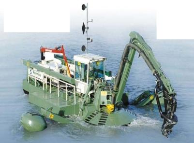
Innovations in Marine & Dredging Engineering. 3D GNSS Depth Monitoring System. pcx-pro
|
|
|
- Isaac Brent Carr
- 5 years ago
- Views:
Transcription

1 Innovations in Marine & Dredging Engineering 3D GNSS Depth Monitoring System pcx-pro

2 Prolec - 30 Years of Achievement 1 st Supplier of Can Bus Products 1 st Graphical SLI 1 st Excavator Graphical Depth Monitor 1 st 3D Excavator RTK Machine Guidance


3 Prolec MCo Philosophy OPA - Open Architecture GPS/GNSS Compatibility Multiple 3D File Formats Operator Focus User friendly GUI Intuitive Operation Minimal Training Cost of Ownership Low Maintenance Optimized Product Range Application Specific Installation


4 Sensors Key to Accuracy 1 High accurate Solid State AS8 Angle Sensors CANBUS 2.0B, magnetically damped Accuracy: 0,09 IP68 full submersible stainless steel version High accurate Solid State AS9 D/Drive Sensor CANBUS 2.0B, direct driven Accuracy: 0,09 IP68 full submersible stainless steel version


5 Sensors Key to Accuracy 2 Solid State AS7 Angle Sensor for bucket CANBUS 2.0B Technology Accuracy: 0,2 IP68 full submersible stainless steel version with additional protection mounting shoe Hydraulic Flowmeter for special applications Two possible flow rates OMH52/68


6 Sensors Key to Accuracy 3 Slew Option 1 for monitoring slew of machine relative to pontoon / barge Non-wearing monitoring by proximity switches counting teeth of slew ring and CAN Quad Sensor Slew Option 2 for monitoring slew of machine relative to pontoon / barge Monitoring by 50ppr slew wheel encoder and CAN Quad Sensor

7 Sensors The Near Future Dual Redundant Triple Axis Sensors for integration of Machine Guidance and Machine Safety in one seamless solution (also according to machinery directive 2006/42 EC, EN474-5:2006 and EN 13000/13849)

8 pcx-pro - The Software Operating system based on familiar Windows XP Easy to operate intuitive menu structure Material simulation Footprint Max working radius Bucket Guidance line Favourites on main screen Markers


9 pcx-pro The Software Twodimensinal side view shows target depths, profile and position of machine Threedimensional view shows machine and Digital Terrain Model (DTM) in free selectable direction. Including progress map updated in realtime

10 pcx-pro The Software Top view showing actual versus target progress in realtime. Progress coloured according to target current surface changes Top-Down Perspective Complete Site View 2D Overlays

11 pcx-pro The Software Tool configurations Buckets / Shovels Clamshell / Grab Milling head Hammer Driller Suctions / Pumps Vacuum Clay Layer Sand Mat Layer


12 pcx-pro The Software Special tool configuration Sand Mat Layer


13 pcx-pro The Software Special machine configuration Watermaster


14 pcx-pro The Software Special machine configuration Flap barges / dumping frames including wireless VGA transfer for positioning inside model by towboat


15 pcx-pro The Software Special machine configuration Cable crane / Grab Dredger payout of rope and open/close grab is monitored on drums


16 pcx-pro The Software Special machine configuration Special kinematics Drifting of grab under water effected by water flow is monitored by additional dual axis sensor


17 pcx-pro The Software Special machine configuration Water jetting / Vacuum pump
18 pcx-pro The Software Taking it to the extreme unique.


19 pcx-pro The Software Geocean. Full remotely underwater operated diving excavator


20 pcx-pro The Software The integrated Job Viewer gives an output of the progress map in the following versions: Elevation Psychedelic Elevation Thermal Grey Scale Progress Map


21 pcx-pro The Software Including ProJob Software for data conversion and as Analysis Productivity Module


22 pcx-pro - The Software Additional Applications - Shadow Mode Radio controlled transmission of all relevant CANbus data to second PC to give free selectable views and realtime update of progress map for use by job supervisor
23 pcx-pro - The Software Additional Applications - Remote Service Support Full access to pcx-pro software and GNSS receiver Worldwide remoteless service support Complete control of machine based PC Online Operator Training Data Transfer (new jobs, software updated) from and to machine


24 Sensors Key to Accuracy 4 presented by Michael Schulz

511-30399-66 @:")

25 Am Hohen Ufer 3A Hannover : +49 (0) : +49 info@allsat.de MCG 2012, Michael Schulz


26 Portfolio GNSS and TPS Solutions for Positioning and Navigation Services Global Monitoring Survey Software Reference Network Services for Satellite Navigation Complete Solutions for Positioning and Navigation MCG 2012, Michael Schulz

")


27 ALLSAT Development Software GART-2000 gl-survey (ArcGIS Survey-Extension) ALLTRANS (Coordinate Transformation) System integration Individual Software Developments Customer oriented adaption of software products Hardware (e.g. Communication Modules) come2ascos ALLSAT Virtual Base MCG 2012, Michael Schulz

28 ALLSAT - JAVAD GNSS Premium Sales Partner MCG 2012, Michael Schulz Survey Instruments


29 A short history from Javad Ashjaee: In 1983 I co-pioneered high precision GPS at Trimble, introducing the four-channel Trimble 4000-S geodetic receiver. I single-handedly wrote its complete software. It was the first commercial GPS geodetic receiver and it changed the geodetic survey industry. I founded Ashtech and in 1989 we introduced the first All-in- One, All-in-View 12-channel Ashtech L-12 GPS receiver, followed by Ashtech Z-12. These were the first truly portable geodetic receivers. We were also the first to integrate GPS and GLONASS satellites. In 1998 I founded Javad Positioning Systems and introduced Legacy, Odyssey, and Regency GNSS geodetic products, followed by the 76-channel Prego and HiPer receivers. Other companies later copied HiPer. Today many GNSS receivers look like it. In 2007 I founded JAVAD GNSS and introduced the 216- channel TRIUMPH product and its OEM versions ALPHA, DELTA and SIGMA. We are again the first to commercially offer receivers which track current and future Galileo Satellites. MCG 2012, Michael Schulz

30 Hardware Highlights: - Completely Integrated Solution Channels - GPS + GLONASS + Galileo - Supports Network RTK RTCM 3.x with VRS/MAC - Integrated GSM + UHF communication - Internal Batteries for up to 15 hours of operation MCG 2012, Michael Schulz

31 Hardware MCG 2012, Michael Schulz

32 Standard Setup for Machine Guidance x y z y x z - Precise RTK position with up to 100Hz output rate - Attitude output (e.g. Heading for 2 antenna system) - Seamless integration of Network RTK corrections MCG 2012, Michael Schulz
33 Advanced Setup for Machine Guidance x y n =y x y z z n z x n - Precise RTK position - Attitude output (Pitch, Roll and Heading for 4 antenna system) - Integration of IMU data (3 translations, 3 rotations) - Seamless integration of Network RTK corrections MCG 2012, Michael Schulz


34 New Filter MCG 2012, Michael Schulz

35 Thank you for your attention MCG 2012, Michael Schulz
Inertial Sensors. Ellipse 2 Series MINIATURE HIGH PERFORMANCE. Navigation, Motion & Heave Sensing IMU AHRS MRU INS VG
 Ellipse 2 Series MINIATURE HIGH PERFORMANCE Inertial Sensors IMU AHRS MRU INS VG ITAR Free 0.1 RMS Navigation, Motion & Heave Sensing ELLIPSE SERIES sets up new standard for miniature and cost-effective
CHC MINING DEFORMATION MONITORING SOLUTION
 CHC MINING DEFORMATION MONITORING SOLUTION Safety is first in mining. CHC offers solutions designed to improve safety for personnel on the ground and in the cab with 24/7 precision positioning for automatic
Inertial Sensors. Ellipse Series MINIATURE HIGH PERFORMANCE. Navigation, Motion & Heave Sensing IMU AHRS MRU INS VG
 Ellipse Series MINIATURE HIGH PERFORMANCE Inertial Sensors IMU AHRS MRU INS VG ITAR Free 0.1 RMS Navigation, Motion & Heave Sensing ELLIPSE SERIES sets up new standard for miniature and cost-effective
Inertial Sensors. Ellipse 2 Series MINIATURE HIGH PERFORMANCE. Navigation, Motion & Heave Sensing IMU AHRS MRU INS VG
 Ellipse 2 Series MINIATURE HIGH PERFORMANCE Inertial Sensors IMU AHRS MRU INS VG ITAR Free 0.1 RMS Navigation, Motion & Heave Sensing ELLIPSE SERIES sets up new standard for miniature and cost-effective
Motion & Navigation Solution
 Navsight Land & Air Solution Motion & Navigation Solution FOR SURVEYING APPLICATIONS Motion, Navigation, and Geo-referencing NAVSIGHT LAND/AIR SOLUTION is a full high performance inertial navigation solution
GPS-Aided INS Datasheet Rev. 3.0
 1 GPS-Aided INS The Inertial Labs Single and Dual Antenna GPS-Aided Inertial Navigation System INS is new generation of fully-integrated, combined GPS, GLONASS, GALILEO, QZSS, BEIDOU and L-Band navigation
670 10/26/17 SSD: 07/14/16, 09/16/17 Page 1 of 6
 SSD: 07/14/16, 09/16/17 Page 1 of 6 S P E C I A L P R O V I S I O N Section MISCELLANEOUS INCIDENTALS Item.822 - GNSS Construction Inspection Equipment Description SAMPLE PROJECT 12345 10/30/17 1.1 Work
WATER CONSERVATION AND LANDFORMING
 WATER CONSERVATION AND LANDFORMING 2 LANDFORMING INDUSTRY LEADING LANDFORMING Proven survey, field design and landforming with GNSS accuracy. Topcon offers dual-constellation (GPS + GLONASS) satellite
Indian Institute of Technology Kanpur Department of Civil Engineering
 Indian Institute of Technology Kanpur Department of Civil Engineering Inquiry No- CE/JNM/2013-14/R-10 30 December, 2013 Subject: Quotation for supply of Integrated System/Smart System Reflectorless Robotic
Inertial Navigation System
 Apogee Series ULTIMATE ACCURACY MEMS Inertial Navigation System INS MRU AHRS ITAR Free 0.005 RMS Motion Sensing & Georeferencing APOGEE SERIES makes high accuracy affordable for all surveying companies.
icon gps 80 Hint Sheet
 icon gps 80 Hint Sheet Date 17 th March 2014 From Lennon Bedford, Product Specialist GNSS Sensors, Leica Machine Control Valentin Fuchs, Program Manager, Leica Machine Control Upgrading existing Redline
GE 113 REMOTE SENSING
 GE 113 REMOTE SENSING Topic 9. Introduction to Global Positioning Systems (GPS) and Other GNSS Technologies Lecturer: Engr. Jojene R. Santillan jrsantillan@carsu.edu.ph Division of Geodetic Engineering
GPS-Aided INS Datasheet Rev. 2.7
 1 The Inertial Labs Single and Dual Antenna GPS-Aided Inertial Navigation System INS is new generation of fully-integrated, combined GPS, GLONASS, GALILEO, QZSS and BEIDOU navigation and highperformance
Guide to GNSS Base stations
 Guide to GNSS Base stations Outline Introduction Example of a base station (TUMSAT) Preparation for setting up a base station Procedure for setting up a base station Examples at two other universities
GeoMax GNSS Zenith10 & Zenith20 Series
 GeoMax GNSS Zenith10 & Zenith20 Series GeoMax About Us At GeoMax we provide a com- group with strong market At GeoMax, we concentrate on prehensive portfolio of inte- positions within measurement providing
boost productivity. stay on GrADe. CAt ACCuGrADe
 boost productivity. Stay on grade. Cat AccuGrade Work smarter by getting it right, the first time, with advanced machine control and guidance solutions to help you boost your productivity and your bottom
Crawler Tractors PR 714 PR 764. Product information. Grade control systems
 Crawler Tractors PR 714 PR 764 Product information Grade control systems Grade Control Systems for Crawler Tractors To be successful in spite of ever-increasing time and cost pressures, construction machinery
CAESultra for Mining. Machine Compatibility. Shovels, Motor Graders, Hydraulic Excavators, Track-Type Tractors
 CAESultra for Mining Machine Compatibility Machine Family Scrapers, Loaders, Dozers, Shovels, Motor Graders, Hydraulic Excavators, Track-Type Tractors CAESultra for Mining CAESultra for Mining is a versatile
ENHANCEMENTS IN UAV FLIGHT CONTROL AND SENSOR ORIENTATION
 Heinz Jürgen Przybilla Manfred Bäumker, Alexander Zurhorst ENHANCEMENTS IN UAV FLIGHT CONTROL AND SENSOR ORIENTATION Content Introduction Precise Positioning GNSS sensors and software Inertial and augmentation
Inertial Systems. Ekinox Series TACTICAL GRADE MEMS. Motion Sensing & Navigation IMU AHRS MRU INS VG
 Ekinox Series TACTICAL GRADE MEMS Inertial Systems IMU AHRS MRU INS VG ITAR Free 0.05 RMS Motion Sensing & Navigation AEROSPACE GROUND MARINE EKINOX SERIES R&D specialists usually compromise between high
Leica GPS900 Equipment List
 Leica GPS900 Equipment List 2 GPS900 Package 1. GPS900 RTK Rover 1.1 GPS900 Controller The controller can be connected to the ATX900 with a Bluetooth connection or can be connected using a cable. 1.1.1
TRIUMPH TECHNOLOGY. Javad Ashjaee
 TRIUMPH TECHNOLOGY Javad Ashjaee JAVAD GNSS www.javad.com International SatelliteNavigation Forum Moscow, April 7, 2008 TRIUMPH WE ARE BACK TO LEAD With TRIUMPH! 2 TRIUMPH Technology At the heart of our
Inertial Sensors. Ellipse Series MINIATURE HIGH PERFORMANCE. Navigation, Motion & Heave Sensing IMU AHRS MRU INS VG
 Ellipse Series MINIATURE HIGH PERFORMANCE Inertial Sensors IMU AHRS MRU INS VG ITAR Free 0.2 RMS Navigation, Motion & Heave Sensing ELLIPSE SERIES sets up new standard for miniature and cost-effective
Chapter 2 Definitions and Acronyms
 Advanced Materials and Technology Manual TABLE OF CONTENTS.0 Introduction... 1.1 Definitions... FIGURE.1 Schematic of Gridded All Passes Data and Gridded Final Coverage Data.... 4 FIGURE. Schematic of
Opera Duo. GeoRadar Division
 Utilities Detection and Mapping Opera Duo: real-time detection of pipes RIS MF Hi-Mod: Utilities mapping on all zones All rights reserved to IDS 2 Utilities Detection and Mapping Stream: massive arrays
Specifications. Trimble BX982 Modular GNSS Heading Receiver
 Name Configuration Option Base and Rover interchangeability Rover position update rate Rover maximum range from base radio Rover operation within a VRS network Heading and Moving Base operation Factory
Sokkia GNSS Receiver. Product Portfolio. Price GRX2 GCX2. GHX2 MESA Field Tablet SA300 S-10. Features
 Only from Sokkia GNSS Receiver Price Product Portfolio GRX2 GCX2 S-10 GHX2 MESA Field Tablet SA300 Features Product Overview Smallest and lightest GNSS integrated receiver Innovative and ergonomic shape
Trimble GNSS Infrastructure
 Trimble GNSS Infrastructure A History of Innovation Trimble, the first company to offer commercial GPS products company to integrate GPS with communications technology RTK system in the market in 1994
GNSS CONSTRUCTION INSPECTION EQUIPMENT
 Project: Jamaica-Winhall STP 2904(1) Advertised Date: 5/30/2018 GNSS CONSTRUCTION INSPECTION EQUIPMENT DESCRIPTION. This work shall consist of furnishing, configuring, installing, maintaining, and removing
GPS-Aided INS Datasheet Rev. 2.6
 GPS-Aided INS 1 GPS-Aided INS The Inertial Labs Single and Dual Antenna GPS-Aided Inertial Navigation System INS is new generation of fully-integrated, combined GPS, GLONASS, GALILEO and BEIDOU navigation
Specifications. Trimble SPS555H Heading Add-on Receiver
 Receiver Name Configuration Option Base and Rover interchangeability Rover position update rate Rover maximum range from base radio Rover operation within a VRS network Heading and Moving Base operation
al T TD ) ime D Faamily Products The RTD Family of products offers a full suite of highprecision GPS sensor positioning and navigation solutions for:
 ime D Faamily Products The RTD Family of products offers a full suite of highprecision GPS sensor positioning and navigation solutions for:") Reeal ynnamics al T amics (R TD ) ime D RTD) Time Dy Faamily mily ooff P roducts Products The RTD Family of products offers a full suite of highprecision GPS sensor positioning and navigation solutions
Reeal ynnamics al T amics (R TD ) ime D RTD) Time Dy Faamily mily ooff P roducts Products The RTD Family of products offers a full suite of highprecision GPS sensor positioning and navigation solutions
Opportunities and Limitations of Automatic Steering Technologies. Nyle Wollenhaupt Advanced Technology Solutions Agronomist
 Opportunities and Limitations of Automatic Steering Technologies Nyle Wollenhaupt Advanced Technology Solutions Agronomist So where do we start? We start at the beginning. When we didn t have GPS-assisted
Inertial Navigation System
 Apogee Marine Series ULTIMATE ACCURACY MEMS Inertial Navigation System INS MRU AHRS ITAR Free 0.005 RMS Navigation, Motion & Heave Sensing APOGEE SERIES makes high accuracy affordable for all surveying
GS030. Crane Slew-Angle Wireless Measurement Sensor. Features. Application
 Features Crane Slew-Angle Wireless Measurement Sensor Resolution of 0.1 Accuracy: typical: 0.5 over 360 Range: 0 to 360 Rugged water proof enclosure IP66 Potted electronics for increased water protection
Leica GRX1200+ Series High Performance GNSS Reference Receivers
 Leica GRX1200+ Series High Performance GNSS Reference Receivers Leica GRX1200+ Series For permanent reference stations The Leica GRX1200+ Series, part of Leica's future proof System 1200, is designed specifically
ATLANS-C. mobile mapping position and orientation solution
 mobile mapping position and orientation solution mobile mapping position and orientation solution THE SMALLEST ATLANS-C is a high performance all-in-one position and orientation solution for both land
NovAtel s. Performance Analysis October Abstract. SPAN on OEM6. SPAN on OEM6. Enhancements
 NovAtel s SPAN on OEM6 Performance Analysis October 2012 Abstract SPAN, NovAtel s GNSS/INS solution, is now available on the OEM6 receiver platform. In addition to rapid GNSS signal reacquisition performance,
RACELOGIC Antenna and Mount Options
 Antenna Options Your choice of antenna is critical to the accuracy of measurement. Racelogic provide a number of different antenna options, depending upon the measurement system, the type of vehicle being
SL 300 GNSS Receiver. w w w.sa tla b g p s. c o m
 SL 300 GNSS Receiver w w w.sa tla b g p s. c o m SL 300 GNSS Receiver The Ultimate Expandable Handheld Smart GNSS Sensor with Multi Constellation Tracking European Standards Lightweight Bluetooth Multi
Kordil Surveying & Engineering Services
 Kordil Surveying & Engineering Services About Kordil Kordil Surveying & Engineering Ltd. Co. in short Kordil is an all in one surveying company providing service from Turkey. Hydrography, Oceanography
Leica MNS1200 GNSS Series Toughest GNSS solution for toughest sites
 Leica MNS1200 GNSS Series Toughest GNSS solution for toughest sites >Fast >Smart >Integrated Leica MNS1200 GNSS Series Robust GNSS machine navigation solution The Leica MNS1200 GNSS (Global Navigation
CODEVINTEC. Miniature and accurate IMU, AHRS, INS/GNSS Attitude and Heading Reference Systems
 45 27 39.384 N 9 07 30.145 E Miniature and accurate IMU, AHRS, INS/GNSS Attitude and Heading Reference Systems Aerospace Land/Automotive Marine Subsea Miniature inertial sensors 0.1 Ellipse Series New
SPAN Data Logging for Inertial Explorer
 APN-076 ev C SPAN Data Logging for Inertial Explorer Page 1 November 16, 2017 Overview This document provides an overview of the OEM6 and OEM7 SPAN logs used for post-processing in Inertial Explorer (IE)
NovAtel SPAN and Waypoint. GNSS + INS Technology
 NovAtel SPAN and Waypoint GNSS + INS Technology SPAN Technology SPAN provides continual 3D positioning, velocity and attitude determination anywhere satellite reception may be compromised. SPAN uses NovAtel
SL 300 GNSS Receiver. w w w. s a t l a b g p s. c o m
 SL 300 GNSS Receiver w w w. s a t l a b g p s. c o m SL 300 6G GNSS Receiver The Ultimate Expandable Handheld Smart GNSS Sensor with 6G Tracking European Standards Lightweight Bluetooth GPS GLONASS BEIDOU
FREQUENTLY ASKED QUESTIONS (FAQ)
") FREQUENTLY ASKED QUESTIONS (FAQ) GSR2600 FAQs The following sections provide answers to some of the frequently asked questions about the GSR2600 system. GSR2600 Receiver GSR2600 Compatibility SDR Level
FREQUENTLY ASKED QUESTIONS (FAQ) GSR2600 FAQs The following sections provide answers to some of the frequently asked questions about the GSR2600 system. GSR2600 Receiver GSR2600 Compatibility SDR Level
Leica GRX1200 Series High Performance GNSS Reference Receivers
 Leica GRX1200 Series High Performance GNSS Reference Receivers Leica GRX1200 Series For permanent reference stations The Leica GRX1200 Series, part of Leica s new System 1200, is designed specifically
Including GNSS Based Heading in Inertial Aided GNSS DP Reference System
 Author s Name Name of the Paper Session DYNAMIC POSITIONING CONFERENCE October 9-10, 2012 Sensors II SESSION Including GNSS Based Heading in Inertial Aided GNSS DP Reference System By Arne Rinnan, Nina
Analysis of GNSS Receiver Biases and Noise using Zero Baseline Techniques
 1 Analysis of GNSS Receiver Biases and Noise using Zero Baseline Techniques Ken MacLeod, Simon Banville, Reza Ghoddousi-Fard and Paul Collins Canadian Geodetic Survey, Natural Resources Canada Plenary
Surveying in the Year 2020
 Surveying in the Year 2020 Johannes Schwarz Leica Geosystems My first toys 2 1 3 Questions Why is a company like Leica Geosystems constantly developing new surveying products and instruments? What surveying
Professional GNSS solutions in challenging environments
 Professional GNSS solutions in challenging environments Company history 2000 Septentrio is founded as a spin-off from IMEC, world s premier semiconductor research center and still a strong partner & shareholder.
Webinar. 9 things you should know about centimeter-level GNSS accuracy
 Webinar 9 things you should know about centimeter-level GNSS accuracy Webinar agenda 9 things you should know about centimeter-level GNSS accuracy 1. High precision GNSS challenges 2. u-blox F9 technology
When do you expect Athena to be available for VS330? This is currently being beta-tested and will be released in the very near future.
 Why Athena? Athena GNSS Engine What improvements does Athena offer over the RTK firmware I m running now? Compared to the Hemisphere firmware most users are currently using (Qf4), there are significant
1 Introduction integrated 3D sonar system for underwater inspection applications
 1 Introduction The Underwater Inspection System (UIS TM ) is an integrated 3D sonar system for underwater inspection applications, specifically port and harbor construction, maintenance, port expansion,
RELEASE NOTES. Trimble. SPS Series Receivers. Introduction. Changes to all products. Additional changes to the SPSx81 Smart GPS antennas
 RELEASE NOTES Trimble SPS Series Receivers Introduction Changes to all products Additional changes to the SPSx81 Smart GPS antennas Additional changes to the SPSx51 Modular GPS receivers and SPSx61 Heading
POSITION & ORIENTATION SYSTEMS FOR MARINE VESSELS
 POSITION & ORIENTATION SYSTEMS FOR MARINE VESSELS Applanix POS MV is the marine-survey industry s most accurate, robust, and reliable position and orientation solution available today. Representing the
Trimble NetR9 Reference Receiver Series: Frequently Asked Questions
 July 2010 Trimble NetR9 Reference Receiver Series: Frequently Asked Questions What is the Trimble NetR9 GNSS reference receiver? The Trimble NetR9 GNSS (Global Navigation Satellite System) reference receiver
Introduction to Total Station and GPS
 Introduction to Total Station and GPS Dr. P. NANJUNDASWAMY Professor of Civil Engineering J S S Science and Technology University S J College of Engineering Mysuru 570 006 Introduction History GPS Overview
MARKSMAN DP-INS DYNAMIC POSITIONING INERTIAL REFERENCE SYSTEM
 cc MARKSMAN DP-INS DYNAMIC POSITIONING INERTIAL REFERENCE SYSTEM Sonardyne s Marksman DP-INS is an advanced navigation-based Position Measuring Equipment (PME) source for dynamically positioned (DP) rigs.
PRECISION AGRICULTURE IN RICE PRODUCTION. GPS & GNSS technology in layouts and levelling
 PRECISION AGRICULTURE IN RICE PRODUCTION GPS & GNSS technology in layouts and levelling GNSS and GPS GNSS stands for Global Navigation Satellite System. GNSS is used to pinpoint the geographic location
Guide to GNSS Base stations
 Guide to GNSS Base stations Outline Introduction Example of Base Station (TUMSAT) Preparation for setting up a base station Procedure for setting up a base station Example of each Univ. Based on documents
Specifications. Trimble SPS855 GNSS Modular Receiver
 Receiver Name Configuration Option Base and Rover interchangeability Rover position update rate Rover maximum range from base radio Rover operation within a VRS network Heading and Moving Base operation
Combining Terrestrial and GNSS Technolgies for Geodetic Monitoring. Neil ASHCROFT Leica Geosystems Engineering Segment Manager
 Combining Terrestrial and GNSS Technolgies for Geodetic Monitoring Neil ASHCROFT Leica Geosystems Engineering Segment Manager Structural Monitoring Technolgies Introduction Monitoring Instrumentation Reflectors,
Technology Talk Bulletin
 Technology Talk Bulletin This Technology Talk Bulletin compares John Deere dealer s current Real Time Kinematic (RTK) base station approach to the different RTK technologies available. What is RTK? RTK
FieldGenius Technical Notes GPS Terminology
 FieldGenius Technical Notes GPS Terminology Almanac A set of Keplerian orbital parameters which allow the satellite positions to be predicted into the future. Ambiguity An integer value of the number of
CubeSat Proximity Operations Demonstration (CPOD) Vehicle Avionics and Design
 Vehicle Avionics and Design") CubeSat Proximity Operations Demonstration (CPOD) Vehicle Avionics and Design August CubeSat Workshop 2015 Austin Williams VP, Space Vehicles CPOD: Big Capability in a Small Package Communications ADCS
CubeSat Proximity Operations Demonstration (CPOD) Vehicle Avionics and Design August CubeSat Workshop 2015 Austin Williams VP, Space Vehicles CPOD: Big Capability in a Small Package Communications ADCS
Drive-by DTM. and Navigation at our university in cooperation
 Drive-by DTM GPS and GSM/GPRS Power Cost-Effective Terrain Modeling A data teletransmission system for quick and efficient creation of digital terrain models (DTMs) forms the backbone of experimental work
Leica GPS1200 Series High performance GNSS System
 Leica GPS1200 Series High performance GNSS System Leica GPS1200 Supports full GNSS signals Best GNSS and RTK technology Fast satellite acquisition, high accuracy measurements, tracking to low elevations,
Inertial Systems. Ekinox 2 Series TACTICAL GRADE MEMS. Motion Sensing & Navigation IMU AHRS MRU INS VG
 Ekinox 2 Series TACTICAL GRADE MEMS Inertial Systems IMU AHRS MRU INS VG ITAR Free 0.02 RMS Motion Sensing & Navigation AEROSPACE GROUND MARINE EKINOX 2 SERIES R&D specialists usually compromise between
Alberding solutions for GNSS infrastructure operators
 Tamás Horváth Alberding solutions for GNSS infrastructure operators 21.11.2017 1/35 Alberding solutions for GNSS infrastructure operators Tamás Horváth Alberding GmbH 4 th EUPOS Technical Meeting 21-22
Inertial Systems. Ekinox 2 Series TACTICAL GRADE MEMS. Motion Sensing & Navigation IMU AHRS MRU INS VG
 Ekinox 2 Series TACTICAL GRADE MEMS Inertial Systems IMU AHRS MRU INS VG ITAR Free 0.02 RMS Motion Sensing & Navigation AEROSPACE GROUND MARINE EKINOX 2 SERIES R&D specialists usually compromise between
Agrosky. Precision agriculture.
 Agrosky. Precision agriculture. DEUTZ-FAHR, SAME, LAMBORGHINI and HÜRLIMANN take the top option. The production cycle Farmers have always been under pressure to produce more food as the population increases,
IMO WORLDWIDE RADIONAVIGATION SYSTEM (WWRNS) Study on Communication Techniques for High Accuracy DGPS in the Republic of Korea
 Study on Communication Techniques for High Accuracy DGPS in the Republic of Korea") INTERNATIONAL MARITIME ORGANIZATION E IMO SUB-COMMITTEE ON SAFETY OF NAVIGATION 52nd session Agenda item 12 NAV 52/INF.8 12 May 2006 ENGLISH ONLY WORLDWIDE RADIONAVIGATION SYSTEM (WWRNS) Study on Communication
INTERNATIONAL MARITIME ORGANIZATION E IMO SUB-COMMITTEE ON SAFETY OF NAVIGATION 52nd session Agenda item 12 NAV 52/INF.8 12 May 2006 ENGLISH ONLY WORLDWIDE RADIONAVIGATION SYSTEM (WWRNS) Study on Communication
Technical Notes FOR MARINE MAPPING APPLICATIONS. Leading the way with increased reliability.
 FOR MARINE MAPPING APPLICATIONS Technical Notes Leading the way with increased reliability. Industry-leading post-processing software designed to maximize the accuracy potential of your POS MV (Position
NovAtel SPAN and Waypoint GNSS + INS Technology
 NovAtel SPAN and Waypoint GNSS + INS Technology SPAN Technology SPAN provides real-time positioning and attitude determination where traditional GNSS receivers have difficulties; in urban canyons or heavily
INS for life of field
 INS for life of field Mark Carter Business Development Manager : Inertial Oceanology 2012 Positioning Requirements Drilling Construction Pipe Lay IRM Decommissioning Rig DP (Dual Redundant) Site Survey
SUPPORT OF NETWORK FORMATS BY TRIMBLE GPSNET NETWORK RTK SOLUTION
 SUPPORT OF NETWORK FORMATS BY TRIMBLE GPSNET NETWORK RTK SOLUTION TRIMBLE TERRASAT GMBH, HARINGSTRASSE 19, 85635 HOEHENKIRCHEN, GERMANY STATUS The Trimble GPSNet network RTK solution was first introduced
GPS Pathfinder ProXH and ProXT Customer FAQs
 7 December 2009 GPS Pathfinder ProXH and ProXT Customer FAQs What is the GPS Pathfinder ProXH receiver? The GPS Pathfinder ProXH receiver is a fully integrated receiver, antenna and battery unit with Trimble
Opera Duo. Opera Duo. GeoRadar Division. a first class underground survey
 a first class underground survey Opera Duo Competitive advantages Designed around you A large, comfortable handle to make pushing an pulling easier, large wheels for better control and a balanced weight
Precise GNSS Positioning for Mass-market Applications
 Precise GNSS Positioning for Mass-market Applications Yang GAO, Canada Key words: GNSS, Precise GNSS Positioning, Precise Point Positioning (PPP), Correction Service, Low-Cost GNSS, Mass-Market Application
STRUCTURAL BRIDGE HEALTH MONITORING WITH GLONASS AND GPS THE YEONG-JONG BRIDGE IN SOUTH KOREA
 Joël VAN CRANENBROECK Leica Geosystems AG, Switzerland, joel.vancranenbroeck@leica-geosystems.com STRUCTURAL BRIDGE HEALTH MONITORING WITH GLONASS AND GPS THE YEONG-JONG BRIDGE IN SOUTH KOREA Key words:
Future GNSS Precision Applications. Stuart Riley
 Future GNSS Precision Applications Stuart Riley Major Trimble Precision Markets Survey Mostly person portable equipment Construction Machine control and person carried equipment Includes Marine applications
GNSS Receivers, Sensors, Desktop Solutions
 GNSS Receivers, Sensors, Desktop Solutions keep it simple high performance: the best GNSS tracking in field ready, reliable packages coupled with the best field and desktop software tools support and service
Long Term Validation of High Precision RTK Positioning Onboard a Ferry Vessel Using the MGBAS in the Research Port of Rostock
 http://www.transnav.eu the International Journal on Marine Navigation and Safety of Sea Transportation Volume 11 Number 3 September 2017 DOI: 10.12716/1001.11.03.06 Long Term Validation of High Precision
Differential-Hall-Effect based Sensors for Detection of Speed and Direction of Rotation with two phase-shifted speed signals Series A5S0DD4 / A5S0DS4
 A5S0 ifferential-hall-effect based Sensors for etection of Speed and irection of Rotation with two phase-shifted speed signals Series A5S0 Overall View A5S0 sensors the best choice for demanding applications
GNSS Low-Cost High-Accuracy Receiver (L-CHAR)
") GNSS Low-Cost High-Accuracy Receiver (L-CHAR) Dinesh Manandhar Center for Spatial Information Science The University of Tokyo Contact Information: dinesh@iis.u-tokyo.ac.jp Slide : 1 High Accuracy Receivers
GNSS Low-Cost High-Accuracy Receiver (L-CHAR) Dinesh Manandhar Center for Spatial Information Science The University of Tokyo Contact Information: dinesh@iis.u-tokyo.ac.jp Slide : 1 High Accuracy Receivers
Reaching for the Stars
 Satellite Research Centre Reaching for the Stars Kay-Soon Low Centre Director School of Electrical & Electronic Engineering Nanyang Technological University 1 Satellite Programs @SaRC 2013 2014 2015 2016
QUANTiC series encoder system
 L-9517-9778-03-A QUANTiC series encoder system The QUANTiC encoder series provides robust incremental position measurement for linear and rotary systems with excellent metrology and wide installation tolerances.
GPS-Aided INS Datasheet Rev. 2.3
 GPS-Aided INS 1 The Inertial Labs Single and Dual Antenna GPS-Aided Inertial Navigation System INS is new generation of fully-integrated, combined L1 & L2 GPS, GLONASS, GALILEO and BEIDOU navigation and
New GeoMax Zenith35 GNSS receiver
 No 22/205 GeoMax November 25th, 205 Product Announcement New GeoMax Zenith35 GNSS receiver We are pleased to inform you about the release of the GeoMax Zenith35 the new GNSS receiver. The compact and fully
GPS Safety Applications
 Queensland Health and Safety Conference Townsville 5 th August 003 GPS Safety Applications Excavator at Century Mine (Queensland) fitted with APS system to aid selective mining D11 Dozer Yallourn Victoria
AgGPS RTK 450 MHz Mobile Base Station and Rover Unit: Setting Up
 6 August 2007 AgGPS RTK 450 MHz Mobile Base Station and Rover Unit: Setting Up This Support Note describes how to set up a Trimble AgGPS RTK 450 mobile base station and rover radio. Instructions apply
Product Brief. Underground Utility 3-D Survey. Spar 300 Spar 300 L1 Spar 300 RL1G1 Spar 300 RL1G1B Utility Survey for Trimble Access. Version 1.
 Underground Utility 3-D Survey Product Brief Spar 300 Spar 300 L1 Spar 300 RL1G1 Spar 300 RL1G1B Utility Survey for Trimble Access Version 1.3 Optimal Ranging, Inc. 3251 Olcott St. Santa Clara, CA 95054
Navigation System for Microtunneling and Pipejacking N A V 2 4
 Navigation System for Microtunneling and Pipejacking N A V 2 4 Enables horizontally and vertically curved tunnels Supplies precise control information on position - direction - inclination - roll Easy
Differential-Hall-Effect based Sensors Ex ia for Detection of Speed and Direction of Rotation in Hazardous Areas Zone 0 or 1 Series A5S1DD3 / A5S1DS3
 A5S1 ifferential-hall-effect based Sensors Ex ia for etection of Speed and irection of Rotation in Hazardous Areas Zone 0 or 1 Series A5S1 Overall View A5S1 sensors the best choice for demanding applications
Hydrofest The Hydrographic Society in Scotland
 Hydrofest 2017 The Hydrographic Society in Scotland POSITIONING SYSTEMS Eddie Milne 1. GNSS Positioning 2. Additional Sensors 3. Alternative Positioning 4. Bringing it altogether GNSS = GPS + Glonass +
GNSS analysis software GSILIB for utilizing Multi- GNSS data
 Technical Seminar Reference Frame in Practice, GNSS analysis software GSILIB for utilizing Multi- GNSS data *Satoshi Kawamoto, Naofumi Takamatsu Geospatial Information Authority of Japan Sponsors: Geospatial
SETTOP M1 MULTIFUNCTION DEVICE ALL IN ONE GPS L1/L2/L5 3,5G USB
 SETTOP MULTIFUNCTION DEVICE ALL IN ONE GPS L1/L2/L5 Glonass 3,5G Router Wifi Memory Web Internet Radio Tx Rx COM Control Series Com Control USB Bluetooth Sensor Control Sensor Control Station COntrol GSM
Speed Sensor Range (VBSS05 VBSS100_V4G) Features
 Features") Based on a range of high accuracy GPS engines, VBOX Speed Sensors offer the ultimate non-contact measurement solution. With 5 Hz, 10 Hz, 20 Hz and 100 Hz GPS update rate options available, the speed sensor
Based on a range of high accuracy GPS engines, VBOX Speed Sensors offer the ultimate non-contact measurement solution. With 5 Hz, 10 Hz, 20 Hz and 100 Hz GPS update rate options available, the speed sensor