ZODIAC DATA SYSTEMS ZODIAC AIRCRAFT SYSTEMS
|
|
|
- Morris Webster
- 6 years ago
- Views:
Transcription


1 ZODIAC DATA SYSTEMS

2 ZODIAC AEROSPACE Stock exch: ZC (Euronext) Sales: 3450 M Growth: 25% Employees: ~ ZODIAC AEROSAFETY ZODIAC SERVICES ZODIAC AIRCRAFT SYSTEMS ZODIAC CABIN & STRUCTURES ZODIAC GALLEYS & EQUIPMENT ZODIAC SEATS Zodiac Fuel & Inerting Systems Zodiac Actuation Systems Zodiac Oxygen Systems Zodiac Water & Waste Systems Zodiac Sensing & Systems Management Zodiac Train Systems Zodiac Electrical Power Management, Cockpit & Lighting Zodiac Fluid Equipment Zodiac Cabin Controls Zodiac IFE Zodiac Data Systems Zodiac Hydraulics ZODIAC DATA SYSTEMS Management: CEO - Jean-Marie BETERMIER VP Sales & Mktg - Noel BALLOT Sales: >100 M Employees: 510 Zodiac Lighting Solutions Zodiac Aerospace Maroc 02/07/2013-2


3 The CORTEX Family One philosophy, Multiple applications PC-based telemetry equipment FPGA embedded-boards Real time IF processing High level of integration TT&C, SCIENCE & DEEP SPACE REMOTE SENSING SATELLITE TRACKING FLIGHT TEST CRT DS HDR DTR RTR RSR Command Ranging & Telemetry 3000 units worldwide Deep Space Optimized hardware for Deep Space comunications High Datarate Receiver Up to 2 Gbps 16 QAM & 32/64APSK Digital Tracking Receiver Carrier&SQPN tracking up to 3 channels Radio Telemetry Receiver Quad-band telemetry receiver Radio Signal Recorder Fully digital IF recorder / reproducer 02/07/2013-3


4 The IFoIP Family One hardware, Multiple applications IFoIP equipment: FPGA embedded-boards Real time IF processing High level of integration Customized Inspection Monitoring Analysis Geolocation Software Defined Radio SDR CSI CSM CSA Customized applications Carrier Signal Inspector Detects the carrier Display the noise floor Carrier Signal Monitoring Database & Alarm management Reporting Carrier Signal Analyzer Characterize carriers in blind mode Carrier under carrier CGL Compact Geo Location Locate transmitters 02/07/2013-4

5 Zoom 02/07/2013-5
6 Geolocation Performances Pilars Accuracy 02/07/2013-6
7 Geolocation Performances Pilars Detection Accuracy 02/07/2013-7
8 Geolocation Performances Pilars Detection Accuracy Operating Mode 02/07/2013-8
9 Geolocation Performances Pilars Detection Accuracy Operating Mode Mitigation Time 02/07/2013-9
10 Detection Computation of accurate TDOA / FDOA Factors affecting detection Size of the antennas and Satellites angular separation Mirror Satellite occupancy. High processing gain Up to 81dB (depending on carrier param.) Broad Carrier Cancellation capabilities Satellite Characteristics Improved Compensation Algorithms Phase noise Local Oscillator drift Acceleration Signal RF parameters. Highly flexible, high throughput digitizer architecture Ability to perform wide band recording during tens of seconds 02/07/

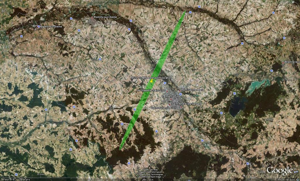
11 Detection Computation of accurate TDOA / FDOA Geoloc Examples 02/07/


12 Detection Computation of accurate TDOA / FDOA Carrier Cancellation Up to 60 MHz wide Carrier cancellation before correlation 02/07/
 /")
13 Location Accuracy Resolution of the final position Factors affecting location accuracy FDOA/TDOA accuracy.. Ephemeris.. Relative positions of the satellites and position of the references Hardware & Algorithm design to guarantee the best achievable processing gain Ephemeris generation tools Mono-site (Co-Orbits) / Multi-Site (passive) Expert system to analysis the most suitable measurement time and configuration 02/07/

14 Location Accuracy Resolution of the final position Principles Passive ephemeris estimation add-on to CGL geolocation system The passive method for geostationary satellite ephemeris estimation is based on differences distances measurement between the satellite and three ground stations installed in three different locations with an average 300 km distance gap. 02/07/

15 Location Accuracy Resolution of the final position Operating mode The operating mode then solely relies on a single reference carrier. The main purpose is to reach the accuracy at which one can use geolocation results without the use of additional reference transmitters. Satellite The system continuously streams main/mirror orbital data to the geolocation system: after stabilization phase, up to date, accurate data are available upon triggering of a geolocation task SPC L band Computer SPC L band Computer Screen SPC L band Computer Internet 02/07/
16 Operating Mode - Easing-up the process Operating mode Automated Detection & Geolocation. Full transponder.... Full Manual (Metrology Approach).. Distant Antennas. Interface with other applications.. Multi sites.. Autonomous system One-Click Modes Macro Task Manager Geolocation-aware transponder monitoring Continuous Co-Orbit Estimation Multi-Carrier oriented Hardware Design Expert mode Multi-site GPS synchronisation XML interfaces Scalable system architecture Stand alone system 02/07/
17 Operating Mode - Automated MacroTasks Architecture Main principles Input a given transponder frequency Automatic effort distribution over available processing and acquisition resources Network based architecture Manage the database Retrieve all results and database information MacroTask Manager Output Results (XML Format / XML-RPC) IFoIP IFoIP IFoIP Digitization Server Pools CSI CSI CSI CSA CSA CSA CGL CGL CGL Application (Virtual) Server Pools System Satellite and Signal Database 02/07/
")
18 Operating Mode - Automated MacroTasks Architecture Select your satellite and transponder Selection of the Transponder to Geolocate (based on the Main Database) 02/07/

19 Operating Mode - Automated MacroTasks Architecture Select your primary reference Primary Reference Selection 02/07/

20 Operating Mode - Automated MacroTasks Architecture Select your secondary references Secondary Reference Selection 02/07/
 02/07/2013-21")
21 Operating Mode - Automated MacroTasks Architecture Select the carriers to locate Set of all processed carriers Process Transponder Spectrum (72MHz) 02/07/

22 Operating Mode - Automated MacroTasks Architecture Results: positions & information on the carriers Detailed Data for all carriers Map Details for selected carriers 02/07/
")
23 Operating Mode - Automated MacroTasks Architecture Results: positions on the map World map with all positions of located carriers (positions tagged with carrier center frequency) 02/07/
24 Mitigation time Automated interference detection and geolocation Mitigation time Hardware performances.... Number of samples to process.. High processing.... Detection and Geolocation. Dedicated Hardware filtering architecture Multithreaded software 64-bit Multi-Core Optimized software Automated detection and Geolocation included in the CSM feature 02/07/
25 Mitigation time Automated interference detection and geolocation Satellite SHF-HLP LNA SHF-VLP LNA BDC SHF to L band BDC SHF to L band DIGITIZER SUBSYTEM Computer SDR Satellite SHF SHF-RHCP LNA SHF-LHCP LNA SHF-RHCP LNA SHF-LHCP LNA BDC SHF to L band BDC SHF to L band BDC SHF to L band BDC SHF to L band L BAND MATRIX L band inputs 2 L band inputs Ethernet output Ethernet output RJ45 RJ45 ETHERNET SWITCH Computer CSI Computer CSA CSM Flat screen Flat screen Satellite SHF SHF-VLP LNA SHF-HLP LNA BDC SHF to L band BDC SHF to L band SEE L band inputs Ethernet output RJ45 Computer CGL MTM Computer Database Flat screen Flat screen Flat screen SPC L band Computer SPC L band Computer SPC L band Computer Ethernet Link Remote link 02/07/
26 CSM Performances Learning mission Detection of all carriers Case of a new satellite CSM uses CSI to detect carriers CSI sends list of detected carrier to CSM 2 juillet


27 CSM Performances Learning mission Analysis of all carriers Case of a new satellite CSM uses CSA to do for all detected carriers blind analysis and to fill database. 2 juillet
28 CSM Performances Monitoring mission Monitoring of all carriers CSM uses CSI to check Quality of service for each defined carrier CSI sends list of results to CSM 2 juillet

29 CSM Performances Monitoring mission Monitoring of all carriers CSI sends list of new detected carrier, also list of disappear carrier to CSM 2 juillet

30 CSM Performances Monitoring mission Analysis and Geolocation of interference For a monitoring mission, operator can defined tasks will be launch when a new carrier is detected, like: Blind analysis; Blind analysis + save results in database; Geolocation; Blind analysis + geolocation 2 juillet


31 CGL Latest technologies Roadmap Coming up in the future New request TDMA signal Ka Band.. Spotted satellites Geolocation of the users Better accuracy with One Sat Downsizing system configuration 02/07/

32 Roadmap Geolocation of TDMA users In TDMA context 02/07/


33 Roadmap Geolocation of TDMA users In TDMA context Burst series 02/07/

34 Roadmap Geolocation of TDMA users In TDMA context Target manager: Several positions per carrier One single central frequency Several distinct locations 02/07/

35 Network example Geolocation of TDMA users 02/07/


36 ZDS Thank you! 02/07/
ZODIAC DATA SYSTEMS. Satellite Interference Reduction Group (IRG) November 2012 Dubai UAE.
 November 2012 Dubai UAE.") ZODIAC DATA SYSTEMS Satellite Interference Reduction Group (IRG) 18 20 November 2012 Dubai UAE. ZDS Software Defined Radio Product line thierry.balanche@zodiacaerospace.com Presentation to sirg 2012 18th
ZODIAC DATA SYSTEMS Satellite Interference Reduction Group (IRG) 18 20 November 2012 Dubai UAE. ZDS Software Defined Radio Product line thierry.balanche@zodiacaerospace.com Presentation to sirg 2012 18th
ZODIAC AIRCRAFT SYSTEMS ZODIAC DATA SYSTEMS
 ZODIAC DATA SYSTEMS 28/06/2015-2 Solutions based on IFoIP One hardware, Multiple applications 28/06/2015-3 Solutions based on IFoIP One hardware, Multiple applications Customized SDR Software Defined Radio
ZODIAC DATA SYSTEMS. ZODIAC AEROSYSTEMS Control Systems Division
 ZODIAC DATA SYSTEMS 6/14/2016-2 Monitoring : Produits & services Services Ephemeris and TDOA services Geolocation services Markets: Satellite Operators Regulatory Bodies Defense Agencies System Integrators
SIECAMS. Siemens Space. SIECAMS Siemens Satellite Monitoring System. Siemens AG Austria All rights reserved.
 Siemens Space SIECAMS Siemens Satellite Monitoring System Siemens AG Austria 2010. All rights reserved. Benefits Multi-site and multi-satellite system based on state of the art SW technology Less investment
ZODIAC DATA SYSTEMS. ZODIAC AIRCRAFT SYSTEMS Zodiac Data Systems July 22,
 Space Applications Ground Segment ZODIAC DATA SYSTEMS July 22, 2014-1 Business segment review 2 ComSats (Communication Satellites) Leading position maintained worldwide: Cortex CRT-Q provided for 28/28
Ofcom Systems Team. FCS BR18 Chateau Impney. Paul Jarvis. Monitoring Solutions. Baldock Radio Station Royston Road Baldock Herts
 FCS BR18 Chateau Impney Ofcom Systems Team Monitoring Solutions Baldock Radio Station Royston Road Baldock Herts Paul Jarvis Contents Introduction to the Technical Systems Team Overview Transmitter location
A SOFTWARE DEFINED RADIO BASED ARCHITECTURE FOR THE REAGAN TEST SITE TELEMETRY MODERNIZATION (RTM) PROGRAM
 PROGRAM") A SOFTWARE DEFINED RADIO BASED ARCHITECTURE FOR THE REAGAN TEST SITE TELEMETRY MODERNIZATION (RTM) PROGRAM David Ardrey, Gregory Gimler, Mark Pippitt * MIT Lincoln Laboratory Lexington, MA ABSTRACT MIT
A SOFTWARE DEFINED RADIO BASED ARCHITECTURE FOR THE REAGAN TEST SITE TELEMETRY MODERNIZATION (RTM) PROGRAM David Ardrey, Gregory Gimler, Mark Pippitt * MIT Lincoln Laboratory Lexington, MA ABSTRACT MIT
Satellite Interference Geolocation Considerations May 2016
 Satellite Interference Geolocation Considerations May 2016 Paul Chan, MIEEE, MIET, MSc. Telecommunications Spacecraft Engineer, Asia Satellite Telecommunications Co. Ltd. (AsiaSat) Introduction Interference
RFeye Node. Wideband intelligent spectrum system for remote distributed RF monitoring
 RFeye Node Wideband intelligent spectrum system for remote distributed RF monitoring Key features 6 GHz standard and 18 GHz frequency DF and geolocation capable extender Multiple RF ports for multi-antenna
Airborne Satellite Communications on the Move Solutions Overview
 Airborne Satellite Communications on the Move Solutions Overview High-Speed Broadband in the Sky The connected aircraft is taking the business of commercial airline to new heights. In-flight systems are
Exploring Trends in Technology and Testing in Satellite Communications
 Exploring Trends in Technology and Testing in Satellite Communications Aerospace Defense Symposium Giuseppe Savoia Keysight Technologies Agenda Page 2 Evolving military and commercial satellite communications
Optimising a Unified Space and Ground Segment
 Optimising a Unified Space and Ground Segment GVF Connectivity 2018: Evolving the "New" New Verticals Mark Lambert Mark.lambert@kratoscomms.com VP Business Development Kratos 1 Dramatic growth in satellites
1. Discuss in detail the Design Consideration of a Satellite Communication Systems. [16]
![1. Discuss in detail the Design Consideration of a Satellite Communication Systems. [16]](/thumbs/86/93666103.jpg "1. Discuss in detail the Design Consideration of a Satellite Communication Systems. [16]") Code No: R05410409 Set No. 1 1. Discuss in detail the Design Consideration of a Satellite Communication Systems. 2. (a) What is a Geosynchronous Orbit? Discuss the advantages and disadvantages of these
Code No: R05410409 Set No. 1 1. Discuss in detail the Design Consideration of a Satellite Communication Systems. 2. (a) What is a Geosynchronous Orbit? Discuss the advantages and disadvantages of these
UHF Phased Array Ground Stations for Cubesat Applications
 UHF Phased Array Ground Stations for Cubesat Applications Colin Sheldon, Justin Bradfield, Erika Sanchez, Jeffrey Boye, David Copeland and Norman Adams 10 August 2016 Colin Sheldon, PhD 240-228-8519 Colin.Sheldon@jhuapl.edu
RFeye Arrays. Direction finding and geolocation systems
 RFeye Arrays Direction finding and geolocation systems Key features AOA, augmented TDOA and POA Fast, sensitive, very high POI of all signal types Capture independent of signal polarization Antenna modules
model 802C HF Wideband Direction Finding System 802C
 model 802C HF Wideband Direction Finding System 802C Complete HF COMINT platform that provides direction finding and signal collection capabilities in a single integrated solution Wideband signal detection,
Event Detection From RF Sensing Space Symposium 2018 Technical Track. 16 April 2018
 Event Detection From RF Sensing Space Symposium 2018 Technical Track 16 April 2018 RF Sensing Background In 2010 Kratos RT Logic created a commercial network of SATCOM RF EMI Monitoring and Geolocation
RECOMMENDATION ITU-R SM * Measuring of low-level emissions from space stations at monitoring earth stations using noise reduction techniques
 Rec. ITU-R SM.1681-0 1 RECOMMENDATION ITU-R SM.1681-0 * Measuring of low-level emissions from space stations at monitoring earth stations using noise reduction techniques (2004) Scope In view to protect
Background. High Performance Earth Observation Satellites need High Bit Rate Down Link. SkySat-2 (100 kg) 300Mbps 8PSK in X-band
 300Mbps 8PSK in X-band") SSC16-VII-5 High bit-rate communication in X band for small earth observation satellites - Result of 505 Mbps demonstration and plan for 2 Gbps link - Hirobumi Saito Inst. Space and Astronautical Science,
SSC16-VII-5 High bit-rate communication in X band for small earth observation satellites - Result of 505 Mbps demonstration and plan for 2 Gbps link - Hirobumi Saito Inst. Space and Astronautical Science,
SPREAD SPECTRUM CHANNEL MEASUREMENT INSTRUMENT
 SPACE SPREAD SPECTRUM CHANNEL MEASUREMENT INSTRUMENT Satellite communications, earth observation, navigation and positioning and control stations indracompany.com SSCMI SPREAD SPECTRUM CHANNEL MEASUREMENT
From Antenna to Bits:
 From Antenna to Bits: Wireless System Design with MATLAB and Simulink Cynthia Cudicini Application Engineering Manager MathWorks cynthia.cudicini@mathworks.fr 1 Innovations in the World of Wireless Everything
Development of a Satellite Tracking Ground Station for the nsight-1 CubeSat Mission
 Development of a Satellite Tracking Ground Station for the nsight-1 CubeSat Mission Presented by: Francois Visser Date: 13 December 2017 Acknowledgements Dr Lourens Visagie University of Stellenbosch Hendrik
Satellite Communications Testing
 Satellite Communications Testing SATELLITE COMMUNICATIONS TESTING Traditionally, the satellite industry has relied on geosynchronous earth orbit (GEO) satellites that take years to build and require very
Case sharing of the use of RF Localization Techniques. Dr. Frank Tong LSCM R&D Centre LSCM Summit 2015
 Case sharing of the use of RF Localization Techniques Dr. Frank Tong LSCM R&D Centre LSCM Summit 2015 Outline A. LBS tracking and monitoring 1) Case of anti-wandering-off tracking vest system in elderly
Future Concepts for Galileo SAR & Ground Segment. Executive summary
 Future Concepts for Galileo SAR & Ground Segment TABLE OF CONTENT GALILEO CONTRIBUTION TO THE COSPAS/SARSAT MEOSAR SYSTEM... 3 OBJECTIVES OF THE STUDY... 3 ADDED VALUE OF SAR PROCESSING ON-BOARD G2G SATELLITES...
Satellite Sub-systems
 Satellite Sub-systems Although the main purpose of communication satellites is to provide communication services, meaning that the communication sub-system is the most important sub-system of a communication
OASIS. Application Software for Spectrum Monitoring and Interference Analysis
 OASIS Application Software for Spectrum Monitoring and Interference Analysis OASIS Features User friendly Operator interface Hardware independent solution Choose the receiver that you already own or that
SATELLITE SUBSYSTEMS. Networks and Communication Department. Dr. Marwah Ahmed
 1 SATELLITE SUBSYSTEMS Networks and Communication Department Dr. Marwah Ahmed Outlines Attitude and Orbit Control System (AOCS) Telemetry, Tracking, Command and Monitoring (TTC & M) Power System Communication
Passive Radar at home
 Passive Radar at home Electrosmog made useful Signal analysis magic with received radio signals and their reflections Martin Dudok van Heel PA1SDR@olifantasia.com http://www.olifantasia.com European USRP
Annex B: HEO Satellite Mission
 Annex B: HEO Satellite Mission Table of Content TABLE OF CONTENT...I 1. INTRODUCTION...1 1.1. General... 1 1.2. Response Guidelines... 1 2. BRAODBAND CAPACITY...2 2.1. Mission Overview... 2 2.1.1. HEO
Ground Station Design for STSAT-3
 Technical Paper Int l J. of Aeronautical & Space Sci. 12(3), 283 287 (2011) DOI:10.5139/IJASS.2011.12.3.283 Ground Station Design for STSAT-3 KyungHee Kim*, Hyochoong Bang*, Jang-Soo Chae**, Hong-Young
IZT C6000 RF Link Emulator
 www.izt-labs.de IZT C6000 RF Link Emulator Bi-directional wideband solutions for up to 600 MHz bandwidth Simulation of complete satellite links including payload, uplink and downlink effects Simulation
Innovationszentrum für Telekommunikationstechnik IZT. COMINT Technology
 Innovationszentrum für Telekommunikationstechnik IZT COMINT Technology March 2011 Overview Company Profile Signal Sources S1000 COMINT Simulator Digital Wideband Receivers R3000 RecPlay System R4000 About
C Band Telemetry at Airbus Flight Test Centre
 C Band Telemetry at Airbus Flight Test Centre Item Type text; Proceedings Authors Fréaud, Gilles Publisher International Foundation for Telemetering Journal International Telemetering Conference Proceedings
2015 The MathWorks, Inc. 1
 2015 The MathWorks, Inc. 1 What s Behind 5G Wireless Communications? 서기환과장 2015 The MathWorks, Inc. 2 Agenda 5G goals and requirements Modeling and simulating key 5G technologies Release 15: Enhanced Mobile
Optical Correlator for Image Motion Compensation in the Focal Plane of a Satellite Camera
 15 th IFAC Symposium on Automatic Control in Aerospace Bologna, September 6, 2001 Optical Correlator for Image Motion Compensation in the Focal Plane of a Satellite Camera K. Janschek, V. Tchernykh, -
MICROSCOPE Mission operational concept
 MICROSCOPE Mission operational concept PY. GUIDOTTI (CNES, Microscope System Manager) January 30 th, 2013 1 Contents 1. Major points of the operational system 2. Operational loop 3. Orbit determination
Platform Independent Launch Vehicle Avionics
 Platform Independent Launch Vehicle Avionics Small Satellite Conference Logan, Utah August 5 th, 2014 Company Introduction Founded in 2011 The Co-Founders blend Academia and Commercial Experience ~20 Employees
Ground Systems for Small Sats: Simple, Fast, Inexpensive
 Ground Systems for Small Sats: Simple, Fast, Inexpensive but Effective 15 th Ground Systems Architecture Workshop March 1, 2011 Mr Andrew Kwas, Mr Greg Shreve, Northrop Grumman Corp, Mr Adam Yozwiak, Cornell
A SDR-based receiver for Es hail-2 and the BACAR 6, 10 GHz beacons 30 July 2018
 A SDR-based receiver for Es hail-2 and the BACAR 6, 10 GHz beacons 30 July 2018 Hannes Coetzee, ZS6BZP Introduction If all goes according to plan the Qatar Satellite Company (Es hailsat) will place its
What s Behind 5G Wireless Communications?
 What s Behind 5G Wireless Communications? Marc Barberis 2015 The MathWorks, Inc. 1 Agenda 5G goals and requirements Modeling and simulating key 5G technologies Release 15: Enhanced Mobile Broadband IoT
Development of the Satellite Ground Control System for Multi-mission Geostationary Satellite COMS
 SpaceOps 2010 ConferenceDelivering on the DreamHosted by NASA Mars 25-30 April 2010, Huntsville, Alabama AIAA 2010-2381 Development of the Satellite Ground Control System for Multi-mission
Recommendation ITU-R M (09/2015)
") Recommendation ITU-R M.1906-1 (09/2015) Characteristics and protection criteria of receiving space stations and characteristics of transmitting earth stations in the radionavigation-satellite service (Earth-to-space)
Recommendation ITU-R M.1906-1 (09/2015) Characteristics and protection criteria of receiving space stations and characteristics of transmitting earth stations in the radionavigation-satellite service (Earth-to-space)
Dive deep into interference analysis
 Dive deep into interference analysis Dive deep into interference analysis Contents 1. Introducing Narda Outstanding features 2. Basics IDA 2 3. IDA 2 presentation How IDA 2 is used: 1) Detect 2) Analyze
The Use of MESH Technology in Outside Broadcast
 Cobham Surveillance Domo Products 11 Manor Court, Barnes Wallis Road, Segensworth, Hampshire, PO15 5TH England T: +44 (0)1489 566 750 F: +44 (0)1489 880 538 The Use of MESH Technology in Outside Broadcast
Precision Validation, Maintenance and Repair of Satellite Earth Stations
 Precision Validation, Maintenance and Repair of Satellite Earth Stations September 18, 2014 Co-sponsored by Keysight Technologies 2014 Tom Hoppin Application Specialist Component Test Division Keysight
innovative technology to keep you a step ahead
 Detect Bursty Ingress and Impulse Noise Interference to Voice Services with Extremely High Spectrum Acquisition Speed Manage Service Quality Efficiently with 24/7 Monitoring and Configurable SNMP Alarms
S-Band TTCET Ground Station
 S-Band TTCET Ground Station Main Performances Reception frequency range : S Band: 2200 to 2300 MHz Downlink Budget G/T S band : > 10 db/ K @ 10 of elevation in whole Bandwidth Emission frequency range
SATELLIT COMMUNICATION
 QUESTION BANK FOR SATELLITE COMMUNICATION UNIT I 1) Explain Kepler s laws. What are the fords that give rise to these laws? 2) Explain how a satellite is located with respect to earth. 3) Describe antenna
SATELLITE COMMUNICATION
 SATELLITE COMMUNICATION Monojit Mitra SATELLITE COMMUNICATION SATELLITE COMMUNICATION MONOJIT MITRA Assistant Professor Department of Electronics and Telecommunication Engineering Bengal Engineering and
5G and mmwave Testing
 5G and mmwave Testing 5G and mmwave Testing The development and deployment of 5G technology is changing the way wireless carriers and internet service providers think about meeting the ever increasing
Space Systems Engineering
 Space Systems Engineering This course studies the space systems engineering referring to spacecraft examples. It covers the mission analysis and design, system design approach, systems engineering process
L76-L GNSS Module Presentation
 L76-L GNSS Module Presentation May, 2016 Quectel Wireless Solutions Co., Ltd. All rights reserved www.quectel.com Contents Highlights Advanced Features Quectel L76-L vs. Competitor s Product Support Package
Frequency bands and transmission directions for data relay satellite networks/systems
 Recommendation ITU-R SA.1019-1 (07/2017) Frequency bands and transmission directions for data relay satellite networks/systems SA Series Space applications and meteorology ii Rec. ITU-R SA.1019-1 Foreword
MC108A-2 RF MULTI-COUPLER USER S GUIDE
 MC108A-2 RF MULTI-COUPLER USER S GUIDE Systems Engineering & Management Company 1430 Vantage Court Vista, California 92081 PROPRIETARY INFORMATION THE INFORMATION CONTAINED IN THIS DOCUMENT CONSTITUTES
AIRBORNE SATELLITE COMMUNICATIONS ON THE MOVE
 AIRBORNE SATELLITE COMMUNICATIONS ON THE MOVE December 2014 Introduction Military forces require situational awareness no matter where they re located. From warfighters in the field, sailors on navy ships,
Emergency Locator Signal Detection and Geolocation Small Satellite Constellation Feasibility Study
 Emergency Locator Signal Detection and Geolocation Small Satellite Constellation Feasibility Study Authors: Adam Gunderson, Celena Byers, David Klumpar Background Aircraft Emergency Locator Transmitters
Satellite trends. Technical and business technology. and regulatory challenges
 Satellite trends Technical and business technology and regulatory challenges Attila MATAS am@orbitspectrum.ch WRC-15 GFT Decision Seamless satellite based ADS-B GFT - world wide coverage 2 ITU WRC-15 UAS
B ==================================== C
 Satellite Space Segment Communication Frequencies Frequency Band (GHz) Band Uplink Crosslink Downlink Bandwidth ==================================== C 5.9-6.4 3.7 4.2 0.5 X 7.9-8.4 7.25-7.7575 0.5 Ku 14-14.5
FM DISTRIBUTION FOR MOTORWAYS AND TUNNELS
 FM DISTRIBUTION FOR MOTORWAYS AND TUNNELS ADVANTAGES IF COMPARED TO A TRADITIONAL SYSTEM As compared to the traditional analog systems, our innovative solution for FM transmission allows considerable cost
Air Force Institute of Technology. A CubeSat Mission for Locating and Mapping Spot Beams of GEO Comm-Satellites
 Air Force Institute of Technology A CubeSat Mission for Locating and Mapping Spot Beams of GEO Comm-Satellites Lt. Jake LaSarge PI: Dr. Jonathan Black Dr. Brad King Dr. Gary Duke August 9, 2015 1 Outline
Innovative Solutions for Applied Communications in O&G
 / 03-2014 Innovative Solutions for Applied Communications in O&G Page 1 siemens.com/convergence-creators , Where we are Worldwide activities with a solid presence in Europe USA Los Angeles Czech Praha
Preparing RF Situational Awareness On Major Events. Jérôme Duboé ITU Regional Seminar for CIS and Europe Kyiv, Ukraine, July 2013
 Preparing RF Situational Awareness On Major Events Jérôme Duboé ITU Regional Seminar for CIS and Europe Kyiv, Ukraine, 10-12 July 2013 Presentation Agenda Major Events Ever Impacted by Satellites Interferences?
NetCubeSat and SDR Based Communication System for Climate Change Understanding
 NetCubeSat and SDR Based Communication System for Climate Change Understanding Omar Ben Bahri 1, omar.benbahri@fsm.rnu.tn Nissen Lazreg 1,Nader Gallah 1, Amani Chaouch 1 & Pr. Kamel Besbes 1,2 1 Monastir
4 channel low power Active DAS tray with power monitoring and attenuation control (+18dBm maximum average
 Active DCC Brochure DCC500 Series Products DAS Control Rack (DCR) A broadband active multi-channel device with programmable uplink/downlink variable attenuators and RMS power monitors for remote or local
Advanced Digital Receiver
 Advanced Digital Receiver MI-750 FEATURES Industry leading performance with up to 4 M samples per second 135 db dynamic range and -150 dbm sensitivity Optimized timing for shortest overall test time Wide
Telemeasured Performances of a DSP based CDMA Software Defined Radio
 Telemeasured Performances of a DSP based CDMA Software Defined Radio Abstract Marco Bagnolini, Cristian Alvisi, Alberto Roversi, Andrea Conti, Davide Dardari and Oreste Andrisano A tele-measurement experience
Vidyut: Exploiting Power Line Infrastructure for Enterprise Wireless Networks. Vivek Yenamandra and Kannan Srinivasan
 Vidyut: Exploiting Power Line Infrastructure for Enterprise Wireless Networks Vivek Yenamandra and Kannan Srinivasan Motivation Increasing demand for wireless capacity Proliferation of BYOD in workplaces
Jager UAVs to Locate GPS Interference
 JIFX 16-1 2-6 November 2015 Camp Roberts, CA Jager UAVs to Locate GPS Interference Stanford GPS Research Laboratory and the Stanford Intelligent Systems Lab Principal Investigator: Sherman Lo, PhD Area
MEO Satellite Applications to Support Mobility
 MEO Satellite Applications to Support Mobility Colloquium on Satellite Services for Global Mobility 14 October, 2013 David Burr, Director, Product Development O3b A revolutionary solution O3b Networks
Digital Return System
 SG4 DRT 2X 85 and MBN DRT 2X 85 Transmitters GX2 DRR 2X 85 and CHP D2RRX 85 Receivers FEATURES Allows return bandwidth expansion up to 85 MHz Easy node segmentation with 2X RF TDM Simplified logistics
Design of Xilinx Based Telemetry System Using Verilog
 Design of Xilinx Based Telemetry System Using Verilog N. P. Lavanya Kumari 1, A. Sarvani 2, K. S. S. Soujanya Kumari 3, L. Y. Swathi 4, M. Purnachandra Rao 5 1 Assistant.Professor (C), Department of Systems
Deep Space Communication The further you go, the harder it gets. D. Kanipe, Sept. 2013
 Deep Space Communication The further you go, the harder it gets D. Kanipe, Sept. 2013 Deep Space Communication Introduction Obstacles: enormous distances, S/C mass and power limits International Telecommunications
120W UHF Transmitter/Repeater
 Product Features 470 MHz - 860 MHz Broadband Transmitter/Repeater LDMOS Power Amplifier provides 120 Watt output for ATSC, ATSC-M/H, CMMB, DTMB, DVB-T/H, DVB-T2, DVB-SH, ISDB-T/TB,, DAB, DAB+ and T-DMB
GNSS Remo Sensing in ensin a 6U Cubesat
 GNSS Remote Sensing in a 6U Cubesat Andrew Dempster Remote Sensing using GNSS Radio occultation Well established, with existing missions, v useful for input to weather models Reflectometry Experimental,
TELEMETRY, TRACKING, COMMAND AND MONITORING SYSTEM IN GEOSTATIONARY SATELLITE
 TELEMETRY, TRACKING, COMMAND AND MONITORING SYSTEM IN GEOSTATIONARY SATELLITE Alish 1, Ritambhara Pandey 2 1, 2 UG, Department of Electronics and Communication Engineering, Raj Kumar Goel Institute of
A Fully Network Controlled Flight Test Center and Remote Telemetry Centers
 A Fully Network Controlled Flight Test Center and Remote Telemetry Centers Item Type text; Proceedings Authors Rubio, Pedro; Jimenez, Francisco; Alvarez, Jesus Publisher International Foundation for Telemetering
ARTEMIS: Low-Cost Ground Station Antenna Arrays for Microspacecraft Mission Support. G. James Wells Mark A. Sdao Robert E. Zee
 ARTEMIS: Low-Cost Ground Station Antenna Arrays for Microspacecraft Mission Support G. James Wells Mark A. Sdao Robert E. Zee Space Flight Laboratory University of Toronto Institute for Aerospace Studies
TRX-300. GPS/GSM/GPRS Unit for fleet management PRELIMINARY PHOTO
 PRELIMINARY TRX-300 GPS/GSM/GPRS Unit for fleet management Quad Band GSM/GPRS engine Built-in GPS & GPRS antenna SuperSense GPS sensitivity Assisted GPS ready Ultra-low power consumption Multi-polygon
Measuring and monitoring with precision. NRA-RX Narda Remote Analyzer
 Measuring and monitoring with precision NRA-RX Narda Remote Analyzer Exceptional: Measurement range. Exemplary: Price and performance The Narda NRA Series is a winner, thanks to its exceptional range of
Update on GPS L1C Signal Modernization. Tom Stansell Aerospace Consultant GPS Wing
 Update on GPS L1C Signal Modernization Tom Stansell Aerospace Consultant GPS Wing Glossary BOC = Binary Offset Carrier modulation C/A = GPS Coarse/Acquisition code dbw = 10 x log(signal Power/1 Watt) E1
Sang-Tae Kim, Seong-Yun Lee. Radio Technology Research Department
 Trends and Technology Of Radio Monitoring In Korea Sang-Tae Kim, Seong-Yun Lee Radio Technology Research Department 1 Contents I Trends of Radio Monitoring II Design Concepts of Radio Monitoring System
Implementation and Performance Evaluation of a Fast Relocation Method in a GPS/SINS/CSAC Integrated Navigation System Hardware Prototype
 This article has been accepted and published on J-STAGE in advance of copyediting. Content is final as presented. Implementation and Performance Evaluation of a Fast Relocation Method in a GPS/SINS/CSAC
Agilent AN 1275 Automatic Frequency Settling Time Measurement Speeds Time-to-Market for RF Designs
 Agilent AN 1275 Automatic Frequency Settling Time Measurement Speeds Time-to-Market for RF Designs Application Note Fast, accurate synthesizer switching and settling are key performance requirements in
securing oman s spectrum Tracing the journey to building the region s most ambitious Advanced Space Radio Monitoring Station ISSUE 71 MARCH 2019
 ISSUE 71 MARCH 2019 Publication licensed by Dubai Production City securing oman s spectrum Tracing the journey to building the region s most ambitious Advanced Space Radio Monitoring Station safeguarding
The Cricket Indoor Location System
 The Cricket Indoor Location System Hari Balakrishnan Cricket Project MIT Computer Science and Artificial Intelligence Lab http://nms.csail.mit.edu/~hari http://cricket.csail.mit.edu Joint work with Bodhi
High Gain Advanced GPS Receiver
 High Gain Advanced GPS Receiver NAVSYS Corporation 14960 Woodcarver Road, Colorado Springs, CO 80921 Introduction The NAVSYS High Gain Advanced GPS Receiver (HAGR) is a digital beam steering receiver designed
Relative Navigation, Timing & Data. Communications for CubeSat Clusters. Nestor Voronka, Tyrel Newton
 Relative Navigation, Timing & Data Communications for CubeSat Clusters Nestor Voronka, Tyrel Newton Tethers Unlimited, Inc. 11711 N. Creek Pkwy S., Suite D113 Bothell, WA 98011 425-486-0100x678 voronka@tethers.com
KA-BAND EQUIPMENT ASSEMBLY
 KA-BAND EQUIPMENT ASSEMBLY FOR MULTIMEDIA SATELLITE PAYLOADS PATRICE ULIAN, HERVÉ LEVEQUE, AGNÈS RECLY, JEAN-CHRISTOPHE CAYROU, BERNARD COGO, JEAN-LOUIS CAZAUX e-mail : patrice.ulian@space.alcatel.fr ALCATEL
Your Network. Optimized.
 Over 20 years of research both at the National Institute of Standards and Technology (NIST) and in private industry have been dedicated to the research and development of Symmetricom s phase noise and
DICE Telemetry Overview and Current Status
 DICE Telemetry Overview and Current Status CubeSat Workshop, April 2012 Jacob Gunther Overview DICE telemetry overview Operations experience and timeline Narrowband interference mitigation Frequency domain
Monitoring Station for GNSS and SBAS
 Monitoring Station for GNSS and SBAS Pavel Kovář, Czech Technical University in Prague Josef Špaček, Czech Technical University in Prague Libor Seidl, Czech Technical University in Prague Pavel Puričer,
How To Summon Up Those Darn Clouds When You Need Them
 Mark Lambert Vice President - EMEA How To Summon Up Those Darn Clouds When You Need Them 2013 Advantech Wireless Inc 1 Overview Introduction to Advantech Use of the Cloud in the Oil & Gas sector - What
Application of a Dual Satellite Geolocation System on Locating Sweeping Interference
 Application of a Dual Satellite Geolocation System on Locating Sweeping Interference M. H. Chan Abstract This paper describes an application of a dual satellite geolocation (DSG) system on identifying
Stay informed and entertained in flight. Live satellite television for super-mid and long-haul aircraft in the contiguous United States.
 tailwind 300 Stay informed and entertained in flight. Live satellite television for super-mid and long-haul aircraft in the contiguous United States. Affordable information and entertainment from a reliable
TDOA-Based Localization Using Distributed Sensors Based on Commodity Hardware. EW Europe 2017 London
 TDOA-Based Localization Using Distributed Sensors Based on Commodity Hardware EW Europe 2017 London Dana Christen dc@decodio.com Agenda 1. TDoA: introduction and principle 2. Workflow overview 3. Hardware
Experiment of 348 Mbps downlink from 50-kg class satellite
 10th IAA Symposium on Small Satellites for Earth Observation April 20-24, 2015 Berlin, Germany IAA-B10-1302 Experiment of 348 Mbps downlink from 50-kg class satellite Tomoya Fukami, The University of Tokyo
DYNAMICALLY RECONFIGURABLE SOFTWARE DEFINED RADIO FOR GNSS APPLICATIONS
 DYNAMICALLY RECONFIGURABLE SOFTWARE DEFINED RADIO FOR GNSS APPLICATIONS Alison K. Brown (NAVSYS Corporation, Colorado Springs, Colorado, USA, abrown@navsys.com); Nigel Thompson (NAVSYS Corporation, Colorado
5G deployment below 6 GHz
 5G deployment below 6 GHz Ubiquitous coverage for critical communication and massive IoT White Paper There has been much attention on the ability of new 5G radio to make use of high frequency spectrum,
Wireless Broadband Solutions for Autonomous Ground Vehicles
 Wireless Broadband Solutions for Autonomous Ground Vehicles State-of-the-art wireless MIMO for Command and Control + long range video streaming 2019 Doodle Labs. All rights reserved. 1 Wireless Communication