WMO Oscar/Space Database Update
|
|
|
- Roberta Singleton
- 5 years ago
- Views:
Transcription

1 WMO Oscar/Space Database Update 14th International Winds Workshop (IWW14) April 2018, Jeju, Republic of Korea Toshiyuki Kurino WMO Space Programme
2 Contents What is WMO OSCAR OSCAR/Space maintenance Scheme IWWG s contributions to OSCAR/Space Recommendations for strengthening the overall process


3 What is WMO OSCAR? (

4 Statistics on OSCAR/Space Audience
5 Statistics on OSCAR/Space Audience
6 WMO Observing System Capability Analysis and Review tool (OSCAR) WMO-maintained online resource with 3 components: OSCAR/Space: satellite programmes, instruments, and the variables they can observe OSCAR/Surface: surface-based stations/platforms under WIGOS OSCAR/Requirements: observation requirements for 14 application areas and for all relevant variables Variables Variables OSCAR/ Space OSCAR/ Requirements OSCAR/ Surface WIGOS Information Resource Basis for WMO Rolling Review of Requirements

7 OSCAR/Requirements provides.. 14 WMO Application Areas: OSCAR/ Requirements - Global Numerical Weather Prediction - High-resolution Numerical Weather Prediction - Nowcasting - Sub-seasonal to Longer-range Forecasting - Forecasting Atmospheric Composition - Monitoring Atmospheric Composition - Atmospheric Composition info services in urban and populated areas - Ocean Applications - Aeronautical Meteorology - Agricultural Meteorology - Hydrology - Climate Monitoring (GCOS) [now including GFCS requirements] - Climate Applications - Space Weather

8 from Top Page of the OSCAR/Requirements Wind (horizontal)


")


9 Layer Application Results of searching Uncertainty Area Wind (horizontal) in 761 Coverage variables The Atmospheric Observation Panel for Climate (AOPC) was established by the GCOS Steering Committee in recognition of the need for specific scientific and technical input concerning atmospheric observations for climate. goal is marked blue, breakthrough green and threshold orange

10
 - Mapping instruments to measured variables - Gap Analysis by measured variable, or by type of mission - The built-in Expert")
11 OSCAR/Space Database System 1. Factual information on satellites and instruments ( capabilities ) OSCAR/ Space 81 agencies 673 satellites 927 instruments 2. Assessment of instruments, and Gap Analyses ( analysis and review ) - Mapping instruments to measured variables - Gap Analysis by measured variable, or by type of mission - The built-in Expert system will infer the prioritized results?????

12 (Part 1) Looking-up information Agency Programme Satellite Name, purpose Mass, power Orbit (type, alt, ECT, longitude) Launch date, end date, status Data access, telecom frequencies Payload status Instrument status, dates Link to calibration events Instruments Name, purpose Mass, power Type, description, scan mode Resolution, FOV, coverage Status Spectral characteristics

13 Looking-up Satellite Programme selecting Programmes from Top Page of the OSCAR/Space

14 Satellite Programmes Total: 236 Example Filter: ISRO, currently active programmes

15 Satellite Programmes: ISRO, active programmes Example Satellites: INSAT-3DR
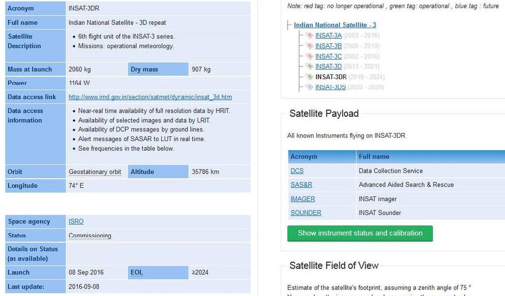
16 Satellite: INSAT-3DR
 selecting Overview from Top")

17 Looking-up Payload status (example: Metop-A) selecting Overview from Top Page of the OSCAR/Space Search: Metop (automatic dropdown menu after 2 typed letters)


18 Payload status, Calibration events Example: Metop-A

 GSICS MHS degradation")

19 Payload status, Calibration events Example: Metop-A eumetsat.int Landing page Direct Link to GSICS (in planning) GSICS MHS degradation
20 for Frequency management What is the potential impact on Jason missions of proposals for sharing MHz (C band) with commercial broadband providers? Give me all satellites that use C band, for sensing or for telecommunication

21 selecting Frequencies from Top Page of the OSCAR/Space

22 Information for frequency management Filter C band range


23 Information for frequency management: Sensing and telecom frequencies Total: 49

24 Frequency information: Jason-3
25 (Part 2) Assessments: Gap Analyses Two sides of the same relationship: Which variables can be measured with a given instrument? Which capability does the instrument contribute to? Which instruments can measure a given variable? Which instruments are responding to the WMO Vision? and during which period of time?


26 OSCAR/Space is a tool for Gap Analysis Requirements Requirements Requirements Requirements OSCAR/ Requirements Long-term WIGOS Vision 2025 / 2040 Gap Analysis Statement of Guidance Implementation Plan (Actions,Recom) Database on the Global Observing System OSCAR/ Surface Members agencies and programmes OSCAR/ Space


27 Instrument-variable mapping principle Variable 1 Variable 2 Variable 3 Variable 4 Required instrument specifications: Variable x Variable y Spectral bands XX XX X X Bandwidth No of channels X X X X XX X XX X X X X X Polarization X X XX XX Scanning mode X X X X X X Etc..


28 Gap Analysis from Instruments : Scatterometer selecting Instruments from Top Page of the OSCAR/Space

29


30 Instrument: ASCAT Gap Analysis from Variables

31 Measurement timeline for Wind speed over the surface (horizontal) (Definition: Module of the horizontal component of the 3D wind vector)


32 Relevance Gap analysis


33 Flag instrument issue indicates degradion Orbit Gap analysis

34 selecting Gap Analysis from Top Page of the OSCAR/Space

35
36 OSCAR/Space Maintenance Scheme
37 Maintenance and Support: Outlook Two main tasks for OSCAR/Space: (1) Updating facts (2) Keep under review assessments, functions, rules, interfaces Under supervision of WMO CBS expert teams, e.g. ET-SAT, IPET-SUP, IPT-SWeISS, and consistent with overall OSCAR development (with OSCAR/Surface and OSCAR/Requirement) WMO Space Programme office plans to establish: - OSCAR/Space Support Team (for task 1) - OSCAR/Space Science and Technical Advisory Team (task 2)
 for maintenance - CGMS Members, Observers - Other")
38 Maintenance and Support Scheme for OSCAR/Space ET-SAT Expert Team on Satellite Systems IPET-SUP Inter-Programme Expert Team on Satellite Utilization and Products WMO Expert Teams WMO Space Programme Office IPT-SWeISS Inter-Programme Team on Space Weather Information, Systems and Services OSCAR Project Board OSCAR/Space Support Team (O/SST) for maintenance - CGMS Members, Observers - Other partners OSCAR/Space Science and Technical Advisory Team (O/SSAT) - CGMS International Science Working Groups: ITWG Sounding IWWG Winds IPWG Precipitation IROWG Radio Occultation ICWG Clouds - WMO GSICS, SCOPE-CM, SCOPE-NC
39 IWWG s Contributions to OSCAR/Space
40 Questions/Advices from IWWG for AMVs (Horizontal) Capabilities in OSCAR/Space Gap Analyses by Variable (0/2) Questions/Advices What are the definitions for the various Relevance Designations (very high, high, fair, etc) and do they exist somewhere on the OSCAR site? Knowing these definitions would enable more consistent Relevance labelling of the various observation sources. Comments The ratings provide a qualitative idea of the relative achievable performance of the retrievals from instruments of different types and characteristics. The rating is a blending of several elements: the uncertainty, the vertical resolution, and the frequency and spatial resolution of the retrieved measurement in comparison with the space-time variability of the geophysical parameter. It is planned to add the Rating criteria to the Gap analysis by Variable in order to make the User aware of the background for the quoted rates.
41 Questions/Advices from IWWG for AMVs (Horizontal) Capabilities in OSCAR/Space Gap Analyses by Variable (1/2) Questions/Advices - Relevance of ABI, AHI, FCI is marked as "Very high" in contrast to the previous GOES or MTSAT imagers or SEVIRI (which are "high")? The capabilities or quality of ABI, AHI and FCI might be better (although not necessarily in a major way for winds), but it is thought that the relevance for AMVs is the same for all these instruments and should be very high. - Relevance is marked as "fair" for MODIS, VIIRS and MetImage, and "marginal" for AVHRR. However, both MODIS, VIIRS and AVHRR AMVs are currently assimilated in NWP models. So it is thought that high or very high rating should be more appropriate, even if it is understood that VIIRS and AVHRR might be rated lower than MODIS or METImage due to the lack of availability of WV channels for example. In fact METImage is very similar to SEVIRI (VIS, IR and WV channels used for AMVs) and the relevance to extract the winds is then rather similar for the 2 instruments even if the coverage is different. In fact coverage of GEO and LEO are seen as complementary and be not rated as more or less important. Comments The current rating criteria are: 1. Doppler lidar 2. Hyperspectral sounder in GEO; OR Imager in GEO or Molniya with channels in VIS and TIR at 6-8, and 13.3 µm 3. Imager in GEO or Molniya with channels in VIS and TIR at 6-8 and µm 4. TIR imager in LEO with channels at 6-8 and µm; OR Imager in GEO with channels in VIS and TIR at µm; OR High-spatialreolution multi-angle VIS radiometer in LEO; OR Very-high spectral resolution limb sounding spectrometer for oxygen lines in the VIS and NIR ranges 5. VIS imager in GEO; OR TIR imager at µm in LEO
42 Example of Rules (rating value is «subjective») Variable: Atmospheric temperature Instrument type Main relevant Property Rating Operational limitations IR radiometer No. of channels in the 15 µm band (in LEO) 3.4 Cloud sensitive, coarse vert. resolution No. of channels in the 15 µm band (in GEO) 3.3 Cloud sensitive, coarse vert. resolution No. of channels in the 4.3 and 15 µm bands (in LEO) 3.1 Cloud sensitive, coarse vert. resolution No. of channels in the 4.3 and 15 µm bands (in GEO) 3.0 Cloud sensitive, coarse vert. resolution IR spectrometer Spectral resolution in the 15 µm band (in LEO) 2.2 Cloud sensitive Spectral resolution in the 15 µm band (in GEO) 2.1 Cloud sensitive Spectral resolution in the 4.3 and 15 µm bands (in LEO) 1.3 Cloud sensitive Spectral resolution in the 4.3 and 15 µm bands (in GEO) 1.0 Cloud sensitive MW radiometer No. of channels in the 54 GHz band (conical scanning) 2.3 No specific limitation No. of channels in the 54 and 118 GHz bands (conical scanning) 2.0 No specific limitation No. of channels in the 54 GHz band (cross-track scanning) 1.4 No specific limitation No. of channels in the 54 and 118 GHz bands (cross-track scanning) 1.1 No specific limitation Limb sounder Short-wave spectrometry in occultation 5.1 Daylight, high atmosphere only Short-wave spectrometry by mechanical/electronic scanning 5.0 Daylight, high atmosphere only IR spectrometry 4.1 High atmosphere only Millimetre-submillimetre wave spectrometry 4.0 High atmosphere only R.O. sounder No. of soundings / day (single satellite) 3.2 Inaccurate in low troposphere No. of soundings / day (satellite cluster) 1.2 Inaccurate in low troposphere 42
43 Requests from IWWG for AMVs (Horizontal) Capabilities in OSCAR/Space Gap Analyses by Variable (2/2) Requests Operational limitation is marked as "Polar Regions only" for MODIS, VIIRS, MetImage, and AVHRR. AMVs using these data are extracted up to 50 deg latitude (single mode AVHRR and Leo-Geo) and have a global coverage for dual Metop AVHRR operations. It is proposed to replace the operational limitation "Polar Regions only" by "High latitudes" and to precise that the coverage is global for Dual operations for AVHRR and METImage. 3D winds are presently produced in a demonstration mode at CIMSS from AIRS instrument. It is proposed to add AIRS in the list and to set the relevance to marginal or fair. Accepted Proposal Polar regions only is now re-worded as Limited to high latitudes. The addition of variable Wind (horizontal) in the capability of hyperspectral sounders in LEO was implemented and reviewed by IWWG.
44 Questions/Advices from IWWG for AMVs (Horizontal) Capabilities in OSCAR/Space Multi-purpose VIS/IR from GEO Questions/Advices AMVs are mentioned in the #1 rating, as well as the #4 rating. This is a bit confusing. AMVs are mentioned in all the ratings, which is fine if AMVs can be produced from the available observations described in each rating. The red colour code designation says: VIS/IR radiometer with >=1 channel(s) in VIS, in the TIR window ~ 11 μm and (possibly) in the TIR water vapour 6.3 μm band. Basic operational cloud and cloud motion monitoring limited to daylight. The last sentence is only true IF only a VIS band is present, but the red colour designation seems to indicate the availability of 11um window observations. Comments AMV is possible with different level of performances, depending on the available channels. The rating, however, is determined by the set of all the Variables retrievable from the specified set of channels, not AMV only. This rating category refers to instruments with a minimal number of channels, but inclusive of VIS, therefore only possible in daylight. AMV are included, provided that also there is IR (for height assignment).
45 Questions/Advices from IWWG for AMVs (Horizontal) Capabilities in OSCAR/Space Multi-purpose VIS/IR from LEO Questions/Advices AMVs aren t mentioned. AMVs are now extracted from several LEO satellites (MODIS, AVHRR, VIIRS, MISR) and presently used in NWP models for high latitude areas. They will be extracted in the future from at least EPS-SG METImage and S3/SLSTR. AMVs must appear in the multi-purpose VIS/IR imagery from LEO list. Comments AMV is not mentioned here because not driving for the rating of the mission Multi-purpose VIS/IR from LEO. It appears, however, listed and rated under each instrument equipped with the appropriate channels. Note: Multi-purpose VIS/IR from GEO and Multi-purpose VIS/IR from LEO will be merged in future updating, and the rating definition will be rearranged. IWWG comments will be taken into account
46 Requests from IWWG for AMVs (Horizontal) Capabilities in OSCAR/Space IR temperature/humidity sounding from LEO Requests wind profile in clear air is mentioned for GEO but not for LEO. 3D winds are presently derived in a demonstration mode from AIRS at CIMSS and 3D winds are also planned to be extracted from Metop IASI. The coverage is limited to high latitudes. It is proposed to add the wind profile in clear air mention also for LEO IR sounders. Accepted Proposal The addition of variable Wind (horizontal) in the capability of hyperspectral sounders in LEO was implemented and reviewed by IWWG
47 Questions/Advices from IWWG for AMVs (Horizontal) Capabilities in OSCAR/Space Observation Requirement Variable: Wind (horizontal) Questions/Advices What are definitions of High Low Troposphere? Perhaps, Mid troposphere should be included as one of the layer designations Comments The terms Lower troposhere, Higher troposphere, Lower stratoshere and Higher stratosphere and Mesosphere have been agreed long ago, accounting for the variability with latitude, the vertical resolution generally achievable by remote sensing, and in order to simplify the User work of establishing requirements. According to CIMO, the conventional thresholds are: LT: surface-500 hpa; HT: hpa; LS: hpa; HS&M: hpa
48 Questions/Advices from IWWG for AMVs (Horizontal) Capabilities in OSCAR/Space Instruments Section Questions/Advices Imager (GOES-12-15) - Coverage / Cycle: Full disk is every 3 hours. Northern and Southern Hemisphere sectors every 30 minutes. Continental US coverage every 15 minutes (nominal operations) or 7.5 minutes (rapid scan operations) - GOES-13 satellite should be tagged green since it is currently an operational satellite) Comments - The description Full disk every 30 min. Limited areas in correspondingly shorter time intervals refers to the instrument capability. The IWWG comment refers to operating modes, that are not described, - GOES-13 is now back-up, at 59.8 W.
49 Properties and Rules in OSCAR/Space For the purpose of identifying which variable can be retrieved from an instrument, and with which quality, an appropriate set of the main instrument characteristics is extracted as Properties. A variable is derived from the instrument Properties by means of the retrieval algorithm. In OSCAR/Space, the linkage between the variable and the appropriate Properties is expressed as Rules. For one variable, many Rules are applicable, function of: o the instrument type, i.e. the physical principle exploited o the specific set of Properties having a bearing on the retrieval o operational characterics of the satellite hosting the instrument. The current number of Rules defined in OSCAR/Space is over The number of Properties is over
50 Example of Rules (rating value is «subjective») Variable: Atmospheric temperature Instrument type Main relevant Property Rating Operational limitations IR radiometer No. of channels in the 15 µm band (in LEO) 3.4 Cloud sensitive, coarse vert. resolution No. of channels in the 15 µm band (in GEO) 3.3 Cloud sensitive, coarse vert. resolution No. of channels in the 4.3 and 15 µm bands (in LEO) 3.1 Cloud sensitive, coarse vert. resolution No. of channels in the 4.3 and 15 µm bands (in GEO) 3.0 Cloud sensitive, coarse vert. resolution IR spectrometer Spectral resolution in the 15 µm band (in LEO) 2.2 Cloud sensitive Spectral resolution in the 15 µm band (in GEO) 2.1 Cloud sensitive Spectral resolution in the 4.3 and 15 µm bands (in LEO) 1.3 Cloud sensitive Spectral resolution in the 4.3 and 15 µm bands (in GEO) 1.0 Cloud sensitive MW radiometer No. of channels in the 54 GHz band (conical scanning) 2.3 No specific limitation No. of channels in the 54 and 118 GHz bands (conical scanning) 2.0 No specific limitation No. of channels in the 54 GHz band (cross-track scanning) 1.4 No specific limitation No. of channels in the 54 and 118 GHz bands (cross-track scanning) 1.1 No specific limitation Limb sounder Short-wave spectrometry in occultation 5.1 Daylight, high atmosphere only Short-wave spectrometry by mechanical/electronic scanning 5.0 Daylight, high atmosphere only IR spectrometry 4.1 High atmosphere only Millimetre-submillimetre wave spectrometry 4.0 High atmosphere only R.O. sounder No. of soundings / day (single satellite) 3.2 Inaccurate in low troposphere No. of soundings / day (satellite cluster) 1.2 Inaccurate in low troposphere 50
51 Retrievable variable processing in OSCAR/Space The identification and qualification of the variables retrievable from an instrument makes use of a quasi-objective methodology. The variables have been selected on the basis of User requirements (by official committes and expert groups) and feasibility of observing from Space. Currently, OSCAR/Space manages 191 variables (122 for EO, 69 for SW). A variable can be retrieved from instruments of different types. The quality of the retrieval depends on the physical principle exploited by the type of instrument, and the specific instrument characteristics. The processing method evaluates which variables can (in principle) be retrieved from an instrument, and provides a rough rating of the achievable quality. 51
52 Some Critical Areas in OSCAR/Space Maintenance: it is very difficult to get the latest information on satellite status: o too many satellites continue to be listed as operational, whereas they are likely to be inactive, maybe since long; o in cases of too long absence of fresh information, the status of the satellite is quoted as Unclear ; o the problem is amplified when moving to the status of the specific instruments flown on the satellite; the frequency plan information is often incomplete or missing. Development and maintenance: further development and maintenance scheme of OSCAR/Space is being pursued, within a resource-limited context. Need for cooperation: contacts to ensure cooperation for maintenance and, possibly, development, have been established. The outcome of these initiatives is basic for the future of OSCAR/Space. 52
53 Information on OSCAR/Space Most up-to-date and relevant is the User Manual r_manual pdf it is currently linked on the OSCAR homepage On the same page, we also have a flyer but it needs updating: ure.pdf


54 7L30 Thank you Questions:
OSCAR ad hoc workshop on the RRR Gap Analysis Requirements for OSCAR (Offenbach, 6-8 July 2015) Background information and status of OSCAR
 Background information and status of OSCAR") OSCAR ad hoc workshop on the RRR Gap Analysis Requirements for OSCAR (Offenbach, 6-8 July 2015) Background information and status of OSCAR Etienne Charpentier (WMO/OSD) Jerome Lafeuille (WMO/SBOSD) Timo
OSCAR ad hoc workshop on the RRR Gap Analysis Requirements for OSCAR (Offenbach, 6-8 July 2015) Background information and status of OSCAR Etienne Charpentier (WMO/OSD) Jerome Lafeuille (WMO/SBOSD) Timo
UPDATE ON COMS PROGRAM
 Prepared by KMA Agenda Item: C.2 Discussed in Plenary UPDATE ON COMS PROGRAM This document is to update the COMS program as a part of CGMS-34-WMO-WP-25. Currently, the integration of COMS system has been
ITSC-16 Working Group on International Issues and Future Systems Saturday 10 May 2008 Angra dos Reis, Brazil
 ITSC-16 Working Group on International Issues and Future Systems Saturday 10 May 2008 Angra dos Reis, Brazil Participants: John Eyre and Jerome Lafeuille (co-chairs), Bill Bell, Hal Bloom, David Griersmith,
Polar Communications & Weather (PCW) Mission. Guennadi Kroupnik, Canadian Space Agency
 Mission. Guennadi Kroupnik, Canadian Space Agency") Polar Communications & Weather (PCW) Mission Guennadi Kroupnik, Canadian Space Agency Mission Objectives Reliable communications and navigations services in the high latitudes (North of 70º) to ensure:
Polar Communications & Weather (PCW) Mission Guennadi Kroupnik, Canadian Space Agency Mission Objectives Reliable communications and navigations services in the high latitudes (North of 70º) to ensure:
Microwave Sensors Subgroup (MSSG) Report
 Report") Microwave Sensors Subgroup (MSSG) Report Feb 17-20, 2014, ESA ESRIN, Frascati, Italy DONG, Xiaolong, MSSG Chair National Space Science Center Chinese Academy of Sciences (MiRS,NSSC,CAS) Email: dongxiaolong@mirslab.cn
Microwave Sensors Subgroup (MSSG) Report Feb 17-20, 2014, ESA ESRIN, Frascati, Italy DONG, Xiaolong, MSSG Chair National Space Science Center Chinese Academy of Sciences (MiRS,NSSC,CAS) Email: dongxiaolong@mirslab.cn
Prepared by IROWG 18 September 2013 IROWG/DOC/2013/01
 CRITICAL IMPACT OF THE POTENTIAL DELAY OR DESCOPING OF THE COSMIC-2/FORMOSAT-7 PROGRAMME Assessment by the IROWG, September 2013 1. Introduction The 41 st session of the Coordination Group for Meteorological
An ET-SAT Contribution to the Vision of WIGOS Space-based Component in 2040
 WMO OMM World Meteorological Organization Working together in weather, climate and water An ET-SAT Contribution to the Vision of WIGOS Space-based Component in 2040 Jack Kaye ( ET-SAT Chair) WMO www.wmo.int
Direct Readout Acquisition and Relay System for LEO Satellite Data,
 WMO OMM World Meteorological Organization Working together in weather, climate and water Direct Readout Acquisition and Relay System for LEO Satellite Data, (From RARS to DBNet) Jérôme Lafeuille and Mikael
Microwave Sensors Subgroup (MSSG) Report
 Report") Microwave Sensors Subgroup (MSSG) Report CEOS WGCV-35 May 13-17, 2013, Shanghai, China DONG, Xiaolong, MSSG Chair CAS Key Laboratory of Microwave Remote Sensing National Space Science Center Chinese Academy
Microwave Sensors Subgroup (MSSG) Report CEOS WGCV-35 May 13-17, 2013, Shanghai, China DONG, Xiaolong, MSSG Chair CAS Key Laboratory of Microwave Remote Sensing National Space Science Center Chinese Academy
Historical GOES AMV Reprocessing
 Historical GOES AMV Reprocessing Steve Wanzong 1, David Santek 1, Christopher Velden 1, Jaime Daniels 2, Dave Stettner 1, Wayne Bresky 3, and Andrew Bailey 3 1 University of Wisconsin - Madison/SSEC/CIMSS,
CGMS Agency Best Practices in support to Local and Regional Processing of LEO Direct Broadcast data for Achieving
 CGMS Agency Best Practices in support to Local and Regional Processing of LEO Direct Broadcast data for Achieving User Readiness for New Meteorological Satellites Best Practices for Achieving User Readiness
Outline. GPS RO Overview. COSMIC Overview. COSMIC-2 Overview. Summary 9/29/16
 Bill Schreiner and UCAR/COSMIC Team UCAR COSMIC Program Observation and Analysis Opportunities Collaborating with the ICON and GOLD Missions Sept 27, 216 GPS RO Overview Outline COSMIC Overview COSMIC-2
Current and Future Meteorological Satellite Program of China
 Current and Future Meteorological Satellite Program of China ZHANG Wenjian, DONG Chaohua XU Jianmin, YANG Jun China Meteorological Administration May 30, 2005 Beijing, CHINA Outline of the Presentation
Distribution of data from meteorological satellites (MetSat)
") World Meteorological Organization Working together in weather, climate and water Distribution of data from meteorological satellites (MetSat) Jose Arimatea de Sousa Brito Chair - WMO Steering Group on
World Meteorological Organization Working together in weather, climate and water Distribution of data from meteorological satellites (MetSat) Jose Arimatea de Sousa Brito Chair - WMO Steering Group on
Lecture 6: Multispectral Earth Resource Satellites. The University at Albany Fall 2018 Geography and Planning
 Lecture 6: Multispectral Earth Resource Satellites The University at Albany Fall 2018 Geography and Planning Outline SPOT program and other moderate resolution systems High resolution satellite systems
Copernicus Introduction Lisbon, Portugal 13 th & 14 th February 2014
 Copernicus Introduction Lisbon, Portugal 13 th & 14 th February 2014 Contents Introduction GMES Copernicus Six thematic areas Infrastructure Space data An introduction to Remote Sensing In-situ data Applications
Intersatellite Calibration of infrared sensors onboard Indian Geostationary Satellites using LEO Hyperspectral Observations
 Updates from GSICS members and Observers Indian Space Research Organisation (ISRO) Intersatellite Calibration of infrared sensors onboard Indian Geostationary Satellites using LEO Hyperspectral Observations
ITWG WORKING GROUP ON INTERNATIONAL ISSUES AND FUTURE SYSTEMS AND RFI AND FREQUENCY MANAGEMENT
 ITWG WORKING GROUP ON INTERNATIONAL ISSUES AND FUTURE SYSTEMS AND RFI AND FREQUENCY MANAGEMENT ITSC-19, Jeju, 26 March 1 April 2014 Jérôme Lafeuille, Steve English WMO / OBS / Space Programme www.wmo.int/sat
Potential FCDRs from CGMS Baseline Missions Contributing to the Architecture for Climate Monitoring from Space
 Potential FCDRs from CGMS Baseline Missions Contributing to the Architecture for Climate Monitoring from Space Joint CEOS-CGMS Working Group on Climate Darmstadt, 5-7 March 2014 Jérôme LAFEUILLE WMO Space
New Spectral Compensation Method for Intercalibration Using High Spectral Resolution Sounder
 New Spectral Compensation Method for Intercalibration Using High Spectral Resolution Sounder TAHARA Yoshihiko* and KATO Koji* Abstract For intercalibration between a broadband channel like an imager channel
NOAA Satellite and Information Service National Environmental Satellite, Data, and Information Service (NESDIS)
") NOAA Satellite and Information Service National Environmental Satellite, Data, and Information Service (NESDIS) Status of Current and Future Systems (NOAA-WP-33) Presentation to CGMS-40 November 2012;
NOAA Satellite and Information Service National Environmental Satellite, Data, and Information Service (NESDIS) Status of Current and Future Systems (NOAA-WP-33) Presentation to CGMS-40 November 2012;
A view from the Global Space-based Inter- Calibration System (GSICS. Mitch Goldberg, NOAA Chair of GSICS Executive Panel
 A view from the Global Space-based Inter- Calibration System (GSICS Mitch Goldberg, NOAA Chair of GSICS Executive Panel Global Space-based Inter-Calibration System What is GSICS? Global Space-based Inter-Calibration
OS WG ACTIVITIES (Submitted by Jim Purdom
 WORLD METEOROLOGICAL ORGANIZATION COMMISSION FOR ATMOSPHERIC SCIENCES INTERNATIONAL CORE STEERING COMMITTEE FOR THORPEX Seventh Session Geneva, Switzerland (18 20 November 2008) CAS/ICSC-7/DOC3.1 (19X.2008)
CAL/VAL ACTIVITIES IN ROSHYDROMET. GSICS Executive Panel 14, Tokyo, 15 July. 2013
 CAL/VAL ACTIVITIES IN ROSHYDROMET GSICS Executive Panel 14, Tokyo, 15 July. 2013 Future CAL/VAL system deployment in Roshydromet Roshydromet has started the deployment of ground-based calibration/validation
Bias estimation and correction for satellite data assimilation
 Bias estimation and correction for satellite data assimilation Tony McNally ECMWF T.Auligne, D.Dee, G.Kelly, R.Engelen, A. Dethof, G. Van der Grijn Outline of presentation Three basic questions. What biases
PASSIVE MICROWAVE PROTECTION
 PASSIVE MICROWAVE PROTECTION RESULTS OF WRC-07 DISASTER MANGEMENT FUTURE WORK FOR WRC-11, RFI INTERFERENCE ON SATELLITE PASSIVE OBSERVATIONS Jean PLA CNES, Toulouse, France Frequency manager 1 Agenda items
April 23, th International Winds Workshop Jeju City, South Korea
 April 23, 2018 14 th International Winds Workshop Jeju City, South Korea 1 TOPIC Status of GOES and POES Satellites Operational AMV System and Products Operational ASCAT Processes and Products New AMV
The Sounding Instruments on Second Generation of Chinese Meteorological Satellite FY-3
 The Sounding Instruments on Second Generation of Chinese Meteorological Satellite FY-3 DONG Chaohua ZHANG Wenjian National Satellite Meteorological Center China Meteorological Administration Beijing 100081,
Hyper-spectral, UHD imaging NANO-SAT formations or HAPS to detect, identify, geolocate and track; CBRN gases, fuel vapors and other substances
 Hyper-spectral, UHD imaging NANO-SAT formations or HAPS to detect, identify, geolocate and track; CBRN gases, fuel vapors and other substances Arnold Kravitz 8/3/2018 Patent Pending US/62544811 1 HSI and
2010 International Ocean Vector Winds Meeting Barcelona, Spain, May A NASA Perspective: Present Status and Moving Forward
 2010 International Ocean Vector Winds Meeting Barcelona, Spain, 18-20 May 2010 A NASA Perspective: Present Status and Moving Forward Peter Hacker and Eric Lindstrom NASA Science Mission Directorate Earth
New Technologies for Future EO Instrumentation Mick Johnson
 New Technologies for Future EO Instrumentation Mick Johnson Director of CEOI Monitoring the Earth from Space What data do EO satellites provide? Earth Observation science Operational services Weather,
CIMO-17/INF 2.2(2) REPORTS BY OPAG CHAIRS AND FOCAL POINTS OPEN PROGRAMME AREA GROUP ON REMOTE SENSING TECHNOLOGIES ET-NRST TL-RFP
 REPORTS BY OPAG CHAIRS AND FOCAL POINTS OPEN PROGRAMME AREA GROUP ON REMOTE SENSING TECHNOLOGIES ET-NRST TL-RFP") CIMO-17/INF 2.2(2) REPORTS BY OPAG CHAIRS AND FOCAL POINTS OPEN PROGRAMME AREA GROUP ON REMOTE SENSING TECHNOLOGIES ET-NRST TL-RFP Ercan Büyükbaş OPAG-B Co-Chair 12-16 October 2018/Amsterdam (The Netherlands)
CIMO-17/INF 2.2(2) REPORTS BY OPAG CHAIRS AND FOCAL POINTS OPEN PROGRAMME AREA GROUP ON REMOTE SENSING TECHNOLOGIES ET-NRST TL-RFP Ercan Büyükbaş OPAG-B Co-Chair 12-16 October 2018/Amsterdam (The Netherlands)
The studies began when the Tiros satellites (1960) provided man s first synoptic view of the Earth s weather systems.
 provided man s first synoptic view of the Earth s weather systems.") Remote sensing of the Earth from orbital altitudes was recognized in the mid-1960 s as a potential technique for obtaining information important for the effective use and conservation of natural resources.
Remote sensing of the Earth from orbital altitudes was recognized in the mid-1960 s as a potential technique for obtaining information important for the effective use and conservation of natural resources.
AVHRR/3 Operational Calibration
 AVHRR/3 Operational Calibration Jörg Ackermann, Remote Sensing and Products Division 1 Workshop`Radiometric Calibration for European Missions, 30/31 Aug. 2017`,Frascati (EUM/RSP/VWG/17/936014) AVHRR/3
Sub-Mesoscale Imaging of the Ionosphere with SMAP
 Sub-Mesoscale Imaging of the Ionosphere with SMAP Tony Freeman Xiaoqing Pi Xiaoyan Zhou CEOS Workshop, ASF, Fairbanks, Alaska, December 2009 1 Soil Moisture Active-Passive (SMAP) Overview Baseline Mission
ISRO s EARTH OBSERVATION SYSTEM (updates from last Plenary) AS Kiran Kumar ISRO, INDIA
 AS Kiran Kumar ISRO, INDIA") ISRO s EARTH OBSERVATION SYSTEM (updates from last Plenary) AS Kiran Kumar ISRO, INDIA The 24 th CEOS Plenary Rio de Janeiro, Brazil 12-15 October, 2010 1 Four Decades of Indian Space Programme 30LV Missions
ISRO s EARTH OBSERVATION SYSTEM (updates from last Plenary) AS Kiran Kumar ISRO, INDIA The 24 th CEOS Plenary Rio de Janeiro, Brazil 12-15 October, 2010 1 Four Decades of Indian Space Programme 30LV Missions
Introduction to Remote Sensing Fundamentals of Satellite Remote Sensing. Mads Olander Rasmussen
 Introduction to Remote Sensing Fundamentals of Satellite Remote Sensing Mads Olander Rasmussen (mora@dhi-gras.com) 01. Introduction to Remote Sensing DHI What is remote sensing? the art, science, and technology
PASSIVE MICROWAVE PROTECTION: IMPACT OF RFI INTERFERENCE ON SATELLITE PASSIVE OBSERVATIONS
 PASSIVE MICROWAVE PROTECTION: IMPACT OF RFI INTERFERENCE ON SATELLITE PASSIVE OBSERVATIONS Jean PLA CNES, Toulouse, France Frequency manager 1 Description of the agenda items 1.2 and 1.20 for the next
Earth Exploration-Satellite Service (EESS) - Passive Spaceborne Remote Sensing
 - Passive Spaceborne Remote Sensing") Earth Exploration-Satellite Service (EESS) - Passive Spaceborne Remote Sensing John Zuzek Vice-Chairman ITU-R Study Group 7 ITU/WMO Seminar on Spectrum & Meteorology Geneva, Switzerland 16-17 September
Earth Exploration-Satellite Service (EESS) - Passive Spaceborne Remote Sensing John Zuzek Vice-Chairman ITU-R Study Group 7 ITU/WMO Seminar on Spectrum & Meteorology Geneva, Switzerland 16-17 September
Emerging Technology for Satellite Remote Sensing of Boundary Layer Clouds and their Environment
 Emerging Technology for Satellite Remote Sensing of Boundary Layer Clouds and their Environment Matt Lebsock (NASA-JPL) Contributors: Chi Ao (NASA-JPL) Tom Pagano (NASA-JPL) Amin Nehir (NASA-Langley) Where
OPAC-1 International Workshop Graz, Austria, September 16 20, Advancement of GNSS Radio Occultation Retrieval in the Upper Stratosphere
 OPAC-1 International Workshop Graz, Austria, September 16 0, 00 00 by IGAM/UG Email: andreas.gobiet@uni-graz.at Advancement of GNSS Radio Occultation Retrieval in the Upper Stratosphere A. Gobiet and G.
Australian Wind Profiler Network and Data Use in both Operational and Research Environments
 Australian Wind Profiler Network and Data Use in both Operational and Research Environments Bronwyn Dolman 1,2 and Iain Reid 1,2 1 ATRAD Pty Ltd 20 Phillips St Thebarton South Australia www.atrad.com.au
STATUS OF CURRENT AND FUTURE RUSSIAN SATELLITE SYSTEMS by Roscosmos / Roshydromet. Presented to CGMS-45 plenary session
 STATUS OF CURRENT AND FUTURE RUSSIAN SATELLITE SYSTEMS by Roscosmos / Roshydromet Presented to CGMS-45 plenary session 2017 Objectives: Hydrometeorological Satellite Observation System HYDROMETEOROLOGY
Submillimeter-Wave Spectrometer for Small Satellites VAST: Venus Atmospheric Sounder with Terahertz
 Submillimeter-Wave Spectrometer for Small Satellites VAST: Venus Atmospheric Sounder with Terahertz Theodore Reck, Brian Drouin, Adrian Tang, Cecile Jung-Kubiak, Imran Mehdi Vesper Goddard managed Venus
SUMMARY. Adopt draft Decision 19.2/1 Roadmap to Enhanced WMO Technical Regulations Framework.
 World Meteorological Organization EXECUTIVE COUNCIL Sixty-Eighth Session Geneva, 15 to 24 June 2016 EC-68/Doc. 19.2 Submitted by: President 21.VI.2016 APPROVED AGENDA ITEM 19: AGENDA ITEM 19.2: GENERAL
Preparing for the exploitation of Sentinel-2 data for agriculture monitoring. JACQUES Damien, DEFOURNY Pierre UCL-Geomatics Lab 2 octobre 2013
 Preparing for the exploitation of Sentinel-2 data for agriculture monitoring JACQUES Damien, DEFOURNY Pierre UCL-Geomatics Lab 2 octobre 2013 Agriculture monitoring, why? - Growing speculation on food
Simulation study for the Stratospheric Inferred Wind (SIW) sub-millimeter limb sounder
 sub-millimeter limb sounder") Simulation study for the Stratospheric Inferred Wind (SIW) sub-millimeter limb sounder Philippe Baron1, Donal Murtagh2 (PI), Patrick Eriksson2, Kristell Pérot2 and Satoshi Ochiai1 (1) National Institute
Simulation study for the Stratospheric Inferred Wind (SIW) sub-millimeter limb sounder Philippe Baron1, Donal Murtagh2 (PI), Patrick Eriksson2, Kristell Pérot2 and Satoshi Ochiai1 (1) National Institute
Sustained Ocean Color Research and Operations
 Sustained Ocean Color Research and Operations What are the minimum requirements to continue the SeaWiFS/MODIS time-series? Based on a National Research Council report by the Ocean Studies Board May 2011
Pierre TABARY Programme Manager for Atmosphere, Meteorology and Climate CNES, Directorate for Innovation, Applications, Science
 CNES Earth Observation Activities Pierre TABARY Programme Manager for Atmosphere, Meteorology and Climate CNES, Directorate for Innovation, Applications, Science 28th of March, 2017 ADM-Aeolus CAL/VAL
SOVIET GEOSTATIONARY OPERATIONAL METEOROLOGICAL SATELLITE GOMS: CURRENT STATUS AND PERSPECTIVES FOR WIND DATA EXTRACTION
 SOVIET GEOSTATIONARY OPERATIONAL METEOROLOGICAL SATELLITE GOMS: CURRENT STATUS AND PERSPECTIVES FOR WIND DATA EXTRACTION A. Karpov * * Committee for Hydrometeorology of the USSR, Pavlik Morozov Street,
NOAA Satellite Observing System Architecture (NSOSA) Study Update
 Study Update") NOAA Satellite Observing System Architecture (NSOSA) Study Update Dr. Karen St. Germain Director NOAA/NESDIS Office of System Architecture and Advanced Planning (OSAAP) Spring 2017 Meeting of the Committee
NOAA Satellite Observing System Architecture (NSOSA) Study Update Dr. Karen St. Germain Director NOAA/NESDIS Office of System Architecture and Advanced Planning (OSAAP) Spring 2017 Meeting of the Committee
Limb Correction of Infrared Imagery in Cloudy Regions for the Improved Interpretation of RGB Composites
 Limb Correction of Infrared Imagery in Cloudy Regions for the Improved Interpretation of RGB Composites Nicholas Elmer 1,4, Emily Berndt 2,4, Gary Jedlovec 3,4 1 Department of Atmospheric Science, University
Summary. All panel members and the participants of the conference agreed to the following high priority issues for the near future: Topic Points
 Minutes of Round Table Discussion and ICGPSRO Future Plans in Taipei, Taiwan on 11 th of March 2016 at the: 3 rd International Conference on GPS RO, March 9 th to 11 th 2016 Session Chairs: Guey-Shin Chang
(updates from last Plenary) AS Kiran Kumar ISRO, INDIA
 AS Kiran Kumar ISRO, INDIA") ISRO s EARTH OBSERVATION SYSTEM (updates from last Plenary) AS Kiran Kumar ISRO, INDIA The 24 th CEOS Plenary Rio de Janeiro, Brazil 12 15 October, 2010 1 Four Decades of Indian Space Programme 30 LV Missions
ISRO s EARTH OBSERVATION SYSTEM (updates from last Plenary) AS Kiran Kumar ISRO, INDIA The 24 th CEOS Plenary Rio de Janeiro, Brazil 12 15 October, 2010 1 Four Decades of Indian Space Programme 30 LV Missions
REPORT ON THE STATUS OF CURRENT AND FUTURE RUSSIAN SATELLITE SYSTEMS
 Prepared by ROSH/ROSC Agenda Item: Session D Discussed in Plenary REPORT ON THE STATUS OF CURRENT AND FUTURE RUSSIAN SATELLITE SYSTEMS This document addresses the current status of the satellite systems:
PROGRESS REPORT FROM THE CGMS TIGER TEAM ON SOCIO-ECONOMIC BENEFITS FROM SPACE PROGRAMMES. (Submitted by Chuck Wooldridge, NOAA)
") WORLD METEOROLOGICAL ORGANIZATION CONSULTATIVE MEETINGS ON HIGH-LEVEL POLICY ON SATELLITE MATTERS WMO (CM-12)/Doc. 3.1 (10.VI.2014) ITEM: 3 TWELFTH SESSION GENEVA, SWITZERLAND, 21 JUNE 2014 Original: ENGLISH
WORLD METEOROLOGICAL ORGANIZATION CONSULTATIVE MEETINGS ON HIGH-LEVEL POLICY ON SATELLITE MATTERS WMO (CM-12)/Doc. 3.1 (10.VI.2014) ITEM: 3 TWELFTH SESSION GENEVA, SWITZERLAND, 21 JUNE 2014 Original: ENGLISH
OBERON. XL & XLE XL EOS Direct broadcast polar-orbiting satellite reception ground stations REMOTE SENSING EECWEATHERTECH.COM
 OBERON XL & XLE XL EOS Direct broadcast polar-orbiting satellite reception ground stations REMOTE SENSING EECWEATHERTECH.COM Oberon-XL gives you the complete picture Designed for more than 160 ocean, land,
REQUEST FOR EXPRESSIONS OF INTEREST (CONSULTING SERVICES) African Centre of Meteorological Applications for Development (ACMAD)
 African Centre of Meteorological Applications for Development (ACMAD)") REQUEST FOR EXPRESSIONS OF INTEREST (CONSULTING SERVICES) African Centre of Meteorological Applications for Development (ACMAD) SATELLITE AND WEATHER INFORMATION FOR DISASTER RESILIENCE IN AFRICA (SAWIDRA)
REQUEST FOR EXPRESSIONS OF INTEREST (CONSULTING SERVICES) African Centre of Meteorological Applications for Development (ACMAD) SATELLITE AND WEATHER INFORMATION FOR DISASTER RESILIENCE IN AFRICA (SAWIDRA)
Typical technical and operational characteristics of Earth exploration-satellite service (passive) systems using allocations between 1.
 systems using allocations between 1.") Recommendation ITU-R RS.1861 (01/2010) Typical technical and operational characteristics of Earth exploration-satellite service (passive) systems using allocations between 1.4 and 275 GHz RS Series Remote
Recommendation ITU-R RS.1861 (01/2010) Typical technical and operational characteristics of Earth exploration-satellite service (passive) systems using allocations between 1.4 and 275 GHz RS Series Remote
Legacy of NOAA, NASA and NIST Cooperation in Developing Radiometric Calibration Standards Equipment and Methodologies. Raju Datla, Michael Weinreb
 Legacy of NOAA, NASA and NIST Cooperation in Developing Radiometric Calibration Standards Equipment and Methodologies CALCON 2012 Conference August 28, 2012 Raju Datla, Michael Weinreb Riverside Technology,
INNOVATIVE IDEAS FOR USING THE HYPERESPECTRAL LEVEL 1 DATA OF THE NEXT GEOSTATIONARY MTG-IRS IN NOWCASTING
 INNOVATIVE IDEAS FOR USING THE HYPERESPECTRAL LEVEL 1 DATA OF THE NEXT GEOSTATIONARY MTG-IRS IN NOWCASTING Miguel A. Martinez, 1 Xavier Calbet 2 (1) Agencia Estatal de Meteorología (AEMET), Spain (2) EUMETSAT
NWC SAF/High Resolution Winds AMV Software Version 2016
 NWC SAF/High Resolution Winds AMV Software Version 2016 27th June 2016 Thirteenth International Winds Workshop Monterey, United States Javier García-Pereda NWC SAF/AEMET Madrid, Spain (jgarciap@aemet.es)
1 Research and Development of Global Environment Measurements
 1 Research and Development of Global Environment Measurements In the study of global environment measurements, two categories of research and development projects are going on: one is for satellite-borne
Mid-Infrared Laser Heterodyne Systems From Earth Observation to Security and Defence. Damien Weidmann
 Mid-Infrared Laser Heterodyne Systems From Earth Observation to Security and Defence Damien Weidmann Outline Laser Heterodyne Radiometer (LHR) Earth Observation rationale Principles and capabilities Hollow
Status of Telecommunication in W- band and possible applications: satellite broadband connection and networks of mobile phones
 Status of Telecommunication in W- band and possible applications: satellite broadband connection and networks of mobile phones ARES & CTIF, Interdepartmental Center for TeleInfrastructure, University of
Head of the ESA Climate Office. GCOS Science Conference Amsterdam March 2 nd, Current Status of the CCI Programme
 Climate Change Initiative Pascal Lecomte Head of the ESA Climate Office GCOS Science Conference Amsterdam March nd, 016 Current Status of the CCI Programme 1 CCI Master Schedule 009 010 011 01 013 014
Lecture Notes Prepared by Prof. J. Francis Spring Remote Sensing Instruments
 Lecture Notes Prepared by Prof. J. Francis Spring 2005 Remote Sensing Instruments Material from Remote Sensing Instrumentation in Weather Satellites: Systems, Data, and Environmental Applications by Rao,
A SYNERGETIC USE OF REMOTE-SENSED DATA TO ASSESS THE EVOLUTION OF BURNT AREA BY WILDFIRES IN PORTUGAL
 A SYNERGETIC USE OF REMOTE-SENSED DATA TO ASSESS THE EVOLUTION OF BURNT AREA BY WILDFIRES IN PORTUGAL Teresa J. Calado and Carlos C. DaCamara CGUL, Faculty of Sciences, University of Lisbon, Campo Grande,
Canadian Space Agency program update
 Canadian Space Agency program update Briefing to the meeting of the Expert Team on Satellite Systems (ET-SAT-11) Geneva, 4 April 2017 Guennadi Kroupnik Canadian Space Agency RADARSAT-2: CURRENT OPERATIONAL
2012 International Ocean Vector Wind ST Meeting Utrecht, Netherlands, May 2012
 2012 International Ocean Vector Wind ST Meeting Utrecht, Netherlands, 12-14 May 2012 NASA Programmatic Perspectives: Present Status and the Way Forward Peter Hacker and Eric Lindstrom NASA Science Mission
EARTH OBSERVATION WITH SMALL SATELLITES
 EARTH OBSERVATION WITH SMALL SATELLITES AT THE FUCHS-GRUPPE B. Penné, C. Tobehn, M. Kassebom, H. Lübberstedt OHB-System GmbH, Universitätsallee 27-29, D-28359 Bremen, Germany www.fuchs-gruppe.com ABSTRACT
IKONOS High Resolution Multispectral Scanner Sensor Characteristics
 High Spatial Resolution and Hyperspectral Scanners IKONOS High Resolution Multispectral Scanner Sensor Characteristics Launch Date View Angle Orbit 24 September 1999 Vandenberg Air Force Base, California,
NOAA JPSS and GOES Fire Products R. Bradley Pierce and Shobha Kondragunta NOAA/NESDIS/STAR
 NOAA JPSS and GOES Fire Products R. Bradley Pierce and Shobha Kondragunta NOAA/NESDIS/STAR Outline VIIRS Aerosol Optical Depth and Fire Radiative Power ABI Aerosol Optical Depth and Fire Radiative Power
Performance and interference criteria for satellite passive remote sensing
 Recommendation ITU-R RS.2017-0 (08/2012) Performance and interference criteria for satellite passive remote sensing RS Series Remote sensing systems ii Rec. ITU-R RS.2017-0 Foreword The role of the Radiocommunication
Guide to the application of the propagation methods of Radiocommunication Study Group 3
 Recommendation ITU-R P.1144-6 (02/2012) Guide to the application of the propagation methods of Radiocommunication Study Group 3 P Series Radiowave propagation ii Rec. ITU-R P.1144-6 Foreword The role of
CGMS-WMO Task Force on Metadata Implementation Satellite Data Essential Information for WIS Discovery Metadata
 CGMS-43 v2c, 19 May 2015 CGMS-WMO Task Force on Metadata Implementation Satellite Data Essential Information for WIS Discovery Metadata 1 INTRODUCTION The WIS infrastructure has been declared operational
The Global Imager (GLI)
") The Global Imager (GLI) Launch : Dec.14, 2002 Initial check out : to Apr.14, 2003 (~L+4) First image: Jan.25, 2003 Second image: Feb.6 and 7, 2003 Calibration and validation : to Dec.14, 2003(~L+4) for
The Global Imager (GLI) Launch : Dec.14, 2002 Initial check out : to Apr.14, 2003 (~L+4) First image: Jan.25, 2003 Second image: Feb.6 and 7, 2003 Calibration and validation : to Dec.14, 2003(~L+4) for
Millimetre Wave Technology for Earth Observation and Inter-Planetary Missions
 Millimetre Wave Technology for Earth Observation and Inter-Planetary Missions Dr Simon Rea, simon.rea@stfc.ac.uk Millimetre Technology Group STFC RAL Space, Didcot, UK, OX11 0QX Outline Introduction to
On the Importance of Radio Occultation data for Ionosphere Modeling
 On the Importance of Radio Occultation data for Ionosphere Modeling IROWG Workshop, Estes Park, March 30, 2012 ABSTRACT The availability of unprecedented amounts of Global Navigation Satellite Systems
Fundamentals of Remote Sensing
 Climate Variability, Hydrology, and Flooding Fundamentals of Remote Sensing May 19-22, 2015 GEO-Latin American & Caribbean Water Cycle Capacity Building Workshop Cartagena, Colombia 1 Objective To provide
46 th CMOS CONGRESS, MONTREAL, 29 MAY - 1 JUN C2.6, Satellite Data Assimilation in NWP-2, Abstract June 2012
 www.ec.gc.ca Outcomes of the World Radiocommunication Conference 2012 (WRC-12) Successes, Challenges and Opportunities for the National Meteorological and Hydrological Services (NMHS) 46 th CMOS CONGRESS,
On the use of water color missions for lakes in 2021
 Lakes and Climate: The Role of Remote Sensing June 01-02, 2017 On the use of water color missions for lakes in 2021 Cédric G. Fichot Department of Earth and Environment 1 Overview 1. Past and still-ongoing
Current Status of COMS AMV in NMSC/KMA. NMSC/KMA Eunha Sohn
 Current Status of COMS AMV in NMSC/KMA NMSC/KMA Eunha Sohn Contents AMV estimation in NMSC/KMA COMS AMV Estimation Schedule and algorithm specification Accuracy of COMS AMV Temporal accuracy variations
9/12/2011. Training Course Remote Sensing Basic Theory & Image Processing Methods September 2011
 Training Course Remote Sensing Basic Theory & Image Processing Methods 19 23 September 2011 Popular Remote Sensing Sensors & their Selection Michiel Damen (September 2011) damen@itc.nl 1 Overview Low resolution
MTG Imager Consolidating Priorities and Open Issues March 2004 at EUMETSAT Darmstadt
 1 st Meteosat Third Generation Mission Team Meeting MTG Imager Consolidating Priorities and Open Issues MTG Mission Team and Invited Experts 8. - 9. March 2004 at EUMETSAT Darmstadt P Based on the assessment
Theme: ocean colour observations from the geostationary orbit
 A new IOCCG working group Theme: ocean colour observations from the geostationary orbit Today (Nov 1 st, 2008):1 st Working group meeting, with the following goals: - Members of the WG meet and know better
Feedback on Level-1 data from CCI projects
 Feedback on Level-1 data from CCI projects R. Hollmann, Cloud_cci Background Following this years CMUG meeting & Science Leader discussion on Level 1 CCI projects ingest a lot of level 1 satellite data
The use of satellite images to forecast agricultural
 The use of satellite images to forecast agricultural Luxembourg, 12.03.2014 r. Tomasz Milewski NUTS for Poland: NUTS 1 macro-regions (grup of province, voivodships) (6), NUTS 2 - regions (province,
Bias correction of satellite data at ECMWF. T. Auligne, A. McNally, D. Dee. European Centre for Medium-range Weather Forecast
 Bias correction of satellite data at ECMWF T. Auligne, A. McNally, D. Dee European Centre for Medium-range Weather Forecast 1. Introduction The Variational Bias Correction (VarBC) is an adaptive bias correction
STM Product Evolution for Processing Baseline 2.24
 PREPARATION AND OPERATIONS OF THE MISSION PERFORMANCE CENTRE (MPC) FOR THE COPERNICUS SENTINEL-3 MISSION Contract: 4000111836/14/I-LG Customer: ESA Document Contract No.: 4000111836/14/I-LG Project: PREPARATION
NON-PHOTOGRAPHIC SYSTEMS: Multispectral Scanners Medium and coarse resolution sensor comparisons: Landsat, SPOT, AVHRR and MODIS
 NON-PHOTOGRAPHIC SYSTEMS: Multispectral Scanners Medium and coarse resolution sensor comparisons: Landsat, SPOT, AVHRR and MODIS CLASSIFICATION OF NONPHOTOGRAPHIC REMOTE SENSORS PASSIVE ACTIVE DIGITAL
ET-SAT TERMS OF REFERENCE AND PRELIMINARY WORK PLAN. (Submitted by the Secretariat) Summary and Purpose of Document
 Summary and Purpose of Document") WORLD METEOROLOGICAL ORGANIZATION COMMISSION FOR BASIC SYSTEMS OPEN PROGRAMME AREA GROUP ON INTEGRATED OBSERVING SYSTEMS EXPERT TEAM ON SATELLITE SYSTEMS EIGHTH SESSION GENEVA, SWITZERLAND, 28-30 MAY 2013-8/Doc.
WORLD METEOROLOGICAL ORGANIZATION COMMISSION FOR BASIC SYSTEMS OPEN PROGRAMME AREA GROUP ON INTEGRATED OBSERVING SYSTEMS EXPERT TEAM ON SATELLITE SYSTEMS EIGHTH SESSION GENEVA, SWITZERLAND, 28-30 MAY 2013-8/Doc.
SATELLITE OCEANOGRAPHY
 SATELLITE OCEANOGRAPHY An Introduction for Oceanographers and Remote-sensing Scientists I. S. Robinson Lecturer in Physical Oceanography Department of Oceanography University of Southampton JOHN WILEY
Roland Meynart. Earth Oservation Programmes Directorate ESA
 Technologies for post-eps and possibly needed developments Roland Meynart Earth Oservation Programmes Directorate ESA With the contributions of my AEG colleagues M.Betto, U.Del Bello, C.C.Lin, Y. Durand,
Sea surface temperature observation through clouds by the Advanced Microwave Scanning Radiometer 2
 Sea surface temperature observation through clouds by the Advanced Microwave Scanning Radiometer 2 Akira Shibata Remote Sensing Technology Center of Japan (RESTEC) Tsukuba-Mitsui blds. 18F, 1-6-1 Takezono,
FREQUENCY DECLARATION FOR THE ARGOS-4 SYSTEM. NOAA-WP-40 presents a summary of frequency declarations for the Argos-4 system.
 Prepared by CNES Agenda Item: I/1 Discussed in WG1 FREQUENCY DECLARATION FOR THE ARGOS-4 SYSTEM NOAA-WP-40 presents a summary of frequency declarations for the Argos-4 system. FREQUENCY DECLARATION FOR
EPS Bridge Low-Cost Satellite
 EPS Bridge Low-Cost Satellite Results of a Concept Study being performed for Dr. Hendrik Lübberstedt OHB-System AG OpSE Workshop Walberberg 8th November 2005 EPS Bridge Key System Requirements Minimum
1. INTRODUCTION. GOCI : Geostationary Ocean Color Imager
 1. INTRODUCTION The Korea Ocean Research and Development Institute (KORDI) releases an announcement of opportunity (AO) to carry out scientific research for the utilization of GOCI data. GOCI is the world
An Introduction to Remote Sensing & GIS. Introduction
 An Introduction to Remote Sensing & GIS Introduction Remote sensing is the measurement of object properties on Earth s surface using data acquired from aircraft and satellites. It attempts to measure something
AGRON / E E / MTEOR 518: Microwave Remote Sensing
 AGRON / E E / MTEOR 518: Microwave Remote Sensing Dr. Brian K. Hornbuckle, Associate Professor Departments of Agronomy, ECpE, and GeAT bkh@iastate.edu What is remote sensing? Remote sensing: the acquisition