APPENDIX D Noise Analysis
|
|
|
- Derek Lawson
- 5 years ago
- Views:
Transcription
1 APPENDIX D Noise Analysis
2


3 Memorandum Planning and Project Development Date: July 14, 2015 To: Cc: From: Subject: Carrie Wencel, Highway Environmental/NEPA Specialist, Planning and Project Development Jon Barber, Highway Environmental Program Manager, Planning and Project Development Will Packard, Highway Environmental Specialist, Planning and Project Development Noise Approval Memo for the City of Omaha project 120 th St. Stonegate Dr. to Roanoke Blvd (C.N , MAPA-5009(3)) The NDOR Noise Section staff has reviewed and approved the noise analysis report for the City of Omaha project 120 th St. Stonegate Dr. to Roanoke Blvd prepared by Schemmer Associates. The noise report is consistent with the current NDOR Noise Analysis and Abatement Policy dated July 11, Sincerely, 7/14/15 Name Date Will Packard, Highway Environmental Specialist Planning and Project Development NDOR
4
5 NOISE ANALYSIS 120th STREET STONEGATE DRIVE TO ROANOKE BOULEVARD CITY OF OMAHA, DOUGLAS COUNTY, NEBRASKA PROJECT NO. OPW MAPA-5009(3) JULY 10, 2015 Prepared By: The Schemmer Associates 1 P a g e
6 Table of Contents NATURE OF NOISE...3 MEASUREMENT OF SOUND...3 REGULATORY STANDARDS...4 NOISE PREDICTION METHOD...5 PROJECT DESCRIPTION...5 FIELD MEASUREMENTS...8 TRAFFIC NOISE ANALYSIS...8 NOISE ABATEMENT MEASURES...9 CONCLUSIONS GENERAL COMMENTS BIBLIOGRAPHY APPENDIX A APPENDIX B P a g e
7 NATURE OF NOISE Noise is a sound that is produced by pressure variations created in the surrounding are by the vibration of some material body. It is typically defined as unwanted sound. The human response to noise is subjective and can vary greatly from person to person. Factors that can influence individual response include the loudness, frequency, and time pattern; the amount of background noise present before an intruding noise; and the nature of the activity that the noise affects. MEASUREMENT OF SOUND The typical unit of measure of sound is the decibel (db) which is a logarithmic function of the actual sound pressure measured in micropascals. The sensitivity of the human ear to sounds of different frequencies is measured by the A-weighted decibel scale (dba). A 10-dBA change in noise levels is judged by most people as a doubling of sound level. The smallest change in noise level that a human ear can perceive is about 3-dBA. Increases of 5-dBA or more are clearly noticeable. The typical A-weighted decibel value of a conversation ranges between 44 and 65dBA. Noise levels in a quiet rural area at night are typically between 32 and 35 dba. Quiet urban nighttime noise levels range from 40 to 50 dba. Noise levels during the day in a noisy urban area are frequently as high as 70 to 80 dba. Noise levels above 110 dba become intolerable and then painful; levels higher than 80 dba over continuous periods can result in hearing loss. Constant noises tend to be less noticeable than irregular or periodic noises. Common Sounds Decibel Level (dba) Jet Plane (300 feet) 140 Accelerating Motorcycle at few feet away 110 Diesel Truck at 10 feet 90 Diesel Truck at 110 feet 80 Normal Conversation 60 Average Whisper 20 Threshold of Hearing 0 3 P a g e
8 REGULATORY STANDARDS The Federal Highway Administration (FHWA) has published guidelines for preparing noise studies and conducting noise abatement measures in the Code of Federal Regulations (CFR) Part 772 which help protect the health and welfare, to provide noise abatement criteria, and to establish requirements for traffic noise information to be given to those officials who have planning and zoning authority in the project area. Specifically, a noise impact occurs when either of the following criteria is satisfied: 1. The predicted traffic noise level approaches or exceeds the NAC in Table The predicted traffic noise level substantially exceeds the existing sound level. The Noise Abatement Criteria (NAC) in Table 1 developed by FHWA describe activities and sound level thresholds to determine "approach or exceed" impacts. The approach criterion has been defined as 1 dba less than the abatement criteria shown below. FHWA NOISE ABATEMENT CRITERIA [Hourly A-weighted Sound Level_decibels (db(a))] Activity Category Activity 1 Leq(h) Evaluation Location Activity Description A 57 Exterior Lands on which serenity and quiet are of extraordinary significance and serve and important public need where the preservation of those qualities is essential if the area is to continue to serve its intended purpose. B 2 67 Exterior Residential C 2 67 Exterior D 52 Interior E 2 72 Exterior F Active sport areas, amphitheaters, auditoriums, campgrounds, cemeteries, day care centers, hospitals, libraries, medical facilities, parks, picnic areas, places of worship, playgrounds, public meeting rooms, public or nonprofit institutional structure, radio stations, recording studios, recreation areas, Section 4(f) sites, schools, television studios, trails, trail crossings. Auditoriums, day care centers, hospitals, libraries, medical facilities, places of worship, playgrounds, public meeting rooms, public or nonprofit institutional structure, radio studios, recording studios, schools, television studios. Hotels, motels, offices, restaurants/bars, and other developed lands, properties or activities not included in A- D, or F. Agriculture, airports, bus yards, emergency services, industrial, logging, maintenance facilities, manufacturing, mining, rail yards, retail facilities, shipyards, utilities, (water resources, water treatment, electrical), and warehousing. G Undeveloped lands 4 P a g e
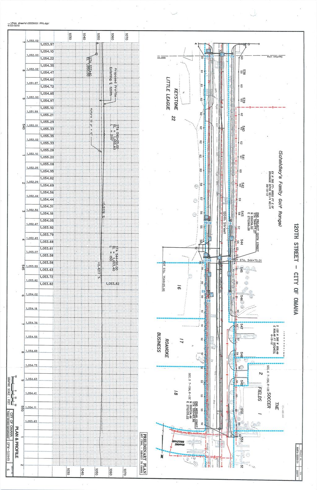
9 For example, using NAC Category B (67 dba), dba is considered an impact. Further, "substantially exceeds" is defined as 15 db(a) or more. For highway noise impact assessments, the sound level is expressed as an average hourly equivalent Leq(h) db, that has been A-weighted. Therefore, Leq(h) dba is a single number descriptor of sound that is an average of the time-varying sound level over all frequencies sensitive to humans. For a given highway geometry, traffic volume, speed, and mix respective to noise sensitive areas along the project corridor, Leq (h) dba represents the noisiest traffic hour. The viability of noise abatement measures identified in (CFR) Part 772 must be evaluated if either impact definition is met. NOISE PREDICTION METHOD Traffic Noise Model (TNM 2.5) was used to predict the Leq(h) dba noise levels at specific receptor locations. FHWA assisted in the development of TNM, approving it as the main software for noise modeling related to roadway noise projects. To process the noise levels for a specific project, numerous attributes are placed into the model. These include roadway and receptor locations and elevations, traffic volumes, traffic speed and mix, terrain features and barriers. TNM then uses this data to calculate the anticipated noise level for each receptor. The model was used to analyze noise levels for the year 2038 build and year 2038 no-build alternatives. The traffic noise levels shown in the study are predicted for peak hour noise levels and are reported in Leq(h) dba. The traffic volume used for this peak hour period is the Design Hourly Volume (DHV). The receptors used in this study, shown on the maps in Appendix A, are located at specific locations in relation to the housing units that would be the most impacted by the proposed roadway improvements. Table 1 (Appendix B) lists each receptor, the distance from each receptor to the proposed road centerline, and the computed noise levels for the future noise levels. The last column in Table 1 is the Leq(h) dba noise abatement criteria which are part of the 23 CFR Part 772 guidelines that are used in evaluating a noise impact. PROJECT DESCRIPTION The City of Omaha desires to provide an adequate network of city arterials that carry local traffic to the surrounding highway and local street network. Commercial and residential growth in the northwest portion of Omaha has significantly increased traffic volumes along the 120th Street corridor. To accommodate the growth in traffic, and to improve safety along the corridor, the City of Omaha plans to improve 120th Street from approximately 200-feet north of Stonegate Drive to Roanoke Boulevard (the Project). The Project is approximately 1-mile long and includes a bridge over the Big Papillion Creek. The City of Omaha plans to develop the project through the Nebraska Department of Roads (NDOR) and the Federal Highway Administration (FHWA). The existing roadway section north of West Maple Road along the Project corridor is a two-lane roadway with open drainage and no curb-and-gutter or sidewalks. Commercial properties border the corridor between Maple Street and Stonegate Drive, and primarily recreational areas border the corridor north of West Maple Road. Roanoke Boulevard serves as a primary exit and 5 P a g e
10 entrance to an established neighborhood and proposed commercial development. The existing segment of 120th Street, south of the Project, is a four-lane facility with sidewalks and curb and gutter. The existing segment of 120th Street north of Roanoke Boulevard to Fort Street has previously been widened to four lanes with a raised median. The intersecting roadways of West Maple Road and Fort Street are multi-lane facilities. No future projects on 120th Street are planned within the next six years north or south of this Project. Existing 120th Street from West Maple Road to Roanoke Boulevard has an existing roadway flood occurrence of years. NDOR criteria shall be reviewed to establish the best possible profile for the development of this area and the safety of the traveling public. The MAPA 2030 Long Range Transportation Plan shows 120th Street along the Project corridor as a future four-lane facility on the Street and Highway Improvements Map. Additionally, the Project is identified for fiscal year 2016 construction in MAPA s Transportation Improvement Program. The segment of 120th Street is identified on the Federal Functional Classification System as a minor arterial. Traffic Parameters The future (2038) traffic volumes were developed from MAPA s travel demand model and future turning movement counts were derived through a process using existing and future daily volumes. Project was pre-determined to be four-lane divided roadway. Additional traffic analysis confirmed turning movement configurations at the intersections of 120 th and Maple Road as well as 120 th and Emmet Street. The resulting traffic study provided the traffic parameters, including posted speed limit, Average Daily Traffic (ADT), and Design Hourly Volume (DHV) for the existing and design years for several segments of the roadway within this project. The DHV was used for the prediction of noise levels. Breaking out the truck traffic, the analysis put heavy truck traffic at 1% of the volume and medium truck traffic at 2%. Heavy trucks include vehicles that typically have three or more axles, and generally have a gross vehicle mass/weight greater than 26,000 pounds. Medium trucks typically have two axles, six wheels and generally have a gross vehicle mass/weight greater than 10,000 pounds but less than 26,000 pounds. 6 P a g e
11 The following traffic volumes were used to evaluate this project: TABLE 1: TRAFFIC VOLUMES Roadway Segment Traffic Counts 2018 Volume 2038 Volume 120th ADT 15,634 37,650 (north of Maple) DHV (All Vehicles) 1,563 3,765 2% Medium Trucks % Heavy Trucks th ADT 22,563 25,457 (south of Maple) DHV (All Vehicles) 2,256 2,546 2% Medium Trucks % Heavy Trucks Maple ADT 36,654 44,229 (west of 120th) DHV (All Vehicles) 3,5 4,423 2% Medium Trucks % Heavy Trucks Maple ADT 39,206 48,528 (east of 120th) DHV (All Vehicles) 3,921 4,853 2% Medium Trucks % Heavy Trucks DESIGN ALTERNATIVES Traffic noise levels associated with existing conditions, no-build scenario and 3 design alternatives associated with the build scenarios were predicted for this noise study and are described below: Existing: the existing design involves a two-lane facility through most of the project area. No-build: this alternative evaluates not constructing the proposed project. Centered Alignment: this alternative includes widening the roadway to a fourlane divided facility in which the proposed centerline of the widened roadway cross-section is centered on the existing roadway centerline alignment. 20-ft Left Alignment: this alternative includes widening the roadway to a four-lane divided facility in which the proposed centerline of the widened roadway crosssection is shifted 20-ft. left (or west) of the existing roadway centerline alignment. 40-ft Left Alignment: this alternative includes widening the roadway to a four-lane divided facility in which the proposed centerline of the widened roadway crosssection is shifted 40-ft. left (or west) of the existing roadway centerline alignment. The three design alternatives were evaluated in order to assess the preferred alternative from an engineering design perspective. However, due to the close similarity of the build alternatives, only two alternatives; No-build and 20-ft Left Alignment; will be considered and evaluated in the NEPA environmental evaluation of the project. 7 P a g e
12 FIELD MEASUREMENTS To check the existing noise levels against the model s results, tests were taken at three sites, separate from the 38 receptor locations and 48 receptors. These sites were added to the model and are displayed in Map 1 in Appendix B. Each site was placed in closer proximity to 120th Street than any of the other receptor locations in the nearby area. The results of each test are displayed below: TABLE 2: CHECK SITE NOISE RESULTS Modeled Noise Tested Noise Level Level (dba) (dba) Difference Check Site A Check Site B Check Site C All three check receivers tested out lower than the model predictions for receivers in the same location. Overall, the average of the three was 2.3 dba lower than the model. TRAFFIC NOISE ANALYSIS The Nebraska Department of Roads (NDOR) generally considers a noise impact exists if one of the following criteria are met or exceeded. 1. The predicted design-year noise levels approach or exceed noise abatement criteria established within 23 CFR 772. Approach is defined as 1 decibel less than the Noise Abatement Criteria (NAC) for categories A-E. 2. The predicted design-year noise levels are more than 15 decibels higher than existing noise levels. This constitutes a Substantial Increase over Existing Noise Level. A substantial noise increase is a noise impact, even if the future noise level is lower than the NAC. The existing conditions model indicated that one (1) of the 38 receptors has a noise impact that approach or exceed the noise criteria (67 dba for type B and C land uses, 72 dba for type E land uses). The noise levels for residents and businesses ranged from 51.8 to 67.4 dba. It was indicated that Receivers14 & 14A were in violation of the noise criteria (see Receivers Map, Appendix B). The results of the noise analysis are shown on Table A1, Appendix A. The 2038 no-build situation indicated that 1 of the 38 receptors have a noise impact. The noise levels in the 2038 no-build scenario ranged from 53.2 to 68.6 dba. The results of the noise analysis are shown on Table A2, Appendix A. Based on the aforementioned Criteria No. 1, the 2038-build Center Alignment scenario indicated that 2 of the subject 38 receptors would have a noise impact. The noise levels in the 2038-build Center Alignment scenario ranged from 53.5 to.1 dba. The results of the noise analysis are shown on Table A3, Appendix A. 8 P a g e
13 Based on the aforementioned Criteria No. 1, the 2038-build 20 Left Alignment scenario indicated that 2 of the subject 38 receptors (Receivers 6/6A and 14/14A) would have a noise impact. The noise levels in the 2038-build 20 Left Alignment scenario ranged from 54.3 to 69.2 dba.. The results of the noise analysis are shown on Table A4, Appendix A. Based on the aforementioned Criteria No. 1, The 2038-build 40 Left Alignment scenario indicated that 2 of the subject 38 receptors (Receivers 6/6A and 14/14A) would have a noise impact. The noise levels in the 2038-build 40 Left Alignment scenario ranged from 55.4 to 68.1 dba. The results of the noise analysis are shown on Table A5, Appendix A. The noise contours from the and dba levels of the 2038-build Center Alignment scenario, the 2038-build 20 Left and the 2038-build 40 Left Alignment scenario have been mapped out, with the resulting maps in Appendix B. NOISE ABATEMENT MEASURES Noise abatement measures must be considered where predicted levels approach or exceed the abatement criteria, or when the predicted levels substantially exceed the existing levels (157 CFR, Section ). Noise Barriers Noise barriers are a type of abatement measure in areas where the future traffic is predicted to create a noise impact. Each noise barrier must be evaluated as feasible or reasonable or the barrier will not be considered for construction. The NDOR Noise Abatement Policy (2011) was used for guidance in evaluating the feasibility and reasonableness of individual noise barriers. As provided in this policy, feasibility involves engineering considerations and is judged under the following criteria: FEASIBILITY Acoustic Feasibility - A noise abatement device is considered acoustically feasible when 60% of the front row impacted receivers located directly behind the noise wall achieves a 5 db(a) noise reduction. Other significant noise levels within the project area will not prevent acoustic feasibility as long as TNM demonstrates that a wall achieves the 5 db(a) noise reduction from traffic alone. Engineering Feasibility - The determination that it is possible to design and construct a noise abatement measure. The following items will be considered in determining Engineering feasibility: 1. Can the barrier be designed to fit the topography and still be maintained? 2. Can the exposed height of a noise barrier be built at 30 feet high or less? 3. Safety concerns: A. Can the barrier be located beyond the clear recovery zone? B. Can the barrier be incorporated into existing or designed highway barriers? If any of the feasibility items 1-3 are checked NO, the site will be considered not feasible. If the site is considered not feasible, a reasonable analysis will not be done. 9 P a g e
14 REASONABLENESS There are three reasonableness factors or "tests" that must be met for a noise abatement measure to be considered reasonable. 1. Noise reduction design goal of 7 db(a). A minimum of 40% of benefited front row receptors directly behind the noise wall (noise wall must extend entirely across benefited receptor s property line) must achieve a 7 db(a) noise reduction in order for noise abatement to be reasonable. 2. Cost Effectiveness. Noise abatement must be cost effective. NDOR defines cost effectiveness as dollars per benefited receiver. Based on construction price estimates for 2010, NDOR utilizes $44/ft2 for barrier costs. If the cost per benefited receiver is greater than $40,000, the site will be considered not reasonable. The cost of utility relocation, drainage control, and ROW acquisition will be factored into the cost effectiveness of noise abatement. Aesthetic treatment is not factored into cost. 3. Viewpoints of the property owners and residents of the benefited receptors. When it is determined that it would be feasible to provide noise abatement for a site, and a preliminary determination has been made that abatement would be reasonable, a noise abatement public informational meeting will be held as part of the process for a final determination of whether abatement would be reasonable. The benefited property owners and residents will be given an opportunity to vote in the form of a ballot vote. NDOR defines a benefited receptor as achieving at least a 5 db(a) reduction. Feasibility/Reasonableness Design Year Centered Alignment Utilizing the frontage formula for locating receptors on Category C properties as per NDOR s Noise Analysis and Abatement Policy (2011), ten places of frequent human use indicated 20 receptors that needed to be analyzed so each receptor was counted as 2 receptors for noise abatement analysis purposes. The following is a description of the proposed barrier location and an evaluation of the feasibility and/or reasonableness. The receptors are shown on the maps contained in Appendix B, showing the predicted noise levels and noise contours for the design year Location 1: The location of noise receptor numbers (Receiver 6/6A) and 14 (Receiver 14/14A) are on a ball park s bleachers facing ball fields east of 120 th Street. The bleachers for the ball field near Receiver 13 are approximately 8 feet from the proposed back of curb of the roadway under this alignment. It has been determined that this ball field would have to be purchased or moved to another location if this alignment was chosen. Due to this, construction of a noise wall at this location is not feasible. 10 P a g e
15 Feasibility/Reasonableness Design Year 20 Left Alignment The following is a description of the proposed barrier location and an evaluation of the feasibility and/or reasonableness. The receptors are shown on the maps contained in Appendix B, showing the predicted noise levels and noise contours for the design year Location 1: The location of noise receptor numbers (Receiver 6/6A) and 14 (Receiver 14/14A), are on a ball park s bleachers facing ball fields east of 120 th Street. As the ballpark is considered Activity Category C, the entire ball park would have to be analyzed for abatement. To receive a 5dBA reduction, a barrier wall would extend 1,320 feet along the western side of the ball fields, with two breaks in the wall of approximately 70 feet in length for parking lot access. The height of the wall would be 30 feet, the maximum height allowed as per NDOR standards, to obtain a 5dBA reduction for 10 of the 20 front row receptors (50.0%). As this is less than the minimum 60% required of front row receptors to meet the reduction requirement for an Acoustic Feasibility Design Goal, the construction of the wall would not be considered feasible. Feasibility/Reasonableness Design Year 40 Left Alignment The following is a description of the proposed barrier location and an evaluation of the feasibility and/or reasonableness. The receptors are shown on the maps contained in Appendix B, showing the predicted noise levels and noise contours for the design year Location 1: The location of noise receptor numbers 6 (Receiver 6/6A) and 14 (Receiver 14/14A), are on a ball park s bleachers facing ball fields east of 120 th Street. As the ballpark is considered Activity Category C, the entire ball park would have to be analyzed for abatement. To receive a 5dBA reduction, a barrier wall would extend 1,320 feet along the western side of the ball fields, with two breaks in the wall of approximately 70 feet in length for parking lot access. The height of the wall would be 30 feet to obtain a 5dBA reduction for 14 of the 20 front row receptors (70.0%). However, only 4 of the 20 front row receptors (20%) would be able to achieve a 7dBA reduction. As this is less than the minimum 40% required of front row receptors to meet the reduction requirement for the Noise Reduction Design Goal, the construction of the wall would not be considered reasonable. Earth Berms The construction of an earth berm serves as a noise barrier that can help to reduce traffic noise levels if located between the traffic noise source and the impacted receptor. Earth berms are typically a more accepted way of dealing with noise as they are effective in reducing traffic noise, but are also athletically pleasing. Earth berms were evaluated for noise barriers but are not considered feasible due to the topography and the space restrictions between the roadway and the already undersized parking lots for the ball fields. Space constraints make noise walls the only suitable noise barrier alternative. 11 P a g e
16 Buffer zones Buffer zones provide enough distance between the noise source and the impacted receptors in order to reduce noise impacts. Buffer zones are typically used in undeveloped areas where a substantial amount of right-of-way can be obtained prior to development. Most of the land along 120 th Street has been developed, making buffer zones not feasible. Alteration of Horizontal and Vertical Alignments Noise abatement measures that include the alteration of horizontal and/or vertical alignments can be incorporated to reduce traffic noise impacts where the receptors are typically on one side of the roadway or where the elevation can be adjusted. Moving the centerline away from the source may reduce the noise impacts enough to be in compliance. This was considered for 120 th Street, however the existence of receptors on both sides of the street made this alternative impractical. Traffic Management Measures The use of traffic management measures was evaluated as noise abatement measure. Traffic management may include reduced speed limits or the prohibition of certain vehicle types, mainly trucks, as a noise abatement measure. Trucks can be prohibited from certain streets or roads, or permitted to use specific streets or roads only during daylight hours. These options may not be feasible for this project since the proposed roadway will be a main trafficway for this portion of Omaha. Also the impacted uses are recreational, requiring use during daylight hours. Detour Noise Impacts Due to the proposed cut and fill operations and the need to relocate utilities, each segment of the 120th Street improvements will be constructed to provide local access, but may be closed to through traffic. Although an analysis of the routing of the through traffic has not been completed at this time, through traffic can be detoured to 108th or 132nd Streets if closure to through traffic is deemed necessary. Detour noise impacts are not anticipated to be substantial and are temporary based on the segment of 120th Street that would be under construction. 12 P a g e
17 Construction Noise Impacts In addition to the long-term traffic noise impacts, construction noise impacts need to also be considered. The noise sensitive receptors immediately adjacent to this project are of concern to the noise considerations of this project. Construction activities typically produce short-term increases in noise levels at these locations. The FHWA has created the Roadway Construction Noise Model (RCNM) to assess the impact of construction noise. As in this project, many times construction is often held within relatively close proximity to residential and commercial properties, monitoring and avoiding the most significant impacts of construction noise upon surrounding properties should be of paramount concern. Although the calculation of construction noise levels is not specifically necessary to the development of a noise study in most instances, FHWA guidance requests it for complex and controversial or major urban projects. The construction activities in this project will likely include site clearing, excavation, earth movement, paving, and the installation of signage and traffic control devices. Although work will be done within the time constraints of applicable local municipal ordinances, if any work is required during nighttime periods, all required permits would be obtained from the local municipality. These permits are likely to include conditions and restrictions on specific activities during nighttime hours to reduce the impact of construction noise on adjoining properties. To control roadway construction noise, numerous aspects will be reviewed, including but not limited to: design considerations, sequence of operations, source controls, site controls, and time and activity constraints. Additionally community awareness and the development of proper complaint mechanisms for proper resolution will also be of considered. 13 P a g e
18 TABLE 3: REFERENCE CONSTRUCTION EQUIPMENT SOUND EMISSION LEVELS (dba) Impact EL L Equipment Description max at 50 UF Usage Device? ft (dba) Factor (%) Backhoe No Bar Bender No Blasting Yes 94 NA Chain Saw No Compactor (ground) No Compressor (air) No Concrete Batch Plant No 83 NA Concrete Mixer Truck No Concrete Pump Truck No Concrete Saw No Crane No 85 NA Dozer No Drum Mixer No 80 NA Dump Truck No Excavator No Flat Bed Truck No Front End Loader No Generator No Generator (<25KVA, VMS Signs) No Grader No Grapple (on backhoe) No Impact Pile Driver Yes 95 NA Jackhammer Yes Paver No Pickup Truck No Pneumatic Tools No Pumps No Scraper No Sheers (on backhoe) No 85 NA Slurry Plant No 78 NA Slurry Trenching Machine No 82 NA Vacuum Street Sweeper No 80 NA Ventilation Fan No 85 NA Vibratory Concrete Mixer No Vibratory Pile Driver No 95 NA Welder/Torch No P a g e
19 Information for Local Officials It is important for local officials to promote noise compatible planning of undeveloped land in order to avoid future noise impacts and possible noise mitigation measures. This involves developing properties at distances from the roadway that would be beyond the noise impact contours shown on the figures in Appendix B. The undeveloped land within the noise study area is isolated to properties between Roanoke Drive and Big Papillion Creek. Table 4 illustrates that residences or receptors in Category B, C and E (refer to the FHWA Noise Abatement Criteria Table) would have a defined noise impact if they were built at or within the distances shown. Categories B and C are impacted at db(a) while category E is impacted at db(a). The distances in Table 4 were measured from the edge of pavement of the proposed roadway and calculated using 2038 traffic volumes from Roanoke Drive to Big Papillion Creek. NDOR strongly urges developers to build beyond the distances listed in Table 4 in order to avoid future noise impacts and mitigation. TABLE 4: DISTANCE TO NOISE CONTOURS Location Distance from edge of pavement to future contour (2038) db(a) contour (ft) db(a) contour (ft) West Side of 120th St - Roanoke Drive to Big Papillion Creek East Side of 120th St. - Undeveloped Land Between Roanoke Dr. and Keystone Park P a g e
20 CONCLUSIONS The existing conditions model indicated that one (1) of the 38 receptors has a noise impact that approach or exceed the noise criteria (67 dba for type B and C land uses, 72 dba for type E land uses). The noise levels for residents and businesses ranged from 51.8 to 67.4 dba. It was indicated that Receiver 14 was in violation of the noise criteria (see Receivers Map, Appendix B). The 2038 no-build situation indicated that 1 of the 38 receptors have a noise impact. The noise levels in the 2038 no-build scenario ranged from 53.2 to 68.6 dba. The 2038-build Center Alignment scenario indicated that 2 of the subject 38 receptors would have a noise impact. The noise levels in the 2038-build Center Alignment scenario ranged from 53.5 to.1 dba. A noise barrier was evaluated to be not feasible for this scenario as the bleachers for the ball park near Receivers 14/14A are approximately 8 feet from the proposed back of curb of the roadway under this alignment. It has been determined that this ball park would have to be purchased or moved to another location if this alignment was chosen. Therefore, a noise barrier is not warranted at this location. The 2038-build 20 Left Alignment scenario indicated that 2 of the subject 38 receptors (Receivers 6/6A and 14/14A) would have a noise impact. The noise levels in the 2038-build 20 Left Alignment scenario ranged from 54.3 to 69.2 dba. The height of the wall would be 30 feet, the maximum height allowed as per NDOR standards, to obtain a 5dBA reduction for 10 of the 20 front row receptors (50.0%). As this is less than the minimum 60% required of front row receptors to meet the reduction requirement for an Acoustic Feasibility Design Goal, the construction of the wall would not be considered feasible. The 2038-build 40 Left Alignment scenario indicated that 2 of the subject 38 receptors (Receivers 6/6A and 14/14A) would have a noise impact. The noise levels in the 2038-build 40 Left Alignment scenario ranged from 55.4 to 68.1 dba. The height of the wall would be 30 feet to obtain a 5dBA reduction for 14 of the 20 front row receptors (70.0%). However, only 4 of the 20 front row receptors (20%) would be able to achieve a 7dBA reduction. As this is less than the minimum 40% required of front row receptors to meet the reduction requirement for the Noise Reduction Design Goal, the construction of the wall would not be considered reasonable. Noise abatement measures including noise barriers, buffer zones, horizontal and vertical alignment, and traffic management measures were found to be not feasible and/or reasonable. Detour noise impacts are not applicable for construction of this proposed roadway. Construction noise impacts are temporary and limited to the time of the construction.. To evaluate the predicted noise impact on existing and future construction, noise contours were created of the three 2038-build scenarios. The noise contours from the and dba levels of the 2038-build Center Alignment scenario, the 2038-build 20 Left Alignment scenario and the 2038-build 40 Left Alignment scenario have been mapped out, with the resulting maps in Appendix B. GENERAL COMMENTS In the event that any changes in the nature, design, or location of the project are planned, the conclusions and recommendations contained in this report shall not be considered valid unless the changes are reviewed and the conclusions of this report are modified or verified in writing. 16 P a g e
21 BIBLIOGRAPHY 1. FHWA Traffic Noise Model (TNM) version CFR Part 772, Procedures for Abatement of Highway Traffic Noise and Construction Noise. 3. Nebraska Department of Roads, Noise Abatement Policy, FHWA, PB Sound Procedures for Measuring Highway Noise, November FHWA, RD , Highway Traffic Noise Prediction Model, December P a g e
22 APPENDIX A TABLE A1 - RESULTS OF NOISE ANALYSIS 120th STREET EXISTING NOISE LEVELS EMMET STREET TO ROANOKE BOULEVARD CITY OF OMAHA, DOUGLAS COUNTY, NEBRASKA PROJECT NO. OPW MAPA-5009(3) Existing LAeq1h Increase over existing Type Calculated Name LAeq1h Calculated Crit'n Calculated Crit'n Sub'l Inc Impact LAeq1h Receiver 1 - Business Receiver 2 - Business Receiver 3 - Mini Golf Receiver 4 - Undeveloped Receiver 5 & 5A - Ball Park Receiver 6 & 6A - Ball Park Receiver 7 & 7A - Ball Park Receiver 8 & 8A - Ball Park Receiver 9 & 9A - Ball Park Receiver 10 & 10A - Ball Park Receiver 11 & 11A - Ball Park Receiver 12 &12A - Ball Park Receiver 13 & 13A - Ball Park Receiver 14 & 14A - Ball Park Snd Lvl 67.4 Receiver 15 - Golf Course Receiver 16 - Golf Course Receiver 17 - Golf Course Receiver 18 - Golf Course Receiver 19 - Golf Course Receiver 20 - Golf Course Receiver 21 - Soccer Field Receiver 22 - Soccer Field Receiver 23 - Business Receiver 24 - Business Receiver 25 - Business Receiver 26 - Business Receiver 27 - Business Receiver 28 - Residential Receiver 29 - Residential Receiver 30 - Residential Receiver 31 - Business Receiver 32 - Business Receiver 33 - Business Receiver 34 - Business Receiver 35 - Business Receiver 36 - Business Receiver 37 - Business Receiver 38 - Business P a g e
23 TABLE A2 - RESULTS OF NOISE ANALYSIS 120th STREET 2038 NO-BUILD LEVELS EMMET STREET TO ROANOKE BOULEVARD CITY OF OMAHA, DOUGLAS COUNTY, NEBRASKA PROJECT NO. OPW MAPA-5009(3) Existing LAeq1h Increase over existing Type Calculated Name LAeq1h Calculated Crit'n Calculated Crit'n Sub'l Inc Impact LAeq1h Receiver 1 - Business Receiver 2 - Business Receiver 3 - Mini Golf Receiver 4 - Undeveloped Receiver 5 & 5A - Ball Park Receiver 6 & 6A - Ball Park Receiver 7 & 7A - Ball Park Receiver 8 & 8A - Ball Park Receiver 9 & 9A - Ball Park Receiver 10 & 10A - Ball Park Receiver 11 & 11A - Ball Park Receiver 12 &12A - Ball Park Receiver 13 & 13A - Ball Park Receiver 14 & 14A - Ball Park Snd Lvl 68.6 Receiver 15 - Golf Course Receiver 16 - Golf Course Receiver 17 - Golf Course Receiver 18 - Golf Course Receiver 19 - Golf Course Receiver 20 - Golf Course Receiver 21 - Soccer Field Receiver 22 - Soccer Field Receiver 23 - Business Receiver 24 - Business Receiver 25 - Business Receiver 26 - Business Receiver 27 - Business Receiver 28 - Residential Receiver 29 - Residential Receiver 30 - Residential Receiver 31 - Business Receiver 32 - Business Receiver 33 - Business Receiver 34 - Business Receiver 35 - Business Receiver 36 - Business Receiver 37 - Business Receiver 38 - Business P a g e
24 TABLE A3 - RESULTS OF NOISE ANALYSIS 120th STREET 2038 CENTERED ALIGNMENT LEVELS EMMET STREET TO ROANOKE BOULEVARD CITY OF OMAHA, DOUGLAS COUNTY, NEBRASKA PROJECT NO. OPW MAPA-5009(3) 2227 Existing LAeq1h Increase over existing Type Calculated Name LAeq1h Calculated Crit'n Calculated Crit'n Sub'l Inc Impact LAeq1h Receiver 1 - Business Receiver 2 - Business Receiver 3 - Mini Golf Receiver 4 - Undeveloped Receiver 5 & 5A - Ball Park Receiver 6 & 6A - Ball Park Snd Lvl.8 Receiver 7 & 7A - Ball Park Receiver 8 & 8A - Ball Park Receiver 9 & 9A - Ball Park Receiver 10 & 10A - Ball Park Receiver 11 & 11A - Ball Park Receiver 12 &12A - Ball Park Receiver 13 & 13A - Ball Park Receiver 14 & 14A - Ball Park Snd Lvl.1 Receiver 15 - Golf Course Receiver 16 - Golf Course Receiver 17 - Golf Course Receiver 18 - Golf Course Receiver 19 - Golf Course Receiver 20 - Golf Course Receiver 21 - Soccer Field Receiver 22 - Soccer Field Receiver 23 - Business Receiver 24 - Business Receiver 25 - Business Receiver 26 - Business Receiver 27 - Business Receiver 28 - Residential Receiver 29 - Residential Receiver 30 - Residential Receiver 31 - Business Receiver 32 - Business Receiver 33 - Business Receiver 34 - Business Receiver 35 - Business Receiver 36 - Business Receiver 37 - Business Receiver 38 - Business P a g e
25 TABLE A4 - RESULTS OF NOISE ANALYSIS 120th STREET LEFT ALIGNMENT LEVELS EMMET STREET TO ROANOKE BOULEVARD CITY OF OMAHA, DOUGLAS COUNTY, NEBRASKA PROJECT NO. OPW MAPA-5009(3) Existing LAeq1h Increase over existing Type Calculated Name LAeq1h Calculated Crit'n Calculated Crit'n Sub'l Inc Impact LAeq1h Receiver 1 - Business Receiver 2 - Business Receiver 3 - Mini Golf Receiver 4 - Undeveloped Receiver 5 & 5A - Ball Park Receiver 6 & 6A - Ball Park Snd Lvl.5 Receiver 7 & 7A - Ball Park Receiver 8 & 8A - Ball Park Receiver 9 & 9A - Ball Park Receiver 10 & 10A - Ball Park Receiver 11 & 11A - Ball Park Receiver 12 &12A - Ball Park Receiver 13 & 13A - Ball Park Receiver 14 & 14A - Ball Park Snd Lvl 69.2 Receiver 15 - Golf Course Receiver 16 - Golf Course Receiver 17 - Golf Course Receiver 18 - Golf Course Receiver 19 - Golf Course Receiver 20 - Golf Course Receiver 21 - Soccer Field Receiver 22 - Soccer Field Receiver 23 - Business Receiver 24 - Business Receiver 25 - Business Receiver 26 - Business Receiver 27 - Business Receiver 28 - Residential Receiver 29 - Residential Receiver 30 - Residential Receiver 31 - Business Receiver 32 - Business Receiver 33 - Business Receiver 34 - Business Receiver 35 - Business Receiver 36 - Business Receiver 37 - Business Receiver 38 - Business P a g e
26 TABLE A5 - RESULTS OF NOISE ANALYSIS 120th STREET LEFT ALIGNMENT LEVELS EMMET STREET TO ROANOKE BOULEVARD CITY OF OMAHA, DOUGLAS COUNTY, NEBRASKA PROJECT NO. OPW MAPA-5009(3) Existing LAeq1h Increase over existing Type Calculated Name LAeq1h Calculated Crit'n Calculated Crit'n Sub'l Inc Impact LAeq1h Receiver 1 - Business Receiver 2 - Business Receiver 3 - Mini Golf Receiver 4 - Undeveloped Receiver 5 & 5A - Ball Park Receiver 6 & 6A - Ball Park Snd Lvl 67.1 Receiver 7 & 7A - Ball Park Receiver 8 & 8A - Ball Park Receiver 9 & 9A - Ball Park Receiver 10 & 10A - Ball Park Receiver 11 & 11A - Ball Park Receiver 12 &12A - Ball Park Receiver 13 & 13A - Ball Park Receiver 14 & 14A - Ball Park Snd Lvl 68.1 Receiver 15 - Golf Course Receiver 16 - Golf Course Receiver 17 - Golf Course Receiver 18 - Golf Course Receiver 19 - Golf Course Receiver 20 - Golf Course Receiver 21 - Soccer Field Receiver 22 - Soccer Field Receiver 23 - Business Receiver 24 - Business Receiver 25 - Business Receiver 26 - Business Receiver 27 - Business Receiver 28 - Residential Receiver 29 - Residential Receiver 30 - Residential Receiver 31 - Business Receiver 32 - Business Receiver 33 - Business Receiver 34 - Business Receiver 35 - Business Receiver 36 - Business Receiver 37 - Business Receiver 38 - Business P a g e
27 APPENDIX B 23 P a g e
28
29 N 120th St N 118th St Roanoke Blvd Receiver 01 Receiver 02 Receiver 03 Receiver 04 Fowler Ave Receiver 05 & 5A kj Receiver 06 & 6A Receiver 07 & 7A Receiver 08 & 8A Meredith Ave Receiver 09 & 9A Receiver 10 & 10A Receiver 11 & 11A Receiver 12 & 12A Receiver 13 & 13A $+ Check Receiver A kj Receiver 14 & 14A Receiver 15 ² Figure 1: Centered Scenario - North Legend Feet 120th Street Reconstruction kj Receiver Impacted Receiver $+ Check Receiver 4/19/14 TSA Project: CAS
30 kj Receiver 14 & 14A Receiver 15 Receiver 16 Receiver 21 Receiver 17 $+ Check Receiver B Receiver 22 N 120th St Receiver 18 Receiver 19 Receiver 20 Old Maple Rd State Hwy 64 W Maple Rd ² Feet Receiver 23 Figure 02: Centered Scenario - Middle Legend 120th Street Reconstruction kj Receiver Impacted Receiver 4/19/14 TSA Project: CAS $+ Check Receiver
31 Receiver 20 Old Maple Rd W Maple Rd State Hwy 64 Receiver 23 Receiver 24 Receiver 25 Emmet St Receiver 26 Receiver 27 N 121st Plz Receiver 28 Receiver 29 Receiver 30 Receiver 31 Receiver 36 Bedford Plz $+ Check Receiver C Bedford Ave N 120th Ct Receiver 32 Receiver 37 Stonegate Dr Receiver 33 Receiver 34 Receiver 35 Spencer St N 120th St Receiver 38 Stonegate Cir ² Wirt St N 120th Ave N 118th Cir Figure 03: Centered Scenario - South Legend kj Receiver Impacted Receiver $+ Check Receiver Feet 120th Street Reconstruction 4/19/14 TSA Project: CAS
32 N 120th St N 118th St Roanoke Blvd Receiver 01 Receiver 02 Receiver 03 Receiver 04 Fowler Ave Receiver 05 & 5A kj Receiver 06 & 6A Receiver 07 & 7A Receiver 08 & 8A Receiver 09 & 9A Receiver 10 & 10A Receiver 11 & 11A Receiver 12 & 12A Receiver 13 & 13A $+ Check Receiver A kj Receiver 14 & 14A ² Receiver Figure 4: 20' Left Scenario - North Legend kj Receiver Impacted Receiver $+ Check Receiver Feet 120th Street Reconstruction 4/19/14 TSA Project: CAS
33 Tranquilty Park Rd N 118th St Receiver 09 & 9A Receiver 10 & 10A Sunburst St Receiver 11 & 11A Receiver 12 & 12A Receiver 13 & 13A N 120th St $+ Check Receiver A kj Receiver 14 & 14A Receiver 15 Sahler St Receiver 16 Sprague Cir Receiver 21 Receiver 17 Ruggles Cir N 117th St Ruggles St $+ Check Receiver B Receiver 22 Receiver 18 Receiver 19 Receiver 20 Old Maple Rd Receiver 23 W Maple Rd State Hwy 64 Emmet St N 124th St Receiver 24 Receiver 25 Receiver 26 ² Stonegate Dr Receiver Figure 05: 20' Left Scenario - Middle Legend kj Receiver Impacted Receiver $+ Check Receiver Feet 120th Street Reconstruction 4/19/14 TSA Project: CAS

34 Old Maple Rd W Maple Rd State Hwy 64!( Receiver 23!( Receiver 24!( Receiver 25 Emmet St!( Receiver 26!( Receiver 27 N 121st Plz Bedford Plz!(!(!(!( Receiver 28 Receiver 29 Receiver 30 Receiver 31!( Receiver 36 $+ Check Receiver C Spencer St Stonegate Dr N 120th Ct!(!(!(!( Receiver 32 Receiver 33 Receiver 34 Receiver 35!( Receiver 37!( Receiver 38 N 120th St Stonegate Cir ² Wirt St N 120th Ave N 118th Cir Figure 06: 20' Left Scenario - South Legend!( Receiver kj Impacted Receiver $+ Check Receiver Feet 120th Street Reconstruction 4/19/14 TSA Project: CAS
35 N 120th St N 118th St Roanoke Blvd Receiver 01 Receiver 02 Receiver 03 Receiver 04 Receiver 05 & 5A kj Receiver 06 & 6A Receiver 08 & 8A Receiver 07 & 7A Receiver 09 & 9A Receiver 10 & 10A Receiver 11 & 11A Receiver 12 & 12A Receiver 13 & 13A $+ Check Receiver A kj Receiver 14 & 14A ² Figure 7: 40' Left Scenario - North Legend kj Receiver Impacted Receiver $+ Check Receiver Feet 120th Street Reconstruction 4/19/14 TSA Project: CAS
36 kj Receiver 14 & 14A Receiver 15 Receiver 16 Receiver 21 Receiver 17 $+ Check Receiver B Receiver 22 N 120th St Receiver 18 Receiver 19 Receiver 20 Old Maple Rd ² W Maple Rd State Hwy Figure 08: 40' Left Scenario - Middle Legend kj Receiver Impacted Receiver $+ Check Receiver Feet Receiver th Street Reconstruction 4/19/14 TSA Project: CAS
37 Receiver 20 Old Maple Rd W Maple Rd State Hwy 64 Receiver 23 Receiver 24 Receiver 25 Emmet St Receiver 26 Receiver 27 N 121st Plz Receiver 28 Receiver 29 Receiver 30 Receiver 31 Receiver 36 Bedford Plz $+ Check Receiver C Bedford Ave N 120th Ct Receiver 32 Receiver 37 Stonegate Dr Receiver 33 Receiver 34 Receiver 35 Spencer St N 120th St Receiver 38 Stonegate Cir ² Wirt St N 120th Ave N 118th Cir Figure 09: 40' Left Scenario - South Legend kj Receiver Impacted Receiver $+ Check Receiver Feet 120th Street Reconstruction 4/19/14 TSA Project: CAS
38
39 Attachment 1 Page 1 of 4 Attachment 1
40 Technical Memorandum TO: Jon Meyer (City of Omaha) FROM: Schemmer SUBJECT: Noise Analysis, Traffic Volume Update for 120 th Street and West Maple Road PROJECT: 120th Street Stonegate to Fort, MAPA-5009(3) CN OPW DATE: March 13 th, 2017 Executive Summary This memo details the update to traffic volumes on 120 th Street from 2010 to 2035 MAPA model to the 2010 to 2040 MAPA model with comparisons to the volumes included with the noise analysis approved in July, The current noise analysis utilized the 2010 to 2035 MAPA model and projected growth for 2018 and MAPA released the 2040 model in As part of this memo, the 2040 projected volumes are further refined with turning movement counts collected by the City of Omaha in Existing Traffic Counts Metro Area Planning Organization (MAPA) provided the previous 2010 and 2035 traffic volumes for the intersection of 120 th Street and West Maple Road. The 2035 MAPA model is the basis of the current noise analysis using average annual growth volumes for 2018 and The City conducted intersection turning movement counts (TMC) at the study intersection on a typical weekday in December, The 2013 average daily traffic volumes (ADT) are shown in Table 1 for comparison to MAPA 2010 base model volumes and noise analysis, Table 1 traffic volumes. Table 1. Existing ADT MAPA and TMC Location (base model) TMC Noise Study 120 th Street, North of West Maple Road 11,000 13,300 15, th Street, South of West Maple Road 21,500 22,800 22,563 West Maple Road, West of 120 th Street 34,000 39,500 36,654 West Maple Road, East of 120 th Street 36,000 40,700 39, Traffic Projections In spring 2014, MAPA released the latest update to its travel demand model (TDM) that includes the 2040 traffic forecast. The 2040 projections are lower for 120 th Street north of West Maple and higher for the south, east, and west approaches as compared with the 2035 projections, which are shown in Table 2, along with the 2010 ADT Page 2 of 4 Attachment 1
41 that was used in MAPA s base model. Table 2. MAPA TDM ADT Projection Comparison 2010 Location (base model) 2035 (projection) 2040 (projection) 120 th Street, North of West Maple Road 11,000 33,000 19, th Street, South of West Maple Road 21,500 25,000 25,000 West Maple Road, West of 120 th Street 34,000 43,000 47,000 West Maple Road, East of 120 th Street 36,000 47,000 48,000 The differences between the 2035 and 2040 traffic projections arise from many factors. MAPA is using updated technology and software for the land planning aspect of the TDM inputs, which relies on more accurate land use data than MAPA s previous land use model, and therefore produces improved traffic projections. The actual travel demand modeling software itself remains the same (TransCAD). Additionally, the roadway network in the 2040 TDM was updated to reflect the current MAPA Transportation Plan, which (among other improvements) reflects widening West Maple Road from 4-lanes to a 6-lanes and revised land use and growth along 120 th Street north of West Maple Road. 3.0 Future Traffic Volumes Based on MAPA s 2010 and 2035 volumes, the noise analysis used the average annual growth rate to project 2038 volumes, which are shown in Table 3. Table 3. Year 2010, 2035, 2038 (Extrapolated) ADT Comparison Location th Street, North of West Maple Road 11,000 33,000 37, th Street, South of West Maple Road 21,500 25,000 25,457 West Maple Road, West of 120 th Street 34,000 43,000 44,229 West Maple Road, East of 120 th Street 36,000 47,000 48,528 Based on MAPA s 2010 and 2040 volumes, an interpolated growth rate was calculated to project annual growth. The calculated annual growth rate from the MAPA 2010 to 2040 model was applied to the City of Omaha 2013 ADT from turning movement counts for the intersection of 120 th Street and West Maple Road to project 2040 ADT which are shown in Table 4. Page 3 of 4 Attachment 1
42 Table 4. Year 2013 ADT from TMC, 2040 ADT Projection 2013 Location City Counts 2040 (projection) 120 th Street, North of West Maple Road 13,300 20, th Street, South of West Maple Road 22,800 26,300 West Maple Road, West of 120 th Street 39,500 50,600 West Maple Road, East of 120 th Street 40,700 53, Conclusions The 2038 ADT projections from Table 3 were compared to the 2040 ADT projections from Table 4, and are shown in Table 5. Table 5. Year 2013, 2038, and 2040 ADT Comparison (calculated from peak hour volume) Location 2013 City Counts 2038 Noise Analysis 2040 (projection) % Change 2038 to th Street, North of West Maple Road 13,300 37,650 20,600-55% 120 th Street, South of West Maple Road 22,800 25,457 26, % West Maple Road, West of 120 th Street 39,500 44,229 50, % West Maple Road, East of 120 th Street 40,700 48,528 53, % When considering the effects on traffic noise resulting from an increase or decrease in traffic volumes, a doubling (+100% change) or halving (-50% change) is required to produce a ±3 dba difference, which is the minimum perceptible difference to human ears. Comparing the 2038 ADT projections to the 2040 ADT projections, the maximum percent increase is approximately 14% while a decline of 55% is projected for north of West Maple Road. The noise analysis approved in July, 2015 indicated abatement measures were found to be not feasible or reasonable. The amount of change on 120 th Street north of West Maple is greater than the 25% change stipulated by NDOR for a re-evaluation of noise impacts, however, the reduction in volume would reduce noise. Thus, the updated volumes would not significantly change the findings of the noise analysis. As a result, the current findings of the noise analysis should be considered valid. Page 4 of 4 Attachment 1
43
Appendix B: Noise Study
 Appendix B: Noise Study creating remarkable solutions for a higher quality of life NOISE STUDY Interstate 55 Route PP to County Road 311 Prepared for: MoDOT PROJECT NO. J010956 November 2014 Prepared
Appendix L Noise Technical Report. Rehabilitation and Restoration of the Longfellow Bridge
 Appendix L Noise Technical Report Rehabilitation and Restoration of the Longfellow Bridge Noise Technical Report Rehabilitation and Restoration of the Longfellow Bridge Boston, MA May, 2011* Prepared by
Memorandum 1.0 Highway Traffic Noise
 Memorandum Date: September 18, 2009 To: Chris Hiniker, SEH From: Stephen B. Platisha, P.E. Re: Updated CSAH 14 Noise Analysis The purpose of this memorandum is to provide the results of the revised traffic
Appendix D. Traffic Noise Analysis Report. I-94 St. Michael to Albertville Minnesota Department of Transportation
 Appendix D Traffic Noise Analysis Report I-94 St. Michael to Albertville Minnesota Department of Transportation Traffic Noise Analysis Report I-94 St. Michael to Albertville Project SP 8680-172 Report
Noise Impact Analysis. NW Bethany Boulevard Improvement Project NW Bronson Road to NW West Union Road. November Washington County.
 Noise Impact Analysis NW Bethany Boulevard Improvement Project NW Bronson Road to NW West Union Road Washington County November 2011 Prepared for: Washington County Department of Land Use and Transportation
Traffic Noise and Vibration Impact Assessment Technical Report for the North Meadows Extension to US 85 and Interstate 25
 Traffic Noise and Vibration Impact Assessment Technical Report for the North Meadows Extension to US 85 and Interstate 25 February 2010 Prepared for: Town of Castle Rock Douglas County Colorado Department
APPENDIX Q MSP 2020 Improvements EA Traffic Noise Proposed Roadway Improvements Memorandum
 APPENDIX Q MSP 2020 Improvements EA Traffic Noise Proposed Roadway Improvements Memorandum This page is left intentionally blank. SRF No. 0107343 MEMORANDUM TO: FROM: Brandon Bourdon, P.E. Kimley-Horn
Noise Mitigation Study Pilot Program Summary Report Contract No
 Ohio Turnpike Commission Noise Mitigation Study Pilot Program Summary Report Contract No. 71-08-02 Prepared For: Ohio Turnpike Commission 682 Prospect Street Berea, Ohio 44017 Prepared By: November 2009
Environmental Noise Assessment Pa ia Relief Route Project Pa ia, Maui County, Hawaii
 Environmental Noise Assessment Pa ia Relief Route Project Pa ia, Maui County, Hawaii June 2018 DLAA Project No. 08-04B Prepared for: SSFM International, Inc. Honolulu, Hawaii Section TABLE OF CONTENTS
WITHIN GENERATOR APPLICATIONS
 POWER SYSTEMS TOPICS 9 Measuring and Understanding Sound WITHIN GENERATOR APPLICATIONS INTRODUCTION When selecting a generator, there are many factors to consider so as not to negatively impact the existing
Virginia Avenue Tunnel (VAT) Reconstruction Noise Analysis Approach
 Reconstruction Noise Analysis Approach") Virginia Avenue Tunnel (VAT) Reconstruction Noise Analysis Approach Richard K. Nath CSX, REM, CESM & CSIP Ahmed A. El-Aassar, Ph.D., P.E. Gannett Fleming Inc. Railroad Environmental Conference University
Virginia Avenue Tunnel (VAT) Reconstruction Noise Analysis Approach Richard K. Nath CSX, REM, CESM & CSIP Ahmed A. El-Aassar, Ph.D., P.E. Gannett Fleming Inc. Railroad Environmental Conference University
FINAL REPORT. On Project Supplemental Guidance on the Application of FHWA s Traffic Noise Model (TNM) APPENDIX K Parallel Barriers
 APPENDIX K Parallel Barriers") FINAL REPORT On Project - Supplemental Guidance on the Application of FHWA s Traffic Noise Model (TNM) APPENDIX K Parallel Barriers Prepared for: National Cooperative Highway Research Program (NCHRP) Transportation
FINAL REPORT On Project - Supplemental Guidance on the Application of FHWA s Traffic Noise Model (TNM) APPENDIX K Parallel Barriers Prepared for: National Cooperative Highway Research Program (NCHRP) Transportation
Appendix D: Preliminary Noise Evaluation
 Appendix D: Preliminary Noise Evaluation Acoustics The study of sound and its properties is known as acoustics. By considering basic physical properties of sound and the acoustic environment, the potential
Noise Study Report. Addendum. Interstate 10 Corridor Project. In the Counties of San Bernardino and Los Angeles
 Interstate 10 Corridor Project Draft NSR Addendum Noise Study Report Addendum Interstate 10 Corridor Project In the Counties of San Bernardino and Los Angeles 07-LA-10 PM 44.9/48.3 08-SBD-10 PM 0.0/R37.0
WesPac Pittsburg Energy Infrastructure Project. Noise Assessment Report
 WesPac Pittsburg Energy Infrastructure Project Noise Assessment Report Prepared for WesPac Energy Pittsburg LLC And Oiltanking North America LLC Prepared by TRC 1200 Wall Street West, 2 nd Floor Lyndhurst,
King Mill Lambert DRI# 2035 Henry County, Georgia
 Transportation Analysis King Mill Lambert DRI# 2035 Henry County, Georgia Prepared for: The Alter Group, Ltd. Prepared by: Kimley-Horn and Associates, Inc. Norcross, GA Kimley-Horn and Associates, Inc.
Noise Abatement Design Study Report Dulles Loop Project (Route 606 and Loudoun County Parkway) UPC 97529
 UPC 97529") CNE A Description: CNE A Proposed Barriers A1, A2, A3 Common Noise Environment (CNE) A is located along in the northern portion of the study area and is comprised of single-family homes in the Loudoun
CNE A Description: CNE A Proposed Barriers A1, A2, A3 Common Noise Environment (CNE) A is located along in the northern portion of the study area and is comprised of single-family homes in the Loudoun
PROPOSED MARYWOOD DEVELOPMENT
 ACOUSTICAL ANALYSIS PROPOSED MARYWOOD DEVELOPMENT CITY OF ORANGE, CALIFORNIA PREPARED FOR VCS Environmental 30900 RANCH VIEJO ROAD, SUITE 100 SAN JUAN CAPISTRANO, CALIFORNIA 92675 PREPARED BY A/E Tech
Session 8 Traffic Noise Modeling: Best Practices for Modeling and Review of Models
 Session 8 Traffic Noise Modeling: Best Practices for Modeling and Review of Models Facilitator: Tom Hanf, Michigan DOT Participants: Mark Ferroni, FHWA Josh Kozlowski, Virginia DOT Jim Ozment, Tennessee
FORT WORTH DISTRICT. SH 360 Corridor Noise Workshop Andy Kissig, P.E.
 Note: Only adjacent property owners may submit a ballot to vote on the proposed noise barrier. FORT WORTH DISTRICT SH 360 Corridor Noise Workshop Andy Kissig, P.E. November 10, 2016 What is the Purpose
Q. Will prevailing winds and wind speeds be taken into account in the noise study?
 Anthony Henday Noise Study Questions asked at Open House (October 24, 2016) March 2, 2017 Q. Will prevailing winds and wind speeds be taken into account in the noise study? Yes, engineers will review weather
Bancroft & Piedmont Cellular Facility
 Page 1 of 19 Environmental Noise Analysis Bancroft & Piedmont Cellular Facility Berkeley, California BAC Job # 2015-177 Prepared For: Complete Wireless Consulting Attn: Ms. Kim Le 2009 V Street Sacramento,
Exit 61 I-90 Interchange Modification Justification Study
 Exit 61 I-90 Interchange Modification Justification Study Introduction Exit 61 is a diamond interchange providing the connection between Elk Vale Road and I-90. Figure 1 shows the location of Exit 61.
UC Berkeley Northside Relocation Cellular Facility
 Page 1 of 19 Environmental Noise Analysis UC Berkeley Northside Relocation Cellular Facility Berkeley, California BAC Job # 2015-290 Prepared For: Complete Wireless Consulting Attn: Kim Le 2009 V Street
APPENDIX M NOISE ANALYSIS
 APPENDIX M NOISE ANALYSIS McCORMICK RANKIN CORPORATION 2655 North Sheridan Way, Suite 300 Mississauga, Ontario, L5K 2P8 Tel: (905)823-8500 Fax: (905) 823-8503 E-mail: mrc@mrc.ca Website: www.mrc.ca MEMO
Noise Impact Analysis
 November 12, 2014 Holly P. Smyth, AICP, Planning Director City of Hercules 111 Civic Drive Hercules, CA 94547 Subject: CEQA Noise Analysis for the Proposed Sycamore Crossing Project in Hercules, California
Noise walls Some Noise Facts
 What is noise? Noise is unwanted sound. Noise is perceived differently by every individual. A noise that is irritating one person may be tolerant to another. Sound is transmitted by pressure variations
CALGARY SOUTHEAST STONEY TRAIL Detailed Design 17th Avenue SE to Macleod Trail South (Hwy 2A) Calgary, Alberta
 Calgary, Alberta") CALGARY SOUTHEAST STONEY TRAIL Detailed Design 17th Avenue SE to Macleod Trail South (Hwy 2A) Calgary, Alberta NOISE REPORT Prepared for: Alberta Infrastructure and Transportation 2 nd Floor, Twin Atria
CALGARY SOUTHEAST STONEY TRAIL Detailed Design 17th Avenue SE to Macleod Trail South (Hwy 2A) Calgary, Alberta NOISE REPORT Prepared for: Alberta Infrastructure and Transportation 2 nd Floor, Twin Atria
2.8 NOISE. Chapter IX 2. Comments and Responses CONSTRUCTION NOISE. Comment
 2.8 NOISE 2.8.1 CONSTRUCTION NOISE The noise impacts are not adequately addressed or studied in the DEIR, as there appears to be no analysis at all of potential noise level increases as measured from locations
CITY OF PINE CITY SMALL WIRELESS FACILITY DESIGN GUIDELINES
 CITY OF PINE CITY SMALL WIRELESS FACILITY DESIGN GUIDELINES I. PURPOSE AND COMPLIANCE In implementing City Code, Chapter 8, Section 815, the City Council of the City of Pine City (the City ) finds that
The Shoppes at Forney Crossings
 F M 548 U.S. HWY 80 U.S. HWY 80 F M 688 F M 548 COOL SPRINGS F M 1641 F M 548 TROPHY BUGLE CALL PHESANT WHITE PORCH SPINAKER The Shoppes at Forney Crossings 18' 14'-8" 18' 15'-8 1 2 " 14' 7' 23'-0" 21'-0"
State Road A1A North Bridge over ICWW Bridge
 Final Report State Road A1A North Bridge over ICWW Bridge Draft Design Traffic Technical Memorandum Contract Number: C-9H13 TWO 5 - Financial Project ID 249911-2-22-01 March 2016 Prepared for: Florida
APPENDIX F NOISE IMPACT AND VIBRATION ANALYSIS. City of Los Angeles, Bureau of Engineering
 APPENDIX F NOISE IMPACT AND VIBRATION ANALYSIS City of Los Angeles, Bureau of Engineering Draft EIR State Clearinghouse No. 2013011012 NOISE IMPACT AND VIBRATION ANALYSIS GRIFFITH PARK CRYSTAL SPRINGS
Survey Data and TOPO Checklist
 Checklists Survey Data and TOPO Preliminary Plan Field Review Plans o Field Review Erosion Control Right-of-Way and Utility Meeting Plans Final Plan Field Review Plans Methods of Plan Markups Plan-in-Hand
PENSACOLA BAY BRIDGE PROJECT DEVELOPMENT AND ENVIRONMENT (PD&E) STUDY. Noise Study Report. SR 30 (US 98) From 17th Avenue To Baybridge Drive
 STUDY. Noise Study Report. SR 30 (US 98) From 17th Avenue To Baybridge Drive") PENSACOLA BAY BRIDGE PROJECT DEVELOPMENT AND ENVIRONMENT (PD&E) STUDY SR 30 (US 98) From 17th Avenue To Baybridge Drive Escambia and Santa Rosa Counties, Florida Financial Project ID No. 409334-1 Federal
PENSACOLA BAY BRIDGE PROJECT DEVELOPMENT AND ENVIRONMENT (PD&E) STUDY SR 30 (US 98) From 17th Avenue To Baybridge Drive Escambia and Santa Rosa Counties, Florida Financial Project ID No. 409334-1 Federal
Public School Facilities Element
 Public School Facilities Element GOAL 1: THROUGH PARTNERSHIPS AND EFFECTIVE COLLABORATION AMONG LOCAL GOVERNMENTS AND THE PINELLAS COUNTY SCHOOL DISTRICT, AND BECAUSE OF A SHARED COMMITMENT TO EDUCATIONAL
CHAPTER 14: TRAFFIC SIGNAL STANDARDS Introduction and Goals Administration Standards Standard Attachments 14.
 14.00 Introduction and Goals 14.01 Administration 14.02 Standards 14.03 Standard Attachments 14.1 14.00 INTRODUCTION AND GOALS The purpose of this chapter is to outline the City s review process for traffic
FINAL REPORT. On Project Supplemental Guidance on the Application of FHWA s Traffic Noise Model (TNM)
") FINAL REPORT On Project 25-34 Supplemental Guidance on the Application of FHWA s Traffic Noise Model (TNM) APPENDIX A Structure Reflected Noise and Expansion Joint Noise Prepared for: National Cooperative
FINAL REPORT On Project 25-34 Supplemental Guidance on the Application of FHWA s Traffic Noise Model (TNM) APPENDIX A Structure Reflected Noise and Expansion Joint Noise Prepared for: National Cooperative
580 - NOISE BARRIERS OPSS 580 INDEX
 580 - OPSS 580 INDEX 580.1 GENERAL 580.1.1 Noise Barrier Design Elements 580.1.1.1 Wind-Load Designs 580.1.1.2 Sound-Absorptive Barriers 580.1.1.3 Noise Barrier Colour, Pattern and Texture 580.1.2 Grading
City of San José, California CITY COUNCIL POLICY
 City of San José, California CITY COUNCIL POLICY TITLE 1 1 of 6 EFFECTIVE DATE 1/22/91 REVISED DATE 9/16/03 APPROVED BY Council Action - January 22, 1991; August 11, 1992; August 20, 1996 (9d); September
Fundamentals of Environmental Noise Monitoring CENAC
 Fundamentals of Environmental Noise Monitoring CENAC Dr. Colin Novak Akoustik Engineering Limited April 03, 2013 Akoustik Engineering Limited Akoustik Engineering Limited is the sales and technical representative
A. INTRODUCTION B. METHODOLOGY
 Chapter 9: and Vibration A. INTRODUCTION This chapter analyzes the effects of Alternatives B, C, and Preferred Alternative D on ambient noise and vibration levels. can be generated by fixed facilities,
CHAPTER 2 SUBMITTAL AND REVIEW PROCEDURES TABLE OF CONTENTS
 CHAPTER 2 SUBMITTAL AND REVIEW PROCEDURES TABLE OF CONTENTS Section Title Page 2.1 General... 2-1 2.1.1 General Submittal Criteria and Procedures...2-1 2.1.2 Authorization/Certification...2-1 A. Designer
Attachment #2 PPW133-07
 Attachment #2 PPW133-07 Pg. 1 EXECUTIVE SUMMARY Environmental Assessment Study In January 2005, Regional staff retained to commence a Schedule C Environmental Assessment Study to identify the improvements
Portable Noise Monitoring Report March 5 - April 24, 2016 The Museum of Vancouver. Vancouver Airport Authority
 Portable Noise Monitoring Report March 5 - April 24, 2016 The Museum of Vancouver Vancouver Airport Authority September 27, 2016 Table of Contents INTRODUCTION... 2 OBJECTIVES... 2 VANCOUVER: AIRCRAFT
50.24 Type, Size and Location Plans for Culverts, Bridges and Culvert Bridges
 50.24 Culverts, Bridges and Culvert Bridges Type, Size and Location (T, S & L) Plans shall be required for all Bridges, Culvert Bridges and Culverts of eight-foot (8') clear span or greater as follows:
AMERICAN UNIVERSITY EAST CAMPUS DEVELOPMENT WASHINGTON, D.C. Environmental Noise Study. Project Number
 AMERICAN UNIVERSITY EAST CAMPUS DEVELOPMENT WASHINGTON, D.C. Environmental Noise Study Project Number 11-107 Douglas P. Koehn, M.S. Senior Consultant 12040 SOUTH LAKES DRIVE, SUITE 104, RESTON, VIRGINIA
Article 4.0 Measurements and Exceptions
 This Article identifies and explains some of the more common forms of measurement used throughout this Ordinance. It also specifies exceptions to certain requirements of this Ordinance. Sec. 4.1 Measurements
Plan Preparation Checklist
 Appendix D Plan Preparation Checklist It is the responsibility of the Designer to complete and submit this checklist along with all required drawings for OUC (EFP) Review. All drawings submitted for OUC
CITY OF LA MARQUE CHAPTER GRAPHIC REQUIREMENTS CONSTRUCTION PLAN AND MISCELLANEOUS REQUIREMENTS
 CITY OF LA MARQUE CHAPTER 2 -------------------------------------------- GRAPHIC REQUIREMENTS CONSTRUCTION PLAN AND MISCELLANEOUS REQUIREMENTS CHAPTER 2 ------------------------------------------------
CONCEPT REVIEW GUIDELINES
 Department of Planning & Community Development @ Jefferson Station 1526 E. Forrest Avenue Suite 100 East Point, GA 30344 404.270.7212 (Phone) 404.765.2784 (Fax) www.eastpointcity.org CONCEPT REVIEW GUIDELINES
Subdivision Application Checklist
 City of Portsmouth, New Hampshire Subdivision Application Checklist This subdivision application checklist is a tool designed to assist the applicant in the planning process and for preparing the application
Further Comparison of Traffic Noise Predictions Using the CadnaA and SoundPLAN Noise Prediction Models
 Proceedings of 20 th International Congress on Acoustics, ICA 2010 23-27 August 2010, Sydney, Australia Further Comparison of Traffic Noise Predictions Using the CadnaA and SoundPLAN Noise Prediction Models
FARM TO MARKET 1103 OPEN HOUSE PUBLIC MEETING. FM 1103 I-35 to Rodeo Dr
 FARM TO MARKET 1103 OPEN HOUSE PUBLIC MEETING March 29, 2016 FM 1103 FROM: I-35 TO: RODEO DR COMAL & GUADALUPE COUNTY OPEN HOUSE PUBLIC MEETING March 29, 2016 5:00 p.m. 7:00 p.m. Barbara C Jordan Intermediate
ACOUSTIC BARRIER FOR TRANSFORMER NOISE. Ruisen Ming. SVT Engineering Consultants, Leederville, WA 6007, Australia
 ICSV14 Cairns Australia 9-12 July, 2007 ACOUSTIC BARRIER FOR TRANSFORMER NOISE Ruisen Ming SVT Engineering Consultants, Leederville, WA 6007, Australia Roy.Ming@svt.com.au Abstract In this paper, an acoustic
Site Plan Review Application. Interest in the Property (e.g. fee simple, land option, etc.)
") 1. Identification CITY OF FENTON 301 South Leroy Street Fenton, Michigan 48430-2196 (810) 629-2261 FAX (810) 629-2004 Site Plan Review Application Project Name Applicant Name Address City/State/Zip Phone
1. Identification CITY OF FENTON 301 South Leroy Street Fenton, Michigan 48430-2196 (810) 629-2261 FAX (810) 629-2004 Site Plan Review Application Project Name Applicant Name Address City/State/Zip Phone
Charlton/Oxford Route 20 Reconstruction Project
 Public Informational Meeting February 1, 2017 Oxford High School Charlton/Oxford Route 20 Reconstruction Project Project File No. 602659 2014 HDR, Inc., all rights reserved. Public Informational Meeting
CITY OF DOVER PROPOSED ORDINANCE #
 FIRST READING CITY OF DOVER PROPOSED ORDINANCE #2016-24 1 BE IT ORDAINED BY THE MAYOR AND COUNCIL OF THE CITY OF DOVER, IN 2 COUNCIL MET: 3 That Appendix B - Zoning, Article 3 - District Regulations, Section
Noise Measurement Handbook
 FHWA-HEP-18-065 FINAL REPORT 6.1.2018 Notice This document is disseminated under the sponsorship of the U.S. Department of Transportation (USDOT) in the interest of information exchange. The U.S. Government
CHECKLIST PRELIMINARY SUBDIVISION AND PRELIMINARY SITE PLAN
 N/A Waiver (1) Four (4) copies of application form. (2) Fifteen (15) copies of plan (3) Subdivision/site plan application fee & professional review escrow deposit (4) Variance application fee & professional
CHAPTER 26 SITE PLAN REVIEW
 CHAPTER 26 SITE PLAN REVIEW Section 26.1. Committee. The Planning Commission shall appoint three members of the Planning Commission to the site plan review committee which shall be responsible for site
SITE PLAN APPLICATION
 SITE PLAN APPLICATION SECTION 1. APPLICANT/OWNER INFORMATION Please Print or Type Applicant/Developer: City: State: Zip: Telephone: Fax: E-mail: Applicant s Status: (Check One) Owner Tenant Prospective
Assessment of rail noise based on generic shape of the pass-by time history
 Proceedings of Acoustics 23 Victor Harbor 7-2 November 23, Victor Harbor, Australia Assessment of rail noise based on generic shape of the pass-by time history Valeri V. enchine, Jonathan Song Science
Appendix N. Preliminary Noise Assessment Technical Memorandum
 Appendix N Preliminary Noise Assessment Technical Memorandum SENES Consultants Limited MEMORANDUM 121 Granton Drive, Unit 12 Richmond Hill, Ontario Canada L4B 3N4 Tel: (905) 764-9380 Fax: (905) 764-9386
BASELINE NOISE MONITORING SURVEY
 t m s environment ltd TMS Environment Ltd 53 Broomhill Drive Tallaght Dublin 24 Phone: +353-1-4626710 Fax: +353-1-4626714 Web: www.tmsenv.ie BASELINE NOISE MONITORING SURVEY UNIVERSITY COLLEGE DUBLIN Report
Effectiveness of Traffic Noise Barrier on I 471 in Campbell County, Kentucky (Interim Report)
") Transportation Kentucky Transportation Center Research Report University of Kentucky Year 1984 Effectiveness of Traffic Noise Barrier on I 471 in Campbell County, Kentucky (Interim Report) Tom Creasey
Transportation Kentucky Transportation Center Research Report University of Kentucky Year 1984 Effectiveness of Traffic Noise Barrier on I 471 in Campbell County, Kentucky (Interim Report) Tom Creasey
Maintenance of Traffic sequence of operations including any phasing and detour maps;
 All Local-let projects are required to have a Stage 2 submittal to the LPA Manager for review. The only exceptions are 2-lane resurfacing, striping, guardrail, and raised pavement markers, unless otherwise
Site Plan/Building Permit Review
 Part 6 Site Plan/Building Permit Review 1.6.01 When Site Plan Review Applies 1.6.02 Optional Pre- Application Site Plan/Building Permit Review (hereafter referred to as Site Plan Review) shall be required
City of Hamilton INFORMATION FOR CONDITIONAL USE PERMIT
 City of Hamilton INFORMATION FOR CONDITIONAL USE PERMIT There is a $200.00 non-refundable fee for each request. Requests must be completed and submitted to the Public Works Department, City of Hamilton,
CHAPTER 48 NOISE POLLUTION
 CHAPTER 48 NOISE POLLUTION 48.01 Purpose 48.06 Sound Equipment and Amplifying Equipment 48.02 Definitions 48.07 Use of Sound Equipment for Commercial 48.03 Application Advertising Prohibited 48.04 Maximum
Chapter 24 Outdoor Lighting Ordinance
 Chapter 24 Outdoor Lighting Ordinance Section 10:24:1 Section 10:24:2 Section 10:24:3 Section 10:24:4 Section 10:24:5 Section 10:24:6 Section 10:24:7 Section 10:24:8 Purpose Scope and Applicability Conformances
CHAPTER 2C - PRELIMINARY DESIGN. General... 2C-1. Review of Work Load... 2C-2 Establishing Priorities... 2C-2
 SECTION 2C - 1 - PROJECT REVIEW CHAPTER 2C - PRELIMINARY DESIGN General... 2C-1 SECTION 2C - 2 - COORDINATING TIME SCHEDULES Review of Work Load... 2C-2 Establishing Priorities... 2C-2 SECTION 2C 3 - REVIEW
Appendix CANADA / Québec Montréal tunnels Ville-Marie & Viger
 PIARC WG5 Complex Underground Road Networks Part A Case Studies - appendices Appendix 3.1 - CANADA / Québec Montréal tunnels Ville-Marie & Viger 1. SUMMARY The Ville-Marie and Viger tunnel complex is part
Assured Monitoring Group
 Assured Monitoring Group YARRANLEA SOLAR FARM NOISE & VIBRATION IMPACT ASSESSMENT JANUARY 2017 I3 CONSULTING PTY LTD Project ID. 10734 R_1 DATE OF RELEASE: 15/02/2017 Table 1: Document approval Name Position
Objective 3.1: Provide or stimulate provision by the private sector of affordable housing units.
 3. HOUSING ELEMENT The purpose of this element is to provide plans and policies that will assist the City in meeting identified or projected deficits in the supply of housing, correcting substandard or
Guide Sign Policy for Secondary State Highways Edition
 Massachusetts Highway Department, Ten Park Plaza, Boston, MA 02116-3973 ` Guide Sign Policy for Secondary State Highways 2005 Edition Revised September 2005 1. PURPOSE The Massachusetts Highway Department
PURPLE LINE EXTENSION SECTION 2 AMBIENT NOISE LEVEL REPORT METRO PROJECT RODEO STATION
 PURPLE LINE EXTENSION SECTION 2 AMBIENT NOISE LEVEL REPORT METRO PROJECT 865522 RODEO STATION Kleinfelder Section Table of Contents 1.0 Introduction... 4 2.0 Noise Measurement Procedure... 4 3.0 Noise
Oakland International Airport Master Plan Update
 Oakland International Airport Master Plan Update - 200. Community-Requested Environmental Projects Port staff asked members of the Stakeholder Advisory Committee to consider any environmentally beneficial
HAMILTON TOWNSHIP Department of Planning and Zoning Application for a Commercial / Industrial Site Plan Review
 HAMILTON TOWNSHIP Department of Planning and Zoning Application for a Commercial / Industrial Site Plan Review Date: Application is hereby made for a Site Plan Review for a commercial or industrial use.
NOISE IMPACT STUDY. Benton Boarding and Daycare 5673 Fourth Line Road Ottawa, Ontario City of Ottawa File No. D
 NOISE IMPACT STUDY Benton Boarding and Daycare 5673 Fourth Line Road Ottawa, Ontario City of Ottawa File No. D07-12-13-0024 Page 2 of 23 TABLE OF CONTENTS 1.0 INTRODUCTION / BACKGROUND INFORMATION...6
Appendix F Noise and Vibration
 1.1 Wayside Noise Model Methods Wayside noise collectively refers to noise generated by railcars and locomotives (i.e., without including horn noise). The joint lead agencies used noise measurements from
APPENDIX C NOISE ANALYSIS METHODS AND CALCULATIONS
 APPENDIX C NOISE ANALYSIS METHODS AND CALCULATIONS LA-RICS LTE System Final Environmental Assessment Appendix C NOISE ANALYSIS METHODS AND CALCULATIONS This appendix presents the methods and results for
Bloomington, MN Code of Ordinances
 Bloomington, MN Code of Ordinances SEC. 19.33. INDUSTRIAL (I-1, I-2, and I-3) DISTRICTS. (a) Purpose - to preserve zones primarily for industrial use and to allow business uses in them only when necessary
HIGHWAY WORK ZONE DATA COLLECTION INSTRUMENT
 HIGHWAY WORK ZONE DATA COLLECTION INSTRUMENT Case ID: MI Date of Investigation Respondent Employer Information 1. Is the employer the primary contractor or a subcontractor working at the site? Victim Information
INTENT An Administrative Site Plan is required for the following situations, excluding single-family detached development:
 SECTION 13-400 ADMINISTRATIVE SITE PLAN 13-401 INTENT An Administrative Site Plan is required for the following situations, excluding single-family detached development: A. All development on vacant land
TECHNICAL REPORT 2016 IEL ENVIRONMENTAL NOISE SURVEY OF THE DAIRYGOLD CASTLEFARM FACILITY, MITCHELSTOWN, CO. CORK.
 TECHNICAL REPORT 16 IEL ENVIRONMENTAL NOISE SURVEY OF THE DAIRYGOLD CASTLEFARM FACILITY, MITCHELSTOWN, CO. CORK. FOR Gabriel Kelly Group Environmental Manager Dairygold Food ingredients Castlefarm Mitchelstown
ON USING PERFECT SIGNAL PROGRESSION AS THE BASIS FOR ARTERIAL DESIGN: A NEW PERSPECTIVE
 ON USING PERFECT SIGNAL PROGRESSION AS THE BASIS FOR ARTERIAL DESIGN: A NEW PERSPECTIVE Samuel J. Leckrone, P.E., Corresponding Author Virginia Department of Transportation Commerce Rd., Staunton, VA,
# Insite RE Inc./ Verizon Wireless Special Use Permit Project Review for Planning and Zoning Commission
 #2015-52 Insite RE Inc./ Verizon Wireless Special Use Permit Project Review for Planning and Zoning Commission Meeting Date: October 21, 2015 Request: Location: A Special Use Permit for a wireless communication
SECTION 100 PRELIMINARY CONSIDERATIONS & INSTRUCTIONS
 SECTION 100 PRELIMINARY CONSIDERATIONS & INSTRUCTIONS 101 General 102 Submittal Requirements A. Initial Submittal B. Second Submittal 103 Plan Requirements A. Subdivisions B. Site Plans 104 Approval of
David J. Gellner, AICP, Principal Planner
 Staff Report PLANNING DIVISION COMMUNITY & ECONOMIC DEVELOPMENT To: From: Salt Lake City Planning Commission David J. Gellner, AICP, Principal Planner - 801-535-6107 - david.gellner@slcgov.com Date: October
ADMINISTRATIVE DESIGN REVIEW Information
 Information The following information summarizes the City s Administrative Design Review (ADR) provisions. If you have any questions, please contact the Planning and Development Services Department at
City of Vaughan Engineering Department DESIGN STANDARD DRAWINGS
 City of Vaughan Engineering Department DESIGN STANDARD DRAWINGS March 2004 STANDARD DRAWINGS Partners With The Environment March 2004 FORWARD The March 2004 version of the City of Vaughan Design Standard
Article 4 PROCEDURES for PLOT PLAN and SITE PLAN REVIEW
 Article 4 PROCEDURES for PLOT PLAN and SITE PLAN REVIEW Section 4.01 Purpose It is the intent of this Article to specify standards, application and data requirements, and the review process which shall
CITY OF MERCER ISLAND DEVELOPMENT SERVICES GROUP 9611 SE 36 th Street, Mercer Island, WA (206)
") CITY OF MERCER ISLAND DEVELOPMENT SERVICES GROUP 9611 SE 36 th Street, Mercer Island, WA 98040 (206) 275-7605 SUBMITTAL REQUIREMENTS FOR DESIGN COMMISSION APPROVAL & SIGNAGE APPROVAL PURPOSE: Design Commission
CITY OF MERCER ISLAND DEVELOPMENT SERVICES GROUP 9611 SE 36 th Street, Mercer Island, WA 98040 (206) 275-7605 SUBMITTAL REQUIREMENTS FOR DESIGN COMMISSION APPROVAL & SIGNAGE APPROVAL PURPOSE: Design Commission
FREMONT COUNTY. APPLICATION FOR ZONE CHANGE #2 USE DESIGNATION PLAN (Requires Subsequent Approval of ZC #2 Final Designation Plan) 1.
 1.") FREMONT COUNTY APPLICATION FOR ZONE CHANGE #2 USE DESIGNATION PLAN (Requires Subsequent Approval of ZC #2 Final Designation Plan) 1. Project Name: 2. Applicant: Address: City: State: Zip Code: Telephone
FREMONT COUNTY APPLICATION FOR ZONE CHANGE #2 USE DESIGNATION PLAN (Requires Subsequent Approval of ZC #2 Final Designation Plan) 1. Project Name: 2. Applicant: Address: City: State: Zip Code: Telephone
Environmental Noise Assessment Cambourne to Cambridge options
 Environmental Noise Assessment Cambourne to Cambridge options CLIENT: Cambridgeshire County Council Major Infrastructure Delivery Box No SH1311 Shire Hall Cambridge CB3 0AP CONTACT: Tim Watkins REPORTED
WILTON MANORS, Island City 2020 WILTON DRIVE, WILTON MANORS, FLORIDA 33305
 WILTON MANORS, Island City 2020 WILTON DRIVE, WILTON MANORS, FLORIDA 33305 COMMUNITY DEVELOPMENT SERVICES (954) 390-2180 FAX: (954) 567-6069 This package includes: General Submittal Procedures Submittal
City of Beaumont. Public Works Engineering. Street Improvement Plan Checklist REV 4/18/16
 City of Beaumont Public Works Engineering Project Name: TR: Project No.: Date: Street Improvement Plan Checklist Chk A. All Sheets 1. 24" x 36" 2. Signed by the engineer-of-work 3. Marked with the contact
Quarterly Noise Monitoring Report Austar Coal Mine Middle Road, Paxton NSW January 2007
 REPORT 30-1664R1R0 Quarterly Noise Monitoring Report Austar Coal Mine Middle Road, Paxton NSW January 2007 PREPARED FOR P.O Box 806 Cessnock NSW 2325 14 MAY 2007 Quarterly Noise Monitoring Report Austar
PLANNED SIGN PROGRAM SUBMITTAL REQUIREMENTS
 PLANNED SIGN PROGRAM SUBMITTAL REQUIREMENTS City of Greenwood Village Community Development Department 6060 S. Quebec Street Greenwood Village, CO 80111-4591 (303) 486-5783; FAX (303) 773-1238 SUBMITTAL