Charlton/Oxford Route 20 Reconstruction Project
|
|
|
- Ethelbert Hensley
- 6 years ago
- Views:
Transcription


1 Public Informational Meeting February 1, 2017 Oxford High School Charlton/Oxford Route 20 Reconstruction Project Project File No HDR, Inc., all rights reserved.


2 Public Informational Meeting Meeting Agenda o Welcome and Introductions o Route 20 Project Overview o Route 20 Project Update o Next Steps o Public Comments and Questions & Answers

3 Route 20 Reconstruction Charlton- Oxford Limits of Project o Begin at Richardson Corner Rd, Charlton o Extend 3.2 miles east to Rte. 12, Oxford Approx. 26,000 vehicles/day Majority of intersecting roads are residential collector roads


4 Existing Conditions West of Route 56 Corridor lined primarily with commercial/industrial businesses East of Route 56 Residential Pocket Community, Thayer Pond Condos Two 11 foot lanes each direction with 1 outside shoulders Double yellow centerline painted over rumble strip Mobil Gas/Convenience Store Residential Neighborhood

 for signalized intersections Road Safety Audit (RSA) completed for Rte.")
5 Existing Conditions Signalized intersection at Rte. 56 o Crash rate = 1.35 accidents per million entering vehicles o Higher than District 3 (0.93) and statewide averages (0.82) for signalized intersections Road Safety Audit (RSA) completed for Rte. 56 intersection - January, 2015 RSA completed for Rte. 20 corridor April, 2016 Rte. 20 at Rte. 56 Looking West Rte. 20 at Rte. 56 Looking East


6 Interim Safety Improvement Measures Richardson Corner to Oxbow Road o Signage indicating Trucks Prohibited from Left Lane o Vegetation Clearing increase side distance o Install Reflective Stanchions o Additional Signage Rte. 20 at Bay Path Road Looking East Rte. 20 at Oxbow Road Looking East


7 Interim Safety Improvement Measures Curve Near Oak Drive/Oxbow Road o Widened and resurfaced the roadway 3-6 feet each side o Double faced thrie-beam median guardrail o Permanent speed feedback signs o Dynamic, lighted curve warning signs and chevrons Rte. 20 at Town Line Looking East Speed Feedback Sign at Rte. 20/Oxbow Intersection Rte. 20 Curve at Oak Drive Looking East


8 Limited Right of Way The purpose of the project is to improve the safety and traffic operations of the roadway and intersections. Challenges Limited roadway Right of Way Alignment Deficiencies Alignment deficiencies Resource areas Impaired water bodies Rare and endangered species Wood Turtle Impaired Water Bodies Resource Areas

9 Existing Cross Section Proposed Cross Section Full depth pavement reconstruction and roadway widening Median barrier Roadway alignment improvements Sidewalks at Rte. 56 Intersection and east of Rte. 56 intersection

10 Proposed Project Improvements Richardson Corner Road to Route 12 Bridge improvements o Little River reconstruction/widening o French River full replacement o Phased construction Full U-turn locations o Route 12 o Route 56 o Oxbow Road o Richardson Corner

11 Route 12 Intersection
12 Route 12 Intersection

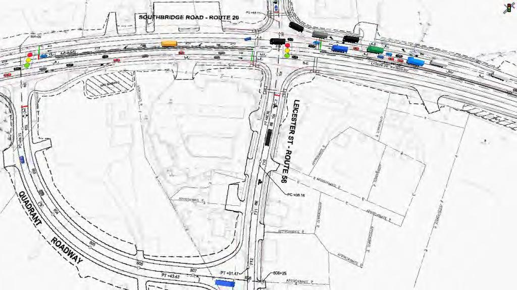
13 Route 56 Intersection
14 Route 56 Intersection
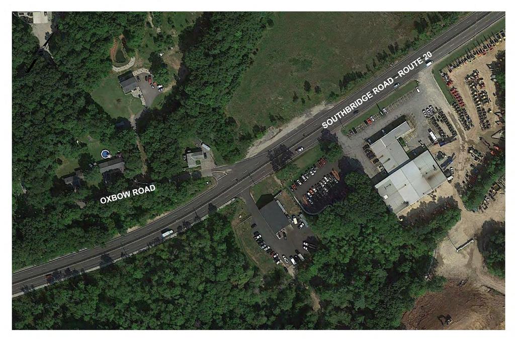
15 Oxbow Road Intersection

16 Oxbow Road Intersection

17 Richardson Corner Road Intersection
18 Richardson Corner Road Intersection
19 Project Update New Survey Baseplan July, 2016 Rte. 20 Roadway Safety Audit April, 2016 Subsurface Exploration Program January, 2016 thru January, 2017 Design Build Procurement Alternative Intersection Concepts at Rte. 56 FHWA Every Day Counts Innovation Improve Safety Improve Operations

20 Route 56 Intersection Advantages Less ROW and Frontage Impacts along Rte. 20 and Rte. 56 Improved Safety less conflict points = less accidents Improved Operations intersection capacity and travel time
21 OVERVIEW OF EXISTING LANE USAGE
22 OVERVIEW OF PROPOSED LANE USAGE
23 MODIFIED ROUTE 20 EASTBOUND LEFT TURN ROUTE
24 MODIFIED ROUTE 20 WESTBOUND LEFT TURN ROUTE
25 MODIFIED ROUTE 56 NORTHBOUND LEFT TURN ROUTE

26 MODIFIED ROUTE 56 SOUTHBOUND LEFT TURN ROUTE
27 MODIFIED ROUTE 56 EASTBOUND U- TURN ROUTE
28 MODIFIED ROUTE 56 WESTBOUND U- TURN ROUTE
29 FUTURE YEAR WITHOUT IMPROVEMENTS AVERAGE DELAYS WEEKDAY MORNING PEAK HOUR 0-20 sec >20-35 sec >35-55 sec >55-80 sec >80 sec

30 FUTURE YEAR WITHOUT IMPROVEMENTS AVERAGE DELAYS WEEKDAY AFTERNOON PEAK HOUR 0-20 sec >20-35 sec >35-55 sec >55-80 sec >80 sec
31 BUILD ALTERNATIVE AVERAGE DELAYS WEEKDAY MORNING PEAK HOUR 0-20 sec >20-35 sec >35-55 sec >55-80 sec >80 sec
32 BUILD ALTERNATIVE AVERAGE DELAYS WEEKDAY AFTERNOON PEAK HOUR 0-20 sec >20-35 sec >35-55 sec >55-80 sec >80 sec
33 Route 56 Intersection Travel Times Estimated travel times for through movements on Route 20 and Route 56 are less than or same as conventional intersection design o Fewer signal phases provides more green time to each signal phase Travel times for some left-turn / u-turn movements increase, due to longer path to complete the movement
34
35 Regulatory Approvals/Permits NEPA Class of Action (March, 2017) Individual Categorical Exclusion (August, 2017) MEPA - Draft Environmental Impact Report (June, 2017) Final Environmental Impact Report (December, 2017) ACOE Section 404 Individual (July, 2018) MassDEP Section 401 Water Quality Certificate (July, 2018) NHESP Conservation Management Permit (April, 2018) Conservation Commissions Notice of Intent/Order of Conditions (April, 2018)


36 Next Steps Anticipated Project Milestones o Massachusetts Environmental Policy Act DEIR Spring 2017 o Design Public Hearing Fall 2017 o Advertisement Date 2019
37 Public Comments, Q&A Feedback Oxford Charlton Reconstruction of Route 20 Project File Number Comments due by February 13, 2017
Exit 61 I-90 Interchange Modification Justification Study
 Exit 61 I-90 Interchange Modification Justification Study Introduction Exit 61 is a diamond interchange providing the connection between Elk Vale Road and I-90. Figure 1 shows the location of Exit 61.
PUBLIC HEARING LOOP 375 FRONTAGE ROADS RECONFIGURATION FROM FM 76 (NORTH LOOP DRIVE) TO ZARAGOZA PORT OF ENTRY CSJ: EL PASO COUNTY, TEXAS
 TO ZARAGOZA PORT OF ENTRY CSJ: EL PASO COUNTY, TEXAS") PUBLIC HEARING LOOP 375 FRONTAGE ROADS RECONFIGURATION FROM FM 76 (NORTH LOOP DRIVE) TO ZARAGOZA PORT OF ENTRY CSJ: 2552-03-058 EL PASO COUNTY, TEXAS Del Valle High School July 25, 2018 Hearing Information
PUBLIC HEARING LOOP 375 FRONTAGE ROADS RECONFIGURATION FROM FM 76 (NORTH LOOP DRIVE) TO ZARAGOZA PORT OF ENTRY CSJ: 2552-03-058 EL PASO COUNTY, TEXAS Del Valle High School July 25, 2018 Hearing Information
FARM TO MARKET 1103 OPEN HOUSE PUBLIC MEETING. FM 1103 I-35 to Rodeo Dr
 FARM TO MARKET 1103 OPEN HOUSE PUBLIC MEETING March 29, 2016 FM 1103 FROM: I-35 TO: RODEO DR COMAL & GUADALUPE COUNTY OPEN HOUSE PUBLIC MEETING March 29, 2016 5:00 p.m. 7:00 p.m. Barbara C Jordan Intermediate
DESIGN PUBLIC HEARING
 DESIGN PUBLIC HEARING JUNE 22, 2016 AT TOWN HALL AUDITORIUM 11 TOWN HOUSE ROAD WESTON, MASSACHUSETTS 7:00 PM FOR THE PROPOSED DEMOLITION OF LEGACY TOLL PLAZAS ALONG I-90 DISTRICT 6 PLAZAS 14, 15 AND 55
State Road A1A North Bridge over ICWW Bridge
 Final Report State Road A1A North Bridge over ICWW Bridge Draft Design Traffic Technical Memorandum Contract Number: C-9H13 TWO 5 - Financial Project ID 249911-2-22-01 March 2016 Prepared for: Florida
King Mill Lambert DRI# 2035 Henry County, Georgia
 Transportation Analysis King Mill Lambert DRI# 2035 Henry County, Georgia Prepared for: The Alter Group, Ltd. Prepared by: Kimley-Horn and Associates, Inc. Norcross, GA Kimley-Horn and Associates, Inc.
CHAPTER 1: TITLE SHEET and GENERAL LAYOUT
 CHAPTER 1: TITLE SHEET and GENERAL LAYOUT AREA OF ENVIRONMENTAL SENSITIVITY It is important to show the areas of environmental sensitivity in the plan to make sure these areas are not impacted. These locations
Complete Streets & PPM to FDM Update
 Florida Department of TRANSPORTATION Complete Streets & PPM to FDM Update Derwood Sheppard, P.E. Design Standards Paul Hiers, P.E. Roadway Criteria State Roadway Design Office February 2017 - FTBA Construction
Traffic and Roadway Improvements - Rte 123 (Belmont Street) Brockton, MA Client: BETA Group, Inc.
 Brockton, MA Client: BETA Group, Inc.") HIGHWAY PROJECT EXPERIENCE Traffic and Roadway Improvements - Rte 123 (Belmont Street) Brockton, MA Client: BETA Group, Inc. Alpha provided survey services to prepare a base plan of an approximately 2900
HIGHWAY PROJECT EXPERIENCE Traffic and Roadway Improvements - Rte 123 (Belmont Street) Brockton, MA Client: BETA Group, Inc. Alpha provided survey services to prepare a base plan of an approximately 2900
Maintenance of Traffic sequence of operations including any phasing and detour maps;
 All Local-let projects are required to have a Stage 2 submittal to the LPA Manager for review. The only exceptions are 2-lane resurfacing, striping, guardrail, and raised pavement markers, unless otherwise
CHAPTER 2C - PRELIMINARY DESIGN. General... 2C-1. Review of Work Load... 2C-2 Establishing Priorities... 2C-2
 SECTION 2C - 1 - PROJECT REVIEW CHAPTER 2C - PRELIMINARY DESIGN General... 2C-1 SECTION 2C - 2 - COORDINATING TIME SCHEDULES Review of Work Load... 2C-2 Establishing Priorities... 2C-2 SECTION 2C 3 - REVIEW
TYPICAL SECTION OF IMPROVEMENT
 ...\plans\0_prelim\07c_sh0.dgn /8/009 DIV. STATE COUNTY FILE OJECT TYPICAL CTION OF IMOVEMENT SC 7.0658A8 I-7 NORTHBOUND I7 SOUTHBOUND I7 8 8 0 8 VARIABLE (E CROSS CTIONS) : CONST..5.5 CONST. (
This page is intentionally left blank
 This page is intentionally left blank This page is intentionally left blank MnDOT Metro District Fact Sheet Mpls./St. Paul District Offices: Roseville-Water's Edge (HQ), Golden Valley, Oakdale mndot.gov/metro/
The Shoppes at Forney Crossings
 F M 548 U.S. HWY 80 U.S. HWY 80 F M 688 F M 548 COOL SPRINGS F M 1641 F M 548 TROPHY BUGLE CALL PHESANT WHITE PORCH SPINAKER The Shoppes at Forney Crossings 18' 14'-8" 18' 15'-8 1 2 " 14' 7' 23'-0" 21'-0"
TYPICAL SECTION OF IMPROVEMENT
 TYPICAL CTION OF IMOVEMENT STATE COUNTY FILE OJECT ROUTE DIV. SC MARION 7.0658A I-7 NORTHBOUND I7 SOUTHBOUND I7 WHERE CLEARZONE IS UNATTAINABLE OR END TREATMENT IS REQUIRED FOR 8 8 BRIDGE APOACH, ADD.5
50.24 Type, Size and Location Plans for Culverts, Bridges and Culvert Bridges
 50.24 Culverts, Bridges and Culvert Bridges Type, Size and Location (T, S & L) Plans shall be required for all Bridges, Culvert Bridges and Culverts of eight-foot (8') clear span or greater as follows:
Agenda Item No. August 28, Honorable Mayor and City Council Attention: David Van Kirk, City Manager. Dale I. Pfeiffer, Director of Public Works
 Agenda Item No. August 28, 2007 TO: FROM: SUBJECT: Honorable Mayor and City Council Attention: David Van Kirk, City Manager Dale I. Pfeiffer, Director of Public Works RESOLUTION TO ADOPT A MITIGATED NEGATIVE
STANDARD DRAWINGS INDEX MODIFIED FOR CENTRAL REGION Revised August 6, 2018
 SYMBOLS STANDARD DRAWINGS INDEX No Statewide Standard - Use Regional A3 Legend Detail Sheet BRIDGE AND STRUCTURES B-08.00 Bin Walls 1 CONSTRUCTION-BARRICADES AND SIGNING C-04.12 Location of Double Traffic
Guide Sign Policy for Secondary State Highways Edition
 Massachusetts Highway Department, Ten Park Plaza, Boston, MA 02116-3973 ` Guide Sign Policy for Secondary State Highways 2005 Edition Revised September 2005 1. PURPOSE The Massachusetts Highway Department
SECTION 3 IMPROVEMENT PLAN REQUIREMENTS
 SECTION 3 IMPROVEMENT PLAN REQUIREMENTS CONTENTS Page 3-1 Digital Submittals 3-2 3-2 Paper Size and Scale 3-2 3-3 Drafting Standard 3-2 3-4 Title Sheet 3-2 3-5 Title Block 3-3 3-6 Drainage, Sewer, Water,
DELINEATOR REFERENCE POINT 200' TYPICAL SPACING (YELLOW DELINEATORS) END OF MERGE LANE TAPER DELINEATOR REFERENCE POINT
 END OF MERGE LANE TAPER DELINEATOR REFERENCE POINT") 200' TYP. 600' < EACH SIDE BOTH ROADWAYS END OF MERGE LANE TAPER TYPICAL FOR ALL 2-LANE MERGES EXCEPT WHERE THERE IS A MERGE FROM THE RIGHT AND NO OFFSET IN THE THROUGH LANES END OF MERGE LANE TAPER 200'
200' TYP. 600' < EACH SIDE BOTH ROADWAYS END OF MERGE LANE TAPER TYPICAL FOR ALL 2-LANE MERGES EXCEPT WHERE THERE IS A MERGE FROM THE RIGHT AND NO OFFSET IN THE THROUGH LANES END OF MERGE LANE TAPER 200'
Demolition of Ramp C (SN ): Westbound Ontario Street to Eastbound I-90/94) over I-90/94 (JF Kennedy Expressway)
: Westbound Ontario Street to Eastbound I-90/94) over I-90/94 (JF Kennedy Expressway)") I-90/94 (Kennedy Expressway) at Ohio Street Structure Replacement and Rehabilitation Section Number 0303-474HB-R D-91-177-09 Contract 60F63 Cook County, Region One, District One City of Chicago Project
I-90/94 (Kennedy Expressway) at Ohio Street Structure Replacement and Rehabilitation Section Number 0303-474HB-R D-91-177-09 Contract 60F63 Cook County, Region One, District One City of Chicago Project
REQUEST FOR PROPOSAL
 REQUEST FOR PROPOSAL Engineering Design Services for the Preliminary Engineering of Lake Nepessing/Davison/Genesee Intersection Improvements Sections 1, 2, 11 and 12 of Elba Township Lapeer County, Michigan
Plan Preparation Checklist
 Appendix D Plan Preparation Checklist It is the responsibility of the Designer to complete and submit this checklist along with all required drawings for OUC (EFP) Review. All drawings submitted for OUC
The Missouri Department of Transportation is proposing to amend the state's five-year Statewide Transportation Improvement Program (STIP).
.") The Missouri Department of Transportation is proposing to amend the state's five-year Statewide Transportation Improvement Program (STIP). A 7-day public comment period regarding the amendment begins February
The Missouri Department of Transportation is proposing to amend the state's five-year Statewide Transportation Improvement Program (STIP). A 7-day public comment period regarding the amendment begins February
Pacificans for Highway 1 Alternatives c/o Hal Bohner
 Pacificans for Highway 1 Alternatives c/o Hal Bohner 1 1 5 A n g e l i t a A v e n u e P a c i f i c a, C A 9 4 0 4 4 phone 650-359-4257 hbohner@earthlink.net Via Email September 6, 2012 Mr. Bijan Sartipi
TRAFFIC IMPACT STUDY. PROPOSED AMENDED MASTER PLAN AMENDED - H - ZONE Village of Ridgewood Bergen County, New Jersey
 TRAFFIC IMPACT STUDY PROPOSED AMENDED MASTER PLAN AMENDED - H - ZONE Village of Ridgewood Bergen County, New Jersey Prepared For: The Valley Hospital 223 North Van Dien Avenue Ridgewood, New Jersey 07450
EVALUATING AN ADAPTIVE SIGNAL CONTROL SYSTEM IN GRESHAM. James M. Peters, P.E., P.T.O.E., Jay McCoy, P.E., Robert Bertini, Ph.D., P.E.
 EVALUATING AN ADAPTIVE SIGNAL CONTROL SYSTEM IN GRESHAM James M. Peters, P.E., P.T.O.E., Jay McCoy, P.E., Robert Bertini, Ph.D., P.E. ABSTRACT Cities and Counties are faced with increasing traffic congestion
WELCOME. Open House. meeting is downstairs in the Foot Room RED WING BRIDGE PROJECT. US 63 River Bridge and Approach Roadways.
 WELCOME RED WING BRIDGE PROJECT US 63 River Bridge and Approach Roadways Open House meeting is downstairs in the Foot Room November 2016 Plum/3rd Street Traffic Control Change Signal to All-Way Stop Plum
Appendix D. Traffic Noise Analysis Report. I-94 St. Michael to Albertville Minnesota Department of Transportation
 Appendix D Traffic Noise Analysis Report I-94 St. Michael to Albertville Minnesota Department of Transportation Traffic Noise Analysis Report I-94 St. Michael to Albertville Project SP 8680-172 Report
Appendix G. Visual Simulations and Illustrations
 Appendix G Visual Simulations and Illustrations 5TH AVE AV E N View ewshe ed 5 SHORELINE N 185TH ST egment B gment A 26 NE 185th Street Station (A1, A3, A5, A7, A10, A11) 25 24 23 22 21 NE 180TH ST 99
Memorandum 1.0 Highway Traffic Noise
 Memorandum Date: September 18, 2009 To: Chris Hiniker, SEH From: Stephen B. Platisha, P.E. Re: Updated CSAH 14 Noise Analysis The purpose of this memorandum is to provide the results of the revised traffic
GCG ASSOCIATES, INC. February 8, Mr. Nathaniel Strosberg, Town Planner 101 Main Street Town of Ashland Ashland, MA 01721
 GCG ASSOCIATES, INC. CIVIL ENGINEERING AND LAND SURVEYING 84 Main Street Wilmington, Massachusetts 01887 Phone: (978) 657-9714 Fax: (978) 657-7915 February 8, 2016 Mr. Nathaniel Strosberg, Town Planner
DIVISION PAVEMENT MARKINGS AND MARKERS
 DIVISION 61 66 PAVEMENT MARKINGS AND MARKERS 66.01 SCOPE: The purpose of these specifications is to describe the minimum requirements of the City of Chesapeake for pavement markings and shall be in addition
Update on Traffic Results and Findings
 Los Angeles County Metropolitan Transportation Authority Update on Traffic Results and Findings presented to the Corridor Advisory Committee February 16, 2017 Traffic Presentation Topics 2 Traffic Volumes
Welcome Public Open House
 Peachland Study Welcome Public Open House Preliminary Review of Alternate & Existing Route Options Peachland Study Open House Purpose & Objectives 1. Present possible options for meeting the current and
Interchange Feasibility Study
 Interchange Feasibility Study I-88/Illinois Route 47 Full Interchange Kane County, IL Prepared for Village of Sugar Grove, Illinois August 5, 2010 Prepared by GRAEF 8501 West Higgins Road, Suite 280 Chicago,
Summerland Planning Advisory Committee. SunPAC Meeting #31 April 28, 2011
 Summerland Planning Advisory Committee SunPAC Meeting #31 April 28, 2011 1 SunPAC Meeting Agenda Call to Order Item 1: Pledge of allegiance and roll call Agenda Item: 1 Item 2: Public comment period Item
SITE PLAN APPLICATION
 SITE PLAN APPLICATION SECTION 1. APPLICANT/OWNER INFORMATION Please Print or Type Applicant/Developer: City: State: Zip: Telephone: Fax: E-mail: Applicant s Status: (Check One) Owner Tenant Prospective
Zoning District: R-1, R-2, and R-4 Applicant: Exeter Rose Farm, LLC, 953 Islington Street #23D Portsmouth, NH 03801
 2220.00, Town Planner Town Planning Office, Town of Exeter 10 Front Street Exeter, NH 03833 Re: Exeter Rose Farm Subdivision Design Review Engineering Services Exeter, New Hampshire Site Information: Tax
REPORT TO COUNCIL DORWICK DITCH PETITION REHABILITATION PROJECT JUNE 8, 2016
 REPORT TO COUNCIL DORWICK DITCH PETITION REHABILITATION PROJECT JUNE 8, 2016 Based on a preliminary study by Euthenics, Inc. www.euthenics_inc.com 1 SECTION I GENERAL INFORMATION AND EXISTING CONDITIONS
Planarization & Routing Guide
 Metro Regional Centerlines Collaborative Planarization & Routing Guide Document: Version. Published: July 8, 25 Prepared and edited by: Matt Koukol, MRCC Project Technical Lead Ramsey County GIS Manager
Purple Line Extension Section 3 Pre-Construction Community Meeting March 22, 2018
 Purple Line Extension Section 3 Pre-Construction Community Meeting March 22, 2018 1 Agenda Westwood/UCLA Map and Schedule Advance Utility Relocation Bus Stop Relocations Westwood/VA Hospital Map Advance
FM 691 CORRIDOR STUDY
 FM 691 CORRIDOR STUDY Transportation Policy Board Meeting August 13, 2008 Agenda Project Overview US 75/FM 691 Interchange US 75 Ramping Alternatives FM 691 Corridor Typical Sections Extension to SH 289
Study Description. November 29, Overpass Road Alternatives Public Workshop
 Overpass Road Alternatives Public Workshop November 29, 2012 Welcome to the Alternatives Public Workshop for proposed improvements to Overpass Road in Pasco County. Pasco County (the County), in coordination
Expressway Authority Standards for Preparation of Signing and Pavement Marking Plans
 Expressway Authority Standards for Preparation of Signing and Pavement Marking Plans Expressway Authority Standards for Preparation of Signing and Pavement Marking Plans 408 414 417 429 451 528 CENTRAL
CHAPTER 14: TRAFFIC SIGNAL STANDARDS Introduction and Goals Administration Standards Standard Attachments 14.
 14.00 Introduction and Goals 14.01 Administration 14.02 Standards 14.03 Standard Attachments 14.1 14.00 INTRODUCTION AND GOALS The purpose of this chapter is to outline the City s review process for traffic
FINAL REPORT. On Project Supplemental Guidance on the Application of FHWA s Traffic Noise Model (TNM)
") FINAL REPORT On Project 25-34 Supplemental Guidance on the Application of FHWA s Traffic Noise Model (TNM) APPENDIX A Structure Reflected Noise and Expansion Joint Noise Prepared for: National Cooperative
FINAL REPORT On Project 25-34 Supplemental Guidance on the Application of FHWA s Traffic Noise Model (TNM) APPENDIX A Structure Reflected Noise and Expansion Joint Noise Prepared for: National Cooperative
Chapter 23. Signing and Pavement Marking Plans
 Chapter 23 Signing and Pavement Marking Plans 23.1 General... 23-3 23.2 Key Sheet... 23-4 23.3 Signature Sheet... 23-4 23.4 Tabulation of Quantities and Pay Item Notes... 23-4 23.4.1 Standard Notes...
Attachment #2 PPW133-07
 Attachment #2 PPW133-07 Pg. 1 EXECUTIVE SUMMARY Environmental Assessment Study In January 2005, Regional staff retained to commence a Schedule C Environmental Assessment Study to identify the improvements
Florida's Turnpike Enterprise Roadway Phase III (90%) & Phase IV (100%) Check List Per FDM and TDH Part 3
 & Phase IV (100%) Check List Per FDM and TDH Part 3") Notes to Reviewers Section 301 Design Exceptions, Variation, and Technical Memorandums Special directives date and source Key Sheet Section 302 Location Map w/ location of project on map All applicable
Notes to Reviewers Section 301 Design Exceptions, Variation, and Technical Memorandums Special directives date and source Key Sheet Section 302 Location Map w/ location of project on map All applicable
2.8 NOISE. Chapter IX 2. Comments and Responses CONSTRUCTION NOISE. Comment
 2.8 NOISE 2.8.1 CONSTRUCTION NOISE The noise impacts are not adequately addressed or studied in the DEIR, as there appears to be no analysis at all of potential noise level increases as measured from locations
BOSTON EVERETT HORIZON WAY BROADWAY ALFORD ST BOW ST BOSTON CITY LINE EVERETT CITY LINE DEXTER ST MYSTIC ST COURTLAND ST LYNDE ST THORNDIKE ST
 BOSTON HORIZON WAY ALFORD ST BROADWAY BOSTON CITY LINE CITY LINE MANHOLE #101 (STA 5+00) BOW ST DEXTER ST ST LYNDE ST THORNDIKE ST COURTLAND ST RIVER PROP (TYP) ROBIN ST BETTY ST 50 500 1. BASELINE STATIONING
Noise Mitigation Study Pilot Program Summary Report Contract No
 Ohio Turnpike Commission Noise Mitigation Study Pilot Program Summary Report Contract No. 71-08-02 Prepared For: Ohio Turnpike Commission 682 Prospect Street Berea, Ohio 44017 Prepared By: November 2009
ACEC OC February 22, 2017
 ACEC OC February 22, 2017 I-405 Freeway 1958 I-405 Freeway Today Measure R Highway Projects Study Area Highway Program Project Status Summary (Measure R Funded) # Project Current Phase Estimated Cost of
Purple Line Extension Section 3 Pre-Construction Community Meeting June 21, 2018
 Purple Line Extension Section 3 Pre-Construction Community Meeting June 21, 2018 1 Agenda Environmental Updates UCLA Station Advance Utility Relocation VA Station Advance Utility Relocation Underground
SUBJECT: Standard Plate 9102 Turf Establishment Areas At Pipe Culvert Ends
 MINNESOTA DEPARTMENT OF TRANSPORTATION DEVELOPED BY: Design Standards ISSUED BY: Office of Project Management and Technical Support, Design Support Section TRANSMITTAL LETTER NO. (17-03) MANUAL: Standard
Documents: Response letter and attachments, Prepared by: AMEC Massachusetts, Inc., Dated February 17, 2016.
 GCG ASSOCIATES, INC. CIVIL ENGINEERING AND LAND SURVEYING 84 Main Street Wilmington, Massachusetts 01887 Phone: (978) 657-9714 Fax: (978) 657-7915 February 23, 2016 Mr. Nathaniel Strosberg, Town Planner
Porter County Plan Commission
 Plan Type: Development Plan Administrative DRC PC Primary Plan Administrative DRC PC Secondary Plat/Replat Administrative DRC PC PUD Conceptual Detailed Final Project Information Project Name: Developer
X X X X X X. ! Proposed Signalized HIGHWAY 55 PEDESTRIAN CROSSINGS
 HIGHWY 55 PEDESTRIN CROSSINGS» This graphic depicts walking distances to proposed signalized intersections along Olson Highway if existing unsignalized crossings are closed. Farwell Mpls College Prep Charter
Update: July 20, 2012
 Location and Design Manual, Volume 3 ODOT Office of CADD and Mapping Services Update: July 20, 2012 ** NOTE: All metric references have been removed from this manual. ** PREFACE REVISIONS Glossary of Terms
TECHNICAL INFORMATION Traffic Template Catalog No. TT1
 Copyright 2016 by SIRCHIE All Rights Reserved. TECHNICAL INFORMATION Traffic Template Catalog No. TT1 INTRODUCTION Your SIRCHIE Traffic Template is a versatile police tool designed to make even the most
INSTRUCTIONS: 1. Record the transmittal letter number, date, and subject on the transmittal record sheet located in the front of the manual.
 MINNESOTA DEPARTMENT OF TRANSPORTATION DEVELOPED BY: Design Standards ISSUED BY: Office of Technical Support Design Services Section TRANSMITTAL LETTER NO. (0-03) MANUAL: Standard Plates DATED: September
Appendix CANADA / Québec Montréal tunnels Ville-Marie & Viger
 PIARC WG5 Complex Underground Road Networks Part A Case Studies - appendices Appendix 3.1 - CANADA / Québec Montréal tunnels Ville-Marie & Viger 1. SUMMARY The Ville-Marie and Viger tunnel complex is part
Circulation / Transportation. A. Background
 V Circulation / Transportation A. Background Halifax is in Southeastern Massachusetts, bordered by Bridgewater and East Bridgewater on the West, Middleboro on the South, Plympton on the East and Southeast,
MINUTES OF THE METROPOLITAN PLANNING ORGANIZATION MEETING HELD SEPTEMBER 24, 2014 AT 4 P.M. The Metropolitan Planning Organization met on
 MINUTES OF THE METROPOLITAN PLANNING ORGANIZATION MEETING HELD SEPTEMBER 24, 2014 AT 4 P.M. The Metropolitan Planning Organization met on September 24, 2014, at 4 p.m., in the Council Chambers of the Municipal
Locate Request Information
 Locate Request Information NOTE: DO NOT USE any apostrophes ( )or quotation marks ( ) in Web Ticket Entry. Doing so may hamper the transmission of tickets to the utilities and locators. Limit per Ticket
APPLICATION FOR SITE PREPARATION PERMIT
 Engineering Division 550 Landa Street New Braunfels, Texas 78130 (830) 221-4020 1. Subdivision/Plat Name: Location Description/ Nearest Intersection: Acreage: APPLICATION FOR SITE PREPARATION PERMIT No.
Updated: April 7, 2016
 Updated: April 7, 2016 Hwy 36 to Lexington Ave. Add a lane in each direction Recommend a MNPASS Lane Several spot improvements to roadway included Concrete pavement Noise walls will be evaluated Replace
DEVELOPMENT PLAN CHECKLIST
 Project Identification Information: DEVELOPMENT PLAN CHECKLIST 1.0 GENERAL 1.1 Additional information as required by specific Land Use 1.2 All sheets to include sheet number ( of ) 1.3 Seal and signature
CHECKLIST PRELIMINARY SUBDIVISION AND PRELIMINARY SITE PLAN
 N/A Waiver (1) Four (4) copies of application form. (2) Fifteen (15) copies of plan (3) Subdivision/site plan application fee & professional review escrow deposit (4) Variance application fee & professional
Currently 2 vacant engineer positions (1 Engineer level, 1 Managing Engineer level)
") INDOT Agency Factoids (System/Comm.) Number of signalized intersections- 2570 200 connected by fiber 300 connected by radio 0 connected by twisted pair 225 connected by cellular 1500 not connected to communication
INDOT Agency Factoids (System/Comm.) Number of signalized intersections- 2570 200 connected by fiber 300 connected by radio 0 connected by twisted pair 225 connected by cellular 1500 not connected to communication
Straight Line Diagram. Lawrence 37. January 2010
 Straight Line Diagram Lawrence 37 January 2010 This document was produced by the Pennsylvania Department of Transportation (PENNDOT) as an internal management tool for State maintained highways and is
Using Multimodal Performance Measures to Prioritize Improvements on US 101 in San Luis Obispo County
 Portland State University PDXScholar TREC Friday Seminar Series Transportation Research and Education Center (TREC) 4-24-2015 Using Multimodal Performance Measures to Prioritize Improvements on US 101
2. Remove from the Standard Plate manual: Standard Plate Index, Sheets 1-4 of 4, Numerical Index of Standard Plates (August 31, 2012)
") MINNESOTA DEPARTMENT OF TRANSPORTATION DEVELOPED BY: Design Standards ISSUED BY: Office of Program Management & Technical Support, Design Support Section TRANSMITTAL LETTER NO. (12-04) MANUAL: Standard
MINNESOTA DEPARTMENT OF TRANSPORTATION DEVELOPED BY: Design Standards ISSUED BY: Office of Program Management & Technical Support, Design Support Section TRANSMITTAL LETTER NO. (12-04) MANUAL: Standard
PUBLICATION 213. Think Safety First
 PUBLICATION 213 (67 PA CODE, CHAPTER 212) Think Safety First Pub 213 (02-08) Appendix Appendix A - Temporary/Portable
Current Standard Plates including Transmittal Letters are available on the web at:
 MINNESOTA DEPARTMENT OF TRANSPORTATION DEVELOPED BY: Design Standards ISSUED BY: Office of Project Management and Technical Support, Design Support Section TRANSMITTAL LETTER NO. (17-04) MANUAL: Standard
DE 8 Concept Plan and Operations Study. City of Dover Safety Advisory and Transportation Committee Meeting December 1, 2008
 DE 8 Concept Plan and Operations Study City of Dover Safety Advisory and Transportation Committee Meeting December 1, 2008 Purpose Develop a concept plan describing the aesthetic qualities of the corridor
I-20 East Texas Corridor Implementation Plan DALLAS DISTRICT Updated May Install cable barrier system in median
 I-20 East Texas Corridor Implementation Plan DALLAS DISTRICT Updated May 2016 AE-1 Median Barrier I-635 to Kaufman County Line AF-1 Lawson Road to Kaufman County Line Install cable barrier system in median
PENSACOLA BAY BRIDGE PROJECT DEVELOPMENT AND ENVIRONMENT (PD&E) STUDY. Noise Study Report. SR 30 (US 98) From 17th Avenue To Baybridge Drive
 STUDY. Noise Study Report. SR 30 (US 98) From 17th Avenue To Baybridge Drive") PENSACOLA BAY BRIDGE PROJECT DEVELOPMENT AND ENVIRONMENT (PD&E) STUDY SR 30 (US 98) From 17th Avenue To Baybridge Drive Escambia and Santa Rosa Counties, Florida Financial Project ID No. 409334-1 Federal
PENSACOLA BAY BRIDGE PROJECT DEVELOPMENT AND ENVIRONMENT (PD&E) STUDY SR 30 (US 98) From 17th Avenue To Baybridge Drive Escambia and Santa Rosa Counties, Florida Financial Project ID No. 409334-1 Federal
GEORGE MASSEY TUNNEL REPLACEMENT PROJECT PHASE 2 EXPLORING THE OPTIONS CONSULTATION SUMMARY REPORT AUGUST 2013
 GEORGE MASSEY TUNNEL REPLACEMENT PROJECT PHASE 2 EXPLORING THE OPTIONS CONSULTATION SUMMARY REPORT AUGUST 2013 This independent report of findings, including data entry and analysis of all the consultation
VAN AKEN DISTRICT CONNECTIONS PLAN
 VAN AKEN DISTRICT CONNECTIONS PLAN COMMUNITY MEETING #2 SEPTEMBER 29, 2016 7:00 7:30 7:30 8:15 8:15 9:00 Open House Presentation Open House http://shakeronline.com/departments/planning/van-aken/a-connections-plan-for-the-van-aken-district
WILTON MANORS, Island City 2020 WILTON DRIVE, WILTON MANORS, FLORIDA 33305
 WILTON MANORS, Island City 2020 WILTON DRIVE, WILTON MANORS, FLORIDA 33305 COMMUNITY DEVELOPMENT SERVICES (954) 390-2180 FAX: (954) 567-6069 This package includes: General Submittal Procedures Submittal
# Insite RE Inc./ Verizon Wireless Special Use Permit Project Review for Planning and Zoning Commission
 #2015-52 Insite RE Inc./ Verizon Wireless Special Use Permit Project Review for Planning and Zoning Commission Meeting Date: October 21, 2015 Request: Location: A Special Use Permit for a wireless communication
INNOVATIVE DEPLOYMENT OF DYNAMIC MESSAGE SIGNS IN SAFETY APPLICATIONS
 INNOVATIVE DEPLOYMENT OF DYNAMIC MESSAGE SIGNS IN SAFETY APPLICATIONS L.A. Griffin Director of Expressway Operations, Orlando-Orange County Expressway Authority 4974 ORL Tower Road Orlando, FL 32807 (407)
CONCURRENT OPTIMIZATION OF SIGNAL PROGRESSION AND CROSSOVER SPACING FOR DIVERGING DIAMOND INTERCHANGES
 CONCURRENT OPTIMIZATION OF SIGNAL PROGRESSION AND CROSSOVER SPACING FOR DIVERGING DIAMOND INTERCHANGES Yao Cheng*, Saed Rahwanji, Gang-Len Chang MDOT State Highway Administration University of Maryland,
APC REGULATORY UPDATE NOVEMBER 16, PennDOT AND
 APC REGULATORY UPDATE PennDOT AND NOVEMBER 16, 2017 WELCOME TO THE APC Regulatory Overview Threatened and Endangered Bats & Bridges PA DEP Functional Assessments & NPDES Waters of the United States Mitigation
Exhibit A SCOPE OF WORK AND DELIVERABLES T.H. 169 Mountain Iron to Hoover Road in Virginia
 Exhibit A SCOPE OF WORK AND DELIVERABLES T.H. 169 Mountain Iron to Hoover Road in Virginia PROJECT OVERVIEW S.P. 6935-89 is on T.H. 169 from 0.07 miles west of CR 109 in Mt. Iron to Hoover Road in Virginia
Frequently Asked Questions
 The Synchro Studio support site is available for users to submit questions regarding any of our software products. Our goal is to respond to questions (Monday - Friday) within a 24-hour period. Most questions
I-405 Sepulveda Pass Improvements Project. Quarterly Community Meeting December 9, 2010
 I-405 Sepulveda Pass Improvements Project Quarterly Community Meeting December 9, 2010 1 Project Boundaries Southern boundary from National Bl. south to the Santa Monica-Rosa Parks Freeway (I-10) Northern
BOARD OF DIRECTORS MEETING MINUTES
 Board Voting Members Present: BOARD OF DIRECTORS MEETING MINUTES Osage Centre Cape Girardeau, MO Mr. Drew Christian, Southeast Missouri Regional Planning & Economic Development Commission (SEMO RPC) (alternate
Jointing Rural Intersections
 Design Manual Chapter 5 - Roadway Design 5G - PCC Pavement Joints 5G-4 Jointing Rural Intersections This section describes how to joint rural intersections by following the guidelines outlined in Iowa
June 5, The following persons signed in as being present in the audience:
 June 5, 2017 The East Lampeter Township Board of Supervisors met on Monday, June 5, 2017, at 7:30 pm. at the East Lampeter Township Office: 2250 Old Philadelphia Pike, Lancaster, PA 17602. The meeting
Article 4.0 Measurements and Exceptions
 This Article identifies and explains some of the more common forms of measurement used throughout this Ordinance. It also specifies exceptions to certain requirements of this Ordinance. Sec. 4.1 Measurements
Appendix B: Noise Study
 Appendix B: Noise Study creating remarkable solutions for a higher quality of life NOISE STUDY Interstate 55 Route PP to County Road 311 Prepared for: MoDOT PROJECT NO. J010956 November 2014 Prepared
A. INTRODUCTION PRINCIPAL CONCLUSIONS
 Chapter 16: Traffic and Parking A. INTRODUCTION This chapter examines the potential traffic and parking impacts of the proposed development of the Fresh Kills Park project. The analysis of the proposed
Instructors Manual for Construction Surveying and Layout Third Edition Part Three - Applications Chapters Prepared by Wesley G.
 Instructors Manual for Construction Surveying and Layout Third Edition Part Three - Applications Chapters 19-22 Prepared by Wesley G. Crawford TABLE OF CONTENTS Chapter 19 - Layout Techniques... 3 Chapter
I-405 Sepulveda Pass Improvements Project. Community Advisory Committee September 23, 2010
 I-405 Sepulveda Pass Improvements Project Community Advisory Committee September 23, 2010 1 Click to edit Master title style Click to edit Master text styles Regional Project Updates Second level Third
TURNPIKE DESIGN HANDBOOK (TDH) DESIGN CRITERIA PART 2
 DESIGN CRITERIA PART 2") TURNPIKE DESIGN HANDBOOK (TDH) DESIGN CRITERIA PART 2 FLORIDA S TURNPIKE ENTERPRISE PRODUCTION DESIGN DEPARTMENT OCOEE, FL January 2018 May 2, 2018 Addendum #1 Introduction As part of the Turnpike s continuing
TURNPIKE DESIGN HANDBOOK (TDH) DESIGN CRITERIA PART 2 FLORIDA S TURNPIKE ENTERPRISE PRODUCTION DESIGN DEPARTMENT OCOEE, FL January 2018 May 2, 2018 Addendum #1 Introduction As part of the Turnpike s continuing
Appendix E-4. City of Fort Collins. Requirements for Utility Plans
 Appendix E-4 City of Fort Collins Requirements for Utility Plans Project Name: Project Planner: Design Engineering Firm: Developer: All applications for final development plans must include final development