Accident at Sellafield - consequences for Norwegian food production
|
|
|
- Lily Ray
- 6 years ago
- Views:
Transcription


1 Accident at Sellafield - consequences for Norwegian food production Losby Gods,
2 Sellafield source of radioactivity Accident scenario at sellafield Simulated deposition in Norway Part II The Stratos model Stratos used on the Sellafield scenario Affected foodstuff
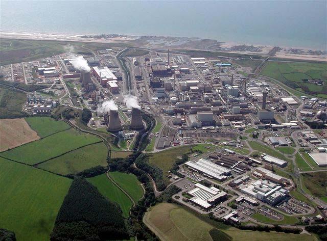
3 Sellafield
4 Scenario details The chosen worst case scenario is an explosion in B215 facility at Sellafield which contains Highly Active Liquor (HAL) stored in Highly Active Storage Tanks (HASTs). The explosion is assumed to be due to a malicious act targeting the facility. The direct cause of the explosion is not speculated upon though it is recognised that such an event will be of low probability. The explosion and heat generated from a subsequent fire are such that a percentage of the assumed HAL radionuclide inventory is released into the atmosphere.
5 The source term The scenario considers a source term of between ~0.1 % and 10 % of the total HAL volume. The source term is therefore defined as a release of 1 to 100 m 3 of HAL. For simplification, only 137 Cs considered in this scenario. A real release of HAL would contain many different radionuclides.
6 The source term Source term used in the scenario compared to the assumed releases from the Chernobyl accident. Radionuclide source termreleases from Chernobyl (UNSCEAR PBq PBq 137 Cs (1 PBq = Bq)
7 The dispersion model used The original model was developed at the Norwegian Meteorological Institute, based on the UK Meteorological Office model NAME via collaboration between the two partners. Three basic processes are taken into account: emission from a point-source transport/dispersion deposition of radioactivity. Releases of 137 Cs are assumed to be in an aerosol form.
8 Weather during scenario The weather situation was dominated by southwest winds from the UK blowing across the North Sea towards Scandinavia leading to extensive precipitation on Norway s western coast. This weather type is considered typical in the studied area. Weather data corresponds to the weather situation that occurred starting 22 October 2008 at 09:00 am. The observed weather October, 2008
9 Fallout patterns over time 9 hours Accumulated total deposition for 2.2 μm particle radius 48 hours

10 Fallout animation
11 Fallout pattern after 48 hours 1 % HAL released 10 % HAL released

12 Comparison with Chernobyl fallout in Norway The Chernobyl accident fallout The 1 % accident scenario fallout
13 Part II A model for rough grazing Need for a model that could estimate the consequences for the Norwegian rough grazing animals. We are now developing the Stratos model We would like Stratos to: Be a model for the Norwegian foodstuff in alpine and forest areas Be a tool for consequence analysis and a tool for stakeholders in case of a sever nuclear accident Be simple, flexible and alive Be database and GIS based Contain a substantial amount of relevant geographical data for Norway Be developed and maintained locally with close cooperation between the developers and the scientists and users
14 Stratos Tag based We have limited information on rough grazing animals diet What do they prefer How much do they eat How does it change with season How are the geographical differences Thus, we choose to use Tag values, or more precise: Tag ranges Tag = We define three Tag values from the Tag distribution: expected Tag: the mean high Tag: the 95 % percentile low Tag: the 5 % percentile Together with these Tag values we apply the intervention levels for foodstuff in Norway.

15 Stratos Tag based Tag values changes in time and space.

16 Stratos - tags Areas above the intervention limit for elk in Norway. The different colours reflect the different Tag values. Note that the red areas are "on top of" the yellow areas which again is "on top of" the green areas. This is a logical consequence of the definition of the areas. The figure does not say how high levels we might expect, only if the levels are above the intervention level for a given Tag
17 Stratos -tags For deer we get the same figure as for elk Red: high probability for exceeding the intervention level Orange: Areas expected to exceed the intervention level Kaki: Some areas here might exceed the intervention level; Areas with high transfer.
18 Stratos affected foodstuff The previous maps don t say how many deer or elk that are affected Thus, we apply geographical information Elk Deer Number of animals slaughtered during hunting season

19 Affected foodstuff
20 Affected foodstuff If we also have information about the location of the animals
21 Stratos Currently this method can be applied for: Elk, deer, sheep and reindeer Easily expand for other animal just input Tag values and geographical information. Other animals that are of interest for Norway are: Gout, rough grazing cows, Can also be used to look at products from animals.
22 Sellafield - Stratos Thank you!
23 Stratos - Tags Since the Chernobyl accident there has been done a lot of monitoring in the Norwegian foodstuff Stratos aims to use these data determine the sensitivity of the different areas For now, we use the data to derive some tag dispersions To derive these Tag values, a interpolated 5km * 5km raster map from about 430 soil samples from across Norway was made, a sort of artificial deposition map The gis function "v.rast.stats" is used on this interpolated map and a foodstuff region map, producing a new map containing the mean deposition values in each foodstuff region together with the monitoring values which we previously have added toour food stu region map.
24 Stratos - tags A simple database operation of and a column with Tag values for all regions was made.
25 Stratos tags Thoughts for the future: Collect more of the monitoring data. Challenging They might not be digital Personal calls Names have changed Calculate tags for more years and look at time development Connect tags to environmental parameters in order to generalize tags for different environments. Same environments have the same tag values.
26 Concluding remarks The meteorological model used is of a high quality, however: Chosen weather conditions will affect fallout results. All assumptions about the source term will also affect the predicted fallout. During typical weather conditions, an accidental atmospheric release from Sellafield could have consequences for Norway in the form of radioactive fallout after a time span of as little as nine hours. This is important with regard to emergency planning. The relevant authorities in Norway would therefore like to receive more information regarding UK accident scenarios & prompt notification of incidents at Sellafield.
27 Stratos The uptake of radionuclides in the food web varies from species to species and there can also be significant differences in the uptake at different location Monitoring reveals that we have geographical differences in uptake across Norway. Accounting for geographical differences by adding lots off different environmental parameters Seems hopeless. Stratos uses, as other models, Tags for the Becquerel level estimates But instead of on Tag value, Stratos looks at tag range
28 Stratos -tags For some Tag values the method described has been used, but for now, with focus on the dispersion of the tags. For other Tag values we will refer to values derived in articles Applying the tag values to Stratos In contrast to other models, Stratos don't look at one Tag value, but rather at the Tag value range. We define three Tag values from the Tag distribution, expected Tag, high Tag and low Tag, which reflect the mean, the 95 % percentile and the 5 % percentile respectively Together with these Tag values we apply the intervention limits for foodstuff in Norway. This gives us the opportunity to display which areas will have foodstuff which pas the intervention limit at different Tag values
29 Stratos - tags With this method we can derive regional Tag values for Norway and we can look at the dispersion of Tag values in Norway. But... we do not have monitoring data for all of Norway the data we have is not uniformly dispersed but grouped at locations that were most affected by the Chernobyl accident. So applying Tag values from these parts of Norway to other parts, may not be a good assumption.
30 Stratos Tag based We have little information on rough grazing animals diet What do they prefer How much do they eat How does it change with season Thus, we choose to use Tag values, or more precise: Tag ranges Tag = We define three Tag values from the Tag distribution: expected Tag: the mean high Tag: the 95 % percentile low Tag: the 5 % percentile Together with these Tag values we apply the intervention limits for foodstuff in Norway.
RADIOACTIVE CONTAMINATION OF NEST MATERIAL DUE TO THE FUKUSHIMA NUCLEAR ACCIDENT IN PASSERINE BIRDS
 RADIOACTIVE CONTAMINATION OF NEST MATERIAL DUE TO THE FUKUSHIMA NUCLEAR ACCIDENT IN PASSERINE BIRDS Matsui S 1, Kasahara S 1, Morimoto G 1, Mikami OK 2, Watanabe M 3, Ueda K 1 1 Rikkyo Uni, 2 Iwate- Medical
ADDAM (Atmospheric Dispersion and Dose Analysis Method)
") ADDAM (Atmospheric Dispersion and Dose Analysis Method) Presentation for IAEA Environmental Modelling for Radiation Safety (EMRAS-II), Technical Meeting, Vienna Urban Areas Working Group Nuclear Power
ADDAM (Atmospheric Dispersion and Dose Analysis Method) Presentation for IAEA Environmental Modelling for Radiation Safety (EMRAS-II), Technical Meeting, Vienna Urban Areas Working Group Nuclear Power
Chapter: Science, Technology, and Society
 Table of Contents Chapter: Science, Technology, and Society Section 1: Science and Technology Section 2: Forces that Shape Technology Section 3: Developing Technology 1 Science and Technology Scientific
The Decision Support System RODOS and its Features Concerning Atmospheric Dispersion and the Input from Measurements
 The Decision Support System RODOS and its Features Concerning Atmospheric Dispersion and the Input from Measurements International Workshop on Dispersion and Deposition Modeling for Nuclear Accident Releases
Comparison of Air Dispersion Models including ADMS, AERMOD and CALPUFF
 Comparison of Air Dispersion Models including ADMS, AERMOD and CALPUFF by Dr David Carruthers ADMS User Group Meeting Vilnius 19 January 21 Well Known Dispersion Models Short range dispersion model s (upto
In late April of 1986 a nuclear accident damaged a reactor at the Chernobyl nuclear
 CHERNOBYL NUCLEAR POWER PLANT ACCIDENT Long Term Effects on Land Use Patterns Project Introduction: In late April of 1986 a nuclear accident damaged a reactor at the Chernobyl nuclear power plant in Ukraine.
ADDAM and CSA-ERM Modelling Approach and Results for the ShortRange Scenario
 ADDAM and CSA-ERM Modelling Approach and Results for the ShortRange Scenario Presentation for IAEA Environmental Modelling for Radiation Safety (EMRAS-II), Urban Areas Working Group Meeting, Vienna Sohan
Measurement and data analysis concepts combined with data assimilation techniques for source term reconstruction and dose assessment
 Measurement and data analysis concepts combined with data assimilation techniques for source term reconstruction and dose assessment U. Stöhlker, M.Bleher, F. Gering Bundesamt für Strahlenschutz (BfS),
Fordingbridge Infant School KS1 Curriculum Map: Summer Term
 Fordingbridge Infant School KS1 Curriculum Map: Summer Term 2018-2019 Learning Value Hook/ Immersion Summer A Teamwork 6 weeks Let s get moving Year 1 Healthy Heroes Teamwork working together to achieve
HOLDING REGISTER. Address of Holding. CPH Number. Flock / Herd Number (Of this CPH) Species (Sheep or Goats) Type of Production (e.g.
 Species (Sheep or Goats) Type of Production (e.g.") Address Holding HOLDING REGISTER CPH Flock / Herd (Of this CPH) Species (Sheep or Goats) Type Production ( milk, meat) Name Registered Keeper Address Keeper (if different above) Notes for Guidance Further
Address Holding HOLDING REGISTER CPH Flock / Herd (Of this CPH) Species (Sheep or Goats) Type Production ( milk, meat) Name Registered Keeper Address Keeper (if different above) Notes for Guidance Further
Address by the Executive Secretary of the Preparatory Commission for the Comprehensive Nuclear-Test-Ban Treaty Organization. Mr.
 Check Against Delivery Address by the Executive Secretary of the Preparatory Commission for the Comprehensive Nuclear-Test-Ban Treaty Organization Mr. Tibor Tóth IAEA Ministerial Conference on Nuclear
ST. WINEFRIDE S CATHOLIC PRIMARY SCHOOL
 All about me (humans) identify, name, draw label the basic parts of the human body say which part of the body is associated with each sense. identify seasonal daily weather patterns in the United Kingdom
Scottish CND - Education Pack
 Scottish CND - Education Pack Teacher s notes: Nuclear Explosions This unit aims to increase pupils knowledge of why nuclear weapons are weapons of mass destruction. Content: Video Booklet The nuclear
What s New in ADMS 5.2?
 What s New in ADMS 5.2? ADMS 5.2 is the latest general release of CERC s state of the art model for the dispersion of pollutants. ADMS 5.2 contains a number of new features and model options, most notably:
Example of Analysis of Yield or Landsat Data Based on Assessing the Consistently Lowest 20 Percent by Using
 GIS Ag Maps www.gisagmaps.com Example of Analysis of Yield or Landsat Data Based on Assessing the Consistently Lowest 20 Percent by Using Soil Darkness, Flow Accumulation, Convex Areas, and Sinks Two aspects
Computing system for computer analysis of monitoring data and simulation of emergencies of natural and technogenic character
 Safety and Security Engineering II 181 Computing system for computer analysis of monitoring data and simulation of emergencies of natural and technogenic character I. V. Pavlov, D. V. Niyazgulov, D. A.
HSE and Quality. Sisimiut, 10th December FING: Arctic Region Oil & Gas Seminar in Training and Education
 HSE and Quality Sisimiut, 10th December 2013 FING: Arctic Region Oil & Gas Seminar in Training and Education 1 Arctic Issues Above ground challenges FING: Arctic Region Oil & Gas Seminar in Training and
Year 2 Home and Away
 Year 2 Home and Away Spring Term Art Design and Technology Geography History Science National Curriculum Pupils should be taught: to use a range of materials creatively to design and make products to use
The Value of Simulators for CBRN Reconnaissance Vehicle Training whitepaper
 The Value of Simulators for CBRN Reconnaissance Vehicle Training whitepaper Photo courtesy CBRNS UK The Value of Simulators for CBRN Reconnaissance Vehicle Training A discussion of the options available
Introduction into the European project EURANOS and the decision support system RODOS
 Introduction into the European project EURANOS and the decision support system RODOS Wolfgang Raskob Institut für Kern- und Energietechnik Institute of Nuclear and Energy Technologies KIT University of
Identification and Reduction of Risks in Remote Operations of Offshore Oil and Gas Installations
 Identification and Reduction of Risks in Remote Operations of Offshore Oil and Gas Installations S. O. Johnsen, M.A.Lundteigen/SINTEF H.Fartum/STATOIL John Monsen/Norsk Hydro 1 Safety Challenges Introduction
Nuclear Safety and Security Culture Roles and Responsibilities of Individuals. Middle East Scientific Institute for Security (MESIS)
") Nuclear Safety and Security Culture Roles and Responsibilities of Individuals 8 th Annual RMCC Workshop Middle East Scientific Institute for Security (MESIS) Amman, Jordan June 17-19, 2013 Dr. J. David
Nuclear Safety and Security Culture Roles and Responsibilities of Individuals 8 th Annual RMCC Workshop Middle East Scientific Institute for Security (MESIS) Amman, Jordan June 17-19, 2013 Dr. J. David
Sporting Superstars. Autumn 1. Maths. Science. English
 English Write about the Great North Run- what would it be like? Who would you run with? Writing our own sporting motto/slogan. Fact file- research and find out about a sport that they enjoy. Acrostic poem-
Fordingbridge Infant School KS1 Curriculum Map: Autumn Term
 Fordingbridge Infant School KS1 Curriculum Map: Autumn Term 2018-2019 Learning Value Hook/ Immersion Autumn A Motivation 7 weeks Around the World Year 1 Pirates Motivation - Earning a pirate party Study
YEAR 2 TOPIC LONG TERM PLAN
 Topic name: Who is Louise Marie Therese? 1. Compare aspects of life in different periods 2. To know about the lives of significant individuals in the past who have contributed to national and international
Fade Margin Analysis Due to Duststorm Based on Visibility Data Measured in a Desert
 American Journal of Applied Sciences 7 (4): 551-555, 2010 ISSN 1546-9239 2010Science Publications Fade Margin Analysis Due to Duststorm Based on Visibility Data Measured in a Desert Md. Rafiqul Islam,
Nuclear Weapons. Dr. Steinar Høibråten Chief Scientist. Norwegian Defence Research Establishment. NKS NordThreat Asker, 31 Oct.
 Nuclear Weapons Dr. Steinar Høibråten Chief Scientist NKS NordThreat Asker, 31 Oct. 2008 Norwegian Defence Research Establishment Hiroshima 1945 Nuclear weapons What are nuclear weapons? How are they relevant
Normanton All Saints CE (A) Infant School Medium Term Planning Spring 2 Year 2. Topic WOWS Visit to the mosque and cathedral
 Infant School Medium Term Planning Spring 2 Year 2. Topic WOWS Visit to the mosque and cathedral") National curriculum objectives to cover (Linked to learning about mega structures) Geography locating famous mega structures around the world, identifying seasonal weather changes and identify countries
National curriculum objectives to cover (Linked to learning about mega structures) Geography locating famous mega structures around the world, identifying seasonal weather changes and identify countries
Defining boreal HNV farmland areas with quantitative biodiversity data at a fine scale
 Defining boreal HNV farmland areas with quantitative biodiversity data at a fine scale Juha Tiainen Finnish Game and Fisheries Research Institute Markus Piha Finnish Museum of Natural History, Univ. of
Population Patterns. Math 6.SP.B.4 6.SP.B.5 6.SP.B.5a 6.SP.B.5b 7.SP.B.3 7.SP.A.2 8.SP.A.1. Time: 45 minutes. Grade Level: 3rd to 8th
 Common Core Standards Math 6.SP.B.4 6.SP.B.5 6.SP.B.5a 6.SP.B.5b 7.SP.B.3 7.SP.A.2 8.SP.A.1 Vocabulary Population carrying capacity predator-prey relationship habitat Summary: Students are introduced to
Note: Some squares have continued to be monitored each year since the 2013 survey.
 Woodcock 2013 Title Woodcock Survey 2013 Description and Summary of Results During much of the 20 th Century the Eurasian Woodcock Scolopax rusticola bred widely throughout Britain, with notable absences
EUPHEME. Prof Len Shaffrey, National Centre for Atmospheric Science Department of Meteorology University of Reading, UK
 EUPHEME Prof Len Shaffrey, National Centre for Atmospheric Science Department of Meteorology University of Reading, UK EUPHEME EUPHEME is a 3-year 2.5M project funded through the ERA4CS ERA-NET (Coordinator:
Signs of the Seasons: A Maine Phenology Project
 Signs of the Seasons: A Maine Phenology Project http://umaine.edu/signs- of- the- seasons/ Bird Feeder Notebook Authors: Esperanza Stancioff 1,2, Medea Steinman 1, Beth Bisson 2, and Abraham J. Miller-
Part 3 and 4. Climax and Twist. Illustration John Joyce, 2006
 Lesson Plan: CREATIVE WRITING ADVENTURES ON THE SEASHORE Class: 3 rd to 6 th Class Strand: Oral Language / Writing Strand Unit: Receptiveness to language, Competence and confidence in using language, Developing
REMOTE SENSING INTERPRETATION
 REMOTE SENSING INTERPRETATION Jan Clevers Centre for Geo-Information - WU Remote Sensing --> RS Sensor at a distance EARTH OBSERVATION EM energy Earth RS is a tool; one of the sources of information! 1
PASSIVE MICROWAVE PROTECTION: IMPACT OF RFI INTERFERENCE ON SATELLITE PASSIVE OBSERVATIONS
 PASSIVE MICROWAVE PROTECTION: IMPACT OF RFI INTERFERENCE ON SATELLITE PASSIVE OBSERVATIONS Jean PLA CNES, Toulouse, France Frequency manager 1 Description of the agenda items 1.2 and 1.20 for the next
A SYNERGETIC USE OF REMOTE-SENSED DATA TO ASSESS THE EVOLUTION OF BURNT AREA BY WILDFIRES IN PORTUGAL
 A SYNERGETIC USE OF REMOTE-SENSED DATA TO ASSESS THE EVOLUTION OF BURNT AREA BY WILDFIRES IN PORTUGAL Teresa J. Calado and Carlos C. DaCamara CGUL, Faculty of Sciences, University of Lisbon, Campo Grande,
The IEODO THEFIRSTRESULTS OFANALYSINGGPS OBSERVATIONS AT IEODO OCEAN RESEARCH STATION IN KOREA
 THEFIRSTRESULTS OFANALYSINGGPS OBSERVATIONS AT IEODO OCEAN RESEARCH BYUNGMOON PARK STATION IN KOREA DEPARTMENT OF GEOINFORMATICS, UNIVERSITY OF SEOUL, KOREA DR. TAJUL ARIFFIN MUSA GNSS & GEODYNAMICS RESEARCH
ADJACENT BAND COMPATIBILITY OF TETRA AND TETRAPOL IN THE MHZ FREQUENCY RANGE, AN ANALYSIS COMPLETED USING A MONTE CARLO BASED SIMULATION TOOL
 European Radiocommunications Committee (ERC) within the European Conference of Postal and Telecommunications Administrations (CEPT) ADJACENT BAND COMPATIBILITY OF TETRA AND TETRAPOL IN THE 380-400 MHZ
RECOMMENDATION ITU-R P Guide to the application of the propagation methods of Radiocommunication Study Group 3
 Rec. ITU-R P.1144-2 1 RECOMMENDATION ITU-R P.1144-2 Guide to the application of the propagation methods of Radiocommunication Study Group 3 (1995-1999-2001) The ITU Radiocommunication Assembly, considering
MALFUNCTIONS IN RADIOACTIVITY SENSORS NETWORKS
 MALFUNCTIONS IN RADIOACTIVITY SENSORS NETWORKS V. Khalipova a, G. Damart a, B. Beauzamy a * G. B. Bruna b a Société de Calcul Mathématique SA, 111 Faubourg St Honoré, 75008 Paris France b IRSN, BP 17-92260
TENNESSEE SCIENCE STANDARDS *****
 TENNESSEE SCIENCE STANDARDS ***** GRADES K-8 EARTH AND SPACE SCIENCE KINDERGARTEN Kindergarten : Embedded Inquiry Conceptual Strand Understandings about scientific inquiry and the ability to conduct inquiry
CTBTO Response to an Underwater or Surface Test in International Waters
 CTBTO Response to an Underwater or Surface Test in International Waters George M. Moore PhD, JD James Martin Center for Nonproliferation Studies Middlebury Institute of International Studies at Monterey
PART 1 RECOMMENDATION ITU-R P.1144 GUIDE TO THE APPLICATION OF THE PROPAGATION METHODS OF RADIOCOMMUNICATION STUDY GROUP 3
 Rec. ITU-R P.1144 1 PART 1 SECTION P-A: TEXTS OF GENERAL INTEREST Rec. ITU-R P.1144 RECOMMENDATION ITU-R P.1144 GUIDE TO THE APPLICATION OF THE PROPAGATION METHODS OF RADIOCOMMUNICATION STUDY GROUP 3 (1995)
Well Control Contingency Plan Guidance Note (version 2) 02 December 2015
 02 December 2015") Well Control Contingency Plan Guidance Note (version 2) 02 December 2015 Prepared by Maritime NZ Contents Introduction... 3 Purpose... 3 Definitions... 4 Contents of a Well Control Contingency Plan (WCCP)...
Well Control Contingency Plan Guidance Note (version 2) 02 December 2015 Prepared by Maritime NZ Contents Introduction... 3 Purpose... 3 Definitions... 4 Contents of a Well Control Contingency Plan (WCCP)...
Delivering Subsea Solutions Using a Systems Engineering Approach
 Delivering Subsea Solutions Using a Systems Engineering Approach William Kilpatrick, PhD, CEng MIMechE February 2018 Agenda 1. Frazer-Nash Consultancy Overview i. Systems Engineering 2. Using a Systems
DEVELOPMENT OF SUBSEA REGULATIONS IN THE NORWEGIAN PETROLEUM INDUSTRY FOLLOW UP AND USE OF STANDARDS
 NH GRAND HOTEL KRASNAPOLSKY AMSTERDAM 3-5 APRIL 2017 DEVELOPMENT OF SUBSEA REGULATIONS IN THE NORWEGIAN PETROLEUM INDUSTRY FOLLOW UP AND USE OF STANDARDS Trond Sundby Petroleum Safety Authority, Norway
Year 2 Curriculum overview
 On-going Computing - use technology safely and respectfully, keeping personal information private; identify where to go for help and support when they have concerns about content or contact on the internet
WFPS1 WIND FARM POWER STATION GRID CODE PROVISIONS
 WFPS1 WIND FARM POWER STATION GRID CODE PROVISIONS WFPS1.1 INTRODUCTION 2 WFPS1.2 OBJECTIVE 2 WFPS1.3 SCOPE 3 WFPS1.4 FAULT RIDE THROUGH REQUIREMENTS 4 WFPS1.5 FREQUENCY REQUIREMENTS 5 WFPS1.6 VOLTAGE
WMI Update June 1, Partners Update
 WMI Update June 1, 2013 Partners Update We want say thanks to all of you who supported our efforts and made our first year so successful. We have now established a broad base of partners, including state
Location of Japanese Nuclear Power Plants (NPP).
.") What we learn from the large-scale soil sampling for radioactive nuclides emitted from the Fukushima Dai-ichi nuclear power plant accident? Mamoru Fujiwara 6 November 2015 Kyoto, Japan 1. What happened
What we learn from the large-scale soil sampling for radioactive nuclides emitted from the Fukushima Dai-ichi nuclear power plant accident? Mamoru Fujiwara 6 November 2015 Kyoto, Japan 1. What happened
746A27 Remote Sensing and GIS. Multi spectral, thermal and hyper spectral sensing and usage
 746A27 Remote Sensing and GIS Lecture 3 Multi spectral, thermal and hyper spectral sensing and usage Chandan Roy Guest Lecturer Department of Computer and Information Science Linköping University Multi
DOWNLOAD OR READ : THE WYOMING BLIZZARD OF 1949 PDF EBOOK EPUB MOBI
 DOWNLOAD OR READ : THE WYOMING BLIZZARD OF 1949 PDF EBOOK EPUB MOBI Page 1 Page 2 the wyoming blizzard of 1949 the wyoming blizzard of pdf the wyoming blizzard of 1949 Blizzard Woodwork Plans Strider.
Office for Nuclear Regulation
 Office for Nuclear Regulation ASSESSMENT REPORT Civil Nuclear Reactors Programme NNB Genco: Hinkley Point C Pre-Construction Safety Report 2012 Assessment Report for Work Stream B14, Radiation Protection
Wetlands Investigation Utilizing GIS and Remote Sensing Technology for Lucas County, Ohio: a hybrid analysis.
 Wetlands Investigation Utilizing GIS and Remote Sensing Technology for Lucas County, Ohio: a hybrid analysis. Update on current wetlands research in GISAG Nathan Torbick Spring 2003 Component One Remote
Bracken County Schools Curriculum Guide Science. Kindergarten Unit 1: Living and Non-Living Suggested Length: Spring (April May)
") Kindergarten Unit 1: Living and Non-Living Suggested Length: Spring (April May) Program of Studies 1. What is living?. What is nonliving? 3. What are the differences between living and nonliving things?
Kindergarten Unit 1: Living and Non-Living Suggested Length: Spring (April May) Program of Studies 1. What is living?. What is nonliving? 3. What are the differences between living and nonliving things?
Summary report RCN project no /I40
 Summary report RCN project no. 188913/I40 Construction and intervention vessel for Arctic conditions Project period: September 2008 December 2011 Project partners: MARINTEK CeSOS, Norwegian University
NEXT GENERATION MODELS FOR PLANETARY MANAGERS
 NEXT GENERATION MODELS FOR PLANETARY MANAGERS Michael Barton - May 2016 A HUMANIZED PLANET > 50% of land in crops or pasture A HUMANIZED PLANET > 50% of land in crops or pasture > 50% of forests cleared;
RECOMMENDATION ITU-R P Characteristics of precipitation for propagation modelling
 Rec. ITU-R P.837-4 1 RECOMMENDATION ITU-R P.837-4 Characteristics of precipitation for propagation modelling (Question ITU-R 21/3) (1992-1994-1999-21-23) The ITU Radiocommunication Assembly, considering
The use of GMES Atmospheric Service for Policy Applications
 The use of GMES Atmospheric Service for Policy Applications Leonor Tarrasόn 14th October 2010 15th EIONET Workshop on Air Quality Assessment and Management, Dessau, Germany Monitoring Atmospheric Composition
Prepared by Daniel Piec Natura International Polska
 Report from Study Visit in Romania on 14 to 18 September 2016 under the task F.5, part of the LIFE project Protection of rare zone birds within selected Natura 2000 areas in Lublin Province Prepared by
ipix Gamma Imager Product Introduction Steve Laskos Product Management Director
 ipix Gamma Imager Product Introduction Steve Laskos Product Management Director ipix: The Next Generation Gamma Imaging System ipix the new generation of gamma camera Simple, easy to use for experts and
Thanks for invitation to attend this workshop. Michael asked if I would talk about puffins in the UK particularly the studies I ve been involved in
 Thanks for invitation to attend this workshop. Michael asked if I would talk about puffins in the UK particularly the studies I ve been involved in with Mike Harris on the IOM. Pretty big topic going to
ADMS. Atmospheric Dispersion Modelling System. Dr David Carruthers, Professor Julian Hunt. Cambridge Environmental Research Consultants Cambridge, UK
 ADMS Atmospheric Dispersion Modelling System Dr David Carruthers, Professor Julian Hunt Cambridge Environmental Research Consultants Cambridge, UK US-EPA/EA Meeting, London, 7 October 2008 ADMS Development
PASSIVE MICROWAVE PROTECTION
 PASSIVE MICROWAVE PROTECTION RESULTS OF WRC-07 DISASTER MANGEMENT FUTURE WORK FOR WRC-11, RFI INTERFERENCE ON SATELLITE PASSIVE OBSERVATIONS Jean PLA CNES, Toulouse, France Frequency manager 1 Agenda items
An experiment that went wrong
 An experiment that went wrong 1 An experiment that went wrong Chernobyl, 26 April 1986 causes and effects Frits F.M. de Mul FdM 2 One decade after Chernobyl, summing up the consequences Proc. International
Why do animals change their living area during the year? Which animals travel the greatest distances?
 I IGI 1 1. nswer the questions Why do animals change their living area during the year? Which animals travel the greatest distances? Where does the rctic tern spend their summers and winters? What other
"North Sea Decommissioning : Market Forecast"
 "North Sea Decommissioning -: Market Forecast" Douglas-Westwood Limited 19 th April Ben Wilby, Analyst bw@douglaswestwood.com 1 1 Oil Price Average Spot Price (USD/bbl) 120 100 80 60 40 Spread Mean 20
Data Sources. The computer is used to assist the role of photointerpretation.
 Data Sources Digital Image Data - Remote Sensing case: data of the earth's surface acquired from either aircraft or spacecraft platforms available in digital format; spatially the data is composed of discrete
Integrated Decision Support Tool for Planning and Design of Offshore Wind O&M Strategies
 Integrated Decision Support Tool for Planning and Design of Offshore Wind O&M Strategies Koopstra, H. (presenting author), Delft University of Technology Heijkoop, G. (co-author), Systems Navigator 1.
SUGAR_GIS. From a user perspective. Provides spatial distribution of a wide range of sugarcane production data in an easy to use and sensitive way.
 SUGAR_GIS From a user perspective What is Sugar_GIS? A web-based, decision support tool. Provides spatial distribution of a wide range of sugarcane production data in an easy to use and sensitive way.
RTH/RSMC Offenbach (DWD) report of activities for 2012
 report of activities for 2012") RTH/RSMC Offenbach (DWD) report of activities for 2012 Executive Summary Primary activities for 2012 consisted of the RTH Offenbach monthly communication tests with the IAEA and quarterly IAEA/RTH/RSMC
RTH/RSMC Offenbach (DWD) report of activities for 2012 Executive Summary Primary activities for 2012 consisted of the RTH Offenbach monthly communication tests with the IAEA and quarterly IAEA/RTH/RSMC
INSTRUCTIONAL MATERIALS ADOPTION PART I -GENERIC EVALUATION CRITERIA GROUP V 2006 TO 2012 KINDERGARTEN
 Pearson Scott Foresman Science K PUBLISHER: Pearson Scott Foresman SUBJECT: Science COURSE: Science K TITLE: Scott Foresman Science COPYRIGHT DATE: 2006 SE ISBN: 0-328-18558-2 TE ISBN: 0-328-16956-0 INSTRUCTIONAL
Center for Research-Based Innovation for Integrated Operations at NTNU/SINTEF/IFE. Professor Jon Kleppe, NTNU
 Center for Research-Based Innovation for Integrated Operations at NTNU/SINTEF/IFE Professor Jon Kleppe, NTNU 1 The objective of the new center is to develop new knowledge, methods and tools for the next
GAP. presented by: Tim Haithcoat University of Missouri Columbia
 GAP presented by: Tim Haithcoat University of Missouri Columbia Schematic diagram showing steps in the development of a generalized predicted vertebrate, amphibian, reptile, bird, or mammal distribution
1. New structure of the NABS. 2. Content of the chapter level. 3. Content of the sub-chapter level
 1. New structure of the NABS 2. Content of the chapter level 3. Content of the sub-chapter level 1. New structure of the NABS 2. Content of the chapter level New NABS chapters 01 Exploration and exploitation
Active and Passive Microwave Remote Sensing
 Active and Passive Microwave Remote Sensing Passive remote sensing system record EMR that was reflected (e.g., blue, green, red, and near IR) or emitted (e.g., thermal IR) from the surface of the Earth.
Measuring animal welfare in a global context
 Measuring animal welfare in a global context Daniela A. Battaglia - EFSA Workshop on the use of animal-based measures for dairy cows, pigs and broilers - Parma, 4-5 July 2012 FAO 5 regional offices, 10
Variation in Methane Emission Rates from Well Pads in Four Oil and Gas Basins with Contrasting Production Volumes and Compositions
 1 2 3 4 5 6 SUPPLEMENTAL INFORMATION Variation in Methane Emission Rates from Well Pads in Four Oil and Gas Basins with Contrasting Production Volumes and Compositions Anna M. Robertson, + Rachel Edie,
United States Air Force Europe Bird Strike Hazard Reduction
 203 United States Air Force Europe Bird Strike Hazard Reduction Maj. Gerald Harris United States Air Force Europe Introduction The United States Air Force Europe (USAFE) has a variety of bases, which extend
SPE A Systematic Approach to Well Integrity Management Alex Annandale, Marathon Oil UK; Simon Copping, Expro
 SPE 123201 A Systematic Approach to Well Integrity Management Alex Annandale, Marathon Oil UK; Simon Copping, Expro Copyright 2009, Society of Petroleum Engineers This paper was prepared for presentation
Region 3 RAP Aerial Monitoring System (AMS)
") Aerial Monitoring Systems Region 3 RAP Aerial Monitoring System (AMS) Nellis Air force Base RSL west- Las Vegas Nevada Andrews Air force Base RSL east-washington DC Ron Smith and Amber Dailey Savannah
Aerial Monitoring Systems Region 3 RAP Aerial Monitoring System (AMS) Nellis Air force Base RSL west- Las Vegas Nevada Andrews Air force Base RSL east-washington DC Ron Smith and Amber Dailey Savannah
Standardised procedures for acoustic data collection as part of an integrated marine observing system (IMOS)
") Standardised procedures for acoustic data collection as part of an integrated marine observing system (IMOS) Tim Ryan, Rudy Kloser, Gordon Keith and Caroline Sutton CSIRO Marine and Atmospheric Research
Standardised procedures for acoustic data collection as part of an integrated marine observing system (IMOS) Tim Ryan, Rudy Kloser, Gordon Keith and Caroline Sutton CSIRO Marine and Atmospheric Research
THE UNIVERSITY OF MANCHESTER PARTICULARS OF APPOINTMENT FACULTY OF HUMANITIES SCHOOL OF SOCIAL SCIENCES SOCIAL ANTHROPOLOGY DALTON RESEARCH ASSOCIATE
 THE UNIVERSITY OF MANCHESTER PARTICULARS OF APPOINTMENT FACULTY OF HUMANITIES SCHOOL OF SOCIAL SCIENCES SOCIAL ANTHROPOLOGY DALTON RESEARCH ASSOCIATE Vacancy ref: HUM-08944 Salary: Hours: Grade 6, 30,738
Norwegian engagement in Chinese Environmental research. Prof. Rolf D. Vogt SINCIERE
 Norwegian engagement in Chinese Environmental research Prof. Rolf D. Vogt SINCIERE Outline Setting Impetus Perspective DPSIR SINCIERE Perspectives ahead Network Forum China the land of opportunities Chinese
Responsible innovation and synthetic biology. Prof Phil Macnaghten Knowledge, Technology and Innovation Wageningen University (NL)
") Responsible innovation and synthetic biology Prof Phil Macnaghten Knowledge, Technology and Innovation Wageningen University (NL) 1. What is responsible innovation and what is different about it? 2. Why
Responsible innovation and synthetic biology Prof Phil Macnaghten Knowledge, Technology and Innovation Wageningen University (NL) 1. What is responsible innovation and what is different about it? 2. Why
SUMMARY REPORT AND RECOMMENDATIONS ON THE PREVENTION OF MARINE OIL POLLUTION IN THE ARCTIC.
 Arctic Council Open Access Repository Arctic Council http://www.arctic-council.org/ 1.8 Sweden Chairmanship I (May 2011 - May 2013) 4. SAO Meeting, March 2013, Stockholm, Sweden SUMMARY REPORT AND RECOMMENDATIONS
C R I O P. a scenario based risk analysis of control centres.
 C R I O P a scenario based risk analysis of control centres CRIOP verification and validation of control centre CRIOP is a human factors (HF) based method to verify and validate the ability of a control
Overview of the Notification workshop on Fixed and Mobile Services General guidelines for Fixed and Mobile Services Reference documents for
 1 Overview of the Notification workshop on Fixed and Mobile Services General guidelines for Fixed and Mobile Services Reference documents for notification The main features of TerRaNotices Exercises 2
Fourth Grade. Course of Study For Science
 Fourth Grade Medina County Schools Course of Study For Science June, 55 STANDARD 1: EARTH AND SPACE SCIENCES Students demonstrate an understanding about how Earth systems and processes interact in the
IRST ANALYSIS REPORT
 IRST ANALYSIS REPORT Report Prepared by: Everett George Dahlgren Division Naval Surface Warfare Center Electro-Optical Systems Branch (F44) Dahlgren, VA 22448 Technical Revision: 1992-12-17 Format Revision:
Earth Exploration-Satellite Service (EESS) - Passive Spaceborne Remote Sensing
 - Passive Spaceborne Remote Sensing") Earth Exploration-Satellite Service (EESS) - Passive Spaceborne Remote Sensing John Zuzek Vice-Chairman ITU-R Study Group 7 ITU/WMO Seminar on Spectrum & Meteorology Geneva, Switzerland 16-17 September
Earth Exploration-Satellite Service (EESS) - Passive Spaceborne Remote Sensing John Zuzek Vice-Chairman ITU-R Study Group 7 ITU/WMO Seminar on Spectrum & Meteorology Geneva, Switzerland 16-17 September
What is a Bird of Prey?
 2 Topic What is a Bird of Prey? beak talons Birds of prey are predators. Like all predators, they hunt and kill other animals for food. Birds of prey have specific adaptations to help them hunt, capture,
Bird Monitoring & Reduction of Collision Risk with Wind Turbines DTBIRD SYSTEM
 Bird Monitoring & Reduction of Collision Risk with Wind Turbines DTBIRD SYSTEM SEPTEMBER 2017 Introduction Bird Monitoring & Reduction of Collision Risk with Wind Turbines DTBird is a self-working system
The spatial structure of an acoustic wave propagating through a layer with high sound speed gradient
 The spatial structure of an acoustic wave propagating through a layer with high sound speed gradient Alex ZINOVIEV 1 ; David W. BARTEL 2 1,2 Defence Science and Technology Organisation, Australia ABSTRACT
Field Test Case Study and Process Recommendations for a Large Machining Facility. Machine Tool Coolant Purification Separator.
 Field Test Case Study and Process Recommendations for a Large Machining Facility Machine Tool Coolant Purification Separator Contents: Executive Summary Field test results Process Design Basis Design parameters
The UK Civil Aviation Authority (CAA), reference 1, states that for onshore turbines there is:
, reference 1, states that for onshore turbines there is:") The requirement to install aviation lights (sometimes called obstruction or hazard lights) on turbines has resulted in a need to simulate these lights in a photomontage. The UK Civil Aviation Authority
The requirement to install aviation lights (sometimes called obstruction or hazard lights) on turbines has resulted in a need to simulate these lights in a photomontage. The UK Civil Aviation Authority
Curriculum Map : Year 1 Autumn
 Curriculum Map 2017-2018: Year 1 Autumn Year 1 Dinosaur planet Main Topic (History) Learn about events beyond living memory that are significant nationally or globally. Sequence the story of a significant
SPACE WEATHER SIGNATURES ON VLF RADIO WAVES RECORDED IN BELGRADE
 Publ. Astron. Obs. Belgrade No. 80 (2006), 191-195 Contributed paper SPACE WEATHER SIGNATURES ON VLF RADIO WAVES RECORDED IN BELGRADE DESANKA ŠULIĆ1, VLADIMIR ČADEŽ2, DAVORKA GRUBOR 3 and VIDA ŽIGMAN4
Propagation curves for aeronautical mobile and radionavigation services using the VHF, UHF and SHF bands
 Recommendation ITU-R P.528-3 (02/2012) Propagation curves for aeronautical mobile and radionavigation services using the VHF, UHF and SHF bands P Series Radiowave propagation ii Rec. ITU-R P.528-3 Foreword