The Community Camera Project Monitoring Long Term Trends in Community Environment A Local Environmental Observer (LEO) Network Project
|
|
|
- Mervyn Harper
- 5 years ago
- Views:
Transcription


1 The Community Camera Project Monitoring Long Term Trends in Community Environment A Local Environmental Observer (LEO) Network Project Ron Loftfield and Mike Brubaker installing a time lapse camera in Nondalton. Photo by Sue Flensburg

2 Global warming is causing the environment in the north to change very quickly. The Wulik River near Kivalina, Photo by Mike Brubaker
.")
3 This project uses stop action cameras located in northern communities to monitor change over long time frames (days, weeks, years). Shishmaref Erosion, Photo by Ned Rozell

4 The cameras are hardy all-weather field cameras that run on double (AA) batteries and take a memory card. They cost about $100 per unit. Time lapse camera, Photo by Jennifer Skarada


5 What You Need: Camera AA Lithium Memory (card or drive) Winscapes TimeLapse Cam Brinno TLC 100

6 Typically the cameras are mounted at sites selected by local partners, and the cameras take one or two images per day. Greg Andrew with a camera ready to install in Levelock Photo by Mike Brubaker

7 The images are then compiled into videos that help to evaluate important local topics, such as weather, seasonal change, infrastructure, vegetation, erosion, ice conditions, water level, and so on. Here is a video made by Ben Jones at USGS.

8 You can see the images on your camera viewer or by transferring them to you computer.

9 The cameras come with software so you can transform the images into a video.
 you want your video to show.")
10 The settings allow you to select the start and end images, and how many frames per second (fps) you want your video to show. Then you save the project and export.

11

12 (weather history and almanac)

13 The project is active in three communities in Bristol Bay and two communities in Bering Strait. Plans for program expansion include these regions and North Slope. We will be enrolling other LEO Network communities in the coming months. Community Camera Project The project has local partners located in tribal organizations and tribal government offices. These are environmental and health professionals enrolled in the LEO Network. The following slides provide an overview of the current project sites.

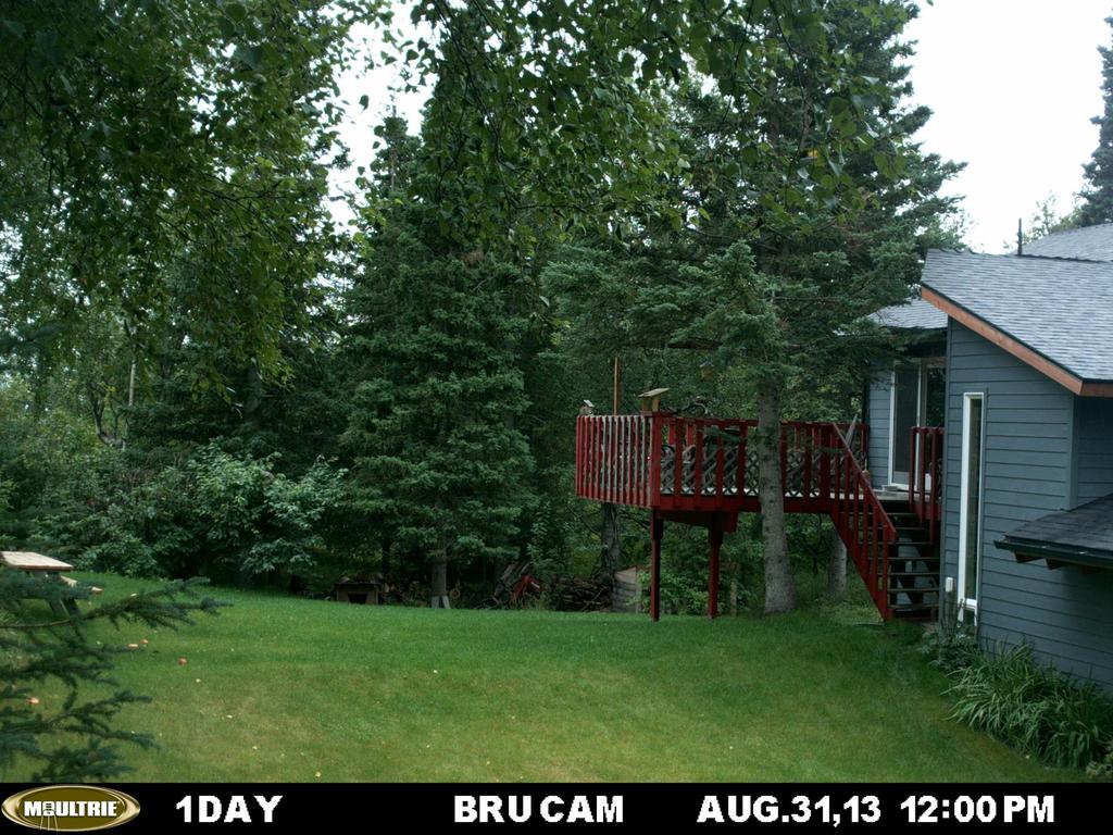
14 PILOT POINT Contact: Nikki Shannigan Environmental Coordinator, Native Village of Pilot Point Camera 1 - installed: October 11, 2012 (Moultrie) Installed by: Mike Brubaker, Jennifer Skarada Location: Utility Pole along Bay Road View: Road and shore line looking north. Topics: shore erosion, road conditions, sea ice, flooding, vegetation, weather. Nikki Shannigan and a friend. Photo by M. Brubaker

15 Shot Orientation Camera Location Photo by Mike Brubaker
16 The following slides provide an overview of the project sites and currently in active in the project. PILOT POINT Contact: Nikki Shannigan Environmental Coordinator, Native Village of Pilot Point Camera 2 - installed: October 11, 2012 (Moultrie) Installed by: Mike Brubaker, Jennifer Skarada Location: Utility Pole at bulkhead View: shoreline looking northeast. Topics: shore erosion, sea ice, flooding, vegetation, weather.

17 Shot Orientation Camera Location Photo by Mike Brubaker

18 NONDALTON Contact: Ron Loftfield, Community Health Aide, Bristol Bay Area Health Corporation Installed: July 24, 2013 (Moultrie) Installed by: Mike Brubaker, Ron Loftfield Location: Satellite base adjacent to tribal council offices. View: lakeshore north Topics: lake conditions, flooding, ice, vegetation, weather Ron Loftfield completing installation. Photo by M. Brubaker

19 Nondalton Camera View Photo by Mike Brubaker

20 LEVELOCK Contact: Greg Andrew Administrator, Levelock Village Council Installed: July 26, 2013 (Moultrie) Installed by: Mike Brubaker, Greg Andrew Location: Steel I beam on bulkhead View: river bank southwest, Newhalen River Topics: river conditions, erosion, flooding, ice, vegetation, weather Greg Andrew preparing for installation. Photo by M. Brubaker

21 Levelock Camera Location Photo by Mike Brubaker

22 Levelock Camera View Photo by Mike Brubaker

 View: Town Southwest, Golovin Bay and Golovin Lagoon Topics: flooding, ice,")
23 GOLOVIN Contact: Toby Anungazuk Jr. Environmental Coordinator, Chinik Eskimo Community Installed: September 2013 (Wingscape) Installed by: Toby Anungazuk Jr. Location: Bluff near graveyard (?) View: Town Southwest, Golovin Bay and Golovin Lagoon Topics: flooding, ice, vegetation, weather Toby Anungazuk Jr. Photo by Anahma Shannon
24 Golovin Camera View Photo by Mike Brubaker
 Installed")

25 GOLOVIN Contact: Michelle Snowball Environmental Coordinators, St. Michael Traditional Council Installed: October 4, 2013 (Wingscape) Installed by: Toby Anungazuk Jr. Location: Near tribal council office View: Topics: flooding, ice, vegetation, weather Michelle Snowball and Aide Cheemuk. Photo by Mike Brubaker

26


27 The take home The Northern environment is changing very quickly. Monitoring change is important for understanding impacts. Local observers provide knowledge and capacity. Time lapse cameras are one approach to monitor change. LEO Network is helping to install stop action cameras. This project is helping to raise awareness and understanding. For more information
Tidal Datums & Coastal Profiles. DGGS Coastal Hazards Program - Fairbanks, AK Program Manager: Nicole Kinsman
 Tidal Datums & Coastal Profiles DGGS Coastal Hazards Program - Fairbanks, AK Program Manager: Nicole Kinsman nicole.kinsman@alaska.gov 907-451-5026 Overview AOOS-funded DGGS Projects: 1) Port Heiden Short-Term
RESTORE Act Bucket 2 Planning Public Meeting
 RESTORE Act Bucket 2 Planning Public Meeting James C. Gibeaut, Ph.D. Coastal and Marine Geospatial Sciences Harte Research Institute for Gulf of Mexico Studies Texas A&M University Corpus Christi Public
TOPOGRAPHIC MAPS A NEW WAY TO VIEW THE WORLD!
 TOPOGRAPHIC MAPS A NEW WAY TO VIEW THE WORLD! http://courtneyjennings.weebly.com/unit-4---weathering-erosiontopo-maps-past.html A topographic map, simply put, is a two-dimensional representation of a portion
CineMoco v2.0. anual
 CineMoco v2.0 anual Table of Contents 1 Introduction 2 Hardware 3 User Interface 4 Menu Status Bar General (GEN) Controller (CON) Motor (MTR) Camera (CAM) 5 Recording Modes 6 Setup Styles 7 Move Types
Strete to Limpet Rocks 6b75 and 6b76 SUMMARY OF PREFERRED PLAN RECOMMENDATIONS AND JUSTIFICATION
 Location reference: Policy Unit reference: Plan: Strete to Limpet Rocks 6b75 and 6b76 SUMMARY OF PREFERRED PLAN RECOMMENDATIONS AND JUSTIFICATION The coastline is characterised by vegetated sea cliffs,
Northern Pass. Transmission Project: Visual Simulations. The THE NORTHERN PASS SM. MAY 2011_v2
 The Northern Pass Transmission Project: Visual Simulations THE NORTHERN PASS SM Northern Pass PO Box 330 780 North Commercial Street Manchester, NH 03105-0330 800-286-7305 www.northernpass.us MAY 2011_v2
The Impact of Climate Change on the Torres Strait and Australia s Indian Ocean Territories
 30 March 2010 The Impact of Climate Change on the Torres Strait and Australia s Indian Ocean Territories Gavin Briggs Manager Northern Australia Research Programme Summary The impact of climate change
Hi-resolution Data in a Low-resolution Landscape:
 Hi-resolution Data in a Low-resolution Landscape: Squeezing More Value from Digital Airphotos when Ancillary Data are Lacking Andrew Balser, October 17, 2008 Airphotos versus Satellite Imagery: Trade-offs
March 15, Karlyn Eckman, U of M Water Resources Center Mark Hauck, DNR Mary Blickenderfer, MN Extension Steve Henry, East Otter Tail SWCD
 March 15, 2012 Karlyn Eckman, U of M Water Resources Center Mark Hauck, DNR Mary Blickenderfer, MN Extension Steve Henry, East Otter Tail SWCD Additional funding provided by Itasca County Environmental
THE CORPORATION OF THE MUNICIPALITY OF SHUNIAH A G E N D A
 THE CORPORATION OF THE MUNICIPALITY OF SHUNIAH A G E N D A Special Meeting of Council June 2, 2015 COUNCIL ROAD AND INFRASTRUCTURE TOUR Commencing in Council Chambers at 420 Leslie Ave Travelling through
Roberts Bank Terminal 2 Project Field Studies Information Sheet
 May 2013 Port Metro Vancouver is continuing field studies in May as part of ongoing environmental and technical work for the proposed Roberts Bank Terminal 2 Project. Roberts Bank Terminal 2 Project The
Northeast Florida Coastal Wetland Restoration Program A Partnership Based Regional Approach for Estuary Habitat Restoration
 Northeast Florida Coastal Wetland Restoration Program A Partnership Based Regional Approach for Estuary Habitat Restoration Paul Haydt Restore America s Estuaries November 15, 2010 St Johns River Water
Guide to Developing a Stream Photograph Documentation Program
 Guide to Developing a Stream Photograph Documentation Program William Robertson: MSUEWQ & BSWC Introduction Landscape photographs can offer a qualitative and, in some situations, quantitative evaluation
Lower Rice Lake, the major wild rice-producing lake on the White Earth Reservation: Historic to Present Water Levels NASA- Kiksapa Summer REU
 Lower Rice Lake, the major wild rice-producing lake on the White Earth Reservation: Historic to Present Water Levels Lainey Fineday White Earth Tribal and Community College 2011 NASA- Kiksapa Summer REU
KySat1 Mission Review
 KySat1 Mission Review http://www.kysat.com KySat Conference Four Points Sheraton Lexington, Kentucky 3 May 2007 Presentation Overview Mission Objectives KySat Ground Segment KySat Background Standout Differences
The Philippines SHARE Program in Aerial Imaging
 The Philippines SHARE Program in Aerial Imaging G. Tangonan, N. Libatique, C. Favila, J. Honrado, D. Solpico Ateneo Innovation Center This presentation is about our ongoing aerial imaging research in the
IMAGES FROM ICELAND DANIEL BERGMANN PHOTOGRAPHY
 IMAGES FROM ICELAND DANIEL BERGMANN PHOTOGRAPHY Newsletter # 2 June 2009 AS WINTER PASSES AND SUMMER ARRIVES It doesn t get fully dark here in Iceland in winter, we re not far north enough for that, but
Eastern Lake Ontario Dunes D-3 Assessment SLELO-PRISM Buckthorn and Swallow-wort Surveillance/Dune Willow Monitoring
 St. Lawrence Eastern Lake Ontario Partnership for Regional Invasive Species Management Eastern Lake Ontario Dunes D-3 Assessment Buckthorn and Swallow-wort Surveillance/Dune Willow Monitoring July 13 &
Measuring Currents from Aids-to-Navigation Buoys
 Measuring Currents from Aids-to-Navigation Buoys Recent Design Improvements Bob Heitsenrether Kate Bosley, PhD Kasey Hall Overview CO-OPS Background NOAA s Physical Oceanographic Real-time System (PORTS
New Jersey Dept. of Environmental Protection Shore Protection Program
 New Jersey Dept. of Environmental Protection Benjamin Keiser, Manager 1510 Hooper Avenue, Suite 140 Toms River, New Jersey 08753 1-732-255-0767 New Jersey s State of New Jersey Chris Christie, Governor
Technology and Market Intelligence
 Technology and Market Intelligence Introduction into Training Fraunhofer IAO, IAT University of Stuttgart Slide 1 Background TMR is a component of the SIRIM-Fraunhofer programs. TMR strives to support
User Manual User manual0708.indd /7/11 2:57:27 PM
 User manual0708.indd 1 2008/7/11 2:57:27 PM Package Contents 1- BirdWatchCam 2- Mounting unit (Comes attached to the BirdWatchCam) 3-2 Rubber straps 4- Measuring tape 5- User manual 6-2 GB SD Card 7-4
Coastal. (Russia) Abstract. problem sections. South of. by suffers from. erosion. This. is partly due. Kaliningrad coastal tourism.
 Abstract. problem sections. South of. by suffers from. erosion. This. is partly due. Kaliningrad coastal tourism.") Sterr, Maack & Schultz (eds.): Development Concept for the Territory of the Baltic Green Belt - A Synthesis Report of the INTERREG IVB Project Baltic Green Belt. Coastline Reports 20 (2012), ISSN 0928-2734,
Sterr, Maack & Schultz (eds.): Development Concept for the Territory of the Baltic Green Belt - A Synthesis Report of the INTERREG IVB Project Baltic Green Belt. Coastline Reports 20 (2012), ISSN 0928-2734,
A A Well Engineer s s Perspective
 Mining Institute of Scotland IOM 3 Petroleum and Drilling Engineering Division Material Challenges for North Sea Oil & Gas Production A A Well Engineer s s Perspective ITF Advanced Materials Workshop Steve
Birds and Water in the Arid West: Habitats in Decline
 Birds and Water in the Arid West: Habitats in Decline Lotem Taylor, Chad Wilsey, Nicole Michel, Karyn Stockdale National Audubon Society Colorado River Reflection CanyonlandsNPS/Flickr Audubon s Report
Black Lake SLELO-PRISM Water Chestnut & Hydrilla Surveillance 2012
 St. Lawrence Eastern Lake Ontario Partnership for Regional Invasive Species Management Black Lake Water Chestnut & Hydrilla Surveillance 2012 June 8, 11, 12 & 14 (Water Chestnut); August 8 (Hydrilla),
Flood risk assessment in the Nemunas River delta area of Lithuania: a case study
 Flood risk assessment in the Nemunas River delta area of Lithuania: a case study By Vytautas Dubra, Petras Grecevičius Institute of Maritime and Cultural Landscapes, Klaipeda University, Lithuania Abstract
MDWFP Aerial Waterfowl Survey Report. January 3-6, 2018
 MDWFP Aerial Waterfowl Survey Report January 3-6, 2018 Prepared by: Houston Havens Waterfowl Program Coordinator and Alec Conrad Private Lands Biologist Delta Region MS Department of Wildlife, Fisheries,
Relationship Between Landsat 8 Spectral Reflectance and Chlorophyll-a in Grand Lake, Oklahoma
 Relationship Between Landsat 8 Spectral Reflectance and Chlorophyll-a in Grand Lake, Oklahoma Presented by: Abu Mansaray Research Team Dr. Andrew Dzialowski (PI), Oklahoma State University Dr. Scott Stoodley
User Manual.
 www.brinno.com User Manual Package Contents 1- BirdWatchCam 2- Mounting unit 3-2 Rubber straps 4- Measuring tape 5- User manual 6-2 GB SD Card 7-4 AA batteries Brinno Incorporated s BirdWatchCam User
Lesson 1: The Eastern Woodlands
 Lesson 1 Summary Lesson 1: The Eastern Woodlands Use with pages 76 80. Vocabulary tribe a group of families bound together under a single leadership; often used to describe people who share a common culture
2009 Assessment of Dune Movement Near Keeler, California
 April 16, 2010 2009 Assessment of Dune Movement Near Keeler, California Prepared by HydroBio for Great Basin Unified Air Pollution Control District Abstract Dune movement in the northeast corner of Owens
second story, which was used for sleeping space. Mats and wood screens
 mats and sheets of birchbark. The frame can be shaped like a dome, like a cone, or like a rectangle with an arched roof. Once the birchbark is in place, ropes or strips of wood are wrapped around the wigwam
AEC Board of Directors
 AEC Board of Directors Gary Jett District 1 Mark Isom District 2 Vice-President Gail Hickman Vacant Eric Fritz District 3 Dale Fain President District 6 District 8 Sue McBee District 4 John Austin Secretary-Treasurer
National Park Service Beach Access Report for July 31, 2008
 National Park Service U.S. Department of the Interior Outer Banks Group: Cape Hatteras National Seashore Fort Raleigh National Historic Site Wright Brothers National Memorial 1401 National Park Road Manteo,
Online Resources: KEY FEATURES
 Explore key features of online Earth science data tools that can be useful for K 12 student investigations. Sources are color coded for relative level/ease-of-use: BLUE (introductory); ORANGE (intermediate)
Silver Lake Glossy Buckthorn Field Report. September-October 2012
 Silver Lake Glossy Buckthorn Field Report September-October 2012 Submitted by George Spak and Sandra Bonanno Introduction/Background Silver Lake is a spring fed glacial pothole in western Oswego County.
>.A9>+).6! Welcome New Board of Governors Members. Contents:
.6! Welcome New Board of Governors Members. Contents:") >.A9>+).6! E:*/9'?!O:(3*5'!:.A9*:':7?! Contents: Page 1 Ponsella Hardaway, Doug Craven and Don Nugent join the GLLA Board of Governors page 3 Page 2 Page 3 Page 4 Page 5 We thank the outgoing
>.A9>+).6! E:*/9'?!O:(3*5'!:.A9*:':7?! Contents: Page 1 Ponsella Hardaway, Doug Craven and Don Nugent join the GLLA Board of Governors page 3 Page 2 Page 3 Page 4 Page 5 We thank the outgoing
Snowy owl numbers far lower than once thought 21 December 2017, by Tammy Webber
 Snowy owl numbers far lower than once thought 21 December 2017, by Tammy Webber In this Dec. 14, 2017 photo a snowy owl stares prior being released along the shore of Duxbury Beach in Duxbury, Mass. The
Radio Frequency Sensing from Space
 Radio Frequency Sensing from Space Edoardo Marelli ITU-R WP 7C Chairman ITU-R Seminar Manta (Ecuador) 20 September 2012 Why observing the Earth from space? Satellites orbiting around the Earth offer an
COMMUNICATIONS FOR MARITIME SAFETY AND EFFICIENCY. Francis Zachariae, Secretary-General, IALA
 COMMUNICATIONS FOR MARITIME SAFETY AND EFFICIENCY Francis Zachariae, Secretary-General, IALA IALA and its Purpose Non profit, international technical association established in 1957 Two Goals aimed at
I-45 INNOVATIVE TECHNOLOGY IN CONSTRUCTION
 I-45 INNOVATIVE TECHNOLOGY IN CONSTRUCTION Fernando Pizarro Quintanar, P.E. Area Manager, Webber James Kennedy Sr. Project Manager, Webber PRESENTATION OUTLINE WHY INNOVATION IN CONSTRUCTION? WHAT MAIN
Rural Alaska Community Environmental Job Training (RACEJT) Program Potential Assistance with Travel Funding and Other Job Training Needs
 Program Potential Assistance with Travel Funding and Other Job Training Needs") Rural Alaska Community Environmental Job Training (RACEJT) Program Potential Assistance with Travel Funding and Other Job Training Needs Regional Resource List RACEJT course tuition and materials are provided
Rural Alaska Community Environmental Job Training (RACEJT) Program Potential Assistance with Travel Funding and Other Job Training Needs Regional Resource List RACEJT course tuition and materials are provided
The Marine Managed Areas Inventory of the United States
 The Marine Managed Areas Inventory of the United States The National Marine Protected Areas Center Dan Farrow, MMA Inventory Coordinator Wednesday, June 25, 2003 Overview MMA Inventory Basics Status of
Hawksview Wetlands. Table Top Public School
 Hawksview Wetlands Table Top Public School Creative Catchment Kids Creative Catchment Kids is an initiative of Wirraminna Environmental Education Centre. It aims to improve engagement between our funding
Project Title: Migration patterns, habitat use, and harvest characteristics of long-tailed ducks wintering on Lake Michigan.
 Sea Duck Joint Venture Annual Project Summary FY 2016 (October 1, 2015 to Sept 30, 2016) Project Title: Migration patterns, habitat use, and harvest characteristics of long-tailed ducks wintering on Lake
Food and fibre. Introduction
 Food and fibre Introduction The Australian Curriculum addresses learning about food and fibre production in two ways: in content descriptions as in F 6/7 HASS/Geography, Science and Technologies, noting
Sea Duck Joint Venture Annual Project Summary for Endorsed Projects FY 2010 (October 1, 2009 to Sept 30, 2010)
") Sea Duck Joint Venture Annual Project Summary for Endorsed Projects FY 2010 (October 1, 2009 to Sept 30, 2010) Project Title: SDJV # 117 Population Delineation, Migratory Connectivity and Habitat Use of
Sea Duck Joint Venture Annual Project Summary for Endorsed Projects FY 2010 (October 1, 2009 to Sept 30, 2010) Project Title: SDJV # 117 Population Delineation, Migratory Connectivity and Habitat Use of
Bald Eagles Productivity Summary Lake Clark National Park and Preserve Cook Inlet Coastline
 Bald Eagles Productivity Summary 1994-1996 Lake Clark National Park and Preserve Cook Inlet Coastline Introduction: Although the bald eagle (Haliaeetus leucocephalus)is not listed as endangered or threatened
County Wetlands Board Minutes. July 8, 2008
 County Wetlands Board Minutes July 8, 2008 Call to Order The July 8, 2008 meeting of the Middlesex County Wetlands Board was called to order by Chairman Miller Smither at 9:00 A.M. in the Boardroom of
Derbyshire Derwent Catchment Partnership 14/07/2017. Adam Cormack, Head of Communications The Wildlife
 Derbyshire Derwent Catchment Partnership 14/07/2017 Adam Cormack, Head of Communications The Wildlife Trusts @everydaycormack The Wildlife Trusts Engagement and action the ingredients Who our audiences.
ESA IAP Blue Belt demonstration project:
 Page 1 ESA IAP Blue Belt demonstration project: supporting the European Maritime Safety Agency (EMSA) Blue Belt Project, by providing a service based on satellite based AIS data complementing the terrestrial
CHAPTER 144. Interpretation of Shoreline Position from Aerial Photographs John S. Fisher 1 Margery F. Overton 2
 CHAPTER 144 Interpretation of Shoreline Position from Aerial Photographs John S. Fisher 1 Margery F. Overton 2 Abstract A review of some of the potential sources of error associated with the use of aerial
DOWNLOAD OR READ : OAK BLUFFS THE COTTAGE CITY YEARS ON MARTHA 39 S VINEYARD MA IMAGES OF AMERICA PDF EBOOK EPUB MOBI
 DOWNLOAD OR READ : OAK BLUFFS THE COTTAGE CITY YEARS ON MARTHA 39 S VINEYARD MA IMAGES OF AMERICA PDF EBOOK EPUB MOBI Page 1 Page 2 oak bluffs the cottage city years on martha 39 s vineyard ma images of
Protecting biodiversity at Great Salt Lake. On the ground at Kennecott Utah Copper
 Protecting biodiversity at Great Salt Lake On the ground at Kennecott Utah Copper The procedures used and the success realised should serve as examples for future wetland mitigation planning. Association
6/13/03 RKLD Aquatic Vegetation Survey USGS Gage msl Location: GPS Point 164, westernmost shoreline stake of Quadrant D, Carcajou Shallow
 6/13/03 RKLD Aquatic Vegetation Survey USGS Gage - 776.31 msl Location: GPS Point 164, westernmost shoreline stake of Quadrant D, Carcajou Shallow Marsh Lake Study plot. Elevation 776.14 msl. 6/13/03 RKLD
Chaumont Bay SLELO-PRISM Water Chestnut & Hydrilla Surveillance 2012
 St. Lawrence Eastern Lake Ontario Partnership for Regional Invasive Species Management Chaumont Bay & Hydrilla Surveillance 2012 July 3, 5, 6 & 10 (Water Chestut); August 9 & 13 (Hydrilla), 2012 Figure
Some Relationships Between Fall Hawk Migration and Weather Features at High Park, Toronto
 78 Some Relationships Between Fall Hawk Migration and Weather Features at High Park, Toronto Donald W. Barnett The annual fall migration of diurnal raptors over High Park, Toronto, Ontario has been monitored
Ramsar Convention. LI To know and understand the purpose of the Ramsar Convention
 Ramsar Convention LI To know and understand the purpose of the Ramsar Convention Warm Up Change the following statements so they are appropriate for a report: 1 2 3 4 5 We conducted a beach survey last
Case Study The San Diego Blue Economy
 Case Study The San Diego Blue Economy Greg Murphy Executive Director www.themaritimealliance.org President Blue Economy Strategies GRMurphy@gmail.com NACo Presentation December 5, 2018 www.themaritimealliance.org
A c c e s s t o C o p e r n i c u s E M S m a p p i n g
 A c c e s s t o C o p e r n i c u s E M S m a p p i n g Copernicus Service Copernicus EU Copernicus EU Copernicus EU www.copernicus.eu W h o c a n u s e t h e S e r v i c e? There are three distinct user
CONSTRUCTION BEGINS ON $17 MILLION CAREER TECHNOLOGY CENTER
 Contact: Joe Verkennes, Director of Marketing, (734) 384-4207 May 4, 2012 FOR IMMEDIATE RELEASE CONSTRUCTION BEGINS ON $17 MILLION CAREER TECHNOLOGY CENTER MONROE, Mich. Construction officially began today
Cape Nome, Alaska excavation records
 1155 Finding aid prepared by Elizabeth Kelly. Last updated on March 01, 2017. University of Pennsylvania, Penn Museum Archives 3/6/13 Table of Contents Summary Information...3 Biography/History...4 Scope
The time lapse video you were watching before we started this presentation was made by DAVID PEARCE of the Hardy Orchid Society and obtained for us
 The time lapse video you were watching before we started this presentation was made by DAVID PEARCE of the Hardy Orchid Society and obtained for us by Stephen Pickersgill many thanks 1 Contents What is
erosion control HasTec KGW 400 advantages: usage: For surface protection and greening of slopes in landscaping and traffic route engineering.
 HasTec KGW 400 For surface protection and greening of slopes in landscaping and traffic route engineering. Surface covered with HasTec KGW 400. Fixing with nails of wood or steel (suggestion: 2-4 pieces
Royal Canadian Mounted Police Port Hardy Detachment There are no on-site emergency medical facilities in Holberg.
 PART 4.3 HOLBERG 4.3.1 Overview Holberg is located on Holberg Inlet which has access to the Pacific Ocean on the west coast of Vancouver Island. Population is approximately 100 persons, with the village
Monitoring, and first steps to tackling illegal killing of birds. Vicky Jones BirdLife International
 Monitoring, and first steps to tackling illegal killing of birds Vicky Jones BirdLife International Background Useful baseline from review, but good to repeat at intervals 25 million birds estimated to
SUMMARY REPORT AND RECOMMENDATIONS ON THE PREVENTION OF MARINE OIL POLLUTION IN THE ARCTIC.
 Arctic Council Open Access Repository Arctic Council http://www.arctic-council.org/ 1.8 Sweden Chairmanship I (May 2011 - May 2013) 4. SAO Meeting, March 2013, Stockholm, Sweden SUMMARY REPORT AND RECOMMENDATIONS
Minnesota Department of Natural Resources
 Minnesota Department of Natural Resources Fisheries Management VERSION - PRELIMINARY DATA (AS OF //4) Lake Name: Ocheda Survey Type: Winter Kill Assessment DOW Number: -4- Survey ID Date: //4 Lake Identification
UPPER MISSISSIPPI RIVER RESTORATION LAKE ODESSA HABITAT REHABILITATION AND ENHANCEMENT PROJECT OPERATION AND MAINTENANCE MANUAL APPENDIX F
 UPPER MISSISSIPPI RIVER RESTORATION LAKE ODESSA HABITAT REHABILITATION AND ENHANCEMENT PROJECT OPERATION AND MAINTENANCE MANUAL APPENDIX F PROJECT PHOTOGRAPHS Table of Photographs Photograph 1: Lake Odessa
Public Hearing. Preliminary Draft Development Plans Cay Hill- Little Bay & Cul de Sac
 Public Hearing Preliminary Draft Development Plans Cay Hill- Little Bay & Cul de Sac Development plan SXM September 2012 Welcome by the initiator of this public hearing Minister Maurice Lake: Ministry
Survey Protocol for the Yellow-billed Cuckoo Western Distinct Population Segment
 Survey Protocol for the Yellow-billed Cuckoo Western Distinct Population Segment Halterman, MD, MJ Johnson, JA Holmes, and SA Laymon. 2016. A Natural History Summary and Survey Protocol for the Western
A discussion on the paper Digital repeat photography for phenological research in forest ecosystems
 A discussion on the paper Digital repeat photography for phenological research in forest ecosystems Oliver Sonnentag et al., 2012 Zhang Wenqing 2017/10/06 Outline uintroduction umethods uresults and discussion
Arctic Shipping Navigating the Legal Landscape for marine infrastructure and Off-Shore Development
 Arctic Shipping Navigating the Legal Landscape for marine infrastructure and Off-Shore Development Peter G. Pamel Partner Connecticut Maritime Association SHIPPING 2012 Hilton Stamford March 21 st, 2012
Effective Conservation Photography. Tools and Tips from Bill Pielsticker, President PhotoMidwest (Formerly Center for Photography at Madison)
") Effective Conservation Photography Tools and Tips from Bill Pielsticker, President PhotoMidwest (Formerly Center for Photography at Madison) Copyright 2014 What ground will we cover? Technique Lighting
Effective Conservation Photography Tools and Tips from Bill Pielsticker, President PhotoMidwest (Formerly Center for Photography at Madison) Copyright 2014 What ground will we cover? Technique Lighting
Guide to Catholic-Related Records in the West about Native Americans See User Guide for help on interpreting entries
 Guide to Catholic-Related Records in the West about Native Americans See User Guide for help on interpreting entries Diocese of Fairbanks new 2006 ALASKA, FAIRBANKS Diocese of Fairbanks Archives W-13 1316
CLYDE MAP 2: CARDROSS to west of DUMBARTON TOWN
 CLYDE MAP 2: CARDROSS to west of DUMBARTON TOWN Hinterland Geology and Coastal Geomorphology: Raised beach deposits overlie undifferentiated glacial till. The shoreline is irregular and comprises a large
Special Habitats In Greene County
 Special Habitats In Greene County What does Greene County have in common with these animals.. That need special grassland habitat to survive? Or these That need special wetland habitat to survive? We have
The Global Cryosphere Watch
 The Global Cryosphere Watch Jeff Key NOAA, Madison, Wisconsin USA EC-PHORS GCW Task Team Lead 2 nd Asia CryoNet Meeting, Salekhard, Russia, February 2016 1 The cryosphere collectively describes elements
Glimpsed views through to site. Haywood Wood The site
 NB: ll views consist of one or more photographs taken with a Canon EOS 5dII digital camera fitted with a 50mm lens, forming a panorama. Copyright Savills (UK) Limited Glimpsed views through to site View
Calidris alpina schinzii Baltic/SW Europe & NW Africa
 Period 2008-2012 European Environment Agency European Topic Centre on Biological Diversity Calidris alpina schinzii Baltic/SW Europe & NW Africa Annex I International action plan Yes No Dunlin, Calidris
Jackson Bottom Wetlands Preserve BCS Number: 47-14
 Jackson Bottom Wetlands Preserve BCS Number: 47-14 Site description author(s) Greg Gillson, Jackson Bottom Wetlands Preserve Primary contact for this site Ed Becker, Natural Resources Manager, Jackson
Type E Botulism in Michigan An Overview
 Type E Botulism in Michigan An Overview Lake Erie Millennium Network 5 th Biennial Conference April 30, 2008 Mark Breederland Michigan Sea Grant Extension Traverse City, MI breederl@msu.edu Presentation
Rural Alaska Community Environmental Job Training (RACEJT) Program Potential Assistance with Travel Funding and Other Job Training Needs
 Program Potential Assistance with Travel Funding and Other Job Training Needs") Rural Alaska Community Environmental Job Training (RACEJT) Program Potential Assistance with Travel Funding and Other Job Training Needs Regional Resource List RACEJT course tuition and materials are provided
Rural Alaska Community Environmental Job Training (RACEJT) Program Potential Assistance with Travel Funding and Other Job Training Needs Regional Resource List RACEJT course tuition and materials are provided
 TO: ORIGIN: DATE: SUBJECT: The Chairman and Members of the Board of Directors, North Bay-Mattawa Conservation Authority Sue Buckle, Supervisor, Communications and Outreach June 28, 2017 Board Meeting Communications
POPULATION SIZE AND REPRODUCTIVE SUCCESS OF CALIFORNIA GULLS AT MONO LAKE, CALIFORNIA, IN 1995, WITH EMPHASIS ON THE NEGIT ISLETS
 POPULATION SIZE AND REPRODUCTIVE SUCCESS OF CALIFORNIA GULLS AT MONO LAKE, CALIFORNIA, IN 1995, WITH EMPHASIS ON THE NEGIT ISLETS W. David Shuford and Al DeMartini Report of Point Reyes Bird Observatory
Palm Beach County. Estuarine Habitat Mapping
 Palm Beach County Estuarine Habitat Mapping Coastal Habitat Integrated Mapping and Monitoring Program (CHIMMP) April 29, 2014 Eric Anderson, Environmental Analyst Palm Beach County Department of Environmental
Discovery Meeting Notes
 Project Name: Meeting: Date and Time: Island of Guam Discovery Meeting June 1, 2012 @ 9:00 AM Place: WebEx Call in Number: 1 866 203 6896 Conference Code: 6231479850 Discovery Meeting Notes 1. Introductions
Youngstown City Schools Preschool Curriculum Map Science I: Introduce September October November See Curriculum Model. Youngstown City Schools
 September October November See Curriculum Model Instructional Practices Physical Observation of Objects and Materials Objects and materials are described by their properties. Color, shape, size, weight
Delivering Subsea Solutions Using a Systems Engineering Approach
 Delivering Subsea Solutions Using a Systems Engineering Approach William Kilpatrick, PhD, CEng MIMechE February 2018 Agenda 1. Frazer-Nash Consultancy Overview i. Systems Engineering 2. Using a Systems
Birding Information for Photographers DPI- SIG 5/9/2013
 Birding Information for Photographers DPI- SIG 5/9/2013 Title: Finding the Birds by Arthur Sissman & Ron Perkins 20 minutes I. Factors to Consider Tides (Charts) Water - Fresh, Salt, Brackish Habitat Time
DetailedShoreChange at Chesapeake BayDune Systems. C.S.Hardaway,Jr. D.A.Milligan K.Farnsworth S. Dewing
 DetailedShoreChange at Chesapeake BayDune Systems C.S.Hardaway,Jr. D.A.Milligan K.Farnsworth S. Dewing November 2001 Detailed Shore Change at Chesapeake Bay Dune Systems by C. S. Hardaway, Jr. D. A. Milligan
The SandBox. Lesson 2 Water Flow Intermediate
 The SandBox Lesson 2 Water Flow Intermediate NSF award #OIA-1208927 1 Lesson 2 Water Flow Intermediate Lesson Summary: Objectives: Estimated Time: Students learn about erosion and deposition. They will
2011 Environmental & Photography Workshop Display
 2011 Environmental & Photography Workshop Display What is the Koala's favourite food tree? How do I photograph the feeling of being in the bush? Some of the questions answered for participants at our first
Post Point Heron Colony
 Post Point Heron Colony Monitoring Annual Report 2006 prepared for: The Department of Public Works 2221 Pacific Street Bellingham, WA 98226 prepared by: Ann Eissinger Wildlife Services PO Box 176 Bow,
Communication & Safety at Sea
 Ocean Signal Ltd. Unit 4, Ocivan Way Margate CT9 4NN United Kingdom info@oceansignal.com +44 1843 282930 Communication & Safety at Sea Introducing Ocean Signal The Range Ocean Signal specialises in the
Determining Wintering Areas and Migrations Routes of Red-throated Loons (Gavia stellata) in Atlantic Offshore Waters Using Satellite Tracking
 in Atlantic Offshore Waters Using Satellite Tracking") Determining Wintering Areas and Migrations Routes of Red-throated Loons (Gavia stellata) in Atlantic Offshore Waters Using Satellite Tracking Red-throated Loon (Gavia stellata) released with satellite
Determining Wintering Areas and Migrations Routes of Red-throated Loons (Gavia stellata) in Atlantic Offshore Waters Using Satellite Tracking Red-throated Loon (Gavia stellata) released with satellite
Ladd Marsh Wildlife Area BCS number: 49-3
 Oregon Coordinated Aquatic Bird Monitoring: Description of Important Aquatic Bird Site Ladd Marsh Wildlife Area BCS number: 49-3 Site description author M. Cathy Nowak, Ladd Marsh Wildlife Area Biologist
Marine Weather Program
 Marine Weather Program Shipping Federation of Canada Marine Workshop 2018 Montreal daniel.huang@canada.ca Meteorological Service of Canada Jan 31, 2018 ECCC is actively adapting its marine weather observing
Irina SMIRNOVA, Alexandra RUSANOVA
 Irina SMIRNOVA, Alexandra RUSANOVA Monitoring of Landscape Changes Due to Petroleum Fields Exploitation, Construction of Oil Pipelines and Oil Terminal in the Northern Part of the Timan-Pechorian Petroleum