Orthorectified imagery is widely
|
|
|
- Alfred Cain
- 5 years ago
- Views:
Transcription
1 Geometric Quality Assessment of Or By Simon Kay, Peter Spruyt, Abstract Two QuickBird images delivered in basic and standard processed formats and an IKOOS Geo-processed image, covering an area of 108km 2 near to Aradippou, Cyprus, were orthorectified using a Digital levation Model derived from medium scale map data and off-the-shelf software. The resulting orthoimages were tested for geometric correction quality using a standardized protocol. A network of ground control points (GCPs) was surveyed using a dual-frequency carrier-phase Global Positioning System receiver, with an estimated accuracy of better than 0.1m. The GCPs were divided into two sets: a calibration set (of 18 points) was used for a repetitive orthocorrection trial using between one and four GCPs, and a validation set (of 28 points) was used to evaluate the precision of each orthoimage. The system corrected Standard QuickBird image delivered by the supplier was found to meet the documented specification of 14m RMS, and is suitable for medium scale mapping applications. The upper 95% confidence limits of the one-dimensional RMS of orthoimages made from IKOOS Geo and QuickBird Basic images were 1.65 and 1.27 meters respectively: Both systems are well within 1:10,000 scale Class I accuracy requirements of the U Common Agricultural Policy. Orthorectified imagery is widely recognized as a data source for a variety of thematic mapping applications; in the uropean Union (U), information systems for the management of the Common Agricultural Policy are now routinely based upon digital orthophoto coverage with a nominal geometric quality of 1:10,000 map scale equivalent and a 1m pixel size, or better (Kay et al., 1997). evertheless, airborne image acquisition demands a certain degree of access that is not always feasible, and the availability of so-called very high resolution (VHR) satellite sensors permits the acquisition of data with image content quality characteristics aimed at the demands of rural area or agricultural mapping and monitoring (Petrie, 2002). Three main approaches for producing orthoimagery from QuickBird and IKOOS data are in current use: rigorous sensor models (for example, Toutin and Cheng, 2003), the Rational Polynomial Coefficient (RPC) method computed using ground control points, or the use of RPC information provided by image vendors. The first two require the use of substantial numbers of ground control points (typically 7 to 39, for different orders of correction), while the last may in theory function without any new ground control (Cheng, pers. comm., Dial and Grodecki, 2002; see Toutin, 2003 for a review of geometric correction approaches). While the above studies mostly demonstrate results of a very precise nature, we consider that for large area applications such as those initiated by the uropean Commission the use of more than a few points per image would render the widespread use of current VHR satellite imaging systems uneconomical, due to the relatively small scene footprint. Furthermore, any requirement to use a very precise terrain model would again pre-suppose the existence of high quality mapping, a consideration that would place many areas in urope outside the scope of application. The use of a limited amount of ground control has been attempted previously to improve the geocoding of IKOOS imagery (see Kaichang et al, 2003), and this is the philosophy that we have followed. The purpose of this study, therefore, was to evaluate the geometric quality of orthorectified QuickBird and IKOOS imagery, for a typical agricultural area, using a restricted number of high precision ground control points (GCP) and a medium-scale externally-derived digital elevation model (DM). For the purposes of this test, the Cyprus Ministry of Agriculture Table 1: Images used in the study. The two QuickBird images are identical in terms of acquisition characteristics but are processed to different levels. Both the IKOOS and QuickBird images present moderate off-nadir viewing that is typically selected for space mapping applications. Instrument QuickBird QuickBird IKOOS Product Type Standard Basic Geo Sensor elevation angle Pixel size 0.70 cm, resampled Ground sampling distance 0.62m/0.61m Resampled 1m (Ground Sampling Distance 0.83m) Date of acquisition May 2003 PHOTOGRAMMTRIC GIRIG & RMOT SSIG

2 thorectified VHR Space Image Data and Kyriacos Alexandrou acquired a QuickBird image with the characteristics shown in Table 1; we also received an IKOOS image of the same scene for comparison. In addition, the digitization of the 25m contour from the 1:50,000 national mapping series was undertaken to provide elevation data of adequate quality, nominally with an accuracy of 1/3 rd of the contour interval, or around 8m Root Mean Square rror (RMS) (ASPRS, 1989) in elevation. The technical work that followed consisted of: Selection of GCPs and field survey work using dual-frequency carrier-phase GPS; The creation of the DM, from the contour lines, using GIS software, and subsequent quality control; Assessment of the delivered Standard QuickBird image product geometric quality; Image orthorectification, using off-the-shelf software, of the three image types under test; Geometric quality assessment, using guidelines developed for use in uropean Commission project work. This article describes each of the five elements in turn. orthoimage products (uropean Commission, 1999). These guidelines provide a standardized approach for the quality testing of orthorectified imagery, derived from either airborne or spaceborne sensors, and have been used by our organization in a number of previous operational studies. In particular, we applied the approach for the testing by external quality control of orthoimage products, which is the more general method among those outlined in the guidelines. The QuickBird Standard scene was divided into 25 sections, with the objective of acquiring two GCPs in each section (a target of 50 GCPs in total); a diagram of the GCP positions is given in Figure 1. Candidate points were identified on large scale print-outs of the QuickBird Standard image in preparation for the field visit, and their continued on page 486 General Description of the Test Site and Images The location of the test site is in Cyprus, near the city of Larnaca, centred on the village of Aradippou. The scene extent covered by all images was just over 100km 2, and the zone is typical for agricultural regions in Cyprus with differences in relief of around 250m over the test site. The QuickBird image was acquired following normal ordering procedures, and delivered as both basic and standard corrected products (see Table 1). The former product is corrected for radiometric and sensor characteristics, but has no geometric corrections applied; the latter product, by contrast, is geometrically corrected to a nominal accuracy of 14m one-dimensional RMS 1, using a coarse DM (1km spacing), and projected into UTM using the WGS84 ellipsoid. However, the image product geometric specification does not account for relief displacement (urimage, 2003). The IKOOS image was provided as a Geo product, the lowest processing level of product available from the supplier 2. These data are processed into a system projection, in this case UTM projection and WGS84 ellipsoid (Space Imaging urasia, 2003). All three images were supplied with vendor-produced rational function data files (see Kaichang et al., 2003), and these were used as the primary means of orthocorrection. Ground Control Point Survey and Measurement A number of high precision control points were measured during a field mission conducted from 16 th -23 rd September 2002, throughout the test zone. The selection procedure was carried out using a set of guidelines adopted by the uropean Commission for testing of Figure 1: Distribution of ground control points used for calibration (red) and validation (green) overlaid on the QuickBird image of 21 June The grid shows the partitioning of the scene into equal sized areas, to ensure that the distribution of these points was well spread over the scene. The GCP selection was done on-screen, and printed documents produced to aid the exact survey of the points in the field. PHOTOGRAMMTRIC GIRIG & RMOT SSIG May
3 Definition of Root-Mean-Square rror When checking the geometry of orthoimagery, a measurement is required that can take into account the positive and negative values of the recorded residual errors. ormally, a simple averaging or mean value would give a result close to zero, without any indication of the size of the residuals observed. For this reason, mapping science generally uses the root-meansquare rror, or RMS, which gives an objective indication of the goodness of fit of the image to the check points. The RMS is, literally, the square root of the mean of the sum of the squares of the error residuals. The residuals are squared, to change them all to positive signed values, and then averaged; by taking the square root of this average, we get a single figure that describes the residuals behavior in a standardized manner. The form of the equation often used (for example, ASPRS 1989) is: where n is number of check points observed and d 1 to d n represent the check point residuals. However, classical textbook theory states that, for the interpretation to be generalized to a statistical statement for all populations (and not just that under test), the mean should be computed using (n-1) and not n. The RMS roughly and conveniently corresponds to the 1-σ level in statistics, i.e., around 68% of the residuals observed in an image would be expected to be less than the RMS, with the remainder being worse. Sometimes in statistical testing it is useful to estimate the 90%, 95% or 99% levels, and these can be approximated by multiplying the RMS value by 1.65, 1.96, or 2.58, respectively (Kachigan, 1991). Map Scales and Map Class Map scales can be broadly classified by two characteristics: their geometric quality and their information content. When producing orthoimagery, both are of primary consideration, and are related to the radiometric quality of the image (number and type of bands) and the image resolution. In practice, the two characteristics are highly correlated, an orthoimage of high information content usually capable of meeting a similar quality geometric product specification. We have adopted the term Class 1, originally used in a draft ASPRS scheme, to describe an orthoimage product that has an information content broadly compatible with its geometric quality. An image with a high level information content, but a lower geometric quality content, is described by us as having a Class 2 quality description. A good example in this study is the QuickBird Standard product after our rectification, which clearly has the information content of a typical 1:10,000 scale product but for which the geometric classification is closer to a 1:20,000 map (better than 5m RMS). In this study, we have focused upon the geometric quality of the images: it is necessary still that we evaluate the information content of these images for the agricultural scope of our application in more detail, and this will be part of a future study. Analysis of Variance Analysis of Variance, or AOVA, is a common statistical tool used to analyze datasets for which we are interested in evaluating the importance of several factors at once. In essence, the principles of AOVA are the same as those for the comparison of two datasets using the well-known Student s t-test, but for which the application is extended to groups of three or more datasets (in our case two kinds of QuickBird rectification and one IKOOS dataset, or different numbers of GCPs used in that rectification process). Both these tests examine the significance of the differences of the mean values of each dataset, with respect to the variability of the observations (in our case, RMS estimates) measured for that dataset. Furthermore, several factors can be tested at the same time, such as in our experiment where we have tested the number of GCPs used in parallel with the type of image used. More complicated experiments where the effect of factors such as test site, DM quality, and so forth, could be incorporated into the design. continued from page 485 approximate positions located on a medium-scale navigation plan of the area. The selection was limited to well-defined points, visible on the image during preparation for the field phase, with examples given in Figure 2a-b. Our guidelines for orthoimage quality control stipulate that ground control points must have an accuracy specification three times better than the orthoimage product specification, the latter established in this case as 2.5 m RMS (Kay et al., 1997, uropean Commission, 1999). It was thus necessary to acquire points with an RMS of better than 0.8m; in practice this is most reliably achieved with the use of carrierphase GPS equipment. A 12-channel dual frequency carrier phase system was used, together with associated post-processing software. The goal was reliable measurement of points with better than decimeter accuracy. For this project, GPS survey baselines were relatively short (less than 15km): nevertheless, GCP occupation times of up to 15 minutes were made, in order to ensure that uncertainty in the GPS positioning was eliminated as a factor in the image geometry assessment. All survey work was carried out in the WGS84 system, using the UTM projection (zone 36). It can be seen from Table 2 that the repositioning of the check reference points was very successful, with no planimetric error exceeding 0.07m. One survey point (Piagina) produced a significant elevation error with respect to the survey documentation, but still within the acceptable error of the project survey requirements. We thus concluded that we were able to locate GCPs within the local reference system with the decimeter horizontal accuracy targeted for the study. GPS measurement of GCPs was performed using the same equipment as mentioned above. Out of the planned 50 points, four (points 5, 8, 19, 22) were abandoned due to access problems. However, each of the 25 sections had at least one GCP that was successfully measured. 486 May 2003 PHOTOGRAMMTRIC GIRIG & RMOT SSIG
 and IKOOS (January 2002, right image), and the survey photograph.")

. The same survey standard was used for the GCPs collected for testing image correction accuracy.")

 and then converted to a 25m grid using ArcGIS 8.0 (SRI, 2003).")

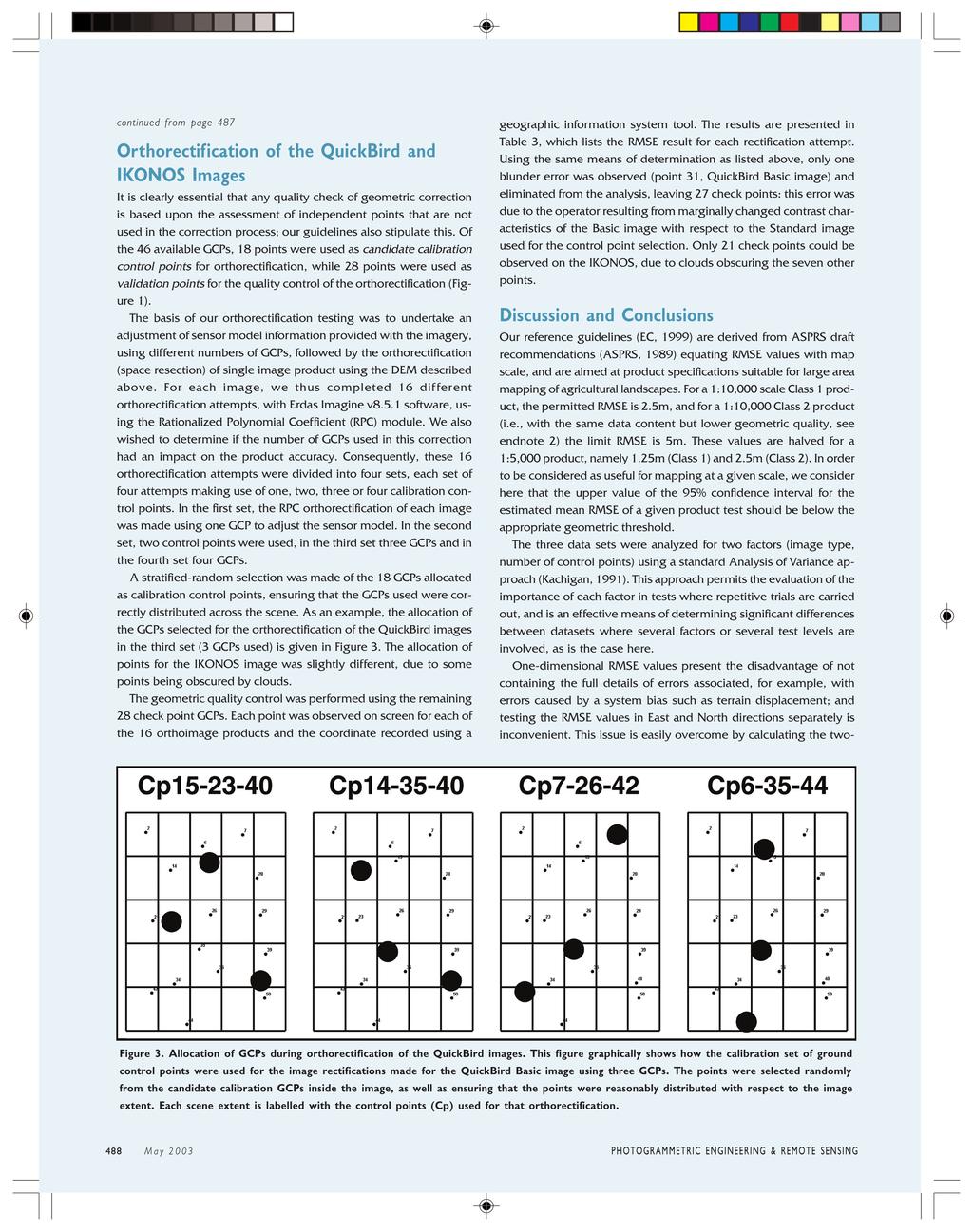
4 Figure 2a. Figure 2b. Figure 2. xamples of ground control point locations, with the image sub-sections taken from QuickBird (June 2002, left image) and IKOOS (January 2002, right image), and the survey photograph. GCP selection was made exclusively from well defined points on the QuickBird image. Some differences between the QuickBird and IKOOS images can be observed; it should be recalled that the images were acquired six months apart. Table 2. Base station check points. The results presented in this table show that the location of surveyed check points, when compared to positions in the official national survey network, have horizontal residual errors better than decimetre accuracy (maximum error 0.07m). The same survey standard was used for the GCPs collected for testing image correction accuracy. asting (m) orthing (m) MSL levation (m) d (m) d (m) dz (m) Alona Arradipou Diplopotamos n/a n/a Mouti_Farangou Survey point Piagina Quality Control of DM and Delivered QuickBird Standard Image The DM was derived from digitized contour lines with an interval of 25 meters, extracted from the national 1:50,000 map series. The contour lines were transformed into a triangulated irregular network (TI) and then converted to a 25m grid using ArcGIS 8.0 (SRI, 2003). The surveyed GCPs were superimposed on the raster grid, and the Mean Sea Level (MSL) elevation value selected from the corresponding pixel in the DM. The residual result between the DM elevation and the surveyed elevation was then calculated on all 46 measured GCPs; the result obtained was less than 5m RMS, confirming the suitability of the DM for production of an orthorectified image with a nominal 1:10,000 scale, in accordance with our guidelines. All 46 GCPs were used for an initial assessment of the delivered Standard corrected image product; the position for each point was observed in the image and the coordinates (asting, orthing) compared with those collected by GPS, and the residual differences computed. Following the uropean Commission quality assessment guidelines, blunder errors were defined as points with a residual of more than three times the RMS of observed data set; however, no blunder errors were identified and all check points validated. The quality of the delivered Standard corrected image was thus estimated as RMS 6.89 m, RMS 8.70 m, on the basis of these 46 independent points. This is well inside the specified accuracy of the QuickBird Standard product; as expected, however, it is insufficient to meet the geometric demands of our application and so a full orthorectification with the use of ground control is required. This was the next step in our study. continued on page 488 PHOTOGRAMMTRIC GIRIG & RMOT SSIG May
5
6 Table 3. Results of RMS computed for each orthoimage. Orthocorrection was based upon the use of one or more calibration GCPs, and up to 28 validation GCPs. The one-dimensional (either ast or orth) RMS value was calculated from the residuals observed on the validation points. From these results it is possible to estimate the mean expected RMS when using between one and four calibration GCPs, for each of the three image types. QB Standard QB Basic IKOOS 1 GCP RMS RMS 1 GCP RMS RMS 1 GCP RMS RMS GCP RMS RMS 1 GCP RMS RMS 1 GCP RMS RMS GCP RMS RMS 1 GCP RMS RMS 1 GCP RMS RMS GCP RMS RMS 1 GCP RMS RMS 1 GCP RMS RMS dimensional RMS, so the residual data, measured and presented in the Table 3 as a one-dimensional RMS value in either the orthing or asting directions, were converted to a two-dimensional RMS (RMS 2D ) using the formula: An initial two-factor AOVA analysis of the RMS 2D residual showed that both the number of GCPs used and the image type were significant factors (>99.9% level). Inspection of the results (Figure 4, page 490) revealed an important difference for the QuickBird Standard image that we had rectified, which clearly produced a lower quality orthoimage product compared to the other two images. However, the rectification approach applied does not substantially alter the relief displacement corrections already made during the Standard processing of the data by the image provider, using a coarse DM: consequently, the result of the corrections is broadly equivalent to a continued on page 490 PHOTOGRAMMTRIC GIRIG & RMOT SSIG May
7 continued from page 489 simple translation 3. Since the main result was outside our target specification of 1:10,000 Class 1 mapping, the data for this product were excluded from further analysis. A further two-factor (GCP, image type) AOVA was performed on the reduced data set of the QuickBird Basic image and the IKOOS Geo image; results were again significant for both factors. However, the interaction term (Kachigan, 1991) of the analysis was also very significant, again indicating that the result was dependent upon both the GCP numbers and the image type. Inspection of the results shows that for one GCP, the RMS obtained is more variable (Figure 5). Final results were then calculated on the basis of the data collected for image orthorectification using two, three or four GCPs only. In this mode, the difference in RMS 2D visible in Figure 4 between the products is still significant (p < ); however, no significant differences were computed for the number of GCPs used, implying that 2 or more points are suitable for obtaining a good correction. It should be noted that the results presented here are only statistically valid for the test site and image orthocorrection approaches (combinations of sensor, GCP and DM data) investigated; further work will be required to reliably determine the true performance potential of these spaceborne sensors in a broader context for the agricultural mapping application proposed. Additionally, the reported constraints of the RPC method with respect to image extent and method limitations (Toutin, 2003) need to be recognized. everthe- less, we believe that the results do indicate strongly the potential for both these imaging systems to produce mapping at the scale required for agricultural applications within the uropean Union. To Summarize, the results showed satisfactorily that: The external quality control approach applied helps the objective evaluation of geometric quality, and permitted the comparison of the different image data products on a single test site. The QuickBird Standard product delivered was inside the announced geometric specification of 14m RMS. The QuickBird Standard product, further rectified using the vendor supplied RPC data and 2 to 4 GCPs, remained outside the specification required for U rural area mapping (1:10,000 Class 1), with a mean one dimensional RMS of 2.72m and a RMS of 2.43m (maximum limit of the 95% confidence interval was 2.93m). However, a Class 2 specification (same information content, but with a 1:20,000 mapping scale equivalent) was easily achieved using this approach. A mean RMS of 1.60m and 1.13m, and mean RMS of 1.29m and 1.15m were observed for the IKOOS and QuickBird (Basic product) orthoimages respectively: a significant difference in the performance of the two systems was detected. The upper 95% confidence limit of the one-dimensional RMS of orthoimages made from IKOOS Geo and QuickBird Basic images were 1.65 and 1.27 meters respectively: Both systems are Figure 4. Plot of mean estimate of two dimensional RMS plotted by image type. The black diamond represents the mean value, and the error bars represent the 95% confidence interval for the estimate. Some suspected statistical outliers were identified in this analysis in nearly all cases these correspond to results obtained using just one GCP. It can clearly be seen that the QuickBird Basic and IKOOS orthoimage products were superior to that produced from the QuickBird Standard image. evertheless, the QuickBird Basic image produced the highest quality product in this test. Both the IKOOS and QuickBird Basic orthoimage products were well within the 1:10,000 Class 1 quality specification. Figure 5: Plot of two dimensional RMS variation with GCP number, QuickBird Basic and IKOOS Geo results combined. The black diamond represents the mean value, and the error bars represent the 95% confidence interval for the estimate. Only a weak decreasing trend is observed with an increase in the number of GCPs used: the slight increase in mean value (and variability) for the use of one GCP is due to the reduced reliability of operator precision when a single point is taken for control. The use of more than two GCPs is not considered worthwhile in order to meet the 1:10,000 Class 1 specification used for this application. 490 May 2003 PHOTOGRAMMTRIC GIRIG & RMOT SSIG
8 well within 1:10,000 scale Class I accuracy requirements of the U Common Agricultural Policy. For the orthorectified QuickBird basic product, the two-dimensional RMS result (mean 1.62, upper limit of 95% confidence interval 1.72m) was just inside the equivalent 1:5,000 Class 1 mapping requirement of 1.77m. However, the 1-D RMS exceeded the allowed error budget for this specification. A DM with 5m RMS (vertical) was sufficient to achieve orthocorrection within target specification for the conditions of this study (agricultural landscape, moderate sensor view angles). Increasing the number of ground control points from two to four made no significant difference to the quality of the correction result for either of the systems tested. It is recommended that more than one GCP is used, since errors in control point data cannot be compensated for or detected without any redundancy. Footnotes 1 For more information on Quickbird products see website: or For information on IKOOS products, see website: It should be noted that since this study was carried out, a new QuickBird Standard product destined for orthocorrection has been announced by Digital Globe. References ASPRS, ASPRS interim accuracy standards for large scale maps, Photogrammetric ngineering and Remote Sensing, 56: Dial, G., and Grodecki, J. (2002) IKOOS accuracy without ground control, Integrated Remote Sensing at the Global, Regional and Local Scale, ISPRS Commission I Mid-Term Symposium in conjunction with Pecora 15/Land Satellite Information IV Conference, ovember 2002, Denver, CO. ( pdf) SRI, urimage (2002). Products and Services catalogue, uropean Commission, (1999) Guidelines for Quality Checking of orthoimagery, Kachigan, S.K. (1991) Multivariate statistical analysis, Radius Press, ew York. Kaichang Di, Ruijin Ma, and Ron Li, Rational functions and potential for rigorous sensor model recovery, Photogrammetric ngineering and Remote Sensing, 69(1): Kay, S., Léo, O., Meyer Roux, J., Delincé, J, and Van de Steene, M. (1997), Operational activities involving airborne remote sensing related to the Common Agricultural Policy, Proceedings of the 3 rd International Airborne Remote Sensing Conference and xhibition, 7-10 July 1997, pp I Petrie, G., (2002) Optical Imagery from Airborne & Spaceborne Platforms: Comparisons of Resolution, Coverage & Geometry for a Given Ground Pixel Size, GeoInformatics, 5(1): Space Imaging urasia (2003) Online products catalogue, Toutin, T (2003), Geometric processing of remote sensing images: models, algorithms and methods, IJRS 25, (in press). Toutin, T, and Cheng, P., (2002) QuickBird a milestone for high resolution mapping, arth Observation Magazine, Vol. 11, o. 4. Acknowledgments The authors would like to thank the following persons who helped undertake this study: The anonymous reviewer, whose comments and suggestions much improved the submitted draft of the article; Livio Rossi, Bruno Biagini and Fabio Volpe of urimage for QuickBird image provision, technical advice and comments on the draft manuscript; iek Schaap, of Space Imaging urasia and Gene Dial, Jacek Grodecki and Adrian Zevenberger of Space Imaging, Inc. for their assistance in providing images, technical advice and comments on the draft manuscript; Thierry Toutin (CCRS, Canada) for information on image rectification approaches. Simon Kay, Peter Spruyt, and Kyriacos Alexandrou Mars Unit Institute for the Protection and Security of the Citizen, TP266 Joint Research Centre of the uropean Commission, Ispra (VA) Italy simon.kay@jrc.it, peter.spruyt@jrc.it Kyriacos Alexandrou Department of Agriculture, Ministry of Agriculture, atural Resources and nvironment icosia, Cyprus PHOTOGRAMMTRIC GIRIG & RMOT SSIG May
EVALUATION OF PLEIADES-1A TRIPLET ON TRENTO TESTFIELD
 EVALUATION OF PLEIADES-1A TRIPLET ON TRENTO TESTFIELD D. Poli a, F. Remondino b, E. Angiuli c, G. Agugiaro b a Terra Messflug GmbH, Austria b 3D Optical Metrology Unit, Fondazione Bruno Kessler, Trento,
RapidEye Initial findings of Geometric Image Quality Analysis. Joanna Krystyna Nowak Da Costa
 RapidEye Initial findings of Geometric Image Quality Analysis Joanna Krystyna Nowak Da Costa EUR 24129 EN - 2009 The mission of the JRC-IPSC is to provide research results and to support EU policy-makers
[GEOMETRIC CORRECTION, ORTHORECTIFICATION AND MOSAICKING]
![[GEOMETRIC CORRECTION, ORTHORECTIFICATION AND MOSAICKING]](/thumbs/78/78211997.jpg "[GEOMETRIC CORRECTION, ORTHORECTIFICATION AND MOSAICKING]") 2013 Ogis-geoInfo Inc. IBEABUCHI NKEMAKOLAM.J [GEOMETRIC CORRECTION, ORTHORECTIFICATION AND MOSAICKING] [Type the abstract of the document here. The abstract is typically a short summary of the contents
2013 Ogis-geoInfo Inc. IBEABUCHI NKEMAKOLAM.J [GEOMETRIC CORRECTION, ORTHORECTIFICATION AND MOSAICKING] [Type the abstract of the document here. The abstract is typically a short summary of the contents
Geometric Quality Testing of the WorldView-2 Image Data Acquired over the JRC Maussane Test Site using ERDAS LPS, PCI Geomatics and
 Geometric Quality Testing of the WorldView-2 Image Data Acquired over the JRC Maussane Test Site using ERDAS LPS, PCI Geomatics and Keystone digital photogrammetry software packages Inital Findings Joanna
Automatic geo-registration of satellite imagery
 Fjärranalysdagarna 10-11 mars 2009 Automatic geo-registration of satellite imagery Torbjörn Westin Lars-Åke Edgardh Ian Spence Spacemetric AB www.spacemetric.com Keystone Image Server Keystone is an automatic
TEMPORAL ANALYSIS OF MULTI EPOCH LANDSAT GEOCOVER IMAGES IN ZONGULDAK TESTFIELD
 TEMPORAL ANALYSIS OF MULTI EPOCH LANDSAT GEOCOVER IMAGES IN ZONGULDAK TESTFIELD Şahin, H. a*, Oruç, M. a, Büyüksalih, G. a a Zonguldak Karaelmas University, Zonguldak, Turkey - (sahin@karaelmas.edu.tr,
High Resolution Sensor Test Comparison with SPOT, KFA1000, KVR1000, IRS-1C and DPA in Lower Saxony
 High Resolution Sensor Test Comparison with SPOT, KFA1000, KVR1000, IRS-1C and DPA in Lower Saxony K. Jacobsen, G. Konecny, H. Wegmann Abstract The Institute for Photogrammetry and Engineering Surveys
Planet Labs Inc 2017 Page 2
 SKYSAT IMAGERY PRODUCT SPECIFICATION: ORTHO SCENE LAST UPDATED JUNE 2017 SALES@PLANET.COM PLANET.COM Disclaimer This document is designed as a general guideline for customers interested in acquiring Planet
DEM GENERATION WITH WORLDVIEW-2 IMAGES
 DEM GENERATION WITH WORLDVIEW-2 IMAGES G. Büyüksalih a, I. Baz a, M. Alkan b, K. Jacobsen c a BIMTAS, Istanbul, Turkey - (gbuyuksalih, ibaz-imp)@yahoo.com b Zonguldak Karaelmas University, Zonguldak, Turkey
Orthoimagery Standards. Chatham County, Georgia. Jason Lee and Noel Perkins
 1 Orthoimagery Standards Chatham County, Georgia Jason Lee and Noel Perkins 2 Table of Contents Introduction... 1 Objective... 1.1 Data Description... 2 Spatial and Temporal Environments... 3 Spatial Extent
EXAMPLES OF TOPOGRAPHIC MAPS PRODUCED FROM SPACE AND ACHIEVED ACCURACY CARAVAN Workshop on Mapping from Space, Phnom Penh, June 2000
 EXAMPLES OF TOPOGRAPHIC MAPS PRODUCED FROM SPACE AND ACHIEVED ACCURACY CARAVAN Workshop on Mapping from Space, Phnom Penh, June 2000 Jacobsen, Karsten University of Hannover Email: karsten@ipi.uni-hannover.de
News on Image Acquisition for the CwRS Campaign new sensors and changes
 Control Methods Workshop: 6-8 / 4 / 2009 [CwRS KO Meeting Campaign 2009] 1 News on Image Acquisition for the CwRS Campaign 2009 - new sensors and changes Pär Johan Åstrand, Joanna Nowak, Maria Erlandsson
Baldwin and Mobile Counties, AL Orthoimagery Project Report. Submitted: March 23, 2016
 2015 Orthoimagery Project Report Submitted: Prepared by: Quantum Spatial, Inc 523 Wellington Way, Suite 375 Lexington, KY 40503 859-277-8700 Page i of iii Contents Project Report 1. Summary / Scope...
TESTFIELD TRENTO: GEOMETRIC EVALUATION OF VERY HIGH RESOLUTION SATELLITE IMAGERY
 TESTFIELD TRENTO: GEOMETRIC EVALUATION OF VERY HIGH RESOLUTION SATELLITE IMAGERY G. AGUGIAROa, D. POLIb, F. REMONDINOa, 3DOM, 3D Optical Metrology Unit Bruno Kessler Foundation, Trento, Italy a b Vermessung
Geomatica OrthoEngine v10.2 Tutorial Orthorectifying ALOS PRISM Data Rigorous and RPC Modeling
 Geomatica OrthoEngine v10.2 Tutorial Orthorectifying ALOS PRISM Data Rigorous and RPC Modeling ALOS stands for Advanced Land Observing Satellite and was developed by the Japan Aerospace Exploration Agency
Image Fusion. Pan Sharpening. Pan Sharpening. Pan Sharpening: ENVI. Multi-spectral and PAN. Magsud Mehdiyev Geoinfomatics Center, AIT
 1 Image Fusion Sensor Merging Magsud Mehdiyev Geoinfomatics Center, AIT Image Fusion is a combination of two or more different images to form a new image by using certain algorithms. ( Pohl et al 1998)
IMAGE DATA AND TEST FIELD
 Georeferencing Accuracy of Ge With bias-corrected RPCs and a single GCP, the RMS georeferencing accuracy of GeoEye-1 stereo imagery reaches the unprecedented level of 0.10m (0.2 pixel) in planimetry and
RADIOMETRIC AND GEOMETRIC CHARACTERISTICS OF PLEIADES IMAGES
 RADIOMETRIC AND GEOMETRIC CHARACTERISTICS OF PLEIADES IMAGES K. Jacobsen a, H. Topan b, A.Cam b, M. Özendi b, M. Oruc b a Leibniz University Hannover, Institute of Photogrammetry and Geoinformation, Germany;
Geomatica OrthoEngine v10.2 Tutorial DEM Extraction of GeoEye-1 Data
 Geomatica OrthoEngine v10.2 Tutorial DEM Extraction of GeoEye-1 Data GeoEye 1, launched on September 06, 2008 is the highest resolution commercial earth imaging satellite available till date. GeoEye-1
DIFFERENTIAL APPROACH FOR MAP REVISION FROM NEW MULTI-RESOLUTION SATELLITE IMAGERY AND EXISTING TOPOGRAPHIC DATA
 DIFFERENTIAL APPROACH FOR MAP REVISION FROM NEW MULTI-RESOLUTION SATELLITE IMAGERY AND EXISTING TOPOGRAPHIC DATA Costas ARMENAKIS Centre for Topographic Information - Geomatics Canada 615 Booth Str., Ottawa,
REGISTRATION OF OPTICAL AND SAR SATELLITE IMAGES BASED ON GEOMETRIC FEATURE TEMPLATES
 REGISTRATION OF OPTICAL AND SAR SATELLITE IMAGES BASED ON GEOMETRIC FEATURE TEMPLATES N. Merkle, R. Müller, P. Reinartz German Aerospace Center (DLR), Remote Sensing Technology Institute, Oberpfaffenhofen,
INTEGRATED DEM AND PAN-SHARPENED SPOT-4 IMAGE IN URBAN STUDIES
 INTEGRATED DEM AND PAN-SHARPENED SPOT-4 IMAGE IN URBAN STUDIES G. Doxani, A. Stamou Dept. Cadastre, Photogrammetry and Cartography, Aristotle University of Thessaloniki, GREECE gdoxani@hotmail.com, katerinoudi@hotmail.com
CALIBRATION OF OPTICAL SATELLITE SENSORS
 CALIBRATION OF OPTICAL SATELLITE SENSORS KARSTEN JACOBSEN University of Hannover Institute of Photogrammetry and Geoinformation Nienburger Str. 1, D-30167 Hannover, Germany jacobsen@ipi.uni-hannover.de
GEOMETRIC RECTIFICATION OF EUROPEAN HISTORICAL ARCHIVES OF LANDSAT 1-3 MSS IMAGERY
 GEOMETRIC RECTIFICATION OF EUROPEAN HISTORICAL ARCHIVES OF LANDSAT -3 MSS IMAGERY Torbjörn Westin Satellus AB P.O.Box 427, SE-74 Solna, Sweden tw@ssc.se KEYWORDS: Landsat, MSS, rectification, orbital model
LPIS Orthoimagery An assessment of the Bing imagery for LPIS purpose
 LPIS Orthoimagery An assessment of the Bing imagery for LPIS purpose Slavko Lemajić Wim Devos, Pavel Milenov GeoCAP Action - MARS Unit - JRC Ispra Tallinn, 24 th November 2011 Outline JRC`s Ortho specifications
CanImage. (Landsat 7 Orthoimages at the 1: Scale) Standards and Specifications Edition 1.0
 Standards and Specifications Edition 1.0") CanImage (Landsat 7 Orthoimages at the 1:50 000 Scale) Standards and Specifications Edition 1.0 Centre for Topographic Information Customer Support Group 2144 King Street West, Suite 010 Sherbrooke, QC
CanImage (Landsat 7 Orthoimages at the 1:50 000 Scale) Standards and Specifications Edition 1.0 Centre for Topographic Information Customer Support Group 2144 King Street West, Suite 010 Sherbrooke, QC
Geomatica OrthoEngine V10.3 Tutorial. Orthorectifying AVNIR-2 Data Rigorous and RPC Modeling
 Geomatica OrthoEngine V10.3 Tutorial Orthorectifying AVNIR-2 Data Rigorous and RPC Modeling AVNIR-2 stands for Advanced Visible and Near Infrared Radiometer Type 2. It is a successor of AVNIR-1 and is
GeoBase Raw Imagery Data Product Specifications. Edition
 GeoBase Raw Imagery 2005-2010 Data Product Specifications Edition 1.0 2009-10-01 Government of Canada Natural Resources Canada Centre for Topographic Information 2144 King Street West, suite 010 Sherbrooke,
ENVI Tutorial: Orthorectifying Aerial Photographs
 ENVI Tutorial: Orthorectifying Aerial Photographs Table of Contents OVERVIEW OF THIS TUTORIAL...2 ORTHORECTIFYING AERIAL PHOTOGRAPHS IN ENVI...2 Building the interior orientation...3 Building the exterior
News on Image Acquisition for Campaign 2008
 Ispra, 3-4/04/2008 CwRS KO meeting 1 News on Image Acquisition for Campaign 2008 Pär Johan Åstrand, Maria Erlandsson, annian Zhu CID Action Ispra, 3-4/04/2008 CwRS KO meeting 2 Outline of presentation
processing VHR satellite imagery in Tsunami affected areas of Indonesia and Sri Lanka
 EUROPEAN COMMISSION DIRECTORATE GENERAL JRC JOINT RESEARCH CENTRE - ISPRA Institute for the Protection and Security of the Citizen Agriculture and Fisheries Unit JRC IPSC/G03/P/PSP/psp D(2005)(5091) /
Topographic mapping from space K. Jacobsen*, G. Büyüksalih**
 Topographic mapping from space K. Jacobsen*, G. Büyüksalih** * Institute of Photogrammetry and Geoinformation, Leibniz University Hannover ** BIMTAS, Altunizade-Istanbul, Turkey KEYWORDS: WorldView-1,
Geomatica OrthoEngine Orthorectifying SPOT6 data
 Geomatica OrthoEngine Orthorectifying SPOT6 data On September 9, 2012, SPOT 6 was launched adding to the constellation of Earthimaging satellites designed to provide 1.5m high-resolution data. The architecture
Evaluation of DEM, and orthoimage generated from Cartosat-1 with its potential for feature extraction and visualization
 American Journal of Remote Sensing 2013; 1(1) : 1-6 Published online February 20, 2013 (http://www.sciencepublishinggroup.com/j/ajrs) doi: 10.11648/j. ajrs.20130101.11 Evaluation of DEM, and orthoimage
Aerial photography: Principles. Frame capture sensors: Analog film and digital cameras
 Aerial photography: Principles Frame capture sensors: Analog film and digital cameras Overview Introduction Frame vs scanning sensors Cameras (film and digital) Photogrammetry Orthophotos Air photos are
Remote Sensing. The following figure is grey scale display of SPOT Panchromatic without stretching.
 Remote Sensing Objectives This unit will briefly explain display of remote sensing image, geometric correction, spatial enhancement, spectral enhancement and classification of remote sensing image. At
SPOT 5 / HRS: a key source for navigation database
 SPOT 5 / HRS: a key source for navigation database CONTENT DEM and satellites SPOT 5 and HRS : the May 3 rd 2002 revolution Reference3D : a tool for navigation and simulation Marc BERNARD Page 1 Report
Geopositioning Accuracy Assessment of GeoEye-1 Panchromatic and Multispectral Imagery
 Geopositioning Accuracy Assessment of GeoEye-1 Panchromatic and Multispectral Imagery Manuel A. Aguilar, Fernando J. Aguilar, María del Mar Saldaña, and Ismael Fernández Abstract Currently GeoEye-1 is
Abstract Quickbird Vs Aerial photos in identifying man-made objects
 Abstract Quickbird Vs Aerial s in identifying man-made objects Abdullah Mah abdullah.mah@aramco.com Remote Sensing Group, emap Division Integrated Solutions Services Department (ISSD) Saudi Aramco, Dhahran
PROPERTY OF THE LARGE FORMAT DIGITAL AERIAL CAMERA DMC II
 PROPERTY OF THE LARGE FORMAT DIGITAL AERIAL CAMERA II K. Jacobsen a, K. Neumann b a Institute of Photogrammetry and GeoInformation, Leibniz University Hannover, Germany jacobsen@ipi.uni-hannover.de b Z/I
LONG STRIP MODELLING FOR CARTOSAT-1 WITH MINIMUM CONTROL
 LONG STRIP MODELLING FOR CARTOSAT-1 WITH MINIMUM CONTROL Amit Gupta a, *, Jagjeet Singh Nain a, Sanjay K Singh a, T P Srinivasan a, B Gopala Krishna a, P K Srivastava a a Space Applications Centre, Indian
KOMPSAT-2 DIRECT SENSOR MODELING AND GEOMETRIC CALIBRATION/VALIDATION
 KOMPSAT-2 DIRECT SENSOR MODELING AND GEOMETRIC CALIBRATION/VALIDATION Doo Chun Seo a, *, Ji Yeon Yang a, Dong Han Lee a, Jeong Heon Song a, Hyo Suk Lim a a KARI, Satellite Information Research Institute,
1. Introduction 2. Tectonics of NE Iceland Krafla rifting crisis (constraints from spy image matching)
") 1. Introduction 2. Tectonics of NE Iceland 3. 1975-1984 Krafla rifting crisis (constraints from spy image matching) 4. 1975-1984 Krafla rifting crisis (constraints from aerial photos) 5. Conclusions Tuesday
1. Introduction 2. Tectonics of NE Iceland 3. 1975-1984 Krafla rifting crisis (constraints from spy image matching) 4. 1975-1984 Krafla rifting crisis (constraints from aerial photos) 5. Conclusions Tuesday
SAR Othorectification and Mosaicking
 White Paper SAR Othorectification and Mosaicking John Wessels: Senior Scientist PCI Geomatics SAR Othorectification and Mosaicking This study describes the high-speed orthorectification and mosaicking
GROUND CONTROL SURVEY REPORT
 GROUND CONTROL SURVEY REPORT Services provided by: 3001, INC. a Northrop Grumman company 10300 Eaton Place Suite 340 Fairfax, VA 22030 Ground Control Survey in Support of Topographic LIDAR, RGB Imagery
CALIBRATION OF IMAGING SATELLITE SENSORS
 CALIBRATION OF IMAGING SATELLITE SENSORS Jacobsen, K. Institute of Photogrammetry and GeoInformation, University of Hannover jacobsen@ipi.uni-hannover.de KEY WORDS: imaging satellites, geometry, calibration
Summary of the VHR image acquisition Campaign 2014 and new sensors for 2015
 Summary of the VHR image acquisition Campaign 2014 and new sensors for 2015 Michaela Neumann, George Ellis, Samuel Bärisch, Blanka Vajsova 19 November 2014, Dresden 20th MARS Conference Presentation Outline
DEMS BASED ON SPACE IMAGES VERSUS SRTM HEIGHT MODELS. Karsten Jacobsen. University of Hannover, Germany
 DEMS BASED ON SPACE IMAGES VERSUS SRTM HEIGHT MODELS Karsten Jacobsen University of Hannover, Germany jacobsen@ipi.uni-hannover.de Key words: DEM, space images, SRTM InSAR, quality assessment ABSTRACT
Geometric potential of Pleiades models with small base length
 European Remote Sensing: Progress, Challenges and Opportunities EARSeL, 2015 Geometric potential of Pleiades models with small base length Karsten Jacobsen Leibniz University Hannover, Institute of Photogrammetry
NUCLEAR WASTE RELATED SATELLITE MAPPING IN NORTHWEST RUSSIA
 NUCLEAR WASTE RELATED SATELLITE MAPPING IN NORTHWEST RUSSIA O. B.Dick a, *, O. Reistad b, S. Hustveit b, G. Grepstad c, Frits Steenhuisen d a Geomatics section - IMT, Norwegian University of Life Sciences,
Image Registration Issues for Change Detection Studies
 Image Registration Issues for Change Detection Studies Steven A. Israel Roger A. Carman University of Otago Department of Surveying PO Box 56 Dunedin New Zealand israel@spheroid.otago.ac.nz Michael R.
Fusion of Heterogeneous Multisensor Data
 Fusion of Heterogeneous Multisensor Data Karsten Schulz, Antje Thiele, Ulrich Thoennessen and Erich Cadario Research Institute for Optronics and Pattern Recognition Gutleuthausstrasse 1 D 76275 Ettlingen
Comparing geometric and radiometric information from GeoEye-1 and WorldView-2 multispectral imagery
 European Journal of Remote Sensing - 2014, 47: 717-738 doi: 10.5721/EuJRS20144741 Received 20/05/2014, accepted 17/10/2014 European Journal of Remote Sensing An official journal of the Italian Society
ASTER GDEM Readme File ASTER GDEM Version 1
 I. Introduction ASTER GDEM Readme File ASTER GDEM Version 1 The Advanced Spaceborne Thermal Emission and Reflection Radiometer (ASTER) Global Digital Elevation Model (GDEM) was developed jointly by the
Digital database creation of historical Remote Sensing Satellite data from Film Archives A case study
 Digital database creation of historical Remote Sensing Satellite data from Film Archives A case study N.Ganesh Kumar +, E.Venkateswarlu # Product Quality Control, Data Processing Area, NRSA, Hyderabad.
HD aerial video for coastal zone ecological mapping
 HD aerial video for coastal zone ecological mapping Albert K. Chong University of Otago, Dunedin, New Zealand Phone: +64 3 479-7587 Fax: +64 3 479-7586 Email: albert.chong@surveying.otago.ac.nz Presented
THREE-DIMENSIONAL MAPPING USING BOTH AIRBORNE AND SPACEBORNE IFSAR TECHNOLOGIES ABSTRACT INTRODUCTION
 THREE-DIMENSIONAL MAPPING USING BOTH AIRBORNE AND SPACEBORNE IFSAR TECHNOLOGIES Trina Kuuskivi Manager of Value Added Products and Services, Intermap Technologies Corp. 2 Gurdwara Rd, Suite 200, Ottawa,
CHARACTERISTICS OF VERY HIGH RESOLUTION OPTICAL SATELLITES FOR TOPOGRAPHIC MAPPING
 CHARACTERISTICS OF VERY HIGH RESOLUTION OPTICAL SATELLITES FOR TOPOGRAPHIC MAPPING K. Jacobsen Leibniz University Hannover, Institute of Photogrammetry and Geoinformation jacobsen@ipi.uni-hannover.de Commission
PROCEDURE FOR GNSS EQUIPMENT VERIFICATION IN STATIC POSITIONING
 M. Tsakiri, V. Pagounis, V. Zacharis Procedure for GNSS equipment verification in static positioning PROCEDURE FOR GNSS EQUIPMENT VERIFICATION IN STATIC POSITIONING Maria TSAKIRI, School of Rural and Surveying
Correcting topography effects on terrestrial radar maps
 Correcting topography effects on terrestrial radar maps M. Jaud, R. Rouveure, P. Faure, M-O. Monod, L. Moiroux-Arvis UR TSCF Irstea, National Research Institute of Science and Technology for Environment
Keywords: Agriculture, Olive Trees, Supervised Classification, Landsat TM, QuickBird, Remote Sensing.
 Classification of agricultural fields by using Landsat TM and QuickBird sensors. The case study of olive trees in Lesvos island. Christos Vasilakos, University of the Aegean, Department of Environmental
SCIENCE & TECHNOLOGY
 Pertanika J. Sci. & Technol. 21 (2): 387-396 (2013) SCIENCE & TECHNOLOGY Journal homepage: http://www.pertanika.upm.edu.my/ Production of Orthophoto and Volume Determination Using Low-Cost Digital Cameras
HIGH RESOLUTION COLOR IMAGERY FOR ORTHOMAPS AND REMOTE SENSING. Author: Peter Fricker Director Product Management Image Sensors
 HIGH RESOLUTION COLOR IMAGERY FOR ORTHOMAPS AND REMOTE SENSING Author: Peter Fricker Director Product Management Image Sensors Co-Author: Tauno Saks Product Manager Airborne Data Acquisition Leica Geosystems
The Radar Ortho Suite is an add-on to Geomatica. It requires Geomatica Core or Geomatica Prime as a pre-requisite.
 Technical Specifications Radar Ortho Suite The Radar Ortho Suite includes rigorous and rational function models developed to compensate for distortions and produce orthorectified radar images. Distortions
Specifications for Post-Earthquake Precise Levelling and GNSS Survey. Version 1.0 National Geodetic Office
 Specifications for Post-Earthquake Precise Levelling and GNSS Survey Version 1.0 National Geodetic Office 24 November 2010 Specification for Post-Earthquake Precise Levelling and GNSS Survey Page 1 of
Ground Truth for Calibrating Optical Imagery to Reflectance
 Visual Information Solutions Ground Truth for Calibrating Optical Imagery to Reflectance The by: Thomas Harris Whitepaper Introduction: Atmospheric Effects on Optical Imagery Remote sensing of the Earth
ANALYSIS OF SRTM HEIGHT MODELS
 ANALYSIS OF SRTM HEIGHT MODELS Sefercik, U. *, Jacobsen, K.** * Karaelmas University, Zonguldak, Turkey, ugsefercik@hotmail.com **Institute of Photogrammetry and GeoInformation, University of Hannover,
Accurate, Detailed Elevation
 White Paper Accurate, Detailed Elevation LEVERAGE HIGH RESOLUTION SATELLITE STEREO IMAGERY TO DERIVE DETAILED, ACCURATE ELEVATION MODELS IN INNACCESSIBLE AREAS Dr. Waldir Paradella and Dr. Philip CHeng
THE IMAGE REGISTRATION TECHNIQUE FOR HIGH RESOLUTION REMOTE SENSING IMAGE IN HILLY AREA
 THE IMAGE REGISTRATION TECHNIQUE FOR HIGH RESOLUTION REMOTE SENSING IMAGE IN HILLY AREA Gang Hong, Yun Zhang Department of Geodesy and Geomatics Engineering University of New Brunswick Fredericton, New
Processing of stereo scanner: from stereo plotter to pixel factory
 Photogrammetric Week '03 Dieter Fritsch (Ed.) Wichmann Verlag, Heidelberg, 2003 Bignone 141 Processing of stereo scanner: from stereo plotter to pixel factory FRANK BIGNONE, ISTAR, France ABSTRACT With
PLANET IMAGERY PRODUCT SPECIFICATIONS PLANET.COM
 PLANET IMAGERY PRODUCT SPECIFICATIONS SUPPORT@PLANET.COM PLANET.COM LAST UPDATED JANUARY 2018 TABLE OF CONTENTS LIST OF FIGURES 3 LIST OF TABLES 4 GLOSSARY 5 1. OVERVIEW OF DOCUMENT 7 1.1 Company Overview
switzerland Commission II, ISPRS Kyoto, July 1988
 TOWARDS THE DIGITAL FUTURE stefan Lutz Kern & CO.., Ltd 5000 Aarau switzerland Commission II, ISPRS Kyoto, July 1988 ABSTRACT The equipping of the Kern Digital stereo Restitution Instrument (DSR) with
Integrating Spaceborne Sensing with Airborne Maritime Surveillance Patrols
 22nd International Congress on Modelling and Simulation, Hobart, Tasmania, Australia, 3 to 8 December 2017 mssanz.org.au/modsim2017 Integrating Spaceborne Sensing with Airborne Maritime Surveillance Patrols
MSB Imagery Program FAQ v1
 MSB Imagery Program FAQ v1 (F)requently (A)sked (Q)uestions 9/22/2016 This document is intended to answer commonly asked questions related to the MSB Recurring Aerial Imagery Program. Table of Contents
Application of GIS to Fast Track Planning and Monitoring of Development Agenda
 Application of GIS to Fast Track Planning and Monitoring of Development Agenda Radiometric, Atmospheric & Geometric Preprocessing of Optical Remote Sensing 13 17 June 2018 Outline 1. Why pre-process remotely
UltraCam and UltraMap Towards All in One Solution by Photogrammetry
 Photogrammetric Week '11 Dieter Fritsch (Ed.) Wichmann/VDE Verlag, Belin & Offenbach, 2011 Wiechert, Gruber 33 UltraCam and UltraMap Towards All in One Solution by Photogrammetry ALEXANDER WIECHERT, MICHAEL
APCAS/10/21 April 2010 ASIA AND PACIFIC COMMISSION ON AGRICULTURAL STATISTICS TWENTY-THIRD SESSION. Siem Reap, Cambodia, April 2010
 APCAS/10/21 April 2010 Agenda Item 8 ASIA AND PACIFIC COMMISSION ON AGRICULTURAL STATISTICS TWENTY-THIRD SESSION Siem Reap, Cambodia, 26-30 April 2010 The Use of Remote Sensing for Area Estimation by Robert
Suveying Lectures for CE 498
 Suveying Lectures for CE 498 SURVEYING CLASSIFICATIONS Surveying work can be classified as follows: 1- Preliminary Surveying In this surveying the detailed data are collected by determining its locations
Chapter 1 Overview of imaging GIS
 Chapter 1 Overview of imaging GIS Imaging GIS, a term used in the medical imaging community (Wang 2012), is adopted here to describe a geographic information system (GIS) that displays, enhances, and facilitates
Option 1. Design Options are diverse e.g. new route alignments covering a wide area. Option 2. Design Options are restricted
 MINIMUM STANDARD Z/16 SURVEY SPECIFICATIONS 1. GENERAL This specification sets out the Consultant s requirements for topographical survey (ground and aerial) for the Detailed Business Case (DBC) and Pre-Implementation
Statistical Analysis of SPOT HRV/PA Data
 Statistical Analysis of SPOT HRV/PA Data Masatoshi MORl and Keinosuke GOTOR t Department of Management Engineering, Kinki University, Iizuka 82, Japan t Department of Civil Engineering, Nagasaki University,
Geomatica OrthoEngine v10.2 Tutorial DEM Extraction of WorldView-1 Data
 Geomatica OrthoEngine v10.2 Tutorial DEM Extraction of WorldView-1 Data WorldView 1, launched on September 18, 2007, offers a panchromatic imagery at a very high resolution of 50 cm at nadir. The key benefits
COMPARISON OF INFORMATION CONTENTS OF HIGH RESOLUTION SPACE IMAGES
 COMPARISON OF INFORMATION CONTENTS OF HIGH RESOLUTION SPACE IMAGES H. Topan*, G. Büyüksalih*, K. Jacobsen ** * Karaelmas University Zonguldak, Turkey ** University of Hannover, Germany htopan@karaelmas.edu.tr,
POTENTIAL OF HIGH-RESOLUTION INDIAN REMOTE SENSING SATELLITE IMAGERY FOR LARGE SCALE MAPPING
 POTENTIAL OF HIGH-RESOLUTION INDIAN REMOTE SENSING SATELLITE IMAGERY FOR LARGE SCALE MAPPING P.V. Radhadevi *, V.Nagasubramanian, Archana Mahapatra, S.S.Solanki, Krishna Sumanth & Geeta Varadan Advanced
Separation of crop and vegetation based on Digital Image Processing
 Separation of crop and vegetation based on Digital Image Processing Mayank Singh Sakla 1, Palak Jain 2 1 M.TECH GEOMATICS student, CEPT UNIVERSITY 2 M.TECH GEOMATICS student, CEPT UNIVERSITY Word Limit
School of Rural and Surveying Engineering National Technical University of Athens
 Laboratory of Photogrammetry National Technical University of Athens Combined use of spaceborne optical and SAR data Incompatible data sources or a useful procedure? Charalabos Ioannidis, Dimitra Vassilaki
Proceedings of Al-Azhar Engineering 7 th International Conference Cairo, April 7-10, 2003.
 Proceedings of Al-Azhar Engineering 7 th International Conference Cairo, April 7-10, 2003. MODERNIZATION PLAN OF GPS IN 21 st CENTURY AND ITS IMPACTS ON SURVEYING APPLICATIONS G. M. Dawod Survey Research
Remote sensing image correction
 Remote sensing image correction Introductory readings remote sensing http://www.microimages.com/documentation/tutorials/introrse.pdf 1 Preprocessing Digital Image Processing of satellite images can be
INFORMATION CONTENT ANALYSIS FROM VERY HIGH RESOLUTION OPTICAL SPACE IMAGERY FOR UPDATING SPATIAL DATABASE
 INFORMATION CONTENT ANALYSIS FROM VERY HIGH RESOLUTION OPTICAL SPACE IMAGERY FOR UPDATING SPATIAL DATABASE M. Alkan a, * a Department of Geomatics, Faculty of Civil Engineering, Yıldız Technical University,
Fiscal 2007 Environmental Technology Verification Pilot Program Implementation Guidelines
 Fifth Edition Fiscal 2007 Environmental Technology Verification Pilot Program Implementation Guidelines April 2007 Ministry of the Environment, Japan First Edition: June 2003 Second Edition: May 2004 Third
Chapter 6 GPS Relative Positioning Determination Concepts
 Chapter 6 GPS Relative Positioning Determination Concepts 6-1. General Absolute positioning, as discussed earlier, will not provide the accuracies needed for most USACE control projects due to existing
PREDICTING COMPACTION GROUT QUANTITIES IN SINKHOLE REMEDIATION
 PREDICTING COMPACTION GROUT QUANTITIES IN SINKHOLE REMEDIATION Edward D. Zisman Cardno ATC, 5602 Thompson Center Court, Suite 405, Tampa, Florida 34689 Abstract Predicting the required quantity of grout
PLANET IMAGERY PRODUCT SPECIFICATION: PLANETSCOPE & RAPIDEYE
 PLANET IMAGERY PRODUCT SPECIFICATION: PLANETSCOPE & RAPIDEYE LAST UPDATED OCTOBER 2016 SALES@PLANET.COM PLANET.COM Table of Contents LIST OF FIGURES 3 LIST OF TABLES 3 GLOSSARY 5 1. OVERVIEW OF DOCUMENT
(Presented by Jeppesen) Summary
 Summary") International Civil Aviation Organization SAM/IG/6-IP/06 South American Regional Office 24/09/10 Sixth Workshop/Meeting of the SAM Implementation Group (SAM/IG/6) - Regional Project RLA/06/901 Lima, Peru,
International Civil Aviation Organization SAM/IG/6-IP/06 South American Regional Office 24/09/10 Sixth Workshop/Meeting of the SAM Implementation Group (SAM/IG/6) - Regional Project RLA/06/901 Lima, Peru,
Update on Landsat Program and Landsat Data Continuity Mission
 Update on Landsat Program and Landsat Data Continuity Mission Dr. Jeffrey Masek LDCM Deputy Project Scientist NASA GSFC, Code 923 November 21, 2002 Draft LDCM Implementation Phase RFP Overview Page 1 Celebrate!
OVERVIEW OF KOMPSAT-3A CALIBRATION AND VALIDATION
 OVERVIEW OF KOMPSAT-3A CALIBRATION AND VALIDATION DooChun Seo 1, GiByeong Hong 1, ChungGil Jin 1, DaeSoon Park 1, SukWon Ji 1 and DongHan Lee 1 1 KARI(Korea Aerospace Space Institute), 45, Eoeun-dong,
Image Registration Exercise ESPM 5295
 Background: We often digitize data from orthorectifed aerial photographs. These photographs have been processed to remove tilt and terrain errors to the level practical and required by the original contract.
GEO/EVS 425/525 Unit 9 Aerial Photograph and Satellite Image Rectification
 GEO/EVS 425/525 Unit 9 Aerial Photograph and Satellite Image Rectification You have seen satellite imagery earlier in this course, and you have been looking at aerial photography for several years. You
Crop Area Estimation with Remote Sensing
 Boogta 25-28 November 2008 1 Crop Area Estimation with Remote Sensing Some considerations and experiences for the application to general agricultural statistics Javier.gallego@jrc.it Some history: MARS
Phased Array Velocity Sensor Operational Advantages and Data Analysis
 Phased Array Velocity Sensor Operational Advantages and Data Analysis Matt Burdyny, Omer Poroy and Dr. Peter Spain Abstract - In recent years the underwater navigation industry has expanded into more diverse