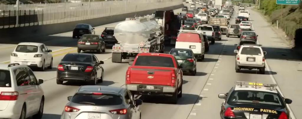
COST OF TRAFFIC US alone wasted about 3 billion gallons of fuel thanks to traffic in 2014, America blew through $160 billion in wasted time and fuel
|
|
|
- Gwenda Douglas
- 5 years ago
- Views:
Transcription
1
2 COST OF TRAFFIC US alone wasted about 3 billion gallons of fuel thanks to traffic in 2014, America blew through $160 billion in wasted time and fuel last year -- an average cost of $960 per typical motorist, according to the study. Delays cost commercial truckers even more. By 2020, TTI projects that the total nationwide delay time will grow to 8.3 billion hours -- an increase of 1.4 billion hours in just 5 years -- and congestion will cost $192 billion In 2013, more than 32,000 people died on U.S. roads, roughly 90 fatalities a day, according to the CDC.

3

4 America s drivers wasted 6.9 billion hours stuck in traffic in 2014, according to a study released by the Texas A&M Transportation Institute(TTI) and INRIX. That s 42 hours a year per rush-hour commuter on average.


5

6 ROADS VISION TECHNOLOGY Live Street Level Imagery
7 Street Level Imagery Street Level Imagery is imagery of roads Street level imagery is typically collected by car mounted cameras. Over the past decade, there have been numerous efforts to capture and deliver street-level imagery of major urban areas. The big players, Google Street View and Bing Map Street side, are well accepted, and most of us use them regularly to get around. and Apple Inc. has announced that it is creating a street view service as part of its Apple Maps service and HERE / TOMTOM / YANDEX and YAHOO MAP has their own street view.
8 But as they indicate in their user agreements, they are for entertainment and marketing and not intended for critical applications Annually this company and many other smaller company's was spending billions of dollars to creating Street Level Imagery. A growing number of automakers are now incorporating street view images technologies into their cars' navigation systems Street View, which gives drivers real-life photos of their destination to ensure they arrive at the right location, is already available on Audi / Mercedes / Toyota / Tesla / BMW / Hyundai and Kia. But they didn t provide live pictures or videos..


9


10


11 SIMPEL IS SIMPEL IS BEUTIFUL BEUTIFULE


12 Smartphones will be used as a platform for Street Level Imagery in Roads Vision applications. Using its GPS receiver, Inertial Measurement Unit (IMU), magnetometers and camera sensors, smartphones can be considered an ideal platform which contains all navigation and remote sensing sensors required for any Street Level Imagery.
13 Roads Vision Is community-based Street Level Imagery technology which streaming live video of the roads by drivers to its network, and its mission was share live videos of the roads to its users and also collect and analyze the traffic data accurately and efficiently; to provide user-friendly systems to access and view roads videos and traffic data including traffic volume, speed, vehicle classification, time headways bike and pedestrian counts, collision data, speed limit and traffic signs recognition and much more
14 Roads Vision Driver-to-Driver (D2D) Voice Communication Drivers need to coordinate with each other to share the road infra-structure. The social relationship between drivers also influences the driving behavior. With Roads Vision (D2D) available connectivity the relationship between drivers on the same road may gain more transparency, enabling necessary information to pass through the steel shell of the cars and giving opportunities to reduce anonymity and strengthen empathy as well as eliminate boredom, loneliness and stress. Imagine that a driver whose child is seized with a serious sickness asks for priority on the emergency lane or ask nearby drivers who is doctor for help.


15 13 Milliseconds: The Incredible Speed at Which Your Brain Can Identify an Image of traffic
16 ROADS VISION three main parts screenshot
17 Live video broadcast live video streaming and Street level imagery live video streaming system automatically sharing live video of the roads to ROADS VISION network of users and live street view Video Map to enable all user to search by location to see the roads condition and traffic. You can also Instantly share your live videos to Twitter and other social networks or broadcast privately to specific followers or friends and family. Cloud based Dash Cam and Black Box Online Dash Cam and Black Box recording capabilities for your car and vehicle journeys, in CLOUD recording of video, audio, GPS and G-Impact Sensor driving score and information on your journey including travel time, distance travelled, plus your average and top speeds.
18 traffic and navigation Navigation Live routing based on community driven, real-time traffic & road info Community alerts reported including accidents, hazards, police traps, road closures, and more Turn-by-turn voice guided ROADS VISION live Video Map search page Search roads to see Community live video alerts reported including accidents, hazards, police traps, road closures, Traffic and more in live video alerts page. Road assistance for driver safety Headway Monitoring and Warning Alerts drivers when car departs from lane Drunk-driving Prevention Traffic Sign Recognition
19 live video alerts You can see community and ROADS VISION live video alerts, including accidents, hazards, police traps, road closures, Traffic and more. This technology that lets you explore the cities roads through the eyes of other drivers. Driver can only see live video alerts when car was completely in stopped position.
20 Nobody give up from the safety
21 Roads Vision and cars driver are working together Traffic Sign Assist increases your safety and can save you from having to pay out money on fines. That's because it helps you to keep to the maximum permissible speed limit for the area you are in and alerts you to restrictions on overtaking. And should you ever be about to make a wrong turn into a road against the stipulated flow of traffic, Traffic Sign Assist can alert you when the appropriate signs are present via a warning in the on the Roads Vision Online display screen as well as an audible signal. The data gathered is compared in real time with information from the digital road maps stored in the Roads Vision Online System, so that the applicable speed limit can then be displayed on the Roads Vision Online display screen.


22

23 Dash cam Dash cams may provide video evidence in the event of an accident (Car black box)
24 Dash cams You Can Prevent Fraud Insurance fraud is one of the most common problems of the 21st century, when it comes to vehicles and traffic. Not only does the fraud affect insurance companies on a large scale, but it actually takes its toll on car drivers (the honest ones!) as well. Simply put, some drivers purposely cause car accidents just to put the blame on the other party, in order to extort money from the victim. This is a widely used fraud practice nowadays, where those who commit it usually look for high-end car drivers to extort. You Have First-Hand Evidence Of A Car Accident The dash cam is the strongest and most efficient proof you have for defending yourself, in case of car crash. In the end, it is better to have one and to stay on the safe side, as it can help you save a lot of time, money and trouble in the long run. You Can Record Your Entire Road Trip This reason is particularly important if you are fond of road trips and you always go with your loved ones on occasional trips. Do you want to turn your road trip into an unforgettable journey that you can see over and over again, whenever nostalgia kicks in? If so, then a dashboard camera is certainly a great investment that will help you turn your road trip into a great experience and a memory you will cherish over the years.

25 Privacy concerns We are committed to protecting your privacy while collecting this data. For example, we will blur faces and license plates on collected images prior to publication

26

27 Live Street View, and Video Map Video Map can available as a component of Roads Vision as a web application, and as a mobile application for Android and ios
28 Roads Vision can acted as a Surveillance cameras Surveillance cameras are video cameras that observe an area. The system is useful in gathering a variety of data in daily life and disasters scenarios. According to the statistics, the use of surveillance cameras has dramatically increased over the last decade. In the US, for example, the Department of Homeland Security provides billions of dollars annually in Homeland Security grants for the agencies of all levels to install video surveillance equipment. Installing one surveillance camera cost more then $ to government and if include service and maintenance charge it will be more then this.
29 What makes our services so special and unique 1 Highly accurate traffic data in this day the only parameter you see in Google / INRIX or HERE map is average traffic sped in red or green line to indicate traffic condition of the roads and only WAZE application show some roads report in its map bot in our technology you can see live videos of the roads before stating your daily commute, Each driver will have access to near real-time info of road conditions, traffic data and various hazards that will help make better decision on the road during the driving on live map.
30 And while collaboration plays a huge part in each of these services, the difference between them is significant. ROADS VISION services are driven by data pooled from the live videos and GPS, and IMU of smartphone mounted in front of car windshields with help of deep neural network and computer vision and highly accurate, ensuring that the data is up-to-date, and reliable. Other offerings on the market, while useful, are pooled from community data this means that it is editorialized, meaning that, in some instances, useful information may be missing, late or even incorrect.
31 By using only automatically generated data from roads live video and GPS data, our services not only capture all relevant signals, but do so without needing drivers to interact with a mobile device in a potentially unsafe way to send a road reports and the quantity and quality of data we receive was so grate and it is a (BIG DATA) Roads Vision are helping create services resulting in smoother, more efficient journeys and a lower risk of accidents.
32 2 Real time data for Live and HD map for Autonomous cars. ROADS VISION Highly and fully live video information will provide an important additional layer of real-time contextual awareness for gathering landmark and roadway information to assist in making a vehicle more aware of - and better able to react to - its surroundings, as well as allow for more accurate vehicle positioning on the road. Detecting changes in the real world and adjusting the map accordingly is critically important for automated vehicles to plan better driving strategies. With more live video and GPS data available from cars equipped with ROADS VISION technology, the Live Map will be updated even more quickly, achieving very short Time to Reflect Reality.
33 3 Sensors in motion: Today s roads traffic sensors was fixed in one place on the road, and for this reason they can received traffic data from one especial part of the road but Roads Vision Camera will act like in motion sensors and receive data from all stage of the roads and this help us to offer real time incident and accident detection and for this reason we can offer faster response to Road Crashes, by providing live video and GPS data to emergency responders and medical personnel at critical moments ROADS VISION Can Send the Right Help that may lead to a better and safer world.
34 4 On-street parking On-street parking information is harder to find. We want to provide drivers with details information on whether an on-street space is actually available. In cities, people looking for parking spaces can not only result in frustration for the driver, but also causes traffic congestion when the driver must go around in circles looking for a space. This also causes pollution and devours fuel, making it a real headache for drivers, pedestrians and the city. 5 Weather conditions We also offer to the driver weather conditions report for each parts of roads, Weather condition cause %30 of the accidents.


35 Our competitor is:


36 What you see in other App
37 What you see in our App Hazard and traffic and navigation Live Map traffic. live video alerts, and live Roads View.


38 See it Act on it Believe it

39
40 The business model Canvas Roads Vision Company Iteration #1 Key Partners Key Activities Value Proposition Customer Relationship Customer Segments Drivers local authorities. Map API provider. Investors. fleet companies. local traffic providers. Product Development and Management Marketing and Customer Acquisition Customer Support Managing Payment Key Resources Technological Platform Live Street level imagery Community traffic reports safer traffic environment collective pool of roads live video and an automated system for extracting data from these videos for enhance the driving experience Use roads live video data for develop our cities Video Maps of the roads Driver assistant Free Dashcam and Free cloud space for recording Surveillance camera in disaster scenario. Free fleet management Finding the park place before arriving to our destination Social Media. Customer supports. Review, Rating and feedback systems. Channels Websites. Mobile App for Android. Mobile App for IOS. Commuter Government Commercial GIS NGO Location-based apps Automotive / navigation Urban Planning / Architecture Earth and Environmental Science Tourism and Recreation map-based precision vehicle localization in urban environments Company Cost Structure Technological infrastructure. Salaries to permanent employees. launch Events, Marketing Expenditure. Pay foe car drivers (cab or taxi) Roads video streaming on per Km/Miles basis.in new cities. Revenue Streams Digital video and real time location based advertisements traffic information licensing fee. Big Data Licensing fee. Fermium.

41

42
THE FUTURE OF DATA AND INTELLIGENCE IN TRANSPORT
 THE FUTURE OF DATA AND INTELLIGENCE IN TRANSPORT Humanity s ability to use data and intelligence has increased dramatically People have always used data and intelligence to aid their journeys. In ancient
Traffic Management for Smart Cities TNK115 SMART CITIES
 Traffic Management for Smart Cities TNK115 SMART CITIES DAVID GUNDLEGÅRD DIVISION OF COMMUNICATION AND TRANSPORT SYSTEMS Outline Introduction Traffic sensors Traffic models Frameworks Information VS Control
Unlock the power of location. Gjermund Jakobsen ITS Konferansen 2017
 Unlock the power of location Gjermund Jakobsen ITS Konferansen 2017 50B 200 Countries mapped HERE in numbers Our world in numbers 7,000+ Employees in 56 countries focused on delivering the world s best
Getting Through the Green: Smarter Traffic Management with Adaptive Signal Control
 Getting Through the Green: Smarter Traffic Management with Adaptive Signal Control Presented by: C. William (Bill) Kingsland, Assistant Commissioner, Transportation Systems Management Outline 1. What is
Israel Railways No Fault Liability Renewal The Implementation of New Technological Safety Devices at Level Crossings. Amos Gellert, Nataly Kats
 Mr. Amos Gellert Technological aspects of level crossing facilities Israel Railways No Fault Liability Renewal The Implementation of New Technological Safety Devices at Level Crossings Deputy General Manager
ITS Radiocommunications in Japan Progress report and future directions
 ITS Radiocommunications in Japan Progress report and future directions 6 March 2018 Berlin, Germany Tomoaki Ishii Assistant Director, New-Generation Mobile Communications Office, Radio Dept., Telecommunications
Digital Engines for Smart and Connected Cars By Bob O Donnell, TECHnalysis Research Chief Analyst
 WHITE PAPER On Behalf of Digital Engines for Smart and Connected Cars By Bob O Donnell, TECHnalysis Research Chief Analyst SUMMARY Interest in advanced car electronics is extremely high, but there is a
A Winning Combination
 A Winning Combination Risk factors Statements in this presentation that refer to future plans and expectations are forward-looking statements that involve a number of risks and uncertainties. Words such
EnGIS Technologies, Inc. Navigation. User Manual: South Africa. Version 0.1
 EnGIS Technologies, Inc. Navigation User Manual: South Africa Version 0.1 CONTENTS 1. Connecting your Smartphone... 4 How BringGo Works... 4 iphone User... 5 Android Smartphone User... 6 2. Getting Started...
MODULE 10: INTELLIGENT TRANSPORTATION SYSTEMS: SMART WORK ZONES LESSON 1: WORK ZONE SAFETY
 MODULE 10: INTELLIGENT TRANSPORTATION SYSTEMS: SMART WORK ZONES LESSON 1: WORK ZONE SAFETY Connected vehicle (CV) safety applications are designed to increase awareness of what is happening in the environment
Autonomous driving made safe
 tm Autonomous driving made safe Founder, Bio Celite Milbrandt Austin, Texas since 1998 Founder of Slacker Radio In dash for Tesla, GM, and Ford. 35M active users 2008 Chief Product Officer of RideScout
DRIVING TO GET AHEAD WITH AI.
 DRIVING TO GET AHEAD WITH AI www.infosys.com/aimaturity Under those leather seats and purring powerful engines, vehicles are actually turning into sophisticated computers on wheels. Telematics has already
PerSec. Pervasive Computing and Security Lab. Enabling Transportation Safety Services Using Mobile Devices
 PerSec Pervasive Computing and Security Lab Enabling Transportation Safety Services Using Mobile Devices Jie Yang Department of Computer Science Florida State University Oct. 17, 2017 CIS 5935 Introduction
A Matter of Trust: white paper. How Smart Design Can Accelerate Automated Vehicle Adoption. Authors Jack Weast Matt Yurdana Adam Jordan
 white paper A Matter of Trust: How Smart Design Can Accelerate Automated Vehicle Adoption Authors Jack Weast Matt Yurdana Adam Jordan Executive Summary To Win Consumers, First Earn Trust It s an exciting
Evaluation of Connected Vehicle Technology for Concept Proposal Using V2X Testbed
 AUTOMOTIVE Evaluation of Connected Vehicle Technology for Concept Proposal Using V2X Testbed Yoshiaki HAYASHI*, Izumi MEMEZAWA, Takuji KANTOU, Shingo OHASHI, and Koichi TAKAYAMA ----------------------------------------------------------------------------------------------------------------------------------------------------------------------------------------------------------------------------------------------------------
Technologies that will make a difference for Canadian Law Enforcement
 The Future Of Public Safety In Smart Cities Technologies that will make a difference for Canadian Law Enforcement The car is several meters away, with only the passenger s side visible to the naked eye,
AS EARLY AS 1910, MICHELIN SOME FRENCH ROADS. HENCE THE YOU SIGNS WHICH INDICATE PLACE NAMES, A DESCRIPTION, ROAD NUM-
 1 A LITTLE BIT OF HISTORY... AS EARLY AS 1910, MICHELIN INVENTED A SERIES OF SIGNS WHICH ARE STILL FOUND TODAY ON SOME FRENCH ROADS. HENCE THE ORIGIN OF THE TWO-SIDED THANK YOU SIGNS WHICH INDICATE PLACE
ASTRO 25 MISSION CRITICAL DATA YOUR LIFELINE FOR SUCCESSFUL MISSIONS
 ASTRO 25 MISSION CRITICAL DATA YOUR LIFELINE FOR SUCCESSFUL MISSIONS ALWAYS AVAILABLE Your mission critical operations depend on reliable voice PTT communications all the time, everywhere you operate.
Integrated Driving Aware System in the Real-World: Sensing, Computing and Feedback
 Integrated Driving Aware System in the Real-World: Sensing, Computing and Feedback Jung Wook Park HCI Institute Carnegie Mellon University 5000 Forbes Avenue Pittsburgh, PA, USA, 15213 jungwoop@andrew.cmu.edu
How Connected Mobility Technology Is Driving The Future Of The Automotive Industry
 How Connected Mobility Technology Is Driving The Future Of The Automotive Industry After over 20 years of advances in the world of mobile connectivity, big data and social networks, technology is now rapidly
Two full functioning direction-sensing radars in one compact unit
 Two full functioning direction-sensing radars in one compact unit DIRECTION-SENSING TECHNOLOGY AUTOMATIC SAME-LANE TRACKING STATIONARY DIRECTION CONTROL (CLOSING, GOING AWAY, OR BOTH) STRONGEST & FASTER
Enhancing Shipboard Maintenance with Augmented Reality
 Enhancing Shipboard Maintenance with Augmented Reality CACI Oxnard, CA Dennis Giannoni dgiannoni@caci.com (805) 288-6630 INFORMATION DEPLOYED. SOLUTIONS ADVANCED. MISSIONS ACCOMPLISHED. Agenda Virtual
ADAS Development using Advanced Real-Time All-in-the-Loop Simulators. Roberto De Vecchi VI-grade Enrico Busto - AddFor
 ADAS Development using Advanced Real-Time All-in-the-Loop Simulators Roberto De Vecchi VI-grade Enrico Busto - AddFor The Scenario The introduction of ADAS and AV has created completely new challenges
TRENDS % 33% of MILLENNIALS. 3 in 5 think SHARING IS BETTER for the environment. 3M s 15% TIME TO THINK cultivates Intrapreneurship.
 8 KEY TRENDS 2015-2020 SHAPING PEOPLE, CITIES & BUSINESSES 3M s 15% TIME TO THINK cultivates Intrapreneurship People BETAPRENEURS WE WE SMART CITIES Planet SMART URBAN SERVICES will be worth $400 billion
Guy FREMONT Innovative Solutions Manager
 1 Cooperative Systems: how can community networks improve road safety? Guy FREMONT Innovative Solutions Manager The Sanef Group o Concessionaire of 2 toll networks, representing 1757 km in operation: Sanef:
Active Road Management Assisted by Satellite. ARMAS Phase II
 Active Road Management Assisted by Satellite ARMAS Phase II European Roundtable on Intelligent Roads Brussels, 26 January 2006 1 2 Table of Contents Overview of ARMAS System Architecture Field Trials Conclusions
Foreword_. Smart Santander Foreword
 Smart Santander_ 00 - Foreword Foreword_ More than half of the world s population lives in cities and this proportion is increasing day by day. As urban environments are becoming more densely populated
Connected Smart Cities and Communities
 Connected Smart Cities and Communities Intelligent Technologies in Smart Cities Dr. Cristina Olaverri Monreal olaverri@technikum-wien.at 1 Connected Smart Cities and Communities Connected and Smart Cities
Results of public consultation ITS
 Results of public consultation ITS 1. Introduction A public consultation (survey) was carried out between 29 February and 31 March 2008 on the preparation of the Action Plan on Intelligent Transport Systems
GPS Tracking System Using Car Charger
 Computer Science and Information Technology 5(4): 135-139, 2017 DOI: 10.13189/csit.2017.050403 http://www.hrpub.org GPS Tracking System Using Car Charger Kavish Atul Sanghvi *, Prianka Manoj Mestry Thakur
Directional Driver Hazard Advisory System. Benjamin Moore and Vasil Pendavinji ECE 445 Project Proposal Spring 2017 Team: 24 TA: Yuchen He
 Directional Driver Hazard Advisory System Benjamin Moore and Vasil Pendavinji ECE 445 Project Proposal Spring 2017 Team: 24 TA: Yuchen He 1 Table of Contents 1 Introduction... 3 1.1 Objective... 3 1.2
RECOMMENDATION ITU-R M.1310* TRANSPORT INFORMATION AND CONTROL SYSTEMS (TICS) OBJECTIVES AND REQUIREMENTS (Question ITU-R 205/8)
 OBJECTIVES AND REQUIREMENTS (Question ITU-R 205/8)") Rec. ITU-R M.1310 1 RECOMMENDATION ITU-R M.1310* TRANSPORT INFORMATION AND CONTROL SYSTEMS (TICS) OBJECTIVES AND REQUIREMENTS (Question ITU-R 205/8) Rec. ITU-R M.1310 (1997) Summary This Recommendation
Rec. ITU-R M.1310 1 RECOMMENDATION ITU-R M.1310* TRANSPORT INFORMATION AND CONTROL SYSTEMS (TICS) OBJECTIVES AND REQUIREMENTS (Question ITU-R 205/8) Rec. ITU-R M.1310 (1997) Summary This Recommendation
A MOBILE SOLUTION TO HELP VISUALLY IMPAIRED PEOPLE IN PUBLIC TRANSPORTS AND IN PEDESTRIAN WALKS
 D. Brito, et al., Int. J. Sus. Dev. Plann. Vol. 13, No. 2 (2018) 281 293 A MOBILE SOLUTION TO HELP VISUALLY IMPAIRED PEOPLE IN PUBLIC TRANSPORTS AND IN PEDESTRIAN WALKS D. BRITO, T. VIANA, D. SOUSA, A.
Global Image Sensor Market with Focus on Automotive CMOS Sensors: Industry Analysis & Outlook ( )
") Industry Research by Koncept Analytics Global Image Sensor Market with Focus on Automotive CMOS Sensors: Industry Analysis & Outlook ----------------------------------------- (2017-2021) October 2017 Global
Industry Research by Koncept Analytics Global Image Sensor Market with Focus on Automotive CMOS Sensors: Industry Analysis & Outlook ----------------------------------------- (2017-2021) October 2017 Global
A.I in Automotive? Why and When.
 A.I in Automotive? Why and When. AGENDA 01 02 03 04 Definitions A.I? A.I in automotive Now? Next big A.I breakthrough in Automotive 01 DEFINITIONS DEFINITIONS Artificial Intelligence Artificial Intelligence:
WHITE PAPER Saving Lives with Intelligent In-Vehicle Systems
 WHITE PAPER Saving Lives with Intelligent In-Vehicle Systems For more information, please visit: 2012 IEIMobile Approximately 1.2 million people die from traffic injuries and accidents each year. It has
Indian Highways Management Co. Ltd. (IHMCL)
") Indian Highways Management Co. Ltd. (IHMCL) Invites Expressions of Interest (EOI) from eligible firms for providing Web Radio Services on Delhi-Mumbai Stretch as Pilot Project India has one of the largest
Indian Highways Management Co. Ltd. (IHMCL) Invites Expressions of Interest (EOI) from eligible firms for providing Web Radio Services on Delhi-Mumbai Stretch as Pilot Project India has one of the largest
Visualizing the future of field service
 Visualizing the future of field service Wearables, drones, augmented reality, and other emerging technology Humans are predisposed to think about how amazing and different the future will be. Consider
CONNECTED VEHICLE-TO-INFRASTRUCTURE INITATIVES
 CONNECTED VEHICLE-TO-INFRASTRUCTURE INITATIVES Arizona ITE March 3, 2016 Faisal Saleem ITS Branch Manager & MCDOT SMARTDrive Program Manager Maricopa County Department of Transportation ONE SYSTEM MULTIPLE
Technical and Commercial Challenges of V2V and V2I networks
 Technical and Commercial Challenges of V2V and V2I networks Ravi Puvvala Founder & CEO, Savari Silicon Valley Automotive Open Source Meetup Sept 27 th 2012 Savari has developed an automotive grade connected
GNSS in Autonomous Vehicles MM Vision
 GNSS in Autonomous Vehicles MM Vision MM Technology Innovation Automated Driving Technologies (ADT) Evaldo Bruci Context & motivation Within the robotic paradigm Magneti Marelli chose Think & Decision
Embedding Artificial Intelligence into Our Lives
 Embedding Artificial Intelligence into Our Lives Michael Thompson, Synopsys D&R IP-SOC DAYS Santa Clara April 2018 1 Agenda Introduction What AI is and is Not Where AI is being used Rapid Advance of AI
Bluetooth Low Energy Sensing Technology for Proximity Construction Applications
 Bluetooth Low Energy Sensing Technology for Proximity Construction Applications JeeWoong Park School of Civil and Environmental Engineering, Georgia Institute of Technology, 790 Atlantic Dr. N.W., Atlanta,
Industry 4.0 The Future of Innovation
 Industry 4.0 The Future of Innovation Peter Merrill Chair; ASQ Innovation Think Tank www.petermerrill.com Why Innovation? Global Change Digitization Market Change Social Change Perfect Storm of Change
Model Deployment Overview. Debby Bezzina Senior Program Manager University of Michigan Transportation Research Institute
 Model Deployment Overview Debby Bezzina Senior Program Manager University of Michigan Transportation Research Institute Test Conductor Team 2 3 Connected Vehicle Technology 4 Safety Pilot Model Deployment
Connecting Manchester. How BT s Internet of Things solutions became central to the CityVerve smart city project
 How BT s Internet of Things solutions became central to the CityVerve smart city project November 2017 An introduction to CityVerve Manchester s CityVerve project brings together 21 organisations including
The GATEway Project London s Autonomous Push
 The GATEway Project London s Autonomous Push 06/2016 Why TRL? Unrivalled industry position with a focus on mobility 80 years independent transport research Public and private sector with global reach 350+
Connected Vehicles and Maintenance Operations
 Connected Vehicles and Maintenance Operations Presentation to AASHTO SCOM Dean Deeter Athey Creek Consultants Topics Connected Vehicle Priorities Survey Results Connected Vehicle Applications Related to
Realizing Human-Centricity: Data-Driven Services
 Realizing Human-Centricity: Data-Driven Services Ajay Chander R&D Lead, Data Driven Life Innovations Fujitsu Laboratories of America January 22, 2014 INTERNAL USE ONLY Copyright 2014 FUJITSU LIMITED Context:
ACCELERATE THE FLOW OF INFORMATION WITHIN YOUR ORGANIZATION AND INCREASE PRODUCTIVITY WITH SECURE, AFFORDABLE PUSH-TO-TALK.
 TM WAVE ONCLOUD Push-To-Talk (PTT) is no longer only for two-way radios. Group communication can now include those who rely on smartphones and broadband devices as well as two-way radios. is a multimedia
Business Perspectives on Smart Cities Sensors, Big Data Lasse Berntzen
 Business Perspectives on Smart Cities Sensors, Big Data Lasse Berntzen 11.07.2017 1 Please note: These slides were modified after the keynote presentation: Some comments from audience have been added (Thanks!)
AUGMENTED REALITY IN URBAN MOBILITY
 AUGMENTED REALITY IN URBAN MOBILITY 11 May 2016 Normal: Prepared by TABLE OF CONTENTS TABLE OF CONTENTS... 1 1. Overview... 2 2. What is Augmented Reality?... 2 3. Benefits of AR... 2 4. AR in Urban Mobility...
S-Band: a new space for mobile communication in Europe Orazio Pulvirenti MSS Project Manager Eutelsat Innovation Team
 S-Band: a new space for mobile communication in Europe Orazio Pulvirenti MSS Project Manager Eutelsat Innovation Team Evolutions in Satellite Telecommunication Ground Segments Noordwijk, June 5 th 2008
MAPS & ENHANCED CONTENT
 MAPS & ENHANCED Delivering high quality maps to enterprise, government, automotive and consumer markets MAPS & SUPERIOR HOW SEAMLESS COVERAGE IS COMMUNITY DRIVEN THE FRESHEST MAP The heart of location
SIS63-Building the Future-Advanced Integrated Safety Applications: interactive Perception platform and fusion modules results
 SIS63-Building the Future-Advanced Integrated Safety Applications: interactive Perception platform and fusion modules results Angelos Amditis (ICCS) and Lali Ghosh (DEL) 18 th October 2013 20 th ITS World
Executive Summary Industry s Responsibility in Promoting Responsible Development and Use:
 Executive Summary Artificial Intelligence (AI) is a suite of technologies capable of learning, reasoning, adapting, and performing tasks in ways inspired by the human mind. With access to data and the
The 3xD Simulator for Intelligent Vehicles Professor Paul Jennings. 20 th October 2016
 The 3xD Simulator for Intelligent Vehicles Professor Paul Jennings 20 th October 2016 An academic department within the science faculty Established in 1980 by Professor Lord Bhattacharyya as Warwick Manufacturing
WHERE NOW? CHARTING A PATH IN GEOSPATIAL
 WHERE NOW? CHARTING A PATH IN GEOSPATIAL Location is an increasingly important source of value creation. Cloud computing, mobile devices and sensors, data analytics and machine learning have allowed companies
Unauthenticated Download Date 11/13/18 3:36 AM
 48 OPEN doi 10.1515 / gfkmir-2017-0008 Smart Cities / Vol. 9, No. 1, 2017 / GfK MIR 49 Smart Cities, Livable Cities Anil Menon keywords Digital Transformation, Internet of Things, Smart Cities, Connected
Targeting a Safer World. Public Safety & Security
 Targeting a Safer World Public Safety & Security WORLD S MOST EFFECTIVE AND AFFORDABLE WIDE-AREA SITUATIONAL AWARENESS Accipiter provides the world s most effective and affordable wide-area situational
TABLE OF CONTENTS. Introduction 1. Abstract 3. Features 5. What makes the DixiHub project different 6. The Gaming Industry 8. Roadmap 9.
 TABLE OF CONTENTS Introduction 1 Abstract 3 Features 5 What makes the DixiHub project different 6 The Gaming Industry 8 Roadmap 9 Bounties 10 Coin Information 11 INTRODUCTION Gamers are constantly scraping
Robust Positioning for Urban Traffic
 Robust Positioning for Urban Traffic Motivations and Activity plan for the WG 4.1.4 Dr. Laura Ruotsalainen Research Manager, Department of Navigation and positioning Finnish Geospatial Research Institute
Current Technologies in Vehicular Communications
 Current Technologies in Vehicular Communications George Dimitrakopoulos George Bravos Current Technologies in Vehicular Communications George Dimitrakopoulos Department of Informatics and Telematics Harokopio
BORDERLESS RESEARCH FOR SAFE MOBILITY
 BORDERLESS RESEARCH FOR SAFE MOBILITY WELCOME TO SAFER. WE RESEARCH TO SAVE LIVES, PREVENT INJURIES AND ENABLE SAFE MOBILITY. TOGETHER. Zero accidents and zero injuries in traffic that s our drive and
Industrial Keynotes. 06/09/2018 Juan-Les-Pins
 Industrial Keynotes 1 06/09/2018 Juan-Les-Pins Agenda 1. The End of Driving Simulation? 2. Autonomous Vehicles: the new UI 3. Augmented Realities 4. Choose your factions 5. No genuine AI without flawless
Empowering People: How Artificial Intelligence is 07changing our world
 Empowering People: How Artificial Intelligence is 07changing our world The digital revolution is democratizing societal change, evolving human progress by helping people & organizations innovate in ways
understanding real-time traffic information
 understanding real-time traffic information Welcome Congratulations on choosing navigation with SUNA Traffic Channel. SUNA Traffic Channel is a service that broadcasts real-time traffic information directly
WHERE NOW? CHARTING A PATH IN GEOSPATIAL
 WHERE NOW? CHARTING A PATH IN GEOSPATIAL Location is an increasingly important source of value creation. Cloud computing, mobile devices and sensors, data analytics and machine learning have allowed companies
MOBILIZE AND MAXIMIZE THE POTENTIAL OF P25 DIGITAL LMR
 WHITE PAPER MOBILIZE AND MAXIMIZE THE POTENTIAL OF P25 DIGITAL LMR PAGE 1 ARE YOU LEVERAGING THE POTENTIAL OF YOUR P25 LMR NETWORK? Your customers expect you to be ready, capable and equipped for power
Transportation Informatics Group, ALPEN-ADRIA University of Klagenfurt. Transportation Informatics Group University of Klagenfurt 3/10/2009 1
 Machine Vision Transportation Informatics Group University of Klagenfurt Alireza Fasih, 2009 3/10/2009 1 Address: L4.2.02, Lakeside Park, Haus B04, Ebene 2, Klagenfurt-Austria Index Driver Fatigue Detection
1926 Chandler Francis Houdina version.
 1926 Chandler Francis Houdina version. CLOUD CAR AND THE CAR IN THE CLOUD THE DIGITAL TRANSFORMATION OF THE MOBILITY INDUSTRY HENRY TIRRI EIR, Aalto University Senior Advisor BBVA & SAMSUNG & Siris Capital
Opting Back Into Entrepreneurship. A Mom s Guide to Starting A Business
 Opting Back Into Entrepreneurship A Mom s Guide to Starting A Business 2 It s Your Turn to Be Your Own Boss Challenging, that s one word many women use to describe the transition from full-time career
Honda R&D Americas, Inc.
 Honda R&D Americas, Inc. Topics Honda s view on ITS and V2X Activity Honda-lead V2I Message Set Development Status Challenges Topics Honda s view on ITS and V2X Activity Honda-lead V2I Message Set Standard
Positioning, location data and GNSS as solution for Autonomous driving
 Positioning, location data and GNSS as solution for Autonomous driving Jarkko Koskinen, Heidi Kuusniemi, Juha Hyyppä, Sarang Thombre and Martti Kirkko-Jaakkola FGI, NLS Definition of the Arctic 66 34 N
Virtual Reality Calendar Tour Guide
 Technical Disclosure Commons Defensive Publications Series October 02, 2017 Virtual Reality Calendar Tour Guide Walter Ianneo Follow this and additional works at: http://www.tdcommons.org/dpubs_series
OASIS concept. Evangelos Bekiaris CERTH/HIT OASIS ISWC2011, 24 October, Bonn
 OASIS concept Evangelos Bekiaris CERTH/HIT The ageing of the population is changing also the workforce scenario in Europe: currently the ratio between working people and retired ones is equal to 4:1; drastic
Creating a Public Safety Ecosystem
 Creating a Public Safety Ecosystem Synchronizing Human and Digital Intelligence Contents Topics Page Introduction... Secure Data Access and Sharing... The Increasing Role of Citizen Involvement... Social
Augmented Navigation Patricia Sazama, Xuetong Sun, Derek Juba, and Amitabh Varshney
 Patricia Sazama, Xuetong Sun, Derek Juba, and Amitabh Varshney Two Domains Augmented Driving (and walking) Augmented Surgery Augmented Driving Problem Augment what we can see while driving with additional
23270: AUGMENTED REALITY FOR NAVIGATION AND INFORMATIONAL ADAS. Sergii Bykov Technical Lead Machine Learning 12 Oct 2017
 23270: AUGMENTED REALITY FOR NAVIGATION AND INFORMATIONAL ADAS Sergii Bykov Technical Lead Machine Learning 12 Oct 2017 Product Vision Company Introduction Apostera GmbH with headquarter in Munich, was
TECHNOLOGY DEVELOPMENT AREAS IN AAWA
 TECHNOLOGY DEVELOPMENT AREAS IN AAWA Technologies for realizing remote and autonomous ships exist. The task is to find the optimum way to combine them reliably and cost effecticely. Ship state definition
P1.4. Light has to go where it is needed: Future Light Based Driver Assistance Systems
 Light has to go where it is needed: Future Light Based Driver Assistance Systems Thomas Könning¹, Christian Amsel¹, Ingo Hoffmann² ¹ Hella KGaA Hueck & Co., Lippstadt, Germany ² Hella-Aglaia Mobile Vision
Senion IPS 101. An introduction to Indoor Positioning Systems
 Senion IPS 101 An introduction to Indoor Positioning Systems INTRODUCTION Indoor Positioning 101 What is Indoor Positioning Systems? 3 Where IPS is used 4 How does it work? 6 Diverse Radio Environments
Introduction to Internet of Things Prof. Sudip Misra Department of Computer Science & Engineering Indian Institute of Technology, Kharagpur
 Introduction to Internet of Things Prof. Sudip Misra Department of Computer Science & Engineering Indian Institute of Technology, Kharagpur Lecture 46 Smart Cities and Smart Homes I (Refer Slide Time:
Situational Awareness A Missing DP Sensor output
 Situational Awareness A Missing DP Sensor output Improving Situational Awareness in Dynamically Positioned Operations Dave Sanderson, Engineering Group Manager. Abstract Guidance Marine is at the forefront
MENA CONGRESS WRAP UP REPORT
 MENA CONGRESS WRAP UP REPORT Dubai - April 25th to 27th - 2016 More than 500 delegates, 101 speakers from 34 countries, 85 exhibitors, and more than 2,000 visitors came together to discuss the future of
CITIES SERVING CITIZENS
 CITIES SERVING CITIZENS Technology, data, and business innovation allow cities to become the service organizations that citizens need O ver the last several decades the number of Americans who suffered
Last week a long-time friend asked what type of law I practice. I was surprised that he didn t know what I do for a
 Hello, everyone, and welcome to my first ever office newsletter. As you can tell, I studied law and not graphic design, but hopefully you will still find the information in this message to be helpful!
Rovio Entertainment Corporation Annual General Meeting April 9, 2019 CEO REVIEW Kati Levoranta
 Rovio Entertainment Corporation Annual General Meeting April 9, 2019 CEO REVIEW Kati Levoranta TRANSLATED FROM THE FINNISH ORIGINAL Translated from the Finnish original. Finnish version prevails. Contents
CONSTRUCTION MACHINES IN THE DIGITAL AGE CONSTRUCTION EQUIPMENT MAKERS NEED TO FIND THEIR PLACE IN SMART BUILDING SITES. Romed Kelp and David Kaufmann
 CONSTRUCTION MACHINES IN THE DIGITAL AGE CONSTRUCTION EQUIPMENT MAKERS NEED TO FIND THEIR PLACE IN SMART BUILDING SITES Romed Kelp and David Kaufmann At first glance, giant earth-moving excavators and
67 M.P.H. IGNORED. Highly accurate and effective, Direction Sensing Radar GSA STALKER. StalkerRadar.com
 Highly accurate and effective, Direction Sensing Radar DIRECTION-SENSING TECHNOLOGY SAME-LANE TRACKING OPERATION - SIMPLE, ACCURATE AND AUTOMATIC CLOSING TARGET 67 M.P.H. GOING AWAY TARGET IGNORED STATIONARY
FLASH LiDAR KEY BENEFITS
 In 2013, 1.2 million people died in vehicle accidents. That is one death every 25 seconds. Some of these lives could have been saved with vehicles that have a better understanding of the world around them
KÜNSTLICHE INTELLIGENZ JOBKILLER VON MORGEN?
 KÜNSTLICHE INTELLIGENZ JOBKILLER VON MORGEN? Marc Stampfli https://www.linkedin.com/in/marcstampfli/ https://twitter.com/marc_stampfli E-Mail: mstampfli@nvidia.com INTELLIGENT ROBOTS AND SMART MACHINES
Artificial Intelligence and Robotics Getting More Human
 Weekly Barometer 25 janvier 2012 Artificial Intelligence and Robotics Getting More Human July 2017 ATONRÂ PARTNERS SA 12, Rue Pierre Fatio 1204 GENEVA SWITZERLAND - Tel: + 41 22 310 15 01 http://www.atonra.ch
DEEP LEARNING A NEW COMPUTING MODEL. Sundara R Nagalingam Head Deep Learning Practice
 DEEP LEARNING A NEW COMPUTING MODEL Sundara R Nagalingam Head Deep Learning Practice snagalingam@nvidia.com THE ERA OF AI AI CLOUD MOBILE PC 2 DEEP LEARNING Raw data Low-level features Mid-level features
Communication Networks. Braunschweiger Verkehrskolloquium
 Simulation of Car-to-X Communication Networks Braunschweiger Verkehrskolloquium DLR, 03.02.2011 02 2011 Henrik Schumacher, IKT Introduction VANET = Vehicular Ad hoc NETwork Originally used to emphasize
SHSP Action Plan Development. Distracted Driving EA Team
 SHSP Action Plan Development Distracted Driving EA Team February 28, 2018 Agenda Welcome and Introductions Review Action Plans Developed by Working Groups Discuss Remaining Countermeasures Identified for
West Japan Railway Company
 Advances in Transportation through Technology: JR West s Technological Vision West Japan Railway Company March 22, 2018 Introduction Establishment of JR West s Technological Vision With 30 years in business,
MOTOROLA SOLUTIONS 2017 K-12 EDUCATION INDUSTRY SURVEY REPORT SURVEY REPORT 2017 SCHOOL COMMUNICATIONS
 MOTOROLA SOLUTIONS 2017 K-12 EDUCATION INDUSTRY SURVEY REPORT SURVEY REPORT 2017 SCHOOL COMMUNICATIONS THE POWER OF UNIFIED SCHOOL COMMUNICATIONS We look to our nation s schools as an oasis of learning,
AN0503 Using swarm bee LE for Collision Avoidance Systems (CAS)
") AN0503 Using swarm bee LE for Collision Avoidance Systems (CAS) 1.3 NA-14-0267-0019-1.3 Document Information Document Title: Document Version: 1.3 Current Date: 2016-05-18 Print Date: 2016-05-18 Document
AN0503 Using swarm bee LE for Collision Avoidance Systems (CAS) 1.3 NA-14-0267-0019-1.3 Document Information Document Title: Document Version: 1.3 Current Date: 2016-05-18 Print Date: 2016-05-18 Document
ETICA E GOVERNANCE DELL INTELLIGENZA ARTIFICIALE
 Conferenza NEXA su Internet e Società, 18 Dicembre 2017 ETICA E GOVERNANCE DELL INTELLIGENZA ARTIFICIALE Etica e Smart Cities Le nuove frontiere dell Intelligenza Artificiale per la città del futuro Giuseppe