Summerset Boulcott Retirement Village. Visual Simulations Index. 1. Visual simulations methodology. (3 pages) 3. Spencer Holmes survey data (3 pages)
|
|
|
- Felicity Skinner
- 5 years ago
- Views:
Transcription
1 Summerset Boulcott Retirement Village Visual Simulations Index 1. Visual simulations methodology. (3 pages) 2. Index & Site Plan + Photomontage collection of 9 viewpoints. Drawings VS 01 VS Spencer Holmes survey data (3 pages) Prepared by Stantiall's Studio Ltd. Ph June 2016
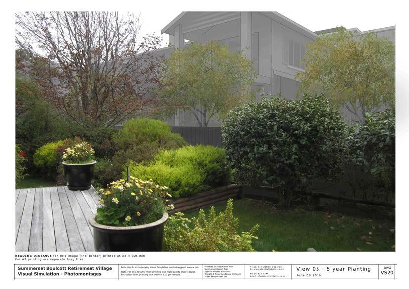
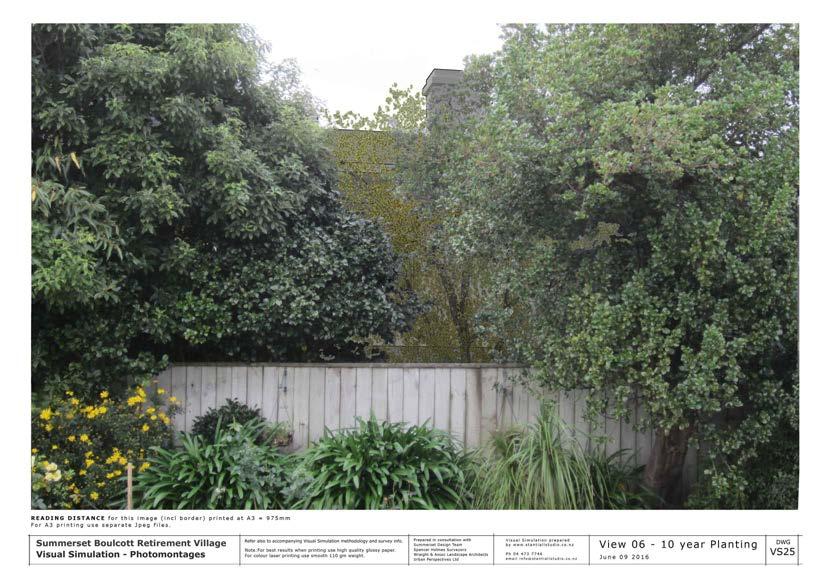
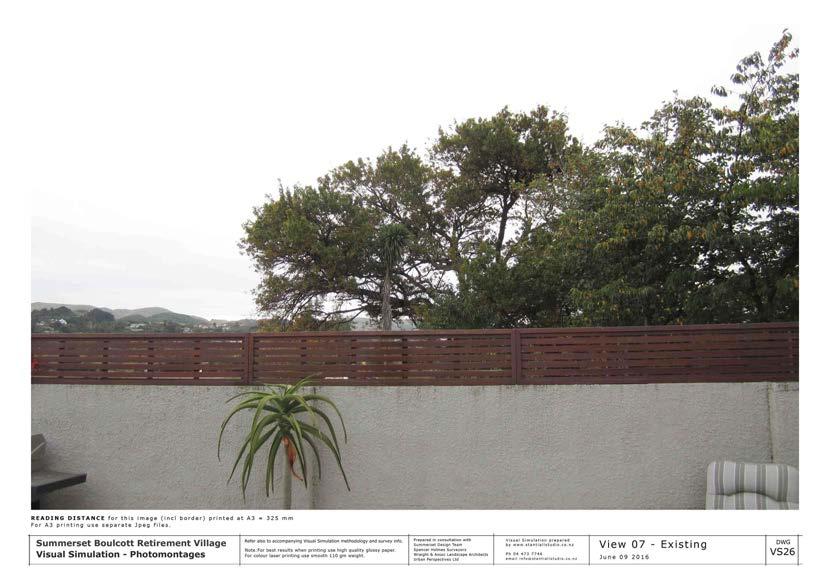
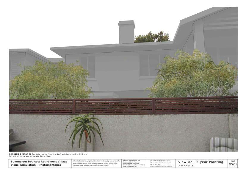
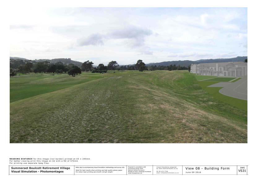
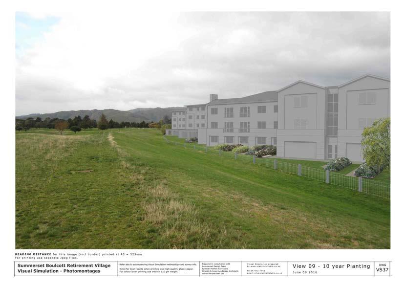
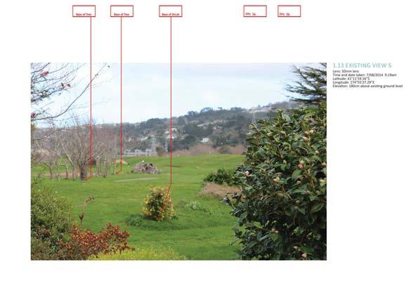
2 Visual Simulation methodology for Summerset Boulcott Retirement Village Photomontages 9 June 2016 pages 1 of 3 Introduction: Refer to photomontage collection Summerset Boulcott Retirement Village Visual Simulation. The 9 positions selected for visual simulations are shown in Dwg VSO1 - Index and view point plan 1. Intention The intention is to show in the selected views the visual effect that the proposed development will have. They are not real life views but rather simulations of a two dimensional view of the proposed activity from the given viewpoints. The degree of accuracy of +/-.05% of output size of image. The final imagery of built forms is not photorealistic but indicates bulk and location with indicative detail only. The survey data supplied is surveyed verified and was sufficient to provide accurate assessment of the buildings and landscaping visible. The steps outlined below describe the process and information used to develop the photomontages. 2. Process Methodology The process follows the guidelines of the NZILA Visual Simulation BPG 10.2 The simulations, created in the form of photomontages, utilise surveying architectural & landscaping information. It involved a series of processes to ensure as accurate as possible impressions of the proposed development within the photomontages. Final images are dependent an accuracy of information supplied. 3. Architectural Information (Summerset Design team & Aurecon) Information supplied included: A digital model of development. Site plan with FFL s, existing and finished site levels. 1
3 4. Landscape information (Wraight + Associates Landscape Architects and Summerset Design team) Master plan including: planting species and design. Direction re positioning of trees Information regarding scale of the tress. The simulations included versions showing tree specified 5 years = 4 m & 10 years =6m 5. Survey Information Information supplied by Spencer Holmes Surveyors. (Refer attached data) Survey PDF showing the viewpoint positions and R.Ls of the selected locations visible within the photographs used in the Visual Simulations. Surveyed site markers established on site (visible in the photo) Supplementary true scale markers measured and recorded photographically. 6. Site Photographs Site Photos were taken by Stantiall's Studio Ltd. for the development of the visual simulations. The 9 locations were survey verified by the surveyor and recorded on the survey plan. The camera used was a Canon Ixus 115 Digital with a 28 mm lens. Photos were taken between am and 2.30 pm, horizontally and on a tripod. 7. Model Development Building models supplied were imported into LIghtwave 3D modeling software. Indicative tree markers based on the landscape plan were placed into the model to provide a guide for proposed planting. These showed maturity to suit the various stages required. 8. Virtual Camera Placement The steps to place the 3D model into the photograph included: Using Lightwave 3D, the digital model is scaled 1:1 and placed into 3D space, then positioned in relation to the site plan and given a height relating to the RL on the site plan. Site markers are then modeled to match those in the photograph, using the height and RL information supplied by the surveyors, and placed into 3D space and positioned in relation to the site plan. 2
4 A virtual camera is then positioned to match the actual camera plot point on the site plan and given the camera height value based on survey information. Interpolation was used where required The photograph is brought into Lightwave 3D as a background image. The Markers within the 3d model are matched with those in the photograph. Further manual trigonometrical checks are carried out where required. 9. Rendering & compositions 1) A high quality image at the same resolution of the original photograph is then rendered out from Lightwave 3D. 2) Using Photoshop, the 3D model render was placed onto the original photograph 3) The render was then edited to fit into the surroundings, adding foreground elements from the original photograph and placed into their position in front of the 3D model. 4) Lighting and tonal adjustments were made to create a suitable bulk an location graphic appearance 5) Proposed tree planting added based on the indicative tree markers (Refer Model Development above). 10. Consultant Review To finalise and confirm the architectural and landscape detail visible the final content of the photomontages were reviewed by the design consultants. 11. Reading Distances (RD) By viewing the images from a particular distance, the actual scale of the view on site can be represented. This is termed the Reading Distance (RD) and is noted on the photo montages and is dependent on the size of image printed or projected. 3
5
6
7
8
9
10
11
12
13
14
15

16
17
18
19
20
21
22
23
24
25
26
27
28
29
30
31
32
33
34
35
36
37
38
39
40
41

42 140618c01 site survey.docx 11 th May 2016 Stantiall Studio PO Box Marion Square WELLINGTON 6141 Attention: Ian Stantiall Dear Ian, Boulcott Farm Heritage Golf Club, Lower Hutt We have completed the site survey at Boulcott Farm Heritage Golf Club and surrounding areas. Positions and levels for the points you requested have been surveyed and shown on our attached plans S SS1/A & SS2/A. The survey has been completed by GPS and total station observations. Coordinates are in terms of New Zealand Geodetic Datum 2000, Wellington Circuit. Levels are in terms of Mean Sea Level, Wellington Datum The source of coordinates and levels has been derived by GPS. Coordinates have been checked on to NZGD2000 geodetic survey control marks SP I DP & SPS II SO Levels have been checked on to Hutt City Council benchmark C.31. Each surveyed point shows a point number, description and reduced level. The points we have surveyed and shown are: - the points shown on your photographs Control Points pdf. - viewpoints 1 to 8 - points where a staff has been held for site photographs from viewpoints - extra points as requested. Please contact us if you have any questions or require anything further. Yours faithfully Spencer Holmes Limited Zane Oosten Senior Survey Technician Spencer Holmes Ltd Directors: Associates: Consultant: Jon Devine, Ian Leary, Philip McConchie, Hudson Moody Jo Cushen, Vaughan England, John McNaughton Peter Smith

43 NO A REVISION FIRST ISSUE BY DATE G208 BASE OF POST G209 BASE OF POST STKDG8 PPT 8A TRUNK T32 T33 TRUNK 8.44 JOINS PLAN S SS1 JOINS PLAN S SS2 VP8B VP G207 TOP CNR OF WALL T31 TOP OF LOG STKDG9 PPT 8B BASE OF POST G206 T17 TOP OF POLE PPT 1A G VP1 STKDVP1 T20 EAVE T19 RIDGE T16 TOP OF POLE BASE OF POLE T18 T8 EAVE LEVELS ARE IN TERMS OF MEAN SEA LEVEL WELLINGTON DATUM 1953 ORIGIN OF LEVELS : HCC BM C.31 REDUCED LEVEL = SOURCE: HCC RECORDS SpencerHolmes engineers - surveyors - planners Level 6-8 Willis Street PO Box 588 Wellington New Zealand Phone (04) Fax (04) admin@spencerholmes.co.nz CLIENT SUMMERSET VILLAGES T25 EAVE T24 EAVE GL T RIDGE T5 T6 TOP OF FENCE EAVE T VP3 STKDVP3B PROJECT BOULCOTT FARM HERITAGE GOLF CLUB DRAWING TITLE SITE SURVEY DESIGN CONSULTANT STKDVP2 VP EAVE T26 Copyright of this drawing is vested in Spencer Holmes Ltd. The Contractor shall verify all dimensions on site. CAUTION - The information shown on this plan has been prepared under specific instruction from the client and is intended solely for the clients use. The information is valid as at the date of survey. Spencer Holmes Limited will accept no liability for any consequence arising out of the use of this plan, or the information thereon whether in hard copy or electronic format by any other party for any purpose whatsoever. CAD FILE S SS1 - SS1 DRAWN AZO CHECKED SCALE 1 : 500 DRAWING NUMBER FB DATE S SS1 11/05/2016 AT REV A1 A

44 NO A REVISION FIRST ISSUE BY DATE T33 TRUNK 8.44 JOINS PLAN S SS1 JOINS PLAN S SS2 G27 PPT 4C PPT 4B STKD4B STKD4A PPT 4A 8.35 T87 EAVE T85 RIDGE T50 RIDGE EAVE T46 T45 TOP EDGE OF SKYLIGHT CNR OF SILL T G2032 T55 TOP OF FENCE PPT 5B STKD5B PPT 7B T47 G VP 5 SHRUB VP6 T47 G2101 PPT 7A T56 TOP OF FENCE JNT G26 VP T57 TOP OF FENCE JNT T58 TOP OF CONC. WALL EAVE T EAVE T VP4 G5 LEVELS ARE IN TERMS OF MEAN SEA LEVEL WELLINGTON DATUM 1953 ORIGIN OF LEVELS : HCC BM C.31 REDUCED LEVEL = SOURCE: HCC RECORDS SpencerHolmes engineers - surveyors - planners T8 EAVE RIDGE T5 T6 TOP OF FENCE EAVE T VP3 STKDVP3B Level 6-8 Willis Street PO Box 588 Wellington New Zealand Phone (04) Fax (04) admin@spencerholmes.co.nz CLIENT SUMMERSET VILLAGES PROJECT BOULCOTT FARM HERITAGE GOLF CLUB DRAWING TITLE SITE SURVEY DESIGN CONSULTANT Copyright of this drawing is vested in Spencer Holmes Ltd. The Contractor shall verify all dimensions on site. CAUTION - The information shown on this plan has been prepared under specific instruction from the client and is intended solely for the clients use. The information is valid as at the date of survey. Spencer Holmes Limited will accept no liability for any consequence arising out of the use of this plan, or the information thereon whether in hard copy or electronic format by any other party for any purpose whatsoever. CAD FILE S SS1 - SS2 DRAWN AZO CHECKED SCALE 1 : 500 DRAWING NUMBER FB DATE S SS2 11/05/2016 AT REV A1 A
45
46
47
48
49
50
51
Proposed Kumototo Site 10 Wellington
 Proposed Kumototo Site 10 Wellington Visualisation Simulation Methodology - Buildmedia Limited Contents 1.0 Introduction 2.0 Process Methodology Kumototo Site 10 Visual Simulation 3.0 Conclusion 1.0 Introduction
Before the Environment Court at Auckland ENV-2013-AKL
 Before the Environment Court at Auckland ENV-2013-AKL-000174 In the Matter of the Resource Management Act 1991 And In the Matter of Notice of Motion under Section 87G requesting the granting of resource
RAF DRAFT. Viewpoint 11: Taken from a road within Burlescombe, looking oking south-west towards the site.
 St. Mary s Church (Grade I listed) Viewpoint 11: Taken from a road within Burlescombe, looking oking south-west towards the site. RAF Approximate location of the site obscured by existing conifers FT Viewpoint
Appendix 8.2 Information to be Read in Conjunction with Visualisations
 Shepherds Rig Wind Farm EIA Report Appendix 8.2 Information to be Read in Conjunction with Visualisations Contents Contents i Introduction 1 Viewpoint Photography 1 Stitching of Panoramas and Post-Photographic
Architectural Design Process
 Architectural Design Process Custom Residential A. Schematic Design Phase Pre-Design Meeting Site Analysis Site Survey Conceptual Design & Project Scope Design Program Guideline Project Team Formation
Telecommunication Application Form
 Page 1 of 5 Fees Total Fee $1130.00 Processing Fee $330.00 *Advertising Deposit $800.00 *Where costs differ from the deposit, the balance will be charged or refunded to the applicant. Description of proposed
APPLICATION FOR CERTIFICATE OF APPROPRIATENESS IN THE HISTORIC DESIGN REVIEW DISTRICT
 209 South Main Street Marysville, Ohio 43040 Phone: (937) 645-7350 Fax: (937) 645-7351 www.marysvilleohio.org APPLICATION FOR CERTIFICATE OF APPROPRIATENESS IN THE HISTORIC DESIGN REVIEW DISTRICT *** IMPORTANT
Virtual Reality & Real-Time Simulation. Animation. 3D Stereoscopy
 tec3d Visualisation Virtual Reality & Real-Time Simulation tec3d Ltd produce 3D real-time or Virtual Reality simulations which allow the user to freely explore 3D virtual worlds through a first-person
SITE PLAN, SUBDIVISION & EXTERIOR DESIGN REVIEW PROCESS
 INCORPORATED VILLAGE OF ROCKVILLE CENTRE BUILDING DEPARTMENT SITE PLAN, SUBDIVISION & EXTERIOR DESIGN REVIEW PROCESS Presubmission - Prior to a formal submission, the applicant should meet in person with
CHICAGO LANDMARKS PERMIT APPLICATION AND PRE-PERMIT SUBMISSION REQUIREMENTS
 CHICAGO LANDMARKS PERMIT APPLICATION AND PRE-PERMIT SUBMISSION REQUIREMENTS The Commission on Chicago Landmarks reviews all permit applications for work to designated and proposed Chicago Landmarks and
DESIGN REVIEW BOARD APPLICATION EXTERIOR PLAN / LANDSCAPE PLAN
 209 S. Main Street Marysville, Ohio 43040 Phone: (937) 645-7350 Fax: (937) 645-7351 www.marysvilleohio.org DESIGN REVIEW BOARD APPLICATION EXTERIOR PLAN / LANDSCAPE PLAN *** IMPORTANT INFORMATION Please
Checklist for Minor Plan Modification
 Checklist for Minor Plan Modification All submittal information shall be provided to the Community Development Department. All submittal information shall be presented along with the Uniform Application,
East Anglia TWO & ONE North. Broom Covert, Sizewell Visualisations
 East Anglia TWO & ONE North Broom Covert, Sizewell Visualisations VIEWPOINT LOCATIONS Viewpoint 1: Sizewell Gap Road Viewpoint 2: Broom Covert Viewpoint 3: Sandy Lane Viewpoint 4: King George s Avenue
Architectural Review Application
 Architectural Review Application City of Beverly Hills Planning Division 455 N. Rexford Drive Beverly Hills, CA 90210 Tel. (310) 285 1141 Fax. (310) 858 5966 Architectural Review Overview: The Architectural
PARKING IMPROVEMENT AIRPORT CAMPUS AMENDED SITE PLAN APPROVAL DRAWINGS 113 KING STREET TOWN OF NORTH CASTLE, NEW YORK AIRPORT CAMPUS I-V LLC
 AMENDED SITE PLAN APPROVAL DRAWINGS PARKING IMPROVEMENT AIRPORT CAMPUS CLIENT: AIRPORT CAMPUS I-V LLC 113 KING STREET TOWN OF NORTH CASTLE, NEW YORK JMC DRAWINGS SITE PLANNER, CIVIL ENGINEER, SURVEYOR
SIGN PERMIT APPLICATION
 SIGN PERMIT APPLICATION City of Hawaiian Gardens Community Development Department 21815 Pioneer Boulevard, Hawaiian Gardens, CA 90716 Ph: (562) 420-2641 Fax: (562) 420-8521 www.hgcity.org Please complete
Owner / Architect Certification of Complete Documentation for the Additions and Remodels Conditional Approval Review
 Step 1: Request for Conditional Approval, page 1 of 5 Owner / Architect Certification of Complete Documentation for the Additions and Remodels Conditional Approval Review I,, the Property Owner, or Owner
I. REQUEST: The undersigned petition the Village of Matteson, Illinois to approve the application(s) submitted.
 submitted.") SITE PLAN BUILDING ELEVATION LANDSCAPE PLAN SIGNAGE PLAN APPLICATION FOR THE VILLAGE OF MATTESON I. REQUEST: The undersigned petition the Village of Matteson, Illinois to approve the application(s) submitted.
SITE PLAN BUILDING ELEVATION LANDSCAPE PLAN SIGNAGE PLAN APPLICATION FOR THE VILLAGE OF MATTESON I. REQUEST: The undersigned petition the Village of Matteson, Illinois to approve the application(s) submitted.
Section E NSPS MODEL STANDARDS FOR TOPOGRAPHIC SURVEYS Approved 3/12/02
 Section E NSPS MODEL STANDARDS FOR TOPOGRAPHIC SURVEYS Approved 3/12/02 1. INTRODUCTION This standard is written to provide the professional surveyor (Surveyor) and the client with a guideline for producing
VISUAL RESOURCE EVALUATION PROPOSED ATTACHED WIRELESS TELECOMMUNICATIONS INSTALLATION
 VISUAL RESOURCE EVALUATION PROPOSED ATTACHED WIRELESS TELECOMMUNICATIONS INSTALLATION 965 ANDERSON HILL ROAD RYE BROOK WESTCHESTER COUNTY NEW YORK Submitted by: 175 Calkins Road Rochester, NY 14623 Prepared
HYDROGRAPHIC SURVEY STANDARDS AND DELIVERABLES
 TABLE OF CONTENTS 1. HYDROGRAPHIC SURVEY METHODOLOGY... 3 2. HYDROGRAPHIC SURVEY REFERENCE STANDARDS... 3 3. HYDROGRAPHIC SURVEY CRITERIA... 3 3.1 HYDROGRAPHIC SURVEYS OVER NON GAZETTED NAVIGABLE WATERS*:...
APPENDIX D: DRAWING SUBMISSION STANDARDS
 1.0 FIRST SUBMISSION CONCEPTUAL DESIGN Once the Developer has obtained approval for a Development Application where Park or Open Space improvements are required, a detailed Park or Open Space submission
Option 1. Design Options are diverse e.g. new route alignments covering a wide area. Option 2. Design Options are restricted
 MINIMUM STANDARD Z/16 SURVEY SPECIFICATIONS 1. GENERAL This specification sets out the Consultant s requirements for topographical survey (ground and aerial) for the Detailed Business Case (DBC) and Pre-Implementation
APPLICATION DESIGN REVIEW Please Print or Type
 www.srcity.org ZONING ADMINISTRATOR (ZA) APPLICATION DESIGN REVIEW Please Print or Type DESIGN REVIEW BOARD File # Related Files: LOCATION OF PROJECT (ADDRESS) ASSESSOR S PARCEL NUMBER(S) EXISTING ZONING
GEORGE M. JANES & ASSOCIATES. September 4, Ted Fink Greenplan 302 Pells Rd. Rhinebeck, NY 12572
 GEORGE M. JANES & ASSOCIATES PLANNING with TECHNOLOGY 250 EAST 87TH STREET NEW YORK, NY 10128 www.georgejanes.com September 4, 2008 Ted Fink Greenplan 302 Pells Rd. Rhinebeck, NY 12572 T: 917.612.7478
Guidelines for Laying Targets for Ground Control Points
 Guidelines for Laying Targets for Ground Control Points Overview of target requirements: Three to four unambiguous ground survey targets, recognizable in the satellite photo, are requested. The survey
City of Whitefish 418 E 2 nd St PO Box 158 Whitefish, MT Phone: Fax:
 City of Whitefish 418 E 2 nd St PO Box 158 Whitefish, MT 59937 406-863-2460 Fax: 406-863-2419 File #: : Intake Staff: Check #: Amount: ARCHITECTURAL REVIEW Multifamily, Townhouse, Duplex Complete: FEE
SITE PLAN Application Packet (Required For All Non-Residential Development Projects)
") SITE PLAN Application Packet (Required For All Non-Residential Development Projects) Community Development Department 90 North Main Street, Tooele, UT 84074 (435) 843-2130 Fax (435) 843-2139 Dear Applicant,
SITE PLAN Application Packet (Required For All Non-Residential Development Projects) Community Development Department 90 North Main Street, Tooele, UT 84074 (435) 843-2130 Fax (435) 843-2139 Dear Applicant,
IAN HUMBY TEACHING. List of Hand-Outs. Levelling
 IAN HUMBY TEACHING List of Hand-Outs Levelling 6-1 Equipment List (Levelling) 11-1 to 11-3 Introduction to Levelling 11-4 Levelling Terminology 12-1 to 12-2 Measuring Height Change by Basic Methods 13-1
looking west looking east A0.6 Proposed Development Model Shots 1327 Marine Drive West Vancouver revision date fax (604) phone (604)
 phone (604)") THIS DRAWING IS THE EXCLUSIVE PROPERTY OF THE ARCHITECTS AND CAN BE REPRODUCED ONLY WITH THE PERMISSION OF THE ARCHITECTS, IN WHICH CASE THE REPRODUCTION MUST BEAR THEIR NAME AS ARCHITECTS. fax (604) 926-1059
THIS DRAWING IS THE EXCLUSIVE PROPERTY OF THE ARCHITECTS AND CAN BE REPRODUCED ONLY WITH THE PERMISSION OF THE ARCHITECTS, IN WHICH CASE THE REPRODUCTION MUST BEAR THEIR NAME AS ARCHITECTS. fax (604) 926-1059
VISUALISATION STANDARDS
 VISUALISATION STANDARDS INTRODUCTION These standards have been produced to enable the Council to verify that photomontages submitted in support of planning applications and contained with Environmental
PICTURING THE PAST AT MILLS MANSION GREENHOUSE COMPLEX
 PICTURING THE PAST AT MILLS MANSION GREENHOUSE COMPLEX Mary Gregorie Burns The title "Picturing the Past" derives from comparing a photograph of the present-day Mills Mansion landscape to a 1920s photograph
Zone 7 (W1) Visualisations
 Visualisations") Zone 7 (W1) Visualisations East Anglia TWO & ONE NORTH Developer: Scottish Power Renewables Date: June 2018 This page is intentionally blank VIEWPOINT LOCATIONS 5 10 Viewpoint 1: Grove Road Viewpoint 2:
Zone 7 (W1) Visualisations East Anglia TWO & ONE NORTH Developer: Scottish Power Renewables Date: June 2018 This page is intentionally blank VIEWPOINT LOCATIONS 5 10 Viewpoint 1: Grove Road Viewpoint 2:
Survey Requirements. Design Guidelines and Standards. June Office of the University Architect
 Design Guidelines and Standards Survey Requirements June 2004 Office of the University Architect Construction Management P.O. Box 210181 Cincinnati, Ohio 45221-0181 Table of Contents Survey Requirements
City of Whitefish Planning & Building Department PO Box E 2 nd Street Whitefish, MT Phone: Fax:
 City of Whitefish Planning & Building Department PO Box 158 418 E 2 nd Street Whitefish, MT 59937 Phone: 406-863-2410 Fax: 406-863-2409 ARCHITECTURAL REVIEW Multifamily, Townhouse, Duplex FEE ATTACHED
APPLICATION FOR SITE PLAN CONTROL
 APPLICATION FOR SITE PLAN CONTROL Section 41 of the Planning Act, RSO 1990, as amended A Pre-Application Consultation with City staff is encouraged prior to submission of this application. This application
ARCHITECTURAL REVIEW COMMITTEE TOWN APARTMENT CONSTRUCTION SUBMITTAL FORM AND APPLICATION
 For Office Use Only Date Received: Approved: ARC Non-Refundable Fees ARC Refundable Deposit Pd: For Office Use Only Plat Name: Lot # Street Address: New Construction Alteration Preliminary Final ARCHITECTURAL
Last Name: First Name: M.I:
 ARCHITECTURE DESIGN REVIEW BOARD APPLICATION OFFICE USE ONLY APPLICATION # Permit # Fee Collected $ 1. Filing Status Initial Submission Amendment Withdrawal 2. Cost of Construction (Industry Standards)
February Prepared for
 Energy from Waste Combined Heat and Power Facility, Tree Inspection for the Potential to Support Roosting Bats February 2011 Prepared for Revision Schedule Tree Inspection for the Potential to Support
Mailing Address: Fax number: City: State: Zip: Property Owner: City: State: Zip: City: State: Zip:
 / Department of Community Development ARCHITECTURAL REVIEW APPLICATION 73-510 Fred Waring Drive Palm Desert California 92260 (760) 346-0611 Fax (760) 776-6417 Applicant: Telephone: Mailing Address: Fax
City of Miami Planning and Zoning Department UDRB SUBMITTAL CHECK LIST
 City of Miami Planning and Zoning Department UDRB SUBMITTAL CHECK LIST One 11 x 17 signed and sealed original set and 11 copies must be submitted to the Planning and Zoning Department inclusive of all
For Office Use: Filing Date: Case Number: Zoning District: LIST ALL ADDRESSES INVOLVED IN YOUR PROJECT:
 City of Syracuse Zoning Administration Application for CHANGE OF OCCUPANCY Review by the Planning Commission City Hall Commons * Room 101 * 201 E. Washington Street * Syracuse, NY 13202-1426 * 315-448-8640
1. Land survey Work. 2. Civil and Structural engineering services.
 SECTION 01050 FIELD ENGINEERING PART 1 - GENERAL 1.01 RELATED DOCUMENTS A. Drawings and general provisions of the Contract, including General and Supplementary Conditions and other Division-1 Specification
Section 4: Ontario Realty Corporation CAD Standards and Guidelines
 Section 4: Ontario Realty Corporation CAD Standards and Guidelines Ontario Realty Corporation 11 th Floor, Ferguson Block 77 Wellesley Street West Queen s Park Toronto, ON, M7A 2G3 August 10, 2007 Version
Ball State University Department of Architecture Spring 2017 Grondzik
 ASSIGNMENT THREE Delightful Daylighting DUE: various dates POINTS: 7 of 45 Objectives: The intent of this assignment is to provide hands-on experience with the use of daylighting models as a design and
CLIPPER ESTATES HOMEOWNER S ASSOCIATION DESIGN GUIDELINES
 CLIPPER ESTATES HOMEOWNER S ASSOCIATION DESIGN GUIDELINES CLIPPER ESTATES DESIGN GUIDELINES FEBRUARY 1995 INTRODUCTION 1 THE DESIGN REVIEW PROCESS 1 Design Review Approval 2 Architectural Submission 2
Don Hillock Drive ONE UNIT REMAINING. Aurora, ON LARGE INDUSTRIAL FACILITY FOR LEASE IN AURORA FOR LEASE > INDUSTRIAL FACILITY
 FOR LEASE > INDUSTRIAL FACILITY 250 Don Hillock Drive Aurora, ON ONE UNIT REMAINING LARGE INDUSTRIAL FACILITY FOR LEASE IN AURORA Ideally situated right next to the Highway 404/Wellington Street on ramp,
Suveying Lectures for CE 498
 Suveying Lectures for CE 498 SURVEYING CLASSIFICATIONS Surveying work can be classified as follows: 1- Preliminary Surveying In this surveying the detailed data are collected by determining its locations
CLIENT GUIDE TO MEASURED BUILDING SURVEYS
 CLIENT GUIDE TO MEASURED BUILDING SURVEYS ISSUE 4 FEBRUARY 2016 TSA The Survey Association s Client Guides are primarily aimed at other professionals such as engineers, architects, planners and clients
BIM. e Submission Guideline Structural. Annex 1a. Recommended Process Revit 2010
 BIM e Submission Guideline Structural Annex 1a Recommended Process Revit 2010 Building and Construction Authority 5 Maxwell Road #16-00 Tower Block MND Complex Singapore 069110 www.bca.gov.sg Revision
Architectural Sketches and Perspectives
 Architectural Sketches and Perspectives Neil & Irene Coleman 97 Hadfield Street Beach Haven Auckland New Zealand Phone: +64 9 483 5018 Fax: +64 9 483 3018 E-Mail: neil@asap.net.nz Web: www.asap.net.nz
Oakland County Michigan Register of Deeds Plat Engineering, GIS, & Remonumentation Dept. Ph: (248) Fax (248)
 Fax (248)") Oakland County Michigan Register of Deeds Plat Engineering, GIS, & Remonumentation Dept. Ph: (248)-858-1447 Fax (248)-858-7466 Requirements Needed for Final Condominium Approval General Requirements. 1
Oakland County Michigan Register of Deeds Plat Engineering, GIS, & Remonumentation Dept. Ph: (248)-858-1447 Fax (248)-858-7466 Requirements Needed for Final Condominium Approval General Requirements. 1
2D Drawings Levels of Detail Specification
 2D Drawings Levels of Detail Specification March 2018 2D Measured Building Survey Level of detail Level of detail should be chosen based on the intention that the final drawings will be used for. It should
Question bank. Unit 1: Introduction
 Question bank Unit 1: Introduction 1. Define surveying. 2. State the objects of surveying 3. State and explain the principle of surveying 4. State and explain the classification of surveying 5. Differentiate
Public Call to Artists for Expressions of Interest Newton Recreation Centre Glass Curtain Wall Design for glass frit application
 Public Call to Artists for Expressions of Interest Newton Recreation Centre Glass Curtain Wall Design for glass frit application Goal: an image and metaphor that represents: Weaving Communities Together
SURVEYING FOR ENGINEERING PROJECTS
 NEW JERSEY SOCIETY OF PROFESSIONAL LAND SURVEYORS presents A SEMINAR BY BILL BEARDSLEE, P.L.S., P.E., P.P. SURVEYING FOR ENGINEERING PROJECTS Name Employer Location Total Employees Employees in Surveying
Specifications for Post-Earthquake Precise Levelling and GNSS Survey. Version 1.0 National Geodetic Office
 Specifications for Post-Earthquake Precise Levelling and GNSS Survey Version 1.0 National Geodetic Office 24 November 2010 Specification for Post-Earthquake Precise Levelling and GNSS Survey Page 1 of
Simonson Design Lab, Inc. Design Agreement
 2016-2017 Simonson Design Lab, Inc. The Terms Consultation Time: The time you spend working directly with a designer either with or without your builder. We highly recommend you use the A Guide to Designing
COPYRIGHTED MATERIAL. Contours and Form DEFINITION
 1 DEFINITION A clear understanding of what a contour represents is fundamental to the grading process. Technically defined, a contour is an imaginary line that connects all points of equal elevation above
APPLICATION FOR PLANNED UNIT DEVELOPMENT (PUD) DEVELOPMENT PLAN
 DEVELOPMENT PLAN") 209 S. Main Street Marysville, Ohio 43040 Phone: (937) 645-7350 Fax: (937) 645-7351 www.marysvilleohio.org APPLICATION FOR PLANNED UNIT DEVELOPMENT (PUD) DEVELOPMENT PLAN *** IMPORTANT INFORMATION ~ Please
209 S. Main Street Marysville, Ohio 43040 Phone: (937) 645-7350 Fax: (937) 645-7351 www.marysvilleohio.org APPLICATION FOR PLANNED UNIT DEVELOPMENT (PUD) DEVELOPMENT PLAN *** IMPORTANT INFORMATION ~ Please
Town of Holly Springs Sign Installation Packet
 Town of Holly Springs Sign Installation Packet Department of Planning & Zoning 128 S. Main Street P.O. Box 8 Holly Springs, NC 27540 (919) 557-3908 HSPlanning@hollyspringsnc.us GENERAL INFORMATION: If
SUBMITTAL REQUIREMENTS FOR USE PROCESS III OR PROCESS IV
 COMMUNITY DEVELOPMENT DEPARTMENT 33325 8 th Avenue South Federal Way WA 98003 253-835-2607; Fax 253-835-2609 www.cityoffederalway.com SUBMITTAL REQUIREMENTS FOR USE PROCESS III OR PROCESS IV USE PROCESS
Architectural Review Application New Application Processing Improvements
 Architectural Review Application New Application Processing Improvements Dear Applicant, Fees Reduced. Application fees were reduced approximately 20% from the 2010 2011 fiscal year. The Planning Division
ARCHITECTURAL REVIEW COMMITTEE HOMESITE CONSTRUCTION SUBMITTAL FORM AND APPLICATION
 For Office Use Only Date Received: Approved: ARC Non-Refundable Fees: ARC Refundable Deposit Pd: For Office Use Only Plat Name: Lot # Street Address: New Construction Alteration Preliminary Final ARCHITECTURAL
TECHNICAL SPECIFICATION
 TECHNICAL SPECIFICATION IEC TS 61400-14 First edition 2005-03 Wind turbines Part 14: Declaration of apparent sound power level and tonality values IEC 2005 Copyright - all rights reserved No part of this
Determining Crash Data Using Camera Matching Photogrammetric Technique
 SAE TECHNICAL PAPER SERIES 2001-01-3313 Determining Crash Data Using Camera Matching Photogrammetric Technique Stephen Fenton, William Neale, Nathan Rose and Christopher Hughes Knott Laboratory, Inc. Reprinted
Applying for a Site Development Review
 Guide What is it? Applying for a Who approves it? ensures that new buildings or land uses are compatible with their sites and with the surrounding environment, other development, and traffic circulation.
INTENT An Administrative Site Plan is required for the following situations, excluding single-family detached development:
 SECTION 13-400 ADMINISTRATIVE SITE PLAN 13-401 INTENT An Administrative Site Plan is required for the following situations, excluding single-family detached development: A. All development on vacant land
Environmental Design. Floor Plan. Planometric Drawing. Target Audience. Media. Materials
 Environmental Design The design of large-scale aspects of the environment by means of architecture, interior design, way-finding, landscape architecture, etc. Floor Plan A scale diagram of the arrangement
Perspective. Basic Perspective For Drawing
 Perspective Basic Perspective For Drawing Perspective is one of the most important tools in drawing a 3-dimensional scene or object on a 2-dimensional surface. Types of Linear perspective: Single- (or
INDIGO LAKES HOA ARCHITECTURAL REVIEW COMMITTEE REQUEST FOR MODIFICATION
 INDIGO LAKES HOA ARCHITECTURAL REVIEW COMMITTEE REQUEST FOR MODIFICATION I/We hereby request approval by the Architectural Review Committee for the modification shown below of Lot #: Street Address: Phone
2013 Assessment Report. Design and Visual Communication (DVC) Level 2
 Level 2") National Certificate of Educational Achievement 2013 Assessment Report Design and Visual Communication (DVC) Level 2 91337 Use visual communication techniques to generate design ideas. 91338 Produce working
National Certificate of Educational Achievement 2013 Assessment Report Design and Visual Communication (DVC) Level 2 91337 Use visual communication techniques to generate design ideas. 91338 Produce working
Office use only: Application Date: UT No.: EA No.: Property Address: ENGINEERING APPROVAL - SUBDIVISION OR STAND-ALONE ENGINEERING WORK
 Office use only: Application Date: UT No.: EA No.: Development Title: Property Address: Application for ENGINEERING APPROVAL - SUBDIVISION OR STAND-ALONE ENGINEERING WORK The following to be completed
Home Improvement Application. Type of Improvement
 1 Home Improvement Application Note: This application needs to be submitted 45 days before any planned activity. Homeowner Name: Property : : Email: Proposed Start Date: Proposed Completion Date Type of
Bulletin. Loss Control. Land Surveyors. Towards Achieving Measurement Redundancy* Professional Liability Insurance. Background
 Bulletin No. 13 February 2008 Revised November 2014 ENCON Group Inc. Telephone 613-786-2000 Facsimile 613-786-2001 Toll Free 800-267-6684 www.encon.ca Loss Control Bulletin Land Surveyors Professional
Level 1 Imaging software (DIS )
") Level 1 Imaging software (DIS 7574-121) ITQ (QCF) Assignment guide for Candidates Assignment A (This assignment can alternatively be used to demonstrate completion of 7574-120 Design software) www.cityandguilds.com
Level 1 Imaging software (DIS 7574-121) ITQ (QCF) Assignment guide for Candidates Assignment A (This assignment can alternatively be used to demonstrate completion of 7574-120 Design software) www.cityandguilds.com
Agenda 1 Introduction 2 Navisworks Overview
 Agenda 1 Introduction 2 Navisworks Overview BIM for Contractors: Autodesk Navisworks from Design to Construction to Facilities Management David Epps Manager Building Information Modeling Holder Construction
HABITATS REGULATIONS ASSESSMENT St. Anne s on the Sea Neighbourhood Plan Addendum to Screening Opinion OCTOBER 2016
 HABITATS REGULATIONS ASSESSMENT St. Anne s on the Sea Neighbourhood Plan Addendum to Screening Opinion OCTOBER 2016 CONTACTS JO WEAVER Senior Ecologist dd +44 (0)1453 423124 m +44 (0)7809 549186 e jo.weaver@arcadis.com
Modifications Committee Guidelines
 Modifications Committee Guidelines Changed Jul 13, 10 Changed Apr 12, 11 1 WYNLAKES MODIFICATIONS COMMITTEE Modifications Review Guidelines I. Purpose II. III. IV. Submittal Process A. One step minor work
SITE STATISTICS SQ.FT [ SQ.M.]
![SITE STATISTICS SQ.FT [ SQ.M.]](/thumbs/89/100568242.jpg "SITE STATISTICS SQ.FT [ SQ.M.]") SITE PLAN :00 No. 66 ADJACENT STOREY DWELLING LOT AREA GFA SITE STATISTICS 870.77 SQ.FT [777.67 SQ.M.] N 8 00'" E OVERHEAD WIRE '-7 " [760] EXISTING PRIVATE TREE TO BE REMOVED '-" [680] 9'-7" [90] 9'-7
SITE PLAN :00 No. 66 ADJACENT STOREY DWELLING LOT AREA GFA SITE STATISTICS 870.77 SQ.FT [777.67 SQ.M.] N 8 00'" E OVERHEAD WIRE '-7 " [760] EXISTING PRIVATE TREE TO BE REMOVED '-" [680] 9'-7" [90] 9'-7
ARCHITECT VECTORWORKS EIGHTH EDITION TUTORIAL MANUAL BY JONATHAN PICKUP
 CH EIGHTH EDITION TUTORIAL MANUAL BY JONATHAN PICKUP A M TO R I A L T TU EC IT UA L AR ARCHITECT N HTH EDITION EIG / / / / / / / / / / / / / / / / / / / / / / / / / / / / / / / / / / / / / / / / / / /
Date Requested, 200_ Work Order No. Funding source Name of project Project limits: Purpose of the project
 Bureau of Engineering SURVEY DIVISION REQUEST FOR TOPOGRAPHIC SURVEY Date Requested, 200_ Work Order No. Funding source Name of project Project limits: Purpose of the project Caltrans involvement (must
DatuGram 2D. User Guide. Version 2.0 August Datumate Geomatics Expert Systems
 DatuGram 2D User Guide Version 2.0 August 2013 Datumate Geomatics Expert Systems Using DatuGram, land surveying is made easier, faster and with excellent geodetic accuracy. For more information please
Manually verifiable area calculations; and BC Land Surveyor certified area calculations (typically practical only for large development proposals).
.") City of Vancouver Planning - By-law Administration Bulletins Community Services, 453 W. 12th Ave Vancouver, BC V5Y 1V4 F 604.873.7344 fax 604.873.7060 planning@city.vancouver.bc.ca AREA CALCULATION AND
City of Vancouver Planning - By-law Administration Bulletins Community Services, 453 W. 12th Ave Vancouver, BC V5Y 1V4 F 604.873.7344 fax 604.873.7060 planning@city.vancouver.bc.ca AREA CALCULATION AND
This document is a preview generated by EVS
 TECHNICAL SPECIFICATION IEC TS 61400-14 First edition 2005-03 Wind turbines Part 14: Declaration of apparent sound power level and tonality values Reference number IEC/TS 61400-14:2005(E) Publication numbering
SECTION 4 DESIGN SURVEYS
 SECTION 4 DESIGN SURVEYS Table of Contents Page No 4.1 AERIAL PHOTOGRAPHY CRITERIA...1 4.1.1 SCALE OF NEGATIVES... 1 4.1.2 PHOTOGRAMMETRIC GROUND CONTROL... 1 4.1.3 LOW ALTITUDE MAPPING & PHOTOGRAMMETRY
LESSON 1: UNDERSTANDING CONSTRUCTION DRAWINGS
 LESSON 1: UNDERSTANDING CONSTRUCTION DRAWINGS INTRODUCTION In this lesson, you ll learn about the different types of drawings used in the construction industry, and how to read floor plans, section drawings,
R 1 Design Review Application
 City of Beverly Hills Planning Division 455 N. Rexford Drive Beverly Hills, CA 90210 Tel. (310) 285 1141 Fax. (310) 858 5966 R 1 Design Review Application Design Review Overview Beverly Hills residential
SURVEYORS BOARD OF QUEENSLAND. RTK GNSS for Cadastral Surveys. Guideline
 SURVEYORS BOARD OF QUEENSLAND RTK GNSS for Cadastral Surveys Guideline 30 November 2012 RTK GNSS for Cadastral Surveys General The Surveyors Board of Queensland has recently become aware of some issues
A NEW GEOCENTRIC DATUM FOR NEW ZEALAND
 A NEW GEOCENTRIC DATUM FOR NEW ZEALAND Don Grant Graeme Blick Office of Surveyor-General Land Information New Zealand PO Box 5501 Wellington New Zealand Phone 04 4600100 Fax 04 4722244 dgrant@linz.govt.nz
Checklist for Tentative Subdivision Map
 Checklist for Tentative Subdivision Map All submittal information shall be provided to the Community Development Department. All submittal information shall be presented along with the Uniform Application,
CONCEPT REVIEW GUIDELINES
 Department of Planning & Community Development @ Jefferson Station 1526 E. Forrest Avenue Suite 100 East Point, GA 30344 404.270.7212 (Phone) 404.765.2784 (Fax) www.eastpointcity.org CONCEPT REVIEW GUIDELINES
This Call for Qualifications does not require the preparation of a design proposal.
 EDMS# 211137 I. Introduction This Call for Qualifications invites professional artists, or artist team, to participate in a two-stage selection process to develop an original, public art work for Port
Architectural Review Committee (ARC) Amended Guidelines for All ARC Applications
 Amended Guidelines for All ARC Applications") Heritage Palms Golf & Country Club Architectural Review Committee (ARC) Amended Guidelines for All ARC Applications (Approved by the HPGCC Board of Directors, Resolution #190, on May 19, 2014) Introduction
Heritage Palms Golf & Country Club Architectural Review Committee (ARC) Amended Guidelines for All ARC Applications (Approved by the HPGCC Board of Directors, Resolution #190, on May 19, 2014) Introduction
GEORGE M. JANES & ASSOCIATES. July 12, Sabrina Charney-Hull Planning Director Town of New Castle 200 South Greeley Avenue Chappaqua, NY 10514
 GEORGE M. JANES & ASSOCIATES PLANNING with TECHNOLOGY 250 EAST 87TH STREET NEW YORK, NY 10128 www.georgejanes.com T: 646.652.6498 F: 801.457.7154 E: george@georgejanes.com July 12, 2012 Sabrina Charney-Hull
Excavation and Watching Brief
 12a Friars Entry Oxford Archaeological Excavation and Watching Brief Report January 2013 Client: OISE Holdings Ltd Issue No: 1 OA Job No: 5515 NGR: SP 5114 0643 Excavation and Watching Brief 12A
CITY OF OLIVETTE SITE PLAN AND COMMUNITY DESIGN REVIEW INFORMATION PACKET
 CITY OF OLIVETTE SITE PLAN AND COMMUNITY DESIGN REVIEW INFORMATION PACKET THE FOLLOWING PACKET CONTAINS: PETITION FOR NONRESIDENTIAL DEVELOPMENT SITE PLAN AND COMMUNITY DESIGN REVIEW SCHEDULE OF DATES
ARB ACTION MEMO. Mr. Wardell called the meeting to order at 1:00 p.m. and established a quorum.
 Date: August 6, 2018 Time: 1:00 PM Meeting Room: Room 241, Second Floor Members: Frank Stoner: Present Frank Hancock: Present Bruce Wardell, Chair: Present Stan Binsted, Vice Chair: Present Dade Van Der
City of Del Mar Planning Department Submittal Checklist ADR ADMINISTRATIVE DESIGN REVIEW PERMIT
 City of Del Mar Planning Department Submittal Checklist ADR ADMINISTRATIVE DESIGN REVIEW PERMIT ADR - Project Address: Related Permits/Actions: Owner (Last Name): The following list of documents is exhaustive
ELECTRONIC DRAFTING GUIDELINES
 ELECTRONIC DRAFTING GUIDELINES Edition No. 6 Updated November 2016 TABLE OF CONTENTS Section Title Page 1 Definitions 3 2 Drawing Format 3 2.1 Standards & Guidelines 3 2.2 Survey Plans 4 2.3 Underground