2012 Annual Report. Prepared by: Tim Breault, PFLCC Coordinator. 1 P a g e
|
|
|
- Cordelia Jennings
- 5 years ago
- Views:
Transcription

1 2012 Annual Report Prepared by: Tim Breault, PFLCC Coordinator 1 P a g e

2 2 P a g e Peninsular Florida Geography
3 3 P a g e
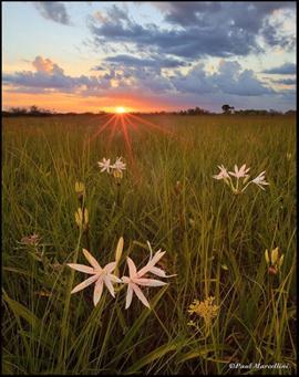
4 Description The Peninsular Florida Landscape Conservation Cooperative (PFLCC) is in a transitional zone where the pine and bottomland hardwood elements of the Coastal Plain begin to merge with the tropical elements of south Florida. The peninsula of Florida supports unique habitats including the scrub habitats of the Lake Wales Ridge, the Big Cypress Swamp, the coral reefs and tropical hardwood hammocks of the Florida Keys, mangroves, interior dry prairie, cypress domes and the Everglades. Florida has abundant surface water in lakes, rivers, streams, marshes and springs. The underlying karst geology supports more first magnitude springs than any other state (33). Florida has 10,000 miles of rivers and streams and 7,800 lakes. The Everglades and Big Cypress Swamp cover almost 25% of the peninsula. The peninsula of Florida is also home to an endemic subspecies of black bass, the Florida bass, which is much prized by anglers and, species like Alligator gar, American shad and Gulf sturgeon. The central Florida Lake Wales Ridge is a center of plant and animal endemism and an international biodiversity hotspot that includes all of the world s Florida scrub-jays. Also found are sand skinks, numerous threatened and endangered scrub plant species and some of the largest meta-populations of gopher tortoises in Florida, This landscape also includes some of the highest elevations in the peninsula which were formed from ancient dunes during glacial epochs that involved global warming. 4 P a g e
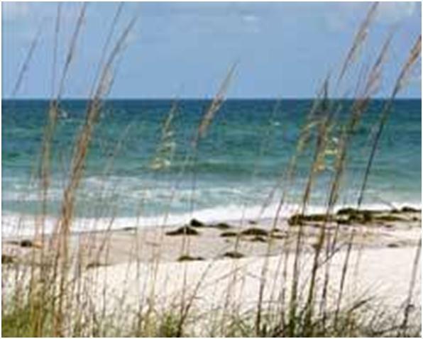
5 The peninsula of Florida is literally a sand spit surrounded on all sides by ocean. The peninsula is abutted on the east and south by the Atlantic and Caribbean; respectively, and on the west by the Gulf of Mexico. Coastal habitats in Florida range from barrier islands to sandy beaches and dunes, to coastal marsh, mud flats, and mangroves, to sea grass flats, oyster bars and to near shore coral reefs. These near shore and inter-tidal habitats are very important for wildlife including birds, turtles, juvenile saltwater fish, mollusks and invertebrates. Breeding colonies of Wood stork, Glossy ibis, and 19 other herons and egrets occur in freshwater wetlands. Snail kite, Short-tailed hawk, and Limpkin also breed in the interior wetlands. One of the greatest wading-bird nesting concentrations in the world is found in the Everglades. White-crowned pigeons and the American crocodile inhabit the Florida Keys along with other endangered species including Key deer, Key Largo wood rat, Miami Blue butterfly and Keys marsh rabbit. The only breeding site for Brown noddy, Sooty tern, and Magnificent frigate bird in the US is on the Dry Tortugas which are at the extreme end of the Florida Keys archipelago. Wintering waterfowl abound in inland waters, including large numbers of Scaup, Ring-necked duck, and to a lesser extent Blueand Green-winged teal. Coastal bays support Canvasbacks, Buffleheads and Redhead ducks in small to large aggregations where submerged grass flats occur. The peninsula of Florida is home to endemic subspecies of the Florida mottled duck, Florida Wood duck, and Fulvous whistling duck. 5 P a g e

6 Many other species of reptiles, amphibians and mammals occur, including iconic species like Florida panther, American alligator, Florida black bear and Florida manatee The transition from temperate to tropical climatic zones contributes to the high diversity of fish and wildlife including over 400 species of nonnative animals that have been introduced to the native landscape. Most of these introduced species are fish and reptiles and approximately 10% are considered invasive. Many more are invasive plant species that are considered injurious or invasive or both. Five species of marine turtles, including loggerhead, green, leatherback, Kemp s Ridley and hawksbill routinely nest on the sand beaches of Florida, which also provide nesting habitat and important foraging areas for shorebirds. Most of the remaining nesting Snowy Plovers in the southeast occur along Florida s Gulf Coast. Extraordinary numbers of wintering and transitory shorebirds also use the region particularly; Short-billed dowitchers, Piping plover, Dunlin and Red knot. These important near shore habitats support important continental breeding populations of Brown pelicans, Black skimmers, and various terns. 6 P a g e

7 The Partnership The PFLCC partnership is directed through a Steering Committee currently comprised of 22 members representing diverse conservation interests. The PFLCC Steering Committee has representation from: US Fish & Wildlife Service US Geological Survey National Park Service National Oceanic and Atmospheric Administration Department of Defense USDA/Forest Service 7 P a g e

8 Natural Resources Conservation Service Florida Fish & Wildlife Conservation Commission Florida Department of Agriculture and Consumer Services Florida Department of Transportation Southwest Florida Water Management District The Nature Conservancy Florida Wildlife Federation Florida Forestry Association Florida Farm Bureau Federation Wildlands Conservation Plum Creek Breedlove, Dennis & Associates, Inc. (Florida Land Council) Ken Passarella, and Associates, Inc. Family Lands Remembered, LLC Florida State University, Florida Natural Areas Inventory University of Florida, Center for Landscape Conservation Perhaps most noticeable is the representation from private landowner interests. The current Steering Committee Chair is Tom H. Logan, Vice-President of Breedlove, Dennis & Associates, Inc., representing large landowners in conservation efforts. Thomas Eason is Vice-chair and is affiliated with the Florida Fish and Wildlife Conservation Commission. 8 P a g e
9 Vision Our conservation cooperative is a valued resource for conservation design and delivery that supports a Florida landscape comprised of functional and interconnected ecosystems, valued by citizens, that contribute to regional and national conservation landscape connectivity. Mission The mission of the PFLCC is to foster landscape scale conservation to sustain natural and cultural resources for future generations. Guiding Principles The primary focus for achieving participation across all landowner, organizational and agency groups shall be through incentive-based methods that provide and maintain social, economic and ecological value of natural systems for future generations. 9 P a g e
10 Habitat conservation is a means to attain our ultimate goal the conservation of fish and wildlife populations and ecological functions that sustain them for the benefit of people. Defining measurable population objectives is a key component of landscape scale conservation. Biological planning must use the best scientific information available, both as a body of knowledge and a method of learning. Our understanding of ecological conditions is never perfect. An essential element of the Conservation Cooperative is managing uncertainty through an iterative cycle of planning, doing, and evaluating. Management actions, decisions, and recommendations must be transparent, defensible, and explicit about the nature and magnitude of potential errors and uncertainties. Conservation strategies consist of dynamic suites of objectives, tactics, and tools that change as new information enters the conservation cycle. Partnerships are essential, both for developing conservation strategies and implementing actions to achieve them. Consider and respect each participating organizations unique mandates and jurisdictions. Seek to add value to landscape scale conservation by integrating across partnerships and organizations through identifying and filling knowledge gaps and leveraging resources. 10 P a g e
11 Conduct open and frequent communications within the partnership network and be transparent in deliberations and decision-making. Focus on developing shared landscape level priorities that will lead to implementable action. Develop and use peer reviewed science in an adaptive management context. Develop explicit linkages and approaches to ensure products are available in a form that is usable by partners in delivering conservation. Staff The staff of the PFLCC is comprised of a Coordinator, Tim Breault; an Interim Science Coordinator, Steve Traxler and volunteer website design and support from William G. Miller. All three individuals are FWS employees. The Coordinator is being funded by a two year, 50:50, cost-share contract between FWS and the Florida Fish and Wildlife Conservation Commission (FWC) that will expire in The FWC is also providing office space, telephone, and access to copiers for the Coordinator and will do the same for the new Science Coordinator. Plans are to hire a full time Science Coordinator and develop communications support in P a g e
12 Accomplishments A general partnership meeting was held in October 2011 to gauge partner support and to determine how the LCC could be value-added in meeting the partner s missions. The outcome was extremely positive and numerous partners indicated a willingness to serve on the PFLCC Interim Steering Committee. An Interim Steering Committee meeting was held In April At this meeting the Interim Steering committee voted to adopt a charter which created a 16 member Steering Committee. The Steering Committee also chartered a Landowner Incentives Committee and a Geomatics working group designed to better understand partner capabilities in GIS applications. Another action taken was the election of a Chair and Vice-chair for the Steering Committee. A second Steering Committee meeting was held in August Membership of the Steering Committee increased from 16 to 22 members through continued outreach efforts. The current focus of the bi-annual Steering Committee meetings is to provide partner updates, foster understanding of collaborative conservation concepts and opportunities and provide a forum for discussion and information transfer. 12 P a g e
13 A sub team of the Landowner Incentives Committee interviewed a number of private landowners and prepared a white paper for the Steering Committee on landowner perceptions, needs and assessment of a variety of incentives to foster conservation on their lands (see white paper Appendix I). The PFLCC hosted a monthly coordination call on the first Thursday of each month. The Coordinator provided updates, solicited input on national LCC efforts and provided opportunities for partner updates and news. A science workshop was planned and conducted to better understand current science efforts and gaps in Florida. Invited scientists included climate scientists, modelers, landscape ecologists, urban planners, structured decision-making experts and GIS analysts (see report Appendix II). The Steering Committee approved dedicating a significant portion of the 2012 FWS PFLCC budget allocation for contracts to integrate existing statewide science with scenario planning and decision support tools. Contracts were developed with the University of Florida (GeoPlan), Florida State University (Florida Natural Areas Inventory), GeoAdaptive, Inc. and the UGGS National Wetlands Center to develop a new version of CLIP (ver 3.0). The objective was to incorporate ecological data and conservation priorities into statewide urbanization and climate change scenarios, and to use these data to develop a visualization tool for end users. These tools and data will ultimately be used to design conservation plans and to develop conservation targets that will result in functional landscapes into the future. 13 P a g e
14 The Coordinator initiated a contract through the Udall Institute for Environmental Conflict Resolution to develop a strategic plan and a 3-5 year business plan for the PFLCC which should be finalized in June The Coordinator provided weekly and bi-monthly progress reports to the Regional Office and Washington Office respectively. He also provided quarterly progress reports to the Florida Fish and Wildlife Conservation Commission to fulfill a contractual obligation. Coordination was facilitated with adjacent LCCs via monthly staff calls, conference calls on ad hoc issues affecting LCCs, Gulf of Mexico/NOAA coordination with the ½ time NOAA liaison to the Gulf Coast LCCs and interactions on Southeast Conservation Adaptation Strategy (SECAS) planning and coordination efforts. The Coordinator and Steering Committee Chair also coordinated with the SALCC to develop and host a meeting of forest landowners. Guidance and input was routinely solicited from other LCC Coordinators to assist in developing best practices for coordination and to achieve integration across the LCC geographies. The Coordinator volunteered to assist in the development of a national LCC network. Specific accomplishments include: serving on a national workgroup to develop performance metrics, participating in developing a strategic plan to guide interactions between LCCs and USGS Climate Science Centers and serving on a team that developed science themes and process for awarding multi-lcc science grants. He made a presentation on the proposed Southeast Conservation 14 P a g e
15 Adaptation Strategy at the national LCC workshop in Denver and also worked with other LCC coordinators to develop a session for the 2013 George Wright Society meeting. The Coordinator also volunteered to serve on the national LCC leadership team starting in January The Coordinator attended a variety of partnership meetings to discuss LCCs and areas for future collaboration. Specific interactions included: meeting with representatives of Lykes Bros, Inc. and the Florida Fish and Wildlife Conservation Commission to discuss long-term conservation planning for their property; meeting with the Field Office Supervisors for the 3 ES USFWS field Offices in Florida to discuss alignment of their programs with LCC objectives (they agreed to pool their Partners funding in 2012 to fund a high priority LCC objective); meeting with USGS program staff from the St Petersburg, Ft. Lauderdale and Gainesville offices; attending a meeting of the Atlantic Coast Fish Habitat Partnership in St Petersburg, attending the FL Fish and Wildlife Cooperative Unit annual meeting at the University of Florida; attending a Georgia, Florida, FWS coordination meeting; and attending an Aquatics Coordination meeting (USGS, FWS, FWC and universities) in Panama City. The Interim Science Coordinator participated in national monthly science coordination and data management calls. The Interim Science Coordinator served as a member of the Gulf Coast Vulnerability Assessment steering committee and several sub teams that have been tasked with developing conservation targets for the Gulf of Mexico. 15 P a g e
16 The Coordinator, Interim Science Coordinator and several steering committee members attended a USFWS surrogate species workshop in St. Petersburg. Science Support Florida has a rich history of landscape level science that generally began in the 1990s. The Century Commission for a Sustainable Florida called for an identification of those lands and waters in the state that are critical to the conservation of Florida's natural resources. In response, the Florida Natural Areas Inventory, University of Florida Center of Landscape Conservation, and Florida Fish & Wildlife Conservation Commission collaborated to produce CLIP - the Critical Lands and Waters Identification Project. CLIP is a GIS database of statewide conservation priorities for a broad range of natural resources, including biodiversity, landscape function, surface water, groundwater, and marine resources. The CLIP database was used by the Florida Conservation Cooperative Blueprint to develop an acquisition map and strategy for Florida. The USFWS and USGS collaborated with urban planners from Massachusetts Institute of Technology (now GeoAdaptive, Inc.) in 2008 to develop scenarios for south Florida that included climate change variables, urbanization, conservation funding, and policies and assumptions. The scenarios were extended to the PFLCC boundary with PFLCC funding in 2012 and will be extended to include all of Florida in P a g e
17 The CLIP database will be updated with new information related to climate change as well as having some new data layers developed in The scenarios and CLIP database will then be integrated to develop statewide conservation plans for each of the scenarios. Data from two other landscape level projects, being developed by USGS, USFWS, and UF that include climate envelope modeling for 26 terrestrial vertebrates and a southeastern habitat connectivity project will also be linked with the scenarios. Professors from University of Florida will also run finer scale inundation modeling for 3 pilot counties to provide some refined scale resolution of the tool. Programmers from the USGS National Wetlands Center, working with the steering committee members and guided by the PFLCC strategic plan, will develop decision support tools that incorporate the scenarios and CLIP data into a useful conservation tools. These decision support tools will also be used to help identify continuous landscapes of high conservation value, conservation targets, surrogate species and where to focus monitoring. The scenarios are currently being used in the following projects: Identifying climate and urbanization for candidate species listing packages (Bonneted bat). Developing a habitat conservation plan statewide (HCP) for Florida s beaches and providing a method of quantifying take for 17 species that are primarily sea turtles and shorebirds. Providing climate change and urbanization information for the proposed new Fisheating Creek National Wildlife Refuge PPP. Developing a decision support tool for each of these projects to use for conservation design elements. 17 P a g e
18 Future projects include: Planning for the Northern Everglades Headwaters NWR, Fisheating Creek NWR, and Florida Panther NWR expansions in helping to identify which parcels to acquire or to develop easements on based on landscape scale priorities. Developing and evaluating the economic feasibility of private landowner incentives programs. Setting conservation targets and/or selecting surrogate species. Providing a framework to help promote conservation delivery. Proposed projects for 2013 include continued development of science support for SECAS, continued support for the Gulf of Mexico Vulnerability Assessment and a workshop to test visualization and data needs for users of the scenarios and decision support tools. Work will begin on setting conservation targets and selecting surrogate species as additional funding is provided. 18 P a g e

19 Appendix I Private Lands Incentives Summary A Appendix II 19 P a g e
Florida Keys National Wildlife Refuge Complex. Key West NWR Great White Heron NWR National Key Deer NWR Crocodile Lake NWR
 Florida Keys National Wildlife Refuge Complex Key West NWR Great White Heron NWR National Key Deer NWR Crocodile Lake NWR Key West NWR Marquesas Keys and 13 other keys Mission as a preserve and protect
Backcountry Management. Anne Morkill Wildlife Refuge Manager U.S. Fish & Wildlife Service
 Backcountry Management Anne Morkill Wildlife Refuge Manager U.S. Fish & Wildlife Service Florida Keys National Marine Sanctuary Advisory Council Duck Key, FL February 21, 2012 Overview of National Wildlife
Coastal Wildlife Conservation Initiative
 Coastal Wildlife Conservation Initiative What is the Coastal Wildlife Conservation Initiative? A partnership strategy to address coastal issues that impact wildlife and their habitats USFWS CWCI Vision
THE GULF COAST VULNERABILITY ASSESSMENT:
 THE GULF COAST VULNERABILITY ASSESSMENT: Amanda Watson GCVA Coordinator Mississippi State University Gulf Coast Prairie LCC June 3, 2015 Webinar Why? Changing Conditions Conservation is increasingly challenging
U.S. Fish and Wildlife Service response to Climate Change. Bob Ford Deputy, SE Science Applications Program U.S. Fish and Wildlife Service
 U.S. Fish and Wildlife Service response to Climate Change Bob Ford Deputy, SE Science Applications Program U.S. Fish and Wildlife Service Sam Hamilton Southeast Regional Director, 1997-2009 U.S. Fish and
FWC and Florida s Imperiled Species Management Laura DiGruttolo Florida Fish and Wildlife Conservation Commission Division of Habitat and Species
 FWC and Florida s Imperiled Species Management Laura DiGruttolo Florida Fish and Wildlife Conservation Commission Division of Habitat and Species Conservation Imperiled Species Management Goal With broad
National Fish and Wildlife Foundation Executive Summary for the American Oystercatcher Business Plan
 National Fish and Wildlife Foundation Executive Summary for the American Oystercatcher Business Plan October 26, 2008 AMOY Exec Sum Plan.indd 1 8/11/09 5:24:00 PM Colorado Native Fishes Upper Green River
A View from the Gulf Coast: How Does All This Stuff Add Up?
 A View from the Gulf Coast: How Does All This Stuff Add Up? John Tirpak, PhD Science Coordinator, USFWS Gulf Restoration Program Lafayette, LA January 21, 2016 Mississippi River Basin/Gulf Hypoxia Initiative
Matagorda Island Marsh Restoration An Adaptive Management Approach by Coastal Bend Bays & Estuaries Program
 Matagorda Island Marsh Restoration An Adaptive Management Approach by Coastal Bend Bays & Estuaries Program 1957: After Levees 1930: Before Levees Matagorda Island: Site Location Texas Coastal Bend Calhoun
Smith River Mouth BCS number: 86-6
 Smith River Mouth BCS number: 86-6 ***NOTE: We were unable to determine all necessary information for this site description. If you would like to contribute the needed information to this description,
North American Wetlands Conservation Council (Canada)
") North American Wetlands Conservation Council (Canada) STRATEGIC PLAN 2010-2020 North American Wetlands W Conservation v Council (Canada) North American Wetlands Conservation Council (Canada) Strategic
North American Wetlands Conservation Council (Canada) STRATEGIC PLAN 2010-2020 North American Wetlands W Conservation v Council (Canada) North American Wetlands Conservation Council (Canada) Strategic
Cat Island Chain Restoration Project Brown County Port & Resource Recovery Department
 Cat Island Chain Restoration Project Brown County Port & Resource Recovery Department February 2, 2015 Fox River and Lower Green Bay Cat Island Chain - 1938 Cat Island Brown County Aerial Photography,
1.0 Performance Measure Title Wetland Trophic Relationships Wading Bird Nesting Patterns. 2.0 Justification
 1.0 Performance Measure Title Wetland Trophic Relationships Wading Bird Nesting Patterns Last Date Revised: December 2006 2.0 Justification Over the past several decades, wading bird reproduction in the
Red-breasted Merganser Minnesota Conservation Summary
 Credit Jim Williams Red-breasted Merganser Minnesota Conservation Summary Audubon Minnesota Spring 2014 The Blueprint for Minnesota Bird Conservation is a project of Audubon Minnesota written by Lee A.
Oregon Dunes National Recreation Area BCS Number: 47-5
 Oregon Dunes National Recreation Area BCS Number: 47-5 ***NOTE: We were unable to determine all necessary information for this site description. If you would like to contribute the needed information to
Expansion Work Has Begun The perimeter dike for Cell 7 is now visible
 Summer/Fall 2017 In This Issue Poplar Island Expansion Wetland Cell 5AB Development Wildlife Update Birding tours on Poplar Island Expansion Work Has Begun The perimeter dike for Cell 7 is now visible
Humboldt Bay NWR BCS number: 86-4
 Humboldt Bay NWR BCS number: 86-4 ***NOTE: We were unable to determine all necessary information for this site description. If you would like to contribute the needed information to this description, please
Tualatin River NWR and Wapato Lake BCS number: 47-37
 Tualatin River NWR and Wapato Lake BCS number: 47-37 ***NOTE: We were unable to determine all necessary information for this site description. If you would like to contribute the needed information to
Geographic Response Plan Map: SFL-31. Bradley. Map continued Key on: SFL-34. Key. Murray Key XXX SFL Clive Key XXX. SFL31-06 Clive Key
 ! 1550 1450 81 0'0"W # [\ m [] Geographic Response Plan Map: SFL-31 Bradley Map continued on: SFL-34 Jow Kemp Florida Bay 80 52'30"W 25 7'30"N 1550 1350 SFL31-01 Conchie Channel SFL31-02 Oyster Oyster
Division: Habitat and Species Conservation Authors: Claire Sunquist Blunden and Brad Gruver
 Division: Habitat and Species Conservation Authors: Claire Sunquist Blunden and Brad Gruver Report date: December 13, 2018 All photos by FWC unless otherwise acknowledged Presenting 6 new guidelines 1
CHAPTER. Coastal Birds CONTENTS. Introduction Coastal Birds Action Plan. 108 cbbep.org
 CHAPTER 9 Coastal Birds CONTENTS Introduction Coastal Birds Action Plan 108 cbbep.org Introduction The South Texas coast is one of the most unique areas in North America and is renowned for its exceptional
1/18/2008. Wetlands Reservoirs of Biodiversity Billy McCord, SCDNR. Estuaries. Freshwater Riverine. Tidal Riverine Fresh & Brackish
 Wetlands Reservoirs of Biodiversity Billy McCord, SCDNR Estuaries Freshwater Riverine Tidal Riverine Fresh & Brackish 1 Freshwater Riverine, Oxbows & Swamp Forest Cypress Tupelo Swamp Forest Bottomland
Tahkenitch Creek Estuary BCS number: 47-35
 Tahkenitch Creek Estuary BCS number: 47-35 ***NOTE: We were unable to determine all necessary information for this site description. If you would like to contribute the needed information to this description,
Wulfert Bayous Land Acquisition Campaign. Preserve. Protect. Inspire. Ding Darling Wildlife Society
 Wulfert Bayous Land Acquisition Campaign Preserve. Protect. Inspire. Ding Darling Wildlife Society Project Overview Wulfert Bayous is the largest unprotected property on Sanibel Island, and is adjacent
McKay Creek National Wildlife Refuge BCS number: 48-19
 Oregon Coordinated Aquatic Bird Monitoring: Description of Important Aquatic Bird Site McKay Creek National Wildlife Refuge BCS number: 48-19 Site description author(s) Howard Browers, Supervisory Wildlife
Siletz Bay BCS number: 47-29
 Siletz Bay BCS number: 47-29 ***NOTE: We were unable to determine all necessary information for this site description. If you would like to contribute the needed information to this description, please
Smith and Bybee Wetlands Natural Area BCS number 47-33
 Smith and Bybee Wetlands Natural Area BCS number 47-33 Site description author(s) Elaine Stewart, Smith and Bybee Lakes Wildlife Area Manager Danielle Morris, Research and Monitoring Team, Klamath Bird
Regional Overview of Current Terrapin Collaboration
 Regional Overview of Current Terrapin Collaboration TOM MOHRMAN The Nature Conservancy in Mississippi Gulf Coast Regional Co-Chair, Diamondback Terrapin Working Group Photo credits: (top) Daniel & Robbie
Chapter 2. Minnesota Species in Greatest Conservation Need
 Chapter 2. Minnesota Species in Greatest Conservation Need Definition States were required in the development of their 2005 Wildlife Action Plans to identify species in greatest conservation need and to
Geographic Response Plan Map: GA-2. Raptor Nesting Area. Recreational Fishing. Sea Turtles. Shorebird Nesting Area. Wading birds Nesting Area
 81 7'30"W Geographic Response Plan Map: GA-2 81 0'0"W 32 15'0"N 32 15'0"N Union Creek «46 Jasper Beaufort «170 Sector Charleston Sava n nah «170 and 2 AH NATIONAL FE REFUGE Middle River GA1-07 Steam Boat
Priority Bird Species and Habitats U.S. Gulf Coast
 Priority Bird Species and Habitats U.S. Gulf Coast Important Bird Habitats Along Gulf Coast: Beaches, Barrier Islands & Spoil Islands Emergent Wetlands (Marshes) Intertidal Flats Seagrass Beds Mollusk
Wood Stork Nesting Population Survey Results 2016 and Radio-tracking Dice
 Wood Stork Nesting Population Survey Results 2016 and Radio-tracking Dice Sara H. Schweitzer Wildlife Diversity Program North Carolina Wildlife Resources Commission Annika Anderson and Edye Kornegay (NCWRC)
2012 Wading Bird Nesting in the Everglades
 Wading Bird Nesting in the Everglades Large scale Restoration Needed to Recover Wading Bird Populations Introduction The annual South Florida Wading Bird Report 1 provides an overview of wading bird nesting
Baskett Slough National Wildlife Refuge BCS number: 47-4
 Baskett Slough National Wildlife Refuge BCS number: 47-4 Site description author(s) Daphne E. Swope, Research and Monitoring Team, Klamath Bird Observatory Primary contact for this site N/A Location (UTM)
Natural resource indicators and targets
 Natural resource indicators and targets Overview Approved by Steering Committee: March 20, 2013 The 2-4 year mission of the South Atlantic LCC is to design a shared blueprint for landscape conservation
Habitat Use by Wildlife in Agricultural and Ranching Areas in the Pantanal and Everglades. Dr. Júlio Cesar de Souza and Dr. Elise V.
 Habitat Use by Wildlife in Agricultural and Ranching Areas in the Pantanal and Everglades Dr. Júlio Cesar de Souza and Dr. Elise V. Pearlstine Pantanal 140,000 km 2 of wetlands with a monomodal flood pulse
Click here for PIF Contacts (national, regional, and state level) The Partners in Flight mission is expressed in three related concepts:
 The Partners in Flight mission is expressed in three related concepts:") [Text Links] Partners in Flight / Compañeros en Vuelo / Partenaires d Envol was launched in 1990 in response to growing concerns about declines in the populations of many land bird species. The initial
[Text Links] Partners in Flight / Compañeros en Vuelo / Partenaires d Envol was launched in 1990 in response to growing concerns about declines in the populations of many land bird species. The initial
Alvord Lake BCS number: 48-2
 Oregon Coordinated Aquatic Bird Monitoring: Description of Important Aquatic Bird Site Alvord Lake BCS number: 48-2 Site description author(s) Whitney Haskell, Data Management Intern, Klamath Bird Observatory
Wetland Restoration at Blackwater NWR. Dixie Birch November 2, 2006
 Wetland Restoration at Blackwater NWR Dixie Birch November 2, 2006 Goal: Restore 20,000 acres In Dorchester County including 11,000 at Blackwater Strategic Partnerships Remaining marsh shown in red Blackwater
A Rising Tide: Conserving Shorebirds and Shorebird Habitat within the Columbia River Estuary
 A Rising Tide: Conserving Shorebirds and Shorebird Habitat within the Columbia River Estuary By Vanessa Loverti USFWS Migratory Birds and Habitat Programs, Portland, Oregon May 28, 2014 Outline of Talk
Title Marsh Bird Habitat Restoration and Management on Private and Public land in Arkansas Mississippi Alluvial Valley
 Title Marsh Bird Habitat Restoration and Management on Private and Public land in Arkansas Mississippi Alluvial Valley Project Summary: Changes in habitat and hydrology have caused serious declines in
TEXAS NAWCA PROJECTS
 TEXAS NAWCA S $41,369,025 $88,508,308 84 580,494 NAWCA GRANT AMOUNT TOTAL PARTNER CONTRIBUTION NUMBER OF S TOTAL ACRES Texas currently has 84 NAWCA projects either completed or underway. These projects
Plumas Audubon Society Plumas Environmental Education Program (PEEP) Strategic Plan
 Strategic Plan") Plumas Audubon Society Plumas Environmental Education Program (PEEP) Strategic Plan 2015-2020 INTRODUCTION Plumas Audubon Society's (PAS) mission is to promote understanding, appreciation, and protection
Plumas Audubon Society Plumas Environmental Education Program (PEEP) Strategic Plan 2015-2020 INTRODUCTION Plumas Audubon Society's (PAS) mission is to promote understanding, appreciation, and protection
[ Gull/Tern Nesting Area
 33 30'0"N 79 15'0"W Geographic Response Plan Map: SC-10 Georgetown County Chapel Creek Tho roughfar e C reek Holly Hill 550 200 SC10-04 (tidal flats) 79 7'30"W Br ook g Sandhole Creek Oaks Island 33 30'0"N
Species of Greatest Conservation Need Priority Species for NYC Audubon. May 12, Susan Elbin Director of Conservation and Science
 Species of Greatest Conservation Need Priority Species for NYC Audubon May 12, 2011 Susan Elbin Director of Conservation and Science Working List of Species Species on the current federal or state list
Northern Remnant of the. Everglades Ecosystem. Sylvia R. Pelizza
 Arthur R. Marshall Loxahatchee Nation nal Wildlife Refuge Northern Remnant of the Everglades Ecosystem Sylvia R. Pelizza Project tleader National Wildli fe Refuge System Administered i d by the U.S. Fish
Instructions for Joining the Webinar.
 New Recovery Plan Review from the Gulf of Mexico Alliance Caroline Gorga, Wildlife Legacy Biologist, Florida Fish & Wildlife Conservation Commission Julia Lightner, Fisheries Biologist, Louisiana Department
SENATE CONCURRENT RESOLUTION No. 158 STATE OF NEW JERSEY. 217th LEGISLATURE INTRODUCED JUNE 26, 2017
 SENATE CONCURRENT RESOLUTION No. STATE OF NEW JERSEY th LEGISLATURE INTRODUCED JUNE, 0 Sponsored by: Senator JEFF VAN DREW District (Atlantic, Cape May and Cumberland) Senator ROBERT M. GORDON District
Sauvie Island Wildlife Area BCS number: 47-28
 Sauvie Island Wildlife Area BCS number: 47-28 Site description author(s) Mark Nebeker, Oregon Department of Fish and Wildlife, Sauvie Island Wildlife Area Manager Primary contact for this site Mark Nebeker,
Marine Corps Support Facility-Blount Island: Integrated Natural Resources Program Successes. E2S2 Conference May 12, 2011
 Marine Corps Support Facility-Blount Island: Integrated Natural Resources Program Successes E2S2 Conference May 12, 2011 Shari Kennedy, MCSF-BI Robert Price, CH2M HILL Location Mission The mission of Marine
2008 San Francisco Bay Shorebird Census
 2008 San Francisco Bay Shorebird Census San Francisco Bay is a great place for shorebirds! The salt ponds, tidal flats, marshes and seasonal wetlands provide important habitat for over a million resident
MINNESOTA NAWCA PROJECTS
 NAWCA S $40,343,809 $152,258,606 125 270,804 NAWCA GRANT AMOUNT TOTAL PARTNER CONTRIBUTION NUMBER OF S TOTAL ACRES Minnesota currently has 125 NAWCA projects either completed or underway. These projects
Wetlands in the Spotlight 10 Easy Steps! Wisconsin s Wetland Gems
 As printed in Wetland News, August 2010, Association of State Wetland Managers, Inc. Wetlands in the Spotlight 10 Easy Steps! Wisconsin s Wetland Gems By Leah Stetson, ASWM The nonprofit Wisconsin Wetlands
FWP Northwest Montana Terrestrial Climate Change Species Monitoring and Conservation Plan January 2010
 FWP Northwest Montana Terrestrial Climate Change Species Monitoring and Conservation Plan January 2010 Chris Hammond FWP Management Biologist Region One NW MT FWP Staff Terrestrial Climate Change Species
Tiered Species Habitats (Terrestrial and Aquatic)
") Tiered Species Habitats (Terrestrial and Aquatic) Dataset Description Free-Bridge Area Map The Department of Game and Inland Fisheries (DGIF s) Tiered Species Habitat data shows the number of Tier 1, 2
Tiered Species Habitats (Terrestrial and Aquatic) Dataset Description Free-Bridge Area Map The Department of Game and Inland Fisheries (DGIF s) Tiered Species Habitat data shows the number of Tier 1, 2
Black-crowned Night-heron Minnesota Conservation Summary
 Credit Deborah Reynolds Black-crowned Night-heron Minnesota Conservation Summary Audubon Minnesota Spring 2014 The Blueprint for Minnesota Bird Conservation is a project of Audubon Minnesota written by
2017 Monarch Butterfly Conservation Fund Grant Slate
 2017 Monarch Butterfly Conservation Fund Grant Slate NFWF CONTACT Todd Hogrefe Director, Central Regional Office todd.hogrefe@nfwf.org 612-564-7286 PARTNERS Monarch butterflies ABOUT NFWF The National
Killin Wetland (Cedar Canyon Marsh) BCS number: 47-15
 BCS number: 47-15") Killin Wetland (Cedar Canyon Marsh) BCS number: 47-15 ***NOTE: We were unable to determine all necessary information for this site description. If you would like to contribute the needed information to
Killin Wetland (Cedar Canyon Marsh) BCS number: 47-15 ***NOTE: We were unable to determine all necessary information for this site description. If you would like to contribute the needed information to
Jackson Bottom Wetlands Preserve BCS Number: 47-14
 Jackson Bottom Wetlands Preserve BCS Number: 47-14 Site description author(s) Greg Gillson, Jackson Bottom Wetlands Preserve Primary contact for this site Ed Becker, Natural Resources Manager, Jackson
Ms. Robyn Thorson Director, Region 1 U.S. Fish and Wildlife Service 911 NE 11 th Avenue Portland, Oregon November Dear Ms.
 Ms. Robyn Thorson Director, Region 1 U.S. Fish and Wildlife Service 911 NE 11 th Avenue Portland, Oregon 97232 16 November 2009 Dear Ms. Thorson, For the last decade, U.S. Shorebird Conservation Plan partners
Stay Out Zones and Boom Priorities for Shorebirds in Franklin County
 Stay Out Zones and Boom Priorities for Shorebirds in Franklin County C All the Coastal Beaches that are Publically Owned (State and Federal) have use by nesting birds. These areas are posted. BMPs for
Geographic [x Response Plan Map: GA-12 [r. Map Continued on GA-8 XXX. GA12-01 Green Island Sound. OSSABAW ISLAND WMA Raccoon Key XXX
 Charles Ogeechee River tal Waterway 31 52'30"N Little Ogeechee River Harveys Island 81 7'30"W Charles Rush Charles 950 Ogeechee River Geographic Response Plan Map: GA-12 Map Continued on GA-8 Green Island
National Audubon Society. Coastal Bird Conservation Program
 National Audubon Society Coastal Bird Conservation Program Coastal Bird Conservation Program This presentation contains original photos and data. For any use of this information, data, maps, or photographs
Environment and Natural Resources Trust Fund 2019 Request for Proposals (RFP)
") Environment and Natural Resources Trust Fund 2019 Request for Proposals (RFP) Project Title: Implementing Conservation Plans for Avian Species of Concern Category: H. Proposals seeking 200,000 or less
Environment and Natural Resources Trust Fund 2019 Request for Proposals (RFP) Project Title: Implementing Conservation Plans for Avian Species of Concern Category: H. Proposals seeking 200,000 or less
Picayune Strand Restoration Project in Southwest Florida A Landscape Perspective
 U.S. Fish and Wildlife Service Restoring America s Everglades-Recovering Multiple Species Picayune Strand Restoration Project in Southwest Florida A Landscape Perspective Kim Dryden U.S. Fish and Wildlife
Distribution of Piping Plover and Coastal Birds in Relation to Federal Activities on the Southern Coast of Long Island
 U.S. U.S. Fish Fish & Wildlife & Wildlife Service Service Distribution of Piping Plover and Coastal Birds in Relation to Federal Activities on the Southern Coast of Long Island Implications for Project
Upper Klamath National Wildlife Refuge Complex Upper Klamath Unit and Hank s Marsh Unit BCS Number: 48-29
 Oregon Coordinated Aquatic Bird Monitoring: Description of Important Aquatic Bird Site Upper Klamath National Wildlife Refuge Complex Upper Klamath Unit and Hank s Marsh Unit BCS Number: 48-29 Site description
CARIBBEAN ISLANDS NATIONAL WILDLIFE REFUGE COMPLEX
 Invasive Eradication/Control and Importance of Biosecurity Important Resources on Islands Threats from Invasive Species on Islands Control/Eradication Biosecurity Important Trust Resources on Islands Invasive
Bird Species of Special Concern
 Bird Species of Special Concern Florida Keys NWR Complex Kate G. Watts, Lead Wildlife Biologist Bird Species of Special Concern White-crowned Pigeon Reddish Egret Magnificent Frigatebird Great White Heron
NAPA MARSHES RESTORATION Coastal Ecosystem Restoration Through Collaborative Partnerships
 NAPA MARSHES RESTORATION Coastal Ecosystem Restoration Through Collaborative Partnerships National Conference on Ecosystem Restoration July 29-August 2, 2013 Jeff McCreary Director of Conservation Programs
Malheur National Wildlife Refuge BCS number: 48-18
 Oregon Coordinated Aquatic Bird Monitoring: Description of Important Aquatic Bird Site Malheur National Wildlife Refuge BCS number: 48-18 Site description author(s) Sally Hall, Volunteer, Malheur NWR Roger
Mud Slough Wetland Reserve BCS number: 47-19
 Mud Slough Wetland Reserve BCS number: 47-19 ***NOTE: We were unable to determine all necessary information for this site description. If you would like to contribute the needed information to this description,
River s End Ranch BCS number: 48-21
 Oregon Coordinated Aquatic Bird Monitoring: Description of Important Aquatic Bird Site River s End Ranch BCS number: 48-21 Site description author(s) Martin St. Lewis, Area Manager, Summer Lake Wildlife
Annual Report. Estuary Conservation Association. January 2014
 Annual Report 2013 Estuary Conservation Association Encouraging environmental stewardship for the Cocohatchee estuary that fosters a balance of nature and community through science, education, safe navigation
SPECIES ACTION PLAN. Rhinolophus ferrumequinum 1 INTRODUCTION 2 CURRENT STATUS 3 CURRENT FACTORS AFFECTING 4 CURRENT ACTION
 GREATER HORSESHOE BAT Rhinolophus ferrumequinum Hampshire Biodiversity Partnership 1 INTRODUCTION The greater horseshoe bat has been identified by the UK Biodiversity steering group report as a species
OVERVIEW INTRODUCTION TO SHOREBIRDS MANAGEMENT FOR SHOREBIRDS TVA REGIONAL SHOREBIRD PROJECT ESTIMATING SHOREBIRD NUMBERS
 SHOREBIRD CONSERVATION AND MONITORING RESOURCES US SHOREBIRD CONSERVATOIN PLAN http://www.fws.gov/shorebirdplan WATERFOWL MANAGEMENT HANDBOOK - http://www.nwrc.usgs.gov/wdb/pub/wmh/contents.html MANOMET
PA Conservation Explorer Conservation Planning & PNDI Environmental Review
 PA Conservation Explorer Conservation Planning & PNDI Environmental Review April 3, 2019 Who is the PA Natural Heritage Program? Partners Member of International Network of Heritage Programs In Cooperation
Klamath Marsh National Wildlife Refuge BCS number: 48-16
 Oregon Coordinated Aquatic Bird Monitoring: Description of Important Aquatic Bird Site Klamath Marsh National Wildlife Refuge BCS number: 48-16 Site description author(s) Carol Damberg, Klamath Marsh NWR
WATER BIRDS OF PALM BEACH COUNTY
 WATER BIRDS OF PALM BEACH COUNTY Presented by : The Audubon Society of the Everglades www.auduboneverglades.org Text and Photographs by Larry Hess Types of Water Birds Seen in Palm Beach County Ducks and
USFWS Migratory Bird Program
 USFWS Migratory Bird Program Updates for the Bird Conservation Committee North American Wildlife & Natural Resources Conference Norfolk, Va. ~ March 28, 2018 Presented by Sarah Mott & Ken Richkus U.S.
North American Wetlands Conservation Act
 North American Wetlands Conservation Act WISCONSIN Wisconsin currently has 85 NAWCA projects either completed or underway. These projects have conserved a total of 151,974 acres of wildlife habitat. NAWCA
Bird Habitat Conservation at Various Scales in the Atlantic Coast Joint Venture 1
 Bird Habitat Conservation at Various Scales in the Atlantic Coast Joint Venture 1 Andrew Milliken, 2 Craig Watson, 3 and Chuck Hayes 4 Abstract The Atlantic Coast Joint Venture is a partnership focused
Coos Bay BCS number: 47-8
 Coos Bay BCS number: 47-8 ***NOTE: The completion of this site description is still in progress by our Primary Contact (listed below). However, if you would like to contribute additional information to
Migratory Shorebird Conservation Action Plan
 Migratory Shorebird Conservation Action Plan The Migratory Shorebird Conservation Action Plan (MS CAP) has been developed by a broad range of stakeholders from all across the country and internationally
Australian Museum Research Institute Science Strategy
 Australian Museum Research Institute Science Strategy 2017 2021 The Australian Museum Research Institute (AMRI) is the centre of science and learning at the Australian Museum. AMRI comprises the Australian
New Jersey PRESERVING OUR WATERFOWLING TRADITION THROUGH HABITAT CONSERVATION!
 New Jersey PRESERVING OUR WATERFOWLING TRADITION THROUGH HABITAT CONSERVATION! he Delaware Bay and the New York Bight watersheds provide a multitude of critical wetland and upland habitats for fish and
Grey County Natural Heritage System Study
 Grey County Natural Heritage System Study Green in Grey Technical Advisory Committee Meeting #1 February 25, 2015 225 Labrador Drive, Unit 1, Waterloo, Ontario, N2K 4M8 Tel: (519) 725-2227 Web: www.nrsi.on.ca
Five-Year Strategic Plan
 ATLANTIC STATES MARINE FISHERIES COMMISSION Sustainably Managing Atlantic Coastal Fisheries Five-Year Strategic Plan 2014-2018 T h e n The nation behaves well if it treats the natural resources as assets
Northeast Florida Coastal Wetland Restoration Program A Partnership Based Regional Approach for Estuary Habitat Restoration
 Northeast Florida Coastal Wetland Restoration Program A Partnership Based Regional Approach for Estuary Habitat Restoration Paul Haydt Restore America s Estuaries November 15, 2010 St Johns River Water
Geographic Response Plan Map: SC-50. Map Continued on SC-42. St Helena Sound. SC50-04 Ashepoo River. Combahee. Bank
 Back -05 e Morgan Village Creek # 32 30'0"N Beaufort County Coosaw R Creeks Map Continued on SC-49 750 900 SC42-03 ICWW - 80 30'0"W Coosaw River iver 1050 1050 Coosaw River Morgan Back Creeks Village Creek
Environmental Protection
 Myakka Wild and Scenic River Program 2017 Annual Report 1 A. Permitting & Regulatory issues 1. Construction continues at the bridge replacement at C.R. 780. MRP030314 was issued to Sarasota County on March
Deepwater Horizon NRDAR Caribbean nesting bird RFP September 15, 2016
 Deepwater Horizon NRDAR Caribbean nesting bird RFP September 15, 2016 Brian Spears US Fish and Wildlife Service Deepwater Horizon Natural Resource Damage Assessment and Restoration Office American White
Protecting biodiversity at Great Salt Lake. On the ground at Kennecott Utah Copper
 Protecting biodiversity at Great Salt Lake On the ground at Kennecott Utah Copper The procedures used and the success realised should serve as examples for future wetland mitigation planning. Association
The North American Wetlands Conservation Act: Working for Maine
 The North American Wetlands Conservation Act: Working for Maine The North American Wetlands Conservation Act (NAWCA) is an incentive-based, landowner-friendly program that fosters the development of public-private
Fernhill Wetlands BCS number: 47-13
 Fernhill Wetlands BCS number: 47-13 ***NOTE: We were unable to determine all necessary information for this site description. If you would like to contribute the needed information to this description,
Pintail Duck. Anas acuta
 Pintail Duck Anas acuta Breeding range extends from Alaska south to Colorado and east through the upper Midwest, Great Lakes, and eastern Canada. In winter, migrates to California, southern United States,
Course 1- Salt Marsh Exploration
 The following courses are offered as part of the Waterfront Stewardship Program. For further information about these courses please contact Christopher Girgenti, Natural Areas Manager, at 212-860-1899
WISCONSIN NAWCA PROJECTS
 NAWCA S $33,459,570 $105,130,448 92 160,109 NAWCA GRANT AMOUNT TOTAL PARTNER CONTRIBUTION NUMBER OF S TOTAL ACRES Wisconsin currently has 92 NAWCA projects either completed or underway. These projects
Setting Northern Bobwhite Objectives for the Gulf Coast Prairie Landscape Conservation Cooperative: A Tri-Joint Venture Initiative
 Setting Northern Bobwhite Objectives for the Gulf Coast Prairie Landscape Conservation Cooperative: A Tri-Joint Venture Initiative In 2010, to address impacts of climate change on United States natural
SPECIAL PLACES AT RISK IN THE GULF
 SPECIAL PLACES AT RISK IN THE GULF IMPACTS OF THE BP OIL CATASTROPHE the ROCKY MOUNTAIN CLIMATE Organization Principal Authors Stephen Saunders Tom Easley The Rocky Mountain Climate Organization Contributing