GPS Evidence - Where s It Taking Us?
|
|
|
- Catherine Robbins
- 5 years ago
- Views:
Transcription


1 GPS Evidence - Where s It Taking Us? Professor David Last International Communications Data & Digital Forensics Seminars March 2014 Picture: earthobservatory.nasa. gov//ewsroom/bluemarble/ David Last


2 GPS The Global Positioning System Pictures: David Last

3 TomTom Car Navigator GPS receiver + Computer Picture: David Last
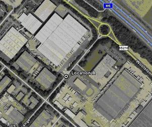
4 List of addresses extracted from TomTom car navigator David Last


5 Plot of addresses extracted from TomTom car navigator David Last


6 Picture: David Last


7 Picture: Audi Bedienungsanleitung englisch David Last
8 Quality of evidence from satellite navigators At its worst List of addresses, but No identity, no times or dates No route, no evidence of visit No specific vehicle Nevertheless Powerful leads Linked to other evidence David Last

9 Quality of evidence from satellite navigators At its best Name and home address Addresses in order, favourites Language and preferences Telephone numbers and calls and possibly. Multiple timed and dated tracks David Last


10 Contact: David Last


11 David Last


12 GPS Tracking Evidence comes from: Law enforcement covert operations Employers Commercial tracking companies Motor insurance companies Criminals Pictures: David Last


13 David Last

14 Contact: David Last


15 Pictures: dreamtimes David Last


16 Satellite Failures Official announcement: "A significant GPS anomaly occurred on 1 Jan 04, resulting in the transmission of Hazardously Misleading Information." Solar flares Sources: Vogel, Macabiau & Suard, Effect of a GPS Anomaly on Different GNSS Receivers, ION GNSS 2005, Long Beach, CA, Sep 13-16, 2005, Hoppe & Walterfang, Investigation of a GPS Satellite Problem with respect to DGPS and GPS users, European Journal of Navigation, May 2004, David Last


17 David Last
18 GPS plus GLONASS (Russia) Compass-Beidou (China) and all the augmentations: QZSS (Japan) GALILEO (Europe) IRNSS (India)

19 Galileo Europe s future satellite navigation system? David Last, University of Wales, Bangor

20 David Last
21 Galileo - The objectives: Independence of the USA Share of the satnav industry Second navigation system plus a Europe-wide Big Project David Last
22 GALILEO European Satellite Navigation System Open Service: free, like civil GPS, improved quality and reliability. Commercial Service: enhanced performance, service guarantee. Safety-of-Life Service: very high quality and integrity, for safety-critical applications Public Regulated Service (PRS): encrypted, jamming-resistant, for EU public authorities David Last, University of Wales, Bangor


23 GPS plus GLONASS (Russia) Compass-Beidou (China) and all the augmentations: QZSS (Japan) GALILEO (Europe) IRNSS (India)
24 David Last
25 GPS and GSM Jammer Picture: David Last

26 David Last

27
28

29 David Last

30 David Last

31 David Last

32 David Last


33 GPS chaos: How a $30 box can jam your life 21:00 06 March 2011 by David Hambling


34 David Last


35


36 Pictures: wikipedia.org, dailymail.co.uk, insidegnss.com, youtube.com

37 David Last


38
39 Options to mitigate jamming and spoofing Detect and enforce Dead-reckoning Enhanced Loran Picture: David Last

 - soon at 6 more")
40 The GLAs prototype eloran system is on the air - serving the Port of Dover and the UK section of the Dover Strait First stage eloran Initial Operational Capability (IOC) - soon at 6 more busy ports

41 Increasing use of GPS evidence Evidence from satnavs and tracking data More and more devices will include GPS New satellite systems but more of the same? Threats from failures and solar storms Jamming and spoofing attacks by criminals
Protection Augmentation Toughness and Alternatives of GNSS. Melaha 2016 Concord Al-Salam Hotel Cairo, April 25,2016 Refaat Rashad
 Protection Augmentation Toughness and Alternatives of GNSS Melaha 2016 Concord Al-Salam Hotel Cairo, April 25,2016 Refaat Rashad Road Map of the Presentation 1- How Good are GNSS 2- How Vulnerable are
European GNSS: Galileo and EGNOS for next generation Road Charging
 European GNSS: Galileo and EGNOS for next generation Road Charging 20 th October 2014 Gian Gherardo Calini European GNSS Agency (GSA) GNSS have made a huge impact in our society it is key in Road transportation
King AbdulAziz University. Faculty of Environmental Design. Geomatics Department. Mobile GIS GEOM 427. Lecture 3
 King AbdulAziz University Faculty of Environmental Design Geomatics Department Mobile GIS GEOM 427 Lecture 3 Ahmed Baik, Ph.D. Email: abaik@kau.edu.sa Eng. Fisal Basheeh Email: fbasaheeh@kau.edu.sa GNSS
RESPONSE TO THE HOUSE OF COMMONS TRANSPORT SELECT COMMITTEE INQUIRY INTO GALILEO. Memorandum submitted by The Royal Academy of Engineering
 RESPONSE TO THE HOUSE OF COMMONS TRANSPORT SELECT COMMITTEE INQUIRY INTO GALILEO Memorandum submitted by The Royal Academy of Engineering September 2004 Executive Summary The Royal Academy of Engineering
Extreme space weather: Geomagnetic storms, GNSS disruptions and the impact on vital functions in society
 Extreme space weather: Geomagnetic storms, GNSS disruptions and the impact on vital functions in society Fredrik Marsten Eklöf FOI, Informationssystem fredrik.eklof@foi.se, 0709-277426 Global Navigation
Satellite-Based Augmentation System (SBAS) Integrity Services
 Integrity Services") Satellite-Based Augmentation System (SBAS) Integrity Services Presented To: Munich, Germany Date: March 8, 2010 By: Leo Eldredge, Manager GNSS Group, FAA FAA Satellite Navigation Program 2 Wide Area Augmentation
Satellite-Based Augmentation System (SBAS) Integrity Services Presented To: Munich, Germany Date: March 8, 2010 By: Leo Eldredge, Manager GNSS Group, FAA FAA Satellite Navigation Program 2 Wide Area Augmentation
Geoscience & Positioning, Navigation and Timing Services for Canadians
 Geoscience & Positioning, Navigation and Timing Services for Canadians Calvin Klatt, Ph.D. Director and Chief Geodesist Natural Resources Canada / Directeur et géodésien principal Ressources naturelles
HOW TO RECEIVE UTC AND HOW TO PROVE ACCURACY
 HOW TO RECEIVE UTC AND HOW TO PROVE ACCURACY Marc Weiss, Ph.D. Independent Consultant to Booz Allen Hamilton Weiss_Marc@ne.bah.com Innovation center, Washington, D.C. JANUARY 23, 2018 HOW DO YOU GET UTC
CLICK HERE TO KNOW MORE
 CLICK HERE TO KNOW MORE Should GNSS Become a National Critical Infrastructure? Ooi Wei Han, Noordin Ahmad, Shahrizal IM National Space Agency (ANGKASA) Ministry of Science, Technology and Innovation (MOSTI)
Time Firewall: Securing the GNSS receivers against Spoofing/Jamming. Shemi Prazot AccuBeat
 Time Firewall: Securing the GNSS receivers against Spoofing/Jamming Shemi Prazot AccuBeat 1 The need The GNSS systems are widely used for both navigation and timing in civilian infrastructures and military
GPS Jamming and its impact on maritime navigation
 GPS Jamming and its impact on maritime navigation Dr Alan Grant Research and Development - Special Interest Group 10 th May 2010 Use of GPS in the maritime sector GPS has become the normal means for maritime
GPS Interference Detection & Mitigation
 GPS Interference Detection & Mitigation GAARDIAN GNSS AVAILABILITY ACCURACY RELIABILITY and INTEGRITY ASSESSMENT for TIMING and NAVIGATION A Technology Strategy Board funded collaboration Charles Curry,
Experience with Radio Navigation Satellite Service (RNSS)
") Experience with Radio Navigation Satellite Service (RNSS) International Satellite Communication Symposium International Telecommunication Union (ITU) Geneva, 13-14 June 2016 MITOME, Takahiro Co-Chair of
Experience with Radio Navigation Satellite Service (RNSS) International Satellite Communication Symposium International Telecommunication Union (ITU) Geneva, 13-14 June 2016 MITOME, Takahiro Co-Chair of
Lecture-1 CHAPTER 2 INTRODUCTION TO GPS
 Lecture-1 CHAPTER 2 INTRODUCTION TO GPS 2.1 History of GPS GPS is a global navigation satellite system (GNSS). It is the commonly used acronym of NAVSTAR (NAVigation System with Time And Ranging) GPS (Global
Webinar. 9 things you should know about centimeter-level GNSS accuracy
 Webinar 9 things you should know about centimeter-level GNSS accuracy Webinar agenda 9 things you should know about centimeter-level GNSS accuracy 1. High precision GNSS challenges 2. u-blox F9 technology
PRELIMINARY PROGRAMME
 ICG EXPERTS MEETING: GLOBAL NAVIGATION SATELLITE SYSTEMS SERVICES 14-18 December 2015 Vienna International Centre, Vienna, Austria Organized by International Committee on Global Navigation Satellite Systems
GPS Jamming Quantifying the Threat
 GPS Jamming Quantifying the Threat GNSS Vulnerability Countering the Threat 13 th Feb 2013 Prof. Charles Curry B.Eng, C.Eng, FIET Managing Director Chronos Technology Ltd NPL, Teddington, London Presentation
The Navigation of Navigation
 The Navigation of Navigation Professor David Last Past-President, Royal Institute of Navigation jdl@navaid.demon.co.uk Abstract Satellite navigation is an exceptionally successful technology. It benefits
Update from the United States Space-Based Positioning, Navigation, and Timing Advisory Board
 Update from the United States Space-Based Positioning, Navigation, and Timing Advisory Board John W. Betz, PhD PNTAB Member Presented to ICG-12, Kyoto, Japan December 2017 Approved for Public Release;
Note that MIFD II will also be influencing standards in the US.
 1 2 Why should the Financial Sector care? Note that MIFD II will also be influencing standards in the US. The best contingency solutions is one that includes a Resilience Triad : GPS/GNSS, eloran, and
ICG GNSS Interoperability Workshop A Civil Aviation Perspective
 Approved for Public Release; Distribution Unlimited. 13-1907. ICG GNSS Interoperability Workshop A Civil Aviation Perspective C h r i s t o p h e r J. H e g a r t y A p r i l 2 0 1 3 Disclaimer: The contents
GPS Interference & Space Weather Real or Imagined Vulnerability?
 GPS Interference & Space Weather Real or Imagined Vulnerability? Prof. Charles Curry B.Eng, FIET Managing Director Chronos Technology Ltd 7 th Nov 2012 ITSF Nice, France Presentation Contents Background
School of Civil & Environmental Engineering, UNSW, Sydney, Australia. Chris Rizos. President Australian Institute of Navigation
 The Threat to Space Based Service (for PNT applications) School of Civil & Environmental Engineering, UNSW, Sydney, Australia Chris Rizos President Australian Institute of Navigation Outline GNSS... a
The topic we are going to see in this unit, the global positioning system, is not directly related with the computer networks we use everyday, but it
 The topic we are going to see in this unit, the global positioning system, is not directly related with the computer networks we use everyday, but it is indeed a kind of computer network, as the specialised
Developing a GNSS resiliency framework for timing receivers. By Guy Buesnel and Adam Price Spirent Communications, October 2017
 Developing a GNSS resiliency framework for timing receivers By Guy Buesnel and Adam Price, October 2017 Overview of Spirent Positioning and Timing Mobile Devices Military Applications Commercial Air Travel
Emergency Services Sector (Law Enforcement, EMS & Incident Management) Use of Positioning, Navigation and Timing (PNT) Services
 Use of Positioning, Navigation and Timing (PNT) Services") Emergency Services Sector (Law Enforcement, EMS & Incident Management) Use of Positioning, Navigation and Timing (PNT) Services These comments are based upon public and private assertions made by representatives
Emergency Services Sector (Law Enforcement, EMS & Incident Management) Use of Positioning, Navigation and Timing (PNT) Services These comments are based upon public and private assertions made by representatives
GNSS: CNS Dependencies
 GNSS: CNS Dependencies Lendina Smaja DATM/RDS/NAV 10 March 2015 Agenda The Future Technical Environment GNSS GNSS Supporting CNS Loss of Signal Impact GNSS: CNS Dependencies 2 Original FANS CNS/ATM Concept
Mobile Security Fall 2015
 Mobile Security Fall 2015 Patrick Tague #8: Location Services 1 Class #8 Location services for mobile phones Cellular localization WiFi localization GPS / GNSS 2 Mobile Location Mobile location has become
Global Navigation Satellite Systems (GNSS)
") Global Navigation Satellite Systems (GNSS) Pat Norris MRAeS, FRIN LogicaCMG Business Development Manager Chairman, RAeS Space Group LogicaCMG 2006. All rights reserved 2 Global Navigation Satellite Systems
Global Navigation Satellite Systems (GNSS) Pat Norris MRAeS, FRIN LogicaCMG Business Development Manager Chairman, RAeS Space Group LogicaCMG 2006. All rights reserved 2 Global Navigation Satellite Systems
Black Swans, White Elephants and Delivering a New National Timescale with eloran
 Black Swans, White Elephants and Delivering a New National Timescale with eloran Charles Curry BEng, CEng, FIET Managing Director Chronos Technology Ltd SFR, Paris 18 th July 2014 PNT First Experiences
Communications Sector. Use of Positioning, Navigation and Timing (PNT) Services
 Services") Communications Sector Use of Positioning, Navigation and Timing (PNT) Services These comments are based upon public and private assertions made by representatives of this Critical Infrastructure/Key Resource
Communications Sector Use of Positioning, Navigation and Timing (PNT) Services These comments are based upon public and private assertions made by representatives of this Critical Infrastructure/Key Resource
Developments in Satellite Navigation and Wireless Spectrum
 Developments in Satellite Navigation and Wireless Spectrum Chris Hegarty 14 June 2010 Christopher J. Hegarty, D.Sc. The MITRE Corporation chegarty@mitre.org 781-271-2127 (Tel) The contents of this material
MDTS 5734 : Guidance Lecture 5 : Global Positioning Systems. Gerard Leng, MDTS, NUS
 MDTS 5734 : Guidance Lecture 5 : Global Positioning Systems Question : What do we really need for trans-continental navigation? Hint below : It s not GPS!?! First London to Singapore flight by Imperial
Where Next for GNSS?
 Where Next for GNSS? Professor Terry Moore Professor of Satellite Navigation Nottingham The University of Nottingham Where Next for GNSS Back to the Future? Professor Terry Moore Professor of Satellite
Fast convergence of Trimble CenterPoint RTX by regional augmentation
 Fast convergence of Trimble CenterPoint RTX by regional augmentation Dr. Ralf Drescher Trimble Terrasat GmbH, Munich EGU General Assembly 2015, Vienna Thursday, 16 April 2015 Outline Introduction CenterPoint
Information Technology Sector. Use of Positioning, Navigation and Timing (PNT) Services
 Services") Information Technology Sector Use of Positioning, Navigation and Timing (PNT) Services These comments are based upon public and private assertions made by representatives of this Critical Infrastructure/Key
Information Technology Sector Use of Positioning, Navigation and Timing (PNT) Services These comments are based upon public and private assertions made by representatives of this Critical Infrastructure/Key
Future of GNSS Receivers. Éamonn Glennon
 Future of GNSS Receivers Éamonn Glennon Future of GNSS Receivers? What have we got now? What do customers want? What does government want? What are the problems with current receivers? What type of receivers?
Galileo Aktueller Stand der Entwicklung
 Galileo Aktueller Stand der Entwicklung Is there a positive perspective for Galileo? Dr. Philipp Berglez TeleConsult Austria GmbH GSV-Forum Galileo das europäische Satellitennavigationssystem eine neue
Performance Evaluation of Differential Global Navigation Satellite System with RTK Corrections
 IOSR Journal of Electronics and Communication Engineering (IOSR-JECE) e-issn: 2278-2834,p- ISSN: 2278-8735.Volume 9, Issue 2, Ver. VI (Mar - Apr. 2014), PP 43-47 Performance Evaluation of Differential
Global Positioning Systems Directorate
 Space and Missile Systems Center Global Positioning Systems Directorate GPS Program Update to 8 th Stanford PNT Symposium 30 Oct 2014 Col Matt Smitham Deputy Director, GPS Directorate Global Positioning
DESIGN AND IMPLEMENTATION OF INTEGRATED GLOBAL NAVIGATION SATELLITE SYSTEM (GNSS) RECEIVER. B.Tech Thesis Report
 RECEIVER. B.Tech Thesis Report") Indian Institute of Technology Jodhpur DESIGN AND IMPLEMENTATION OF INTEGRATED GLOBAL NAVIGATION SATELLITE SYSTEM (GNSS) RECEIVER B.Tech Thesis Report Submitted by Arun Balajee V, Aswin Suresh and Mahesh
Indian Institute of Technology Jodhpur DESIGN AND IMPLEMENTATION OF INTEGRATED GLOBAL NAVIGATION SATELLITE SYSTEM (GNSS) RECEIVER B.Tech Thesis Report Submitted by Arun Balajee V, Aswin Suresh and Mahesh
International collaboration on open source scientific software: latest developments in gogps positioning engine. FOSS4G 2013 Osaka 7 November 2013
 International collaboration on open source scientific software: latest developments in gogps positioning engine Eugenio Realini Daisuke Yoshida Hirofumi Hayashi Venkatesh Raghavan RISH, Kyoto University
Position, Position, Position
 Glenn Coianiz Exploris Pty Ltd Position, Position, Position A Brief History BC navigators lats (easy 0-90 using sun) longs (not so easy dead reckoning) relationship between time and longitude Various attempts
European GNSS Evolution
 Ref. Ares(204)902599 - /06/204 European GNSS Evolution Hermann Ebner Galileo and EGNOS Programme Management DG Enterprise and Industry Content Introduction 2 2 Major Challenges for EGNSS Evolution 3 EGNSS
BeiDou: Bring the World and China to Your Doorstep
 IGS Workshop 2012-ICG Working Group A BeiDou: Bring the World and China to Your Doorstep China Satellite Navigation Office 2012.7.25 Olsztyn, Poland 1 Contents I. Development Schemes II. Performance III.
Nigerian Communications Satellite Ltd. (NIGCOMSAT)
") OVERVIEW OF NIGERIAN SATELLITE AUGMENTATION SYSTEM COMMENCING WITH PILOT DEMONSTRATION TO VALIDATE NATIONAL WORK PLAN presented by Dr. Lawal Lasisi Salami, NIGERIAN COMMUNICATIONS SATELLITE LTD UNDER FEDERAL
OVERVIEW OF NIGERIAN SATELLITE AUGMENTATION SYSTEM COMMENCING WITH PILOT DEMONSTRATION TO VALIDATE NATIONAL WORK PLAN presented by Dr. Lawal Lasisi Salami, NIGERIAN COMMUNICATIONS SATELLITE LTD UNDER FEDERAL
Wide Area Time distribution Via eloran. NASPI WG Meeting
 Wide Area Time distribution Via eloran NASPI WG Meeting March 22 2017 This work is supported through a Cooperative Research and Development Agreement (CRADA) with the Department of Homeland Security (DHS)
Principal Investigator Co-Principal Investigator Co-Principal Investigator Prof. Talat Ahmad Vice-Chancellor Jamia Millia Islamia Delhi
 Subject Paper No and Title Module No and Title Module Tag Geology Remote Sensing and GIS Concepts of Global Navigation Satellite RS & GIS XXXIII Principal Investigator Co-Principal Investigator Co-Principal
Signal Structures for Satellite-Based Navigation: Past, Present, and Future*
 Signal Structures for Satellite-Based Navigation: Past, Present, and Future* John W. Betz 23 April 2013 *Approved for Public Release; Distribution Unlimited. 13-0908. The contents of this material reflect
Three Wishes. and an elaboration. For Reception of. Professor Bradford Parkinson Stanford University. (these are my personal views)
") Three Wishes and an elaboration For Reception of Professor Bradford Parkinson Stanford University (these are my personal views) Three Wishes - Dr, Parkinson 2017 1 Good News: World-wide dependency on GNSS
Three Wishes and an elaboration For Reception of Professor Bradford Parkinson Stanford University (these are my personal views) Three Wishes - Dr, Parkinson 2017 1 Good News: World-wide dependency on GNSS
Challenges and Solutions for GPS Receiver Test
 Challenges and Solutions for GPS Receiver Test Presenter: Mirin Lew January 28, 2010 Agenda GPS technology concepts GPS and GNSS overview Assisted GPS (A-GPS) Basic tests required for GPS receiver verification
GPS & other Radio Time sources
 GPS & other Radio Time sources Anthony Flavin, MIET Chronos Technology Ltd Wireless Heritage SIG Time for Telecoms British Science Museum Friday 16th April 2018 Chronos Technology: COMPANY PROPRIETARY
in the economy United Nations Eleventh Meeting of the International Committee on Global Navigation Satellite Systems (ICG-11) and the 17th Meeting of
 and the 17th Meeting of") Applications of highprecision GNSS solutions in the economy United Nations Eleventh Meeting of the International Committee on Global Navigation Satellite Systems (ICG-11) and the 17th Meeting of the Providers'
Applications of highprecision GNSS solutions in the economy United Nations Eleventh Meeting of the International Committee on Global Navigation Satellite Systems (ICG-11) and the 17th Meeting of the Providers'
Special Committee SC-159 Navigation Equipment Using the Global Navigation Satellite System (GNSS) (Version 13)
 (Version 13)") RTCA Paper No. 307-18/PMC-1839 December 13, 2018 TERMS OF REFERENCE Special Committee SC-159 Navigation Equipment Using the Global Navigation Satellite System (GNSS) (Version 13) REQUESTOR: Organization
RTCA Paper No. 307-18/PMC-1839 December 13, 2018 TERMS OF REFERENCE Special Committee SC-159 Navigation Equipment Using the Global Navigation Satellite System (GNSS) (Version 13) REQUESTOR: Organization
GPS (GNSS) Telecom Time Now and Future 2011 Telcordia-NIST-ATIS Workshop on Synchronization in Telecommunications Systems May 10-12, 2011
 Telecom Time Now and Future 2011 Telcordia-NIST-ATIS Workshop on Synchronization in Telecommunications Systems May 10-12, 2011") GPS (GNSS) Telecom Time Now and Future 2011 Telcordia-NIST-ATIS Workshop on Synchronization in Telecommunications Systems May 10-12, 2011 Marc A. Weiss, Ph.D. Time and Frequency Division National Institute
GPS (GNSS) Telecom Time Now and Future 2011 Telcordia-NIST-ATIS Workshop on Synchronization in Telecommunications Systems May 10-12, 2011 Marc A. Weiss, Ph.D. Time and Frequency Division National Institute
The Future of Global Navigation Satellite Systems
 The Future of Global Navigation Satellite Systems Chris RIZOS School of Surveying & Spatial Information Systems University of New South Wales Sydney, NSW 2052, AUSTRALIA E-mail: c.rizos@unsw.edu.au Abstract
The Navigation of Navigation
 The Navigation of Navigation 2014 PNT Challenges & Opportunities Symposium Stanford University 29 October 2014 Professor David Last Past President, Royal Institute of Navigation Ladies and Gentlemen, Good
Current State-of-the-Art Tracking & Tracing Dr. Chaz Dixon, Telespazio VEGA UK Ltd. 31 st January 2018
 Current State-of-the-Art Tracking & Tracing Dr. Chaz Dixon, Telespazio VEGA UK Ltd 31 st January 2018 Overview Session 2: Waste Tracking via GNSS Current State-of-the-Art Tracking & Tracing Chaz Dixon,
GPS jamming
 Page 1 of 5 GPS jamming No jam tomorrow Navigation: As the uses of satellite-positioning technology continue to grow, what can be done to stop deliberate and dangerous jamming of the signals? Mar 10th
Special Committee SC-159 Navigation Equipment Using the Global Navigation Satellite System (GNSS) (Version 11)
 (Version 11)") RTCA Paper No. 094-18/PMC-1737 March 22, 2018 TERMS OF REFERENCE Special Committee SC-159 Navigation Equipment Using the Global Navigation Satellite System (GNSS) (Version 11) REQUESTOR: Organization Person
RTCA Paper No. 094-18/PMC-1737 March 22, 2018 TERMS OF REFERENCE Special Committee SC-159 Navigation Equipment Using the Global Navigation Satellite System (GNSS) (Version 11) REQUESTOR: Organization Person
GSS8000. Highlights of the GSS8000 series. Multiple Signals Combined. Comprehensive Modelling. Unmatched Pedigree and Support
 GSS8000 SERIES GSS8000 Highlights of the GSS8000 series The GSS8000 series has been designed to meet all the demanding requirements of research and development teams involved in satellite navigation and
GE 113 REMOTE SENSING
 GE 113 REMOTE SENSING Topic 9. Introduction to Global Positioning Systems (GPS) and Other GNSS Technologies Lecturer: Engr. Jojene R. Santillan jrsantillan@carsu.edu.ph Division of Geodetic Engineering
Jamming and Spoofing of GNSS Signals An Underestimated Risk?!
 Jamming and Spoofing of GNSS Signals An Underestimated Risk?! Alexander Rügamer Dirk Kowalewski Fraunhofer IIS NavXperience GmbH Fraunhofer IIS 1 Source: http://securityaffairs.co/wordpress/wpcontent/uploads/2012/02/spoofing.jpg
Space and Missile Systems Center
 Space and Missile Systems Center Global Positioning Systems Directorate GPS Status & Modernization Progress: Service, Satellites, Control Segment, and Military GPS User Equipment 3 Nov 2016 Col Steve Whitney,
Providing a Resilient Timing and UTC Service Using eloran in the United States. Charles Schue - ION PTTI Monterey, CA
 Providing a Resilient Timing and UTC Service Using eloran in the United States Charles Schue - ION PTTI Monterey, CA January 27, 2016 Motivation For a Resilient Timing and UTC Service GPS/GNSS Vulnerabilities
Future Dual Systems for Landing. The DGNSS PALS opportunity Marco Donfrancesco Intelligence & Cyber EW Sales & Mktg
 Future Dual Systems for Landing. The DGNSS PALS opportunity Marco Donfrancesco Intelligence & Cyber EW Sales & Mktg SG-175 DGNSS PALS study The study shall provide technical advice on the data link capabilities
Supplement to. Global navigation satellite systems (GNSS) L E C T U R E. Zuzana Bělinová. TELEMATIC SYSTEMS AND THEIR DESIGN part Systems Lecture 5
 L E C T U R E. Zuzana Bělinová. TELEMATIC SYSTEMS AND THEIR DESIGN part Systems Lecture 5") Zuzana Bělinová L E C T U R E 5 Supplement to Global navigation satellite systems (GNSS) Recapitulation Satellite navigation systems Zuzana Bělinová History of satellite navigation USA USA 1960 TRANSIT
Zuzana Bělinová L E C T U R E 5 Supplement to Global navigation satellite systems (GNSS) Recapitulation Satellite navigation systems Zuzana Bělinová History of satellite navigation USA USA 1960 TRANSIT
The last 25 years - GPS to multi-gnss: from a military tool to the most widely used civilian positioning solution
 1 The last 25 years - GPS to multi-gnss: from a military tool to the most widely used civilian positioning solution B. Hofmann-Wellenhof Institute of Geodesy / Navigation, Graz University of Technology
Report of the Working Group B: Enhancement of Global Navigation Satellite Systems (GNSS) Services Performance
 Services Performance") Report of the Working Group B: Enhancement of Global Navigation Satellite Systems (GNSS) Services Performance 1. The Working Group on Enhancement of Global Navigation Satellite Systems (GNSS) Service Performance
Report of the Working Group B: Enhancement of Global Navigation Satellite Systems (GNSS) Services Performance 1. The Working Group on Enhancement of Global Navigation Satellite Systems (GNSS) Service Performance
Real-Time and Multi-GNSS Key Projects of the International GNSS Service
 Real-Time and Multi-GNSS Key Projects of the International GNSS Service Urs Hugentobler, Chris Rizos, Mark Caissy, Georg Weber, Oliver Montenbruck, Ruth Neilan EUREF 2013 Symposium Budapest, Hungary, May
TACOT Project. Trusted multi Application receiver for Trucks. Bordeaux, 4 June 2014
 TACOT Project Trusted multi Application receiver for Trucks Bordeaux, 4 June 2014 Agenda TACOT Context & Solution Technical developments Test & Validation results Conclusions GNSS ease our lives GNSS is
Precise Positioning with Smartphones running Android 7 or later
 Precise Positioning with Smartphones running Android 7 or later * René Warnant, * Cécile Deprez, + Quentin Warnant * University of Liege Geodesy and GNSS + Augmenteo, Plaine Image, Lille (France) Belgian
Energy Sector. Use of Positioning, Navigation and Timing (PNT) Services
 Services") Energy Sector Use of Positioning, Navigation and Timing (PNT) Services These comments are based upon public and private assertions made by representatives of this Critical Infrastructure/Key Resource sector
Energy Sector Use of Positioning, Navigation and Timing (PNT) Services These comments are based upon public and private assertions made by representatives of this Critical Infrastructure/Key Resource sector
Research Activities and Education in TUMSAT
 Research Activities and Education in TUMSAT 2011/09/07 @ ICG-6 Akio Yasuda Tokyo University of Marine Science & Technology 1 Content Tokyo University of Marine Science and Technology Etchujima Campus of
Signals, and Receivers
 ENGINEERING SATELLITE-BASED NAVIGATION AND TIMING Global Navigation Satellite Systems, Signals, and Receivers John W. Betz IEEE IEEE PRESS Wiley CONTENTS Preface Acknowledgments Useful Constants List of
The European Commission s science and knowledge service. Joint Research Centre
 The European Commission s science and knowledge service Joint Research Centre JRC Contribution to EU GNSS Programmes Matteo Paonni 12 th Meeting of the International Committee on Global Navigation Satellite
DYNAMIC POSITIONING CONFERENCE October 7-8, Sensors II. Redundancy in Dynamic Positioning Systems Based on Satellite Navigation
 Return to Session Directory DYNAMIC POSITIONING CONFERENCE October 7-8, 2008 Sensors II Redundancy in Dynamic Positioning Systems Based on Satellite Navigation Ole Ørpen, Tor Egil Melgård, Arne Norum Fugro
Report on a Multi-GNSS Demonstration project in the Asia/Oceania region
 Report on a Multi-GNSS Demonstration project in the Asia/Oceania region - Asia Oceania is the Showcase of New GNSS Era - Japan Aerospace Exploration Agency ICG 5@Turin, Italy October 19, 2010 1 Back Ground
Development of Hong Kong GNSS infrastructure
 Development of Hong Kong GNSS infrastructure Wu Chen Department of Land Surveying and Geoinformatics (LSGI) Hong Kong Polytechnic University Hong Kong 1 Research Areas Research Areas GNSS Positioning and
02 Issue. e-navigation News. GNSS Vulnerability. Dublin Bay Digital Diamond. e-navigation. Demonstrator Update International. e-navigation.
 CORPORATE SECURITY TEAMWORK EVENTS 02 Issue e-navigation News GNSS Vulnerability Dublin Bay Digital Diamond e-navigation Demonstrator Update International e-navigation update June 2014 www.cil.ie +353
السلطة البحرية االردنية Jordan Maritime Authority
 السلطة البحرية االردنية السلطة البحرية االردنية Humans have always been interested in where things are السلطة البحرية االردنية One of the basic questions have always been where I am? which leads to where
GNSS VULNERABILITY AND CRITICAL INFRASTRUCTURE
 GNSS VULNERABILITY AND CRITICAL INFRASTRUCTURE NNF CONFERENCE 24 MAY 2012 Brynjar Hansen Senior adviser Norwegian Space Centre Lars Giske Senior adviser Norwegian Space Centre MULTI GNSS EXTERNAL COOPERATION
Bring satellites into your lab
 Bring satellites into your lab GNSS simulators from the T&M expert 5215.5042.32 02.01 PDP 1 en www.rohde-schwarz.com/gnss-solutions GNSS-Simulators--------Bring-satellites_fly_5215-5042-32_v0201.indd 7
Introduction to Global Navigation Satellite System (GNSS) Module: 1
 Module: 1") Introduction to Global Navigation Satellite System (GNSS) Module: 1 Dinesh Manandhar Center for Spatial Information Science The University of Tokyo Contact Information: dinesh@iis.u-tokyo.ac.jp Slide :
Introduction to Global Navigation Satellite System (GNSS) Module: 1 Dinesh Manandhar Center for Spatial Information Science The University of Tokyo Contact Information: dinesh@iis.u-tokyo.ac.jp Slide :
Black Swans and White Elephants GPS Jamming and Resilient PNT
 Black Swans and White Elephants GPS Jamming and Resilient PNT Charles Curry BEng, CEng, FIET Managing Director Chronos Technology Ltd ITSF 2014 4-6 th Nov 2014 Budapest, Hungary Black Swan Events Nassim
GNSS Vulnerabilities Providing Maximum User Protection
 GNSS Vulnerabilities Providing Maximum User Protection Dr. Wolfgang Schuster Centre for Transport Studies (CTS) Department of Civil and Environmental Engineering Imperial College London, UK (w.schuster@imperial.ac.uk)
Perspective of Eastern Global Satellite Navigation Systems
 POSTER 2015, PRAGUE MAY 14 1 Perspective of Eastern Global Satellite Navigation Systems Jiří SVATOŇ Dept. of Radioengineering, Czech Technical University, Technická 2, 166 27 Praha, Czech Republic svatoji2@fel.cvut.cz
1. Introduction. Quick Start Guide for GPS150 V1.02 TEL
 1. Introduction Congratulations on the purchase of your GPS150 Smart GPS/GLONASS Sensor. It is recommended that your receiver is installed by a professional installer. You will need to purchase a suitable
Introduction to Total Station and GPS
 Introduction to Total Station and GPS Dr. P. NANJUNDASWAMY Professor of Civil Engineering J S S Science and Technology University S J College of Engineering Mysuru 570 006 Introduction History GPS Overview
GPS/GNSS What is it? How Does it Work? What are its Applications?
 GPS/GNSS What is it? How Does it Work? What are its Applications? Historic Navigation Reference points in the sky used for navigation The Sun The Pole Star / North Star Southern Cross Gives Direction,
Resilience through co-primary PNT solutions: GPS and eloran. By Charles Schue September 4, 2014
 1 Resilience through co-primary PNT solutions: GPS and eloran By Charles Schue September 4, 2014 Outline The Problem: Vulnerabilities The Need: Resilience The Solution: Co-Primary GPS and eloran eloran
The Case for Recording IF Data for GNSS Signal Forensic Analysis Using a SDR
 The Case for Recording IF Data for GNSS Signal Forensic Analysis Using a SDR Professor Gérard Lachapelle & Dr. Ali Broumandan PLAN Group, University of Calgary PLAN.geomatics.ucalgary.ca IGAW 2016-GNSS
GNSS Technology Innovation Day 2: Galileo for Railways and Transport
 GNSS Technology Innovation Day 2: Galileo for Railways and Transport IGAW 2017 International GNSS Advances Workshop 21 st June 2017 Massimo Crisci (European Space Agency) Presentation Overview 1. Thematic
GBAS FOR ATCO. June 2017
 GBAS FOR ATCO June 2017 Disclaimer This presentation is for information purposes only. It should not be relied on as the sole source of information, and should always be used in the context of other authoritative
European Radio Navigation Plan. Gilles LEQUEUX, European Commission Policy Development and Strategies
 European Radio Navigation Plan Gilles LEQUEUX, European Commission Policy Development and Strategies CONTEXT - BENEFITS Space Strategy for Europe Introduction of EGNSS in EU sectoral policies Better strategic
High Precision Applications with BeiDou
 High Precision Applications with BeiDou Lei HUANG Unicore Communications, Inc May 14, 2013 Contents 1 2 3 4 Background Overview of BeiDou high precision products Applications of BeiDou high precision products
Satellite navigation From Wikipedia, the free encyclopedia
 Page 1 of 11 Satellite navigation From Wikipedia, the free encyclopedia A satellite navigation or satnav system is a system that uses satellites to provide autonomous geospatial positioning. It allows
Leadership in Resilient PNT
 www.ursanav.com www.nautelnav.com 29 November 2017 Leadership in Resilient PNT The Need for Resilient PNT Position, Navigation, and Timing, or PNT, is known as the hidden utility. Despite its widespread
Bring satellites into your lab: GNSS simulators from the T&M expert.
 Bring satellites into your lab: GNSS simulators from the T&M expert. www.rohde-schwarz.com/gnss-solutions Your challenge GNSS receiver tests can only be conclusive when they are performed under realistic
Introduction GNSS RF interference. Jan-Joris van Es (NLR) January 2018
 January 2018") Introduction GNSS RF interference Jan-Joris van Es (NLR) January 2018 Contents Introduction Definition of RF Interference Types of RF interference Mitigation introduction GNSS RF interference, January
Introduction GNSS RF interference Jan-Joris van Es (NLR) January 2018 Contents Introduction Definition of RF Interference Types of RF interference Mitigation introduction GNSS RF interference, January