METIS Second Training & Seminar Day Cairo, 6 7 November Dr. Refaat Rashad
|
|
|
- Godfrey Wheeler
- 6 years ago
- Views:
Transcription
1 METIS Second Training & Seminar Day Cairo, 6 7 November 2007 Dr. Refaat Rashad r_rashad@hotmail.com
2 About the Author Dr. Captain Refaat Rashad B.Sc University of Wales UK M.Sc University of Wales UK Ph.D University of Wales UK Master Mariner 1969 Alex Egypt Professor of Navigation, Arab Academy for Science, Technology & Maritime Transport. President of Arab Institute of Navigation (AIN) IMO Marine Expert
3 GNSS MARITIME APPLICATIONS INTRODUCTION MARITIME USERS GNSS AVAILABLITY USERS REQUIREMENTS MEDA COUNTRIES CURRENT STATUS AND ROAD MAPE
4 INTERNATIONAL MARITIME ORGANIZATION THE OBJECTIVE OF IMO IS TO ASSURE, Safety of Lives Safety of Cargo, Commodities and Trade Safety of Ports and Maritime Infrastructure Safety of Marine Life Protection of Marine Environment and Assurance of Clean Seas
5 INTERNATIONA MARITIME ORGANIZATION IMO objectives are achieved through, International Agreements, Conventions, Regulations, Rules, Recommendations, and Memorandum of Understandings. All MEDA countries are members of IMO adopted basic conventions for, Safety, Security, and Environmental Protection.
6 Navigation Requirement Performance SOLAS Ships, all ships involved in commercial operation and passenger ships irrespective to the size. Solas ships should be fitted with Global Navigation Satellite System or terrestrial system, update ship position by automatic means resolution, was adopted for civil GNSS Internationally Operated NON SOLAS SHIPS War ships -- Government vessels Ships below 150 Grt.. fishing vessel, Ships less than 500 Grt not engage in international voyage.
7 INTERNATIONAL FLEET Oil tankers Bulk carriers General cargo Container ships Ferries + passengers ships Others 336, , , , , , % 36.0% 10.0% 11.0% 01.0% 04.5% Total of world fleet at ,843 About 1800 vessel is added every year
8 INTERNATIONAL FLEET Maritime Users Oil tankers Bulk carriers General cargo Container ships Ferries + passengers ships Others
9 SERVICE ENABLERS IALA, is the International Association of Maritime Aids to Navigation and Lighthouses Authorities. It is responsible for setting standards for Maritime Radio Navigation Services, Alger, Egypt, Tunisia, Israel and Morocco are member of IALA. IHO, International Hydrographic office. It is responsible for the Nautical Charts and safe sea routes
10 MARITIME USERS PASSENGER AND CARGO SHIPS
11 TANKERS Tankers Tonnage up to 500,000 Grt of crud oil tankers Navigating around the Glob

12 BULK CARRIERS
13 GAS CARIRIER

14 WAR AND GOVERNEMET SHIPS

15 FISHING VESSELS Thousands of fishing vessels use GNSS for locating their catches

16 Leisure Crafts

17 SERVICE BOATES

18 The Evolving GNSS Panorama Europe Russian Federation China United States India Japan Australia Page 18
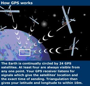
19 GNSS Milestones 1967 Transit Satellite 1978 First GPS Satellite Launched 1982 First GLONASS Satellite Launched 1996 IMO Recognized GPS & GLONASS 2000 Galileo official go ahead 2002 GNSS 1(GPS+ GLONSS+ EGNOS + WAAS ) 2004 EGNOS operational 2005 GPS L5 civil Frequency 2005 First Galileo Satellite launched- GIOVA 2006 Galileo Frequency (SIS) 2007 GPS / Galileo interoperability in progress 2012 GNSS2 (GPS + Galileo +GLONAAS + EGNOS
 55 degree inclination 20200 km height 6 Orbits period of 11hr & 56min. 8~9 Sat.")
20 Navigation Satellite Systems American GPS 24 Satellites Cons. (29) 55 degree inclination km height 6 Orbits period of 11hr & 56min. 8~9 Sat. are visible Two Services P code & C/A code Military System
21 Russian Satellite System GLONASS 24 satellites (13) Height km 3 Orbits planes Period 11hr 15min DEC. 64 Degrees Military System


22 GLONASS Modernization GLONASS GLONASS-M GLONASS-K GLONASS-KM Life-time 3 years Life-time 7 years 2 nd civil signal Life-time 10 years 3 rd civil signal

23 Galileo Galileo is the European global satellite navigation system, providing a highly accurate, guaranteed global positioning service under civilian control.

24 24 MEO Satellites Similar to GPS/ GLONASS Encrypted Security Signal Same Frequencies as GPS or Galileo? Limited Information in The Public Domain CHINA BEIDO SYSTEM COMPASS SATELLITE
25 GNSS Evolution
26
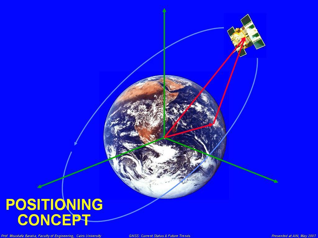
27 Satellite Positioning
28


29 DIFFRENTIAL SYSTEMS

30 DIFFERENTIAL CONCEPT -17m +3m +11m -17m +3m +11m Transmits pseudorange corrections

31 WIDE AREA AUGMENTATION Corrections available over a wide area Fewer Reference Stations
32 Other Initiatives BEIDOU COMPASS MSAS QZSS WAAS EGNOS GAGAN IRNSS WAAS
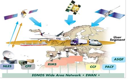
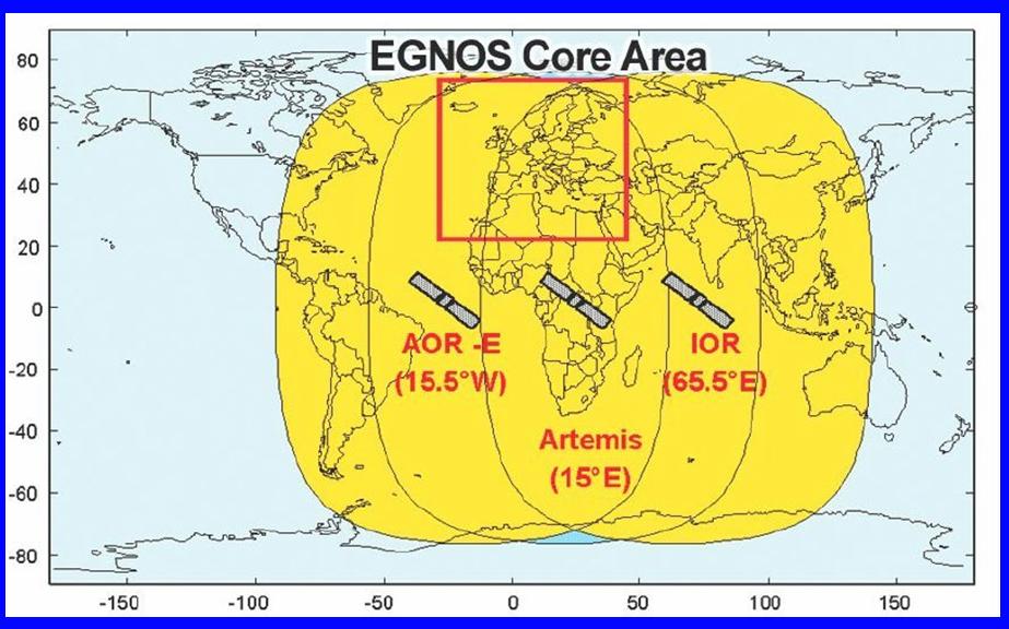
33 EGNOS
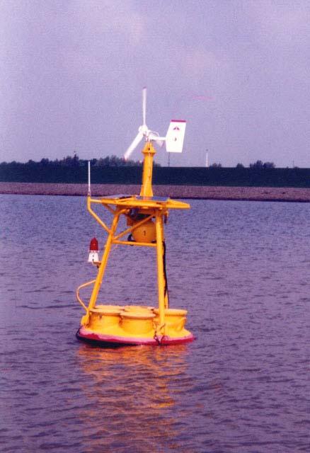
34
35
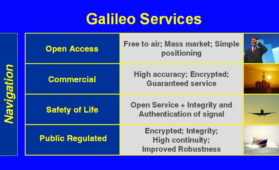
36 Galileo Services Navigation Emergency Free Encrypted Open Access Open Service Commercial Public Regulated S&R Simple Integrity Con. Integ. Precise Con. Integ Return Lin
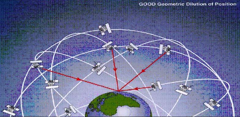
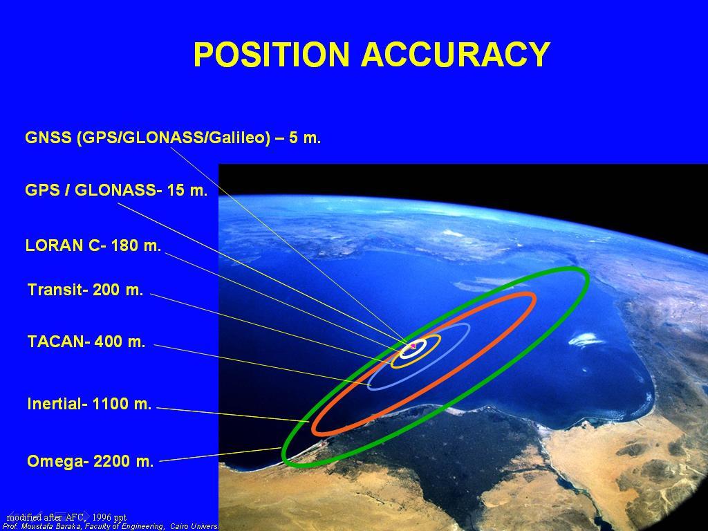
37 USER REQUIRIMENTS Availability of the System Accuracy Reliability Continuity Accessibility Integrity
38 AVAILABILITY
39
40 GNSS Navigation Application Maritime Application Open Sea & Harbor Routing Automatic Identification System (AIS) Narrow channel Navigation Control of Dangerous Goods Container Tracking Mapping &Charting Hydrographic Surveying Pipes and Cable laying Buoying Dredging Control
41 Safety Critical Transportation

42 Precise Locations of Buoys

43 Monitoring of Both Containers and Containerships

44 AUTOMATIC IDETIFICATION SYSTEM AIS is mandatory system for Solas ships, It enables ships to identify their Names, Particulars, Direction, Speed, Position and Intention Maneuvering. Receive Automatically Similar Information from Ships Equipped with AIS. Exchange Data with Shore

45 Hydrographic Surface & Underwater Operations

46 NAVIGATION IN CONFIEND WATERWAYS

47 PORTS Approaches to ports and navigational channels

48 Monitoring of Vessels in Particular Routs

49 SPECIAL MARINE OPERATION Specifying Boundaries of dangerous and prohibited areas

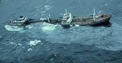
50 Vessels Traffic And River Information Services VTS and RIS are shore based centers provide navigation services in approaches of Ports and Inland Waterways
51 Professional Applications Observing the changes of sea level Dredging operations Locating wrecks Laying pipe lines Salvage of sinking vessels Dynamic Positioning Positioning of oil rigs Fixing of Satellite sea launch platforms

52 Positioning Of Huge Offshore Platform

53 MEGA OIL RIGS

54 Dynamic positioning Offshore platforms, floating drills and sea-base Satellite launching relay on GNSS-base dynamic positioning

55 GMDSS GLOBAL MARITIME DISTRESS SAFETTY SYSTEM

56 Emergency Applications Emergency Position Indicator Radio Beacon EPIRB

57 SAR AND SURVIVAL OPERATION
58 DISSASTERS

59 MEDA COUNTRIES
60 EGYPT External maritime freight exceeds ports 54 million tons/year. 15 sea ports, 6 of them on Mediterranean and 9 on the red sea. Alex port is the largest port of Egypt Suez canal is major important waterway for international shipping more than 18,000 ships passes the canal every year of an average of 40 vessels per day. VTS, AIS are implemented in Suez Canal Gulf of Suez Aqaba and in most Egyptian ports. Inland, River navigation comprises of passenger ships and barges. They are potential for GNSS monitoring based on VTS and AIS systems.

61 EGYPT CON. Damietta Alexandria Dekheila Said Egypt Sukhna Suez Adabia Safaga VTS Installations in Egypt Gulf of Suez, VTS system Golf of Aqaba VTS system Suez Canal VTMIS VTS for Egyptian Ports Most of the Egyptian Maritime ports have VTS station (VTMS) to control and manage the port ships traffic. AIS: Automatic Identification System 6 MARINE DGPS BEACONS ARE DEPLOYED ON MEDIT. AND RED SEA COAST


62 INLAND TRANSPORTATION The inland waterway network which is a specificity of Egypt in the MEDA region is km in length There is a possibility o cover the entire river valley with additional DGPS beacons to assure safety of navigation
63 Egypt GNSS Projects River Nile Bathymetry DGPS digital maps for safe Navigation System Potentials for real time tracking and monitoring. DGPS beacons to support satellite based positioning

64 ALGER Alger is dependent upon maritime transport for its external trade Pob.,32 mil., GDP about 54 Bill, per capita 1720$ 11 Sea ports open to international traffic spread along 1200 km 8 of 11 ports exceeded one million tons cargo transport. 80 % of Alger cargo are containerized Container positioning services is provided by (OR Bcomm) company. Ports are so fare not equipped nether AIS or VTS. EGNOS/GALILEO can provide added values for commercial and safety purposes.
65 Alger Con. Alger is dependent upon maritime transport for its external trade Sea ports open to international traffic spread along 1200 km 8 of 11 ports exceeded one million tons cargo transport. 80 % of Alger cargo are containerized Container positioning services is provided by (OR Bcomm) company. Ports are so fare not equipped nether AIS or VTS. EGNOS/GALILEO can provide added values for commercial and safety purposes. One experimental DGPS is operational

66 TURKEY Turkish Ports have a leading turnover role in MEDA countries with over 130 million ton Government and private operated ports (40) AUIS, VTS are implemented in most of Turkish ports and AEEAN Sea and Black sea Turkey also prepares to deploy DGPS, Beacons, how ever the system is not yet operated, but potential to be linked with EGNOS as and additional RIMS. Maritime Galileo (MARGAL) project is to enhance the application of Galileo/EGNOS in maritime operation specially security and safety Ports approach + docking Inland water ways monitoring Precise navigation TWO DGPS BEACON TO BE OPERATED Ports in Black Sea Turkish Strait Marimara Sea, Aegean sea and Medit. Sea ports are about 70 ports and terminals
.")
67 MOROCCO SOLASA+SAR CONVENTIONS ARE RATIFIED BY THE GOVERNMENT VTS IN TANGIER JOINTLY OPERATED WITH TARIFA VTS IN SPAIN MOROCC IS AN ACTIVE MEMBER OF MIDT.MOU FOR PORT STATE CONTRORL AIS IS IMPLEMENTED IN THE APPROACHEC OF MOROCCO PORTS VESSELES AND CONTAINER TRAKING BY GNSS(GPS SEVICES FOR CONTAINER LOCALISATION ARE DEPLOYED BY ORBCOM MAGREB). MAIN PORTS, CASABLANCA AGADIR NADOR AND JORF LASFAR Pop. 29 Mil., GDP 35Bill., per capita 1170$.

68 SYRIA TWO MAJOR PORTS IN SYRIA LATAKIA AND TARTOUS IN ADDITION TO OIL TERMINAL IN BAN YAS THEY ARE GOVERMEMENT OWENED AND OPERATED BOTH PORTS ARE SOLAS, SAR ANDCONVENTION RAIFIED.


69 TUNIS BOTH SOLAS AND SAR CON ARE RATIFIED TUNIS IS MEMBER OF MEDIT. MOU, PSC. 8 MAJOR PORTS, MOSTLY EQUEPPED WITH VST

70 JORDAN MEMBER OF MIDET. MOU FOR PORT STATE CONROL THE MAJOR PORT OF AQABQ INCLUDES PASSENGER AND FRIEGHT CARGO THE PORT OF AQABA IS EQUIPPED WITH VTS AISSYSTEM THE COCEPT OF INTERMODAL TRNSPORT IS APPLIED

71 LEBANON LEBANN IS MEMBER OF SEVERAL IMO CONV. 4 PORTS BEIRUT,TRIPOLI, SAIDA AND SOUR 4-5 MILLION TONS OF FREIGHT ARE TRANSPORTED Pop. 4.4 Mil., GDP 17.6 Bill., per capita 3390$

72 PALESTINE STUDIES ARE READY TO BE DEVILOPED IF PEACE TREATY IS REACHED BETWEEN CONCERNED PARTIES. GAZA PORT IS POTENCIAL TO MEET THE HUGE DEMAND OF INTERNATIONAL CARGO CREATED BY DENSE POPULATION OF PALESTINE. AT PRESEN THE PORT IS USED FOR FISHING BOATS.
73 MEDA COUNTRIES MARKET PLACE POPULATION AND GNI per capita (2004) Source UNDP ,6 72, ,4 6,7 4,3 24,6 6,6 5,64,9 5,9 3,5 4,4 3,6 3,6 Algeria Egypt Israel Jordan Lebanon Marocco Palestinian Authority 31 18,6 10 7,9 7,8 Syria Tunisia Turkey Population (in millions inhabitants) GNI per capita (PPP in thousands USD)
74 INERNATIONAL TRADE OF MEDA COUNTRIS Million Tonnages Marocco Algeria Tunisia Egypt Israel Jordan Lebanon Syria Turkey
75 CONCLUSIONS GNSS should serve the navigation requirement GNSS should be reliable and of low user cost, distinction should be made between user for safety and users benefit in commercial terms GNSS Interoperable receivers are recommended Users should be timely informed of degradation of satellite performance (integrity) Galileo/EGNOS training and education programs should be available e to maritime training institutes in MEDA countries. There is Potential Demand in MEDA Region on the services of EGNOS and Galileo.
76 CONCLUSIONS Con. Galileo/EGNOSS systems will provide integrity monitoring along with suitable communications and information exchange between vessels and shore-based installations such as (VTS). The integrity monitoring concept works in a similar manner to (IALA) radio beacons and uses RTCM Messages over AIS to broadcast this information to shipping in MEDA region.

77 THANK YOU FOR YOUR ATTENTION
Protection Augmentation Toughness and Alternatives of GNSS. Melaha 2016 Concord Al-Salam Hotel Cairo, April 25,2016 Refaat Rashad
 Protection Augmentation Toughness and Alternatives of GNSS Melaha 2016 Concord Al-Salam Hotel Cairo, April 25,2016 Refaat Rashad Road Map of the Presentation 1- How Good are GNSS 2- How Vulnerable are
GNSS in Maritime and Education in Egypt
 GNSS in Maritime and Education in Egypt GNSS IN MARITIME PORTS SHIPS PORTS WATERWAYS GNSS maritime applications will help to improve: navigation. Ship operations. Traffic management. Seaport operations.
L AGENCE NATIONALE DES FREQUENCES (ANFR) From Titanic to satellite from Morse to digital Entry in a new era for the maritime community
 From Titanic to satellite from Morse to digital Entry in a new era for the maritime community") L AGENCE NATIONALE DES FREQUENCES (ANFR) From Titanic to satellite from Morse to digital Entry in a new era for the maritime community ITU regional seminar 6-8 June 2018 St-Petersburg, Russian Federation
L AGENCE NATIONALE DES FREQUENCES (ANFR) From Titanic to satellite from Morse to digital Entry in a new era for the maritime community ITU regional seminar 6-8 June 2018 St-Petersburg, Russian Federation
IMO WORLD-WIDE RADIONAVIGATION SYSTEM (WWRNS) GALILEO receiver performance standards. Submitted by the European Commission
 GALILEO receiver performance standards. Submitted by the European Commission") INTERNATIONAL MARITIME ORGANIZATION E IMO SUB-COMMITTEE ON SAFETY OF NAVIGATION 50th session Agenda item 13 2 April 2004 Original: ENGLISH WORLD-WIDE RADIONAVIGATION SYSTEM (WWRNS) GALILEO receiver performance
INTERNATIONAL MARITIME ORGANIZATION E IMO SUB-COMMITTEE ON SAFETY OF NAVIGATION 50th session Agenda item 13 2 April 2004 Original: ENGLISH WORLD-WIDE RADIONAVIGATION SYSTEM (WWRNS) GALILEO receiver performance
Status of the European EGNOS and Galileo Programmes. Frank Udnaes Galileo policy and Infrastructure group EC DG-TREN. June 2008
 Status of the European EGNOS and Galileo Programmes Frank Udnaes Galileo policy and Infrastructure group EC DG-TREN EUROPEAN COMMISSION z June 2008 Galileo An infrastructure 30 satellite Constellation
COMMUNICATIONS FOR MARITIME SAFETY AND EFFICIENCY. Francis Zachariae, Secretary-General, IALA
 COMMUNICATIONS FOR MARITIME SAFETY AND EFFICIENCY Francis Zachariae, Secretary-General, IALA IALA and its Purpose Non profit, international technical association established in 1957 Two Goals aimed at
VHF Data Exchange System (VDES)
") VHF Data Exchange System (VDES) ETSI Workshop Future Evolution of Marine Communication 7-8 November 2017 Malcolm Lyman Marketing Manager CML Microcircuits UK With acknowledgments to the members of IALA
VHF Data Exchange System (VDES) ETSI Workshop Future Evolution of Marine Communication 7-8 November 2017 Malcolm Lyman Marketing Manager CML Microcircuits UK With acknowledgments to the members of IALA
A Euro-Mediterranean Regional Plan for GNSS
 1 A Euro-Mediterranean Regional Plan for GNSS MEdiTerranean Introduction of GNSS Services Euro-Mediterranean Transport Forum - 9th Meeting Brussels 12 December 2008 2 Outline State of play for GNSS in
Market strategy update in Maritime segment. This presentation can be interpreted only together with the oral comments accompanying it
 Market strategy update in Maritime segment This presentation can be interpreted only together with the oral comments accompanying it 2 Market sub-segments and applications Recreational navigation: GNSS
GMDSS modernisation and e-navigation: spectrum needs
 ETSI Workshop "Future Evolution of Marine Communication", 7-8 November 2017, Sophia Antipolis, France GMDSS modernisation and e-navigation: spectrum needs Karlis Bogens BR Terrestrial Services Department
ESA IAP Blue Belt demonstration project:
 Page 1 ESA IAP Blue Belt demonstration project: supporting the European Maritime Safety Agency (EMSA) Blue Belt Project, by providing a service based on satellite based AIS data complementing the terrestrial
King AbdulAziz University. Faculty of Environmental Design. Geomatics Department. Mobile GIS GEOM 427. Lecture 3
 King AbdulAziz University Faculty of Environmental Design Geomatics Department Mobile GIS GEOM 427 Lecture 3 Ahmed Baik, Ph.D. Email: abaik@kau.edu.sa Eng. Fisal Basheeh Email: fbasaheeh@kau.edu.sa GNSS
RECOMMENDATION ITU-R M *
 Rec. ITU-R M.823-3 1 RECOMMENDATION ITU-R M.823-3 * Technical characteristics of differential transmissions for global navigation satellite systems from maritime radio beacons in the frequency band 283.5-315
Euromed GNSS II project/medusa: Tunisia national workshop. Euromed GNSS II national workshop, Tunis, 29 November
 Euromed GNSS II project/medusa: Tunisia national workshop Euromed GNSS II national workshop, Tunis, 29 November 2012 1 Agenda MORNING SESSION Welcome Introduction Session on all domains (road/maritime/rail/freight
ORBITAL NAVIGATION SYSTEMS PRESENT AND FUTURE TENDS
 ORBITAL NAVIGATION SYSTEMS PRESENT AND FUTURE TENDS CONTENT WHAT IS COVERED A BRIEF HISTORY OF SYSTEMS PRESENT SYSTEMS IN USE PROBLEMS WITH SATELLITE SYSTEMS PLANNED IMPROVEMENTS CONCLUSION CONTENT WHAT
The last 25 years - GPS to multi-gnss: from a military tool to the most widely used civilian positioning solution
 1 The last 25 years - GPS to multi-gnss: from a military tool to the most widely used civilian positioning solution B. Hofmann-Wellenhof Institute of Geodesy / Navigation, Graz University of Technology
METIS & MEDIGATE Conference Tunis - Tunisia
 MEdiTerranean Introduction of GNSS (Global Satellite Navigation System) Services METIS & MEDIGATE Conference Tunis - Tunisia Telespazio S.p.A. Antonella Di Fazio email: antonella.difazio@telespazio.com
Lecture-1 CHAPTER 2 INTRODUCTION TO GPS
 Lecture-1 CHAPTER 2 INTRODUCTION TO GPS 2.1 History of GPS GPS is a global navigation satellite system (GNSS). It is the commonly used acronym of NAVSTAR (NAVigation System with Time And Ranging) GPS (Global
ROUTEING OF SHIPS, SHIP REPORTING AND RELATED MATTERS. New traffic separation schemes and two-way routes in Norra Kvarken
 E SUB-COMMITTEE ON SAFETY OF NAVIGATION 57th session Agenda item 3 NAV 57/3/7 11 March 2011 Original: ENGLISH ROUTEING OF SHIPS, SHIP REPORTING AND RELATED MATTERS New traffic separation schemes and two-way
Challenges and Solutions for GPS Receiver Test
 Challenges and Solutions for GPS Receiver Test Presenter: Mirin Lew January 28, 2010 Agenda GPS technology concepts GPS and GNSS overview Assisted GPS (A-GPS) Basic tests required for GPS receiver verification
This circular summarizes the various important aspects of the LRIT system with a view to enabling companies to ensure compliance in a timely manner.
 Luxembourg, 29/10/2008 CIRCULAR CAM 02/2008 N/Réf. : AH/63353 Subject : Long-Range Identification and Tracking of Ships (LRIT) To : All ship owners, ship operators and designated persons of Luxembourg
TECHNICAL COMMITTEE 80: MARITIME NAVIGATION AND RADIOCOMMUNICATION EQUIPMENT AND SYSTEMS INTERNATIONAL ELECTROTECHNICAL COMMISSION
 TECHNICAL COMMITTEE 80: MARITIME NAVIGATION AND RADIOCOMMUNICATION EQUIPMENT AND SYSTEMS INTERNATIONAL ELECTROTECHNICAL COMMISSION IEC TECHNICAL COMMITTEE 80: MARITIME NAVIGATION AND RADIOCOMMUNICATION
DEVELOPMENT OF A DEFINITION FOR MSPS AND CONSIDERATION FOR THE HARMONIZATION OF THE FORMAT AND STRUCTURE OF MSPS
 INTERNATIONAL HYDROGRAPHIC ORGANIZATION E IMO/IHO HARMONIZATION GROUP ON DATA MODELLING Agenda item 5 15 September 2017 ENGLISH ONLY DEVELOPMENT OF A DEFINITION FOR MSPS AND CONSIDERATION FOR THE HARMONIZATION
A new Modular and Open Concept for the Maritime Integrated PNT System
 A new Modular and Open Concept for the Maritime Integrated PNT System T. Noack German Aerospace Center Institute of Communications and Navigation www.dlr.de Chart 2 MTS-2012 Maritime Integrated PNT Unit
COMMISSION IMPLEMENTING REGULATION (EU)
") 28.7.2012 Official Journal of the European Union L 202/5 REGULATIONS COMMISSION IMPLEMENTING REGULATION (EU) No 689/2012 of 27 July 2012 amending Regulation (EC) No 415/2007 concerning the technical specifications
28.7.2012 Official Journal of the European Union L 202/5 REGULATIONS COMMISSION IMPLEMENTING REGULATION (EU) No 689/2012 of 27 July 2012 amending Regulation (EC) No 415/2007 concerning the technical specifications
السلطة البحرية االردنية Jordan Maritime Authority
 السلطة البحرية االردنية السلطة البحرية االردنية Humans have always been interested in where things are السلطة البحرية االردنية One of the basic questions have always been where I am? which leads to where
European GNSS: Galileo and EGNOS for next generation Road Charging
 European GNSS: Galileo and EGNOS for next generation Road Charging 20 th October 2014 Gian Gherardo Calini European GNSS Agency (GSA) GNSS have made a huge impact in our society it is key in Road transportation
Integration of AIS functionalities
 Integration of AIS functionalities by John O. Klepsvik FARGIS 05 March 01, 2005 WORLD CLASS through people, technology and dedication WORLD CLASS through people, technology and dedication KONGSBERG March
The Future for the AIS AtoN. Michael Card Zeni Lite Buoy Co., Ltd., Japan
 The Future for the AIS AtoN Michael Card Zeni Lite Buoy Co., Ltd., Japan History Early work in USA and Europe Not compatible with UAIS First UAIS AIS AtoN was Akari-400 Launched at IALA Sydney, 8 years
GALILEO Research and Development Activities. Second Call. Area 1A. Statement of Work
 GALILEO Research and Development Activities Second Call Area 1A GNSS Introduction in the Maritime Sector Statement of Work Rue du Luxembourg, 3 B 1000 Brussels Tel +32 2 507 80 00 Fax +32 2 507 80 01 www.galileoju.com
IALA World Wide Radio Navigation Plan
 C54/9.2/14a International Association of Marine Aids to Navigation and Lighthouse Authorities AISM Association Internationale de Signalisation Maritime IALA IALA World Wide Radio Navigation Plan Edition
EGNOS/GALILEO Status. Rafael Lucas Navigation Applications and User Services Office European Space Agency
 EGNOS/GALILEO Status Rafael Lucas Navigation Applications and User Services Office European Space Agency Rafael.Lucas.Rodriguez@esa.int European Satellite Navigation Strategy GNSS1: EGNOS Civil complement
DRAFT REVISION OF IMO RESOLUTION A.860(20)
") DRAFT REVISION OF IMO RESOLUTION A.860(20) MARITIME POLICY FOR A FUTURE GLOBAL NAVIGATION SATELLITE SYSTEM (GNSS) THE ASSEMBLY, RECALLING Article 15(j) of the Convention on the International Maritime Organization
DRAFT REVISION OF IMO RESOLUTION A.860(20) MARITIME POLICY FOR A FUTURE GLOBAL NAVIGATION SATELLITE SYSTEM (GNSS) THE ASSEMBLY, RECALLING Article 15(j) of the Convention on the International Maritime Organization
MARITIME SERVICE >> GOING GLOBAL
 EUTELSAT@SEA MARITIME SERVICE >> GOING GLOBAL KU-BAND COVERAGE current coverage future coverage Eutelsat@Sea - Going Global Our maritime services first commercialised in 1990 with EutelTracs, providing
02 Issue. e-navigation News. GNSS Vulnerability. Dublin Bay Digital Diamond. e-navigation. Demonstrator Update International. e-navigation.
 CORPORATE SECURITY TEAMWORK EVENTS 02 Issue e-navigation News GNSS Vulnerability Dublin Bay Digital Diamond e-navigation Demonstrator Update International e-navigation update June 2014 www.cil.ie +353
New advanced real time smart Search and Rescue RADAR Transponder (SART)
") Current Science International Volume : 07 Issue : 02 April- June 2018 Pages: 128-134 New advanced real time smart Search and Rescue RADAR Transponder (SART) M. S. Zaghloul Electronics and Communication
Current Science International Volume : 07 Issue : 02 April- June 2018 Pages: 128-134 New advanced real time smart Search and Rescue RADAR Transponder (SART) M. S. Zaghloul Electronics and Communication
Sales Introduction SAILOR 656X GNSS SAILOR 657X DGNSS
 Sales Introduction SAILOR 656X GNSS SAILOR 657X DGNSS The most important thing we build is trust Thrane & Thrane A/S trading as Cobham SATCOM Registered No: 65 72 46 18 Registered Address: Lundtoftegaardsvej
The Future in Marine Radio Communication GMDSS. Department of Transportation United States Coast Guard
 The Future in Marine Radio Communication GMDSS Department of Transportation United States Coast Guard Do you use a Maritime Radio System? If so, the new Global Maritime Distress and Safety System (GMDSS)
CPRNW. WWNWS9/3/3/3.2 Meeting 9 20 July 2017 Agenda Item Joint MET/NAVAREA XVII and XVIII Client Survey
 CPRNW WWNWS WWNWS9/3/3/3.2 Meeting 9 20 July 2017 Agenda Item 3.3.3.2 Joint MET/NAVAREA XVII and XVIII Client Survey Submitted by Canada, NAVAREA XVII_XVIII SUMMARY Executive Summary: This document describes
The Future of Global Navigation Satellite Systems
 The Future of Global Navigation Satellite Systems Chris RIZOS School of Surveying & Spatial Information Systems University of New South Wales Sydney, NSW 2052, AUSTRALIA E-mail: c.rizos@unsw.edu.au Abstract
Government Agency Perspectives & Initiatives Canadian Coast Guard Laurent Tardif, Director, Safe Shipping
 Unclassified Government Agency Perspectives & Initiatives Canadian Coast Guard Laurent Tardif, Director, Safe Shipping Mariner s Workshop January 23, 2019 1 Overview 1 Context 2 Marine Fees 3 4 5 Update
GNSS Programme. Overview and Status in Europe
 GNSS Programme Overview and Status in Europe Inaugural Forum Satellite Positioning Research and Application Center 23 April 2007 Tokyo Presented by Thomas Naecke (European Commission) Prepared by Daniel
Overview of the global GNSS market and status of Galileo
 2012 GNSS.asia workshop Overview of the global GNSS market and status of Galileo 6 November, 2012 Taipei Justyna Redelkiewicz, European GNSS Agency European GNNS Agency supports European Commission in
ITU Service Publications (maritime) and MARS (Maritime mobile Access and Retrieval System)
 and MARS (Maritime mobile Access and Retrieval System)") ITU Service Publications (maritime) and MARS (Maritime mobile Access and Retrieval System) ITU Radiocommunication Bureau Ms. Sujiva Pinnagoda pinnagoda@itu.int BR/TSD/TPR Another BR activity Radiocommunication
ITU Service Publications (maritime) and MARS (Maritime mobile Access and Retrieval System) ITU Radiocommunication Bureau Ms. Sujiva Pinnagoda pinnagoda@itu.int BR/TSD/TPR Another BR activity Radiocommunication
Demonstrator of a Data Processing Centre (DPC) for satellite-based AIS services
 for satellite-based AIS services") Page 1 Demonstrator of a Data Processing Centre (DPC) for satellite-based AIS services 19/20 April 2012 gfabritius@cls.fr Overview of the presentation Page 2 Introducing CLS Introducing AIS / SAT-AIS Scope
Page 1 Demonstrator of a Data Processing Centre (DPC) for satellite-based AIS services 19/20 April 2012 gfabritius@cls.fr Overview of the presentation Page 2 Introducing CLS Introducing AIS / SAT-AIS Scope
CHAPTER 6 LONG RANGE NAVIGATIONAL AIDS PART I LORAN-C
 CHAPTER 6 LONG RANGE NAVIGATIONAL AIDS PART I LORAN-C 600A. Acronyms.............................................................................. 6-3 600B. Definitions.............................................................................
Satellite technology to prevent and respond in cases of maritime accidents
 United Nations International Conference on Space-based Technologies for Disaster Management "Disaster risk identification, assessment and monitoring" 23-25 October 2013, Beijing, China. Satellite technology
ATTACHMENT E. How to Conduct a GMDSS Inspection.
 Page 1 of 7 NOTE: This document is an excerpt from The Report and Order In the Matter of Amendment of the Commission's Rules Concerning the Inspection of Radio Installations on Large Cargo and Small Passenger
GE 113 REMOTE SENSING
 GE 113 REMOTE SENSING Topic 9. Introduction to Global Positioning Systems (GPS) and Other GNSS Technologies Lecturer: Engr. Jojene R. Santillan jrsantillan@carsu.edu.ph Division of Geodetic Engineering
Fugro Satellite Positioning. What we do PUBLIC. Rob Buttress Fugro Satellite Positioning AS.
 Fugro Satellite Positioning What we do Rob Buttress Fugro Satellite Positioning AS PUBLIC Fugro Satellite Positioning Who are we? Provider of GNSS augmentation signals to the offshore industry A business
Trusted for Life TM. USCG AIS Mandate. 3 rd December 10:30 am - 11:15 am
 Trusted for Life TM USCG AIS Mandate 3 rd December 10:30 am - 11:15 am The AIS Mandate McMurdo Stand 2335 CEO McMurdo UK McMurdo By the Numbers 25% Percentage of world s 406MHz beacons manufactured by
The Role of Automatic Identification System (AIS) in Enhancing Vessel Traffic Management By Capt. Ehab Ibrahim Etman
 in Enhancing Vessel Traffic Management By Capt. Ehab Ibrahim Etman") The Role of Automatic Identification System (AIS) in Enhancing Vessel Traffic Management By Capt. Ehab Ibrahim Etman Abstract The International Maritime Organization (IMO) adopted a new requirement for
The Role of Automatic Identification System (AIS) in Enhancing Vessel Traffic Management By Capt. Ehab Ibrahim Etman Abstract The International Maritime Organization (IMO) adopted a new requirement for
Geoscience & Positioning, Navigation and Timing Services for Canadians
 Geoscience & Positioning, Navigation and Timing Services for Canadians Calvin Klatt, Ph.D. Director and Chief Geodesist Natural Resources Canada / Directeur et géodésien principal Ressources naturelles
Nigerian Communications Satellite Ltd. (NIGCOMSAT)
") OVERVIEW OF NIGERIAN SATELLITE AUGMENTATION SYSTEM COMMENCING WITH PILOT DEMONSTRATION TO VALIDATE NATIONAL WORK PLAN presented by Dr. Lawal Lasisi Salami, NIGERIAN COMMUNICATIONS SATELLITE LTD UNDER FEDERAL
OVERVIEW OF NIGERIAN SATELLITE AUGMENTATION SYSTEM COMMENCING WITH PILOT DEMONSTRATION TO VALIDATE NATIONAL WORK PLAN presented by Dr. Lawal Lasisi Salami, NIGERIAN COMMUNICATIONS SATELLITE LTD UNDER FEDERAL
GMDSS communication systems
 GMDSS Basic Concepts A System Overview Functional requirements The GMDSS (Global Maritime Distress and Safety System) is specifically designed to automate a ship's radio distress alerting function, and,
GUIDELINES ON THE DESIGN AND USE OF PORTABLE PILOT UNITS INTERNATIONAL MARITIME PILOTS ASSOCIATION
 GUIDELINES ON THE DESIGN AND USE OF PORTABLE PILOT UNITS INTERNATIONAL MARITIME PILOTS ASSOCIATION WITH TECHNICAL INPUT FROM Comité International Radio-Maritime (CIRM) 2 FOREWORD With the increasing use
Assessing EGNOS Accuracy with Reference to GPS/DGPS Project
 Assessing EGNOS Accuracy with Reference to GPS/DGPS Project Prof. Capt. Mohsen Fekry Arab Academy for Science and Technology (AAST) College of Maritime Transport and Technology Member in AIN mohsenfekry@gmail.com
Experiences with Fugro's Real Time GPS/GLONASS Orbit/Clock Decimeter Level Precise Positioning System
 Return to Session Directory DYNAMIC POSITIONING CONFERENCE October 13-14, 2009 Sensors Experiences with Fugro's Real Time GPS/GLONASS Orbit/Clock Decimeter Level Precise Positioning System Ole Ørpen and
IALA S WORK IN E-NAVIGATION. Michael Card
 IALA S WORK IN E-NAVIGATION Michael Card e-navigation origins The early work of IALA on e-navigation Multiple Initiatives EfficienSea 2 STM Validation IHO S-100 and IALA S-200 Smart Navigation VDES development
RESOLUTION MSC.278(85) (adopted on 1 December 2008) ADOPTION OF THE NEW MANDATORY SHIP REPORTING SYSTEM "OFF THE COAST OF PORTUGAL - COPREP"
 (adopted on 1 December 2008) ADOPTION OF THE NEW MANDATORY SHIP REPORTING SYSTEM OFF THE COAST OF PORTUGAL - COPREP") MSC 85/26/Add.1 RESOLUTION MSC.278(85) SYSTEM OFF THE COAST OF PORTUGAL COPREP THE MARITIME SAFETY COMMITTEE, RECALLING Article 28 of the Convention on the International Maritime Organization concerning
MSC 85/26/Add.1 RESOLUTION MSC.278(85) SYSTEM OFF THE COAST OF PORTUGAL COPREP THE MARITIME SAFETY COMMITTEE, RECALLING Article 28 of the Convention on the International Maritime Organization concerning
Universal Shipborne Automatic Identification System (AIS) Transponder
 Transponder") Universal Shipborne Automatic Identification System (AIS) Transponder What is an AIS? Picture a shipboard radar display, with overlaid electronic chart data, that includes a mark for every significant
Universal Shipborne Automatic Identification System (AIS) Transponder What is an AIS? Picture a shipboard radar display, with overlaid electronic chart data, that includes a mark for every significant
RESPONSE TO THE HOUSE OF COMMONS TRANSPORT SELECT COMMITTEE INQUIRY INTO GALILEO. Memorandum submitted by The Royal Academy of Engineering
 RESPONSE TO THE HOUSE OF COMMONS TRANSPORT SELECT COMMITTEE INQUIRY INTO GALILEO Memorandum submitted by The Royal Academy of Engineering September 2004 Executive Summary The Royal Academy of Engineering
VDES: Next Generation AIS in the Review & Modernization of the GMDSS
 JCG GMDSS Symposium VDES: Next Generation AIS in the Review & Modernization of the GMDSS 19 November 2013 VDES: Next Generation AIS Contents 1. Present situation & Problems GMDSS & AIS 2. Future: from
New Funding Opportunities to Support Safety of Navigation: EGNOS and Galileo
 New Funding Opportunities to Support Safety of Navigation: EGNOS and Galileo e-navigation Underway 31 January-2 February 2017 GSA 2016 The European GNSS Agency (GSA) today: Staff: about 145 Nationalities:
Technology evolution for future radiocommunication and navigation
 Technology evolution for future radiocommunication and navigation Frances Baskerville (Secretary General) Richard Doherty (Deputy Secretary General) CIRM Who we are and what we do What is CIRM? The Worldwide
Global Maritime Distress and Safety System (GMDSS)
") Global Maritime Distress and Safety System (GMDSS) Global Maritime Distress and Safety System (GMDSS) BACKGROUNG, APPLICATION, DEFINITION GMDSS (Background) SOLAS 74 Ships 1600 TRG Radio Installation Ships
Global Maritime Distress and Safety System (GMDSS) Global Maritime Distress and Safety System (GMDSS) BACKGROUNG, APPLICATION, DEFINITION GMDSS (Background) SOLAS 74 Ships 1600 TRG Radio Installation Ships
Loran C in Europe. 34 th Annual ILA Convention and Technical Symposium October 2005 Santa Barbara
 34 th Annual ILA Convention and Technical Symposium 17-19 October 2005 Santa Barbara Loran C in Europe Jacques MANCHARD Head of the Maritime Ads to Navigation Division (Phares et Balises) Ministry of Transport,
EGYPTIAN HYDROGRAPHIC DEPARTMENT THE EGYPTIAN HYDROGRAPHIC FRAMEWORK
 gvt THE EGYPTIAN HYDROGRAPHIC FRAMEWORK The roles of a national Hydrographic Service can be summarized in collecting georeferenced data through systematic surveys at sea and along the coast related to:
The Automatic Identification System operating jointly with radar as the aid to navigation
 Scientific Journals Maritime University of Szczecin Zeszyty Naukowe Akademia Morska w Szczecinie 2013, 36(108) z. 1 pp. 156 161 2013, 36(108) z. 1 s. 156 161 ISSN 1733-8670 The Automatic Identification
Developments in Satellite Navigation and Wireless Spectrum
 Developments in Satellite Navigation and Wireless Spectrum Chris Hegarty 14 June 2010 Christopher J. Hegarty, D.Sc. The MITRE Corporation chegarty@mitre.org 781-271-2127 (Tel) The contents of this material
DRAFT ASSEMBLY RESOLUTION A. (26)
") DRAFT ASSEMBLY RESOLUTION A. (26) PROMULGATION OF MARITIME SAFETY INFORMATION The ASSEMBLY, RECALLING Article 15(j) of the Convention on the International Maritime Organization concerning the functions
DRAFT ASSEMBLY RESOLUTION A. (26) PROMULGATION OF MARITIME SAFETY INFORMATION The ASSEMBLY, RECALLING Article 15(j) of the Convention on the International Maritime Organization concerning the functions
Automatic identification system VHF data link loading
 Report ITU-R M.2287-0 (12/2013) Automatic identification system VHF data link loading M Series Mobile, radiodetermination, amateur and related satellite services ii Rep. ITU-R M.2287-0 Foreword The role
PROGRESS UPDATE AND FUTURE DIRECTIONS OF THE MARINE ELECTRONIC HIGHWAY (MEH)
") PROGRESS UPDATE AND FUTURE DIRECTIONS OF THE MARINE ELECTRONIC HIGHWAY (MEH) BACKGROUND 1. The Marine Electronic Highway Demonstration Project (MEH DP) was a 4- year regional project in the Straits of
PROGRESS UPDATE AND FUTURE DIRECTIONS OF THE MARINE ELECTRONIC HIGHWAY (MEH) BACKGROUND 1. The Marine Electronic Highway Demonstration Project (MEH DP) was a 4- year regional project in the Straits of
Maritime ISSUE 5. Excerpt from the GNSS MARKET REPORT, ISSUE 5 (2017 ) EDITOR S SPECIAL DRONES
 EDITOR S SPECIAL DRONES") Maritime EDITOR S SPECIAL DRONES ISSUE 5 Excerpt from the GNSS MARKET REPORT, ISSUE 5 (217 ) 58 Maritime Getty images GNSS applications According to the distinction provided by IMO Resolution A.915(22),
Maritime EDITOR S SPECIAL DRONES ISSUE 5 Excerpt from the GNSS MARKET REPORT, ISSUE 5 (217 ) 58 Maritime Getty images GNSS applications According to the distinction provided by IMO Resolution A.915(22),
RULES FOR THE CONSTRUCTION AND CLASSIFICATION OF MOBILE OFFSHORE DRILLING UNITS TITLE MOBILE OFFSHORE DRILLING UNITS NAUTIC AND ELECTRONICS CHAPTERS
 PARTE II RULES FOR THE CONSTRUCTION AND CLASSIFICATION OF MOBILE OFFSHORE DRILLING UNITS TITLE MOBILE OFFSHORE DRILLING UNITS SECTION 8 NAUTIC AND ELECTRONICS CHAPTERS A B C D SCOPE TECHNICAL DOCUMENTATION
GMISS IALA and Maritime Information Sharing
 International Association of Marine Aids to Navigation and Lighthouse Authorities Association Internationale de Signalisation Maritime IALA and Maritime Information Sharing R.Adm. Jean-Charles Leclair
e-navigation Progress and trends: the IHO perspective
 International Hydrographic Organization e-navigation Progress and trends: the IHO perspective Gilles Bessero Director, IHO International Hydrographic Organization Intergovernmental consultative and technical
EGNOS status and performance in the context of marine navigation requirements
 EGNOS status and performance in the context of marine navigation requirements J. Cydejko Gdynia Maritime University, Gdynia, Poland ABSTRACT: The current status of EGNOS (December 2006) is described as
JOURNAL OF MARITIME RESEARCH. The Architecture of Data Transmission in Inland Navigation
 JOURNAL OF MARITIME RESEARCH Vol XI. No. II (2014) pp 3 7 ISSN: 1697-4040, www.jmr.unican.es The Architecture of Data Transmission in Inland Navigation A. Lisaj 1,2, and P. Majzner 3 ARTICLE INFO Article
Annex 11 to Working Party 5B Chairman s Report WORKING DOCUMENT TOWARDS A PRELIMINARY DRAFT NEW REPORT ITU-R M.[SNAP]
![Annex 11 to Working Party 5B Chairman s Report WORKING DOCUMENT TOWARDS A PRELIMINARY DRAFT NEW REPORT ITU-R M.[SNAP]](/thumbs/92/108810182.jpg "Annex 11 to Working Party 5B Chairman s Report WORKING DOCUMENT TOWARDS A PRELIMINARY DRAFT NEW REPORT ITU-R M.[SNAP]") Radiocommunication Study Groups Source: Document 5B/TEMP/287 Annex 11 to Document 5B/617-E 29 November 2010 English only Annex 11 to Working Party 5B Chairman s Report WORKING DOCUMENT TOWARDS A PRELIMINARY
Radiocommunication Study Groups Source: Document 5B/TEMP/287 Annex 11 to Document 5B/617-E 29 November 2010 English only Annex 11 to Working Party 5B Chairman s Report WORKING DOCUMENT TOWARDS A PRELIMINARY
Sperry Marine Northrop Grumman
 Sperry Marine 2005 Northrop Grumman Table of Contents CHAPTER 1: CHAPTER 2: CHAPTER 3: CHAPTER 4: CHAPTER 5: CHAPTER 6: WHERE ARE YOU GOING? TRANSMITTING HEADING DEVICES DETERMINING HEADING BY SATELLITE
METIS Second Master Training & Seminar. Augmentation Systems Available in Egypt
 METIS Second Master Training & Seminar Augmentation Systems Available in Egypt By Eng. Ramadan Salem M. Sc. Surveying and Geodesy Email: ramadan_salem@link.net Page 1 Augmentation Systems Available in
Greek Maritime trials
 Greek Maritime trials Liza Panagiotopoulou KTIMATOLOGIO S.A. Greek Maritime trials took place in the framework of GALILEO Future Applications GALA (Galileo Overall Architecture Definition) Work Package
MEDUSA Expanding EGNOS horizons. UN/ICTP Workshop on the use of GNSS for Scientific Applications, Trieste (Italy), 1-5 December
, 1-5 December") MEDUSA Expanding EGNOS horizons UN/ICTP Workshop on the use of GNSS for Scientific Applications, Trieste (Italy), 1-5 December 2014 1 Contents Euromed GNSS II/MEDUSA * MEDUSA s programme of technical assistance
MEDUSA Expanding EGNOS horizons UN/ICTP Workshop on the use of GNSS for Scientific Applications, Trieste (Italy), 1-5 December 2014 1 Contents Euromed GNSS II/MEDUSA * MEDUSA s programme of technical assistance
Report on Maritime and Inland Waterways User Needs and Requirements Outcome of the European GNSS User Consultation Platform
 Report on Maritime and Inland Waterways User Needs and Requirements Outcome of the European GNSS User Consultation Platform Reference: GSA-MKD-MAR-UREQ-229399 Issue/Revision: 1.0 Date: 18/10/2018 Change
LRIT spectrum, cybersecurity and other ITU related activities
 IMSO Seminar Effective Implementation and Management of the LRIT System 15 16 February 2018, London, UK LRIT spectrum, cybersecurity and other ITU related activities Nikolai Vassiliev Chief, Terrestrial
Korea s Strategy for e-navigation. SMART-Navigation. Presented by. Bu Young, Kim. 28 May Ministry of Oceans and Fisheries Republic of Korea
 Korea s Strategy for e-navigation SMART-Navigation Presented by Bu Young, Kim 28 May 2014 Ministry of Oceans and Fisheries Republic of Korea 1 2 3 4 5 6 1. SMART- Navigation? SMART-Navigation Korea s
FURUNO DEEPSEA WORLD Class-A Universal AIS Automatic Identification System. The future today with FURUNO's electronics technology.
 R FURUNO DEEPSEA WORLD Class-A Universal AIS Automatic Identification System Model FA-100 The AIS improves the safety of navigation by assisting in the efficient navigation of ships, protection of the
AMENDMENTS TO RESOLUTION A.705(17) PROMULGATION OF MARITIME SAFETY INFORMATION
 PROMULGATION OF MARITIME SAFETY INFORMATION") E 4 ALBERT EMBANKMENT LONDON SE1 7SR Telephone: +44 (0)20 7735 7611 Fax: +44 (0)20 7587 3210 AMENDMENTS TO RESOLUTION A.705(17) PROMULGATION OF MARITIME SAFETY INFORMATION MSC.1/Circ.1287/Rev.1 24 June
E 4 ALBERT EMBANKMENT LONDON SE1 7SR Telephone: +44 (0)20 7735 7611 Fax: +44 (0)20 7587 3210 AMENDMENTS TO RESOLUTION A.705(17) PROMULGATION OF MARITIME SAFETY INFORMATION MSC.1/Circ.1287/Rev.1 24 June
Digital broadcasting systems under development within ITU-R of interest for the maritime community
 Digital broadcasting systems under development within ITU-R of interest for the maritime community Christian RISSONE ANFR rissone@anfr.fr IHO, WWNWS 5 Monaco, 2 nd October 2013 1 Background for the 500
Consolidation of Navigation Safety Regulations IMO - NCSR / MSC Updates
 Mariners Workshop - January 23 th and 24 th 2019: Consolidation of Navigation Safety Regulations IMO - NCSR / MSC Updates IMO UPDATE NCSR / MSC Sessions Outcome of the Navigation, Communications and Search
BookletChart. Sacramento River Andrus Island to Sacramento NOAA Chart A reduced-scale NOAA nautical chart for small boaters
 BookletChart Sacramento River Andrus Island to Sacramento NOAA Chart 18662 A reduced-scale NOAA nautical chart for small boaters When possible, use the full-size NOAA chart for navigation. Included Area
ANNEX ANNEX. Accompanying the document. Commission Implementing Regulation
 Ref. Ares(2018)3546601-04/07/2018 EUROPEAN COMMISSION Brussels, XXX [ ](2018) XXX draft ANNEX ANNEX Accompanying the document Commission Implementing Regulation on technical specifications for vessel tracking
Maritime Electronics Supporting Unmanned Vessels
 EU-Japan Policy Workshop Maritime Electronics Supporting Unmanned Vessels November 11 th, 2016 TAKUO KASHIWA, Ph.D Furuno Electric Co., Ltd. Agenda Positioning Technologies for Vessel s position Technologies
GPS Evidence - Where s It Taking Us?
 GPS Evidence - Where s It Taking Us? Professor David Last International Communications Data & Digital Forensics Seminars 17-21 March 2014 Picture: earthobservatory.nasa. gov//ewsroom/bluemarble/ David
Global Navigation Satellite Systems (GNSS)
") Global Navigation Satellite Systems (GNSS) Pat Norris MRAeS, FRIN LogicaCMG Business Development Manager Chairman, RAeS Space Group LogicaCMG 2006. All rights reserved 2 Global Navigation Satellite Systems
Global Navigation Satellite Systems (GNSS) Pat Norris MRAeS, FRIN LogicaCMG Business Development Manager Chairman, RAeS Space Group LogicaCMG 2006. All rights reserved 2 Global Navigation Satellite Systems
ROUTEING OF SHIPS, SHIP REPORTING AND RELATED MATTERS. Establishment of a Mandatory Ship Reporting System in the
 INTERNATIONAL MARITIME ORGANIZATION E SUB-COMMITTEE ON SAFETY OF NAVIGATION 48th session Agenda item 3 IMO NAV 48/3/2 11 April 2002 Original: ENGLISH ROUTEING OF SHIPS, SHIP REPORTING AND RELATED MATTERS
Tide & Meteorological Data over AIS
 Tide & Meteorological Data over AIS E.F.Read (Ohmex Ltd) & W.S.Heaps (ABP Ltd) THSUK Hydro8 1 Background to AIS Most significant development since RADAR Positions and Timing from GPS network 12.5 Watt
Operation and Development of BeiDou Navigation Satellite System
 Operation and Development of BeiDou Navigation Satellite System Jing Li IAIN 2015, 20 23 October Prague, Czech Republic 2 01 03 Plan and Policy 02 Status and Near-term Goal International Cooperation 3
RESOLUTION MSC.233(82) (adopted on 5 December 2006) ADOPTION OF THE PERFORMANCE STANDARDS FOR SHIPBORNE GALILEO RECEIVER EQUIPMENT
 (adopted on 5 December 2006) ADOPTION OF THE PERFORMANCE STANDARDS FOR SHIPBORNE GALILEO RECEIVER EQUIPMENT") MSC 82/24/Add.2 RESOLUTION MSC.233(82) THE MARITIME SAFETY COMMITTEE, RECALLING Article 28(b) of the Convention on the International Maritime Organization concerning the functions of the Committee, RECALLING
MSC 82/24/Add.2 RESOLUTION MSC.233(82) THE MARITIME SAFETY COMMITTEE, RECALLING Article 28(b) of the Convention on the International Maritime Organization concerning the functions of the Committee, RECALLING