Basic Principles of Weather Radar
|
|
|
- Camron West
- 6 years ago
- Views:
Transcription
1 Basic Principles of Weather Radar
2 Basis of Presentation Introduction to Radar Basic Operating Principles Reflectivity Products Doppler Principles Velocity Products Non-Meteorological Targets Summary
3 Radar RAdio Detection And Ranging Developed during WWII for detecting enemy aircraft Active remote sensor Transmits and receives pulses of E-M radiation Satellite is passive sensor (receives only) Numerous applications Detection/analysis of meteorological phenomena Defense Law Enforcement Baseball
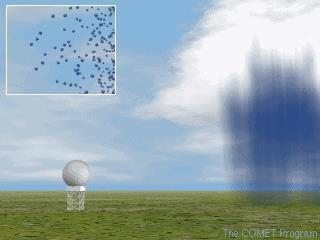
4 Weather Surveillance Radar Transmits very short pulses of radiation Pencil beam (narrow cone) expands outward Pulse duration ~ 1 μs (7 seconds per hour) High transmitted power (~1 megawatt) Listens for returned energy ( echoes ) Listening time ~ 1 ms (59:53 per hour) Very weak returns (~10-10 watt) Transmitted energy is scattered by objects on ground and in atmosphere Precipitation, terrain, buildings, insects, birds, etc. Fraction of this scattered energy goes back to radar

5 (

6 (
7 (University of Illinois WW2010 Project)

8 (University of Illinois WW2010 Project)
9
10
11 Determining Target Location Three pieces of information Azimuth angle Elevation angle Distance to target From these data radar can determine exact target location


12 Azimuth Angle Angle of beam with respect to north (University of Illinois WW2010 Project)

13 Elevation Angle Angle of beam with respect to ground (University of Illinois WW2010 Project)
14 Distance to Target D = ct/2 T pulse s round trip time (University of Illinois WW2010 Project)
15 Scanning Strategies 1 Plan Position Indicator (PPI) Antenna rotates through 360 sweep at constant elevation angle Allows detection/intensity determination of precipitation within given radius from radar Most commonly seen by general public WSR-88D performs PPI scans over several elevation angles to produce 3D representation of local atmosphere
16 Plan Position Indicator Constant elevation angle Azimuth angle varies (antenna rotates) (University of Illinois WW2010 Project)
17
18 Elevation Angle Considerations Radar usually aimed above horizon minimizes ground clutter not perfect Beam gains altitude as it travels away from radar Radar cannot see directly overhead cone of silence appears as ring of minimal/non-returns around radar, esp. with widespread precipitation Sample volume increases as beam travels away from radar
 Red numbers are elevation angles Note how beam (generally) expands with")
19 ( Red numbers are elevation angles Note how beam (generally) expands with increasing distance from radar
20 Blue numbers are heights of beam AGL at given ranges Most effective range: 124 nm
21
22 Scanning Strategies 2 Range Height Indicator (RHI) Azimuth angle constant Elevation angle varies (horizon to near zenith) Cross-sectional view of structure of specific storm (University of Illinois WW2010 Project)
23
24 Choice of Wavelength 1 P r 1 2 Typical weather radar range: cm WSR-88D: ~10 cm TV radar: ~5 cm
25 Choice of Wavelength 2 P r 1 2 P r inversely proportional to square of wavelength (i.e., short wavelength high returned power) However, shorter wavelength energy subject to greater attenuation (i.e., weaker return signal) Short wavelength radar better for detecting smaller targets (cloud/drizzle droplets) Long wavelength radar better for convective precipitation (larger hydrometeors)
26 Radar Equation for Distributed Targets 2 P r R Z c 2 where P r average returned power R c radar constant Z e equivalent radar reflectivity factor ( reflectivity ) r distance from radar to target r e
27 Radar Equation for Distributed Targets 3 P r R Z c 2 P r is: - directly proportional to reflectivity - inversely proportional to square of distance between radar and target(s) r e
28 Equivalent Radar Reflectivity Factor 1 Z e N D where N i number of scattering targets D i diameter of scattering targets v pulse volume k i 1 v i 6 i
29 Equivalent Radar Reflectivity Factor 2 Z e relates rainfall intensity to average returned power Equivalent acknowledges presence of numerous scattering targets of varying: sizes/shapes compositions (water/ice/mixture) distributions Several assumptions made (not all realistic)
30 Equivalent Radar Reflectivity Factor 3 Z e k i 1 N D Z e is: - directly proportional to number of scatterers - inversely proportional to sample volume - directly proportional to scatterer diameter raised to 6 th power - Doubling size yields 64 times the return v i 6 i
31 (University of Illinois WW2010 Project)
32 dbz dbz 10 Z log e mm m Typical units used to express reflectivity Range: 30 dbz for fog +75 dbz for very large hail
33 Scanning Modes Clear-Air Mode slower antenna rotation five elevation scans in 10 minutes sensitive to smaller scatterers (dust, particulates, bugs, etc.) good for snow detection Precipitation Mode faster antenna rotation 9-14 elevation scans in 5-6 minutes less sensitive than clear-air mode good for precipitation detection/intensity determination
34 Clear-Air Mode Precipitation Mode


35 Clear-Air Mode Precipitation Mode Greer, SC (KGSP) (
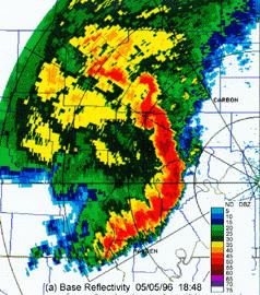
36 Reflectivity Products 1 Base Reflectivity single elevation angle scan (5-14 available) useful for precipitation detection/intensity Usually select lowest elevation angle for this purpose high reflectivities heavy rainfall usually associated with thunderstorms strong updrafts larger raindrops large raindrops have higher terminal velocities rain falls faster out of cloud higher rainfall rates hail contamination possible > 50 dbz
37 Reflectivity Products 2 Composite Reflectivity shows highest reflectivity over all elevation scans good for severe thunderstorms strong updrafts keep precipitation suspended drops must grow large enough to overcome updraft

")
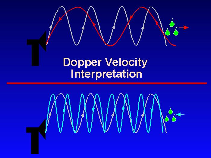
38 Base Reflectivity Composite Reflectivity Little Rock, AR (KLZK) Precipitation Mode
39 Z-R Relationships 1 Z ar b where Z reflectivity (mm 6 m -3 ) R rainfall rate (mm h -1 ) a and b are empirically derived constants
40 Z-R Relationships 2 Allow one to estimate rainfall rate from reflectivity Numerous values for a and b determined experimentally dependent on: Precipitation character (stratiform vs. convective) Location (geographic, maritime vs. continental, etc.) Time of year (cold-season vs. warm season)
41 Z-R Relationships 3 Relationship Optimum for: Also recommended for: Marshall-Palmer (Z=200R 1.6 ) East-Cool Stratiform (Z=130R 2.0 ) West-Cool Stratiform (Z=75R 2.0 ) WSR-88D Convective (Z=300R 1.4 ) Rosenfeld Tropical (Z=250R 1.2 ) General stratiform precipitation Winter stratiform precipitation - east of continental divide Winter stratiform precipitation - west of continental divide Summer deep convection Tropical convective systems (WSR-88D Operational Support Facility) Orographic rain - East Orographic rain - West Other non-tropical convection
42 Z-R Relationships 4 Reflectivity Marshall- Palmer (Z=200R 1.6 ) East-Cool Stratiform (Z=130R 2.0 ) West-Cool Stratiform (Z=75R 2.0 ) WSR-88D Convective (Z=300R 1.4 ) Rosenfeld Tropical (Z=250R 1.2 ) 15 dbz 0.25 mm h mm h mm h -1 <0.25 mm h -1 <0.25 mm h dbz 0.76 mm h mm h mm h mm h mm h dbz 1.27 mm h mm h mm h mm h mm h dbz 2.79 mm h mm h mm h mm h mm h dbz 5.59 mm h mm h mm h mm h mm h dbz mm h mm h mm h mm h mm h dbz mm h mm h mm h mm h mm h dbz mm h mm h mm h mm h mm h dbz mm h mm h mm h mm h mm h dbz mm h mm h mm h mm h mm h -1 (WSR-88D Operational Support Facility)
43 Radar Precipitation Estimation 1 1-/3-h Total Precipitation covers 1- or 3-h period ending at time of image can help to track storms when viewed as a loop highlights areas for potential (flash) flooding interval too short for some applications
44 Radar Precipitation Estimation 2 Storm Total Precipitation cumulative precipitation estimate at time of image begins when radar switches from clear-air to precipitation mode ends when radar switches back to clear-air mode can help to track storms when viewed as a loop helpful in estimating soil saturation/runoff post-storm analysis highlights areas of R+/hail no control over estimation period
 Storm Total")
 St.")
45 1-h Total Precipitation (ending at 2009 UTC 11 June 2003) Storm Total Precipitation ( June 2003 to 2009 UTC 11 June 2003) St. Louis, MO (KLSX)
46 Radar Precipitation Estimation Caveats No control over STP estimation interval Based on empirically-derived formula not always ideal for given area/season/character Hail contamination (large) water-covered ice pellets very reflective causes overestimate of precip intensity/amount Mixed precipitation character in same area convective and stratiform precipitation falling simultaneously which Z-R relationship applies? Patterns generally good, magnitudes less so
47 Doppler Effect Based on frequency changes associated with moving objects E-M energy scattered by hydrometeors moving toward/away from radar cause frequency change Frequency of return signal compared to transmitted signal frequency radial velocity

48 (
")
49 (Williams 1992)
50 (
51 Radial Velocity 1 Hydrometeors moving toward/away from radar Positive values targets moving away from radar Negative values targets moving toward radar Can be used to ascertain large-scale and small-scale flows/phenomena fronts and other boundaries mesoscale circulations microbursts
52 Radial Velocity 2 Base Velocity ground-relative good for large-scale flow and straight-line winds Storm-Relative Velocity storm motion subtracted from radial velocity good for detecting circulations and divergent/convergent flows
 Base Velocity Storm-Relative Velocity Houston, TX (KHGX) warm colors away")
53 ( Base Velocity Storm-Relative Velocity Houston, TX (KHGX) warm colors away from radar cool colors toward radar

54 mesocyclone Buffalo, NY (KBUF) 1944 UTC 28 April 2002 Storm-Relative Velocity (
55 The Doppler Dilemma 1 Pulse can only travel so far and return in time before next pulse is transmitted Distant targets may be reported as close, and/or Velocities may be aliased Pulse Repetition Frequency (PRF) transmission interval typical values Hz (cycles s -1 ) key to determining maximum unambiguous range (R max ) and velocity (V max )
56 The Doppler Dilemma 2 R max c 2PRF Maximum Unambiguous Range (R max ) Longest distance between target and radar that can be measured with confidence Inversely proportional to PRF
57 The Doppler Dilemma 3 V max PRF 4 Maximum Unambiguous Velocity (V max ) Highest radial velocity that can be measured with confidence Directly proportional to radar wavelength and PRF
58 The Doppler Dilemma 4 V R max max PRF 4 c 2PRF V max R max c 8
59 The Doppler Dilemma 5 If R actual > R max, range folding occurs distant echoes appear close to radar R app = R max R actual second-trip echoes If V actual > V max, velocity folding occurs radial velocities misreported V app = - (2V max V actual ) Sign of V max = V actual
60 The Doppler Dilemma 6 If V max = ± 25 m s -1 and target is moving away from radar at 30 m s -1 i.e., V actual = +30 m s -1 V app = - (50 30) = -20 m s -1 toward radar at slower speed! What about target moving at - 50 m s -1? V app = - [-50 (- 50)] = 0 m s -1 Target would appear to be stationary! If R max is large, then V max has to be small (and vice versa) cannot be large simultaneously!

61 Refraction Radar beam typically follows Earth s curvature ES/Week_3_2/sld006.htm

62 Subrefraction Beam tilts upward ES/Week_3_2/sld006.htm
63 Non-Meteorological Targets Ground Clutter trees mountains buildings Other Targets sun strobes anomalous propagation (AP)
64 Ground Clutter Stationary objects usually filtered out Swaying trees or towers may show up Look for drifting high reflectivity returns near radar

65 Cannon AFB, NM (KCVS) Precipitation Mode (
66 Mountain Blockage Low elevation angle scans blocked by terrain Shadows appear consistently in imagery Mainly a problem in western U.S.

67 Boise Mountains Owyhee Mountains Boise, ID (KBOI) Clear-Air Mode (


68 WSR-88D Network
69 Building Blockage Nearby building blocks beam if building is taller than antenna (~100 ft) Narrow shadows appear consistently in imagery Occurs in/near metropolitan areas

70 Houston, TX (KHGX) Precipitation Mode (
71 Other Targets 1 Sun strobes occur typically around dawn/dusk radar receives intense dose of E-M radiation along narrow radials similar strobes occur if beam intercepts intense source of microwave radiation other radars microwave repeaters

72 National Radar Mosaic Precipitation Mode Sun Strobes (
73 Other Targets 2 Anomalous propagation (AP) beam refracted into ground under very stable atmospheric conditions inversions near large bodies of water behind thunderstorms appear similar to intense precipitation compare to surface observations check satellite imagery examine higher elevation scans
 (http://virtual.clemson.edu/groups/birdrad/comment.")
74 Melbourne, FL (KMLB) Clear-Air Mode Anomalous Propagation (AP) (

75 (
76 Summary Weather surveillance radar has varied uses short-term weather forecasting hazardous weather warnings hydrologic applications Must be aware of radar s limitations WYSINAWYG What You See Is NOT ALWAYS What You Get!
ATS 351 Lecture 9 Radar
 ATS 351 Lecture 9 Radar Radio Waves Electromagnetic Waves Consist of an electric field and a magnetic field Polarization: describes the orientation of the electric field. 1 Remote Sensing Passive vs Active
ESCI Cloud Physics and Precipitation Processes Lesson 10 - Weather Radar Dr. DeCaria
 ESCI 340 - Cloud Physics and Precipitation Processes Lesson 10 - Weather Radar Dr. DeCaria References: A Short Course in Cloud Physics, 3rd ed., Rogers and Yau, Ch. 11 Radar Principles The components of
Mesoscale Atmospheric Systems. Radar meteorology (part 1) 04 March 2014 Heini Wernli. with a lot of input from Marc Wüest
 04 March 2014 Heini Wernli. with a lot of input from Marc Wüest") Mesoscale Atmospheric Systems Radar meteorology (part 1) 04 March 2014 Heini Wernli with a lot of input from Marc Wüest An example radar picture What are the axes? What is the resolution? What are the
Mesoscale Atmospheric Systems Radar meteorology (part 1) 04 March 2014 Heini Wernli with a lot of input from Marc Wüest An example radar picture What are the axes? What is the resolution? What are the
Mesoscale Meteorology: Radar Fundamentals
 Mesoscale Meteorology: Radar Fundamentals 31 January, February 017 Introduction A weather radar emits electromagnetic waves in pulses. The wavelengths of these pulses are in the microwave portion of the
PRINCIPLES OF METEOROLOCIAL RADAR
 PRINCIPLES OF METEOROLOCIAL RADAR OUTLINE OVERVIEW Sampling R max Superrefraction, subrefraction, operational impacts Sidelobes Beam Width Range Folding PRF s (Pulse Repition Frequency) PRECIPITATION ESTIMATES
SODAR- sonic detecting and ranging
 Active Remote Sensing of the PBL Immersed vs. remote sensors Active vs. passive sensors RADAR- radio detection and ranging WSR-88D TDWR wind profiler SODAR- sonic detecting and ranging minisodar RASS RADAR
Microwave Remote Sensing
 Provide copy on a CD of the UCAR multi-media tutorial to all in class. Assign Ch-7 and Ch-9 (for two weeks) as reading material for this class. HW#4 (Due in two weeks) Problems 1,2,3 and 4 (Chapter 7)
DOPPLER RADAR. Doppler Velocities - The Doppler shift. if φ 0 = 0, then φ = 4π. where
 Q: How does the radar get velocity information on the particles? DOPPLER RADAR Doppler Velocities - The Doppler shift Simple Example: Measures a Doppler shift - change in frequency of radiation due to
WEATHER RADAR CHAPTER 2
 CHAPTER 2 WEATHER RADAR INTRODUCTION Since the late 1940 s, radar has been used to track weather systems. Subsequent advances were made in radar transmitters, receivers, and other system components. However,
RADAR CHAPTER 3 RADAR
 RADAR CHAPTER 3 RADAR RDF becomes Radar 1. As World War II approached, scientists and the military were keen to find a method of detecting aircraft outside the normal range of eyes and ears. They found
Microwave Remote Sensing (1)
") Microwave Remote Sensing (1) Microwave sensing encompasses both active and passive forms of remote sensing. The microwave portion of the spectrum covers the range from approximately 1cm to 1m in wavelength.
Microwave Remote Sensing (1) Microwave sensing encompasses both active and passive forms of remote sensing. The microwave portion of the spectrum covers the range from approximately 1cm to 1m in wavelength.
Radar Reprinted from "Waves in Motion", McGourty and Rideout, RET 2005
 Radar Reprinted from "Waves in Motion", McGourty and Rideout, RET 2005 What is Radar? RADAR (Radio Detection And Ranging) is a way to detect and study far off targets by transmitting a radio pulse in the
DEVELOPMENT AND IMPLEMENTATION OF AN ATTENUATION CORRECTION ALGORITHM FOR CASA OFF THE GRID X-BAND RADAR
 DEVELOPMENT AND IMPLEMENTATION OF AN ATTENUATION CORRECTION ALGORITHM FOR CASA OFF THE GRID X-BAND RADAR S98 NETWORK Keyla M. Mora 1, Leyda León 1, Sandra Cruz-Pol 1 University of Puerto Rico, Mayaguez
Next Generation Operational Met Office Weather Radars and Products
 Next Generation Operational Met Office Weather Radars and Products Pierre TABARY Jacques PARENT-DU-CHATELET Observing Systems Dept. Météo France Toulouse, France pierre.tabary@meteo.fr WakeNet Workshop,
Radar. Seminar report. Submitted in partial fulfillment of the requirement for the award of degree Of Mechanical
 A Seminar report on Radar Submitted in partial fulfillment of the requirement for the award of degree Of Mechanical SUBMITTED TO: SUBMITTED BY: www.studymafia.org www.studymafia.org Preface I have made
ERAD Principles of networked weather radar operation at attenuating frequencies. Proceedings of ERAD (2004): c Copernicus GmbH 2004
: c Copernicus GmbH 2004") Proceedings of ERAD (2004): 109 114 c Copernicus GmbH 2004 ERAD 2004 Principles of networked weather radar operation at attenuating frequencies V. Chandrasekar 1, S. Lim 1, N. Bharadwaj 1, W. Li 1, D.
Proceedings of ERAD (2004): 109 114 c Copernicus GmbH 2004 ERAD 2004 Principles of networked weather radar operation at attenuating frequencies V. Chandrasekar 1, S. Lim 1, N. Bharadwaj 1, W. Li 1, D.
ERAD The weather radar system of north-western Italy: an advanced tool for meteorological surveillance
 Proceedings of ERAD (2002): 400 404 c Copernicus GmbH 2002 ERAD 2002 The weather radar system of north-western Italy: an advanced tool for meteorological surveillance R. Bechini and R. Cremonini Direzione
Weather Radar Systems. General Description
 General Description Our weather radars are designed for precipitation monitoring at both regional and urban scales. They can be advantageously used as gap filler of existing radar networks particularly
Technical and operational aspects of ground-based meteorological radars
 Recommendation ITU-R M.1849-1 (09/015) Technical and operational aspects of ground-based meteorological radars M Series Mobile, radiodetermination, amateur and related satellite services ii Rep. ITU-R
ELDES / METEK Weather Radar Systems. General Description
 General Description Our weather radars are designed for precipitation monitoring at both regional and urban scales. They can be advantageously used as gap fillers of existing radar networks particularly
RADAR. MIT Radiation Laboratory made similar observations in the early 1940 s (U.S. Air Corps meteorologists receiving radar training at MIT in 1943
 Radar Meteorology RADAR RAdio Detection And Ranging Has its roots in radio In 1934, after a plane disrupted radio communication, the idea for using pulses of energy for target detection was born Developed
THE NATURE OF GROUND CLUTTER AFFECTING RADAR PERFORMANCE MOHAMMED J. AL SUMIADAEE
 International Journal of Electronics, Communication & Instrumentation Engineering Research and Development (IJECIERD) ISSN(P): 2249-684X; ISSN(E): 2249-7951 Vol. 6, Issue 2, Apr 2016, 7-14 TJPRC Pvt. Ltd.
Lecture 12: Curvature and Refraction Radar Equation for Point Targets (Rinehart Ch3-4)
") MET 4410 Remote Sensing: Radar and Satellite Meteorology MET 5412 Remote Sensing in Meteorology Lecture 12: Curvature and Refraction Radar Equation for Point Targets (Rinehart Ch3-4) Radar Wave Propagation
MET 4410 Remote Sensing: Radar and Satellite Meteorology MET 5412 Remote Sensing in Meteorology Lecture 12: Curvature and Refraction Radar Equation for Point Targets (Rinehart Ch3-4) Radar Wave Propagation
Active and Passive Microwave Remote Sensing
 Active and Passive Microwave Remote Sensing Passive remote sensing system record EMR that was reflected (e.g., blue, green, red, and near IR) or emitted (e.g., thermal IR) from the surface of the Earth.
4-3-2 Renewal of the Radars of Rainfall Information System: Tokyo Amesh
 4-3-2 Renewal of the Radars of Rainfall Information System: Tokyo Amesh Tadahisa KOBUNA, Yoshinori YABUKI Staff Member and Senior Staff, Facilities Management Section, Facilities Management and Maintenance
Active and Passive Microwave Remote Sensing
 Active and Passive Microwave Remote Sensing Passive remote sensing system record EMR that was reflected (e.g., blue, green, red, and near IR) or emitted (e.g., thermal IR) from the surface of the Earth.
Corresponding author address: Valery Melnikov, 1313 Haley Circle, Norman, OK,
 2.7 EVALUATION OF POLARIMETRIC CAPABILITY ON THE RESEARCH WSR-88D Valery M. Melnikov *, Dusan S. Zrnic **, John K. Carter **, Alexander V. Ryzhkov *, Richard J. Doviak ** * - Cooperative Institute for
Remote Sensing. Ch. 3 Microwaves (Part 1 of 2)
") Remote Sensing Ch. 3 Microwaves (Part 1 of 2) 3.1 Introduction 3.2 Radar Basics 3.3 Viewing Geometry and Spatial Resolution 3.4 Radar Image Distortions 3.1 Introduction Microwave (1cm to 1m in wavelength)
Remote Sensing Ch. 3 Microwaves (Part 1 of 2) 3.1 Introduction 3.2 Radar Basics 3.3 Viewing Geometry and Spatial Resolution 3.4 Radar Image Distortions 3.1 Introduction Microwave (1cm to 1m in wavelength)
Operational Radar Refractivity Retrieval for Numerical Weather Prediction
 Weather Radar and Hydrology (Proceedings of a symposium held in Exeter, UK, April 2011) (IAHS Publ. 3XX, 2011). 1 Operational Radar Refractivity Retrieval for Numerical Weather Prediction J. C. NICOL 1,
Outlines. Attenuation due to Atmospheric Gases Rain attenuation Depolarization Scintillations Effect. Introduction
 PROPAGATION EFFECTS Outlines 2 Introduction Attenuation due to Atmospheric Gases Rain attenuation Depolarization Scintillations Effect 27-Nov-16 Networks and Communication Department Loss statistics encountered
ECE Satellite Radar TRMM Precipitation Radar Cloud mm Radar - Cloudsat. Tropical Rainfall Measuring Mission
 Tropical Rainfall Measuring Mission ECE 583 18 Satellite Radar TRMM Precipitation Radar Cloud mm Radar - Cloudsat -TRMM includes 1st spaceborne weather radar - performs cross-track scan to get 3-D view
19.3 RADAR RANGE AND VELOCITY AMBIGUITY MITIGATION: CENSORING METHODS FOR THE SZ-1 AND SZ-2 PHASE CODING ALGORITHMS
 19.3 RADAR RANGE AND VELOCITY AMBIGUITY MITIGATION: CENSORING METHODS FOR THE SZ-1 AND SZ-2 PHASE CODING ALGORITHMS Scott M. Ellis 1, Mike Dixon 1, Greg Meymaris 1, Sebastian Torres 2 and John Hubbert
Passive Microwave Sensors LIDAR Remote Sensing Laser Altimetry. 28 April 2003
 Passive Microwave Sensors LIDAR Remote Sensing Laser Altimetry 28 April 2003 Outline Passive Microwave Radiometry Rayleigh-Jeans approximation Brightness temperature Emissivity and dielectric constant
Sw earth Dw Direct wave GRw Ground reflected wave Sw Surface wave
 WAVE PROPAGATION By Marcel H. De Canck, ON5AU Electromagnetic radio waves can propagate in three different ways between the transmitter and the receiver. 1- Ground waves 2- Troposphere waves 3- Sky waves
DETECTION OF SMALL AIRCRAFT WITH DOPPLER WEATHER RADAR
 DETECTION OF SMALL AIRCRAFT WITH DOPPLER WEATHER RADAR Svetlana Bachmann 1, 2, Victor DeBrunner 3, Dusan Zrnic 2 1 Cooperative Institute for Mesoscale Meteorological Studies, The University of Oklahoma
Know how Pulsed Doppler radar works and how it s able to determine target velocity. Know how the Moving Target Indicator (MTI) determines target
 determines target") Moving Target Indicator 1 Objectives Know how Pulsed Doppler radar works and how it s able to determine target velocity. Know how the Moving Target Indicator (MTI) determines target velocity. Be able to
Moving Target Indicator 1 Objectives Know how Pulsed Doppler radar works and how it s able to determine target velocity. Know how the Moving Target Indicator (MTI) determines target velocity. Be able to
2B.6 SALIENT FEATURES OF THE CSU-CHILL RADAR X-BAND CHANNEL UPGRADE
 2B.6 SALIENT FEATURES OF THE CSU-CHILL RADAR X-BAND CHANNEL UPGRADE Francesc Junyent* and V. Chandrasekar, P. Kennedy, S. Rutledge, V. Bringi, J. George, and D. Brunkow Colorado State University, Fort
Locally and Temporally Adaptive Clutter Removal in Weather Radar Measurements
 Locally and Temporally Adaptive Clutter Removal in Weather Radar Measurements Jörn Sierwald 1 and Jukka Huhtamäki 1 1 Eigenor Corporation, Lompolontie 1, 99600 Sodankylä, Finland (Dated: 17 July 2014)
Lecture Topics. Doppler CW Radar System, FM-CW Radar System, Moving Target Indication Radar System, and Pulsed Doppler Radar System
 Lecture Topics Doppler CW Radar System, FM-CW Radar System, Moving Target Indication Radar System, and Pulsed Doppler Radar System 1 Remember that: An EM wave is a function of both space and time e.g.
METR 3223, Physical Meteorology II: Radar Doppler Velocity Estimation
 METR 3223, Physical Meteorology II: Radar Doppler Velocity Estimation Mark Askelson Adapted from: Doviak and Zrnić, 1993: Doppler radar and weather observations. 2nd Ed. Academic Press, 562 pp. I. Essentials--Wave
P12R.14 A NEW C-BAND POLARIMETRIC RADAR WITH SIMULTANEOUS TRANSMISSION FOR HYDROMETEOR CLASSIFICATION AND RAINFALL MEASUREMENT
 P12R.14 A NEW C-BAND POLARIMETRIC RADAR WITH SIMULTANEOUS TRANSMISSION FOR HYDROMETEOR CLASSIFICATION AND RAINFALL MEASUREMENT J. William Conway 1, *, Dean Nealson 2, James J. Stagliano 2, Alexander V.
Rec. ITU-R P RECOMMENDATION ITU-R P *
 Rec. ITU-R P.682-1 1 RECOMMENDATION ITU-R P.682-1 * PROPAGATION DATA REQUIRED FOR THE DESIGN OF EARTH-SPACE AERONAUTICAL MOBILE TELECOMMUNICATION SYSTEMS (Question ITU-R 207/3) Rec. 682-1 (1990-1992) The
THE FRONT RANGE PILOT PROJECT FOR GPM: AN INSTRUMENT AND CONCEPT TEST
 P6R.2 THE FRONT RANGE PILOT PROJECT FOR GPM: AN INSTRUMENT AND CONCEPT TEST S. A. Rutledge* 1, R. Cifelli 1, T. Lang 1, S. Nesbitt 1, K. S. Gage 2, C. R. Williams 2,3, B. Martner 2,3, S. Matrosov 2,3,
Lecture 1 INTRODUCTION. Dr. Aamer Iqbal Bhatti. Radar Signal Processing 1. Dr. Aamer Iqbal Bhatti
 Lecture 1 INTRODUCTION 1 Radar Introduction. A brief history. Simplified Radar Block Diagram. Two basic Radar Types. Radar Wave Modulation. 2 RADAR The term radar is an acronym for the phrase RAdio Detection
Lecture Notes Prepared by Prof. J. Francis Spring Remote Sensing Instruments
 Lecture Notes Prepared by Prof. J. Francis Spring 2005 Remote Sensing Instruments Material from Remote Sensing Instrumentation in Weather Satellites: Systems, Data, and Environmental Applications by Rao,
High Resolution W-Band Radar Detection and Characterization of Aircraft Wake Vortices in Precipitation. Thomas A. Seliga and James B.
 High Resolution W-Band Radar Detection and Characterization of Aircraft Wake Vortices in Precipitation Thomas A. Seliga and James B. Mead 4L 4R 4L/22R 4R/22L W-Band Radar Site The W-Band Radar System
INTRODUCTION TO RF PROPAGATION
 INTRODUCTION TO RF PROPAGATION John S. Seybold, Ph.D.,WILEY- 'interscience JOHN WILEY & SONS, INC. Preface XIII 1. Introduction 1.1 Frequency Designations 1 1.2 Modes of Propagation 3 1.2.1 Line-of-Sight
Sources of Geographic Information
 Sources of Geographic Information Data properties: Spatial data, i.e. data that are associated with geographic locations Data format: digital (analog data for traditional paper maps) Data Inputs: sampled
Introduction to Radar Systems. Clutter Rejection. MTI and Pulse Doppler Processing. MIT Lincoln Laboratory. Radar Course_1.ppt ODonnell
 Introduction to Radar Systems Clutter Rejection MTI and Pulse Doppler Processing Radar Course_1.ppt ODonnell 10-26-01 Disclaimer of Endorsement and Liability The video courseware and accompanying viewgraphs
RECOMMENDATION ITU-R S.1340 *,**
 Rec. ITU-R S.1340 1 RECOMMENDATION ITU-R S.1340 *,** Sharing between feeder links the mobile-satellite service and the aeronautical radionavigation service in the Earth-to-space direction in the band 15.4-15.7
INTRODUCTION TO RADAR SIGNAL PROCESSING
 INTRODUCTION TO RADAR SIGNAL PROCESSING Christos Ilioudis University of Strathclyde c.ilioudis@strath.ac.uk Overview History of Radar Basic Principles Principles of Measurements Coherent and Doppler Processing
Remote Sensing: John Wilkin IMCS Building Room 211C ext 251. Active microwave systems (1) Satellite Altimetry
 Satellite Altimetry") Remote Sensing: John Wilkin wilkin@marine.rutgers.edu IMCS Building Room 211C 732-932-6555 ext 251 Active microwave systems (1) Satellite Altimetry Active microwave instruments Scatterometer (scattering
Remote Sensing: John Wilkin wilkin@marine.rutgers.edu IMCS Building Room 211C 732-932-6555 ext 251 Active microwave systems (1) Satellite Altimetry Active microwave instruments Scatterometer (scattering
Set No.1. Code No: R
 Set No.1 IV B.Tech. I Semester Regular Examinations, November -2008 RADAR SYSTEMS ( Common to Electronics & Communication Engineering and Electronics & Telematics) Time: 3 hours Max Marks: 80 Answer any
1. Weather Radar Operation
 1. Weather Radar Operation 1.1 History and Current Situation of Weather Radar 1. Basics of Weather Radar 1.3 Operation of Weather Radars 5th February 018 Masahito ISHIHARA Former Meteorologist/Researcher
Introduction to Microwave Remote Sensing
 Introduction to Microwave Remote Sensing lain H. Woodhouse The University of Edinburgh Scotland Taylor & Francis Taylor & Francis Group Boca Raton London New York A CRC title, part of the Taylor & Francis
Alessandro Battaglia 1, T. Augustynek 1, S. Tanelli 2 and P. Kollias 3
 Observing convection from space: assessment of performances for next- generation Doppler radars on Low Earth Orbit Alessandro Battaglia 1, T. Augustynek 1, S. Tanelli 2 and P. Kollias 3 1: University of
328 IMPROVING POLARIMETRIC RADAR PARAMETER ESTIMATES AND TARGET IDENTIFICATION : A COMPARISON OF DIFFERENT APPROACHES
 328 IMPROVING POLARIMETRIC RADAR PARAMETER ESTIMATES AND TARGET IDENTIFICATION : A COMPARISON OF DIFFERENT APPROACHES Alamelu Kilambi 1, Frédéric Fabry, Sebastian Torres 2 Atmospheric and Oceanic Sciences,
Definition of Product Quality Descriptors
 Definition of Product Quality Descriptors OPERA project 1c3: working document WD 05 02 Iwan Holleman, Gianmario Galli, Bernard Urban, and Daniel Michelson Date: April 17, 2003 1 Contents 1 Introduction
Lecture 9. Radar Equation. Dr. Aamer Iqbal. Radar Signal Processing Dr. Aamer Iqbal Bhatti
 Lecture 9 Radar Equation Dr. Aamer Iqbal 1 ystem Losses: Losses within the radar system itself are from many sources. everal are described below. L PL =the plumbing loss. L PO =the polarization loss. L
UNIT Derive the fundamental equation for free space propagation?
 UNIT 8 1. Derive the fundamental equation for free space propagation? Fundamental Equation for Free Space Propagation Consider the transmitter power (P t ) radiated uniformly in all the directions (isotropic),
Active microwave systems (1) Satellite Altimetry
 Satellite Altimetry") Remote Sensing: John Wilkin Active microwave systems (1) Satellite Altimetry jwilkin@rutgers.edu IMCS Building Room 214C 732-932-6555 ext 251 Active microwave instruments Scatterometer (scattering from
Remote Sensing: John Wilkin Active microwave systems (1) Satellite Altimetry jwilkin@rutgers.edu IMCS Building Room 214C 732-932-6555 ext 251 Active microwave instruments Scatterometer (scattering from
Basic Radar Definitions Introduction p. 1 Basic relations p. 1 The radar equation p. 4 Transmitter power p. 9 Other forms of radar equation p.
 Basic Radar Definitions Basic relations p. 1 The radar equation p. 4 Transmitter power p. 9 Other forms of radar equation p. 11 Decibel representation of the radar equation p. 13 Radar frequencies p. 15
A bluffer s guide to Radar
 A bluffer s guide to Radar Andy French December 2009 We may produce at will, from a sending station, an electrical effect in any particular region of the globe; (with which) we may determine the relative
Govt. Engineering College Jhalawar Model Question Paper Subject- Remote Sensing & GIS
 Govt. Engineering College Jhalawar Model Question Paper Subject- Remote Sensing & GIS Time: Max. Marks: Q1. What is remote Sensing? Explain the basic components of a Remote Sensing system. Q2. What is
AGF-216. The Earth s Ionosphere & Radars on Svalbard
 AGF-216 The Earth s Ionosphere & Radars on Svalbard Katie Herlingshaw 07/02/2018 1 Overview Radar basics what, how, where, why? How do we use radars on Svalbard? What is EISCAT and what does it measure?
Unique Capabilities. Multifunction Phased-Array Radar Symposium Phased-Array Radar Workshop. 17 November, 2009
 Phased-Array Radar Unique Capabilities Dr. Sebastián Torres CIMMS /The University of Oklahoma and National Severe Storms Laboratory/NOAA Multifunction Phased-Array Radar Symposium Phased-Array Radar Workshop
Development of Mobile Radars for Hurricane Studies
 Development of Mobile Radars for Hurricane Studies Michael Biggerstaff School of Meteorology National Weather Center 120 David L. Boren Blvd.; Norman OK 73072 Univ. Massachusetts W-band dual-pol X-band
4-10 Development of the CRL Okinawa Bistatic Polarimetric Radar
 4-10 Development of the CRL Okinawa Bistatic Polarimetric Radar NAKAGAWA Katsuhiro, HANADO Hiroshi, SATOH Shinsuke, and IGUCHI Toshio Communications Research Laboratory (CRL) has developed a new C-band
Modification of Earth-Space Rain Attenuation Model for Earth- Space Link
 IOSR Journal of Electronics and Communication Engineering (IOSR-JECE) e-issn: 2278-2834,p- ISSN: 2278-8735.Volume 9, Issue 2, Ver. VI (Mar - Apr. 2014), PP 63-67 Modification of Earth-Space Rain Attenuation
RECOMMENDATION ITU-R S.1341*
 Rec. ITU-R S.1341 1 RECOMMENDATION ITU-R S.1341* SHARING BETWEEN FEEDER LINKS FOR THE MOBILE-SATELLITE SERVICE AND THE AERONAUTICAL RADIONAVIGATION SERVICE IN THE SPACE-TO-EARTH DIRECTION IN THE BAND 15.4-15.7
UNIT 8 : MTI AND PULSE DOPPLAR RADAR LECTURE 1
 UNIT 8 : MTI AND PULSE DOPPLAR RADAR LECTURE 1 The ability of a radar receiver to detect a weak echo signal is limited by the noise energy that occupies the same portion of the frequency spectrum as does
Acknowledgment. Process of Atmospheric Radiation. Atmospheric Transmittance. Microwaves used by Radar GMAT Principles of Remote Sensing
 GMAT 9600 Principles of Remote Sensing Week 4 Radar Background & Surface Interactions Acknowledgment Mike Chang Natural Resources Canada Process of Atmospheric Radiation Dr. Linlin Ge and Prof Bruce Forster
Data and Computer Communications Chapter 4 Transmission Media
 Data and Computer Communications Chapter 4 Transmission Media Ninth Edition by William Stallings Data and Computer Communications, Ninth Edition by William Stallings, (c) Pearson Education - Prentice Hall,
AN INTRODUCTION TO VHF/ UHF PROPAGATION. Paul Wilton, M1CNK
 AN INTRODUCTION TO VHF/ UHF PROPAGATION Paul Wilton, M1CNK OVERVIEW Introduction Propagation Basics Propagation Modes Getting Started in 2m DX INTRODUCTION QRV on 2m SSB since Aug 1998, on 6m since Jan
A new Sensor for the detection of low-flying small targets and small boats in a cluttered environment
 UNCLASSIFIED /UNLIMITED Mr. Joachim Flacke and Mr. Ryszard Bil EADS Defence & Security Defence Electronics Naval Radar Systems (OPES25) Woerthstr 85 89077 Ulm Germany joachim.flacke@eads.com / ryszard.bil@eads.com
Helicopter Aerial Laser Ranging
 Helicopter Aerial Laser Ranging Håkan Sterner TopEye AB P.O.Box 1017, SE-551 11 Jönköping, Sweden 1 Introduction Measuring distances with light has been used for terrestrial surveys since the fifties.
NETWORK ARCHITECTURE FOR SMALL X-BAND WEATHER RADARS TEST BED FOR AUTOMATIC INTER-CALIBRATION AND NOWCASTING
 NETWORK ARCHITECTURE FOR SMALL X-BAND WEATHER RADARS TEST BED FOR AUTOMATIC INTER-CALIBRATION AND NOWCASTING Lisbeth Pedersen* (1+2), Niels Einar Jensen (1) and Henrik Madsen (2) (1) DHI Water Environment
SYSTEM ARCHITECTURE OF RADAR NETWORK FOR MONITORING OF HAZARDOUD WEATHER
 SYSTEM ARCHITECTURE OF RADAR NETWORK FOR MONITORING OF HAZARDOUD WEATHER 2008. 11. 21 HOON LEE Gwangju Institute of Science and Technology &. CONTENTS 1. Backgrounds 2. Pulse Compression 3. Radar Network
2-13. Figure (A) Normal refraction, (B) Subrefraction, (C) Superrefraction, (D) Ducting.
 Normal refraction, (B) Subrefraction, (C) Superrefraction, (D) Ducting.") Figure 2-15. (A) Normal refraction, (B) Subrefraction, (C) Superrefraction, (D) Ducting. SUPERREFRACTION. If the atmosphere s temperature increases with height (inversion) and/or the water vapor content
Figure 2-15. (A) Normal refraction, (B) Subrefraction, (C) Superrefraction, (D) Ducting. SUPERREFRACTION. If the atmosphere s temperature increases with height (inversion) and/or the water vapor content
REFRACTIVITY MEASUREMENTS FROM GROUND CLUTTER USING THE NATIONAL WEATHER RADAR TESTBED PHASED ARRAY RADAR
 P1R.1 1 REFRACTIVITY MEASUREMENTS FROM GROUND CLUTTER USING THE NATIONAL WEATHER RADAR TESTBED PHASED ARRAY RADAR B. L. Cheong 1,, R. D. Palmer 1, T.-Y. Yu 2 and C. Curtis 3 1 School of Meteorology, University
RECOMMENDATION ITU-R SA (Question ITU-R 210/7)
") Rec. ITU-R SA.1016 1 RECOMMENDATION ITU-R SA.1016 SHARING CONSIDERATIONS RELATING TO DEEP-SPACE RESEARCH (Question ITU-R 210/7) Rec. ITU-R SA.1016 (1994) The ITU Radiocommunication Assembly, considering
Rec. ITU-R SA.1016 1 RECOMMENDATION ITU-R SA.1016 SHARING CONSIDERATIONS RELATING TO DEEP-SPACE RESEARCH (Question ITU-R 210/7) Rec. ITU-R SA.1016 (1994) The ITU Radiocommunication Assembly, considering
PULSE-DOPPLER RADAR-SYSTEM FOR ALPINE MASS MOVEMENT MONITORING
 PULSE-DOPPLER RADAR-SYSTEM FOR ALPINE MASS MOVEMENT MONITORING KOSCHUCH R. IBTP Koschuch e.u., Langegg 31, 8463 Leutschach, Austria, office@ibtp-koschuch.com Monitoring of alpine mass movement is a major
A High Resolution and Precision Broad Band Radar
 A High Resolution and Precision Broad Band Radar Tomoo Ushio, T. Mega, T. Morimoto, Z-I. Kawasaki, and K. Okamoto Osaka University, Osaka, Japan INTRODUCTION Rainfall observations using weather radar have
Illinois State Water Survey Division
 Illinois State Water Survey Division CLIMATE & METEOROLOGY SECTION SWS Contract Report 472. A STUDY OF GROUND CLUTTER SUPPRESSION AT THE CHILL DOPPLER WEATHER RADAR Prepared with the support of National
MOBILE RAPID-SCANNING X-BAND POLARIMETRIC (RaXPol) DOPPLER RADAR SYSTEM Andrew L. Pazmany 1 * and Howard B. Bluestein 2
 DOPPLER RADAR SYSTEM Andrew L. Pazmany 1 * and Howard B. Bluestein 2") 16B.2 MOBILE RAPID-SCANNING X-BAND POLARIMETRIC (RaXPol) DOPPLER RADAR SYSTEM Andrew L. Pazmany 1 * and Howard B. Bluestein 2 1 ProSensing Inc., Amherst, Massachusetts 2 University of Oklahoma, Norman,
16B.2 MOBILE RAPID-SCANNING X-BAND POLARIMETRIC (RaXPol) DOPPLER RADAR SYSTEM Andrew L. Pazmany 1 * and Howard B. Bluestein 2 1 ProSensing Inc., Amherst, Massachusetts 2 University of Oklahoma, Norman,
Radar Systems Engineering Lecture 12 Clutter Rejection
 Radar Systems Engineering Lecture 12 Clutter Rejection Part 1 - Basics and Moving Target Indication Dr. Robert M. O Donnell Guest Lecturer Radar Systems Course 1 Block Diagram of Radar System Transmitter
EE Chapter 14 Communication and Navigation Systems
 EE 2145230 Chapter 14 Communication and Navigation Systems Two way radio communication with air traffic controllers and tower operators is necessary. Aviation electronics or avionics: Avionic systems cover
MODULE 9 LECTURE NOTES 1 PASSIVE MICROWAVE REMOTE SENSING
 MODULE 9 LECTURE NOTES 1 PASSIVE MICROWAVE REMOTE SENSING 1. Introduction The microwave portion of the electromagnetic spectrum involves wavelengths within a range of 1 mm to 1 m. Microwaves possess all
Geo/SAT 2 INTRODUCTION TO REMOTE SENSING
 Geo/SAT 2 INTRODUCTION TO REMOTE SENSING Paul R. Baumann, Professor Emeritus State University of New York College at Oneonta Oneonta, New York 13820 USA COPYRIGHT 2008 Paul R. Baumann Introduction Remote
Polarization orientation of the electric field vector with respect to the earth s surface (ground).
.") Free space propagation of electromagnetic waves is often called radio-frequency (rf) propagation or simply radio propagation. The earth s atmosphere, as medium introduces losses and impairments to the
Free space propagation of electromagnetic waves is often called radio-frequency (rf) propagation or simply radio propagation. The earth s atmosphere, as medium introduces losses and impairments to the
A Distributed Collaborative Adaptive Sensing System: A Feasibility Plan for Korea. Sanghun Lim Colorado State University Dec.
 A Distributed Collaborative Adaptive Sensing System: A Feasibility Plan for Korea Sanghun Lim Colorado State University Dec. 17 2009 Outline q The DCAS concept q X-band Radar Network and severe storms
Prototype Software-based Receiver for Remote Sensing using Reflected GPS Signals. Dinesh Manandhar The University of Tokyo
 Prototype Software-based Receiver for Remote Sensing using Reflected GPS Signals Dinesh Manandhar The University of Tokyo dinesh@qzss.org 1 Contents Background Remote Sensing Capability System Architecture
Radar level measurement - The users guide
 Radar level measurement The user's guide Radar level measurement - The users guide Peter Devine written by Peter Devine additional information Karl Grießbaum type setting and layout Liz Moakes final drawings
Radar observables: Target range Target angles (azimuth & elevation) Target size (radar cross section) Target speed (Doppler) Target features (imaging)
 Target size (radar cross section) Target speed (Doppler) Target features (imaging)") Fundamentals of Radar Prof. N.V.S.N. Sarma Outline 1. Definition and Principles of radar 2. Radar Frequencies 3. Radar Types and Applications 4. Radar Operation 5. Radar modes What What is is Radar? Radar?
Fundamentals of Radar Prof. N.V.S.N. Sarma Outline 1. Definition and Principles of radar 2. Radar Frequencies 3. Radar Types and Applications 4. Radar Operation 5. Radar modes What What is is Radar? Radar?
NOAA/OAR National Severe Storms Laboratory, Norman, Oklahoma
 P10.16 STAGGERED PRT BEAM MULTIPLEXING ON THE NWRT: COMPARISONS TO EXISTING SCANNING STRATEGIES Christopher D. Curtis 1, Dušan S. Zrnić 2, and Tian-You Yu 3 1 Cooperative Institute for Mesoscale Meteorological
Potential interference from spaceborne active sensors into radionavigation-satellite service receivers in the MHz band
 Rec. ITU-R RS.1347 1 RECOMMENDATION ITU-R RS.1347* Rec. ITU-R RS.1347 FEASIBILITY OF SHARING BETWEEN RADIONAVIGATION-SATELLITE SERVICE RECEIVERS AND THE EARTH EXPLORATION-SATELLITE (ACTIVE) AND SPACE RESEARCH
Exercise 1-4. The Radar Equation EXERCISE OBJECTIVE DISCUSSION OUTLINE DISCUSSION OF FUNDAMENTALS
 Exercise 1-4 The Radar Equation EXERCISE OBJECTIVE When you have completed this exercise, you will be familiar with the different parameters in the radar equation, and with the interaction between these
The Application of S-Band Polarimetric Radar Measurements to Ka-Band Attenuation Prediction
 The Application of S-Band Polarimetric Radar Measurements to Ka-Band Attenuation Prediction JOHN D. BEAVER AND V. N. BRINGI In September 1993, the National Aeronautics and Space Administration s Advanced
ORCSM: Online Remote Controlling And Status Monitoring of DWR
 ORCSM: Online Remote Controlling And Status Monitoring of DWR Ashwini D N M.Tech(CSE) IV sem VTU-CPGS Bangalore, India Shalini S Kumar M.Tech(CSE) IV sem VTU-CPGS Bangalore, India Abstract ORCSM is the
RADAR DEVELOPMENT BASIC CONCEPT OF RADAR WAS DEMONSTRATED BY HEINRICH. HERTZ VERIFIED THE MAXWELL RADAR.
 1 RADAR WHAT IS RADAR? RADAR (RADIO DETECTION AND RANGING) IS A WAY TO DETECT AND STUDY FAR OFF TARGETS BY TRANSMITTING A RADIO PULSE IN THE DIRECTION OF THE TARGET AND OBSERVING THE REFLECTION OF THE