Grant Boxer Consultant Geologist March 10th 2014 (Updated Nov 2014)
|
|
|
- Jack Franklin
- 6 years ago
- Views:
Transcription

1 Grant Boxer Consultant Geologist March 10th 2014 (Updated Nov 2014)

2 Work flow for Landsat 8 Landgate Data Selecting and processing basic data Importing into MapInfo Applications SLIP Portal WMS access Aerial photography Cadastral Data And its all FREE

3 Launched 11th February 2013 Data available from 11th April 2013 Nine bands of data Scenes 170 x 185 km New data acquired every 16 days All data available on-line for download Nasa Image

4 Season effects of vegetation Date of imagery pre-fire Cloud free scene New scene every two weeks


5 AIG Remote Sensing Seminar - March 2014 Nasa Image
6 Band 1 senses deep blues and violets (coastal/aerosol band) Bands 2, 3 and 4 visible blue, green and red Band 5 Near infrared (plant health) Band 6 and 7 Short wave infrared (good for geology) Band 8 Panchromatic band (greyscale) Band 9 Cirrus cloud detection Bands 10 and 11 thermal infrared (ground temperature) AIG Remote Sensing Seminar - March 2014
7 Website: Register free and login Select Landsat scene (same scenes as Landsat 7) Select Data Type (Landsat 8 archive) Review and choose your scene & date Download the data (800 Mb each scene) Extract and process the data. Register the scene in MapInfo /??


8


9 AIG Remote Sensing Seminar - March 2014

10

11


12


13


14


15 Registration Information Landsat 8 Scene row 113 path 81 Date YYYY M? _ Band#

16 Registration Information Note negative values in southern hemisphere. Subtract from 10,000,000 m.
17 Extract the data from the zip file Import the required bands into an image processing program for processing (Photoshop, GIMP (free), PixInsight, etc) (see new slide) Stretch the data in each band from black to white Resample the bands so that the images have the same number of rows and columns Merge the bands to get colour images and use the panchromatic band to pansharpen

18 New free program to process Landsat 8 data called Spectral Transformer for Landsat-8 Imagery, Need to download data from the USGS and unzip. This program recognises the bands and location data and produces GeoTiffs of pansharpened 3 band images. These GeoTiffs can be read directly into MapInfo or QGIS Also QGIS is FREE GIS pgm very good. Check it out at AIG Remote Sensing Seminar - March 2014
 AIG")

19 Orion Nebula (M42) AIG Remote Sensing Seminar - March 2014


20 Un-stretched Data


21 Stretched Data
22 Data for bands 2, 3, 4, 6 and 8 stretched Note bands 1 to 7 have a 30 m pixel size Band 8 (Panchromatic Band) has 15 m pixel size Common Landsat 7 RGB is 321 and this is equivalent to L8 bands 432 (natural colour) Band 8 is used to sharpen the image to 15 m resolution. Need to re-sample 30 m pixels to 15 m
23 Bands 4, 3, and 2 are 7561 by 7301 pixels Band 8 is by pixels Re-sample bands 4, 3, and 2 to by Combine the channels Band 4 red (R) Band 3 green (G) Band 2 blue (B) Band 8 luminance channel (L) Save as jpeg (smaller, compressed file)


24


25


26
27 The registration information is located in the.mtl file Take a note of the upper left (UL), upper right (UR), bottom right (BR) and bottom left (BL) coordinates. Note coordinates in southern hemisphere will be negative add 10,000,000 (false northing) Register image in GIS using each corner and respective coordinates noted above
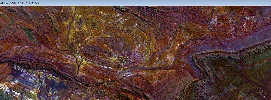

28 Paraburdoo area 8642 image


29 AIG Remote Sensing Seminar - March 2014


30 AIG Remote Sensing Seminar - March 2014
31 SLIP Portal (www2.landgate.wa.gov.au) free vector data can be downloaded Public datasets listed on web site WFS and WMS data integrates with MapInfo (?ArcView) Cadastral data (Landgate) Roads (MRWA) Geology and tenements (Mines Dept) AIG Remote Sensing Seminar - March 2014


32 AIG Remote Sensing Seminar - March 2014


33 AIG Remote Sensing Seminar - March 2014
34 New Landgate service Fully integrated with Google Earth Can run on PC, laptop or tablet Cadastral data Aerial Photography Services (sewerage, water, etc) Mining and Resources information Census (2011) data AIG Remote Sensing Seminar - March 2014


35 AIG Remote Sensing Seminar - March 2014


36 AIG Remote Sensing Seminar - March 2014
37 Property Information Imagery (incl aerial photography) Historic Maps Boundaries Places Health Emergency Services Transport Mining and Resources 2011 Census Utilities AIG Remote Sensing Seminar - March 2014


38 AIG Remote Sensing Seminar - March 2014


39 AIG Remote Sensing Seminar - March 2014
40 Landsat 8 Data free and easy to use Pansharpen with Band 8 gives 15 m resolution suitable for 1: mapping Ability to select date/season to suit application Processing can be done on geo s PC to suit Experiment with band combinations Not rocket science! Landgate Data SLIP data on-line integration with GIS Locate data - integrated with Google Earth AIG Remote Sensing Seminar - March 2014
41 Thank you for your attention Any Questions? AIG Remote Sensing Seminar - March 2014
Landsat 8 Pansharpen and Mosaic Geomatica 2015 Tutorial
 Landsat 8 Pansharpen and Mosaic Geomatica 2015 Tutorial On February 11, 2013, Landsat 8 was launched adding to the constellation of Earth imaging satellites. It is the seventh satellite to reach orbit
29 th Annual Louisiana RS/GIS Workshop April 23, 2013 Cajundome Convention Center Lafayette, Louisiana
 Landsat Data Continuity Mission 29 th Annual Louisiana RS/GIS Workshop April 23, 2013 Cajundome Convention Center Lafayette, Louisiana http://landsat.usgs.gov/index.php# Landsat 5 Sets Guinness World Record
Landsat 8. Snabba leveranser av bilder till användarna. Lars-Åke Edgardh. tisdag 9 april 13
 Landsat 8 Snabba leveranser av bilder till användarna Lars-Åke Edgardh Keystone A single system for: Many sensors Many types of clients Hides the complexity of sensors. Specialised on: Services High volume
Downloading and formatting remote sensing imagery using GLOVIS
 Downloading and formatting remote sensing imagery using GLOVIS Students will become familiarized with the characteristics of LandSat, Aerial Photos, and ASTER medium resolution imagery through the USGS
CanImage. (Landsat 7 Orthoimages at the 1: Scale) Standards and Specifications Edition 1.0
 Standards and Specifications Edition 1.0") CanImage (Landsat 7 Orthoimages at the 1:50 000 Scale) Standards and Specifications Edition 1.0 Centre for Topographic Information Customer Support Group 2144 King Street West, Suite 010 Sherbrooke, QC
CanImage (Landsat 7 Orthoimages at the 1:50 000 Scale) Standards and Specifications Edition 1.0 Centre for Topographic Information Customer Support Group 2144 King Street West, Suite 010 Sherbrooke, QC
Remote Sensing in an
 Chapter 8. Downloading Landsat Imagery using Earth Explorer Remote Sensing in an ArcMap Environment Remote Sensing Analysis in an ArcMap Environment Tammy E. Parece Image source: landsat.usgs.gov Tammy
Lesson 3: Working with Landsat Data
 Lesson 3: Working with Landsat Data Lesson Description The Landsat Program is the longest-running and most extensive collection of satellite imagery for Earth. These datasets are global in scale, continuously
Standing Up NAIP and Landsat Image Services as a Processing Resource. Andrew Leason
 Standing Up NAIP and Landsat Image Services as a Processing Resource Andrew Leason NAIP and Landsat services Differences Different general uses - Landsat - Available from USGS - Designed as an analytical
Using Freely Available. Remote Sensing to Create a More Powerful GIS
 Using Freely Available Government Data and Remote Sensing to Create a More Powerful GIS All rights reserved. ENVI, E3De, IAS, and IDL are trademarks of Exelis, Inc. All other marks are the property of
White Paper. Medium Resolution Images and Clutter From Landsat 7 Sources. Pierre Missud
 White Paper Medium Resolution Images and Clutter From Landsat 7 Sources Pierre Missud Medium Resolution Images and Clutter From Landsat7 Sources Page 2 of 5 Introduction Space technologies have long been
Please show the instructor your downloaded index files and orthoimages.
 Student Exercise 1: Sandia Forest Infestation Acquiring Orthophotos and Satellite Imagery Please show the instructor your downloaded index files and orthoimages. Objectives: Determine appropriate imagery
Remote Sensing. The following figure is grey scale display of SPOT Panchromatic without stretching.
 Remote Sensing Objectives This unit will briefly explain display of remote sensing image, geometric correction, spatial enhancement, spectral enhancement and classification of remote sensing image. At
Downloading Imagery & LIDAR
 Downloading Imagery & LIDAR 333 Earth Explorer The USGS is a great source for downloading many different GIS data products for the entire US and Canada and much of the world. Below are instructions for
Lab 1 Introduction to ENVI
 Remote sensing for agricultural applications: principles and methods (2013-2014) Instructor: Prof. Tao Cheng (tcheng@njau.edu.cn) Nanjing Agricultural University Lab 1 Introduction to ENVI April 1 st,
TEMPORAL ANALYSIS OF MULTI EPOCH LANDSAT GEOCOVER IMAGES IN ZONGULDAK TESTFIELD
 TEMPORAL ANALYSIS OF MULTI EPOCH LANDSAT GEOCOVER IMAGES IN ZONGULDAK TESTFIELD Şahin, H. a*, Oruç, M. a, Büyüksalih, G. a a Zonguldak Karaelmas University, Zonguldak, Turkey - (sahin@karaelmas.edu.tr,
Lecture 6: Multispectral Earth Resource Satellites. The University at Albany Fall 2018 Geography and Planning
 Lecture 6: Multispectral Earth Resource Satellites The University at Albany Fall 2018 Geography and Planning Outline SPOT program and other moderate resolution systems High resolution satellite systems
Laboratory Exercise 1
 Page 1 Laboratory Exercise 1 GEOG*2420 The Earth From Space University of Guelph, Department of Geography Prof. John Lindsay Fall 2013 Total of 32 marks Learning objectives The intention of this lab exercise
Remote sensing in archaeology from optical to lidar. Krištof Oštir ModeLTER Scientific Research Centre of the Slovenian Academy of Sciences and Arts
 Remote sensing in archaeology from optical to lidar Krištof Oštir ModeLTER Scientific Research Centre of the Slovenian Academy of Sciences and Arts Introduction Optical remote sensing Systems Search for
RGB colours: Display onscreen = RGB
 RGB colours: http://www.colorspire.com/rgb-color-wheel/ Display onscreen = RGB DIGITAL DATA and DISPLAY Myth: Most satellite images are not photos Photographs are also 'images', but digital images are
Satellite Imagery and Remote Sensing. DeeDee Whitaker SW Guilford High EES & Chemistry
 Satellite Imagery and Remote Sensing DeeDee Whitaker SW Guilford High EES & Chemistry whitakd@gcsnc.com Outline What is remote sensing? How does remote sensing work? What role does the electromagnetic
HYPERSPECTRAL IMAGERY FOR SAFEGUARDS APPLICATIONS. International Atomic Energy Agency, Vienna, Austria
 HYPERSPECTRAL IMAGERY FOR SAFEGUARDS APPLICATIONS G. A. Borstad 1, Leslie N. Brown 1, Q.S. Bob Truong 2, R. Kelley, 3 G. Healey, 3 J.-P. Paquette, 3 K. Staenz 4, and R. Neville 4 1 Borstad Associates Ltd.,
MAPS AND SATELLITE IMAGES TOOLS FOR AN EFFECTIVE MANAGEMENT OF THE HISTORIC CENTER OF SIGHISOARA, AN UNESCO WORLD HERITAGE SITE
 Journal of Young Scientist, Volume VI, 2018 ISSN 2344-1283; ISSN CD-ROM 2344-1291; ISSN Online 2344-1305; ISSN-L 2344 1283 MAPS AND SATELLITE IMAGES TOOLS FOR AN EFFECTIVE MANAGEMENT OF THE HISTORIC CENTER
Update on Landsat Program and Landsat Data Continuity Mission
 Update on Landsat Program and Landsat Data Continuity Mission Dr. Jeffrey Masek LDCM Deputy Project Scientist NASA GSFC, Code 923 November 21, 2002 Draft LDCM Implementation Phase RFP Overview Page 1 Celebrate!
Lecture 13: Remotely Sensed Geospatial Data
 Lecture 13: Remotely Sensed Geospatial Data A. The Electromagnetic Spectrum: The electromagnetic spectrum (Figure 1) indicates the different forms of radiation (or simply stated light) emitted by nature.
Using Multi-spectral Imagery in MapInfo Pro Advanced
 Using Multi-spectral Imagery in MapInfo Pro Advanced MapInfo Pro Advanced Tom Probert, Global Product Manager MapInfo Pro Advanced: Intuitive interface for using multi-spectral / hyper-spectral imagery
Satellite Remote Sensing: Earth System Observations
 Satellite Remote Sensing: Earth System Observations Land surface Water Atmosphere Climate Ecosystems 1 EOS (Earth Observing System) Develop an understanding of the total Earth system, and the effects of
Geometric Validation of Hyperion Data at Coleambally Irrigation Area
 Geometric Validation of Hyperion Data at Coleambally Irrigation Area Tim McVicar, Tom Van Niel, David Jupp CSIRO, Australia Jay Pearlman, and Pamela Barry TRW, USA Background RICE SOYBEANS The Coleambally
Fusion of Heterogeneous Multisensor Data
 Fusion of Heterogeneous Multisensor Data Karsten Schulz, Antje Thiele, Ulrich Thoennessen and Erich Cadario Research Institute for Optronics and Pattern Recognition Gutleuthausstrasse 1 D 76275 Ettlingen
Spatial Analyst is an extension in ArcGIS specially designed for working with raster data.
 Spatial Analyst is an extension in ArcGIS specially designed for working with raster data. 1 Do you remember the difference between vector and raster data in GIS? 2 In Lesson 2 you learned about the difference
Image interpretation and analysis
 Image interpretation and analysis Grundlagen Fernerkundung, Geo 123.1, FS 2014 Lecture 7a Rogier de Jong Michael Schaepman Why are snow, foam, and clouds white? Why are snow, foam, and clouds white? Today
How to Access Imagery and Carry Out Remote Sensing Analysis Using Landsat Data in a Browser
 How to Access Imagery and Carry Out Remote Sensing Analysis Using Landsat Data in a Browser Including Introduction to Remote Sensing Concepts Based on: igett Remote Sensing Concept Modules and GeoTech
Assessment of Spatiotemporal Changes in Vegetation Cover using NDVI in The Dangs District, Gujarat
 Assessment of Spatiotemporal Changes in Vegetation Cover using NDVI in The Dangs District, Gujarat Using SAGA GIS and Quantum GIS Tutorial ID: IGET_CT_003 This tutorial has been developed by BVIEER as
2017 REMOTE SENSING EVENT TRAINING STRATEGIES 2016 SCIENCE OLYMPIAD COACHING ACADEMY CENTERVILLE, OH
 2017 REMOTE SENSING EVENT TRAINING STRATEGIES 2016 SCIENCE OLYMPIAD COACHING ACADEMY CENTERVILLE, OH This presentation was prepared using draft rules. There may be some changes in the final copy of the
Image Fusion. Pan Sharpening. Pan Sharpening. Pan Sharpening: ENVI. Multi-spectral and PAN. Magsud Mehdiyev Geoinfomatics Center, AIT
 1 Image Fusion Sensor Merging Magsud Mehdiyev Geoinfomatics Center, AIT Image Fusion is a combination of two or more different images to form a new image by using certain algorithms. ( Pohl et al 1998)
Urban Classification of Metro Manila for Seismic Risk Assessment using Satellite Images
 Urban Classification of Metro Manila for Seismic Risk Assessment using Satellite Images Fumio YAMAZAKI/ yamazaki@edm.bosai.go.jp Hajime MITOMI/ mitomi@edm.bosai.go.jp Yalkun YUSUF/ yalkun@edm.bosai.go.jp
Remote Sensing Platforms
 Types of Platforms Lighter-than-air Remote Sensing Platforms Free floating balloons Restricted by atmospheric conditions Used to acquire meteorological/atmospheric data Blimps/dirigibles Major role - news
Can Satellite Image Analysis Replace Manual Digitization?
 Can Satellite Image Analysis Replace Manual Digitization? GeoDATA London 30 th Nov 2017 LUCY KENNEDY Spottitt CEO Lucy.Kennedy@spottitt.com +44 772 594 4643 Agenda Why develop processes and services based
Monitoring of Mosul Reservoir Using Remote Sensing Techniques For the Period After ISIS Attack in 9 June Muthanna Mohammed Abdulhameed AL Bayati
 For the Period After ISIS Attack in 9 June 2014 Lecture: University of Technology Baghdad- Building and Construction Dept 1- Introduction The Mosul Dam is the fourth largest dam in the Middle East,(1)established
Preparing Remote Sensing Data for Natural Resources Mapping (image enhancement, rectifications )
") Preparing Remote Sensing Data for Natural Resources Mapping (image enhancement, rectifications ) Why is this important What are the major approaches Examples of digital image enhancement Follow up exercises
Preparing Remote Sensing Data for Natural Resources Mapping (image enhancement, rectifications ) Why is this important What are the major approaches Examples of digital image enhancement Follow up exercises
Contents Remote Sensing for Studying Earth Surface and Changes
 Contents Remote Sensing for Studying Earth Surface and Changes Anupma Prakash Day : Tuesday Date : September 26, 2008 Audience : AMIDST Participants What is remote sensing? How does remote sensing work?
Practical Uses of Satellite Data in Forest Management
 Practical Uses of Satellite Data in Forest Management GCFF Conference April 2018 Copernicus: Sentinel-2 The Optical Imaging Mission for Land Services 1 Uses for Satellite Imagery 1. Introduction 2. Satellite
PLANET: IMAGING THE EARTH EVERY DAY
 PLANET: IMAGING THE EARTH EVERY DAY Benjamin Trigona-Harany Mailiao Refinery, Taiwan May 31, 2016 To image the whole world every day, making change visible, accessible and actionable. HONG KONG January
ASTER GDEM Readme File ASTER GDEM Version 1
 I. Introduction ASTER GDEM Readme File ASTER GDEM Version 1 The Advanced Spaceborne Thermal Emission and Reflection Radiometer (ASTER) Global Digital Elevation Model (GDEM) was developed jointly by the
Using Soil Productivity to Assess Agricultural Land Values in North Dakota
 Using Soil Productivity to Assess Agricultural Land Values in North Dakota STUDENT HANDOUT Overview Why is assigning a true and full value to agricultural land parcels important? Agricultural production
Remote Sensing for Rangeland Applications
 Remote Sensing for Rangeland Applications Jay Angerer Ecological Training June 16, 2012 Remote Sensing The term "remote sensing," first used in the United States in the 1950s by Ms. Evelyn Pruitt of the
APCAS/10/21 April 2010 ASIA AND PACIFIC COMMISSION ON AGRICULTURAL STATISTICS TWENTY-THIRD SESSION. Siem Reap, Cambodia, April 2010
 APCAS/10/21 April 2010 Agenda Item 8 ASIA AND PACIFIC COMMISSION ON AGRICULTURAL STATISTICS TWENTY-THIRD SESSION Siem Reap, Cambodia, 26-30 April 2010 The Use of Remote Sensing for Area Estimation by Robert
Abstract Quickbird Vs Aerial photos in identifying man-made objects
 Abstract Quickbird Vs Aerial s in identifying man-made objects Abdullah Mah abdullah.mah@aramco.com Remote Sensing Group, emap Division Integrated Solutions Services Department (ISSD) Saudi Aramco, Dhahran
Leica ADS80 - Digital Airborne Imaging Solution NAIP, Salt Lake City 4 December 2008
 Luzern, Switzerland, acquired at 5 cm GSD, 2008. Leica ADS80 - Digital Airborne Imaging Solution NAIP, Salt Lake City 4 December 2008 Shawn Slade, Doug Flint and Ruedi Wagner Leica Geosystems AG, Airborne
Managing Imagery and Raster Data. Peter Becker
 Managing Imagery and Raster Data Peter Becker ArcGIS is a Comprehensive Imagery Platform Empowering you to make informed decisions System of Engagement System of Insight Extract Information from Imagery
Monitoring agricultural plantations with remote sensing imagery
 MPRA Munich Personal RePEc Archive Monitoring agricultural plantations with remote sensing imagery Camelia Slave and Anca Rotman University of Agronomic Sciences and Veterinary Medicine - Bucharest Romania,
Application of GIS to Fast Track Planning and Monitoring of Development Agenda
 Application of GIS to Fast Track Planning and Monitoring of Development Agenda Radiometric, Atmospheric & Geometric Preprocessing of Optical Remote Sensing 13 17 June 2018 Outline 1. Why pre-process remotely
Remote Sensing Techniques
 1 of 8 7/9/2009 12:18 PM Remote Sensing Techniques Table of Contents Remote sensing basics Aerial photography Manned-space photography Landsat satellite imagery Remote Sensing Basics Remote sensing is
Land Cover Analysis to Determine Areas of Clear-cut and Forest Cover in Olney, Montana. Geob 373 Remote Sensing. Dr Andreas Varhola, Kathry De Rego
 1 Land Cover Analysis to Determine Areas of Clear-cut and Forest Cover in Olney, Montana Geob 373 Remote Sensing Dr Andreas Varhola, Kathry De Rego Zhu an Lim (14292149) L2B 17 Apr 2016 2 Abstract Montana
Module 3 Introduction to GIS. Lecture 8 GIS data acquisition
 Module 3 Introduction to GIS Lecture 8 GIS data acquisition GIS workflow Data acquisition (geospatial data input) GPS Remote sensing (satellites, UAV s) LiDAR Digitized maps Attribute Data Management Data
Potential of ASTER and LANDSAT Images for Mapping Features in Western Desert
 522 Potential of ASTER and LANDSAT Images for Mapping Features in Western Desert Mahmoud El Nokrashy Osman Ali, Ibrahim Fathy Mohamed Shaker, Nasr Mohammady Saba Abstract: In Egypt, most of the topographic
Google Earth Engine Image Pre-processing Tool: User guide
 Google Earth Engine Image Pre-processing Tool: Lukas Würsch, Kaspar Hurni, and Andreas Heinimann Centre for Development and Environment (CDE) University of Bern 2017 Introduction The image pre-processing
An Introduction to Remote Sensing & GIS. Introduction
 An Introduction to Remote Sensing & GIS Introduction Remote sensing is the measurement of object properties on Earth s surface using data acquired from aircraft and satellites. It attempts to measure something
Remote sensing image correction
 Remote sensing image correction Introductory readings remote sensing http://www.microimages.com/documentation/tutorials/introrse.pdf 1 Preprocessing Digital Image Processing of satellite images can be
Lineament Extraction using Landsat 8 (OLI) in Gedo, Somalia
 in Gedo, Somalia") Lineament Extraction using Landsat 8 (OLI) in Gedo, Somalia Umikaltuma Ibrahim 1, Felix Mutua 2 1 Jomo Kenyatta University of Agriculture & Technology, Department of Geomatic Eng. & Geospatial Information
Lineament Extraction using Landsat 8 (OLI) in Gedo, Somalia Umikaltuma Ibrahim 1, Felix Mutua 2 1 Jomo Kenyatta University of Agriculture & Technology, Department of Geomatic Eng. & Geospatial Information
NON-PHOTOGRAPHIC SYSTEMS: Multispectral Scanners Medium and coarse resolution sensor comparisons: Landsat, SPOT, AVHRR and MODIS
 NON-PHOTOGRAPHIC SYSTEMS: Multispectral Scanners Medium and coarse resolution sensor comparisons: Landsat, SPOT, AVHRR and MODIS CLASSIFICATION OF NONPHOTOGRAPHIC REMOTE SENSORS PASSIVE ACTIVE DIGITAL
Satellite Monitoring of a Large Tailings Storage Facility
 Satellite Monitoring of a Large Tailings Storage Facility Benjamin Schmidt and Matt Malgesini, Golder Associates Inc., USA Jim Turner, PhotoSat Ltd, Canada Jeff Reinson, Goldcorp Inc., Canada Presentation
Geomatica OrthoEngine Orthorectifying SPOT6 data
 Geomatica OrthoEngine Orthorectifying SPOT6 data On September 9, 2012, SPOT 6 was launched adding to the constellation of Earthimaging satellites designed to provide 1.5m high-resolution data. The architecture
USGS Welcome. 38 th CEOS Working Group on Calibration and Validation Plenary (WGCV-38)
") Landsat 5 USGS Welcome Prepared for 38 th CEOS Working Group on Calibration and Validation Plenary (WGCV-38) Presenter Tom Cecere International Liaison USGS Land Remote Sensing Program Elephant Butte Reservoir
Landsat 5 USGS Welcome Prepared for 38 th CEOS Working Group on Calibration and Validation Plenary (WGCV-38) Presenter Tom Cecere International Liaison USGS Land Remote Sensing Program Elephant Butte Reservoir
to Geospatial Technologies
 What s in a Pixel? A Primer for Remote Sensing What s in a Pixel Development UNH Cooperative Extension Geospatial Technologies Training Center Shane Bradt UConn Cooperative Extension Geospatial Technology
NORMALIZING ASTER DATA USING MODIS PRODUCTS FOR LAND COVER CLASSIFICATION
 NORMALIZING ASTER DATA USING MODIS PRODUCTS FOR LAND COVER CLASSIFICATION F. Gao a, b, *, J. G. Masek a a Biospheric Sciences Branch, NASA Goddard Space Flight Center, Greenbelt, MD 20771, USA b Earth
REMOTE SENSING FOR FLOOD HAZARD STUDIES.
 REMOTE SENSING FOR FLOOD HAZARD STUDIES. OPTICAL SENSORS. 1 DRS. NANETTE C. KINGMA 1 Optical Remote Sensing for flood hazard studies. 2 2 Floods & use of remote sensing. Floods often leaves its imprint
LAND SURFACE TEMPERATURE MONITORING THROUGH GIS TECHNOLOGY USING SATELLITE LANDSAT IMAGES
 Abstract LAND SURFACE TEMPERATURE MONITORING THROUGH GIS TECHNOLOGY USING SATELLITE LANDSAT IMAGES Aurelian Stelian HILA, Zoltán FERENCZ, Sorin Mihai CIMPEANU University of Agronomic Sciences and Veterinary
Introduction to Remote Sensing
 Introduction to Remote Sensing Spatial, spectral, temporal resolutions Image display alternatives Vegetation Indices Image classifications Image change detections Accuracy assessment Satellites & Air-Photos
IceTrendr - Polygon. 1 contact: Peder Nelson Anne Nolin Polygon Attribution Instructions
 INTRODUCTION We want to describe the process that caused a change on the landscape (in the entire area of the polygon outlined in red in the KML on Google Earth), and we want to record as much as possible
Unsupervised Classification
 Unsupervised Classification Using SAGA Tutorial ID: IGET_RS_007 This tutorial has been developed by BVIEER as part of the IGET web portal intended to provide easy access to geospatial education. This tutorial
The first part of Module three, data and tools, presents some of the resources available on the internet to get images from the satellites presented
 The first part of Module three, data and tools, presents some of the resources available on the internet to get images from the satellites presented in the previous module and some uses of the images,
Important Missions. weather forecasting and monitoring communication navigation military earth resource observation LANDSAT SEASAT SPOT IRS
 Fundamentals of Remote Sensing Pranjit Kr. Sarma, Ph.D. Assistant Professor Department of Geography Mangaldai College Email: prangis@gmail.com Ph. No +91 94357 04398 Remote Sensing Remote sensing is defined
What is Photogrammetry
 Photogrammetry What is Photogrammetry Photogrammetry is the art and science of making accurate measurements by means of aerial photography: Analog photogrammetry (using films: hard-copy photos) Digital
Remote Sensing Platforms
 Remote Sensing Platforms Remote Sensing Platforms - Introduction Allow observer and/or sensor to be above the target/phenomena of interest Two primary categories Aircraft Spacecraft Each type offers different
Lecture Series SGL 308: Introduction to Geological Mapping Lecture 8 LECTURE 8 REMOTE SENSING METHODS: THE USE AND INTERPRETATION OF SATELLITE IMAGES
 LECTURE 8 REMOTE SENSING METHODS: THE USE AND INTERPRETATION OF SATELLITE IMAGES LECTURE OUTLINE Page 8.0 Introduction 114 8.1 Objectives 115 115 8.2 Remote Sensing: Method of Operation 8.3 Importance
Porta Farm Image Analysis. Summary. May 14, Lars Bromley, Summary... 1 Location... 4 Imagery... 4 Processing and Analysis...
 Porta Farm Image Analysis May 14, 2006 Lars Bromley, lbromley@aaas.org Summary... 1 Location... 4 Imagery... 4 Processing and Analysis...5 Summary According to Amnesty International the legal settlement
Lab 3: Introduction to Image Analysis with ArcGIS 10
 Lab 3: Introduction to Image Analysis with ArcGIS 10 Peter E. Price TerraView 2010 Peter E. Price All rights reserved. Revised 03/2011. Revised for Geob 373 by BK Feb 7, 2017. V9 The information contained
NASA Missions and Products: Update. Garik Gutman, LCLUC Program Manager NASA Headquarters Washington, DC
 NASA Missions and Products: Update Garik Gutman, LCLUC Program Manager NASA Headquarters Washington, DC 1 JPSS-2 (NOAA) SLI-TBD Formulation in 2015 RBI OMPS-Limb [[TSIS-2]] [[TCTE]] Land Monitoring at
USING MULTISPECTRAL SATELLITE IMAGES FOR UP-DATING VECTOR DATA IN A GEODATABASE
 JOURNAL OF APPLIED ENGINEERING SCIENCES VOL. 1(14), issue 4_2011 ISSN 2247-3769 ISSN-L 2247-3769 (Print) / e-issn:2284-7197 USING MULTISPECTRAL SATELLITE IMAGES FOR VAIS Manuel Bucharest University, e-mail:
GEOG432: Remote sensing Lab 3 Unsupervised classification
 GEOG432: Remote sensing Lab 3 Unsupervised classification Goal: This lab involves identifying land cover types by using agorithms to identify pixels with similar Digital Numbers (DN) and spectral signatures
Aral Sea profile Selection of area 24 February April May 1998
 250 km Aral Sea profile 1960 1960 1985 1986 1987 1988 1989 1990 1991 1992 1993 1994 1995 1996 1997 1998 2010? Selection of area Area of interest Kzyl-Orda Dried seabed 185 km Syrdarya river Aral Sea Salt
Online Resources: KEY FEATURES
 Explore key features of online Earth science data tools that can be useful for K 12 student investigations. Sources are color coded for relative level/ease-of-use: BLUE (introductory); ORANGE (intermediate)
1. Theory of remote sensing and spectrum
 1. Theory of remote sensing and spectrum 7 August 2014 ONUMA Takumi Outline of Presentation Electromagnetic wave and wavelength Sensor type Spectrum Spatial resolution Spectral resolution Mineral mapping
INTRODUCTORY REMOTE SENSING. Geob 373
 INTRODUCTORY REMOTE SENSING Geob 373 Landsat 7 15 m image highlighting the geology of Oman http://www.satimagingcorp.com/gallery-landsat.html ASTER 15 m SWIR image, Escondida Mine, Chile http://www.satimagingcorp.com/satellite-sensors/aster.html
Sources of Geographic Information
 Sources of Geographic Information Data properties: Spatial data, i.e. data that are associated with geographic locations Data format: digital (analog data for traditional paper maps) Data Inputs: sampled
Satellite monitoring of a large tailings storage facility
 ABSTRACT Satellite monitoring of a large tailings storage facility Benjamin Schmidt, Matt Malgesini Golder Associates Inc., USA Jim Turner PhotoSat Ltd, Canada Jeff Reinson Goldcorp Inc., Canada Minera
Sommersemester Prof. Dr. Christoph Kleinn Institut für Waldinventur und Waldwachstum Arbeitsbereich Fernerkundung und Waldinventur.
 Basics of Remote Sensing Some literature references Franklin, SE 2001 Remote Sensing for Sustainable Forest Management Lewis Publishers 407p Lillesand, Kiefer 2000 Remote Sensing and Image Interpretation
LANDSAT 8 Level 1 Product Performance
 Réf: IDEAS-TN-10-CyclicReport LANDSAT 8 Level 1 Product Performance Cyclic Report Month/Year: May 2015 Date: 25/05/2015 Issue/Rev:1/0 1. Scope of this document On May 30, 2013, data from the Landsat 8
Viewing Landsat TM images with Adobe Photoshop
 Viewing Landsat TM images with Adobe Photoshop Reformatting images into GeoTIFF format Of the several formats in which Landsat TM data are available, only a few formats (primarily TIFF or GeoTIFF) can
Environmental Remote Sensing GEOG 2021
 Environmental Remote Sensing GEOG 2021 Lecture 2 Image display and enhancement 2 Image Display and Enhancement Purpose visual enhancement to aid interpretation enhancement for improvement of information
The (False) Color World
 Color World") There s more to the world than meets the eye In this activity, your group will explore: The Value of False Color Images Different Types of Color Images The Use of Contextual Clues for Feature Identification
There s more to the world than meets the eye In this activity, your group will explore: The Value of False Color Images Different Types of Color Images The Use of Contextual Clues for Feature Identification
INTEGRATION OF MULTITEMPORAL ERS SAR AND LANDSAT TM DATA FOR SOIL MOISTURE ASSESSMENT
 INTEGRATION OF MULTITEMPORAL ERS SAR AND LANDSAT TM DATA FOR SOIL MOISTURE ASSESSMENT Beata HEJMANOWSKA, Stanisław MULARZ University of Mining and Metallurgy, Krakow, Poland Department of Photogrammetry
Appendix 2: Worked example using GPS
 Appendix 2: Worked example using GPS This appendix will talk the reader through how to use a GPS, get data out of the unit and use that data in the expedition GIS. The specific example used is a simple
MRLC 2001 IMAGE PREPROCESSING PROCEDURE
 MRLC 2001 IMAGE PREPROCESSING PROCEDURE The core dataset of the MRLC 2001 database consists of Landsat 7 ETM+ images. Image selection is based on vegetation greenness profiles defined by a multi-year normalized
EE/GP140-The Earth From Space- Winter 2008 Handout #16 Lab Exercise #3
 EE/GP140-The Earth From Space- Winter 2008 Handout #16 Lab Exercise #3 Topic 1: Color Combination. We will see how all colors can be produced by combining red, green, and blue in different proportions.
Satellite image classification
 Satellite image classification EG2234 Earth Observation Image Classification Exercise 29 November & 6 December 2007 Introduction to the practical This practical, which runs over two weeks, is concerned
Lecture 2. Electromagnetic radiation principles. Units, image resolutions.
 NRMT 2270, Photogrammetry/Remote Sensing Lecture 2 Electromagnetic radiation principles. Units, image resolutions. Tomislav Sapic GIS Technologist Faculty of Natural Resources Management Lakehead University
The studies began when the Tiros satellites (1960) provided man s first synoptic view of the Earth s weather systems.
 provided man s first synoptic view of the Earth s weather systems.") Remote sensing of the Earth from orbital altitudes was recognized in the mid-1960 s as a potential technique for obtaining information important for the effective use and conservation of natural resources.
Remote sensing of the Earth from orbital altitudes was recognized in the mid-1960 s as a potential technique for obtaining information important for the effective use and conservation of natural resources.
Data Requirements Definition and Data Services Options for RAPP
 Data Requirements Definition and Data Services Options for RAPP Brian Killough CEOS Systems Engineering Office (SEO) 5 th GEOGLAM RAPP Workshop Frascati, Italy May 16-17, 2017 Requirements Update The observation
ANNEX IV ERDAS IMAGINE OPERATION MANUAL
 ANNEX IV ERDAS IMAGINE OPERATION MANUAL Table of Contents 1. TOPIC 1 DATA IMPORT...1 1.1. Importing SPOT DATA directly from CDROM... 1 1.2. Importing SPOT (Panchromatic) using GENERIC BINARY... 7 1.3.