AUVs A View of the Autonomous Underwater Vehicle Market
|
|
|
- David Montgomery
- 5 years ago
- Views:
Transcription

1 APRIL 2013 > VOLUME 17 > NUMBER 3 > AUVs A View of the Autonomous Underwater Vehicle Market Balancing Old and New Roles Key to Hydrography Hydro INTERNATIONAL Interviews Evert Flier More Variety at an Expanded Trade Show Ocean Business Preview


2 The TELEDYNE RESON name is the hallmark of class leading Sonar equipment, Transducers, Hydrophones, and Survey software that you can count on. Headquartered in Denmark, TELEDYNE RESON has a global presence with offices and representatives around the world. Meet us at Ocean Business 2013, BOOTH L15 or join us in one of our live Boat Demonstrations. We will be demonstrating our very latest 2013 year model SeaBat multibeam system, Feature Packs and PDS2000 survey data acquisition, processing and visualization software. No. 3303


3 Contents Ocean Business Preview 33 More Variety at an Expanded Trade Show Editorial 5 News 7 Interview 10 Evert Flier Man-made Sound and Marine Life 25 Measuring the Potential Acoustic Impact of Marine Renewables Development Letter to the Editor 31 IHO 47 Global Geospatial Information Management and Marine Spatial Data Infrastructures History 48 First Command Business 52 Meritaito Products 54 AUVs 14 A View of the Autonomous Underwater Vehicle Market Organisations 56 Western Signalling Service From the National Societies 58 Australasian Hydrographic Society Hydrographic Society Benelux Hydrographic Society Russia IENCs in Flanders 19 Electronic Navigational Charts Produced by Flemish Hydrography Agenda 61 List of Advertisers 61 Insider s View 62 Mark Sinclair APRIL 2013 VOLUME17 > NUMBER3 A Bluefin 21 AUV being deployed. Read more about AUVs, their applications and the markets in the feature article by Ioseba Tena, from page 14. For specifications of AUVs, see the product category AUVs on Hydro INTERNATIONAL APRIL


4 Ekinox INS TACTICAL GRADE MEMS Inertial Navigation System BRINGS COST-EFFECTIVE MEMS TO FOG S ACCURACY» 0.05 Attitude, 2 cm GNSS Position» NMEA, Ethernet & Web interface» 5 cm Heave on 4 monitoring points DVL, LBL, USBL, GPS/GNSS, EM Log French Pavilion Booth T5 No WORLD CLASS Through People, Technology & Dedication For more information about our products, please contact us at No 3201

5 Hydro INTERNATIONAL is an independent international magazine published 8 times a year by Geomares Publishing. The magazine and related e-newsletter inform worldwide professional, industrial and governmental readers of the latest news and developments in the hydrographic, surveying, marine cartographic and geomatics world. Hydro INTERNATIONAL encompasses all aspects, activities and equipment related to the acquisition, processing, presentation, control and management of hydrographic and surveying-related activities. PHOTOGRAPHY: ARIE BRUINSMA ( Spring Publishing Company: Geomares Publishing P.O. Box 112, 8530 AC Lemmer, The Netherlands Phone: +31 (0) , Fax: +31 (0) info@geomares.nl No material may be reproduced in whole or in part without written permission from Geomares Publishing Copyright 2013, Geomares Publishing, The Netherlands All rights reserved. ISSN Publishing Director: Durk Haarsma Financial Director: Meine van der Bijl Technical Editor: Mark Pronk, BSc Contributing Editors: RADM Giuseppe Angrisano (retd) of the Italian Navy, Dr. ir. Leendert Dorst, Andrew Gerrard, MSc, Dr Ronald Koomans, Capt. Albert Skip Theberge, NOAA Corps (retd) Editorial Board: Cor Beemster, Ir. Sicco Kamminga, Ir. Rob van Ree, Drs. Robert van der Velden Regional Correspondents: Andrew Armstrong (USA), Gary Chisholm (New Zealand), Safaruddin Kamaruddin (Malaysia), Cdr Ayodeji Olugbode (Nigeria), George Schlagintweit (Canada) Editorial Manager: Drs. Joost Boers Copy Editor: Kirsten van Hasselt Account Manager: Herma Lenten Marketing Assistant: Trea Fledderus Circulation Manager: Adrian Holland Design: Verheul Media Supporters BV, Alphen aan den Rijn, Advertisements Information about advertising is available in the media planner on our website or by contacting our account manager (herma.lenten@geomares.nl). Buyers Guide Hydrography is booming survey companies, data specialists, hydrographers, cartographers, oceanographers they are all working hard to get the job done. And they need to invest for an improved handling of their clients requests. Time is scarce that s why Hydro INTERNATIONAL is preparing a Buyer s Guide to facilitate communication between you and your clients. The Buyer s Guide features Company Profiles, Contact Details and an online directory with a categorised overview of suppliers. The Buyer s Guide is distributed among subscribers of Hydro INTERNATIONAL, visitors to international trade shows throughout the year and is available from buyersguide thus it is a valuable information source to consult regularly throughout the year. For further information, please contact herma.lenten@geomares.nl Paid Subscription Hydro INTERNATIONAL is available bi-monthly on a subscription basis. The annual subscription rate for Hydro INTERNATIONAL is 100 within the European Union, and 145 for non-european countries. Subscription can commence at any time, by arrangement via our website or by contacting Abonnementenland, a Dutch subscription administration company. Subscriptions are automatically renewed upon expiry, unless Abonnementenland receives written notification of cancellation at least 60 days before expiry date. Prices and conditions may be subject to change. For multi-year subscription rates or information on current paid subscriptions, contact Abonnementenland, Postbus 20, 1910 AA Uitgeest, Netherlands, +31 (0) , ( hrs, UTC +1) paidsubscription@geomares.nl Editorial Contributions All material submitted to the publisher (Geomares Publishing) and relating to Hydro INTERNATIONAL will be treated as unconditionally assigned for publication under copyright subject to the Editor s unrestricted right to edit and offer editorial comment. Geomares Publishing assumes no responsibility for unsolicited material or for the accuracy of information thus received. Geomares Publishing assumes, in addition, no obligation for return postage of material if not explicitly requested. Contributions must be sent to the editorial manager joost.boers@geomares.nl). Reprints Printed copies of all articles (including those published in ear lier issues) can be ordered. For more information, please contact trea.fledderus@geomares.nl Durk Haarsma durk.haarsma@geomares.nl Spring is always an exciting time for many hydrographers. Not just because it is the start of the good season for surveying (at least in the northern hemisphere where everybody is longing for warmer weather after a long, long winter...), but also because the season of the tradeshows and conferences will be starting. Traditionally, spring has been a time for business-to-business (like the autumn) with new and known techniques being demonstrated to users at shows all over the world. One of the shows that has quickly become a regular fixture on the annual calendar is Ocean Business in Southampton, UK, that will take place from 9 to 11 April in Demonstrations and workshops play a prominent role at Ocean Business and the conference Offshore Survey taking place alongside the exhibition. In other words, it s all about the products. The Hydro International team will of course be attending Ocean Business. It s going to be an exciting spring for Hydro International because we are introducing Geo-matching.com ( for hydrography. Geo-matching.com enables hydrographers to compare products before buying them. The website features detailed spec-based comparisons of more than 500 products and aims to lead you through the maze of specifications and gives you the opportunity to read reviews written by peers. Of course everybody is warmly invited to leave a balanced review of a product! The website brings together all the highly valued Hydro International product surveys, including GNSS receivers, Inertial Navigation Systems, Autonomous Underwater Vehicles, Remotely Operated Vehicles, Side-scan sonar, and Multi-beam echo sounders. In addition to an extensive preview on the new products to be explored at Ocean Business, this issue of Hydro International carries an interesting interview with the director of the Norwegian Hydrographic Service (see page 10). Dutchman Evert Flier has been heading the NHS since 2010 and he pairs challenges of a modern hydrographic service to vision in how to adjust his organisation to these times. This adjusting requires balancing between the different roles of hydrography. On the one hand, of course, the traditional role of servicing the maritime world with accurate charts in order for them to be able to navigate safely. On the other side of the spectrum, the new role of hydrography servicing the blue economy in its broadest sense: oil & gas, fisheries and infrastructure in the coastal zone. A big help is the new standard S-100, according to Flier. The new standard will make it easier to provide data for other purposes. It makes it easy to put other data layers on top of hydrographic data and in doing so S-100 improves opportunities to integrate information, making bathymetric data more widely available and applicable. Indeed, exciting times in which the foundations upon which hydrography will develop further might be built. Hopefully we ll have the opportunity to meet each other in Southampton. If you are not able to come to the UK, we ll keep you up to date with the daily newsletter from the show and conference floor. Hydro International wants to make sure you don t miss a thing this spring! Hydro INTERNATIONAL APRIL


6 No. 3300

 of the British Royal Navy, has recently produced a series")

7 News HPD for Indonesia Indonesian Hydrographic Service DISHID- ROS recently decided to upgrade its production system to the CARIS Hydrographic Production Database (HPD). In addition to HPD, the upgrade provides DISHIDROS with a complete and seamless ping-to-chart solution, including CARIS HIPS and SIPS for the processing of hydrographic data and CARIS Bathy DataBASE for the management and analysis of elevation data sources. Royal Navy Ship Discovers Uncharted Red Sea Canyon HMS Enterprise, a multi-role survey vessel - hydrographic oceanographic (SVHO) of the British Royal Navy, has recently produced a series of stunning images of a Grand Canyon-style ocean floor hidden deep under the Red Sea. The vessel used her surveying equipment to reveal the natural wonder during her nine-month mission to improve understanding of the waters east of Suez. Image of the Red Sea Canyon. (Image courtesy: UK.gov). Sustainable Management of European Marine And Coastal Areas The European Commission has launched a proposal to improve the planning of maritime activities at sea and the management of coastal areas. The proposal in the form of a draft directive aims to establish a common European framework for maritime spatial planning and integrated coastal management in EU Member States, with a view to ensuring that the growth of maritime and coastal activities and the use of resources at sea and on coasts remain sustainable. Portuguese Continental Shelf Research to Benefit from Alliance Maritime Training & Competence Solutions (MTCS), UK, plans to send a number of its ROV pilot trainees to Portugal to assist EMEPC in its work on the Portuguese continental shelf. In April 2005, the Portuguese government created a multidisciplinary task group for the extension of the continental shelf (EMEPC) to prepare Portugal s claim to the CLCS (Commission on the Limits of the Continental Shelf). Deployment of the ROV Luso. Offshore Division for Coastline Surveys As part of its continued growth, UK-based Coastline Surveys is launching Coastline Offshore, a new division of the company specifically developed to meet the growing demands for specialist offshore geotechnical and geophysical services beyond its established near-shore markets. The division will enable the company to employ its expertise in emerging offshore renewables, at home and abroad, whilst also firmly establishing it as a significant survey support subcontractor within the oil & gas industry. No 3289 Hydro INTERNATIONAL APRIL

8 News Images of WWII D-Day Harbour Revealed The UK Hydrographic Office (UKHO) has released images from a survey of the underwater remains of an artificial harbour used in World War II that was used to facilitate rapid offloading of cargo during the Allied landings in Normandy, France. The images of Mulberry B, which was one of these portable temporary harbours developed and built in total secrecy by the British forces in World War II, have been created from a detailed 3D map that will allow archaeologists to assess the rate of deterioration of the remains. Elements of the WWII Harbour. (Image Courtesy: UKHO). Optimare Joins Aerodata Group Optimare became a member of the German Aerodata Group on 1 March This notable step creates a solution provider for airborne maritime surveillance, combining aircraft conversion, mission systems and a range of own remote sensors from one source. Optimare will carry on with the operation of the airborne surveillance and marine observing systems business as Optimare Systems GmbH. Fugro Closes Seabed Geosolutions Joint Venture Fugro, headquartered in the Netherlands, and France-based CGG, have announced the closure of the previously announced Seabed Geosolutions joint venture on 16 February The closure completes the process of incorporation of the ocean bottom node businesses from Fugro and CGG, and the CGG transition zone, ocean bottom cable and permanent reservoir monitoring activities in a joint venture. Reception at IHO for World Hydrography Day The Directing Committee of the International Hydrography Bureau has proposed Hydrography - Underpinning the Blue Economy as the theme for the celebration of World Hydrography Day 2013 (WHD-2013), to be held on 21 June This theme is intended to raise awareness of the importance and usefulness of hydrography for issues other than safety, and in particular to highlight the economic benefits that governments, industry and the public can obtain by supporting hydrographic programmes at the national level. A reception at the IHO headquarters is one of the activities. First Bay of Islands Survey in 21 Years Discovery Marine (DML, New Zealand) has recently been awarded a contract by Land Information New Zealand (LINZ) to provide a hydrographic survey of the Bay of Islands, New Zealand. The last major surveys of the area, to IHO standards, were undertaken in 1955 and This new survey will get underway in March with deliverables due in June The survey area primarily consists of the coastline and nearshore area of the Bay of Islands between Russell and Opua. The multi-beam hydrographic survey will have a particular emphasis on accurately locating and identifying significant bathymetric features, shoals, reefs and potential dangers to navigation. Italian Hydrographic Society Joins IFHS Following an interim two years as an associate member, the Italian Hydrographic Society (IHS) has been elected a full member of the International Federation of Hydrographic Societies (IFHS) which comprises national organisations in Australasia, Benelux, Denmark, Germany, South Africa and the UK. Subsea Imagery Collaboration Fugro Chance, USA, and Coda Octopus Group (USA) have entered into a co-operation agreement for two years to take advantage of Coda Octopus Echoscope. This relationship will give Coda Octopus early access to real-world requirements associated with Fugro Chance projects. In return, Fugro will have the advantage of working with Coda Octopus to develop tailored solutions for its clients subsea imagery deliverables. 8 APRIL 2013 Hydro INTERNATIONAL

9 Most Shared Most shared during the last month from 1. Stop Using DGPS (Letter to the Editor) Underwater Lidar System Royal Navy Ship Discovers Uncharted Red Sea Canyon Images of WWII D-Day Harbour Revealed Gravity Data Determines Sloping sea Dilemma - MacArtney Partners with Pacific WindFloat Project Renewable energy technology developer Principle Power has been awarded a Department of Energy grant worth USD4 million, and up to USD47 million in total funding, to support its WindFloat Pacific Demonstration Project. In that connection, Principle WindFloat construction site. Power has announced the list of official project partners, all marked to deliver an essential contribution to the WindFloat project. MacArtney Underwater Technology is one of the partners of the large-scale project. Milestone for Dolphin Multi-client Surveys Dolphin Geophysical s 3D seismic vessel, the Polar Duke, will shortly commence acquisition of the remaining UK Quads 29 & 30 SHarp BroadBand High-Resolution 3D Multiclient survey. It is estimated that it will take approximately 5 months to complete the current planned survey coverage which was partially acquired last year. Dolphin s sister vessel, the Polar Duchess, will complete the survey after the Polar Duke leaves the area due to contract work commitments. 52nd Marine Measurement Forum The MacArtney Underwater Technology Group is to host the 52nd Marine Measurement Forum. The event will take place on 1 May 2013 at the MacArtney Group s UK facilities in Aberdeen. The organisers look forward to welcoming speakers and attendees alike to a day devoted to the informal sharing of new knowledge and ideas within the realm of marine scientific measurement. The course of the day will embrace several features and sessions, hereunder a number of presentations on the latest developments within the diverse field of marine measurement technology. Within this context, MacArtney encourages all prospective speakers to apply. For further information about the event, hereunder registration, please visit Tesla Expands Deepwater Survey Business Tesla Offshore, based in Houston, USA, is purchasing a Bluefin-21 AUV from Bluefin Robotics (USA). This purchase coincides with Tesla s intent to expand its presence in deepwater oil and gas field development, as well as positioning itself to pursue governmental, environmental and academic applications support. Tesla Offshore will operate its AUV on a global basis and, specifically, in the Gulf of Mexico where US government regulatory agents are considering proposals that mandate archaeological and shallow hazard survey data be acquired by AUV technologies. Guidance on RADius Relative Positioning System The International Marine Contractors Association (IMCA) has just published Guidance on RADius Relative Positioning System (IMCA M 224) describing the RADius microwave radar system. This document is produced by IMCA as an aid to members and others using position reference systems and forms part of a series of documents on the available systems. In common with some previous documents on position reference systems, it has been prepared in the major part by the manufacturer of the system, in this case Kongsberg Seatex. More news news.php Hydro INTERNATIONAL APRIL

10 Balancing Old and New Roles Key to Hydrography Hydro INTERNATIONAL Interviews Evert Flier Surveying a coastline of 102,000km and sea surface of 2.3 million km 2 to make safe navigation possible in the treacherous fjords of Norway, together with new applications of hydrography for the blue economy, director of the Norwegian Hydrographic Service, Dutchman and naval officer Evert Flier, stands for a challenge that requires balancing with a vision. Flier tells Hydro INTERNATIONAL, amongst other, how he tries to navigate between old and new tasks of the Hydrographic Office. Durk Haarsma Publishing director, Hydro INTERNATIONAL First of all, S-100 is becoming a new standard. What does the Norwegian Hydrographic Service see as the benefits of this standard? The new standard will enable us to make our data available for other purposes more easily. That is a paradigm shift in hydrography. The transition from S-57 to S-100 makes it easy to put other data layers on top of hydrographic data. S-100 improves opportunities to integrate information and therefore make bathymetric data more widely available and applicable. I see a shift towards servicing the whole blue economy instead of just traditional shipping the main purpose of old hydrography - something that is not yet happening everywhere, but something that evidently will happen in the future, also through the new standard. Can you name a few examples of how bathymetric data will be used in the future in Norway? I mentioned the term blue economy which for me encompasses both the maritime sea level activities Even though surveying is costly, there are great benefits for society and the marine society below sea level activities. Besides the obvious fields, such as dredging, oil & gas and offshore wind farms, you will see a growing need for bathymetric data in, for example, environmental research and fish farming. From a navigational point of view, we are 10 APRIL 2013 Hydro INTERNATIONAL
11 interested in the peaks because they can pose a risk to shipping. From an environmental point of view, we might be interested in the valleys because that is where pollution residue accumulates. The big salmon farming industry in Norway needs good bathymetry for sea-current modelling, simply to be able to locate the farm in such a way that faeces are taken away from the living environment by currents. Another example: by law the 285 coastal communities in Norway have recently been given an extended area responsibility of 1 nautical mile out of their coastline. For planning purposes they need reliable hydrographic data. So there are many parties that need our data for sustainable development of the coastal zone. What does this wider use of hydrographic data mean for Hydrographic Services in general, taking budget cuts into account? We see that survey capacity worldwide is decreasing. Surveying with vessels with multi-beam echo sounders is complex, very expensive and time consuming. Budget cuts, because of the economic crisis, make it unlikely that this capacity will increase very soon. On the other hand, there is a report from NOAA that says that the return on investment of bathymetric survey for the entire community is 35. Another report by the Irish Hydrographic Service estimates ROI around 5 to 6. These reports show that even though surveying is costly, there are great benefits for society. We therefore need to convince and organise decisionmakers, not just in politics, but also in industry and business, to step up to the challenge and increase the amount of hydrographic surveying being done, against the odds of economy. And for the Norwegian Hydrographic Service in particular? Norway is very wealthy, but its waters are far from being properly surveyed. For instance, only 26 per cent of our shallow waters, 0 to 20 metres, has been surveyed with modern techniques. At present, it will take us at least 30 years just to cover these shallow areas. We have a long-term vision to see if we can fill the gaps in the shallow areas within 15 to 20 years. The areas for which we are responsible in the Arctic regions is a whole different ball game where we need to think about alternative ways of gathering data. Crowdsourcing or using ships of opportunity might be one of them. Of course we have also been exploring Lidar bathymetry since the late 1990s. We had a huge project from 1998 to 2008, funded by the Norwegian government, to reach full ENC coverage of Norwegian waters. Lidar bathymetry was mainly used in that project for planning purposes to decide where we had to go to survey with MBES. It is good to explore these possibilities, because we have to be realistic in our expectations. If we want multi-beam data quality for all uncharted waters it will take far too long. How difficult is it to set your strategy and aims, taking into account budget constraints combined with a broadened range of users? Strategy sets your direction, budget decides how long you can go. Our strategy is to support the blue economy, on the other hand our ENC portfolio is still growing, which means our efforts to maintain those charts are inevitably increasing as well. We will need to focus on the efficient use of new techniques and co-operation to make all this happen. I think that the two can be combined. A shipping accident will not provide you with extra income, sharing data with other parties that see the added value in hydrographic data will. It could well be that the broadened use of hydrographic data contributes to safer navigation for the traditional shipping industry. The INSPIRE Initiative Europe advocates free spatial data. Although Norway is not in the European Union, it might be influenced by it. What is your view on opening up data to the public? There is no such thing as a free lunch. Either the user pays for it or the entire society pays for it through taxes. Looking at the value creating potential of bathymetric data, I would advocate for free data. A shift towards servicing the whole blue economy instead of just traditional shipping But two-thirds of the Norwegian Hydrographic Service s yearly budget comes from government funding while one-third is from sales of its products. Giving away the data for free will simply require having to make up for lost revenue of that one-third if we are to continue our present activity level. In what ways do you co-operate with the large oil & gas industry in Norway? We have a good co-operation with oil and gas companies, for instance with Statoil, but also with the other big players in the oil & gas industry. They provide us with all the bathymetric data they have gathered before their seismic surveys. These datasets are very helpful. What I would like though is a system that would prevent doubling survey efforts. Nowadays, it is not always clear who is going to survey where and when. Unfortunately, I know of a case where we surveyed the Hardanger Fjord Evert Flier has been director of the Norwegian Hydrographic Service since Before that he served as an Officer in the Royal Netherlands Navy from He held executive positions on several frigates. He was project manager for navigational equipment at the Directorate for Material Royal Netherlands Navy, taught navigation and safety at sea at the Royal Netherlands Naval Academy, served as Commanding Officer on a naval instruction vessel and was staff officer at the Ministry of Defence. He worked as head Internal Training for the NATO Joint Warfare Centre in Stavanger, before joining the Hydrographic Service of Norway as director. He holds a Master s degree in Security and Defence from the Netherlands Defence College and a Bachelor s degree in Information and Technology from the Technical University in Eindhoven, the Netherlands. Hydro INTERNATIONAL APRIL


12 THE NEXT LEVEL OF MEMS AHRS AND GPS/INS The MTi: an extensive product portfolio With 7 products, the 4th generation MTi product portfolio comes into various accuracy levels and various capabilities: from the reliable MTi-10 IMU to the innovative GPS-aided MTi-G-700 GPS/INS. The use of the latest state-of-the-art gyroscopes and excellent signal processing pipeline results in an AHRS that competes with high-grade optical IMU s, even under vibrations and adverse conditions. Xsens is the innovative leader in 3D motion tracking. The MTi technology is the market standard since 12 years and is the preferred choice of the majority of maritime system integrators. Please find more at: Xsens Xsens North America Inc. phone phone xsens 00 fax fax general info@xsens.com general info@xsens.com sales sales@xsens.com sales sales@xsens.com Pantheon 6a Jefferson Blvd, Suite C No Booth #D PR Enschede The Netherlands Culver City, CA USA


13 differences or similarities between the two countries, culturally and professionally? Of course there are many differences in the scope of work of the respective Hydrographic Services. The Dutch have to cope with an ever-changing North Sea, they have to take into account the environmentally vulnerable sand dunes plus the consequences of having a river delta whereas in Norway we have many stable hard rock seabed areas, but our coastline is long and complex with all the fjords and 50,000 islands, our seabed is very irregular with depths ranging from 0 to 5600 metres often within short distances and then there is the Arctic that we just spoke about. So the challenges are different. In doing business the Dutch might be slightly more direct, but other than that Norwegians and the Dutch are very similar. So working together is the least of my challenges. in 1998, and then the Department of Defence surveyed it in And after that, a discussion about putting electricity masts in the beautiful natural environment or putting cables on the bottom of the fjord, for a period of 10 weeks. Combined with the challenging icing and weather conditions, the progress we make up north is limited in relation to what needs to be done. These summer months are also the best Show the added value of the use of hydrography in a larger perspective was supported by a third survey of the area in As far as I know, France is the only country where the Hydrographic Service, in this case SHOM, needs to be notified by law about every survey. It would be very good to also enforce this in Norway. Norway is one of the bordering countries of the Arctic. What is your activity in the region? Every summer, we survey in the Arctic months to survey the Norwegian coast but we only have one mother survey vessel with two survey launches, so we need to allocate this. On a policy level, Norway is of course active in all interregional bodies concerning the Arctic, with the IHO Regional Arctic Commission being our most important. As a Dutchman heading up the Norwegian Hydrographic Service, do you see You are a great example of exchange between countries. Is such an exchange beneficial? Very much so. There are a lot of things to be learned from each other. In my navy time, I participated in exchange programmes with the German, the US and the Norwegian Navy. Those programmes proved to be very helpful. It is also a very enriching experience for one personally. If it were just about sharing experiences, then there are of course many other good ways to exchange experiences without the need to be stationed at another hydrographic service for a longer period of time. What is the most needed skill for the director of a hydrographic service? Hydrography will not sell itself like it used to. As a director you need to be able to show the added value of the use of hydrography in a larger perspective by building bridges in international and national arenas, in fisheries, environmental circles and the oil & gas industry, to ensure the existence and growth of the field. It is a great pleasure to be able to work for the improvement of the blue economy. As a director you need to have this pleasure, making it possible to sell hydrography! Hydro INTERNATIONAL APRIL

14 Autonomous Underwater Vehicles A View of the Autonomous Underwater Vehicle Market For a number of years now the Autonomous Underwater Vehicle (AUV) has been the undisputed tool of choice for certain niche underwater applications, but with growing acceptance the AUV has now become an established solution for the subsea survey community. The following review explores these uses and aims to summarise the latest industry trends. Ioseba (Joe) Tena, sales manager, SeeByte, UK FOR THOSE UNFAMILIAR WITH AUVs, it is a robotic platform that operates underwater and is typically powered by batteries and it has no physical link to the surface. The missions undertaken by AUVs are typically pre-programmed and the AUV is capable of carrying multiple sensors which gather data of the environment. For hydrographic applications, the AUV has demonstrated that is capable of acquiring superior, higher resolution data than is typical of shipborne or towed systems. They are able to swim very close to the seabed and their shape provides the sensors with a very stable platform from which to gather data. By equipping latest generation multi-beam imaging sonar systems and side-scan sonar systems, AUV users can produce very accurate three dimensional and imaging maps of the seabed. They are also able to gather optical camera pictures and video from the seafloor, allowing scientists to carry out studies from a very cost effective platform. In the last decade, the AUV has become the tool of choice for the expeditionary Mine Counter Measures (MCM) community and for very deepwater commercial surveys. The scientific community has also taken AUVs on board for both work in shallow waters and deep exploration. However, in this time new applications have surfaced with many AUVs proving their worth in helping to optimise search & rescue and salvage operations while also increasing the number of systems being used for archaeology work. Navy Work AUVs have been widely accepted by many of the world s navies to provide MCM in challenging environments such as in Very Shallow Waters (VSW). Leading navies have integrated AUVs with their existing MCM doctrine and these systems have now been used successfully in many actual MCM operations and in other missions, including Rapid Environmental Assessment (REA) work through to Persistent Monitoring. Navies operate small form factor AUVs in the VSW and larger diameter AUVs when either requiring larger coverage (as the larger systems are equipped with more batteries) or when needing to operate deeper. A typical navy operation will see the AUV operator pre-program a mission, consisting of a number of waypoints, then deploy the AUV, and process the data once the mission is completed. Such has been the success of AUVs that many navies are now viewing the AUV as the central component towards deploying a modular offboard capability. There has not yet been a consensus as to how this capability will be deployed, but leading navies are developing novel concepts of operations, as evidenced by the US Littoral Combat Ship, the UK s Mine warfare, Hydrographic and Patrol Capability (MHPC) and Australia s Offshore Combat Vessel. The overriding consensus for MCM is to shorten the sensor-to-shooter Navies: AUV central component towards deploying modular off-board capability timeline, i.e., improve the way that AUVs are operated in order to ensure that the time taken to gather the data followed by the appropriate action is minimised. This needs to be done while maintaining or improving the overall performance. As a result, AUV manufacturers and their suppliers have been working on developing better sensing technologies and automated solutions for analysing 14 APRIL 2013 Hydro INTERNATIONAL
 divers, navies are now also looking to exploit the AUV and broaden their")

15 Figure 1: AUVs are in use by Navies for various purposes. Figure 2: AUV in use for hydrography and mapping. the data so that it can be readily processed. Though primarily driven by an MCM requirement and operated by the expeditionary force and Explosive Ordnance Disposal (EOD) divers, navies are now also looking to exploit the AUV and broaden their applications. Many navies have used AUVs for search and rescue and in many instances salvage applications. A famous case in which an AUV was used was the discovery and survey of the sunken ferry, Princess Ashika, by the Royal New Zealand Navy s Operational Diving Team and a specialist Remote Search Team off the coast of Tonga, helping families of the tragedy that cost 87 lives find solace. Commercial Use of AUVs In parallel, the oil and gas industry has been driving the commercial use of AUVs in very deep waters. A number of contractors now regularly operate fleets of between one and six AUVs to carry out very precise surveys of the seafloor that may be used to facilitate deepwater construction. These fleets have been deployed all over the world. The requirement here is to develop survey quality data more efficiently than would be possible with a Remotely Operated Vehicle (ROV). The ROV is another type of underwater robot, but in its case it has a tether (cable) linking it to the surface. When operating an ROV in depths of over 1,000 metres the tether management, the process of ensuring that the right amount of tether is paid out, becomes an issue and may slow down operations, as many metres of tether experience drag when moving across the water column. Without a tether to drag it down the AUV can turn and fly quicker than an ROV so that a survey can be carried out at a fraction of the cost due to time saved. Over the last 5 years, the oil and gas industry has also commissioned AUVs in shallower waters on the strength of the quality of the data and the ease of operation. Navies demonstrated the higher value of data from surveys carried out in the VSW. This enabled the demonstration of the ease of operation compared to towing sensors and at a fraction of the cost of ROV operations it has become a simple business model that is gaining in acceptance. AUVs are now being used in all corners of the world to carry out landfall inspection work and also inspect the infrastructure of fixed platforms in shallow waters. Recently, these systems have been used commercially to inspect pipelines as part of the oil companies commitment to ensuring that their infrastructure is kept in the best condition. Smart software algorithms are processing data on board the AUV to find the export pipelines in the sensor data and guide the AUVs through the inspection. New initiatives are developing hover capable AUV concepts to inspect the subsea infrastructure autonomously. AUVs facilitate deepwater construction with very precise surveys These concepts are looking to inspect, not just the pipelines, but other infrastructure too, such as subsea wells, manifolds and risers (pipes that guide the oil and gas product to the surface). The requirement is for a more advanced concept of operations and for increasing levels of autonomy. A good example is the Autonomous Inspection Vehicle, currently in final stages of development by Subsea 7. This system boasts up to 24 hours of endurance and has demonstrated the ability to gather data and carry out oil and gas inspections subsea. Hydro INTERNATIONAL APRIL


16 Supporting Safety at Sea Your independent and quality source on e-navigation at sea Visit the website for: News & Expert Opinion Job Opportunities Training & Education Events & Buyer s Guide And more Sign up for the newsletter today!


17 Figure 3: Subsea 7 s Autonomous Inspection Vehicle. Figure 4: A vision for Offshore inspection by AUVs. AUVs are helping inform decisions across multiple scientific disciplines Use by Academic Groups The scientific community has also taken delivery of many AUVs. A number of systems are operated by leading scientific institutes to carry out work at massive depths and have helped carry out innovative research in the field of volcanology, marine life around hydrothermal vents and also helping understand the Arctic and Antarctic. Good examples of scientific work are the exploits of the Autosub operated in the National Oceanographic Centre in Southampton, UK. No other AUV programme has been as successful in learning about the Polar environment. But many centres are procuring smaller form factor AUVs and also glider AUVs for research purposes and their impact is being felt across the scientific world. AUVs are helping inform decisions across multiple scientific disciplines. Where to Next? The world s navies are driving two technical concepts: swarms and large displacement AUVs. The swarm concept involves multiple AUV squadrons collaborating to achieve common goals. The systems may help each other to deal with each vehicle s individual limitations in sensing, by helping form a common picture of the environment that they share. This is leading to the development of behaviours that will see AUVs react to their environment and then share the information with the AUV team to improve and expedite the operations. The large displacement concept will enable persistent surveillance over extended periods of time in coastal water, helping keep our borders safe. They will drive improvements in autonomy and battery technology. These concepts have been prevalent for a number of years now but it is only recently that initial work is being carried out at research level and select products are starting to deliver some of the capability required. Two overriding goals are driving oil companies to use AUVs, namely, the cost of maintaining infrastructure in deepwaters and the requirement for Arctic exploration. The consensus is to develop field resident AUVs capable of operating in challenging environments as well as possibly very deep waters. These requirements are driving research into new ways to power the AUV and to improve communications to the AUV. These systems also require a new level of sophisticated autonomy, never before required by the AUV. In many circumstances the AUV will need to be able to navigate and make decisions in relation to its environment while unsupervised. The industry is already answering to these challenges with some of the concepts introduced by the Subsea 7 AIV and other hover capable systems. The final outcome will most likely result in a number of different solutions deployed on-site and operated from the comfort of the office. Some of these systems will be capable of monitoring icebergs, others will be used to inspect and interface with the subsea infrastructure. In other words their primary role will be to fulfil a capability gap not addressable by current concepts of operations. The scientific needs for the future of AUVs vary according to the scientific field and these are hard to summarise. The overriding requirement is for evermore specialist and efficient tools. The industry is researching and producing new sensing technologies and the ability to deploy such technologies in the right place at the right time. It is an exciting time for the AUV industry with commitment from governments and industry to invest in technologies that stand to improve operations, make business sense and remove humans from harm s way. The AUV product survey on www. geo-matching.com details the choice and range of systems available and paints a picture of an industry that is maturing and provides users with excellent value for money. The Author As SeeByte s sales manager, Ioseba (Joe) Tena is responsible for the development of SeeByte s commercial strategies and managing the marketing sales process within the company. He has been involved in developing smart solutions for the underwater vehicle industry for more than 10 years and continues to lend his engineering expertise to the team. Hydro INTERNATIONAL APRIL

18 863
 have now been produced for several years.")

19 IENCs in Flanders Inland Electronic Navigational Charts Produced by Flemish Hydrography Safety of navigation on inland waterways is as important as in maritime waters. To guarantee this, Inland Electronic Navigational Charts (IENCs) have now been produced for several years. Jasmine Dumollin, Flemish Ministry of Mobility and Public Works, Agency for Maritime and Coastal Services, Flemish Hydrography, Belgium Charles de Jongh, CARIS Geographic Information Systems, The Netherlands. AS INLAND WATERWAYS HAVE specific features and regulations different from the maritime area, the use of ENCs is not sufficient. International standards have been developed specifically for Inland ENCs, which contain chart information required for safe navigation on inland waterways and in mixed traffic zones. These navigational charts are extremely important as they cover not only the maritime navigation zone, but also the adjacent inland waterways in Flanders which have not been mapped on nautical charts before. European regulations As opposed to maritime navigation, which is governed by the worldwide regulations of the International Maritime Organisation (IMO), the navigation on inland waterways is regionally regulated. In Europe, it is regulated by the European Code for Inland Waterways (CEVNI) of the United Nations. In order to support inland waterway transport the European Directive 2005/44/EC of 7 September 2005, also known as the RIS Directive, establishes a framework for the development and use of harmonised River Information Services (RIS). This Directive provides a framework for the establishment and further development of technical requirements, specifications and conditions to ensure harmonised, interoperable, and open RIS on the European inland waterways. The same Directive obliges authorities to make official digital charts available for waterways of class Va (UNECE, 1998) and above, including the ports on such waterways. The commissioning bodies provide all the data that are to be charted by Flemish Hydrography as Inland ENCs. Definition of IENC A detailed definition of Inland ENC has been elaborated by the Inland ENC Harmonization Group (IEHG, 2007): The database, standardised as to content, structure and format, for use with inland electronic chart display and / or information systems operated on board of vessels transiting inland waterways. An IENC is issued by or on the authority of a competent government agency, and conforms to standards initially developed by the International Hydrographic Organization (IHO) and refined by the Inland ENC Harmonization Group. An IENC contains all the chart information necessary for safe navigation on inland waterways and may contain supplementary information in addition to that contained in the paper chart (e.g. sailing directions, machinereadable operating schedules, etc.) which may be considered necessary for safe navigation and voyage planning. [IENC Encoding Guide, Edition 2.2, Feb 2010] Features and Attributes Inland ENCs have to cover the specific features of the inland waterways. They contain a lot more details about bridges and locks, for instance, than a maritime ENC. Buoys, traffic signs and other features that are specific to inland navigation are also charted. IENCs are also produced for the so-called mixed traffic zones in which not only inland navigation but also maritime navigation occurs. In Flanders, the channel Ghent- Terneuzen and the Scheldt are defined as mixed traffic zones. To ensure a common understanding and the same encoding in different Hydro INTERNATIONAL APRIL

20 Figure 1: Inland ENCs produced by Flemish Hydrography. areas, a very detailed Encoding Guide for Inland ENCS (IEHG, 2011(b)) has been established. Inland ENCs are compiled for a variety of navigational purposes, the so-called usages. For maritime ENCs, S-57 defines 6 usages: Overview, General, Coastal, Approach, Harbour and Berthing. Additionally 4 usages specifically related to Inland ENCs have been defined: River, River harbour, River berthing and Overlay. Inland ENCs are displayed on board ships using an Inland ECDIS system. Compiled IENCS Since 2010, Flemish Hydrography produces Inland ENCs in Flanders, Belgium. As the already existing production of maritime ENCs with the CARIS Hydrographic Production Database (HPD) software met the requirements, it was obvious to choose the same software and database. After a successful test period an integrated system for all existing chart products within Flemish Hydrography was established. During the test period, an important decision to be made was to determine whether the S-57 objects in the HPD source database, used for ENC production, could be the same objects as used in the IENC production. HPD has the principle of one source, multiple products, so in theory this was possible. The advantage would be that an object, such as a buoy, could be updated once in the source and can then be used on both the ENC and IENC. The same physical buoy that is, for example, shown on an ENC of Antwerp, is also shown on the IENC of Antwerp, but it might have some extra attributes on the IENC and its feature acronym could be lower case instead of uppercase. So although there are some differences, it was found that it was technically possible to indeed store the buoy once in HPD, using mapping files within HPD. However, in the end it was decided that in the case of Flemish Hydrography it would actually be easier to maintain the source data on separate usages in HPD. This means that there are two copies of the same buoy stored in the source database. One reason for this is organisational, as different people are responsible for the ENC data and the IENC data. Another reason was that after closer inspection there were too many changes between ENCs and IENCs, as there were different users of both types of products. For example, a quay that would be shown in detail on an IENC would be shown as a simple line on an ENC. Flemish Hydrography uses the Inland ECDIS Standard 2.3 (IEHG, 2011(a)). Inland ENCs have to cover specific features of inland waterways All compiled Inland ENCs are on usage 7, River, and meant to navigate the inland waterways. The used compilation scale is 1/10,000. The total area that has been charted is approximately 640km2. This area is divided into 7 separate Inland ENCs to be able to comply with the maximum recommended size of each 20 APRIL 2013 Hydro INTERNATIONAL
.")
21 56km2. One of the most important objects to be mapped on this channel is the bridge at Zelzate. A lot of metadata is linked to this object. The detail below shows the information concerning the Communication Area which is defined nearby this bridge. The additional information is given at the bottom left (inspector window). Figure 2: Detail of the Inland ENC Channel Ghent- Terneuzen. individual cell of 5MB (see Figure 1). Only IENC 3 and 7 are typical Inland ENCs, charting inland canals. All the others are situated in mixed Total charted area is approximately 640km2 areas where inland navigation and maritime navigation occur simultaneously. IENCs 2 and 6 include respectively the harbour Zeebrugge and Ostend with the adjacent 5-miles zone of the Belgian Continental Shelf where inland vessels and coasters have to navigate in order to move from one harbour to another. In these areas, IENC and ENC co-exist. The Inland charts are produced on the authority of the Shipping Assistance Division of the Agency for Maritime and Coastal Services and on the authority of the Ports of Ghent, Zeebrugge and Ostend. Practical Example Figure 2, for example, shows details of the Inland ENC Channel Ghent- Terneuzen. The charted area of the entire Inland ENC is approximately Compilation Workflow The data for the production of IENCs comes from different sources. Bathymetrical survey data is stored and managed in a gridded format in the CARIS Bathy Database Suite. The bathymetry is then exported to an S-57 vector format. The (maritime) infrastructure is mainly furnished by waterway authorities, shipping assistance and maritime access services and harbours. Data is usually delivered in the form of ESRI Shape or AutoCAD vector formats and imported in the CARIS HPD where it is stored in an S-57 vector format and combined with the bathymetry. HPD is a database-driven solution, based upon Oracle, which consists of different components. In the HPD Source Editor all hydrographic vector information is stored, managed, validated and verified. External data suppliers: * Waterway Authorities *Shipping Assistance Division * Maritime Acces Division * Harbours *Others Import Infrastruture ESRI Shape files AutoCad files Dredging Information INPUT 2 Notices to Skippers INPUT 3 Figure 3: Inland ENC workflow production. INPUT 1 HPD Source Editor Internal Quality Control Combined Local Product Surface Bathy DB Manager HPD Product Editor Internal Quality Control Export IENC Exchange Set with the correct header Bathymetric Data BathyDatabase Triton External Quality Control Skippers IENC Distribution Server Regional/Federal/ International Authorities Hydro INTERNATIONAL APRIL


22 No indd 1 HYD0313_Feature Dumollin :46:05 09:59:
23 The data is stored on different usages, corresponding to different generalisation levels of the cartographic products. Verified data is used in the HPD Product Editors, for the creation of Paper Charts, ENCs and Inland ENCs. Like ENCs, Inland ENCs are exported from HPD in S-57 format and put into a so-called Exchange Set. After an external quality control using software of TRESCO, SevenCs and Periskal, the Inland ENCs are placed on the River Information Services Portal from which they can be downloaded to be used on board ships. Internal as well as external quality control is based upon the IHO Standard S-58, Ed. 4.2 Recommended ENC Validation Checks and the Product Specification for Inland ENCs Edition 2.3. The workflow is shown in Figure 3. Availability and Use The Inland ENCs are intended for any inland vessels that travel in the areas shown in Figure 1 and have an Inland ECDIS system on board. The Inland The Inland ENCs are free of charge ENCs are free of charge and can be downloaded through the Flemish RIS portal Further Reading - IEHG, Inland ENC Harmonization Group. - IHO, S-100 Universal Hydrographic Data Model th edition, January IHO, S-57 IHO Transfer Standard for Digital Hydrographic data. 3.1th edition, November standard/s-57ed3.1/31main.pdf. - IEHG, 2011(a). Inland ECDIS Standard 2.3. Draft. - RIS Flanders, River Information Services Portal Flanders. Additionally, the charts made on the authority of the ports can be downloaded through their own websites. Conclusion Flemish Hydrography has been able to set up an efficient Inland ENC Production unit using the CARIS HPD software, creating Inland ENCs according to the European Regulations. The use of these Inland ENCs will hopefully increase the safety on inland waterways in Flanders. The Authors Jasmine Dumollin, trained as a geographer and environmental sanitation expert, has worked for several government institutions. She has been working at the Flemish Ministry of Mobility and Public Works, Agency for Maritime and Coastal Services, Flemish Hydrography since 2009, where she is responsible for the production of Inland ENCs. jasmine.dumollin@mow.vlaanderen.be Charles de Jongh has an MSc in Geography with a master in Cartography and Geographical Information Science. He is a senior member of the CARIS BV Technical Sales staff with extensive experience implementing CARIS applications in different organisations. charles.de.jongh@caris.nl Marine Survey Specialists MMT works worldwide and offer a wide range of high-resolution technical solutions for seafloor, pipeline and sub-bottom mapping. We provide modern equipment, appropriate vessels and specialist operators to undertake survey operations in all water-depths. Our goal is to reduce our customers total project cost and risk, by delivering a flexible, innovative and reliable subsea survey solution. Our solutions will optimise your marine projects. We take care! Our services are: Pipeline and cable route surveys Geotechnical investigations UXO surveys Biological and environmental surveys Archaeological surveys Hydrographic surveys Coastal surveys Wreck investigations GIS services Pipeline inspection surveys DOB surveys Site surveys Come and visit us Stand K1 Ocean Business 13, 9-11 April 2013, Southampton UK No 3274 Head Office MMT Sweden AB Sven Källfelts Gata 11, SE Västra Frölunda, Sweden Phone: +46 (0) info@mmt.se UK Office MMT NetSurvey Limited 2a Banbury Office Village, Noral Way, Banbury, Oxon, OX16 2SB, UK Phone: info@netsurvey.co.uk Sign up to our twitter Hydro INTERNATIONAL APRIL

![] Get immediate access to information](/docs-images/87/95679473/images/24-1.jpg "that can be utilized for control,")

![[GPS/GLONASS/BeiDou/Galileo] One](/docs-images/87/95679473/images/24-3.jpg "family, many solutions.")


24 REAL TIME IS BETTER [ANYTIME, ANYWHERE, ANY WAY YOU NEED IT.] Get immediate access to information that can be utilized for control, display, monitoring, or other purposes. See us at GNSS spoken here [GPS/GLONASS/BeiDou/Galileo] One family, many solutions. Trust Trimble GNSS OEM for all your high precision marine applications. L1 BD910 GPS, GLONASS, BeiDou, Galileo L1/L2 BD920 GPS, GLONASS L1/L2/L5 BD970 GPS, GLONASS, BeiDou, Galileo L1/L2 + Heading BD982 GPS, GLONASS, OmniSTAR, Heading L1/L2 + Communications BD920-W3G GPS, GLONASS, WiFi, 3G Enclosure BX982 GPS, GLONASS, OmniSTAR, Heading No. 3287


25 Man-made Sound and Marine Life Measuring the Potential Acoustic Impact of Marine Renewables Development Over the past decade the United Kingdom has seen a significant increase in the number of marine-based construction projects - led principally by the offshore-renewables sector. The construction and operation of an offshore development is likely to involve tasks that generate underwater noise. Such tasks may include hammering foundation piles into the subsea sediments, drilling foundation sockets into the basement rock, increased shipping for support activities and, of course, the noise generated by each and all of the turbines. As a result of these activities, there has been an increasing awareness that the man-made noise thus generated has the potential to produce acoustic impacts on marine life found in and around the vicinity of the development. Peter Ward, Underwater acoustics and marine impacts specialist, Kongsberg Maritime Ltd, UK Figure 1: Kongsberg s underwater noise recorder Runes. IN GENERAL, FOR MARINE-BASED projects it is necessary for the developer to gain approval for the project from various regulatory bodies: in the UK this duty often falls to the Department of Environment and Climate Change (DECC). In common with planning application procedures throughout Europe, the regulatory body has to be satisfied that a number of conditions are met before consent is granted including compliance with various European Commission Directives on environmental regulations. These require consenting authorities to have all the necessary information available so that they are able to determine whether or not a development is likely to have a significant impact on the environment. As a result, the developer undertakes an EIA that considers environmental impacts from all phases of the development from construction and installation through to final decommissioning. Subsequently this is submitted for review by the regulatory bodies. Wind, Wave and Tidal Projects in the UK The measurement of underwater noise is often a pre-requisite in the early planning and development stages of marine projects and in this regard Kongsberg has been working closely with Aquamarine Power Ltd (APL). Specifically, APL proposes to develop a wave-energy converter park based on the Oyster 800 off the north-west coast of the Isle of Lewis, Outer Hebrides, Scotland. The Oyster 800 is a large hinged device that uses the to-and-fro motion from waves to pump hydraulic fluid at high pressure through a turbine which is connected to an electric generator. As part of the consenting process, it was necessary for APL to commission measurements of underwater noise in order to establish baseline acoustic conditions off Lewis prior to subsequent development. Measuring Underwater Noise The key to quantifying the acoustic impact of a man-made noise is to determine its loudness relative to the prevailing background noise levels. To assist in this, Kongsberg has created the Remote Undersea Noise Evaluation System (Runes). In the context of an offshore project, two specific studies are identified: the measurement of baseline underwater noise levels in the project area before any development has taken place and an assessment of the potential acoustic impact on marine life likely to arise during various stages of the project. Hydro INTERNATIONAL APRIL
 is an underwater noise recorder that consists of two hydrophones between them covering the frequency range 10Hz to 250kHz, a high-quality sound card, noise dataacquisition software")

 has been developed specifically for monitoring underwater noise levels generated during offshore construction tasks when stringent")
26 Figure 2: Kongsberg s AMBS: the remote unit and the topside unit. Figure 3: Frequency spectrum of underwater background noise levels. Runes (Figure 1) is an underwater noise recorder that consists of two hydrophones between them covering the frequency range 10Hz to 250kHz, a high-quality sound card, noise dataacquisition software and a PC flash drive on which the digitised noise data is written. Runes is around 1m diameter, weighs 100kg in air and sits on the seabed for periods up to 6 weeks at a time sampling the prevailing noise levels. At the end of the deployment period, the unit is recovered and returned to the laboratory where the data is downloaded and processed according to the client s requirement. A variant of Runes known as Acoustic Monitoring Buoy System (AMBS) has been developed specifically for monitoring underwater noise levels generated during offshore construction tasks when stringent noise limits may be in operation. AMBS (Figure 2) consists of a topside unit which contains a PC running the processing software and a remote unit which is attached to the client s own mooring buoy. AMBS is deployed at a given range from the noise source and measures instantaneous sound pressure levels as well as the build-up of sound exposure over time. The levels are compared with preset noise thresholds specified by a Key is determining loudness relative to prevailing background noise regulatory authority. Warning signals are issued by the controlling software when the levels are approached or breached thus prompting the project engineer to implement mitigation actions such as reducing the power levels to the activity or even ceasing the activity altogether if necessary. Processing Underwater Noise The data collected by Runes is processed using software developed by the Kongsberg engineers. A typical example output (Figure 3) shows background noise levels over the frequency range 20Hz to 250kHz recorded off the Isle of Lewis coast. The significance of this frequency range is that it encompasses nearly all the sounds generated by natural processes (wave noise, rain noise, surf noise), biological sources (whales, dolphins, seals and fish) and manmade activities (underwater piling, drilling, dredging, etc.). The noise data may be further manipulated using specially designed signal-processing filters that represent the hearing of species of marine mammals. These allow certain frequency components in the noise data to be enhanced or suppressed according to the animal s hearing capability thus giving an indication of 26 APRIL 2013 Hydro INTERNATIONAL

27 behaviour. As an example, the animal may cease feeding and leave the area with potential consequences on the viability of the local population. Sound levels in excess of 190dB re 1 μpa may render the seal temporarily deaf and this could impair the animal s ability to communicate. Figure 4: Quick- Look modelled sound levels from several noise sources. Seals may show behavioural reactions up to 100m from the sound source how the target species may perceive the underwater sound. One such filter representing the hearing capability of the harbour porpoise, suppresses frequencies below around 300Hz as it is understood that such creatures are relatively insensitive to sound below this limit. It reveals that the harbour porpoise will tend not to hear the low frequency wave and rain noise or most of the seismic airgun and shipping noise. Acoustic Propagation Modelling Techniques The EIA Directive discussed above requires that a developer must assess the acoustic impact on the environment likely to arise from the proposed development. In the early stages of project planning and development the precise numbers and locations of marine renewables devices may not have been decided upon. It is necessary, however, to provide an estimate of the underwater sound levels and potential impacts for each constructional and operational scenario being considered. A full acoustic analysis for all scenarios may take many weeks to achieve and this often does not fit in with project timescales. The planning authorities allow for a degree of flexibility in the plans that are eventually submitted to the consenting process but they must, however, incorporate the worst possible case from an environmental impact perspective. To address this, the project team, including marine ecologists, underwater noise modellers and members of the regulatory bodies may come together to agree a project design that satisfies all necessary requirements and constraints. To assist in this process and to help define the worst case scenario in respect of man-made noise, Kongsberg has developed a Quick-Look tool. This is an acoustic propagation computer program that provides a first-draft estimate to the spatial distribution of sound pressure arising from each sound source in the development. The results are plotted on a geographical map of the region in which the sound source is located (Figure 4) and the levels of sound pressure are compared with threshold levels that are known to give rise to acoustic impacts in whales, dolphins and seals. The threshold data was first compiled by a team of US-based researchers who published their findings in Their work showed that if a seal experiences a sound level in excess of 140dB re 1μPa it may cause changes in the animal s The Quick-Look programme is based on a simplified approach to sound propagation and, with its very short execution times, is ideally suited to providing immediate acoustic advice during such interactive meetings. Various construction and operation scenarios may thus be ruled-in or ruled-out of the need for more detailed analysis. For example, it may be established that piling foundations into the subsea sediments generates levels of noise that produce an unacceptable acoustic impact. Equally it may be found that drilling a foundation socket in the seabed has a much smaller acoustic footprint and may be used relatively close to a seal haul-out site without producing any discernible changes in behaviour by the seals themselves. The alternative approach to Quick- Look involves a fully comprehensive acoustic analysis which is timeconsuming and requires detailed information about both the noise source and the marine environment in which it is operating. Each noise source must be defined in terms of its source level and its frequency spectrum over a given bandwidth while the environmental data must describe the bathymetry, oceanography and seabed geoacoustics of the site in which the noise sources are located. The acoustic propagation programs themselves are technically complex and generate mathematical solutions to the Elastic Wave equations. In order to achieve this the programs make use of mature and rigorous mathematic and scientific methodologies that have been reviewed extensively in international literature over a number of years. It is considered of fundamental importance that acoustic modelling is not based on in-house solutions using non peer-reviewed techniques as this could compromise the developer in the event that Hydro INTERNATIONAL APRIL


28 Hydro INTERNATIONAL, the independent and high-quality information source for the hydrographic industry, focuses on worldwide issues to bring you the latest insights and developments in both technology and management. for your free subscription to the online magazine and weekly newsletter today!


29 EIA documents become subject to scrutiny. The underwater sound levels thus computed can be displayed in a 2D plot showing a slice through the ocean (Figure 5). For the example shown, the sound is seen to propagate at midwater depths producing low sound levels close to the sea surface and the seabed. The sound levels may be compared with threshold levels that are known to give rise to specific acoustic impacts in whales, seals and dolphins and as discussed briefly above. The example shows therefore that deafness is unlikely to arise in the seals but they may show behavioural reactions up to 100m from the noise source. Growing Demand for Acoustic Impact Assessment Governments and the energy industry must look increasingly towards opportunities to exploit wind and tides to meet the on-going demand for energy. It is essential that these bodies rise to the Drilling a foundation socket has a smaller acoustic footprint challe nge yet all the while remain compliant with regards to the regulatory environment. This article has shown how the application of expert technical services and the best available science may be applied in order to quantify the impact of developments on the marine environment and hence to minimise any potential disruption that may ensue. The Author Underwater acoustics and marine impacts specialist at Kongsberg Maritime Ltd, Peter Ward, has worked in underwater acoustics for over 25 years. He started at the Institute of Sound & Vibration Research, University of Southampton as a Research Fellow subsequently joining the Scientific Civil Service where he advised the MoD on the impacts of underwater sound on marine life. When marine renewables took off in the UK, Peter found his skills and experience were in demand by developers who wanted to remain compliant with environmental and planning regulations. Since then he has been providing advice on underwater noise and acoustic impacts to industries involved in offshore renewables, oil and gas exploration and production, marine aggregate dredging and platform decommissioning. Figure 5: Modelled sound levels through a slice of ocean. HIPS and SIPS is the leading hydrographic data processing water column data processing in a single solution. With common solution saving you valuable time. Water column data selection to supplement bathymetry Project database with metadata and faster data handling Redesigned calibration editor tool with intuitive user interface Leading edge visualization using the powerful CSAR engine Contact info@caris.com today for more information or visit our website. No 3299 Hydro INTERNATIONAL APRIL

30 No. 3301
31 Letter to the Editor Imagery-derived Bathymetry Validated Dear Sir, I was startled by an article in the January/February 2013 issue entitled Imagery-derived Bathymetry and Seabed Classification Validated, which took me back to 25 years ago when I was busy validating our first official satellite chart following the launch of SPOT 1. Our ground survey had been preceded even earlier by a push-broom scanner simulation performed with a Navy P2 aircraft. What disturbs me in this remarkable display of hydrographic excellence is that the authors are attempting to cajole readers into thinking that Satellite Derived Bathymetry (SDB) is a revolution, whilst it has been in use in national Hydrographic Offices for almost thirty years, whether for military application or nautical cartography. Hundreds of satellite-enhanced charts have been published and integrated into the regular chart series. The performances claimed by the authors in 2013 are consistent with the precision achieved in 1988 i.e. 10% of the depth between 5 and 20 metres and random dispersion between zero and 5 metres. But even this claim is subject to debate as a closer examination of the Corsican data, using customary Quality Check, is significantly less optimistic. Since these pioneering times, SDB has been subject to proper validation and extended to most Polynesian reefal areas, African coasts, the Arabian Gulf and as far as the Kerguelen in the roaring fifties. SDB techniques are routine, both in the US and France, and in laboratories in the UK and Australia. The key publications are over 30 years old, e.g. amongst other, Lyzenga D.R. (1978) and Tanis F.J. (1982). The article also neglects the large body of more recent literature, some of which is focused on understanding inherent uncertainties. However promising SBD is though, understanding why and when it can fail and qualifying/quantifying uncertainties are more important than repeating the demonstrations of thirty years previous. SDB is indeed a promising method, not so much to speed up the production of fully QC nautical charts, although filling the Ocean blanks with S-100 compliant depth layers is an obvious improvement, but to meet the growing requirements of a new category of users, namely Coastal Zone managers, Environment Protection agencies, GIS providers, Cruising industries and the like. For this reason it is necessary to bring a bit of discipline and standardisation to give confidence to the users. We are aware that an Ad-hoc Expert Study Group has been formed to this end, which includes some official hydrographic offices as founding affiliates and a number of private companies and laboratories specialised in hydrography and light propagation modelling. The International Hydrographic Bureau has been approached with a view to setting up an IHO Working Group on SDB open to Member States experts, Earth Observation /Remote Sensing specialists and other qualified partners. As a lover of remote sensing, of geophysical survey techniques and of their outputs display on maps, whether databases or printouts, and an instigator of the standardisation effort, and with the permission of my peers, I shall be honoured in future to keep your readers informed of the current state of the art. François-Régis MARTIN-LAUZER, PhD, RADM (FN, Eng. Corps and Hydr.) rtd Chairman of ARGANS Lt Tamar Science Hydro INTERNATIONAL APRIL


32 RIEGL VQ-820-G HYDROGRAPHIC Airborne Laser Scanner with Online Waveform Processing The RIEGL VQ-820-G is specifically designed to survey coastal strips, sea beds and the grounds of rivers and lakes. Integrated into a complete platform for airborne scanning, it can easily be installed in any type of aircraft, e.g. fixed wing or helicopter. HIGHLIGHTS RIEGL VQ-820-G excellently suited for combined land and hydrographic airborne survey of coastlines and shallow waters visible green laser beam water penetration 1 Secchi depth Laser Pulse Repetition Rate (PRR) up to 520 khz HIGHLIGHTS ALS Software Packages RiACQUIRE RiWAVELib RiMTA RiWORLD RiPROCESS MEET US AT full waveform data output Laser Class 3B scanning speed up to 200 lines/sec wide field of view up to 60 seamless integration with other RIEGL ALS Systems and software packages Ri SOFT WARE data acquisition & online visualization optional waveform data output automated resolution of range ambiguities coordinate transformation workflow control & data management with Hydrography Addons for point classification, water surface modeling, and refraction correction National Oceanography Center, Booth No. V8 Dockside Exhibition Hall April 09-11, 2013 Southampton, UK No 3291 RIEGL LMS GmbH, Austria RIEGL USA Inc. RIEGL Japan Ltd.

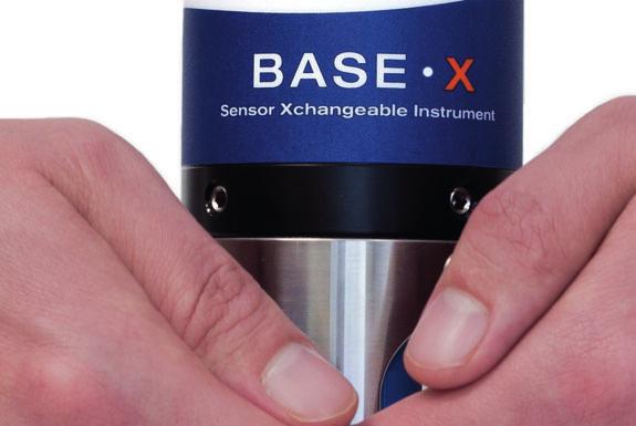
33 Preview A - A Ocean Business 2013 Preview More Variety at an Expanded Trade Show Southampton, in the south of the UK s Hampshire region, will be buzzing from 9 to 11 April 2013 as hydrographic, oceanographic and offshore professionals gather for an even bigger edition of Ocean Business. The organisers expect the 300 exhibitors to welcome 4,000 visitors and delegates to the National Oceanographic Centre grounds and inform them about the latest technologies. Hydro INTERNATIONAL invited exhibitors to give their preview, which we have published on these pages to give you a taste of what s on offer during the event. The outdoor space was crowded in the 2011 edition of Ocean Business. Joost Boers, editorial manager joost.boers@geomares.nl 3D Laser Mapping 3D Laser Mapping is a world-leading provider of laser scanning technology. Established in 1999, our technology draws on many years of experience integrating laser scanners in innovative ways and developing highly effective solutions to multinational companies around the world. Our highly experienced engineering team work with long-standing partners and leading suppliers at the forefront of their technology areas to ensure we deliver high-value and dependable information to our customers. Operating globally through offices in the UK, USA, South Africa and Australia, and a network of specialist distributors, we are able to provide front-line support to a prestigious and growing list of clients. Stand Number: V8 AML Oceanographic AML Oceanographic designs, sells, and services innovative instruments and sensors for many segments of the ocean sensing market. Our customers are located in more than 100 countries and include organisations in the fields of hydrography, science and research, environmental monitoring, offshore construction, and others. As the only provider of Sensor Xchangeable instruments, AML is in a unique position to simplify recalibration, maximise system redundancy and increase return on investment. Over the past 38 years, we have developed a list of engineering firsts of which we are proud. We are confident that our list of innovations will grow as the years roll forward. Stand Number: K8 Applied Acoustics Applied Acoustic Engineering (AAE) debutes their sparker system, featuring an advanced version of the CSP energy source along with non-wearing and long-lasting sparker electrodes on a Squid sound source. Designed to minimise the downtime associated with planned maintenance, AAE s latest concept will provide operational cost savings alongside the company s dual standards of quality and reliability. Additionally, Applied Acoustics will launch an acoustic positioning system to facilitate the accurate relocation of marked subsea targets utilising 2-way spread spectrum signal processing within the smallest possible enclosure, bringing cost efficiencies for operations where targets are deployed for short periods. Both products will be demonstrated on board the Coral Wind. Also on the stand will be the Fatboy and Seabed range of beacons now with Spread Spectrum technology for added accuracy, and running demonstrations of the latest upgrades to the Easytrak Lite and Nexus software. Stand Number: L6 Ashtead Technology Launching at Ocean Business - the Vortex electric dredge pump, specifically customised for small electric ROVs. Exclusively available from Ashtead Technology, this highly innovative product is not to be missed! Ashtead Technology is a world-leading subsea equipment solutions specialist, providing rental equipment, offshore personnel, calibration, repair and maintenance services and bespoke engineered solutions. Find out more about our extensive range of positioning, geophysical, hydrographic and oceanographic equipment, ROV sensors and tooling, visual inspection, diving and NDT equipment at the show. With offshore supply facilities in Aberdeen, Houston and Singapore, and agents in Norway, Australia and Abu Dhabi, we can provide a global, flexible and responsive subsea solution, delivered locally. Stand Number: F8 Vortex electric dredge drawing. Atlas Services Group For more than 30 years, Atlas services Group has been the market-leading provider of personnel to the offshore survey, seismic and construction industry. Professionals working with Atlas have access to a wide range of projects in worldwide locations Hydro INTERNATIONAL APRIL


34 ViSea DPS DATA PRESENTATION SOFTWARE RESON 7125 SV2-FP3 & Applanix POS MV Dual Frequency SeaBat 7125 SV2-FP3 MultiBeam Echo Sounders with Feature Pack Three and X Range Options combined with Applanix POS MV s provide our clients with the latest technology for more efficient and superior quality multibeam surveys. To validate, visualize and manage your ADCP data RESON 7125 SV2 Applanix POS MV No 3254 w ion.nl iinfo@aquavision.nl nl 3254.indd 1 No 3284 today - tomorrow - always w w w. gs erenta ls. co. u k :15: indd 1 Complete hydrographic surveying and dredging software solutions at ss s ine 13 tu s 0 K si u, 2 U Vi n B -11 ton a 9 p ce il m O pr tha A u So HYPACK - HYSWEEP - DREDGEPACK :06:37 HYPACK, Inc. - sales@hypack.com No _HYPACK.indd 1 HYD0313_PreviewOceanBusiness :48: :13:17

 Autonomous Surface Vehicles Ltd (ASV) is a company of naval architects, mechanical, software and electronics engineers specialising in the")
 platforms and supplies a range of unmanned marine gunnery training")

35 A - C due to our extensive network of clients. During Ocean Business, we will be showcasing our offshore survey services and capabilities. Training and workshops will be given on survey principles along with presentations on the importance of competence. We will also be announcing some interesting news, so watch this space. Stand Number: W1 Autonomous Surface Vehicles Ltd (ASV) Autonomous Surface Vehicles Ltd (ASV) is a company of naval architects, mechanical, software and electronics engineers specialising in the design and construction of unmanned marine systems. The company works in the international oil and gas market, conducts specialist military research into mine countermeasures (MCM) platforms and supplies a range of unmanned marine gunnery training targets. The company has supplied over 25 different unmanned surface vehicles (USV) for a wide range of tasks. ASV has recently designed and manufactured a Mobile Station Keeping Buoy C-Stat that has been delivered to a customer in Japan and another vehicle is undergoing significant testing at their facility in Portchester. Stand Number: V22 ASV C-Stat Harbour Trial. Bowtech Technologies The new products being showcased will include: the EXPLORER LITE and PRO cameras, which are the latest in the company s low light camera range, exceeding the performance of the old industry standard SIT camera; the SURVEYOR-HD PRO, highdefinition, ultra-wide angle camera; the OceanLASER-L underwater laser and the new high powered LED-V-SERIES 20,000 lumen LED flood light. Rated to operate at 6,000 metres ocean depth, the lights are manufactured with anodised aluminium, offering proven, corrosion resistance. The 90 wide beam angle light produced, is ideal for illuminating large areas for HD viewing tasks. Stand Number: H5 The LED-V-SERIES 20,000. Chelsea Technologies Justin Dunning will present an overview of fluorescence measurements and their applications to water quality on board RV Callista. He will also present field data and demonstrate the new range of UviLux fluorometers which are configured to measure hydrocarbon, faecal contamination, BOD, optical brighteners & CDOM. Also on board the RV Callista, Dr Kevin Oxborough will demonstrate the new range of FastOcean FRR fluorometers for in situ and in vitro estimation of gross primary productivity. Additional applications include, ballast water monitoring, bloom detection, sea-truthing of satellite data, toxicant detection, coastal monitoring and iron fertilisation experiments to name a few. A full range of sensors will be on display on stand T8. Stand Number: T8 The UviLux fluorometers will be deployed from RV Callista. Chesapeake Technology Chesapeake Technology, Inc. (CTI), the innovation leaders in sonar data acquisition and processing software, will be introducing the addition of SonarWiz Bathy, which will be available later in SonarWiz Bathy will enhance its industry-leading capabilities for side-scan, sub-bottom, and mag sonar data. SonarWiz simplifies the survey process by providing one solution for all customer sonar surveying needs. Surveyors are lead through the workflow methodology with the intuitive, easy-to-use, full-featured software. SonarWiz users worldwide increase productivity, simplify data collection and post-processing, and produce high-quality outputs. Attend the SonarWiz training on Friday 12 April in Southampton, to see for yourself. Stand Number: S5. C-Max C-MAX will be displaying and demonstrating their CM2 side-scan sonar systems with a full range of options and accessories; included amongst these is the CM2 portable power winch. This winch, with a 300m cable capacity, is unique to C-MAX, and allows the sonar operator to remotely control the tow fish depth. Because it uses a low drag stainless steel cable it allows better depth penetration for the tow fish than the common alternative of soft manually hauled cables. Aside from its role in side-scan sonar this winch is also finding other uses such as the deployment of CTD probes. Stand Number: K7 CM2 Portable power winch. Caris, EIVA CARIS and EIVA have signed a Memorandum of Understanding to collaborate on providing offshore survey organisations with a tightly integrated and streamlined solution. Through this partnership the two organisations join forces to provide a world-leading solution for offshore survey projects that includes acquiring and processing survey data through to managing and manipulating the data in an enterprise GIS environment. CARIS and EIVA plan to hold a workshop to introduce this solution at Ocean Business. To pre-register your interest in this workshop, please contact ce.workshop@caris.com as space will be limited. Stand Number: B6 Coastline Surveys Coastline Surveys offers a full range of services to all marine sectors, coastal & offshore, in the UK and internationally including oil & gas, marine renewable energies, ports, harbours & marinas, marine Hydro INTERNATIONAL APRIL


36 The end of data cleaning High resolution soundings with new EM 2040C New model of the EM 2040 multibeam high resolution echosounder now available. The C stands for Compact Like its big brother, the EM 2040, the EM 2040 Compact represents a huge leap in acoustic technology. The extremely clean, accurate data the system produces saves you time and money. SUBSEAING IS BELIEVING No indd 1 HYD0313_PreviewOceanBusiness :44:23 11:13:21


37 D - H minerals and coastal civil engineering. Founded in 1991, with offices in Lowestoft and Falmouth, Coastline provides added-value services to meet the precise survey needs of clients providing fit-for-purpose reports not just standard deliverables. Equipped to acquire geotechnical data up to 20m below seabed in water depths of up to 2,000m with a range of equipment including seabed CPTs, vibrocorers, piston and box corers and grabs. Stand Number: K10 Dutch Ocean Group Eight members of the Dutch Ocean Group will present their latest products and projects in the Netherlands Pavilion (E5). Amongst them are No Limit Ships Shipyards which recently won the order to design and build a hydrographic survey vessel for the Wasser- und Schifffahrtsamt Cuxhaven, Acta Marine presenting its recently delivered Shallow draft DP Multicat Coastal Challenger and RADAC BV showing the latest version of its radar wave-height and wave direction measuring system. Stand Number: E5 A No Limit Ships survey vessel. Elmeridge Cables Limited Brighton, UK-based, specialist cable manufacturer Elmeridge Cables look forward to welcoming you to stand W35, where we will be very happy to answer any questions you may have and to discuss all things cable-related over a complimentary coffee and a stick of Brighton rock! We are proud to launch our new range of Elmtronic high-strength tow cables at Ocean Business, with samples of the new 38-ton breaking strain tow cable (specially commissioned for a military application) available for all to see. We also hope to meet you at the International Wine Trail on the evening of 9 April from 5 7pm. Stand Number: W35 An Elmeridge tow cable. G.O.S.S. Consultants (acquired by Atlas Services Group) Atlas Services Group completed the acquisition of 100% interest in GOSS Consultants Ltd and GOSS (North Sea) Ltd on 8 March. Atlas Services Group has initiated the acquisition to add further scope and options for the combined existing client base and consultants. The companies will integrate and, in the near future, trade under the name of Atlas Services Group. This acquisition brings together two strong agencies in the market of seismic, hydrographic, telecoms, renewable and offshore survey professionals. By combining the best attributes of both companies, the aim is to become first choice for consultants, clients and employees. Stand Number W1 Geosoft Geosoft announces a new UXO Marine software package, providing a purpose-built workflow and tools for processing, detecting and analysing munitions and other buried objects using single magnetometer, Transverse Gradometer and multi-sensor arrays. Marine survey companies will use Geosoft s Oasis montaj software for identifying and classifying pipelines, cables and unexploded ordnance (UXO). Stand Number: V30 HELZEL Messtechnik The new ocean radar system WERA COMPACT 12+ by HELZEL Messtechnik from Germany is the more compact successor of the well-known WERA system. This remote sensing system provides several new features including a wireless connection between the transmitting and receiving unit to provide more flexibility for site geometry, to make the site selection easier and so that it can be operated in different modes. Whether compact or array type antenna layout is used, the WERA system always provides the best solution for your application with outstanding data availability, best spatial and highest temporal resolution. With these shore-based systems ocean currents, waves and wind can be measured more than 200 km offshore from the comfort of your office. A classroom session on WERA will be presented on Tuesday 9 April from 2:00 pm to 3:00 pm in classroom Node 064/03. Stand Number: R5 Helzel s WERA Compact 12+. Hydro INTERNATIONAL Hydro International introduces Geo-matching.com which enables you to compare products before you buy, without having to trawl through the various manufacturers websites. Geo-matching.com features detailed spec-based comparisons of more than 500 products. The website leads you through the maze of specifications and allows you to compare the products of many different producers and read up on reviews given by users enabling you to make a balanced judgment before buying. Or leave your own review! The website brings together all the highly valued Hydro International product surveys, including GNSS receivers, Inertial Navigation Systems, Autonomous Underwater Vehicles, Remotely Operated Vehicles, Side-scan sonar, and Multi-beam echo sounders. Stand Number: R4 Geo-Matching.com Hydrosphere On stand W42 leading supplier of aids to navigation, Hydrosphere UK Ltd, will be promoting a range of meteorological and oceanographic data buoy platforms along with their polyethylene navigation buoys, marker buoys and special marks designed by worldleading buoy manufacturer Mobilis. In addition, they will be showcasing a selection of navigation lights by Carmanah- Sabik and Vega Industries Ltd. Mobilis Jet 2500 buoy. Hydro INTERNATIONAL APRIL


38 HyBIS Operations and deep ocean research to 6000 metres...by a proven and cost effective platform. simple, versatile, manoeuvrable and reliable can normally be interfaced into existing cable and handling systems interchangeable modules to suit varied mission requirements easily deployed from survey vessels or ships of opportunity For further details please contact Hydro-Lek on +44 (0) or enquiries@hydro-lek.com No :33:59 No _HYDROLEK.indd indd 1 HYD0313_PreviewOceanBusiness :22: :13:27


39 I - O With the recent launch of their new rental service, Hydrosphere Rentals Ltd, these products are now available to rent as well as purchase. For more information call , sales@hydrosphere.co.uk. Stand Number: W42. Idronaut Idronaut presents the VERTIGO, a compact tethered free-falling microstructure profiler for easy and straightforward measuring of fine structure and dissipation-scale turbulence, equipped with the most important oceanographic sensors, at their stand V20. Its advanced development was carried out in collaboration with the P.P. Shirshov Institute of Kaliningrad - Russia. Another exhibit on the stand is the OCEAN SEVEN 303HT High- Temperature Multiparameter Probe (CTD, O 2, ph, ORP) which operates at temperatures up to 105 C and a pressure of 400bar. This was developed in the framework of the EUROSTAR E! 5964 HIGHTEMP Probe project, in collaboration with FLODIM - France. The other new products, OS304Plus and OS305Plus, will be presented in a dedicated classroom as well as at the stand. Stand Number: V20 Kongsberg Geoacoustics Kongsberg Geoacoustics is the supplier of GeoSwath Plus COMPACT, the market-leading portable shallow-water multibeam system. GeoSwath Plus COMPACT 250kHz single head. Over 200 GeoSwath systems are in operation worldwide and users include leading commercial survey companies, environmental mapping agencies, hydrographic offices and marine research institutes. Stand Number: P2 Kongsberg Maritime Kongsberg Maritime will unveil a new AUV and introduce a new variant of its EM 2040 multibeam echo sounder during Ocean Business Other highlights from the leading subsea technology developer include the return of the popular Kongsberg Maritime demo boat, with on-water demonstrations of cnode underwater positioning and data link transponders. Live cnode demos will run every afternoon during Ocean Business and interested parties are invited to register on the Kongsberg Maritime stand as early as possible to avoid disappointment. Kongsberg Maritime Ltd meanwhile, will focus on its growing rental portfolio, which now includes the REMUS 100 AUV from Kongsberg Hydroid. Stand Number: N1 Measurement Devices Ltd Measurement Devices Ltd. (MDL), A Renishaw Group company, is a complete solutions provider, designer and manufacturer of rugged laser measurement systems for use in extreme environments. MDL will be showcasing our Fanbeam and Dynascan products. Our Fanbeam is a DP reference system, which is used on over 1,500 vessels worldwide. MDL s Dynascan mobile mapper is ideal for marine based applications and can be mounted on any moving platform. Please see us for a demonstration at the show. In addition to product sales, MDL s Technical Services Division offers equipment hire, data processing and project support to help customers throughout their projects. Stand Number: W15 Marine Training Company (MTCS) Ltd ROV downtime is extremely expensive, both in terms of lost productivity and reputation, so Fault Finding is an important skill to have. It is with this in mind that marine trainers, MTCS Ltd, will be launching their new, ROV Fault Finding Distance Learning programme at the Ocean Business Exhibition, Southampton, on Tuesday 9 April 2013, 9.30am. The MTCS distance learning ROV Fault Finding Programme will cover: the generic fault finding principle; common faults with work class ROV systems; faults particular to a specific configuration or manufacturer; practical exercises and simulated exercises. Stand Number: V19 NCS Survey NCS Survey has recently established two international offices; Rio de Janeiro and Stavanger. These offices allow the company to build its strong track record in rig positioning, construction support, real-time visualisation and AUV services, with a local presence in both of these regions. In addition, the company has expanded its growing AUV fleet with the purchase of two Teledyne Gavia AUVs. These vehicles are the latest in the Gavia Offshore Surveyor series and are equipped with high-resolution SSS, MBES, SBP, USBL, LBL, GPS and INS. The AUVs are used to provide ultra-highresolution data for pipeline and platform inspections; scour monitoring surveys; cable and pipe route surveys; and offshore wind farm surveys. Stand Number: M2 Norcom Technology Norcom Technology Limited is an independent software development company specialising in marine navigation software and hardware. Norcom will be exhibiting its electronic charting software and demonstrating its working in conjunction with a Smartfind S10 personal AIS Beacon which transmits a unique alert signal within a typical 4 mile range. Stand Number: S10 Norcom Technology is exhibiting its charting software. OceanTools Ltd OceanTools Ltd is an independently owned, world-leading subsea engineering company specialising in design and manufacture of subsea equipment. Deployed in harsh environment applications including subsea survey and ROV operations, OceanTools products are field proven, trusted and reliable. Visit stand G9 to see the OceanSENSE Leak Detection and Cement Confirmation System, the new OceanSURVEYOR subsea survey frame comprising of OceanFOG fibre optic gyrocompass, OceanDISP subsea display, SmartPOD data concatenator, MA500 highprecision altimeter, Digiquartz depth sensor and C-Switch underwater switch, our new range of 3,000m electric Pan & Tilts and our market-leading High Definition Overlays. Stand Number: G9 Ohmex TweetM8 live tide and weather information using Twitter is presented at OB2013 by Ohmex. A pilot suggested using Twitter as data provider. He sometimes had to berth when the harbour office was closed and nobody Hydro INTERNATIONAL APRIL


40 No :33:09 No indd indd :44:25 Multibeam System SeaBeam 3050 Mapping the Continental Slope No 3283 L-3 ELAC Nautik s SeaBeam 3050 multibeam echo sounder collects bathymetric, corrected backscatter, sidescan and Water Column Imaging (WCI) data in medium depth over a wide swath in excess of 140 degrees, meeting all relevant survey standards. Due to its depth performance in combination with wide coverage, SB 3050 is the ideal hydrographic sensor for mapping the continental slope. The system operates in the 50 khz frequency band in water depths ranging from 3 m below the transducers to approx. 3,000 m. The new multi-ping technique compensates fully for vessel pitch and yaw motion and transmits and processes two swaths in one ping. Visit us at ocean business, booth no. Q11! 3283.indd 1 HYD0313_PreviewOceanBusiness 40 elac-nautik.com :46: :13:30


41 R - S could relay tide and weather information. The suggested IT solution using a tablet application did not allow for the poor internet service offshore. The Twitter service, available for web-based users and SMS text messages, could include gauge location information, UTC timestamp, keep last two days tweets available, user-controlled tweet following and distribution and wide availability of data through mobile web applications and clients. During OB2013 there will be a demonstration of live data from a gauge located along the eastern side of the NOC dock area, to follow on and Stand Number: W30 Rapp Hydema The contract delivery covers the turn-key delivery of two complete Work Class ROV Moon Pool Handling Systems. In addition, delivery covers fabrication drawings for: ROV skidding pallet, ROV moon pool hatches, cursor rails with parking assembly and centerline lower hatches. Rapp`s delivery covers the hydraulic drive and control system for all hatches and ROV skidding pallet on the vessel. The Constellation ROV handling will be the latest generation of ROV handling systems designed for Work Class ROV operations down to 4,000 metres in harsh weather and high speed. All winches are fully electric, high speed and each moon pool system has full redundancy in all critical components. Delivery by Rapp Hydema will take place in spring Stand Number: P9 EMAS Arrangement. RIEGL The Austrian manufacturer RIEGL gives an insight into the latest developments in hydrographic and marine mobile mapping at booth V8 in the dockside exhibition hall. The RIEGL VQ-820-G hydrographic airborne laser scanner offers combined land and hydrographic airborne survey of coastlines and shallow waters integrated into a complete platform for airborne scanning, easily installed in any type of aircraft platform, e.g. fixed wing or helicopter. Moreover RIEGL presents the application of the VQ-Series Laser Scanners in combination with multi-beam sonar systems for shipborne mapping. Latest information on actual projects will be given in the RIEGL training session on Thursday 11 April 2013, from 9 to 10 am, in the Ray Beverton Room. Stand Number: V8 RIEGL VQ-820-G Hydrographic Airborne Laser Scanner. Saderet On the Saderet stand, Hemisphere GPS introduces the Vector VS330 GPS compass system that provides highperformance heading, position, heave, and attitude data. The new Vector is designed for professional marine applications such as hydrographic and bathymetric surveys, dredging, oil platform positioning, and buoys that demand the highest level of 3D positioning accuracies. Based on Hemisphere GPS Eclipse GNSS technology, the Vector VS330 utilises the most accurate differential corrections including RTK, L-band, SBAS, and beacon with the smart MFA firmware automatically selecting the best solution available. The Hemisphere VS330 GPS Compass. Since 1998, Saderet has been serving the offshore survey community specialising in the supply of quality navigation, oceanographic and survey equipment. Stand Number: K12 SIG France SIG France will be launching its new energy source for sparkerboomer seismics. The new energy source has lost weight: minus 40 kilos on the single box. Objective: easy mobilisation-demobilisation in a robust case, easy to use, but 100% safe; 100 to 2,000 joules power supply, with steps of 100 joules, and high voltage from 3 to 4kV. This new energy source will replace the SIG 2mille which was increasingly found on the research vessels over the past 10 years. Stand Number: V35 The new energy source. Sonardyne Daily in-water demonstrations will be a key focus of Sonardyne s offering at this year s Ocean Business in Southampton whilst inside on the company s expanded stand, visitors can explore four different technology zones; acoustic positioning, inertial navigation, wireless communications and sonar imaging. Application experts will be on hand to offer guidance and advice for any subsea projects with Sonardyne s Survey Support Group also running daily acoustic and inertial positioning technique workshops. Sonardyne will also be hosting a Wine Trail station on Tuesday 9 April and sponsoring the prestigious annual Gala Dinner on Wednesday 10 April at Southampton Guildhall. Stand Number: E1 The Sound Surveyor is hosting demos during Ocean Business. SubCtech The company SubCtech is an internationally operating company based in Kiel, Germany. As a developer of marine technology and underwater power supplies the company presents a product family of pco 2 analyser and complete mobile and stationary environmental and water quality monitoring systems. This family was recently completed by a pco 2 Lab analyser which will be launched at OB In addition, a new water quality monitoring system for mariculture applications and deep-sea, offshore Li-Ion battery technology for underwater applications down to 6,000m will be introduced. Hydro INTERNATIONAL APRIL


42 Preview QINSy The modular design, user friendly user interface, comprehensive help and support of international standards and exchange formats, mean QINSy is equally well suited to less complex bathymetric surveys as it is to highly complex multi-vessel and multi-sensor offshore construction projects. Hydrographic Laser scanning Rig moves Dredging Pipe laying Rock dumping Offshore Sidescan Sonar ROV inspection Marine Data Management Fledermaus Fledermaus is the industry leading interactive 4D geospatial processing and analysis tool. The intuitive user interface allows users to rapidly gain insight Coastal mapping Environmental Exploration Geological Habitat mapping Hydrographic Academic Offshore Marine construction Marine Data Management and extract more information from their data, that in turn promotes data processing efficiency, quality control accuracy, and data analysis completeness. The company with the solutions for your hydrogeomatics data and maritime projects QINSy Qastor Fledermaus No APRIL 2013 Hydro INTERNATIONAL For details contact:


43 S - V Please see us at SubCtech Booth G10 and Rs Aqua Booth G1, our appointed representative for UK & Ireland. Stand Number: G10 Swathe Services This year at Ocean Business R2SONIC and their UK distributors, Swathe Services, have teamed up with MSDS Marine and their survey vessel Shogun to demonstrate the SONIC 2024 and SONIC 2020 multi-beam echo sounders. Customers will be able to see first-hand the Ultra-High-Resolution 700kHz with 0.3 beam width resolution and TruePix capabilities of the system. Demonstrations will be undertaken hourly, after registration at the Swathe Services stand W19. In addition to this, managing director James Williams will be presenting a paper at the Offshore Survey Technical Conference on The OceanScience Group s Z-Boat an innovative platform for mapping difficult areas to access. Stand Number: W19 Survey Vessel Shogun will go out demonstrating R2Sonic multi-beam echo sounders. Teledyne Blueview Teledyne BlueView, the world leader in compact acoustic imaging and measurement technology will showcase its new mini M Series 2D Multibeam Imaging Sonar and ProViewer 4.0 operating software. The new M Series is 30% smaller, 30% lighter, and uses 30% less power that the popular P Series. The M Series with the all new ProViewer 4.0 operating software delivers new functions and features that make your job easier. Tuesday 9 April - Dockside, from 5:00 to 6:00pm a live BV5000 3D Multibeam Scanner demo will demonstrate the unique underwater imaging and measurement capabilities of the BV Stand Number: T2 Dockside deployment of the BV5000 multi-beam scanner. Teledyne Odom Hydrographic With nearly 30 years of experience in designing and manufacturing precision, digital hydrographic instruments, Teledyne Odom Hydrographic is one of the world leaders of velocimeters, single and multi-beam echo sounders. See us on Booth S1 and sign up for on-water demonstrations being offered during the conference. Stand Number: S1 Odom MB1 Multi-beam echo sounder. Teledyne RDI This year at Ocean Business, Teledyne RD Instruments will have on display a sample of their Acoustic Doppler Current Profilers (ADCPs) for current profiling and waves measurement; Doppler Velocity Logs (DVLs) for underwater navigation; CTDs for conductivity, temperature and depth readings; and Carbon Sensors for underwater C02 and CH4 detection. Teledyne RD Instruments, in conjunction with Teledyne Webb Research, will also offer a classroom presentation on T-RDI s new Explorer ADCP, which has been successfully integrated into Teledyne Webb Research s Slocum Glider in support of the Ocean Observatories Initiative (OOI). The Explorer ADCP, with bottom tracking capability, collects high-resolution current profiling data from a glider or other autonomous platform. Stand Number: S1 The Acclaimed Software The Acclaimed Software is pleased to announce the renewal of their agreement with Veripos for further development of their leading positioning software Verify QC. At Ocean Business EPOCH, the graphical marine management software developed for OMM (Offshore Marine Management) providing live reporting between offshore and onshore, will be demonstrated. They will also unveil their iobox, allowing operations to be recorded or performed to the millisecond within applications on non-real-time operating systems. To celebrate their 10th year, The Acclaimed are offering free access to PatchBox during Ocean Business. Patchbox links multiple data inputs and outputs, enabling redistribution of data, e.g. collecting and sharing positioning, monitoring or survey data supplied by multiple sensors. Stand Number: M3 The Hydrographic Society UK An official supporter of Ocean Business 13 and Ocean Careers as well as a co-organiser of the accompanying two-day Offshore Survey conference, The Society is exhibiting a full range of literature and services maintained for its sizeable domestic and overseas membership representing hydrographic and related disciplines at all levels of expertise. Publications include the latest edition of the newsletter, Soundings. Fringe events include staging of the 9th Annual General Meeting on 10 April during which there will be a formal announcement of The Society s inaugural Fellowships. Stand Number: F11 Ubifrance The French Trade Commission UBIFRANCE will showcase a number of French ocean technology specialists on Stand T5 at Ocean Business CADDEN is a specialist in electronic measuring systems for geopositioning and oceanography; Ifremer is the French research institute dedicated to sea exploitation; nke Instrumentation provides solutions for in-situ measurements; SBG SYSTEMS manufactures motion-sensing solutions; SUBSEA TECH specialises in a range of marine and underwater technology; IN VIVO provides marine environmental and oceanographic consultancy services; ACSA specialises in undersea robotics and positioning systems; and, finally, Sea Tech Week 2014 is an international marine science and technology event that will take place in Brest, Brittany (France) in October Stand Number: T5 Veripos A world leader for satellite positioning services, Veripos presents its latest independent high-accuracy capabilities using combined GPS and Glonass capabilities, Apex2 and Ultra2. Each provides two sources of corrections, algorithms and availability of at least two delivery satellites. Also featured alongside purpose-designed QC software modules is Verify Axiom, a new inertially-aided solution for DP applications. Developed in association with Sonardyne and using its Lodestar INS, it ensures Hydro INTERNATIONAL APRIL


44 Twelve companies, a sea of solutions. BENTHOS BLUEVIEW DGO GAVIA GEOPHYSICAL INSTRUMENTS IMPULSE ODI ODOM HYDROGRAPHIC RESON RD INSTRUMENTS TSS WEBB RESEARCH From the surface to the seafloor, the Teledyne Marine companies deliver the products, technology, and talent you demand to get the job done. No Find your solution at indd 1 HYD0313_PreviewOceanBusiness 44 Visit our member companies at Ocean Business on booths S1, T2, L15, and R :51: :13:40


45 W - Z enhanced performance in times of high ionospheric noise, signal blockage or interference. It also enables a single navigation solution to be computed and displayed, with industry-standard telegrams available for external interfacing. Stand Number: U12 WASSP With a stronghold on the commercial fishing market, WASSP is now offering an advanced and backward compatible solution to its existing target market, and has focused on enhancing the common functions and features also used by professionals in the hydrographic survey and work boat market. Guests will be able to see how intuitive the system is and how quickly the system will gather seafloor and water column information during live on-water demonstrations. Using 112 or 224 beams, WASSP multi-beam sonar gives a wide-angle 120-degree portstarboard view. The viewing span is over 3 times sea depth, and WASSP can profile an area over 100 times faster than a single beam system. Stand Number: P8 WASSP will be carrying out live on-water demonstrations with their multi-beam sonar system. Xsens Technologies In 2012, Xsens launched the 4th generation MTi, including 7 distinctive products (MEMS IMU, VRU, AHRS and GPS/INS). After the initial launch in August 2012, first additions to the firmware and software were released in December The easy-to-use MT Software Suite allows straightforward integration, resulting in the first series customers that will be able to integrate the new MTi s immediately. At Ocean Business, Xsens will showcase the new MTi for the first time to the maritime community. Xsens is the leading innovator in 3D motion tracking technology and sets the standard in MEMS IMUs, VRUs, AHRSs and GPS/INSs. Stand Number: D10 The 4th Generation MTi of Xsens. CEEPULSE 100 series Next generation black box survey echo sounder Advanced features: m ( ft) depth capability Membrane interface with 6 status LEDs Shallow Auto, Auto and Manual user modes Capable of up to 10 Hz ping rate Bluetooth conectivity Manufactured using high quality components and is environmentally sealed No Hydro INTERNATIONAL APRIL


46 Never lose North. DION Smoothed Positioning Quartz Lock Loop IP67 Water/Dust Protection VISOR Heading Precise RTK Positioning GPS+GLONASS Universal Tracking Channels Topcon s MR-1 re ceiver and MG-A8 antenna deliver high performance RTK positioning and head ading in har arsh environments, whi le not b eing sus usce cept ible to signal jammimi ng. World s lightest t compact, multi- RTK positioning i and heading In-band interference rejection. constellation, dual frequency receiver. determination in a format that fits. Comprehensive connectivity. Onboard data logging. o You need positioning, we have the solution. Learn more at topconoemsolutions.com

 could fit in to existing or developing national SDI.")

47 IHO Publications International Hydrographic Organization Global Geospatial Information Management and Marine Spatial Data Infrastructures For the IHO, Marine Spatial Data Infrastructure (MSDI) means the technology, policies, standards, and human resources necessary to acquire, process, store, distribute, and improve the use of marine geospatial data. In May 2007, the IHO established a Working Group on Marine Spatial Data Infrastructures (MSDIWG). Its role was to identify how Hydrographic Offices (HOs) could fit in to existing or developing national SDI. IN 2009, THE MSDIWG completed a guidance document IHO Publication C-17 Spatial Data Infrastructures: The Marine Dimension - Guidance for Hydrographic Offices. C-17 provides general information to assist HOs and other authorities in the identification and implementation of their roles in national SDI. The next stage of activity for the MSDIWG is to propose ways for HOs to implement MSDI - using examples where this is already happening successfully. The MSDIWG is studying the technical, organisational, policy, Cover of IHO Publication C-17. MSDI Open Forum and IHO MSDIWG Meeting, Copenhagen, February educational and scientific aspects of MSDI and has identified a number of challenges and opportunities that exist for HOs, together with the role that they can play in supporting socio-economic development worldwide. Key challenges identified for the IHO include: supporting how IHO Member States can adapt to new ways of working sharing existing knowledge and experience across the HO community making the case for MSDI. MSDI developments fit well with national, regional and world-wide initiatives aiming at supporting environmental policies. Although SDI developments are led by the land mapping and cadastral agencies in most countries, the maritime dimension is increasingly acknowledged as an important element, especially to implement integrated maritime policies. The results of a recent survey on MSDI conducted among HOs by the MSDIWG revealed that the dominant issues facing HOs are to identify responsibilities for MSDI development, clarify user needs across the relevant sectors, data interoperability, harmonisation and standardisation, and not least - funding. Data interoperability, harmonisation and standardisation is addressed by the new series of IHO standards based on S-100, the Universal Hydrographic Data Model. In parallel with the work of the MSDIWG, the IHO, as an accredited Observer at the United Nations and a participant of the UN Committee of Experts on Global Geospatial Information Management (GGIM) is contributing to the standardisation of global geospatial data and also the development of a UN sponsored Global Map for Sustainable Development. These UN initiatives give further weight to the need for the IHO and its Member States to develop their roles in MSDI as a significant supporting element of SDI. The HO engagement in SDI creates greater appreciation of the value of hydrographic information and will favour its wider use in new products and services, improved decision making (such as integrated coastal zone management, disaster mitigation and climate change adaptation). Efficiencies will be gained with the measure once use many times principle. At the same time, MSDI developments expand the need for reliable, high-density source data. The next MSDIWG meeting, to be associated with a second MSDI Forum, has been planned for February 2014, most likely in North America. Robert Ward President, International Hydrographic Organization, Monaco Hydro INTERNATIONAL APRIL

48 History Cosmos tied up next to a C-GS ship. First Command Ensign Niblack Showed Himself to be a Decisive and Courageous Captain Albert E. Theberge Jr., Contributing editor, Hydro INTERNATIONAL Albert Parker Niblack, third director of the International Hydrographic Bureau from 1921 and second President from 1927, had been an officer in the United States Navy for eleven years when he earned his first command. In 1887, he was thirty years old and had been attached to the Coast and Geodetic Survey Steamer Patterson for the past three years. HE WAS APPARENTLY A PLANK owner on the Patterson as he was assigned to the vessel on 2 July 1884, in New York City. The ship began its voyage to the Pacific Ocean on 30 July 1884, and arrived in San Francisco on 13 February Highlights of the trip, according to seaman Thomas Ellingson, were a long layover in the Madeira Islands where the wine flowed freely and a stop in Rio de Janeiro where Pedro II, Emperor of Brazil, toured the ship. San Francisco was the ship s home base for a number of years but its work was primarily in Southeast Alaska. The ship sailed for Alaska in late April and commenced its first hydrographic survey on 1 June This first season, Niblack was assigned topographic surveying duties and thus was afforded the opportunity to become familiar with the native American Haida and Tlingit Indians for whom the Pacific Northwest was home. During the 1886 field season, Niblack was in charge of triangulation and possibly was a pioneer in using steel wire for measuring a baseline as Two baselines were measured by means of sounding wire led over tripods, stretched taut with large reels, and levelled with theodolites. This marked Niblack as an original thinker and problem solver. During field operations, the long distances between the ship s working grounds in Alaska and sources of supply made it necessary to operate the Patterson in company with a tender. Initially the ship used a tender called the Lively, which was also used by the Coast and Geodetic Survey Steamer Hassler. Accordingly, arrangements were made for the construction of a steam launch which was ultimately christened the Cosmos. She was 52 feet in length, 12 feet in beam, and 8 feet in draft. On 4 May 1887, the Patterson departed San Francisco for its working grounds with the brand new Cosmos in tow. Ensign Niblack was in command of the Cosmos and had a small crew consisting of another officer, a seaman, a fireman, and a machinist mate. Three days later the hawser between the Patterson and the Cosmos broke during a storm off Cape Gregory (today known as Cape Arago), Oregon. Niblack wrote a detailed report concerning the experiences of the Cosmos over the next five days. Excerpts follow: 48 APRIL 2013 Hydro INTERNATIONAL

49 Cosmos and sounding boat in small bay.. When the chain span parted at 9:45 a.m. I rang the engine room bell for starting ahead. F.W. Lennox, fireman, in endeavouring to clear some obstruction in the forward crank unfortunately got his arm and hand caught by the descending crank and pinioned there. Had we been able to steam ahead immediately after the bell was rung, we no doubt would have been able to steam up to the ship even in the heavy sea and pick up the tow line again. As it was we fell off into the trough of the sea, lost sight of the ship in the thick mist, and all hands were busy trying to extricate the man s arm. As soon as we were able to go ahead we got over the sea anchor and rode to it. About fifteen minutes afterwards the chain parted and we again fell off into the trough of the sea. The high pilot house forward and the Whale s back made it very difficult and expensive of steam power to keep the launch s head up to sea. From dead reckoning I concluded that our distance from shore and from our nearest northern port made it imperative to save coal and water. ( ) The wind increased in heavy squalls with rain, the worst squall shaking us about 4 p.m. The seas were as heavy as I have ever seen and I consider it both good luck and a good sea boat that carried us through. It moderated at 5 p.m. We spread fires and at 5:45 p.m. ran in shore. At 8:30 p.m. we made Cape Gregory Light and at 9:15 p.m. took departure and headed up the coast. We had then about 3 tons of coal and half our fresh water left. We arrived off the Columbia river bar at midnight Sunday 8th May. At daylight three pilot tugs came out and we spoke the Pioneer. We were told that all vessels were bar bound inside and had been for three days; that the McArthur [a Coast and Geodetic Survey ship] was at Astoria waiting to get out; that the bar was getting safer all the time; and finally that one of the tugs was going back in soon and we might risk following her in. We were out of fresh water and using sea water in the boiler; had about a half ton of coal left; the weather was unsettled; and the condition of Lennox, the fireman, required medical assistance. Although a small vessel, the Cosmos showed itself to be a magnificent sea boat during this ordeal. Ensign Niblack showed himself to be a decisive and courageous captain in safely bringing his vessel to a safe haven. He also showed himself to be a good leader as he certainly gave credit where credit was due to enlisted and officer personnel alike. The Cosmos was resupplied with the help of the personnel of the McArthur and continued on to a rendezvous with the Patterson at Port Townsend, Washington, where it once again continued in company with that vessel to Southeast Alaska. If enough adventure had not already been the lot of Niblack and the Cosmos, while transiting to Port Townsend, it fell in with a fishing vessel that had rescued 25 men from the four-masted ship Ocean King that had foundered off Cape Arago, not many miles from where the Cosmos had weathered the storm. The 25 men were transferred to the Cosmos and transported to Port Townsend. Of this episode, the commanding officer of the Patterson wrote: It is impossible to speak in too high terms of the conduct of Ensigns A.P. Niblack and A.N. Beecher, and of the crew of the launch in successfully handling so small a steamer in one of the severest gales I have ever experienced. The machinist, Maurice Goulden, is an exceptionally competent man, and to his coolness, judgment and indomitable pluck may be attributed the safety of the Cosmos. Hydro INTERNATIONAL APRIL


50 in our element Tide Gauges No


51 Not to be outdone by the Surveyor s ship s pet cat, the the survey launch Cosmos has a pet deer. Steam Launch Cosmos. Niblack was one of the navy s intellectuals as shown by the range of subject matter in his publications. Following detachment from the Patterson he completed the classic ethnographic work the coast Indians of southern Alaska and northern British Columbia in This work was based on copious field notes and photographs that he took while attached to the Coast and Geodetic Survey. The following year he wrote the winning prize essay of the U.S. Naval Institute on The Enlistment, Training and Organization of Crews for Our Ships of War. He wrote the winning essay again in 1896 with a paper on The Tactics of Ships in the Line of Battle, and then in 1906 received first honourable mention with The Elements of Fleet Tactics. However, it was not until 1904 that he received another command, being the 702-ton fleet tug Irocquois. Things proceeded rapidly from this time on though as he went on to command the USS Hartford, a training and cruise ship for midshipmen; the cruiser USS Olympia also as a training ship; and then during World War I as commander of Division I, Atlantic Fleet, with the battleship Alabama as his flagship. Following the war he served as chief of Naval Intelligence; commander of U.S. naval forces in European waters; and then a final assignment as commander of the 6th Naval District based out of Charleston, South Carolina. He retired from this post in 1923 as a Vice Admiral and the following year was elected a director of the International Hydrographic Bureau (IHB) in Monaco and its president in He published a number of documents between 1924 and his death in Among them were IHB Special Publication 19: Ocean currents in relation to oceanography, marine biology, meteorology and hydrography, a discussion of bathymetric terminology, and various papers on chart production methodology. Vice Admiral Niblack outlived his first command by two years. The Cosmos had an illustrious career of its own helping survey the waters of Southeast Alaska for forty years before being condemned and sold in Two generations of hydrographers had worked upon her decks while surveying the little-known waters of Alaska. The little vessel, with Niblack at its helm, survived its first harrowing trip. One wonders if the Admiral was aware of the little vessel s final disposition and gave a final salute and a hearty Well done! Today, Southeast Alaska is graced with several names commemorating both Niblack and the Cosmos. There is Niblack Anchorage, Niblack Islands, Niblack Point, and Niblack Hollow. Interestingly, there is a proposed Niblack Mine near Niblack Anchorage which may necessitate further hydrographic work to assure safe passage for marine transport of the mined ore. Echoes of the Cosmos remain at Point Cosmos, Cosmos Cove, Cosmos Pass, Cosmos Peak, Cosmos Point, and the Cosmos Range of mountains. Hydro INTERNATIONAL APRIL


52 Business Figure 1: Comprehensive dataset of a small dock collected by mobile survey launch. Comprehensive Marine Solutions Meritaito Jani Pötrönen, Meritaito, Finland Meritaito is a Finnish company with decades of experience in shallowwater hydrographic surveys, hydraulic engineering, waterway design, maintenance of waterways, oil spill response and manufacturing of aids to navigation. Meritaito s personnel is used to working in challenging shoaly waters and even winter conditions. MERITAITO WAS FOUNDED IN the beginning of The company headquarters are located in Helsinki, the capital city of Finland, and additionally Meritaito has a nationwide network of smaller posts around the Finnish coast and inland lake area. State-owned Meritaito was formed from the former Finnish Maritime Administration (FMA). In 2010, Meritaito began with around 300 employees who continued the work of Finnish Maritime Administration in Finnish water areas. Today the market where Meritaito operates in is also open to private operators, so the company s operational environment has changed considerably over the past three years. Meritaito is the biggest Finnish marine survey service and waterway maintenance operator. Meritaito provides high-quality expert services and intelligent solutions that support the sustainable use of sea and inland water areas. Meritaito s international SeaHow brand offers solutions for marine surveys, intelligent maritime environmental monitoring and oil spill response solutions. Today, 220 professionals work for Meritaito with a turnover of around EUR32 million (2012). Marine Surveys The majority of the operations of Meritaito s marine survey service are based on the purchase orders of the Finnish Traffic Agency (FTA) for hydrographic surveys for nautical 52 APRIL 2013 Hydro INTERNATIONAL


53 Figure 2: Hydrographic survey catamaran Kaiku. Figure 3: Geotechnical investigation platform Esko. Figure 4: Diver in winter conditions. charting. Meritaito also supports offshore wind farm planning, pipeline laying and other marine construction projects with versatile site investigations including geotechnics in addition to smaller scale marine surveys for other private sector customers. R&D work in marine surveys has recently focused on developing marine infrastructure inspection capability especially with Meritaito s small survey launch. One of the main goals has been to develop effective ways to use high-resolution multibeam surveys, mobile laser scanning and scanning sonar technology to gather comprehensive information of coastal infrastructure above and below the water surface. Good results in ports and with other coastal infrastructures have been gained to develop a concept and methods which would decrease the need for traditional and time-consuming diving operations in these kinds of inspections. Multi-beam surveys and mobile laser scanning provide us with a tool to obtain a comprehensive view of a location on a larger scale, and to recognise potential targets for further inspection. These specific targets can then be inspected more closely, for example, by professional divers, or alternatively by using scanning sonar technology, which offers the most accurate method to inspect underwater structures locally without the need to worry about visibility or strong currents. Marine Monitoring Solutions SeaHow marine monitoring products and solutions provide real-time and in-situ marine data to wherever it is needed. Combining wireless ICT and modern battery technology with remote sensors from Meritaito s partners and a robust buoy platform manufactured by Meritaito creates smart solutions to support safety of navigation and collection of environmental data. Data can be repurposed and delivered either to a web interface or integrated to a customer s systems. New Generation of Oil Recovery Meritaito has developed a new generation of SeaHow oil recovery products and solutions, which are based on several innovations bringing significant cost savings and improved recovery results when compared to traditional technology. The key targets of the planning process have been easy deployment and a continuous recovery process. With this product family a comprehensive range of vessels can be equipped and various application environments can be covered. Future Prospects Opening of the Finnish market has of course changed much for the everyday operation of Meritaito, but the personnel has adapted very well. According to the CEO, Jari Partanen, Meritaito relies strongly on its professionals and the expertise gained over decades of working in this special northern environment. Meritaito provides high-quality expert services and intelligent solutions that support the sustainable use of sea and inland water areas and they aim to be one of the leading experts in the Baltic Sea region. Hydro INTERNATIONAL APRIL


54 Products When things get this ugly you need more than just another pretty face. Th t where That s h I come in. Sure, I m a great looking Acoustic Doppler Current Profiler, but you know what they say it s what s inside that really counts. Like the 20,000 instruments delivered before me, I m the direct result of the over 200 Teledyne RDI employees committed to making me the most dependable product in your arsenal, and providing you with the support you need to get the job done. Yep, I m the entire package and I m here to help you conquer your next deployment. Find your solution at MEASURING WATER IN MOTION AND MOTION IN WATER. A Teledyne Marine Company 3292.indd 1 The Service Hydrographique et Océanographique de la Marine (SHOM, France) has made 3D marine currents available at the surface, mid-depth and seafloor levels. The English Channel is the first area to be covered. The information contains vectorised data on the water levels, the speeds and the directions of the currents, georeferenced maps displaying the current area and maps of the maximum current speed. The SeaSoar in deployment. SeaSoar Towed Oceanographic System Delivery Inside me you ll find the heart of a lion. I ll be there when you need me, consistently delivering the quality current profiling and wave data you need, even in some of the world s harshest environments. No D Sea Currents of the Channel The Institute of Oceanology Chinese Academy of Sciences (IOCAS), Qingdao, has just taken delivery of a Chelsea SeaSoar towed oceanographic system. The sale was facilitated through Chelsea s agents China ORES Co Ltd. The SeaSoar System is fitted with a Chelsea MiniPack to measure conductivity, temperature, depth and fluorescence plus sensors to monitor turbidity and PAR. A Chelsea Plankton Sampler with flow metre has also been integrated plus third party instrumentation :59:25 54 A P R I L 2013 Hydro INT E R NAT IO NA L HYD0313_Productnews :07:55


55 Underwater Lidar System The INSCAN underwater laser imaging system was presented by CDL, UK, and 3D at Depth, USA. The system provides fast, high-resolution 3D data capture for surveying, as-builts and monitoring, and was showcased at the Subsea Tieback conference. INSCAN is a subsea Lidar system that uses proprietary technology developed by 3D at Depth and engineered by CDL for use in subsea environments up to 3,000m in depth. The system collects up to 40,000 points per second, provides a 360 degree x 30 degree field of view and can either provide real-time operator measurements or output to industry-standard point clouds. Nautical Charts for Arctic NOAA s Office of Coast Survey has issued an updated Arctic Nautical Charting Plan in a major effort to improve chart coverage for Arctic areas experiencing increasing vessel traffic due to multi-year ice retreat. This leads to new maritime concerns about adequate charts, especially in areas increasingly transited by the offshore oil and gas industry and cruise liners. The INSCAN Underwater Lidar system. Two More Sparkers for KIOST KIOST, Korea, has reaffirmed its confidence in SIG 2mille sparker energy sources. KIOST s vessel is based at the Leodo Jangmokho shipyard. The sparker is used in the study of sediment transport in the Yellow Sea, and the west coast of Korea. ixblue to Launch ComMet and GAPS NG During Ocean Business, to be held from 9 to 11 April 2013, ixblue will present its subsea positioning solutions, a significant revolution in subsea positioning, demonstrating groundbreaking technology that will change the face of subsea navigation: the ComMet (image) combines acoustic and inertial metrology systems and a new generation of GAPS NG. ixblue is to introduce ComMet. More product news productnews.php No 3297 Hydro INTERNATIONAL APRIL
 Ricardo Ramos Freire, cartographic engineer, Western Nautical Signalling Service, Brazil A major part of Paraguay River")
56 Organisations Figure 1: SSN-6 s current building. Western Nautical Signalling Service 58 Years of Paraguay River Mapping LT(Eng) Ricardo Ramos Freire, cartographic engineer, Western Nautical Signalling Service, Brazil A major part of Paraguay River s sounding and signalling is maintained by the Brazilian Navy. Trying to stay abreast of the state of the art on inland hydrography and cartography, the Western Nautical Signalling Service briefly presents its past, current status, innovations and its vision on the future. ON 18 MARCH 1955, THE MATO Grosso Nautical Signalling Service (Serviço de Sinalização Náutica do Mato Grosso SSN-MT), of the Brazilian Navy, was founded to provide Inland Safety of Navigation by establishing Paraguay River s signalisation. Its first director was LCDR Fernando Pereira das Neves. In 1967, SSN-MT was renamed Western Nautical Signalling Service (Serviço de Sinalização Náutica do Oeste SSN-6). Since then, it has being maintaining and updating signalisation, by performing hydrographic surveys and installing beacons, buoys and lights from Caceres (MT, Brazil) to Porto Murtinho (MS, Brazil). From 2010 to 2012, there was a 107% growth in the quantity of signals there are now 594 signals along the river which are visited and maintained within the period of one year. Up to Asuncion (Paraguay), only hydrographic surveys are performed. The amount of river to be sounded is about 2,100km. With regard to the charting itself, there are 143 paper charts produced by the Navy Hydrographic Center (Centro de Hidrografia da Marinha CHM) and its respective raster versions, on Maptech BSB version 3, using data collected and processed by SSN-6. Inland Electronic Navigational Charts (IENCs) are developed at CHM. Installed Capacity Paraguay River represents a compelling challenge in terms of hydrography. Due to rigorous environmental conditions (drought drops water levels, irregular rain regimes, swarms of bees and wasps, etc) the execution of hydrographic surveys and maintenance of signalisation is conditioned to determined periods, when it is possible to access the areas of interest. To accomplish its mission, SSN-6 has two signalling vessels (Lufada and Piracema) built in 1986, and one small motorboat (bought in 2011) equipped with a Kongsberg EA-400 single-beam echo sounder. The bigger vessels provide the logistics to hydrography teams, carrying water and food and being the place to pre-process their surveys. Both Lufada and Piracema are also employed to perform signalling tasks. Efforts are currently underway to acquire a multi-beam echo sounder, which will intensively increase SSN-6 hydrographic capabilities. Developments In order to provide better products to mariners, SSN-6 s cartographer developed new interfaces for the general public by using some IT tools. The first one was to release river heights as a feed through SSN-6 s website ( 1). The user 56 APRIL 2013 Hydro INTERNATIONAL
.")


57 Figure 2: SSN-6 s signals digital presentation. Figure 3: Spikes removal tool. Figure 4: Online chart catalogue. may access data by pointing his/ her mobile device to the XML file, which is updated daily by 08:00 local time. Another development was the creation of a digital catalogue of raster charts ( 2). From BSB data stored on the Brazilian Navy internet server, all files were downloaded and converted to a KML file by using FME Desktop 2011 SP4. In order to make access by internet users easier, the chart images were automatically resampled so that their titles were still visible. In addition, if the user clicks on a chart, a balloon depicting the chart number and its download link ( free of charge) appears. To make this catalogue available through an internet browser, it used Google Earth API, merging its codes to SSN-6 s HTML files. In the future, another FME workspace (almost finished) will be employed to insert text data about the signals into KML structure, to complement the interface, so it could be displayed as a new layer on SSN-6 s digital catalogue, as shown in Figure 3. Again, the user may have access to the signal s attributes by clicking on them. The advantage of using a KML structure to keep the signals information is that integration with the S-57 standard will be easier in the future. The Future The amount of work to do implies creating automatic procedures to improve the capacity of repetitive tasks. Regarding the surveys, the gap is on the spikes removal tasks. In order to accelerate this, a new tool being developed - an assisted sounding data processing automation ( for single-beam data), using an algorithm implemented with PTC Mathcad 15 that statistically removes possible spikes - will start to be used on the next surveys, so it will be possible to verify its accuracy. All processed data will then be verified and removed soundings could be reinserted in accordance with the hydrographer s decision. Another effort is to establish a connection with CARIS Hydrographic Production Database (HPD), at CHM, via CITRIX communication. This will enable SSN-6 to, eventually, directly feed the database with its surveys data, allowing CHM to release updates apace. Furthermore, with regard to data, the acquisition of a multibeam echo sounder will provide greater confidence on nautical charts, specifically when IENC is released. To achieve all these goals, there is only one way to SSN-6: continue training its technical staff. Conclusion By looking back at what has already been done and visualising the future challenges, the Brazilian hydrographer s motto Restará sempre muito o que fazer (There will always be plenty to do) reflects the nature of the tasks performed by this Service precisely. freire@ssn-6.mar.mil.br Cartas.htm Hydro INTERNATIONAL APRIL
.")


58 Societies Hydrographic Society Russia On 7 February 2013, HSR members and members of other public associations of St. Petersburg gathered at the Russian Geographical Society to view and discuss the documentary film Proryv (Breakthrough). This film was made by some enthusiastic employees of the Estonian company AB Media Group. It is devoted to a tragic and heroic episode of the Second World War - the breakthrough of the blockade of Tallinn port and the passage of the big group of naval vessels of the USSR Baltic Fleet and civil vessels to Kronstadt on August The group also included two hydrographic vessels: Hydrograph and Rulevoy. During this passage on Finnish and German mines, 58 vessels sunk and more than 15,000 persons drowned. However, the basic forces of the Baltic Fleet managed to arrive at the port of Kronstadt to participate in defending Leningrad. The hydrographic vessel Rulevoy also finished the passage safely. The captain of this vessel was lieutenant-commander Mikhail Khomutov. His daughter HSR member Svetlana Rybina and his grandson Vadim Rybin attended this meeting. Producer of the film, Mr. Oleg Bessedin, described their work Oleg Bessedin (right) and Vadim Rybin 58 APRIL 2013 Hydro INTERNATIONAL


59 on the film. During the discussion one participant of this passage (92 years old) as well as representatives of public associations and children of participants of this heroic passage took part. All of them thanked the makers of the film for their work and the courage and heroism shown. One of organisers of this meeting, HSR member Vasily Provorov, suggested that work be continued on the installation of a monument on Gogland island dedicated to the victims of this passage. He also suggested conducting hydrographic research to reveal undiscovered lost Participants examine the track of Tallinn Passage. ships at the bottom of the Gulf of Finland. An opportunity to assist in this work will be considered by the HSR Council. Australasian Hydrographic Society AHS Awards The 2013 AHS Awards are now open for nominations. This scheme celebrates hydrography and allows the AHS to recognise those who contribute to improving the profession and enhancing community understanding. Hydrographic Society Benelux Best graduation papers 2012 During the General Assembly of the Hydrographic Society Benelux, held in Muiden, the Netherlands, held on 27 March 2013, the award for the best graduation papers was presented as usual by the Educational Fund. The jury had to review a total of eleven submissions for this year s award! Two master theses from Delft University of Technology, four master theses from the Hogere Zeevaartschool in Antwerp and five bachelor papers from the Maritime Institute Willem Barentsz. All papers were judged independently by the members of the Educational Fund. The top five papers were very close, with the quality of the bachelor papers approaching that of the master papers. Criteria were, amongst other, the level, innovation and applicability in the hydrographic profession. This led to a top-two, with a unanimous winner! The second prize was won by Ravi Peters of Delft University of Technology for his paper A Voronoi- and surface-based approach for the automatic generation of depth contours for hydrographic charts, and he won 200 euros! The first prize was for Karel Epke of the Maritime Institute Willem Barentz for his paper Performance and Implementation of an INS for Pipeline Surveys. Karel;s thesis was commissioned by Allseas and won 500 euro! Karel and Ravi were congratulated on behalf of the Educational Fund and of course the Hydrographic Society Benelux. The team will make every effort to receive even more submissions from Belgium and the Netherlands. Auke van der Werf Chairman Educational Fund. The schedule is: Call for nominations: end of January 2013 Nominations close: 30 April 2013 Awardees notified: 28 May 2013 Awards Presented: World Hydro graphy Day on 20 June 2013 or AHS AGM Details about the awards as well as nomination forms are available from the AHS website: East Australian Region A successful EAR meeting was held on 12 Feb which precluded a farewell gala dinner for Commodore Rod Nairn AM RAN who retired mid-january as the Australian Hydrographer. The dinner was well attended and the Navy Jazz band provided fantastic music to dance and sing to. No 3290 Hydro INTERNATIONAL APRIL


60 COMPARE TOOLS BEFORE YOU BUY! Geo-matching.com. BROWSE & COMPARE over 500 PRODUCTS!
61 Agenda APRIL RESON Ocean Business 2013 seminar Southampton, UK 08 April For more information: E: W: reson-at-ocean-business-2013/ Sea Asia 2013 Singapore April For more information: E: W: asia_2013.html Ocean Business 2013 Southampton, UK April For more information: E: intelligentexhibitions.com W: Offshore Survey Southampton, UK April For more information: E: intelligentexhibitions.com W: en/conference/ International Seminar on Dredging and Reclamation Buzios, Brazil April For more information: W: Practical Multi-beam Training Course Southampton, UK April For more information: E: FEMME 2013 Boston, MA, USA April For more information: E: W: MAY FIG Working Week Abuja, Nigeria May For more information: W: Hydroacoustic Workshop 2013 Seattle, WA, USA May For more information: W: services-training.asp All-Energy Exhibition & Conference May For more information: E: W: Hydrographentag 2013 Papenburg, Germany May For more information: W: SEE Congress & Exhibition on Energy Efficiency & Renewable Energy (EE&RE) Sofia, Bulgaria May For more information: E: W: com/en/exhibition JUNE WODCON XX Brussels, Belgium June For more information: W: OCEANS 13 MTS/IEEE BERGEN Bergen, Norway June For more information: W: mtsieeebergen.org/ EAGE London, UK June For more information: W: index.php?eventid=755 Brasil Offshore Masaé, Brasil June For more information: W: Global Energy Career Expo Aberdeen, UK June For more information: E: events. com W: TransNav 2013 Gdynia, Poland June For more information: E: W: gdynia.pl Underwater Technology Conference Bergen, Norway June For more information: E: W: Seminar on Dredging and Reclamation Delft, The Netherlands June For more information: W: ing.com Seawork International Southampton, UK June For more information: W: AUGUST 33rd Annual Western Hemisphere Dredging Conference Honolulu, HI, USA August For more information: E: W: International Cartographic Conference Dresden, Germany August 2013 For more information: W: SEPTEMBER RESON World Tour - Underwater Technology Seminar 2013 Shanghai, China September For more information: E: marketing@reson.com W: Oceanology International China Shanghai, China September For more information: W: Offshore Europe 2013 Aberdeen, UK September For more information: E: natalie.booth@reedexpo.co.uk W: Oceanology International China Shanghai, China September For more information: W: YOUMARES 4 Oldenburg, Germany September E: info@youmares.net W: OCEANS MTS/IEEE 2013 San Diego, CA, USA September For more information: W: mtsieeesandiego.org OCTOBER Offshore Energy 2013 Amsterdam, The Netherlands October For more information: E: oe@offshore-energy.biz W: DECEMBER IHO Hydrographic Commission on Antarctica (HCA) Cadiz, Spain December For more information: W: Calendar Notices Please send notices at least 3 months before the event date to: Trea Fledderus, marketing assistant E: trea.fledderus@geomares.nl For extended information on the shows mentioned on this page, see our website: Alphabetical list of advertisers AML Oceanographic 6 AquaVision 34 Atlas Services Group 64 Bluefin 40 Cadden 40 Caris 29 CEE Hydrosystems 45 C-Max 55 enav International 16 Geo-Matching.com 60 Geometrics 60 GSE Rentals 34 Hemisphere GPS 22 Hydroid 4 Hydro-Lek 38 Hydro International 28 Hypack 34 Innomar 59 Jeppesen 63 Kongsberg Maritime 36 L-3 Elac Nautik 40 LinkQuest 18 MMT 23 Nautikaris 16 Novatel 58 Ocean Server Technology 32 Ohmex 7 Pacific Crest 24 QPS 42 Riegl 32 SBG Systems 4 Specialty Devices 38 Teledyne Marine 44 Teledyne Odom 30 Teledyne RDI 54 Teledyne RESON 2 Teledyne TSS 38 Topcon OEM oem.topconpositioning.com 46 Trimble 24 Valeport 50 Xsens 12 Hydro INTERNATIONAL APRIL

62 Insider s View Small Change in Unsurveyed Waters The accuracy of the work provides infinite gratification and continual satisfaction that a permanent record will guide hundreds of his fellow-seamen on their way. EAB The Editorial Advisory Board (EAB) of Hydro INTERNATIONAL consists of professionals, from various fields, who independently make recommendations on potential authors and specific topics. The EAB members also contribute to this column. The EAB is served on a non-committal basis. Doug Brown Deputy director, National Geodetic Survey, National Oceanic & Atmospheric Administration (USA) Rear admiral Dr Neil Guy (retd) Maritime affairs and hydrographic consultant (South Africa) Dr John K. Hall (retd) Geological Survey of Israel (Israel) Dr Michael Sutherland, MRICS University of the West Indies, Trididad & Tobago; Chair of FIG Commission 4 (Hydrography) Prof. Dr Mohd Razali Mahmud Director of the Centre for Hydrographic Studies, Faculty of Geoinformation Science and Engineering of the Universiti Teknologi Malaysia (Malaysia) Rear admiral Chris Andreasen (retd) NGA Maritime Safety Office (USA) Captain Robert Ward President, Directing Committee of the International Hydrographic Bureau (Monaco) Edward J. Saade President/Managing Director, Fugro Earth Data, Inc. (USA) Luis Salgado President, Desmar Ltd (Chile) Mark Sinclair Managing Director Fugro LADS Corporation (Australia), and President Fugro LADS Incorporated (USA) David Whitcombe Chief surveyor for Europe, Shell (UK) Rear admiral Jonathan White Hydrographer of the US Navy Michael Bergmann Director Maritime Industry Affairs and Services, Jeppesen I read recently, and with some surprise, that the ratio of the distance from the Earth to the moon compared to the diameter of the Earth is 30:1. Instinctively I thought the ratio was a lot greater. I also read an excellent description of why in mid-winter, the full moon passes high overhead while in summer it crosses low in the sky, along with the background as to why in the South Australian Gulfs, the high tide before local noon is greater than the other high tide until mid- February, then less until mid-october. Interestingly, this treasure trove of information was found in books published many years ago. Hydrographic surveying has changed markedly over recent years with the advent of GPS technology, multibeam echo sounders, Airborne Lidar Bathymetry, satellite bathymetry and data processing hardware and software. However, some aspects of our multidisciplinary domain have not changed so much, as demonstrated by the following passages taken from Wrinkles in Practical Navigation (Captain T.S. Lecke, 1881) and Hydrographical Surveying (Captain W. Wharton, 1882). While Lecky wrote expansively on navigation and with great wit, he declined to write about the details of hydrography stating If, however, Marine Surveying should be taken up by anyone who has a natural taste for that sort of thing, with leisure and opportunity for indulging it, he should study such books as are devoted exclusively to it, since it is a subject more difficult than many at first would suppose. He then directs his readers to Wharton, who opens his tome with: An aspirant to its acquirement [of Hydrographical or Marine Surveying] should have a quick eye, should possess the ordinary good common sense that is necessary to secure success in all walks of life, but above all he must possess boundless capacity for taking pains in details at all times and seasons... no day seems long enough. To them the interest is constantly kept up. Every day has its incidents. Wharton goes on to suggest: The accuracy of the work provides infinite gratification and continual satisfaction that a permanent record will remain to guide hundreds of his fellow-seamen on their way, but warns that: The advice, Sotout, point de zele, [very roughly: don t get all fired up] does not apply to surveying. Without zeal, and the utmost keenness for the progress of the work, the attention and interest will soon fail; and the necessity of constant application throughout long days and often extended into the night, will soon seem monotonous, and become a bore to one whose heart is not thoroughly in it. So as we continue our labour with zeal for which no day [is] too long and no task too arduous it may be worth reflecting on the notion that despite the amazing technological advances we have seen in our field, much of the wisdom of our forefathers still remains as pertinent today, as when it was written in the 1880s. Mark Sinclair, managing director Fugro LADS Corporation (Australia), and president, Fugro LADS Incorporated (USA) 62 APRIL 2013 Hydro INTERNATIONAL


63 dkart NtM Production System An integrated and effective solution for the entire Notice to Mariners production cycle Keep the highest quality throughout the production cycle Stay in control with full traceability Effective production process that saves time and money Integrated Block/Tracing production and handling. Integrated Product maintenance and updating for ENC s and Paper charts The dkart NtM Production system is a fully equipped administration, source handling and production system for Notice to Mariners publications. Integrity and consistency of NtM information is ensured along the entire production cycle. For more information dkart@jeppesen.com No. 3285


64 Do you ever think about the status of your competency records? We take care of your offshore survey career Atlas Services Group market leader in de provision of offshore survey professionals invests in its personnel by keeping competency records up to date through various in-house training courses and assessments. No. 3302
Autonomous Underwater Vehicles
 Autonomous Underwater Vehicles A View of the Autonomous Underwater Vehicle Market For a number of years now the Autonomous Underwater Vehicle (AUV) has been the undisputed tool of choice for certain niche
IENC production at the Flemish Hydrography. HYDRO12, 15 th November 2012 Jasmine Dumollin
 IENC production at the Flemish Hydrography HYDRO12, 15 th November 2012 Jasmine Dumollin ENC versus Inland ENC Definition Inland ENC Database, standardized as to content, structure and format, for use
Helping Build Your Capacity in Nautical Charting & Hydrography
 Helping Build Your Capacity in Nautical Charting & Hydrography Helping Chart your World Rajesh Alla Riyadh, Kingdom of Saudi Arabia 04-06 March 2013 Company Background Marine Services Capacity Building
OFFSHORE ANALYSIS & RESEARCH SOLUTIONS HOUSTON PETROLEUM SURVEYORS GROUP PERSONNEL DATA PROCESSING PARTNERSHIPS
 OFFSHORE ANALYSIS & RESEARCH SOLUTIONS HOUSTON PETROLEUM SURVEYORS GROUP KEEPING YOUR PROJECTS IN MOTION OARS-HPSG combines the experience of two highly complementary organizations providing expanded capabilities,
Integrity Monitoring using AUVs
 Integrity Monitoring using AUVs Andrew McMurtrie Business Development Manager NCS Survey Limited Subsea Europe, 27-28 October, in Paris Content Introduction to NCS Survey Low logistics, man-portable AUVs
Future of ocean mapping, hydrography, policy and public perception
 Future of ocean mapping, hydrography, policy and public perception Mustafa IPTES Director, IHO Busan, 15 November 2017 OUTLINE Current status of Ocean Mapping Ongoing Ocean Mapping Activities New Initiatives
Solutions for a blue planet
 Solutions for a blue planet Optimising the businesses of offshore and shallow water professionals with sustainability as our beacon The world is seeing a steady increase in operations at sea in the energy,
Emerging Subsea Networks
 FIBRE-TO-PLATFORM CONNECTIVITY, WORKING IN THE 500m ZONE Andrew Lloyd (Global Marine Systems Limited) Email: andrew.lloyd@globalmarinesystems.com Global Marine Systems Ltd, New Saxon House, 1 Winsford
Rutter High Resolution Radar Solutions
 Rutter High Resolution Radar Solutions High Resolution Imagery, Target Detection, and Tracking At the core of our enhanced radar capabilities are proprietary radar processing and imaging technologies.
Hydrographic processing considerations in the Big Data age: An overview of technology trends in ocean and coastal surveys
 IOP Conference Series: Earth and Environmental Science PAPER OPEN ACCESS Hydrographic processing considerations in the Big Data age: An overview of technology trends in ocean and coastal surveys To cite
The Oil & Gas Industry Requirements for Marine Robots of the 21st century
 The Oil & Gas Industry Requirements for Marine Robots of the 21st century www.eninorge.no Laura Gallimberti 20.06.2014 1 Outline Introduction: fast technology growth Overview underwater vehicles development
EGYPTIAN HYDROGRAPHIC DEPARTMENT THE EGYPTIAN HYDROGRAPHIC FRAMEWORK
 gvt THE EGYPTIAN HYDROGRAPHIC FRAMEWORK The roles of a national Hydrographic Service can be summarized in collecting georeferenced data through systematic surveys at sea and along the coast related to:
2011 Capital Markets Day
 2011 Capital Markets Day Geir Håøy President Kongsberg Maritime WORLD CLASS through people, technology and dedication Kongsberg Maritime Introduction Significant market position within the drilling segment
Marine Institute Job Description
 Marine Institute Job Description Position Contract Service Group Location Temporary Scientific & Technical Officer (STO), Hydrographic Data Processor (INFOMAR) Temporary specified purpose contract for
Automation at Depth: Ocean Infinity and seabed mapping using multiple AUVs
 Automation at Depth: Ocean Infinity and seabed mapping using multiple AUVs Ocean Infinity s seabed mapping campaign commenced in the summer of 2017. The Ocean Infinity team is made up of individuals from
SAFE TO SEA (S2S) FOR THE SAFETY OF NAVIGTION.
 FOR THE SAFETY OF NAVIGTION.") SAFE TO SEA (S2S) FOR THE SAFETY OF NAVIGTION. GRAFINTA.S.A. Company founded in 1964 and located in Madrid. With 11 people on our payroll from which 8 are engineers specialized in new technologies and
SAFE TO SEA (S2S) FOR THE SAFETY OF NAVIGTION. GRAFINTA.S.A. Company founded in 1964 and located in Madrid. With 11 people on our payroll from which 8 are engineers specialized in new technologies and
MARITIME SAFETY INFORMATION
 Introduction 1. Maritime Safety Information (MSI) is defined as navigational and meteorological warnings, meteorological forecasts, and other urgent safety-related messages. This information is of vital
Pipeline Inspection and Environmental Monitoring Using AUVs
 Pipeline Inspection and Environmental Monitoring Using AUVs Bjørn Jalving, Bjørn Gjelstad, Kongsberg Maritime AUV Workshop, IRIS Biomiljø, 7 8 September 2011 WORLD CLASS through people, technology and
Object Detection Using the HydroPACT 440 System
 Object Detection Using the HydroPACT 440 System Unlike magnetometers traditionally used for subsea UXO detection the HydroPACT 440 detection system uses the principle of pulse induction to detect the presence
The ship RV Timba repairs are now almost complete and it is expected that come September 2014 the ship will be fully operational.
 Malawi National Report 2014 1 Malawi Hydrographic Office The assembly of the 70 ton ship RV Timba with the assistance of the French government in 1989 ushered in the commencement of modern hydrographic
Using synthetic aperture sonar as an effective hydrographic survey tool
 Using synthetic aperture sonar as an effective hydrographic survey tool Andy Hoggarth 1 (presenter), Karl Kenny 2 1. CARIS 1, 115 Waggoners Lane, Fredericton, NB CANADA E3B 2L4, 506-458-8533 2. Kraken
Robots at Work The growing role of robotic systems in the Oceans and Subsea Engineering. David Brookes Senior Advisor, Upstream Engineering, BP
 Robots at Work The growing role of robotic systems in the Oceans and Subsea Engineering David Brookes Senior Advisor, Upstream Engineering, BP Synopsis ROV s History Current Capabilities and Examples AUV
ROV TRAINING & SUBSEA SOLUTIONS.
 ROV TRAINING & SUBSEA SOLUTIONS www.qstar.es www.rovs.eu The Company The company THE COMPANY Founded in 2007, QSTAR - ROV TRAINING & SUBSEA SOLUTIONS, located in the Canary Islands & Barcelona (Spain)
Subsea UK Neil Gordon Chief Executive Officer Championing the UK Subsea Sector Across the World
 Subsea UK Neil Gordon Chief Executive Officer Championing the UK Subsea Sector Across the World 1 Overview About Subsea UK Facts and figures UK industry evolution Centre of Excellence Technology and Innovation
Dutch Underwater Knowledge Centre (DUKC)
") Dutch Underwater Knowledge Centre (DUKC) Introduction Could Dutch industries design and build the replacement for the Walrus class submarines for the Royal Netherlands Navy (RNLN)? The answer is: Yes,
Dutch Underwater Knowledge Centre (DUKC) Introduction Could Dutch industries design and build the replacement for the Walrus class submarines for the Royal Netherlands Navy (RNLN)? The answer is: Yes,
About us. Our Purpose
 About us The Hydrographic Society UK is an independent, non-profit making, non-governmental, learned professional society. We provide a forum for all those involved in activities related to hydrography
Draft submission paper: Hydrographic Offices way on EMODnet. Subject : Hydrographic Offices way on EMODnet. Foreword :
 Subject : Hydrographic Offices way on EMODnet Foreword : This paper is aimed to present the state of the EMODnet project, the European Commission s policy for this project, the principles of the Hydrographic
INTEGRATED SERVICES AND PRODUCTS ACROSS THE FIELD LIFE CYCLE
 INTEGRATED SERVICES AND PRODUCTS ACROSS THE FIELD LIFE CYCLE 4 What we do 6 Why choose us? 7 Service and product capabilities For more than 35 years, we have been providing clients with standalone and
HORIZON 2020 BLUE GROWTH
 HORIZON 2020 BLUE GROWTH in Horizon 2020 Info-Day, Paris 24th January 2014 2014-2020 Christos Fragakis Deputy Head of Unit Management of natural resources DG Research & Why a Blue Growth Focus Area in
Profile description of the Chair of Ports and Waterways
 Faculty Civil Engineering and Geosciences Department of Hydraulic Engineering Profile description of the Chair of Ports and Waterways 1. Position of the Chair of Ports and Waterways 1.1 Background With
PRODUCTS AND SERVICES FOR THE MARITIME COMMUNITY. Ed Martin, Chief Customer Affairs Branch Navigation Services Division Monday, 27 October, 2008
 PRODUCTS AND SERVICES FOR THE MARITIME COMMUNITY Ed Martin, Chief Customer Affairs Branch Navigation Services Division Monday, 27 October, 2008 Coral Reef Conservation International Collaboration Marine
National Report of Finland
 National Report of Finland 1. Finnish Hydrographic Office The Finnish Hydrographic Office is organized under The Finnish Transport Agency. The Finnish Transport Agency is responsible for the Finnish roads,
Teledyne Marine Oil and Gas.
 Oil and Gas www.teledynemarine.com/energy Applications in Oil and Gas Teledyne Marine encompasses over 20 brands that offer innovative, highly reliable technology spanning the life cycle of an oil field,
Myanmar Naval Hydrographic Centre. National Report for 13 th North Indian Ocean Hydrographic Commission Meeting
 Myanmar Naval Hydrographic Centre National Report for 13 th North Indian Ocean Hydrographic Commission Meeting Yangon, Myanmar 19 th 22 nd February 2013 CONTENT 1. Myanmar Naval Hydrographic Centre 2.
Inertial Navigation System
 Apogee Marine Series ULTIMATE ACCURACY MEMS Inertial Navigation System INS MRU AHRS ITAR Free 0.005 RMS Navigation, Motion & Heave Sensing APOGEE SERIES makes high accuracy affordable for all surveying
Surveyors in The Oil & Gas Industry. Walter Jardine Lead Surveyor, BP North Sea Region Hydrofest 13 April 2011
 Surveyors in The Oil & Gas Industry what on earth do those guys do? Walter Jardine Lead Surveyor, BP North Sea Region Hydrofest 13 April 2011 Why Geography Matters in the O&G Industry Around 80% of the
Teledyne Marine Acoustic Imagining
 RESON SeaBat high performance sonars for long range object detection and MCM applications Navigation, object avoidance & up close inspection with BlueView Greg Probst Sales Manager, Defense Teledyne Marine
Marine Institute Job Description
 Marine Institute Job Description 02-02-2015 Position Contract Service Group Location Scientific & Technical Officer, Hydrographic Data Processor (INFOMAR) Temporary Specified Purpose, up to end 2018 (INFOMAR
Centre for Autonomous Marine Operations and Systems
 2013-2022 Centre for Autonomous Marine Operations and Systems AMOS CoE - Centre of Excellence Norwegian University of Science and Technology (NTNU) 11 th April 2014 SMI Seminar: Automation and Autonomy
e-navigation Progress and trends: the IHO perspective
 International Hydrographic Organization e-navigation Progress and trends: the IHO perspective Gilles Bessero Director, IHO International Hydrographic Organization Intergovernmental consultative and technical
National Report of Finland
 National Report of Finland [31 August 2010] Executive Summary This Report gives an overview of the main activities of the Finnish Hydrographic Office (FHO) since the previous BSHC 14 th Conference. The
Author s Name Name of the Paper Session. DYNAMIC POSITIONING CONFERENCE October 10-11, 2017 SENSORS SESSION. Sensing Autonomy.
 Author s Name Name of the Paper Session DYNAMIC POSITIONING CONFERENCE October 10-11, 2017 SENSORS SESSION Sensing Autonomy By Arne Rinnan Kongsberg Seatex AS Abstract A certain level of autonomy is already
Policy Research Corporation
 Policy Research Corporation SOUND SOLUTIONS BASED ON SCIENTIFIC RESEARCH The role of Maritime Clusters to enhance the strength and development of maritime sectors Country report Germany INTRODUCTION TO
PAPUA NEW GUINEA HYDROGRAPHIC SERVICE
 PAPUA NEW GUINEA HYDROGRAPHIC SERVICE IHO SOUTH WEST PACIFIC HYDROGRAPHIC COMMISSION (SWPHC) 9 th Meeting Port Moresby, Papua New Guinea, 10-11 March 2007 SWPHC9-01PNG 1. INTRODUCTION 9 th SOUTH WEST PACIFIC
EIS - Electronics Instrumentation Systems for Marine Applications
 Coordinating unit: Teaching unit: Academic year: Degree: ECTS credits: 2015 230 - ETSETB - Barcelona School of Telecommunications Engineering 710 - EEL - Department of Electronic Engineering MASTER'S DEGREE
MILITARY RADAR TRENDS AND ANALYSIS REPORT
 MILITARY RADAR TRENDS AND ANALYSIS REPORT 2016 CONTENTS About the research 3 Analysis of factors driving innovation and demand 4 Overview of challenges for R&D and implementation of new radar 7 Analysis
DEVELOPMENT OF A DEFINITION FOR MSPS AND CONSIDERATION FOR THE HARMONIZATION OF THE FORMAT AND STRUCTURE OF MSPS
 INTERNATIONAL HYDROGRAPHIC ORGANIZATION E IMO/IHO HARMONIZATION GROUP ON DATA MODELLING Agenda item 5 15 September 2017 ENGLISH ONLY DEVELOPMENT OF A DEFINITION FOR MSPS AND CONSIDERATION FOR THE HARMONIZATION
Eelume: A Resident Subsea IMR Vehicle. Peter Bennett Business Manager Subsea Kongsberg Maritime
 Eelume: A Resident Subsea IMR Vehicle Peter Bennett Business Manager Subsea Kongsberg Maritime Introducing Eelume Page 2 Page 3 Eelume: the Set Up LOOP Agreement Demanding customer Experience, Marketing
Experiences with Hydrographic Data Budgets Using a Low-logistics AUV Platform. Thomas Hiller Teledyne Marine Systems
 Experiences with Hydrographic Data Budgets Using a Low-logistics AUV Platform Thomas Hiller Teledyne Marine Systems 1 Teledyne Marine Systems Strategic Business Units 2 What is the Gavia? The Gavia is
FOREWORD. IHO S-100 Working Group
 IHO International Hydrographic Organization KHOA Korea Hydrographic and Oceanographic Agency MUCH MORE THAN JUST NAUTICAL CHARTS IHO UNIVERSAL HYDROGRAPHIC data MODEL This document was produced with the
i-tech SERVICES DELIVERING INTEGRATED SERVICES AND PRODUCTS ACROSS THE FIELD LIFE CYCLE
 i-tech SERVICES DELIVERING INTEGRATED SERVICES AND PRODUCTS ACROSS THE FIELD LIFE CYCLE 3 About us 4 What we do 6 Why choose us? 7 Service and product capabilities OUR VALUES Safety Integrity Innovation
Seafloor Mapping Using Interferometric Sonars: Advances in Technology and Techniques
 Seafloor Mapping Using Interferometric Sonars: Advances in Technology and Techniques Tom Hiller, Advanced Products Manager, GeoAcoustics Ltd. WORLD CLASS through people, technology and dedication Brest,
Che Keong Lee Sales Subsea Manager Kongsberg Maritime AS. Eelume: A Resident Subsea IMR Vehicle
 Che Keong Lee Sales Subsea Manager Kongsberg Maritime AS Eelume: A Resident Subsea IMR Vehicle Introducing Eelume Page 2 Page 3 Eelume: the Set Up LOOP Agreement Demanding customer Experience, Marketing
Object Detection for Underwater Port Security
 Object Detection for Underwater Port Security Dr. Lloyd Huff LCHUFF CONSULTANCY,LLC Mr. John Thomas TRITON IMAGING,INC Shallow Survey 2012 February 22, 2012 INTRODUCTION I am glad to be here today to make
NAUTICAL CHARTING IN SMALLER COUNTRIES WITH SHORT COASTLINE - TROUBLES AND ADVANTAGES
 NAUTICAL CHARTING IN SMALLER COUNTRIES WITH SHORT COASTLINE - TROUBLES AND ADVANTAGES Igor KARNICNIK, M.Sc. Dalibor RADOVAN (Geodetic Institute of Slovenia, Jamova 2, Ljubljana, Slovenia; igor.karnicnik@geod-is.si)
NOAA s National Ocean Service / Office of Coast Survey
 Coast Survey OCS 1807 2007 Maintains over 1000 nautical charts & 9 Coast Pilots Surveys over 3.4M SNM of oceans and lakes Conducts research and development in hydrography Thomas Jefferson Founder of The
... Salient Ocean Issues that have arisen during 2002
 ... As reported in paragraph 62 of the resolution Oceans and the law of the seas, we are especially pleased with the focus for this meeting, given that protecting vulnerable marine ecosystems and safety
Inertial Systems. Ekinox Series TACTICAL GRADE MEMS. Motion Sensing & Navigation IMU AHRS MRU INS VG
 Ekinox Series TACTICAL GRADE MEMS Inertial Systems IMU AHRS MRU INS VG ITAR Free 0.05 RMS Motion Sensing & Navigation AEROSPACE GROUND MARINE EKINOX SERIES R&D specialists usually compromise between high
Eelume: The Next Evolution in Underwater Robotics. Richard Mills Director of Sales Marine Robotics Kongsberg Maritime AS
 Eelume: The Next Evolution in Underwater Robotics Richard Mills Director of Sales Marine Robotics Kongsberg Maritime AS A brief history of Marine Robotics First controlled underwater vehicle developed
Survey Operations Pipeline Inspection
 Survey Operations Pipeline Inspection HydroFest 16 th April 20 Kevin Donald Agenda Why Inspect? Definition of a Pipeline Types of Survey Positioning Data Processing The Future Conclusions Page 2 Why Inspect?
First MyOcean User Workshop 7-8 April 2011, Stockholm Main outcomes
 First MyOcean User Workshop 7-8 April 2011, Stockholm Main outcomes May, 9th 2011 1. Objectives of the MyOcean User Workshop The 1 st MyOcean User Workshop took place on 7-8 April 2011, about two years
Arctic Shipping Navigating the Legal Landscape for marine infrastructure and Off-Shore Development
 Arctic Shipping Navigating the Legal Landscape for marine infrastructure and Off-Shore Development Peter G. Pamel Partner Connecticut Maritime Association SHIPPING 2012 Hilton Stamford March 21 st, 2012
Policy Research Corporation
 Policy Research Corporation SOUND SOLUTIONS BASED ON SCIENTIFIC RESEARCH The role of Maritime Clusters to enhance the strength and development of maritime sectors Country report Denmark INTRODUCTION TO
Increased Safety and Efficiency using 3D Real-Time Sonar for Subsea Construction
 Increased Safety and Efficiency using 3D Real-Time Sonar for Subsea Construction Chief Technology Officer CodaOctopus Products, Ltd. Booth A33a 2D, 3D and Real-Time 3D (4D) Sonars? 2D Imaging 3D Multibeam
LT Matthew Forney, NOAA Navigation Manager Alaska Region Bering Strait MaritimeSymposium. Office of Coast Survey
 NOAA LT Matthew Forney, NOAA Navigation Manager Alaska Region Bering Strait MaritimeSymposium Who is Coast Survey? First science agency of the U.S. Formed in 1807 Responsible for surveying 3.4 million
Tritech International Vehicle Sonar Developments
 Tritech International Vehicle Sonar Developments Mike Broadbent Business Development Manager Oceanology 2012 - UUVS Overview About Tritech Mechanical Scanning Sonar - Improving the performance High Speed
THE BLUEMED INITIATIVE AND ITS STRATEGIC RESEARCH AGENDA
 THE BLUEMED INITIATIVE AND ITS STRATEGIC RESEARCH AGENDA Pierpaolo Campostrini CORILA Managing Director & IT Delegation Horizon2020 SC2 committee & ExCom of the Management Board of JPI Oceans BLUEMED ad
Brian Anderson ASV Global
 New Orleans Chapter Newsletter Society of Independent Professional Earth Scientists September 2018 Autonomous Vehicles in Oilfield Operations Chairman s Column We kick off our 2018-2019 meeting year on
HELIX ENERGY SOLUTIONS
 HELIX ENERGY SOLUTIONS OFFSHORE CAPABILITIES www.helixesg.com About Us WELL OPERATIONS SUBSEA WELL INTERVENTION PRODUCTION FACILITIES The purpose-built vessels of our Well Operations business units serve
MEDITERRANEAN AND BLACK SEAS HYDROGRAPHIC COMMISSION
 MEDITERRANEAN AND BLACK SEAS HYDROGRAPHIC COMMISSION XVIII CONFERENCE CONTRIBITION BY MALTA Istanbul, Turkey 25-27 September 2013 1 Item 1 Hydrographic Office Transport Malta is responsible for all transport
Trusted marine support
 Trusted marine support Acta Marine Delivering excellent marine support First and foremost, as a family-owned business, we are focused on the longterm. We build strong relationships with our clients. Safety
Statement of Corporate Intent
 2018-23 Statement of Corporate Intent Building and maintaining Australia s frontline naval assets. www.asc.com.au 02 STATEMENT OF CORPORATE INTENT 2018-2023 ASC Pty Ltd About ASC ASC Pty Ltd is a proprietary
A guideline for establishing feature and symbol standard management system for national HOs
 A guideline for establishing feature and symbol standard management system for national HOs Joint 26th TSMAD and 5th DIPWG Meeting Silver Spring, Maryland, USA(10-14 June 2013) Republic of Korea (ROK)
GNSS in Maritime and Education in Egypt
 GNSS in Maritime and Education in Egypt GNSS IN MARITIME PORTS SHIPS PORTS WATERWAYS GNSS maritime applications will help to improve: navigation. Ship operations. Traffic management. Seaport operations.
ANY OTHER BUSINESS. Advancing international collaboration for quiet ship design and technologies to protect the marine environment
 E MARINE ENVIRONMENT PROTECTION COMMITTEE 74th session Agenda item 17 8 March 2019 Original: ENGLISH ANY OTHER BUSINESS Advancing international collaboration for quiet ship design and technologies to protect
Marine Construction Support & Dimensional Control
 Page 1 of 5 Marine Construction Support & Dimensional Control Key Specifications Surface and Subsurface Positioning IRM Support Lay Support Trench Suport Installation Support Metrology As-Built Heavy Lift
USBL positioning and communication SyStEmS. product information GUidE
 USBL positioning and communication SyStEmS product information GUidE evologics s2c R usbl - series underwater positioning and communication systems EvoLogics S2CR USBL is a series of combined positioning
Subsea Engineering: Our Action Plan
 Subsea Engineering: Our Action Plan Subsea Engineering Action Plan 3 FOREWORD Subsea technology and engineering know-how, honed in the North Sea, in the early eighties are now used around the world in
SUPPORT OF THE GOVERNMENT OF THE RUSSIAN FEDERATION
 SUPPORT OF THE GOVERNMENT OF THE RUSSIAN FEDERATION June 15, 2013 the Government of The Russian Federation issued special Decree 989-R About International Conference and Exhibition for the development
Before the EPA Trans-Tasman Resources Ltd Ironsands Extraction Project
 Before the EPA Trans-Tasman Resources Ltd Ironsands Extraction Project In the matter of the Exclusive Economic Zone and Continental Shelf (Environmental Effects) Act 2012 And In the matter of a board appointed
NURTURING OFFSHORE WIND MARKETS GOOD PRACTICES FOR INTERNATIONAL STANDARDISATION
 NURTURING OFFSHORE WIND MARKETS GOOD PRACTICES FOR INTERNATIONAL STANDARDISATION Summary for POLICY MAKERS SUMMARY FOR POLICY MAKERS The fast pace of offshore wind development has resulted in remarkable
Remote Sensing of Deepwater Shipwrecks
 Abigail Casavant December 16, 2014 Final Project NRS 509 Remote Sensing of Deepwater Shipwrecks Underwater archaeology is still a relatively new field in terms of age and technological advances. With the
IHO Presentation Offshore Renewables
 IHO Presentation Offshore Renewables Don Ventura 22nd November 2012 Fugro s Resources in Renewables Fugro: Consults Geophysical Data Measures Samples Interprets Integrates Geotechnical Data Environmental
global acoustic positioning system GAPS usbl acoustic with integrated INS positioning system Ixsea Oceano GAPS page 1
 global acoustic positioning system usbl acoustic positioning system with integrated INS positioning system page 1 THE MERGER OF INERTIAL AND UNDERWATER ACOUSTIC TECHNOLOGIES is a unique Global Acoustic
GUIDANCE FOR THE PRESENTATION AND DISPLAY OF AIS APPLICATION-SPECIFIC MESSAGES INFORMATION
 E 4 ALBERT EMBANKMENT LONDON SE1 7SR Telephone: +44 (0)20 7735 7611 Fax: +44 (0)20 7587 3210 Ref. T2-OSS/2.7.1 SN.1/Circ.290 2 June 2010 GUIDANCE FOR THE PRESENTATION AND DISPLAY OF AIS APPLICATION-SPECIFIC
RENEWABLE ENERGY SOLUTIONS. oceaneering.com
 RENEWABLE ENERGY SOLUTIONS oceaneering.com 2 Oceaneering / Renewable Energy Solutions From initial site surveys through decommissioning, our products and services deliver unmatched value designed to lower
1 Introduction integrated 3D sonar system for underwater inspection applications
 1 Introduction The Underwater Inspection System (UIS TM ) is an integrated 3D sonar system for underwater inspection applications, specifically port and harbor construction, maintenance, port expansion,
GROUP OF SENIOR OFFICIALS ON GLOBAL RESEARCH INFRASTRUCTURES
 GROUP OF SENIOR OFFICIALS ON GLOBAL RESEARCH INFRASTRUCTURES GSO Framework Presented to the G7 Science Ministers Meeting Turin, 27-28 September 2017 22 ACTIVITIES - GSO FRAMEWORK GSO FRAMEWORK T he GSO
Survey Sensors. 18/04/2018 Danny Wake Group Surveyor i-tech Services
 Survey Sensors 18/04/2018 Danny Wake Group Surveyor i-tech Services What do we need sensors for? For pure hydrographic surveying: Depth measurements Hazard identification Seabed composition Tides & currents
Report on the Results of. Questionnaire 1
 Report on the Results of Questionnaire 1 (For Coordinators of the EU-U.S. Programmes, Initiatives, Thematic Task Forces, /Working Groups, and ERA-Nets) BILAT-USA G.A. n 244434 - Task 1.2 Deliverable 1.3
Van Oord is changing the world around you
 Let s stay in touch Look around Address Schaardijk 211 3063 NH Rotterdam The Netherlands Telephone +31 88 8260000 Postal address PO Box 8574 3009 AN Rotterdam The Netherlands E-mail info@vanoord.com Van
Unique Group employs over 500 people worldwide through its six multi-site divisions: Survey Equipment. Marine & Subsea. Diving & Life Support
 As an independently owned global company, Unique Group leads the way in providing engineering expertise, sales and rental equipment and the latest technology for the marine, diving, pipeline and subsea
Targeting a Safer World. Public Safety & Security
 Targeting a Safer World Public Safety & Security WORLD S MOST EFFECTIVE AND AFFORDABLE WIDE-AREA SITUATIONAL AWARENESS Accipiter provides the world s most effective and affordable wide-area situational
PROGRESS UPDATE AND FUTURE DIRECTIONS OF THE MARINE ELECTRONIC HIGHWAY (MEH)
") PROGRESS UPDATE AND FUTURE DIRECTIONS OF THE MARINE ELECTRONIC HIGHWAY (MEH) BACKGROUND 1. The Marine Electronic Highway Demonstration Project (MEH DP) was a 4- year regional project in the Straits of
PROGRESS UPDATE AND FUTURE DIRECTIONS OF THE MARINE ELECTRONIC HIGHWAY (MEH) BACKGROUND 1. The Marine Electronic Highway Demonstration Project (MEH DP) was a 4- year regional project in the Straits of
Subsea Positioning In deep water
 Subsea Positioning In deep water PETRONAS - PETRAD - INTSOK CCOP DEEPWATER SUBSEA TIE-BACK Damai Puri Resort & Spa, Kuching, Sarawak, MALAYSIA 24TH - 26TH January, 2011 Supplier to the oil & gas industry
Active Towed Array Sonar Outstanding Over-The-Horizon Surveillance
 Active Towed Array Sonar Outstanding Over-The-Horizon Surveillance ACTAS Anti-Submarine Warfare... a sound decision ACTAS Philosophy Background Detect and Attack Effective Sonar Systems for Surface and
AT A GLANCE. US$16.9 billion. US$52 billion. 41 million 5,299
 APACHE AT A GLANCE Apache s oil and natural gas operations reach from the United States to Canada, Egypt s Western Desert, the North Sea, Australia and Argentina. Our global exploration program is seeking
Mooring Capabilities. Angola Brazil Egypt Equatorial Guinea Malaysia Mexico Norway Singapore United Kingdom United States
 Headquartered in the United States, InterMoor has facilities across the globe: Angola Brazil Egypt Equatorial Guinea Malaysia Mexico Norway Singapore United Kingdom United States Mooring Capabilities For
Angola Brazil Mooring Egypt Equatorial Guinea Capabilities Malaysia Mexico Norway Singapore United Kingdom United States
 Mooring Capabilities InterMoor. The Global Mooring Specialist. Deepwater mooring technology has evolved in the past 20 years, and much of the industry s progress has been pioneered by InterMoor, an Acteon
Mooring Capabilities. Angola Brazil Egypt Equatorial Guinea Malaysia Mexico Norway Singapore United Kingdom United States
 Headquartered in the United States, InterMoor has facilities across the globe: Angola Brazil Egypt Equatorial Guinea Malaysia Mexico Norway Singapore United Kingdom United States Mooring Capabilities For