A Global System for Detecting Dangerous Seas Using GNSS Bi-static Radar Technology
|
|
|
- Samson Lloyd
- 6 years ago
- Views:
Transcription
1 A Global System for Detecting Dangerous Seas Using GNSS Bi-static Radar Technology Scott Gleason, Ka Bian, Alex da Silva Curiel Stephen Mackin and Martin Sweeting 20 th AIAA/USU Smallsat Conference, Logan, UT
2 Presentation Overview Dangers presented by the World s oceans Sea sensing using GNSS bi-static radar Sea roughness sensing Wind sensing Flight experiment Results Sea surface sensing Ice sensing Land cover sensing Potential exploitation
3 Dangers Caused by the World s Oceans


4 Source: LMIU for Joint Hull Committee Total Losses By Cause, All Vessel Types Vessels > 500Grt Weather Grounding Fire/explosion Collision/contact Hull Machinery Other 0% 5% 10% 15% 20% 25% 30% Frequency (%age of overall total losses)
 in claims each year in weather related losses Sea conditions have been a significant contributing factor to numerous accidents October 2002 Joola capsizing, resulting in 1800 lives lost")
5 The Need for Sensing Dangerous Seas 2 Ships of over 500 tonnes sink every week More than 1,000 people die at sea each year Correlation Peak 1 Second Averaging Insurance companies pay out more than $2 Billion (US) in claims each year in weather related losses Sea conditions have been a significant contributing factor to numerous accidents October 2002 Joola capsizing, resulting in 1800 lives lost September 1998, The Princess of the Orient sinks due in large part to sea conditions. No Signal Capsized passenger Ferry Joola off the West Coast of Africa

6 Sensing Dangerous Seas

.")
7 GNSS signals reflected off the ocean rich in information Wind speed, Wind direction, Wave height, Sea height Etc. GNSS REFLECTOMETRY / BISTATIC RADAR GNSS Signals Numerous studies conducted on the ground and air ESA, Colorado, NASA, JPL, SSTL Passive instrument (brings down cost significantly). Possible Tracking of multiple reflections (good coverage). GNSS Reflections Iso range and Doppler ellipses


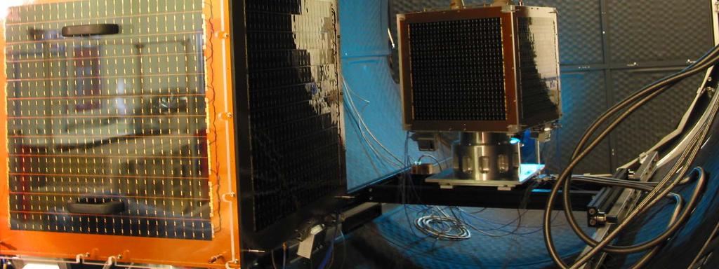
8 UK-DMC Satellite and Bistatic GPS Experiment SSTL and BNSC funding UK-DMC satellite Launched Sept km altitude sunsynchronous orbit Reflectometry Antenna Imager During pre-launch thermal vacuum testing, with NigeriaSat-1 Earth facing facet, with LHCP, 12 dbic gain antenna
 To receive the direct GPS signal Placed to have GPS satellite in Fieldof-regard LNA LNA SGR RF Front- End 1,2,3 SGR RF Front-End 4 Sign Mag 5.")
9 Payload SSTL SGR10/20 GPS receiver One high-gain antenna Left Hand Circular polarisation Specially built for the purpose dbi needed Compensates for reflected signal loss One regular antenna (minimum) To receive the direct GPS signal Placed to have GPS satellite in Fieldof-regard LNA LNA SGR RF Front- End 1,2,3 SGR RF Front-End 4 Sign Mag 5.71 MHz SGR Digital Real Time Processing Section Solid Solid State State Data Recorder Data Recorder & OBC and OBC CISCO Router Solid State Data Recorder and OBC PVT & Processed Data from RF2 CAN Bus High speed bus Sampled data Downlink Additional sampling On-Board computer stores data A few seconds of data sampled Currently about one minute maximum
10 Ocean Roughness Sensing
11 Transmit power & gain Received power Calculation of Normalised Radar Cross Section (sigma0) σ0 represents scattering gain towards the receiver in bistatic radar equation: Receive gain P R = P G 2 T Txλ σ 0GRx 4 Rx Tx ( π ) R R Paths before and after reflection Equation expanded by Zavorotney and Voronovich to include GPS code and Doppler terms. Re-arranging gives us our estimated value: ˆ σ ( 4π ) 3 Ti PR 0 = 2 P Tλ A 1 G G Tx Rx 2 RRx Λ R 2 S 2 Tx 2 da 1 Code and Doppler terms Surface of integration A, selected as first GPS code chip isorange ellipse on the oceans surface


12 Three Examples Under Different Ocean Conditions Correlation Peak 1 Second Averaging No Signal March 23 rd 2004 Winds ~ 2 m/s March 4 th 2005 Winds 7 m/s September 3rd 2004 Winds 10 m/s


13 November 16 th 2004 Model Waveform Signal in Raw Data
14 Ice and land sensing


15 Signals Detected Off Sea Ice Very strong coherent signals from sea ice Signal power variation with ice thickness UK-DMC Specular Reflection Point 9/10ths ice total concentration, first year thin ice 30-70cm thick

16 Height profile Signal

17 Height profile Signal

18 Height profile Signal
19 Discussion of Land Reflections Signals where easily detectable in all cases, often with only minimum averaging times. The terrain roughness significantly effected the signal magnitude. Flat terrain with sparse vegetation coverage resulted in the strongest signals. Irrespective of surface moisture. The crossing of the Missouri river is clearly identifiable. With proper calibration it may be possible to sense, Surface water or moisture. Terrain types, possibly including human developments. The achievable surface measurement resolution will be critical. Detailed validation work may start next year
20 Measurement Coverage

21 Medium/High Wave Conditions Instantaneous example of reflection opportunities No Signal

22 72 Hour Coverage for a Single Satellite Coverage after 72 hours Denser at higher latitudes Can also add SBAS signals: E.g. EGNOS, WAAS, MSAS Geostationary Adds more equatorial coverage Galileo Glonass

23 Coverage No Signal

24

25 Example of Tracks over One Orbit
26 Summary Earth reflected GPS signals can be easily detected in low Earth orbit from a wide range of surfaces with a medium gain antenna. When reflected from the ocean these signals have been linked to, The surface winds under well developed seas. The surface waves under all conditions. (BRCS and Doppler). GNSS Earth reflected signals are a very promising remote sensing tool for a range of applications. Sensing surface waves and roughness. Sensing surface wave direction. Sensing surface height, tsunamis. Need stronger signals and very accurate models. Sensing sea ice and surface soil moisture. A promising remote sensing technique for small satellite missions


27 Thank You!
Developments in GNSS Reflectometry from the SGR-ReSI on TDS-1
 Changing the economics of space Developments in GNSS Reflectometry from the SGR-ReSI on TDS-1 Martin Unwin Philip Jales, Jason Tye (SSTL), Brent Abbott SST-US Christine Gommenginger, Giuseppe Foti (NOC)
GNSS Remo Sensing in ensin a 6U Cubesat
 GNSS Remote Sensing in a 6U Cubesat Andrew Dempster Remote Sensing using GNSS Radio occultation Well established, with existing missions, v useful for input to weather models Reflectometry Experimental,
Galileo signal reflections used for monitoring waves and weather at sea
 Press Release Monday 26 th November 2007 Galileo signal reflections used for monitoring waves and weather at sea Surrey Satellite Technology Ltd (SSTL) and the University of Surrey have succeeded for the
Preparation for Flight of Next Generation Space GNSS Receivers
 Changing the economics of space Preparation for Flight of Next Generation Space GNSS Receivers ICGPSRO, 14-16 th May 2013 Taiwan #0205691 Commercial in Confidence 1 Overview SSTL and Spaceborne GNSS Small
GNSS-Reflectometry for Observation and Monitoring of Earth surface
 GNSS-Reflectometry for Observation and Monitoring of Earth surface Global Navigation meets Geoinformation ESA ESOC Darmstadt, 28-04-2017 Dr. Ing. Domenico Schiavulli INR engineer support at EUMETSAT Outline
ESA Study GNSS Reflectometry Instrument & Algorithms NCEO/CEOI Conference, 19 th Sept 2012
 Changing the economics of space ESA Study GNSS Reflectometry Instrument & Algorithms NCEO/CEOI Conference, 19 th Sept 2012 #01xxxxx Overview GNSS for Remote Sensing Concept and UK-DMC Experiment Scientific
Earth Remote Sensing using Surface-Reflected GNSS Signals (Part II)
") Jet Propulsion Laboratory California Institute of Technology National Aeronautics and Space Administration Jet Propulsion Laboratory California Institute of Technology Pasadena, California Earth Remote
Jet Propulsion Laboratory California Institute of Technology National Aeronautics and Space Administration Jet Propulsion Laboratory California Institute of Technology Pasadena, California Earth Remote
Theoretical Simulations of GNSS Reflections from Bare and Vegetated Soils
 Theoretical Simulations of GNSS Reflections from Bare and Vegetated Soils R. Giusto 1, L. Guerriero, S. Paloscia 3, N. Pierdicca 1, A. Egido 4, N. Floury 5 1 DIET - Sapienza Univ. of Rome, Rome DISP -
Developments in GNSS-Reflectometry from the SGR-ReSI in orbit on TechDemoSat-1
 SSC16-XII-07 Developments in GNSS-Reflectometry from the SGR-ReSI in orbit on TechDemoSat-1 Martin Unwin, Phil Jales, Jason Tye Surrey Satellite Technology Ltd Tycho House, Surrey Research Park Guildford
CYGNSS Wind Retrieval Performance
 International Ocean Vector Wind Science Team Meeting Kailua-Kona, Hawaii USA 6-8 May 2013 CYGNSS Wind Retrieval Performance Chris Ruf (1), Maria-Paola Clarizia (1,2), Andrew O Brien (3), Joel Johnson (3),
Recent GNSS Reflectometry Results from the UK TDS-1 Satellite
 CHANGING THE ECONOMICS OF SPACE Recent GNSS Reflectometry Results from the UK TDS-1 Satellite Martin Unwin ICGPSRO2018, Taipei, 18-20 April 2018 SSTL 2018 Ack: SSTL, NOC, ESA, Surrey, CEOI, UKSA, InnovateUK,
Remote Sensing with Reflected Signals
 Remote Sensing with Reflected Signals GNSS-R Data Processing Software and Test Analysis Dongkai Yang, Yanan Zhou, and Yan Wang (airplane) istockphoto.com/mark Evans; gpsiff background Authors from a leading
Soil Moisture Observation Utilizing Reflected GNSS Signals
 Soil Moisture Observation Utilizing Reflected GNSS Signals GNSS-R Tech in Soil Moisture New Data Processing Method Prof. Dongkai YANG Joint African/Asia-Pacific UN-Regional Centers and International Training
2 INTRODUCTION TO GNSS REFLECTOMERY
 2 INTRODUCTION TO GNSS REFLECTOMERY 2.1 Introduction The use of Global Navigation Satellite Systems (GNSS) signals reflected by the sea surface for altimetry applications was first suggested by Martín-Neira
Commissioning of the NigeriaSat-2 High Resolution Imaging Mission
 Changing the economics of space Commissioning of the NigeriaSat-2 High Resolution Imaging Mission Phil Davies (presenting) SSTL Francis Chizea - NASRDA Andrew Cawthorne SSTL Andrew Carrel - SSTL Luis Gomes
GNSS Reflections over Ocean Surfaces
 GNSS Reflections over Ocean Surfaces State of the Art F. Soulat CCT Space Reflectometry December 1st 2010 Page n 1 Outline Concept GNSS-R Signal On-going Activities ( Applications) CLS GNSS-R Studies CCT
CYGNSS Mission Update
 International Ocean Vector Wind Science Team Meeting Portland, OR 19-21 May 2015 CYGNSS Mission Update Chris Ruf (1) CYGNSS Principal Investigator Paul Chang (2), Maria Paola Clarizia (1), Scott Gleason
New Technologies for Future EO Instrumentation Mick Johnson
 New Technologies for Future EO Instrumentation Mick Johnson Director of CEOI Monitoring the Earth from Space What data do EO satellites provide? Earth Observation science Operational services Weather,
GNSS remote sensing (GNSS-RS)
") GPS Galileo GLONASS Beidou GNSS remote sensing (GNSS-RS) Shuanggen Jin ( 金双根 ) Shanghai Astronomical Observatory, CAS, Shanghai 200030, China Email: sgjin@shao.ac.cn Website: http://www.shao.ac.cn/geodesy
GPS Galileo GLONASS Beidou GNSS remote sensing (GNSS-RS) Shuanggen Jin ( 金双根 ) Shanghai Astronomical Observatory, CAS, Shanghai 200030, China Email: sgjin@shao.ac.cn Website: http://www.shao.ac.cn/geodesy
GNSS-R for Ocean and Cryosphere Applications
 GNSS-R for Ocean and Cryosphere Applications E.Cardellach and A. Rius Institut de Ciències de l'espai (ICE/IEEC-CSIC), Spain Contents Altimetry with Global Navigation Satellite Systems: Model correlation
OBSERVATION PERFORMANCE OF A PARIS ALTIMETER IN-ORBIT DEMONSTRATOR
 OBSERVATION PERFORMANCE OF A PARIS ALTIMETER IN-ORBIT DEMONSTRATOR Salvatore D Addio, Manuel Martin-Neira Acknowledgment to: Nicolas Floury, Roberto Pietro Cerdeira TEC-ETP, ETP, Electrical Engineering
GNSS Reflectometry and Passive Radar at DLR
 ACES and FUTURE GNSS-Based EARTH OBSERVATION and NAVIGATION 26./27. May 2008, TU München Dr. Thomas Börner, Microwaves and Radar Institute, DLR Overview GNSS Reflectometry a joined proposal of DLR and
Prototype Software-based Receiver for Remote Sensing using Reflected GPS Signals. Dinesh Manandhar The University of Tokyo
 Prototype Software-based Receiver for Remote Sensing using Reflected GPS Signals Dinesh Manandhar The University of Tokyo dinesh@qzss.org 1 Contents Background Remote Sensing Capability System Architecture
A NANOSATELLITE TO DEMONSTRATE GPS OCEANOGRAPHY REFLECTOMETRY
 A NANOSATELLITE TO DEMONSTRATE GPS OCEANOGRAPHY REFLECTOMETRY Maarten Meerman, Dr. Martin Unwin, Scott Gleason, Dr. Susan Jason, Prof. Sir Martin Sweeting Surrey Satellite Technology Limited Surrey Space
3D Multi-static SAR System for Terrain Imaging Based on Indirect GPS Signals
 Journal of Global Positioning Systems (00) Vol. 1, No. 1: 34-39 3D Multi-static SA System for errain Imaging Based on Indirect GPS Signals Yonghong Li, Chris izos School of Surveying and Spatial Information
PARIS Ocean Altimeter
 PARIS Ocean Altimeter M. Martín-Neira, S. D Addio (TEC-ETP) European Space Agency Acknowledgment: C. Buck (TEC-ETP) N. Floury, R. Prieto (TEC-EEP) GNSS-R10 Workshop, UPC, Barcelona, 21-22 October 2010
Nigerian Communications Satellite Ltd. (NIGCOMSAT)
") OVERVIEW OF NIGERIAN SATELLITE AUGMENTATION SYSTEM COMMENCING WITH PILOT DEMONSTRATION TO VALIDATE NATIONAL WORK PLAN presented by Dr. Lawal Lasisi Salami, NIGERIAN COMMUNICATIONS SATELLITE LTD UNDER FEDERAL
OVERVIEW OF NIGERIAN SATELLITE AUGMENTATION SYSTEM COMMENCING WITH PILOT DEMONSTRATION TO VALIDATE NATIONAL WORK PLAN presented by Dr. Lawal Lasisi Salami, NIGERIAN COMMUNICATIONS SATELLITE LTD UNDER FEDERAL
Remote Sensing using Bistatic GPS and a Digital Beam Steering Receiver
 Remote Sensing using Bistatic GPS and a Digital Beam Steering Receiver Alison Brown and Ben Mathews, NAVSYS Corporation BIOGRAPHY Alison Brown is the President and Chief Executive Officer of NAVSYS Corporation.
Active microwave systems (1) Satellite Altimetry
 Satellite Altimetry") Remote Sensing: John Wilkin Active microwave systems (1) Satellite Altimetry jwilkin@rutgers.edu IMCS Building Room 214C 732-932-6555 ext 251 Active microwave instruments Scatterometer (scattering from
Remote Sensing: John Wilkin Active microwave systems (1) Satellite Altimetry jwilkin@rutgers.edu IMCS Building Room 214C 732-932-6555 ext 251 Active microwave instruments Scatterometer (scattering from
Outline. GPS RO Overview. COSMIC Overview. COSMIC-2 Overview. Summary 9/29/16
 Bill Schreiner and UCAR/COSMIC Team UCAR COSMIC Program Observation and Analysis Opportunities Collaborating with the ICON and GOLD Missions Sept 27, 216 GPS RO Overview Outline COSMIC Overview COSMIC-2
The signals from the GPS constellation
 INNOVATION Remote Sensing Reflecting on GPS Sensing Land and Ice from Low Earth Orbit Scott T. Gleason GPS IS NOT YOUR PARENTS POSITIONING SYSTEM. Today, GPS is being used in a variety of unconventional
Remote Sensing: John Wilkin IMCS Building Room 211C ext 251. Active microwave systems (1) Satellite Altimetry
 Satellite Altimetry") Remote Sensing: John Wilkin wilkin@marine.rutgers.edu IMCS Building Room 211C 732-932-6555 ext 251 Active microwave systems (1) Satellite Altimetry Active microwave instruments Scatterometer (scattering
Remote Sensing: John Wilkin wilkin@marine.rutgers.edu IMCS Building Room 211C 732-932-6555 ext 251 Active microwave systems (1) Satellite Altimetry Active microwave instruments Scatterometer (scattering
PARIS In-Orbit Demonstrator
 1/52 PARIS In-Orbit Demonstrator Manuel Martín-Neira Neira,, Salvatore D Addio,, Christopher Buck (TEC-ETP) ETP) Acknowledgments: F. Coromina (TEC-ETP) ETP) N. Floury (TEC-EEP) EEP) J. Santiago Prowald
Passive Microwave Sensors LIDAR Remote Sensing Laser Altimetry. 28 April 2003
 Passive Microwave Sensors LIDAR Remote Sensing Laser Altimetry 28 April 2003 Outline Passive Microwave Radiometry Rayleigh-Jeans approximation Brightness temperature Emissivity and dielectric constant
GEROS-ISS: GNSS REflectometry, Radio Occultation and Scatterometry onboard the International Space Station
 GEROS-ISS: GNSS REflectometry, Radio Occultation and Scatterometry onboard the International Space Station J. Wickert, O. Andersen, L. Bertino, A. Camps, E. Cardellach, B. Chapron, C. Gommenginger, J.
Arctic Navigation Issues. e-nav conference Nordic Institute of Navigation Bergen, March 5 th 2009
 Arctic Navigation Issues e-nav conference Nordic Institute of Navigation Bergen, March 5 th 2009 by Anna B.O. Jensen - AJ Geomatics Jean-Paul Sicard - Rovsing A/S March 2009 1 Outline Reduction of ice
Challenges and Solutions for GPS Receiver Test
 Challenges and Solutions for GPS Receiver Test Presenter: Mirin Lew January 28, 2010 Agenda GPS technology concepts GPS and GNSS overview Assisted GPS (A-GPS) Basic tests required for GPS receiver verification
Analysis of GNSS-R delay-doppler maps from the UK-DMC satellite over the ocean
 Click Here for Full Article GEOPHYSICAL RESEARCH LETTERS, VOL. 36, L02608, doi:10.1029/2008gl036292, 2009 Analysis of GNSS-R delay-doppler maps from the UK-DMC satellite over the ocean M. P. Clarizia,
Introduction Active microwave Radar
 RADAR Imaging Introduction 2 Introduction Active microwave Radar Passive remote sensing systems record electromagnetic energy that was reflected or emitted from the surface of the Earth. There are also
The topic we are going to see in this unit, the global positioning system, is not directly related with the computer networks we use everyday, but it
 The topic we are going to see in this unit, the global positioning system, is not directly related with the computer networks we use everyday, but it is indeed a kind of computer network, as the specialised
CYCLONE GLOBAL NAVIGATION SATELLITE SYSTEM (CYGNSS)
") CYCLONE GLOBAL NAVIGATION SATELLITE SYSTEM (CYGNSS) Algorithm Theoretical Basis Document Level 1B DDM Calibration UM Doc. No. 148-0137-X1 SwRI Doc. No. N/A Revision 1 Date 19 December 2014 Contract NNL13AQ00C
CYCLONE GLOBAL NAVIGATION SATELLITE SYSTEM (CYGNSS) Algorithm Theoretical Basis Document Level 1B DDM Calibration UM Doc. No. 148-0137-X1 SwRI Doc. No. N/A Revision 1 Date 19 December 2014 Contract NNL13AQ00C
Microwave Remote Sensing
 Provide copy on a CD of the UCAR multi-media tutorial to all in class. Assign Ch-7 and Ch-9 (for two weeks) as reading material for this class. HW#4 (Due in two weeks) Problems 1,2,3 and 4 (Chapter 7)
The Typhoon Investigation using GNSS-R Interferometric Signals (TIGRIS)
") The Typhoon Investigation using GNSS-R Interferometric Signals (TIGRIS) F. Fabra 1, W. Li 2, M. Martín-Neira 3, S. Oliveras 1, A. Rius 1, W. Yang 2, D. Yang 2 and Estel Cardellach 1 1 Institute of Space
The Typhoon Investigation using GNSS-R Interferometric Signals (TIGRIS) F. Fabra 1, W. Li 2, M. Martín-Neira 3, S. Oliveras 1, A. Rius 1, W. Yang 2, D. Yang 2 and Estel Cardellach 1 1 Institute of Space
Test Results from a Novel Passive Bistatic GPS Radar Using a Phased Sensor Array
 Test Results from a Novel Passive Bistatic GPS Radar Using a Phased Sensor Array Alison Brown and Ben Mathews, NAVSYS Corporation BIOGRAPHY Alison Brown is the Chief Visionary Officer of NAVSYS Corporation.
ELECTROMAGNETIC PROPAGATION (ALT, TEC)
") ELECTROMAGNETIC PROPAGATION (ALT, TEC) N. Picot CNES, 18 Av Ed Belin, 31401 Toulouse, France Email : Nicolas.Picot@cnes.fr ABSTRACT For electromagnetic propagation, the ionosphere plays a key role. This
ELECTROMAGNETIC PROPAGATION (ALT, TEC) N. Picot CNES, 18 Av Ed Belin, 31401 Toulouse, France Email : Nicolas.Picot@cnes.fr ABSTRACT For electromagnetic propagation, the ionosphere plays a key role. This
The last 25 years - GPS to multi-gnss: from a military tool to the most widely used civilian positioning solution
 1 The last 25 years - GPS to multi-gnss: from a military tool to the most widely used civilian positioning solution B. Hofmann-Wellenhof Institute of Geodesy / Navigation, Graz University of Technology
GNSS Reflectometry: Innovative Remote Sensing
 GNSS Reflectometry: Innovative Remote Sensing J. Beckheinrich 1, G. Beyerle 1, S. Schön 2, H. Apel 1, M. Semmling 1, J. Wickert 1 1.GFZ, German Research Center for Geosciences, Potsdam, Germany 2.Leibniz
GNSS Reflectometry at GFZ
 GNSS Reflectometry at GFZ Achim Helm, Georg Beyerle, Ralf Stosius, Markus Rothacher (GFZ) External Partners and Contributors: Oliver Montenbruck (DLR), Estel Cardellach, Antonio Rius (IEEC), Sergei Yudanov,
GPS (Introduction) References. Terms
 References. Terms") GPS (Introduction) WCOM2, GPS, 1 Terms NAVSTAR GPS ( Navigational Satellite Timing and Ranging - Global Positioning System) is a GNSS (Global Navigation Satellite System), developed by the US-DoD in 197x
GPS (Introduction) WCOM2, GPS, 1 Terms NAVSTAR GPS ( Navigational Satellite Timing and Ranging - Global Positioning System) is a GNSS (Global Navigation Satellite System), developed by the US-DoD in 197x
GNSS Remote Sensing: CubeSat case study
 GNSS Remote Sensing: CubeSat case study P-GRESSION system and its background at PoliTo CubeSat Team Lorenzo Feruglio PhD student, Aerospace Engineering LIST OF ACRONYMS LIST OF FIGURES Introduction GNSS
RAPID DEVELOPMENT OF NAVIGATION PAYLOADS FOR GALILEO FULL OPERATIONAL CAPABILITY
 Changing the economics of space RAPID DEVELOPMENT OF NAVIGATION PAYLOADS FOR GALILEO FULL OPERATIONAL CAPABILITY Alex da Silva Curiel Dubai, January 2011 SSTL - the company UK-based satellite manufacturing
GNSS-R for studies of the cryosphere
 GNSS-R for studies of the cryosphere F. Fabra 1, E. Cardellach 1, O. Nogués-Correig 1, S. Oliveras 1, S. Ribó 1, J.C. Arco 1, A. Rius 1, M. Belmonte-Rivas 2, M. Semmling 3, G. Macelloni 4, S. Pettinato
On the Achievable Accuracy for Estimating the Ocean Surface Roughness using Multi-GPS Bistatic Radar
 On the Achievable Accuracy for Estimating the Ocean Surface Roughness using Multi-GPS Bistatic Radar Nima Alam, Kegen Yu, Andrew G. Dempster Australian Centre for Space Engineering Research (ACSER) University
Rec. ITU-R P RECOMMENDATION ITU-R P *
 Rec. ITU-R P.682-1 1 RECOMMENDATION ITU-R P.682-1 * PROPAGATION DATA REQUIRED FOR THE DESIGN OF EARTH-SPACE AERONAUTICAL MOBILE TELECOMMUNICATION SYSTEMS (Question ITU-R 207/3) Rec. 682-1 (1990-1992) The
Design and Performance Simulation of a Ku-Band Rotating Fan-Beam Scatterometer
 Design and Performance Simulation of a Ku-Band Rotating Fan-Beam Scatterometer Xiaolong DONG, Wenming LIN, Di ZHU, (CSSAR/CAS) PO Box 8701, Beijing, 100190, China Tel: +86-10-62582841, Fax: +86-10-62528127
Microsatellite Ionospheric Network in Orbit
 Changing the economics of space Microsatellite Ionospheric Network in Orbit Dr Stuart Eves Lead Mission Concepts Engineer SSTL s.eves@sstl.co.uk In tribute to Mino Freund 1962-2012 Introduction Objective
CALIBRATING GNSS SATELLITE ANTENNA GROUP-DELAY VARIATIONS USING SPACE AND GROUND RECEIVERS
 IGS WORKSHOP 2014 CALIBRATING GNSS SATELLITE ANTENNA GROUP-DELAY VARIATIONS USING SPACE AND GROUND RECEIVERS June 23-27, 2014 - PASADENA, CALIFORNIA Plenary PY06: Infrastructure and Calibration David CALLE
A Solution for Every Application. Trimble GNSS Geodetic Antennas TRANSFORMING THE WAY THE WORLD WORKS
 A Solution for Every Application Trimble GNSS Geodetic Antennas TRANSFORMING THE WAY THE WORLD WORKS Trimble GNSS Geodetic Antennas Trimble geodetic antennas mitigate multipath in different ways. Each
GomSpace Presentation to Hytek Workshop
 GomSpace Presentation to Hytek Workshop Presented by: Lars K. Alminde Managing Director GomSpace Aps alminde@gomspace.com Do not redistribute without permission GomSpace at a Glance University spin-off
Microwave Remote Sensing (1)
") Microwave Remote Sensing (1) Microwave sensing encompasses both active and passive forms of remote sensing. The microwave portion of the spectrum covers the range from approximately 1cm to 1m in wavelength.
Microwave Remote Sensing (1) Microwave sensing encompasses both active and passive forms of remote sensing. The microwave portion of the spectrum covers the range from approximately 1cm to 1m in wavelength.
A GLOBAL ASSESSMENT OF THE RA-2 PERFORMANCE OVER ALL SURFACES
 A GLOBAL ASSESSMENT OF THE RA-2 PERFORMANCE OVER ALL SURFACES Berry, P.A.M., Smith, R.G. & Freeman, J.A. EAPRS Laboratory, De Montfort University, Leicester, LE9 1BH, UK ABSTRACT The EnviSat RA-2 has collected
Sub-Mesoscale Imaging of the Ionosphere with SMAP
 Sub-Mesoscale Imaging of the Ionosphere with SMAP Tony Freeman Xiaoqing Pi Xiaoyan Zhou CEOS Workshop, ASF, Fairbanks, Alaska, December 2009 1 Soil Moisture Active-Passive (SMAP) Overview Baseline Mission
Remote Sensing: John Wilkin IMCS Building Room 211C ext 251. Active microwave systems (1) Satellite Altimetry
 Satellite Altimetry") Remote Sensing: John Wilkin wilkin@marine.rutgers.edu IMCS Building Room 211C 732-932-6555 ext 251 Active microwave systems (1) Satellite Altimetry Active microwave instruments Scatterometer (scattering
Remote Sensing: John Wilkin wilkin@marine.rutgers.edu IMCS Building Room 211C 732-932-6555 ext 251 Active microwave systems (1) Satellite Altimetry Active microwave instruments Scatterometer (scattering
Target Detection Using GPS Signals of Opportunity
 18th International Conference on Information Fusion Washington, DC - July 6-9, 2015 Target Detection Using GPS Signals of Opportunity Maria-Paola Clarizia Atmospheric, Oceanic and Space Sciences University
Experiences with Fugro's Real Time GPS/GLONASS Orbit/Clock Decimeter Level Precise Positioning System
 Return to Session Directory DYNAMIC POSITIONING CONFERENCE October 13-14, 2009 Sensors Experiences with Fugro's Real Time GPS/GLONASS Orbit/Clock Decimeter Level Precise Positioning System Ole Ørpen and
Integrity of Satellite Navigation in the Arctic
 Integrity of Satellite Navigation in the Arctic TODD WALTER & TYLER REID STANFORD UNIVERSITY APRIL 2018 Satellite Based Augmentation Systems (SBAS) in 2018 2 SBAS Networks in 2021? 3 What is Meant by Integrity?
GPS (Introduction) References. Terms
 References. Terms") GPS (Introduction) MSE, Rumc, GPS, 1 Terms NAVSTAR GPS ( Navigational Satellite Timing and Ranging - Global Positioning System) is a GNSS (Global Navigation Satellite System), developed by the US-DoD in
GPS (Introduction) MSE, Rumc, GPS, 1 Terms NAVSTAR GPS ( Navigational Satellite Timing and Ranging - Global Positioning System) is a GNSS (Global Navigation Satellite System), developed by the US-DoD in
A Coherent Bistatic Vegetation Model for SoOp Land Applications: Preliminary Simulation Results
 A Coherent Bistatic Vegetation Model for SoOp Land Applications: Preliminary Simulation Results Mehmet Kurum (1), Manohar Deshpande (2), Alicia T. Joseph (2), Peggy E. O Neill (2), Roger H. Lang (3), Orhan
European Geostationary Navigation Overlay Service (EGNOS) Capability on Sirius 5 Satellite for SES
 Capability on Sirius 5 Satellite for SES") 21 October 2009 SES SIRIUS European Geostationary Navigation Overlay Service (EGNOS) Capability on Sirius 5 Satellite for SES Mike Pavloff, Executive Director, Space Systems/Loral Information included
21 October 2009 SES SIRIUS European Geostationary Navigation Overlay Service (EGNOS) Capability on Sirius 5 Satellite for SES Mike Pavloff, Executive Director, Space Systems/Loral Information included
In this unit we are going to speak about satellite communications. Satellites are useful for connecting to remote areas, or when you want to
 In this unit we are going to speak about satellite communications. Satellites are useful for connecting to remote areas, or when you want to broadcast video or data with minimal infrastructure. A communications
OCEAN SURFACE ROUGHNESS REFLECTOMETRY WITH GPS MULTISTATIC RADAR FROM HIGH-ALTITUDE AIRCRAFT
 OCEAN SURFACE ROUGHNESS REFLECTOMETRY WITH GPS MULTISTATIC RADAR FROM HIGH-ALTITUDE AIRCRAFT VALERY U. ZAVOROTNY 1, DENNIS M. AKOS 2, HANNA MUNTZING 3 1 NOAA/Earth System Research Laboratory/ Physical
CEGEG046 / GEOG3051 Principles & Practice of Remote Sensing (PPRS) 8: RADAR 1
 8: RADAR 1") CEGEG046 / GEOG3051 Principles & Practice of Remote Sensing (PPRS) 8: RADAR 1 Dr. Mathias (Mat) Disney UCL Geography Office: 113, Pearson Building Tel: 7670 05921 Email: mdisney@ucl.geog.ac.uk www.geog.ucl.ac.uk/~mdisney
CEGEG046 / GEOG3051 Principles & Practice of Remote Sensing (PPRS) 8: RADAR 1 Dr. Mathias (Mat) Disney UCL Geography Office: 113, Pearson Building Tel: 7670 05921 Email: mdisney@ucl.geog.ac.uk www.geog.ucl.ac.uk/~mdisney
Trimble Zephyr Geodetic 2 GNSS Antenna. Trimble GNSS-Ti Choke Ring Antenna. Trimble GNSS Choke Ring Antenna. Specifications
 Trimble GNSS GEODETIC ANTENNAS A SOLUTION FOR EVERY APPLICATION The choice is yours. Trimble provides three GNSS antennas for geodetic applications. Both solutions deliver long term performance with proven
Global Navigation Satellite Systems (GNSS)
") Global Navigation Satellite Systems (GNSS) Pat Norris MRAeS, FRIN LogicaCMG Business Development Manager Chairman, RAeS Space Group LogicaCMG 2006. All rights reserved 2 Global Navigation Satellite Systems
Global Navigation Satellite Systems (GNSS) Pat Norris MRAeS, FRIN LogicaCMG Business Development Manager Chairman, RAeS Space Group LogicaCMG 2006. All rights reserved 2 Global Navigation Satellite Systems
Ocean SAR altimetry. from SIRAL2 on CryoSat2 to Poseidon-4 on Jason-CS
 Ocean SAR altimetry from SIRAL2 on CryoSat2 to Poseidon-4 on Jason-CS Template reference : 100181670S-EN L. Phalippou, F. Demeestere SAR Altimetry EGM NOC, Southampton, 26 June 2013 History of SAR altimetry
Pulse-Pair (Doppler) Processing of Envisat Individual Echoes
 Processing of Envisat Individual Echoes") Pulse-Pair (Doppler) Processing of Envisat Individual Echoes R. Abileah 1, S. Vignudelli 2 1 jomegak, San Carlos CA, USA 2 CNR Istituto di Biofisica, Pisa, Italy Outline Envisat individual echoes (IE)
Pulse-Pair (Doppler) Processing of Envisat Individual Echoes R. Abileah 1, S. Vignudelli 2 1 jomegak, San Carlos CA, USA 2 CNR Istituto di Biofisica, Pisa, Italy Outline Envisat individual echoes (IE)
Interferometric Cartwheel 1
 The Interferometric CartWheel A wheel of passive radar microsatellites for upgrading existing SAR projects D. Massonnet, P. Ultré-Guérard (DPI/EOT) E. Thouvenot (DTS/AE/INS/IR) Interferometric Cartwheel
Future Concepts for Galileo SAR & Ground Segment. Executive summary
 Future Concepts for Galileo SAR & Ground Segment TABLE OF CONTENT GALILEO CONTRIBUTION TO THE COSPAS/SARSAT MEOSAR SYSTEM... 3 OBJECTIVES OF THE STUDY... 3 ADDED VALUE OF SAR PROCESSING ON-BOARD G2G SATELLITES...
Dimov Stojče Ilčev. CNS Systems
 Stratospheric Platform Systems (SPS) Presentation by: Dimov Stojče Ilčev Durban University of Technology (DUT) Space Science Centre (SSC) CNS Systems August 2011 SPS for Mobile CNS Applications Stratospheric
GNSS Programme. Overview and Status in Europe
 GNSS Programme Overview and Status in Europe Inaugural Forum Satellite Positioning Research and Application Center 23 April 2007 Tokyo Presented by Thomas Naecke (European Commission) Prepared by Daniel
IEEE TRANSACTIONS ON GEOSCIENCE AND REMOTE SENSING 1
 IEEE TANSACTIONS ON GEOSCIENCE AND EMOTE SENSING 1 Calibration and Unwrapping of the Normalized Scattering Cross Section for the Cyclone Global Navigation Satellite System Scott Gleason, Senior Member,
TanDEM-X. 1. Mission Overview. Science Meeting No SAR Imaging Modes & Performance 3. Satellite Design Overview 4. Launcher 5.
 TanDEM-X Science Meeting No. 1 Dresden 15.5.2006 Wolfgang Pitz EADS Astrium GmbH D-88039 Friedrichshafen 1. Mission Overview 2. SAR Imaging Modes & Performance 3. Satellite Design Overview 4. Launcher
Microwave Sensors Subgroup (MSSG) Report
 Report") Microwave Sensors Subgroup (MSSG) Report CEOS WGCV-35 May 13-17, 2013, Shanghai, China DONG, Xiaolong, MSSG Chair CAS Key Laboratory of Microwave Remote Sensing National Space Science Center Chinese Academy
Microwave Sensors Subgroup (MSSG) Report CEOS WGCV-35 May 13-17, 2013, Shanghai, China DONG, Xiaolong, MSSG Chair CAS Key Laboratory of Microwave Remote Sensing National Space Science Center Chinese Academy
GNSS in the Arctic. by Arne Rinnan, Kongsberg Seatex AS. WORLD CLASS through people, technology and dedication
 GNSS in the Arctic by Arne Rinnan, Kongsberg Seatex AS WORLD CLASS through people, technology and dedication Outline Introduction Weather conditions Satellite coverage Aurora impact GNSS corrections Test
Ionospheric H-Atom Tomography: a Feasibility Study using GNSS Reflections. G. Ruffini, Josep Marco, L. Ruffini ESTEC, Dec 17th 2002
 Ionospheric H-Atom Tomography: a Feasibility Study using GNSS Reflections. G. Ruffini, Josep Marco, L. Ruffini ESTEC, Dec 17th 2002 Goals of the GIOS-1 study ESTEC Tech Officer: Bertram Arbesser-Rastburg
Microwave Sensors Subgroup (MSSG) Report
 Report") Microwave Sensors Subgroup (MSSG) Report Feb 17-20, 2014, ESA ESRIN, Frascati, Italy DONG, Xiaolong, MSSG Chair National Space Science Center Chinese Academy of Sciences (MiRS,NSSC,CAS) Email: dongxiaolong@mirslab.cn
Microwave Sensors Subgroup (MSSG) Report Feb 17-20, 2014, ESA ESRIN, Frascati, Italy DONG, Xiaolong, MSSG Chair National Space Science Center Chinese Academy of Sciences (MiRS,NSSC,CAS) Email: dongxiaolong@mirslab.cn
Waveform Processing of Nadir-Looking Altimetry Data
 Waveform Processing of Nadir-Looking Altimetry Data Mònica Roca and Richard Francis ESA/ESTEC Noordwijk The Netherlands Contents 1. the concept 2. introduction 3. the on-board waveform [how the return
Enhancing space situational awareness using passive radar from space based emitters of opportunity
 Tracking Space Debris Craig Benson School of Engineering and IT Enhancing space situational awareness using passive radar from space based emitters of opportunity Space Debris as a Problem Debris is fast
Specificities of Near Nadir Ka-band Interferometric SAR Imagery
 Specificities of Near Nadir Ka-band Interferometric SAR Imagery Roger Fjørtoft, Alain Mallet, Nadine Pourthie, Jean-Marc Gaudin, Christine Lion Centre National d Etudes Spatiales (CNES), France Fifamé
NCUBE: The first Norwegian Student Satellite. Presenters on the AAIA/USU SmallSat: Åge-Raymond Riise Eystein Sæther
 NCUBE: The first Norwegian Student Satellite Presenters on the AAIA/USU SmallSat: Åge-Raymond Riise Eystein Sæther Motivation Build space related competence within: mechanical engineering, electronics,
Design of an Airborne SLAR Antenna at X-Band
 Design of an Airborne SLAR Antenna at X-Band Markus Limbach German Aerospace Center (DLR) Microwaves and Radar Institute Oberpfaffenhofen WFMN 2007, Markus Limbach, Folie 1 Overview Applications of SLAR
SAR Formation Flying
 3 th June 13 SAR Formation Flying Annex 4. Bistatic Sensor Experiment Document Version: v1_1 Dr. Kegen Yu, Prof. Chris Rizos & Prof. Andrew Dempster Australian Centre for Space Engineering Research (ACSER)
Satellite Laser Retroreflectors for GNSS Satellites: ILRS Standard
 Satellite Laser Retroreflectors for GNSS Satellites: ILRS Standard Michael Pearlman Director Central Bureau International Laser Ranging Service Harvard-Smithsonian Center for Astrophysics Cambridge MA
S a t e l l i t e T i m e a n d L o c a t i o n. N o v e m b e r John Fischer VP Advanced R&D
 STL - S a t e l l i t e T i m e a n d L o c a t i o n N o v e m b e r 2 0 1 7 John Fischer VP Advanced R&D jfischer@orolia.com 11/28/201 1 7 WHY AUGMENT GNSS? Recent UK Study Economic Input to UK of a
Deriving meteorological observations from intercepted Mode-S EHS messages.
 Deriving meteorological observations from intercepted Mode-S EHS messages. Edmund Keith Stone and Malcolm Kitchen July 28, 2016 Abstract The Met Office has deployed a network of five receivers in the UK
One Source for Positioning Success
 novatel.com One Source for Positioning Success RTK, PPP, SBAS OR DGNSS. NOVATEL CORRECT OPTIMIZES ALL CORRECTION SOURCES, PUTTING MORE POWER, FLEXIBILITY AND CONTROL IN YOUR HANDS. NovAtel CORRECT is the
Canadian Space Agency program update
 Canadian Space Agency program update Briefing to the meeting of the Expert Team on Satellite Systems (ET-SAT-11) Geneva, 4 April 2017 Guennadi Kroupnik Canadian Space Agency RADARSAT-2: CURRENT OPERATIONAL
RFTSAT: Cassie Wade Northwest Nazarene University
 RFTSAT: Demonstrating Passive RF Sensor Tags Using Backscatter Data Communication Cassie Wade Northwest Nazarene University Daniel Slemmer, Curtis Garner, Lucas Schamber, Jordan Poundstone, Brandon Pankey
GNSS-R for Land Bio-Geophysical Parameters Monitoring: the LEiMON Project
 GNSS-R for Land Bio-Geophysical Parameters Monitoring: the LEiMON Project Alejandro Egido(1), Marco Caparrini(1), Leila Guerriero(2), Nazzareno Pierdicca(2), Simonetta Paloscia(3), Marco Brogioni(3), Nicolas
3/31/03. ESM 266: Introduction 1. Observations from space. Remote Sensing: The Major Source for Large-Scale Environmental Information
 Remote Sensing: The Major Source for Large-Scale Environmental Information Jeff Dozier Observations from space Sun-synchronous polar orbits Global coverage, fixed crossing, repeat sampling Typical altitude