Future Concepts for Galileo SAR & Ground Segment. Executive summary
|
|
|
- Deborah Ray
- 6 years ago
- Views:
Transcription

1 Future Concepts for Galileo SAR & Ground Segment
2 TABLE OF CONTENT GALILEO CONTRIBUTION TO THE COSPAS/SARSAT MEOSAR SYSTEM... 3 OBJECTIVES OF THE STUDY... 3 ADDED VALUE OF SAR PROCESSING ON-BOARD G2G SATELLITES... 4 THE ADDITION OF ON-BOARD PROCESSING ON GALILEO-2 SATELLITES WOULD BRING 4 ADVANTAGES AND OPPORTUNITIES COMPARED TO THE CURRENT SYSTEM:... 4 SPACE SEGMENT PROCESSING PAYLOAD DESIGN... 5 GROUND SEGMENT GALLUT... 6 GROUND SEGMENT OMNILUT... 7 GROUND SEGMENT - GALLUT AND OMNILUTS... 8 DEVELOPMENT PLAN CONCLUSION ASIC Application Specific Integrated Circuit: high processing capacity component dedicated to one code BDP Burst Data Packet: demodulated distress message burst and associated ancillary data D&E Demonstration & Evaluation: preliminary testing phase in Cospas/Sarsat developments Encoded Beacon position taken from its GNSS receiver (when available) reported in the distress message EQM Evaluation Qualification Model: for SARP, fully representative hardware (including ASIC) for test FGB First Generation Beacons, current beacons waveform FOC Full Operational Capability: date when worldwide MEOSAR coverage is achieved (2020) GALLUT Central ground station processing the messages demodulated by on-board processing payloads Independent Beacon position estimated by the MEOSAR system, using at least 3 satellites LEOSAR Search-and-Rescue satellite system based on LEO satellite, used from 1980 to around 2020 MCC Mission Control Centre: operational interface between MEOLUT and Cospas/Sarsat network MEOLUT MEOSAR processing ground station for current system with SAR repeater payloads MEOSAR Search-and-Rescue satellite system based on MEO satellites (Galileo, Glonass, GPS) Networking Capability of ground stations to exchange measurements on beacon bursts OMNILUT Local ground station receiving the messages demodulated by on-board processing payloads PFM Proto-Flight Model: used for in-orbit payload and GALLUT/OMNILUT testing during D&E SGB Second Generation Beacons, specifically developed for MEOSAR, with spread-spectrum SIT Subject Indicator Type: format used for exchange between Cospas/Sarsat ground elements Major acronyms and terms for MEOSAR context
3 Galileo contribution to the Cospas/Sarsat MEOSAR system The Cospas/Sarsat MEOSAR system entered operation phase the 13 th of December 2016, thanks to the availability of 3 MEOSAR ground stations called MEOLUTs (the French one developed by Thales Alenia Space and the two US ones), and thanks to a sufficient number of satellites. In the coming months, the system will be extended to reach a worldwide coverage and enter Full Operational Capability (FOC), thanks to the addition of operational satellites and MEOLUTs. The FOC is to be declared in 2019: at this date, the space segment of the system will be based for 75% on Galileo satellites. Also considering the ICAO requirement for deploying in-flight activated beacons on all new commercial aircrafts from January 2021, this indirectly brings a major role for Galileo in worldwide aviation safety and security. Galileo is then the main support of the Cospas/Sarsat system today and for the next years. In addition, Galileo is also providing an additional innovative service with its Return-Link capability. Today, the Return-Link Service is mainly intended to send acknowledgment messages, but other uses are also considered in the near future (such as remote activation in aviation to manage aircraft disappearances), which may lead to new specification on the Galileo SAR service. Objectives of the study While the MEOSAR is moving to FOC with Galileo satellites that are equipped with SAR transparent payloads, ESA is already investigating its future Galileo-2 (G2G) system for new features. In this framework, one of the aims of the ESA study on Future Concepts for Galileo Search And Rescue was to define a preliminary design of a new SAR payload capable of processing both First Generation Beacon (FGB) and future Second Generation Beacon (SGB) signals. The purpose of the ESA study was also to analyse various communication architectures to transmit the signals back to the Earth, and to assess the overall system performance. The study has been conducted with the following drivers and constraints : the existing MEOSAR service, based on a space segment with SAR transparent payloads, will be operational for the next 15 years. Galileo-2 will still be contributing to the Cospas/Sarsat MEOSAR system and will then maintain its transparent payloads in line with the Cospas/Sarsat system requirements and needs; thanks to the improved location performances and miniaturization of beacons, the Cospas/Sarsat service is going to be adopted by more and more people all around the world, leading to an increased traffic in the next decade. The future SAR payload will have to take into account this increased flow. the new on-board processing function shall minimize the impacts on Galileo and Cospas/Sarsat systems, and on Galileo satellites. In particular, the delivery of messages will have to use the existing Galileo or Cospas/Sarsat telemetry channels. The cost and effects of both the payload and the ground segment will have to be reduced.
4 Added value of SAR processing on-board G2G satellites The addition of on-board processing on Galileo-2 satellites would bring 4 advantages and opportunities compared to the current system: Worldwide homogeneous performance. With a SAR transparent payload, the quality of both the distress detection and localization depend on the closest MEOLUTs. Even if there are minimum commissioning requirements, past tests have shown that performance varies from one MEOLUT to another. In addition, the performance is not homogeneous because each country owning a MEOLUT establishes a minimum coverage area corresponding to its rescue area, where the performance shall be optimized. Even if other regions around this rescue area are also simultaneously covered thanks to the large MEO satellite footprints, the quality of localization in these regions is not verified during commissioning and is then expected to be degraded. Improved accuracy. In the current system, a distress alert picked up by a satellite that is not in the field of view of a MEOLUT is lost. With a processing on-board the satellites and a ground centralization of the processed data, all the satellites in the beacon field of view can be used for localization. Taking into account the beacon antenna mask (FGB antennas cannot emit in the zenith direction, whereas future SGB antennas do), this would increase the accuracy by 30%. The accuracy could also be improved by networking MEOLUTs in order to exchange and combine measurements. However, this option is not recommended because this network would be composed of MEOLUTs from different providers, which could make the calibration process more difficult. Return-Link with reduced latency. It could be possible with this on-board processing to implement the Return-Link directly onboard the satellite, with a latency reduced from a few minutes today to a few seconds. This on-board Return-Link concept cannot be generalized because of possible multiple Return- Links by several satellites for the same beacon, and because of operational risks (in case of false detection for instance); however, it might be interesting in specific emergency cases for the delivery of information to surrounding people for instance. Direct downlink of distresses on simplified LUTs. Classical MEOLUTs request high reception capabilities and processing functions (in particular for Second Generation Beacons), as the received distress signal is only transparently forwarded by the SAR payload. With on-board signal processing, ground reception and processing are far less complex. Then, it is possible to deploy simplified LUT stations (called OMNILUT in the study) with reduced cost. OMNILUT could even be transportable and used by rescue teams or other users to get continuous and instantaneous information on distress beacons during search activities.
5 Space segment Processing payload design The use of on-board processing was already implemented in the LEOSAR system. Thales Alenia Space developed the on-board processing of the last generation of SAR processors in the late 1990 s. The implementation of on-board processing for MEOSAR will use the same principle, but with the following modifications: Increase of the number of simultaneously processed beacons, due to a higher traffic and a larger footprint Addition of on-board measurement calibration to ease the ground processing (in particular for OMNILUTs), by exploiting ephemeris that are directly available on-board the satellite Modification of the beacon data packet formats (BDP: Burst Data Packet) to include additional information for MEOSAR, in particular Time Of Arrival measurements Adaptation to Second Generation Beacons (SGBs). This last requirement on SGB processing is important because the acquisition of these beacons is very consuming in terms of processing power, and requires specific hardware on the MEOLUTs that already implement the SGB processing today. For an on-board implementation, taking into account the simplicity of the acquisition function (in terms of number of code lines), the number of models to produce, and the sufficient schedule, an ASIC development will be the preferred option. This leads to an ASIC + processor classical design, which is already used on LEOSAR on-board processing payloads or on satellites with GNSS receivers. The following figures provide the general schemes of the processor function, taking into account the repeater function that will also be implemented in the digital domain for an easier integration and an improved jamming protection. SAR processor SAR processor and repeater Working memory for the software Processing function FGB demodulation SGB demodulation TOA/FOA measurements Beacon message generation (BDP) Storage management Processor Interface TTC Interface TM Non-volatile memory for BOOT code Non-volatile memory for storing the software code and the parameters data base Digital samples ASIC Signal FFT SGB acquisition The implementation of the on-board processing does not require any modification on the RF receiver part: it can be directly re-used from the current Galileo-1 design.


6 Ground segment GALLUT Unique ground station with worldwide coverage Architecture The implementation of a unique ground station (called GALLUT) collecting Burst Data Packets (BDP) transmitted by all G2G SAR payloads will be possible thanks to the use of the Galileo telemetry: with the current solution using classical telemetry ground stations: this is the most simple, but depending on evolutions on TTC system on Galileo-2, there may be some latency and impact on Galileo ground stations for the data delivery to the GALLUT; or with the Inter-Satellite Link (ISL): the data rate for SAR demodulated messages is low compared to current requirements for ISL, so that if an ISL is implemented on Galileo-2, it would be relevant to include in it the SAR data flow. The GALLUT would be connected to a unique Cospas/Sarsat Mission Control Centre (MCC), which will significantly simplify the interface with the Cospas/Sarsat system. The 2 possible architectures (one with ISL and one without ISL) are depicted below: With ISL Without ISL

7 Ground segment OMNILUT Simplified ground station with local coverage Thanks to the reduction of data rate by on-board processing, the link budget for the delivery of BDPs on L-band is much better than the one with a transparent payload. This gain has to be shared between the satellite transmission power and the ground station G/T: then it becomes possible to receive the BDPs with a simple hemispherical antenna. The following figure provides the overall architecture, which preserves the transparent function (the relayed signal and the MEOLUT are still present). Depending on the number of satellites in common visibility of the beacon and the OMNILUT, an independent localization (i.e. only using Cospas/Sarsat satellite reception) can be achieved by the OMNILUT with three or more satellites. Otherwise, it shall rely on the capability of the beacon to get a location from its internal GNSS receiver and to include it in the emitted signal (encoded position). The data could be downlinked in the part of the L-band already used by Cospas/Sarsat, or in another telemetry band. The first option seems the most simple and can be efficiently combined with agallut, but if other channels are opened on Galileo-2 for telemetry, in particular to specific types of users, the possibility to add the BDP flow in it should also be considered. If the L-band is used, the simultaneous reception of signals from different Galileo satellites can be solved with various solutions, among which the Code Division Multiple Access technique is the preferred one. It could use the same code length than for SGB signals (38400 chips/s) for an easier consistency and implementation in Cospas/Sarsat. It might be delivered for instance in the MHz MHz band.
8 Ground segment Expected performance The maps on the next page compare the positioning accuracy of FGBs (left column) and SGBs (right column) for a MEOLUT, an OMNILUT and a GALLUT, all placed in Toulouse. The colour code of the figures goes from blue (min value) to red (max value) as follows: - For FGBs : [0 km - 5 km] - For SGBs : [0 m 300 m] There is no localisation possible in deep blue zones. Because the GALLUT is connected to ground stations located all around the Earth, it has constantly access to BDPs transmitted by all Galileo satellites. Therefore, the positioning is very accurate everywhere. The OMNILUT coverage and positioning accuracy are slightly smaller than the ones for a MEOLUT, especially for FGBs which do not emit above 60 (limited antenna pattern). Indeed, an OMNILUT does not have access to GPS and GLONASS satellites, so that the minimum of three satellites in common visibility of the beacon and the OMNILUT is less often reached. To cope with this reduced OMNILUT coverage, three solutions can be investigated: Increase the number of stations, knowing that an OMNILUT will still be less expensive Implement networking (measurements exchange), but it requires a worldwide connectivity Use the OMNILUT as a local add-on/improvement, in complement with a GALLUT


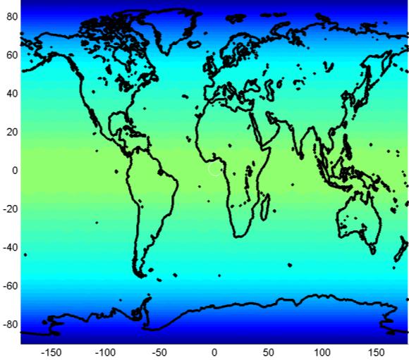
9 MEOLUT with active antennas FGB MEOLUT with active antennas SGB OMNILUT FGB OMNILUT - SGB GALLUT FGB GALLUT - SGB Positioning accuracy maps
 To implement a direct downlink of on-board processed data in L-band, in the Cospas/Sarsat band, with")
10 Ground segment Recommended architecture The recommended solution is then to maintain/implement 3 types of downlinks (see the figure below): (1) To maintain the transparent capacity and the MEOLUT implementation as it is today, to maintain contribution of Galileo to the Cospas/Sarsat system (2) To implement a direct downlink of on-board processed data in L-band, in the Cospas/Sarsat band, with a CDMA approach for multi-access and a link budget compatible with OMNILUT. (3) To implement a worldwide downlink system inside Galileo, delivering all data to a single station (GALLUT) connected to Cospas/Sarsat. This ensures the homogeneous coverage with optimum accuracy. This delivery should use the Galileo telemetry system, either with an Inter-Satellite Link or not. In terms of impact for the system, the L-band transmission power required for data delivery to an MEOLUT/OMNILUT is negligible compared to the transmission power for the repeater, and the telemetry transmission to GALLUT is negligible compared to other considered telemetry data flows for Galileo-2. Therefore, this number of various links does not appear critical while significantly improving the service.
11 Development plan The main driver of the development plan is the ASIC that has to be implemented in the processing payload to process SGBs. The development can be anticipated, but it seems reasonable for the final definition to wait for the start of exploitation of these SGBs inside Cospas/Sarsat, which is expected in From this date, a duration of 24 months is considered for the finalization of the ASIC, its integration and validation inside the EQM, which leads to a final payload qualification in From this date, the flight models can be produced quite rapidly, if required by the Galileo program. As soon as possible, it would be interesting to launch a first satellite with this payload. Indeed, this would allow the final implementation and validation of GALLUT and OMNILUT functions (similarly to a Cospas/Sarsat Demonstration & Evaluation phase), and if possible updates of MEOLUTs for reception of the direct signal. One particular interest of the GALLUT is that it can provide distress information with only one equipped Galileo satellite (only with encoded position, similarly to a GEOLUT), and have a continuous increase of the service quality with the addition of new satellites. There is no major technical risks for the development, which could be done both for board and ground components using current technologies, with only a focus on the ASIC even if the number of code lines is low (parallel acquisition function with Fast Fourier Transform). The main point to analyse for the development will be the evolutions and interfaces with the Galileo-2 downlink system, in particular for the delivery of data to the GALLUT. For this reason, it will be crucial to have a finalized system design for the SAR processor function, and in particular to provide all the beacon models and associated data rate volumes as input for the design of Galileo-2 overall telemetry system. Possible impacts of latency and associated recommendations for the system design shall also be taken into account. A safe development plan could then be implemented as follows: Element Cospas/Sarsat SGB Final definition Exploitation SARP development PDR CDR ASIC and EQM PFM Flight models In-orbit testing (D&E) D&E GALLUT/OMNILUT Development Exploitation Galileo-2 Galileo TTC Design Development With this schedule, the Initial Operational Capability (IOC) could be decided in 2025, and the Full Operational Capability (FOC) as soon as the number of Galileo-2 satellites is sufficient.
12 Conclusion The study has led to the definition of a beacon traffic model for 2025 including SGBs, a preliminary payload design, and first level description and specification of the system. These activities have shown the feasibility and the schedule compatibility of such an initiative, raising in particular the question of the ASIC development for the acquisition of SGBs, but this development does not seem a major constraint if the program is started in line with the Cospas/Sarsat and Galileo-2 developments. The study has thus shown the interest and the feasibility of the addition of on-board SAR processing capacity on future Galileo satellites, complementary to the transparent function. The use of such a SAR payload mainly opens two major system improvements: the availability of a worldwide homogeneous reception capacity with higher accuracy than minimum Cospas/Sarsat requirements, with only one ground station (GALLUT). The latency would depend on the Galileo-2 telemetry architecture, but it could be very limited if an Inter- Satellite Link or an improved Telemetry network is implemented; the availability of a direct local downlink capability, possibly in L-band, for reception by simple ground receivers like omnidirectional antennas linked to laptops. This could help for the dissemination of message updates and the coordination of rescue services. In both cases (worldwide Telemetry and local L-band SAR transmission), the data rates and associated transmission power are low compared to the sizing of the other services: their impact to the current design would then be low. Furthermore, this initiative could thus maintain Galileo as a major contributor and innovation driver in the worldwide Cospas/Sarsat Search-And-Rescue system.
The Future of Search & Rescue. We Save Lives. Steve Waters SAFE Symposium 2016
 The Future of Search & Rescue We Save Lives Steve Waters SAFE Symposium 2016 Covering today.. Understanding the Search and Rescue Ecosystem Helios and GADSS Global Aeronautical Distress and Safety System
MEOSAR & GPS ICG WG-B Vienna Austria, June 2016
 MEOSAR & GPS ICG WG-B Vienna Austria, June 2016 Dr. Lisa Mazzuca, Mission Manager NASA Search and Rescue Office Goddard Space Flight Center 1 Overview Cospas-Sarsat System GNSS-enabled Medium Earth Orbit
Status of the COSPAS-SARSAT system and future development integrated in GALILEO. Patrice Brault MARTEC SERPE-IESM
 Status of the COSPAS-SARSAT system and future development integrated in GALILEO Patrice Brault MARTEC SERPE-IESM MARTEC SERPE IESM plant Guidel ARGOS drifter PTR ERIKA Safety of human life actual components
Scilab and the CelestLab Toolbox for Testing of the MEOSAR Satellite System
 Scilab and the CelestLab Toolbox for Testing of the MEOSAR Satellite System ScilabTEC 2014 Benoît HELIN Cospas-Sarsat Secretariat www.cospas-sarsat.int Summary The Cospas-Sarsat Programme Demonstration
International Cospas-Sarsat Programme : From operations to MEOSAR prospects
 International Cospas-Sarsat Programme : From operations to MEOSAR prospects Presented by Jean-Charles CORNILLOU MRCC Corsen director with the help of Michel MARGERY (CNES) & Alex GENICOT (FMCC) UN/USA
ICG-12 Kyoto Japan WG-B December Dr. Lisa Mazzuca
 ICG-12 Kyoto Japan WG-B December 5 2017 Dr. Lisa Mazzuca MEOSAR: SPACE SEGMENT BDS & Cospas-Sarsat: C-S JC-31 (Oct 2017) China Working Papers BDS 406 MHz MEOSAR REPEATER TECHNOLOGY STATUS (JC31-9/2) Executive
Protection criteria for Cospas-Sarsat local user terminals in the band MHz
 Recommendation ITU-R M.1731-2 (01/2012) Protection criteria for Cospas-Sarsat local user terminals in the band 1 544-1 545 MHz M Series Mobile, radiodetermination, amateur and related satellite services
NASA Search and Rescue Cospas-Sarsat MEOSAR, Second Generation Beacons, and DF Receiver with UAS March 23, 2017
 NASA Search and Rescue Cospas-Sarsat MEOSAR, Second Generation Beacons, and DF Receiver with UAS March 23, 2017 Dr. Lisa Mazzuca Mission Manager NASA Search and Rescue Office Goddard Space Flight Center
SARSAT Overview. SAR Controllers Training March2013. Jesse Reich NOAA Ground Systems Engineer
 SARSAT Overview SAR Controllers Training 2013 19 21 March2013 Jesse Reich NOAA Ground Systems Engineer Agenda Cospas-Sarsat Overview U.S. SARSAT Organization System Description User Segment (Beacons) /
MEOSAR System. (And Second Gen Beacons) COMNAP SAR Workshop 1-2 June Cheryl Bertoia. Cospas-Sarsat Secretariat Montreal, Canada
 COMNAP SAR Workshop 1-2 June Cheryl Bertoia. Cospas-Sarsat Secretariat Montreal, Canada") MEOSAR System (And Second Gen Beacons) COMNAP SAR Workshop 1-2 June 2016 Cheryl Bertoia Cospas-Sarsat Secretariat Montreal, Canada 2 Participating Countries (May 2016) 4 Parties 26 Ground Segment Providers
MEOSAR System (And Second Gen Beacons) COMNAP SAR Workshop 1-2 June 2016 Cheryl Bertoia Cospas-Sarsat Secretariat Montreal, Canada 2 Participating Countries (May 2016) 4 Parties 26 Ground Segment Providers
COSPAS-SARSAT System Evolution and Enhancement. MEOSAR System. Emilia Melián Martínez Head of SPMCC Cospas-Sarsat Spain
 COSPAS-SARSAT System Evolution and Enhancement Gijón, Spain MEOSAR System Emilia Melián Martínez Head of SPMCC Cospas-Sarsat Spain Source: CNES D. Ducros COSPAS-SARSAT PROGRAMME IT S ABOUT SAVING LIVES
Galileo Programme Update
 Galileo Programme Update Pieter De Smet, European Commission ICTP Conference, Prague, 10 November, 2014 1 December 2014 The European GNSS Programmes 2 Secure Foundations ü A stable 7 years perspective
A MULTIMEDIA CONSTELLATION DESIGN METHOD
 A MULTIMEDIA CONSTELLATION DESIGN METHOD Bertrand Raffier JL. Palmade Alcatel Space Industries 6, av. JF. Champollion BP 87 07 Toulouse cx France e-mail: b.raffier.alcatel@e-mail.com Abstract In order
For more than 30 years, since its
 WORKING PAPERS MEOSAR New GNSS Role in Search & Rescue The ESA-built Svalbard Medium-Earth Orbit Local User Terminal (MEOLUT) on Spitsbergen Island, part of an extension of the international Cospas Sarsat
The Galileo and EGNOS Programmes
 The Galileo and EGNOS Programmes Dominic Hayes European Commission ignss, Gold Coast, 14 July 2015 The European GNSS Programmes 2 Organisation and Contractual Frameworks European Union Member States (28)
MEOSAR Performance Overview. SAR Controllers Training March 2016 Mickey Fitzmaurice NOAA Senior Systems Engineer
 MEOSAR Performance Overview SAR Controllers Training 2016 1 3 March 2016 Mickey Fitzmaurice NOAA Senior Systems Engineer MEOSAR: AN IMPROVED SYSTEM CONCEPT MEO sat at 20,000 km LEO sat at 800-900 km MEO
Sounding the Atmosphere Ground Support for GNSS Radio-Occultation Processing
 Sounding the Atmosphere Ground Support for GNSS Radio-Occultation Processing Atmospheric Sounding René Zandbergen & John M. Dow Navigation Support Office, Ground Systems Engineering Department, Directorate
Proud supporter of the IRMF and the G4 - International Maritime Mass Rescue Conference
 Proud supporter of the IRMF and the G4 - International Maritime Mass Rescue Conference - 2017 Corporate Presentation 6/27/2017 1 OROLIA PROFILE $100m Founded in October 2006 in France, Head Office in Washington
Agenda. Importance of SARSAT Cospas-Sarsat System Description. U.S. SARSAT SARSAT Challenges
 SARSAT Overview SAR Controllers Training 2016 February 29 - March 3, 2016 Christopher O Connors NOAA Direct Services Branch Chief/SARSAT Program Manager Agenda Importance of SARSAT Cospas-Sarsat System
Satcom for Railway Communications - Benefits in a Bearer Flexible Scenario
 Satcom for Railway Communications - Benefits in a Bearer Flexible Scenario ETSI Workshop "Developing the Future Radio for Rail Transport 4-5 July 2018, Sophia Antipolis - France 1 Table of Contents Brief
SARSAT Overview. SAR Controllers Training March 2015 Christopher O Connors NOAA SARSAT Program Manager
 SARSAT Overview SAR Controllers Training 2015 3 5 March 2015 Christopher O Connors NOAA SARSAT Program Manager Agenda Cospas-Sarsat System Description User Segment (Beacons) Space Segment Ground Segment
Agenda Item 3: Performance framework for Regional Air Navigation Planning and Implementation BRAZILIAN AERONAUTICAL SEARCH AND RESCUE SYSTEM
 GREPECAS/16-IP/13 International Civil Aviation Organization 03/03/11 CAR/SAM Regional Planning and Implementation Group (GREPECAS) Sixteenth Meeting of the CAR/SAM Regional Planning and Implementation
The Mid-term Review of the European Satellite Radio Navigation Programmes Galileo and EGNOS: Questions and Answers
 MEMO/11/26 Brussels, 18 th January 2011 The Mid-term Review of the European Satellite Radio Navigation Programmes Galileo and EGNOS: Questions and Answers See also IP/11/42 For the full text of the Communication
The European Satellite Radio Navigation Programmes Galileo and EGNOS: Questions and Answers
 MEMO/11/326 Brussels, 23 May 2011 The European Satellite Radio Navigation Programmes Galileo and EGNOS: Questions and Answers What is satellite navigation? Satellite navigation is based on the principle
Search and Rescue Operations requirements in GNSS
 Search and Rescue Operations requirements in GNSS Abstract: Unquestionably, the achievement of search and rescue operations essentially depends on the time factor therefore, Search and Rescue SAR operations
Introduction to Galileo PRS
 Introduction to Galileo PRS Fabio Covello 20/09/2017 ESA UNCLASSIFIED - For Official Use Galileo mission figures The Galileo Space Segment: 30 satellites (full constellation) Walker 24/3/1 constellation
ASSEMBLY 37TH SESSION
 International Civil Aviation Organization WORKING PAPER A37-WP/195 1 22/9/10 (Information paper) ASSEMBLY 37TH SESSION TECHNICAL COMMISSION Agenda Item 35: The Global Air Traffic Management (ATM) System
European GNSS Evolution
 Ref. Ares(204)902599 - /06/204 European GNSS Evolution Hermann Ebner Galileo and EGNOS Programme Management DG Enterprise and Industry Content Introduction 2 2 Major Challenges for EGNSS Evolution 3 EGNSS
Space Systems Engineering
 Space Systems Engineering This course studies the space systems engineering referring to spacecraft examples. It covers the mission analysis and design, system design approach, systems engineering process
Feb 7, 2018 A potential new Aeronautical Mobile Satellite Route Service system in the 5 GHz band for the RPAS C2 link ICAO WRC19 Workshop, Mexico
 Feb 7, 2018 A potential new Aeronautical Mobile Satellite Route Service system in the 5 GHz band for the RPAS C2 link ICAO WRC19 Workshop, Mexico City, Mexico Command and Control (C2) link 2 RPA Command
Ground Systems for Small Sats: Simple, Fast, Inexpensive
 Ground Systems for Small Sats: Simple, Fast, Inexpensive but Effective 15 th Ground Systems Architecture Workshop March 1, 2011 Mr Andrew Kwas, Mr Greg Shreve, Northrop Grumman Corp, Mr Adam Yozwiak, Cornell
Lecture-1 CHAPTER 2 INTRODUCTION TO GPS
 Lecture-1 CHAPTER 2 INTRODUCTION TO GPS 2.1 History of GPS GPS is a global navigation satellite system (GNSS). It is the commonly used acronym of NAVSTAR (NAVigation System with Time And Ranging) GPS (Global
ISU Symposium The Public Face of Space Strasbourg, France February A quiet and sustainable success story.
 ISU Symposium The Public Face of Space Strasbourg, France 16 18 February 2010 The International Cospas-Sarsat Programme: A quiet and sustainable success story Dany St-Pierre Cospas-Sarsat Secretariat ISU
Galileo System and Signal Evolution
 Galileo System and Signal Evolution Stefan Wallner GNSS/Galileo Evolutions Programme ITSNT, 15/11/2017 HOW TO DESIGN A GNSS SYSTEM FOR THE YEAR 2040 15/11/2017 Slide 2 Navigation Exponential Evolution
2 INTRODUCTION TO GNSS REFLECTOMERY
 2 INTRODUCTION TO GNSS REFLECTOMERY 2.1 Introduction The use of Global Navigation Satellite Systems (GNSS) signals reflected by the sea surface for altimetry applications was first suggested by Martín-Neira
The EU Satellite Navigation programmes status Applications for the CAP
 The EU Satellite Navigation programmes status Applications for the CAP Michaël MASTIER European Commission DG ENTR GP3 GNSS Applications, Security and International aspects GPS Workshop 2010 Montpellier
GNSS Programme. Overview and Status in Europe
 GNSS Programme Overview and Status in Europe Inaugural Forum Satellite Positioning Research and Application Center 23 April 2007 Tokyo Presented by Thomas Naecke (European Commission) Prepared by Daniel
Proceedings of Al-Azhar Engineering 7 th International Conference Cairo, April 7-10, 2003.
 Proceedings of Al-Azhar Engineering 7 th International Conference Cairo, April 7-10, 2003. MODERNIZATION PLAN OF GPS IN 21 st CENTURY AND ITS IMPACTS ON SURVEYING APPLICATIONS G. M. Dawod Survey Research
Galileo Performance Update Rafael Lucas European Space Agency
 Galileo Performance Update Rafael Lucas European Space Agency United Nations/Argentina Workshop on the Applications of GNSS 19-23 March 2018, Falda del Carmen, Argentina ESA UNCLASSIFIED - For Official
X/Y Antenna Ground Terminals: A Small Sat Cost Effective Approach
 X/Y Antenna Ground Terminals: A Small Sat Cost Effective Approach March 21, 2014 Introduction With the insurgence of the small satellite market the demand for cost effective ground terminals has never
FREQUENCY DECLARATION FOR THE ARGOS-4 SYSTEM. NOAA-WP-40 presents a summary of frequency declarations for the Argos-4 system.
 Prepared by CNES Agenda Item: I/1 Discussed in WG1 FREQUENCY DECLARATION FOR THE ARGOS-4 SYSTEM NOAA-WP-40 presents a summary of frequency declarations for the Argos-4 system. FREQUENCY DECLARATION FOR
AIREON SPACE-BASED ADS-B
 AIREON SPACE-BASED ADS-B 2018 Transport Canada Delegates Conference Steve Bellingham Manager, Navigation Systems Engineering Steve.Bellingham@navcanada.ca CNS/ATM Systems Communication Navigation Surveillance
Development of the Navigation Payload for the Galileo In-Orbit Validation (IOV) Phase
 Phase") International Global Navigation Satellite Systems Society IGNSS Symposium 2007 The University of New South Wales, Sydney, Australia 4 6 December, 2007 Development of the Navigation Payload for the Galileo
International Global Navigation Satellite Systems Society IGNSS Symposium 2007 The University of New South Wales, Sydney, Australia 4 6 December, 2007 Development of the Navigation Payload for the Galileo
CGMS Agency Best Practices in support to Local and Regional Processing of LEO Direct Broadcast data for Achieving
 CGMS Agency Best Practices in support to Local and Regional Processing of LEO Direct Broadcast data for Achieving User Readiness for New Meteorological Satellites Best Practices for Achieving User Readiness
National Data Distribution. SAR Controllers Training March 2016 Dawn D. Anderson ERT, Inc. Chief USMCC
 National Data Distribution SAR Controllers Training 2016 1 3 March 2016 Dawn D. Anderson ERT, Inc. Chief USMCC Overview Data Distribution for the C/S System MEOSAR Data Principles of National Data Distribution
GNSS MONITORING NETWORKS
 SPACE GNSS MONITORING NETWORKS Satellite communications, earth observation, navigation and positioning and control stations indracompany.com GNSS MONITORING NETWORKS GNSS MONITORING NETWORKS Indra s solutions
GALILEO JOINT UNDERTAKING
 GALILEO Research and development activities First call Activity A User receiver preliminary development STATEMENT OF WORK GJU/03/094/issue2/OM/ms Issue 2 094 issue2 6th FP A SOW 1 TABLE OF CONTENTS 1.
European GNSS Applications in H2020
 European GNSS Applications in H2020 Countdown to H2020 12.12.2013, Brussels Carmen Aguilera European GNSS Agency Agenda European GNSS Agency EU-GNSS market potential FP7- experience and results H2020 opportunities
EC UA Aviation Conference, Windhoek, Namibia, April 2 & 3, 2009
 EC UA Aviation Conference, Windhoek, Namibia, April 2 & 3, 2009 Session 7 : EU-Africa Civil Aviation Co-operation 1 Contents Page 2 Who is Thales Alenia Space Thales Alenia Space contribution to Air Traffic
Galileo. Development Status. Navigare'09 à Neuchâtel DR. MARTIN HOLLREISER GALILEO PROJECT OFFICE - EUROPEAN SPACE AGENCY
 Galileo Development Status DR. MARTIN HOLLREISER GALILEO PROJECT OFFICE - EUROPEAN SPACE AGENCY Munich Satellite Navigation Summit 2009 Navigare'09 à Neuchâtel Programme Phases 2011-2013 4 GIOVE A/B IOV
DEFINING THE FUTURE OF SATELLITE SURVEYING WITH TRIMBLE R-TRACK TECHNOLOGY
 DEFINING THE FUTURE OF SATELLITE SURVEYING WITH TRIMBLE R-TRACK TECHNOLOGY EDMOND NORSE, GNSS PORTFOLIO MANAGER, TRIMBLE SURVEY DIVISION WESTMINSTER, CO USA ABSTRACT In September 2003 Trimble introduced
GLOBAL NAVIGATION SATELLITE SYSTEMS (GNSS) ECE 2526E Tuesday, 24 April 2018
 ECE 2526E Tuesday, 24 April 2018") GLOBAL NAVIGATION SATELLITE SYSTEMS (GNSS) ECE 2526E Tuesday, 24 April 2018 MAJOR GLOBAL NAVIGATION SATELLITE SYSTEMS (GNSS) Global Navigation Satellite System (GNSS) includes: 1. Global Position System
GLOBAL NAVIGATION SATELLITE SYSTEMS (GNSS) ECE 2526E Tuesday, 24 April 2018 MAJOR GLOBAL NAVIGATION SATELLITE SYSTEMS (GNSS) Global Navigation Satellite System (GNSS) includes: 1. Global Position System
Emergency Locator Signal Detection and Geolocation Small Satellite Constellation Feasibility Study
 Emergency Locator Signal Detection and Geolocation Small Satellite Constellation Feasibility Study Authors: Adam Gunderson, Celena Byers, David Klumpar Background Aircraft Emergency Locator Transmitters
ARTES Competitiveness & Growth Full Proposal. Requirements for the Content of the Technical Proposal. Part 3B Product Development Plan
 ARTES Competitiveness & Growth Full Proposal Requirements for the Content of the Technical Proposal Part 3B Statement of Applicability and Proposal Submission Requirements Applicable Domain(s) Space Segment
Coherent detection of weak Mode-S signals from Low Earth Orbit
 ADS-B over Satellite Coherent detection of weak Mode-S signals from Low Earth Orbit 4S Symposium, June 1 st 2016 in Valletta, Malta Toni Delovski, German Aerospace Center (DLR) Institute of Space Systems
GALILEO Research and Development Activities. Second Call. Area 3. Statement of Work
 GALILEO Research and Development Activities Second Call Area 3 Innovation by Small and Medium Enterprises Statement of Work Rue du Luxembourg, 3 B 1000 Brussels Tel +32 2 507 80 00 Fax +32 2 507 80 01
Small satellite developments in ESA satellite telecommunications group
 Small satellite developments in ESA satellite telecommunications group Slide 1 Frank Zeppenfeldt What do we do? 1. We fund research and development in the field of satellite communications, using a program
Report of the Working Group B: Enhancement of Global Navigation Satellite Systems (GNSS) Services Performance
 Services Performance") Report of the Working Group B: Enhancement of Global Navigation Satellite Systems (GNSS) Services Performance 1. The Working Group on Enhancement of Global Navigation Satellite Systems (GNSS) Service Performance
Report of the Working Group B: Enhancement of Global Navigation Satellite Systems (GNSS) Services Performance 1. The Working Group on Enhancement of Global Navigation Satellite Systems (GNSS) Service Performance
Principal Investigator Co-Principal Investigator Co-Principal Investigator Prof. Talat Ahmad Vice-Chancellor Jamia Millia Islamia Delhi
 Subject Paper No and Title Module No and Title Module Tag Geology Remote Sensing and GIS Concepts of Global Navigation Satellite RS & GIS XXXIII Principal Investigator Co-Principal Investigator Co-Principal
TELECOMMUNICATION SATELLITE TELEMETRY TRACKING AND COMMAND SUB-SYSTEM
 TELECOMMUNICATION SATELLITE TELEMETRY TRACKING AND COMMAND SUB-SYSTEM Rodolphe Nasta Engineering Division ALCATEL ESPACE Toulouse, France ABSTRACT This paper gives an overview on Telemetry, Tracking and
As is well known, Galileo will. Airborne Applications. Issues and Perspectives
 GLONASS-K for Airborne Applications Issues and Perspectives Pierre-Yves Dumas Thales Avionics As the Russian GLONASS constellation approaches completion, the planned addition of new CDMA signals has renewed
S-Band TTCET Ground Station
 S-Band TTCET Ground Station Main Performances Reception frequency range : S Band: 2200 to 2300 MHz Downlink Budget G/T S band : > 10 db/ K @ 10 of elevation in whole Bandwidth Emission frequency range
MARITIME RADIO SYSTEMS FOR DISTRESS ALERTING
 Journal of KONES Powertrain and Transport, Vol. 25, No. 1 2018 MARITIME RADIO SYSTEMS FOR DISTRESS ALERTING Karol Korcz Gdynia Maritime University Department of Marine Telecommunication Morska Street 81-87,
Nigerian Communications Satellite Ltd. (NIGCOMSAT)
") OVERVIEW OF NIGERIAN SATELLITE AUGMENTATION SYSTEM COMMENCING WITH PILOT DEMONSTRATION TO VALIDATE NATIONAL WORK PLAN presented by Dr. Lawal Lasisi Salami, NIGERIAN COMMUNICATIONS SATELLITE LTD UNDER FEDERAL
OVERVIEW OF NIGERIAN SATELLITE AUGMENTATION SYSTEM COMMENCING WITH PILOT DEMONSTRATION TO VALIDATE NATIONAL WORK PLAN presented by Dr. Lawal Lasisi Salami, NIGERIAN COMMUNICATIONS SATELLITE LTD UNDER FEDERAL
Frequency bands and transmission directions for data relay satellite networks/systems
 Recommendation ITU-R SA.1019-1 (07/2017) Frequency bands and transmission directions for data relay satellite networks/systems SA Series Space applications and meteorology ii Rec. ITU-R SA.1019-1 Foreword
Satellite Technology for Future Applications
 Satellite Technology for Future Applications WSRF Panel n 4 Dubai, 3 March 2010 Guy Perez VP Telecom Satellites Programs 1 Commercial in confidence / All rights reserved, 2010, Thales Alenia Space Content
King AbdulAziz University. Faculty of Environmental Design. Geomatics Department. Mobile GIS GEOM 427. Lecture 3
 King AbdulAziz University Faculty of Environmental Design Geomatics Department Mobile GIS GEOM 427 Lecture 3 Ahmed Baik, Ph.D. Email: abaik@kau.edu.sa Eng. Fisal Basheeh Email: fbasaheeh@kau.edu.sa GNSS
SPACE-BASED SOLUTIONS & ANALYTICS
 SPACE-BASED SOLUTIONS & ANALYTICS Enable development and optimisation of airspace use, and no aircraft to be lost again wherever on Earth C N S S y m p o s i u m E u r o c o n t r o l 2 & 3 O c t o b e
SAMARA Satellite communication system for Atm service
 SAMARA Satellite communication system for Atm service System & Payload Solutions for Small GEO Platforms ESTEC Noordwijk, 6th February 2009 Thales Alenia Space Italia Thales Alenia Space Espana Thales
W-Band Satellite Transmission in the WAVE Mission
 W-Band Satellite Transmission in the WAVE Mission A. Jebril, M. Lucente, M. Ruggieri, T. Rossi University of Rome-Tor Vergata, Dept. of Electronic Engineering, Via del Politecnico 1, 00133 Rome - Italy
GALILEO Research and Development Activities. Second Call. Area 1B. Interference Detection Mitigation and Isolation.
 GALILEO Research and Development Activities Second Call Area 1B Interference Detection Mitigation and Isolation Statement of Work Rue du Luxembourg, 3 B 1000 Brussels Tel +32 2 507 80 00 Fax +32 2 507
ANTARES System Design Iris Public Event, 4-5 February 2013 University of Salzburg Unipark, Salzsburg
 ANTARES System Design Iris Public Event, 4-5 February 2013 University of Salzburg Unipark, Salzsburg 83230917-DOC-TAS-EN-002 Contents 2 SRD requirements and system design Performance requirements and main
International Civil Aviation Organization
 International Civil Aviation Organization INFORMATION PAPER 05 August 2016 ENGLISH ONLY Agenda item 7 ICAO/IMO JOINT WORKING GROUP ON HARMONIZATION OF AERONAUTICAL AND MARITIME SEARCH AND RESCUE (ICAO/IMO
Opportunistic Vehicular Networks by Satellite Links for Safety Applications
 1 Opportunistic Vehicular Networks by Satellite Links for Safety Applications A.M. Vegni, C. Vegni, and T.D.C. Little Outline 2 o o o Opportunistic Networking as traditional connectivity in VANETs. Limitation
Comprehensive Study of GNSS Systems
 Quest Journals Journal of Software Engineering and Simulation Volume 3 ~ Issue 2 (2016) pp: 01-06 ISSN(Online) :2321-3795 ISSN (Print):2321-3809 www.questjournals.org Research Paper Comprehensive Study
S-Band: a new space for mobile communication in Europe Orazio Pulvirenti MSS Project Manager Eutelsat Innovation Team
 S-Band: a new space for mobile communication in Europe Orazio Pulvirenti MSS Project Manager Eutelsat Innovation Team Evolutions in Satellite Telecommunication Ground Segments Noordwijk, June 5 th 2008
Overview of Galileo & EGNOS
 Overview of Galileo & EGNOS Ugo Celestino, European Commission GNSS Working Group 6 th Meeting, Brussels, 25 th September 2013 26 September, 2013 Overview of Galileo & EGNOS 2 Europe needs Galileo Galileo
Perspectives of development of satellite constellations for EO and connectivity
 Perspectives of development of satellite constellations for EO and connectivity Gianluca Palermo Sapienza - Università di Roma Paolo Gaudenzi Sapienza - Università di Roma Introduction - Interest in LEO
Miguel A. Aguirre. Introduction to Space. Systems. Design and Synthesis. ) Springer
 Springer") Miguel A. Aguirre Introduction to Space Systems Design and Synthesis ) Springer Contents Foreword Acknowledgments v vii 1 Introduction 1 1.1. Aim of the book 2 1.2. Roles in the architecture definition
Miguel A. Aguirre Introduction to Space Systems Design and Synthesis ) Springer Contents Foreword Acknowledgments v vii 1 Introduction 1 1.1. Aim of the book 2 1.2. Roles in the architecture definition
Global Navigation Satellite Systems (GNSS)
") Global Navigation Satellite Systems (GNSS) Pat Norris MRAeS, FRIN LogicaCMG Business Development Manager Chairman, RAeS Space Group LogicaCMG 2006. All rights reserved 2 Global Navigation Satellite Systems
Global Navigation Satellite Systems (GNSS) Pat Norris MRAeS, FRIN LogicaCMG Business Development Manager Chairman, RAeS Space Group LogicaCMG 2006. All rights reserved 2 Global Navigation Satellite Systems
EGNOS Operations Oper and T and heir T Planned Ev E olution v
 EGNOS Operations a Th P Evo EGNOS Laurent Gauthier, Javier Ventura-Traveset, Felix Toran Navigation Department, ESA Directorate of European Union and Industrial Programmes, Toulouse, France Chantal de
Review of possible replacement strategies of telecom constellations
 Электронный журнал «Труды МАИ». Выпуск 34 www.mai.ru/science/trudy/ Review of possible replacement strategies of telecom constellations S. Rainjonneau1, J. Cote1, V. Martinot Abstract A bit more than ten
DRONACHARYA GROUP OF INSTITUTIONS, GREATER NOIDA. SATELLITE COMMUNICATIONS (EEC 021) QUESTION BANK
 QUESTION BANK") DRONACHARYA GROUP OF INSTITUTIONS, GREATER NOIDA. SATELLITE COMMUNICATIONS (EEC 021) QUESTION BANK 1. Write the advantages and disadvantages of Satellite Communication. 2. Distinguish between active and
DRONACHARYA GROUP OF INSTITUTIONS, GREATER NOIDA. SATELLITE COMMUNICATIONS (EEC 021) QUESTION BANK 1. Write the advantages and disadvantages of Satellite Communication. 2. Distinguish between active and
Recommendation ITU-R M (09/2015)
") Recommendation ITU-R M.1906-1 (09/2015) Characteristics and protection criteria of receiving space stations and characteristics of transmitting earth stations in the radionavigation-satellite service (Earth-to-space)
Recommendation ITU-R M.1906-1 (09/2015) Characteristics and protection criteria of receiving space stations and characteristics of transmitting earth stations in the radionavigation-satellite service (Earth-to-space)
LESSONS LEARNED TELEMTRY REDUNDANCY AND COMMANDING OF CRITICAL FUNCTIONS
 TELEMTRY REDUNDANCY AND COMMANDING OF CRITICAL FUNCTIONS Subject Origin References Engineering Discipline(s) Reviews / Phases of Applicability Keywords Technical Domain Leader Redundancy on telemetry link
K/Ka Band for Space Operation Services, Pros and Cons. ITU International Satellite Symposium 2017 Ing. Hernan Sineiro
 K/Ka Band for Space Operation Services, Pros and Cons ITU International Satellite Symposium 2017 Ing. Hernan Sineiro Spacecraft Operation Historically the S-Band was used for LEO satellite tracking, telemetry
EGNOS GEO Transponder Service Replenishment
 EUROPEAN COMMISSION DIRECTORATE-GENERAL FOR ENERGY AND TRANSPORT DIRECTORATE G - Maritime transport, Galileo & Intelligent transport G.3 - EU satellite navigation programmes: Infrastructure, Deployment
Datalink Products Facts - Products - Applications
 link Products Facts - Products - Applications High technology for the global satellite market Over the course of five decades, Tesat-Spacecom has developed in-depth expertise in manufacturing of payload
Space Situational Awareness 2015: GPS Applications in Space
 Space Situational Awareness 2015: GPS Applications in Space James J. Miller, Deputy Director Policy & Strategic Communications Division May 13, 2015 GPS Extends the Reach of NASA Networks to Enable New
Seychelles Civil Aviation Authority SAFETY NOTICE. Coding and registration of Seychelles 406 Mhz Emergency Locator Transmitters (ELTs)
") Seychelles Civil Aviation Authority Safety Notice SAFETY NOTICE Number: Issued: 25 April 2018 Coding and registration of Seychelles 406 Mhz Emergency Locator Transmitters (ELTs) This Safety Notice contains
Seychelles Civil Aviation Authority Safety Notice SAFETY NOTICE Number: Issued: 25 April 2018 Coding and registration of Seychelles 406 Mhz Emergency Locator Transmitters (ELTs) This Safety Notice contains
SPACE FREQUENCY COORDINATION GROUP (S F C G)
") SPACE FREQUENCY COORDINATION GROUP (S F C G) Recommendations Space Frequency Coordination Group The SFCG, Recommendation SFCG 4-3R3 UTILIZATION OF THE 2 GHz BANDS FOR SPACE OPERATION CONSIDERING a) that
SPACE FREQUENCY COORDINATION GROUP (S F C G) Recommendations Space Frequency Coordination Group The SFCG, Recommendation SFCG 4-3R3 UTILIZATION OF THE 2 GHz BANDS FOR SPACE OPERATION CONSIDERING a) that
Galileo & EGNOS Programmes Status
 Galileo & EGNOS Programmes Status Ugo Celestino, European Commission EURO-MEDITERRANEAN TRANSPORT FORUM GNSS WORKING GROUP 16 th October 2012 17 October, 2012 The European GNSS Programmes 2 Table of contents
PROSECUTING 406/121.5 MHZ DISTRESS BEACONS. Table of Contents
 PROSECUTING 406/121.5 MHZ DISTRESS BEACONS Table of Contents 1. Purpose and intended recipients of this document 2. Synopsis 3. 406 MHz Distress Beacon Channels and Radio Frequency Spectrum 4. Limitations
Understanding GPS/GNSS
 Understanding GPS/GNSS Principles and Applications Third Edition Contents Preface to the Third Edition Third Edition Acknowledgments xix xxi CHAPTER 1 Introduction 1 1.1 Introduction 1 1.2 GNSS Overview
TECHNICAL STATUS OF THE GALILEO SYSTEM DEVELOPMENT
 TECHNICAL STATUS OF THE GALILEO SYSTEM DEVELOPMENT Jörg H. Hahn Galileo Project Office, European Space Agency/ESTEC Noordwijk, The Netherlands E-mail: joerg.hahn@esa.int Abstract The development of the
ICG GNSS Interoperability Workshop A Civil Aviation Perspective
 Approved for Public Release; Distribution Unlimited. 13-1907. ICG GNSS Interoperability Workshop A Civil Aviation Perspective C h r i s t o p h e r J. H e g a r t y A p r i l 2 0 1 3 Disclaimer: The contents
CubeSat Constellation Design for Air Traffic Monitoring
 CubeSat Constellation Design for Air Traffic Monitoring Sreeja Nag NASA Ames Research Center & Bay Area Environmental Research Institute, CA USA, Joseph L. Rios 1, David Gerhardt 2, Camvu Pham 3 1 NASA
GNSS Spectrum Issues and New GPS L5
 Federal Aviation Administration Washington, D.C. GNSS Spectrum Issues and New GPS L5 International Civil Aviation Organization Regional Coordination Meeting Lima, Peru March 27 28, 2001 Basic GPS System!Space
Final Project Report. Abstract. Document information
 Final Project Report Document information Project Title Multi-constellation GNSS Airborne Navigation Systems Project Number 09.27 Project Manager Thales Avionics Deliverable Name Final Project Report Deliverable
The European Satellite Navigation Programmes EGNOS and Galileo
 The European Satellite Navigation Programmes EGNOS and Galileo Santiago Soley on behalf of the European Commission Bogotá, 7 November 2012 13 May, 2013 The European GNSS Programmes 2 Table of contents