Final Report. Geophysical Characterization of Two UXO Test Sites. submitted to
|
|
|
- Job Cox
- 5 years ago
- Views:
Transcription

1 DCE-5 Final Report on Geophysical Characterization of Two UXO Test Sites submitted to DPW-Logistics Division USACE Waterways 3909 Halls Ferry Road Vicksburg, MS Geophex, Ltd 605 Mercury Street Raleigh, North Carolina Geophex Job No. 677
2 Final Report Geophysical Characterization of Two UXO Test Sites submitted to DPW-Logistics Division USACE Waterwavs 3909 Halls Ferry Road Vicksburg, MS by Geophex, Ltd 605 Mercurv Street Raleigh, North Carolina Geophex Job No. 677 Submitted December 1996; Revised June 1997
3 June Dr. Dwain Butler U. S. Army Corps of Engineers Waterways Experiment Station 3909 Halls Ferry Road Vicksburg, MS Subject: Geophysical Characterization of Two UXO Test Sites; Revised Final Report Purchase Order No. DACA39-96-M-1922; Reference: BAA Geophex Job No. 677 Dear Dr. Butler: This submittal describes Geophex s activities in support of the Geophysical Characterization of Two UXO Test Sites. Geophex was contracted to acquire electromagnetic and magnetic data at prepared UXO-test sites at Ft. Carson, CO, the week of October 28, 1996, and at Ft. A.P. Hill, VA, the week of November 11, The deliverable is the data product as specified in the Background Data Collection Test Plan (DARPA, 1996). Participants from Geophex for the fieldwork included two geophysicists, Drs. David Hanson and Dean Keiswetter, and an electrical engineer, Mr. Dave Chen. We were assisted by personnel from Waterways Experiment Station (WES) at the Seabee and Turkey Creek sites, Ft. Carson, and from WES and the Night Vision Electronic Sensors Directorate (NVESD), at the Firing Point 20 and 22 sites, Ft. A.P. HiIl. Dr. Tom Altshuler, Institute for Defense Analysis (IDA), was the test consultant. The fieldwork, which was truly a joint effort, was enjoyable. We acquired electromagnetic data using Geophex s prototype GEM-3 sensor (Figure 1). The GEM-3 is a monostatic. multi-frequency, lightweight (less than 10 lb.), electromagnetic induction instrument. The instrument, which uses two co-located transmit coils to create a magnetic cavity and a centrally-positioned receive coil. is designed for efficient field logistics. The GEM-3 transmits a primary electromagnetic field that induces a secondary current in electrically conductive targets. It measures the secondary magnetic field produced by these induced currents. The primary transmitted field is generated by a multi-frequency composite waveform, allowing different penetration depths in the earth depending on conductivity structure. The GEM-3 consists of a transmitter- and receiver-coil assembly, a digitally controlled transmitter, a low-noise analog receiver, an analog-to-digital converter, and a custom digital signal-processing unit. Although the GEM-3 can function as a time- or tiequency-domain EMI sensor, we exclusively used the frequency domain capabilities for the described surveys. Data acquisition parameters for all test sites included a IO-Hz sampling rate and two transmit frequencies, 4.050, Hz and 12,270 Hz.
.")
4 Characterization of Two UXO Sites June 1997 Figure 1. Photograph of the GEM-3 sensor at the Seabee Site, Ft. Carson. CO. We acquired magnetic data using a commercially available, cesium vapor magnetometer (Figure 2; Geometries model G-858). We configured the G-858 magnetometer to record total-field data from two sensors that were positioned vertically and separated by 0.5 m. A five-hertz sampling rate was used at all four sites. The recorded data are included on IOMega Zip cartridges and formatted according to the Background Standard Format (Background Data Collection Test Plan, 1996). Tables 1 and 2 detail the Target Side Bars and the extent of coverage in the center square region. Table 1. GEM-3 Coverage Site Side Bars (0.5-m line spacing) Center Square (x coordinates in meters; 0.5-m line spacing) Seabee Site Blue, Yellow. Orange 15 to 105 Turkey Creek I Blue, Yellow? Orange I 15 to 105 I Firing Point 20 I Blue, Yellow, Orange I 15 to 90 I I Firing Point 22 Blue, Yellow, Orange I 15 to 45 and 95 to 165 I
 Center Square (x coordinates in meters; f-m line spacing).")
5 Characterization of Two UXO Sites June 1997 Figure 2. Photograph of the Geometrics G-858 magnetometer at the seabee Site, Ft. Carson, CO. Table 2. Magnetic Coverage Site Side Bars (0.5-m line spacing) Center Square (x coordinates in meters; f-m line spacing). Seabee Site Blue, Orange 15 to 95, Turkey Creek Blue, Orange 15 to 95 Firing Point 20 Blue, Orange 15 to 90 Firing Point 22 Blue, Orange 15 to 45 and 95 to Geophex, Ltd.
6 Characterization of Two UXO Sites June 1997 The enclosed disks (one each for Ft. AP Hill and Ft. Carson) contain numerous data (image; *.dat) and header (*.hdr) files. To minimize confusion, we have adopted the following naming convention: Filename=( Site Descriptor)(Geophysical Instrument)(Cell Designator)(Calibration Pass) Site Descriptor s = Seabee Site; Ft. Carson t = Turkey Creek; Ft. Carson 20 = Firing Point 20; Ft. A.P. Hill 22 = Firing Point 22; Ft. A.P. Hill Geophysical Instrument g = GEM-3 m = Geometics G-858 magnetometer Cell Designator b = blue calibration y = yellow calibration 0 = orange calibration cs = center square (scatter data) Calibration Pass fp = first pass sp = second pass For example, the file sgbfpdat represents Seabee site, GEM-3 sensor, blue calibration cell, first pass. In addition to data in the Background Standard Format, we have included data files that are generated by the Geometrics (MagMapper) and GEM-3 operating software. A d in front of the described filename indicates that the data have been converted to the Background Standard Format (BSF) (viz., dsgbfp.dat represents BSF, Seabee site. GEM-3 sensor, blue calibration cell, first pass). The complimentary header file for each data (image) set consists of the same first eight (8) characters with an extension of.hdr. The measured GEM-3 data are expressed in part-per-million (ppm). This sensor-dependent unit is defined as the ratio of the measured field to the theoretically-calculated unbucked primary field. When expressed in this manner. the data are useful for bump hunting, not for absolute conductivity measurements. The prototype GEM-3 sensor does not time stamp the recorded data (required to correlate the infrared laser tracking measurements to the GEM-3 raw data). To mitigate correlation problems, IDA and Geophex agreed to employ an impromptu, but uniform acquisition technique. The spatial registry information (x,y coordinates) of the submitted data have not been corrected using the laser tracking data. The spatial coordinates were assigned during post processing using 4 Geophex, Ltd
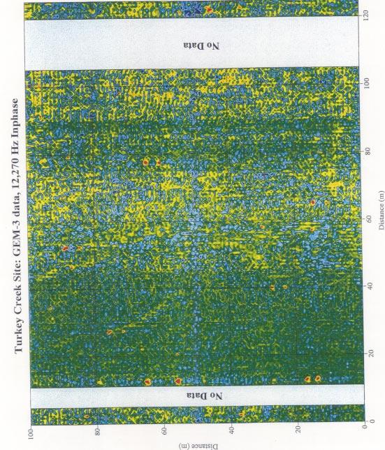
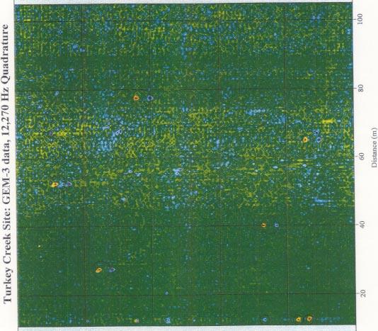
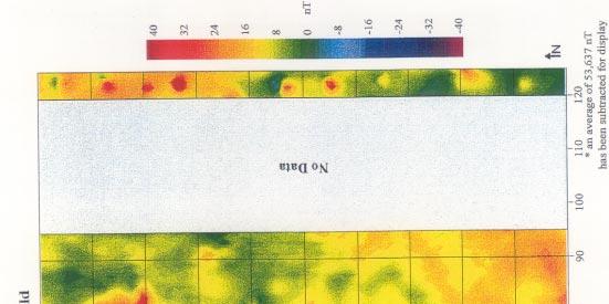
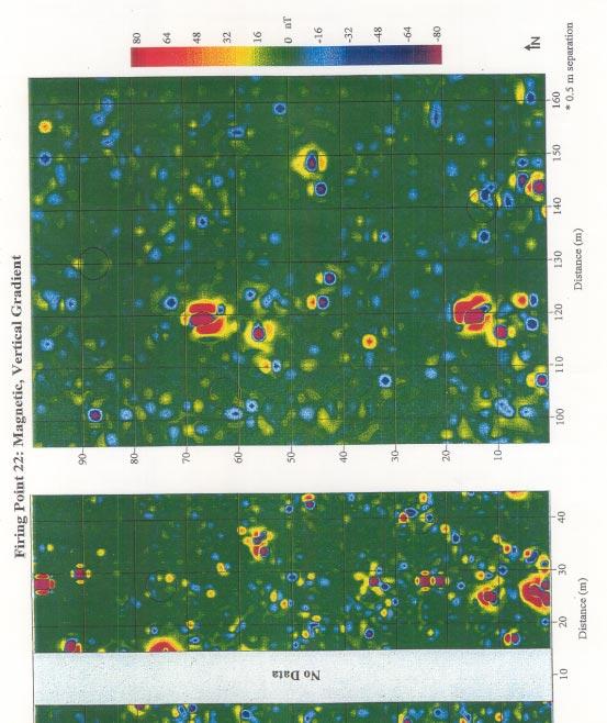
7 Characterization of Two UXO Sites June 1997 the dead reckoning approach. The dead reckoning method involves continuous recording while walking between to known locations (i.e., the starting and end-points of each survey lane). After the survey is complete, the data are linearly interpolated between the known locations. We estimate that the spatial coordinates assigned using the dead-reckoning method are accurate to within one meter. The prototype GEM-3 is currently in a rapidly evolving developmental stage. These data are among the first acquired by this exciting design. We are working to improve the magnetic cavity and, therefore, the overall performance of the GEM-3 instruments. Plots of the electromagnetic (12,270 Hz) and magnetic data are included in Appendices A through D. These data do not incorporate the laser tracking measurements and are plotted using siteconsistent color scales. Circles identify the locations of the center-square registration targets. We believe that each data file has been appropriately converted to BSF guidelines and has a complimentary header file. If problems arise during data analysis. however, please feel free to contact me at telephone number (919) or via at keiswetter@geophex.com. Sincerely, Dean Keiswetter, Ph. D. Deputy Manager, R&D Division cc. Vivian George, Walcoff & Associates N. Quincy Street, Suite 201, Arlington. VA Geophex, Ltd
8 Appendix A Seabee Site, Ft. Carson, Colorado


9

10

11

12
13 Appendix B Turkey Creek Site, Ft. Carson, Colorado
14

15


16 .I


17
18 Appendix C Firing Point 20, Ft. A.P. Hill, Virginia

19

20


21

22
23


24

25

26
27 1
Automated anomaly picking from broadband electromagnetic data in an unexploded ordnance (UXO) survey
 survey") GEOPHYSICS, VOL. 68, NO. 6 (NOVEMBER-DECEMBER 2003); P. 1870 1876, 10 FIGS., 1 TABLE. 10.1190/1.1635039 Automated anomaly picking from broadband electromagnetic data in an unexploded ordnance (UXO) survey
GEOPHYSICS, VOL. 68, NO. 6 (NOVEMBER-DECEMBER 2003); P. 1870 1876, 10 FIGS., 1 TABLE. 10.1190/1.1635039 Automated anomaly picking from broadband electromagnetic data in an unexploded ordnance (UXO) survey
Detection of Pipelines using Sub-Audio Magnetics (SAM)
") Gap Geophysics Australia Pty Ltd. Detection of Pipelines using Sub-Audio Magnetics is a patented technique developed by Gap Geophysics. The technique uses a fast sampling magnetometer to monitor magnetic
Gap Geophysics Australia Pty Ltd. Detection of Pipelines using Sub-Audio Magnetics is a patented technique developed by Gap Geophysics. The technique uses a fast sampling magnetometer to monitor magnetic
Characterization of UXO-Like Targets Using Broadband Electromagnetic Induction Sensors
 652 IEEE TRANSACTIONS ON GEOSCIENCE AND REMOTE SENSING, VOL. 41, NO. 3, MARCH 2003 Characterization of UXO-Like Targets Using Broadband Electromagnetic Induction Sensors Haoping Huang and I. J. Won Abstract
 This article was originally published in a journal published by Elsevier, and the attached copy is provided by Elsevier for the author s benefit and for the benefit of the author s institution, for non-commercial
Environmental Quality and Installations Program. UXO Characterization: Comparing Cued Surveying to Standard Detection and Discrimination Approaches
 ERDC/EL TR-08-34 Environmental Quality and Installations Program UXO Characterization: Comparing Cued Surveying to Standard Detection and Discrimination Approaches Report 3 of 9 Test Stand Magnetic and
Hand-Held Dual Magnetic/Electromagnetic Induction Sensor. David Wright, Hollis H. Bennett, Jr., Linda Peyman Dove, and Dwain K.
 ERDC/EL TR-08-15 Multi-Sensor Systems Development for UXO Detection and Discrimination Hand-Held Dual Magnetic/Electromagnetic Induction Sensor David Wright, Hollis H. Bennett, Jr., Linda Peyman Dove,
THE GOAL of any detection system is to achieve a high
 IEEE TRANSACTIONS ON GEOSCIENCE AND REMOTE SENSING, VOL. 37, NO. 2, MARCH 1999 811 An Improved Bayesian Decision Theoretic Approach for Land Mine Detection Leslie Collins, Member, IEEE, Ping Gao, Student
Automated Identification of Buried Landmines Using Normalized Electromagnetic Induction Spectroscopy
 640 IEEE TRANSACTIONS ON GEOSCIENCE AND REMOTE SENSING, VOL. 41, NO. 3, MARCH 2003 Automated Identification of Buried Landmines Using Normalized Electromagnetic Induction Spectroscopy Haoping Huang and
Active induction balance method for metal detector sensing head utilizing transmitterbucking and dual current source
 University of Zagreb Faculty of Electrical Engineering and Computing Department of Electronic Systems and Information Processing Active induction balance method for metal detector sensing head utilizing
Technical Note TN-30 WHY DOESN'T GEONICS LIMITED BUILD A MULTI-FREQUENCY EM31 OR EM38? J.D. McNeill
 Tel: (905) 670-9580 Fax: (905) 670-9204 GEONICS LIMITED E-mail:geonics@geonics.com 1745 Meyerside Dr. Unit 8 Mississauaga, Ontario Canada L5T 1C6 URL:http://www.geonics.com Technical Note TN-30 WHY DOESN'T
Frequency Domain Electromagnetic Sensor Array Development
 Frequency Domain Electromagnetic Sensor Array Development Final Report SERDP SEED Project MM-1450 September 17, 2007 Principal Investigator: David J. Wright SAIC, Advanced Sensors and Analysis Division
Electrical Resistivity Imaging
 Approved for Public Release; Distribution Unlimited Electrical Resistivity Imaging David Hull US Army Research Lab hull@arl.army.mil 17 Jun 2009 ARL Workshop on Personnel, Vehicle, and Tunnel Detection
GCM mapping Vildbjerg - HydroGeophysics Group - Aarhus University
 GCM mapping Vildbjerg - HydroGeophysics Group - Aarhus University GCM mapping Vildbjerg Report number 06-06-2017, June 2017 Indholdsfortegnelse 1. Project information... 2 2. DUALEM-421s... 3 2.1 Setup
Repeatability study of helicopter-borne electromagnetic data
 GEOPHYSICS, VOL. 71, NO. 6 NOVEMBER-DECEMBER 2006 ; P. G285 G290, 9 FIGS., 2 TABLES. 10.1190/1.2353797 Repeatability study of helicopter-borne electromagnetic data Haoping Huang 1 and Allen Cogbill 2 ABSTRACT
Main Menu. Summary: Introduction:
 UXO Detection and Prioritization Using Combined Airborne Vertical Magnetic Gradient and Time-Domain Electromagnetic Methods Jacob Sheehan, Les Beard, Jeffrey Gamey, William Doll, and Jeannemarie Norton,
Abstract. Introduction
 TARGET PRIORITIZATION IN TEM SURVEYS FOR SUB-SURFACE UXO INVESTIGATIONS USING RESPONSE AMPLITUDE, DECAY CURVE SLOPE, SIGNAL TO NOISE RATIO, AND SPATIAL MATCH FILTERING Darrell B. Hall, Earth Tech, Inc.,
U. S. Army Corps of Engineers
 U. S. Army Corps of Engineers Geophysical Methods in the Ordnance Detection and Discrimination Study at Former Fort Ord, California Fort Ord SMART Team Public Meeting 2 December 1999 Dwain K. Butler, Ph.D.,
Lab 1. Resonance and Wireless Energy Transfer Physics Enhancement Programme Department of Physics, Hong Kong Baptist University
 Lab 1. Resonance and Wireless Energy Transfer Physics Enhancement Programme Department of Physics, Hong Kong Baptist University 1. OBJECTIVES Introduction to the concept of resonance Observing resonance
Case Study: Advanced Classification Contracting at Former Camp San Luis Obispo
 Case Study: Advanced Classification Contracting at Former Camp San Luis Obispo John M. Jackson Geophysicist USACE-Sacramento District US Army Corps of Engineers BUILDING STRONG Agenda! Brief Site Description
Identification of UXO by regularized inversion for Surface Magnetic Charges Nicolas Lhomme, Leonard Pasion and Doug W. Oldenburg
 Identification of UXO by regularized inversion for Surface Magnetic Charges Nicolas Lhomme, Leonard Pasion and Doug W. Oldenburg The University of British Columbia, Vancouver, BC, Canada Sky Research Inc.,
Microtremor Array Measurements and Three-component Microtremor Measurements in San Francisco Bay Area
 Microtremor Array Measurements and Three-component Microtremor Measurements in San Francisco Bay Area K. Hayashi & D. Underwood Geometrics, Inc., United States SUMMARY: Microtremor array measurements and
Electromagnetic Induction
 Electromagnetic Induction Recap the motivation for using geophysics We have problems to solve Slide 1 Finding resources Hydrocarbons Minerals Ground Water Geothermal Energy SEG Distinguished Lecture slide
MARINE GEOPHYSICAL PROVE-OUT AND SURVEY AT FLAG LAKE BOMBING RANGE BARKSDALE AIR FORCE BASE, LOUISIANA
 MARINE GEOPHYSICAL PROVE-OUT AND SURVEY AT FLAG LAKE BOMBING RANGE BARKSDALE AIR FORCE BASE, LOUISIANA Garrick Marcoux 1, Wallace Robertson 2, Boban Stojanovic 1, Jeffrey B. Hackworth 1 1 FPM Geophysical
Gradiometers for UXO Detection. Alan Cameron GSE Rentals
 Gradiometers for UXO Detection Alan Cameron GSE Rentals Traditional Detection Methods. Pulse Induced Metal Detector Towed Magnetometer Pulse Induction Sensors Pro s Will detect any conducting metal Con
Welcome to Munitions Response and Remediation Moderator: Ms. Nelline Kowbel Speakers:
 Welcome to Munitions Response and Remediation Moderator: Ms. Nelline Kowbel Speakers: Mr. John Jackson, USACE, Sacramento District Mr. Charles Welk, InDepth Corporation Mr. Roman Racca, California Department
ELECTROMAGNETIC FIELD APPLICATION TO UNDERGROUND POWER CABLE DETECTION
 ELECTROMAGNETIC FIELD APPLICATION TO UNDERGROUND POWER CABLE DETECTION P Wang *, K Goddard, P Lewin and S Swingler University of Southampton, Southampton, SO7 BJ, UK *Email: pw@ecs.soton.ac.uk Abstract:
Small, Low Power, High Performance Magnetometers
 Small, Low Power, High Performance Magnetometers M. Prouty ( 1 ), R. Johnson ( 1 ) ( 1 ) Geometrics, Inc Summary Recent work by Geometrics, along with partners at the U.S. National Institute of Standards
High-]FrequencyElectric Field Measurement Using a Toroidal Antenna
![High-]FrequencyElectric Field Measurement Using a Toroidal Antenna](/thumbs/87/96632311.jpg "High-]FrequencyElectric Field Measurement Using a Toroidal Antenna") LBNL-39894 UC-2040 ERNEST ORLANDO LAWRENCE B ERKELEY NAT o NAL LABo RATO RY High-]FrequencyElectric Field Measurement Using a Toroidal Antenna Ki Ha Lee Earth Sciences Division January 1997!.*. * c DSCLAMER
LBNL-39894 UC-2040 ERNEST ORLANDO LAWRENCE B ERKELEY NAT o NAL LABo RATO RY High-]FrequencyElectric Field Measurement Using a Toroidal Antenna Ki Ha Lee Earth Sciences Division January 1997!.*. * c DSCLAMER
COMAPARISON OF SURVEY RESULTS FROM EM-61 AND BEEP MAT FOR UXO IN BASALTIC TERRAIN. Abstract
 COMAPARISON OF SURVEY RESULTS FROM EM-61 AND BEEP MAT FOR UXO IN BASALTIC TERRAIN Les P. Beard, Battelle-Oak Ridge, Oak Ridge, TN Jacob Sheehan, Battelle-Oak Ridge William E. Doll, Battelle-Oak Ridge Pierre
Environmental Quality Technology Program
 ERDC/EL TR-09-16 Environmental Quality Technology Program Unexploded Ordnance (UXO) Data Analysis System (DAS) Ricky A. Goodson, John Cliff Morgan, Dwain K. Butler, Morris P. Fields, Hollis H. Bennett,
 Page 1 of 10 SENSOR EVALUATION STUDY FOR USE WITH TOWED ARRAYS FOR UXO SITE CHARACTERIZATION J.R. McDonald Chemistry Division, Code 6110, Naval Research Laboratory Washington, DC 20375, 202-767-3556 Richard
Phase I: Evaluate existing and promising UXO technologies with emphasis on detection and removal of UXO.
 EXECUTIVE SUMMARY This report summarizes the Jefferson Proving Ground (JPG) Technology Demonstrations (TD) Program conducted between 1994 and 1999. These demonstrations examined the current capability
Environmental Laboratory. Evaluation of Multi-Sensor Unexploded Ordnance (UXO) Detection System Developed by Geophysical Solutions ERDC/EL TR-06-6
 Detection System Developed by Geophysical Solutions ERDC/EL TR-06-6") ERDC/EL TR-06-6 Environmental Quality Technology Program Evaluation of Multi-Sensor Unexploded Ordnance (UXO) Detection System Developed by Geophysical Solutions Hollis H. Bennett, Jr., and Morris P. Fields
ERDC/EL TR-06-6 Environmental Quality Technology Program Evaluation of Multi-Sensor Unexploded Ordnance (UXO) Detection System Developed by Geophysical Solutions Hollis H. Bennett, Jr., and Morris P. Fields
PROJECTILE-BORNE INSTRUMENTATION FOR CHARACTERIZATION OF IN-BORE ENVIRONMENTS. Philip J. Peregino II, Ed Bukowski ABSTRACT
 23 RD INTERNATIONAL SYMPOSIUM ON BALLISTICS TARRAGONA, SPAIN 16-20 APRIL 2007 PROJECTILE-BORNE INSTRUMENTATION FOR CHARACTERIZATION OF IN-BORE ENVIRONMENTS U.S. Army Research Laboratory AMRSD-ARL-WM-BA
Govt. Engineering College Jhalawar Model Question Paper Subject- Remote Sensing & GIS
 Govt. Engineering College Jhalawar Model Question Paper Subject- Remote Sensing & GIS Time: Max. Marks: Q1. What is remote Sensing? Explain the basic components of a Remote Sensing system. Q2. What is
APPENDIX I Geophysical Data. Geophysical data is provided in the electronic copy of this report.
 APPENDIX I Geophysical Data Geophysical data is provided in the electronic copy of this report. This page intentionally left blank. 1.0 INTRODUCTION SCHILLING AIR FORCE BASE GEOPHYSICAL SURVEY Parsons
APPENDIX E INSTRUMENT VERIFICATION STRIP REPORT. Final Remedial Investigation Report for the Former Camp Croft Spartanburg, South Carolina Appendices
 Final Remedial Investigation Report for the Former Camp Croft APPENDIX E INSTRUMENT VERIFICATION STRIP REPORT Contract No.: W912DY-10-D-0028 Page E-1 Task Order No.: 0005 Final Remedial Investigation Report
EVALUATING THE EFFECTIVENESS OF VARYING TRANSMITTER WAVEFORMS FOR UXO DETECTION IN MAGNETIC SOIL ENVIRONMENTS. Abstract.
 EVALUATING THE EFFECTIVENESS OF VARYING TRANSMITTER WAVEFORMS FOR UXO DETECTION IN MAGNETIC SOIL ENVIRONMENTS Leonard R. Pasion, U. of British Columbia, Vancouver, BC Sean E. Walker, Sky Research Inc.,
Overview. GEM Systems Inc. 135 Spy Crt. Markham Ontario, L3R 5H6 Ph /4/2016 1
 Overview GEM Systems is celebrating 35 years in business leading the advancement of magnetometer technology. GEM is the number one global leader in the manufacture and sale of high precision magnetometers.
Terminology and Acronyms used in ITRC Geophysical Classification for Munitions Response Training
 Terminology and Acronyms used in ITRC Geophysical Classification for Munitions Response Training ITRC s Geophysical Classification for Munitions Response training and associated document (GCMR 2, 2015,
Disruption Opportunity Special Notice DARPA-SN Imaging Through Almost Anything, Anywhere (ITA3)
") Disruption Opportunity Special Notice DARPA-SN-17-72 Imaging Through Almost Anything, Anywhere (ITA3) I. Opportunity Description The Defense Advanced Research Projects Agency (DARPA) Defense Sciences Office
Disruption Opportunity Special Notice DARPA-SN-17-72 Imaging Through Almost Anything, Anywhere (ITA3) I. Opportunity Description The Defense Advanced Research Projects Agency (DARPA) Defense Sciences Office
Detecting metal objects in magnetic environments using a broadband electromagnetic method
 GEOPHYSICS, VOL. 68, NO. 6 (NOVEMBER-DECEMBER 2003); P. 1877 1887, 13 FIGS., 2 TABLES. 10.1190/1.1635040 Detecting metal objects in magnetic environments using a broadband electromagnetic method Haoping
746A27 Remote Sensing and GIS
 746A27 Remote Sensing and GIS Lecture 1 Concepts of remote sensing and Basic principle of Photogrammetry Chandan Roy Guest Lecturer Department of Computer and Information Science Linköping University What
Magnetic field measurements, Helmholtz pairs, and magnetic induction.
 Magnetic field measurements, Helmholtz pairs, and magnetic induction. Part 1: Measurement of constant magnetic field: 1. Connections and measurement of resistance: a. Pick up the entire magnet assembly
Unexploded ordnance (UXO) contamination is a high-priority problem for the Department of Defense (DoD). As
 contamination is a high-priority problem for the Department of Defense (DoD). As") H.H. Nelson 1 and J.R. McDonald 2 1 Chemistry Division 2 AETC, Inc. Airborne Magnetometry Surveys for Detection of Unexploded Ordnance Unexploded ordnance (UXO) contamination is a high-priority problem
H.H. Nelson 1 and J.R. McDonald 2 1 Chemistry Division 2 AETC, Inc. Airborne Magnetometry Surveys for Detection of Unexploded Ordnance Unexploded ordnance (UXO) contamination is a high-priority problem
STANDARD OPERATING PROCEDURES SOP:: 2057 PAGE: 1 of 6 REV: 0.0 DATE: 07/11/03
 PAGE: 1 of 6 1.0 SCOPE AND APPLICATION 2.0 METHOD SUMMARY CONTENTS 3.0 SAMPLE PRESERVATION, CONTAINERS, HANDLING, AND STORAGE 4.0 INTERFERENCES AND POTENTIAL PROBLEMS 5.0 EQUIPMENT/APPARATUS 6.0 REAGENTS
Overview. GEM Systems Inc. 135 Spy Crt. Markham Ontario, L3R 5H6 Ph /20/2017 1
 Overview Since 1980, GEM Systems has been the business leader in the advancement of magnetometer technology. GEM is the number one global leader in the manufacture and sale of high precision magnetometers.
LCLS-II TN Vibration measurements across the SLAC site
 LCLS-II TN Vibration measurements across the SLAC site LCLS-II TN-15-35 9/25/2015 Georg Gassner September 25, 2015 LCLSII-TN-XXXX L C L S - I I T E C H N I C A L N O T E 1 Introduction This document collects
Record Adoption of ASTM E b as an Update of SE Nov-12 Page 1 of 5
 17-Nov-12 Page 1 of 5 From Article 2, Mandatory Appendix V V-220 GENERAL REQUIREMENTS (a) The Standard Terminology for Nondestructive Examinations (ASTM E1316) has been adopted by the Committee as SE-
Range Sensing strategies
 Range Sensing strategies Active range sensors Ultrasound Laser range sensor Slides adopted from Siegwart and Nourbakhsh 4.1.6 Range Sensors (time of flight) (1) Large range distance measurement -> called
GENERATION OF SIGNALS USING LABVIEW FOR MAGNETIC COILS WITH POWER AMPLIFIERS
 GENERATION OF SIGNALS USING LABVIEW FOR MAGNETIC COILS WITH POWER AMPLIFIERS Ashmi G V 1, Meena M S 2 1 ER&DCI-IT, Centre for Development of Advanced Computing, Thiruvananthapuram(India) 2 LAMP Group,
INTRAWEAPON WIRELESS COMMUNICATION
 INTRAWEAPON WIRELESS COMMUNICATION Robert A. Sinclair, Dr. Carl Smith, Robert W. Schneider NVE Corporation, Eden Prairie, MN Technology in Fuzing 48th Annual Fuze Conference Charlotte, North Carolina April
DEVELOPMENT OF A NEW OPTICALLY PUMPED POTASIUM MAGNETOMETER
 DEVELOPMENT OF A NEW OPTICALLY PUMPED POTASIUM MAGNETOMETER Dr. Ivan Hrvoic, Ph.D., P.Eng. President, GEM Advanced Magnetometers Greg M. Hollyer, M.Sc.(Eng.), P.Eng. Manager, Communication Mike Wilson
Lecture 2. Electromagnetic radiation principles. Units, image resolutions.
 NRMT 2270, Photogrammetry/Remote Sensing Lecture 2 Electromagnetic radiation principles. Units, image resolutions. Tomislav Sapic GIS Technologist Faculty of Natural Resources Management Lakehead University
Department of Communications, Marine and Natural Resources
 THE NORANDA/ BILLITON AIRBORNE TEM AND MAGNETIC SURVEY (1997) OVER THE TULLAMORE AREA June 2002 Department of Communications, Marine and Natural Resources Department of Communications, Marine and Natural
MRI SYSTEM COMPONENTS Module One
 MRI SYSTEM COMPONENTS Module One 1 MAIN COMPONENTS Magnet Gradient Coils RF Coils Host Computer / Electronic Support System Operator Console and Display Systems 2 3 4 5 Magnet Components 6 The magnet The
Transformers 1 of 25 Boardworks Ltd 2016
 Transformers 1 of 25 Boardworks Ltd 2016 Transformers 2 of 25 Boardworks Ltd 2016 Linking circuits with magnetism 3 of 25 Boardworks Ltd 2016 Transformers 4 of 25 Boardworks Ltd 2016 Power can be transferred
Sferic signals for lightning sourced electromagnetic surveys
 Sferic signals for lightning sourced electromagnetic surveys Lachlan Hennessy* RMIT University hennessylachlan@gmail.com James Macnae RMIT University *presenting author SUMMARY Lightning strikes generate
AIRBORNE GEOPHYSICS FOR SHALLOW OBJECT DETECTION: TECHNOLOGY UPDATE , (865) ,
 ,") AIRBORNE GEOPHYSICS FOR SHALLOW OBJECT DETECTION: TECHNOLOGY UPDATE 2003 W. E. Doll 1, T. J. Gamey 1, L. P. Beard 1, D. T. Bell 1 and J. S. Holladay 2 1 Environmental Sciences Division, Oak Ridge National
AIRBORNE GEOPHYSICS FOR SHALLOW OBJECT DETECTION: TECHNOLOGY UPDATE 2003 W. E. Doll 1, T. J. Gamey 1, L. P. Beard 1, D. T. Bell 1 and J. S. Holladay 2 1 Environmental Sciences Division, Oak Ridge National
esa Space Station Electromagnetic Emission and Susceptibility Requirements International Space Station Revision C May 31, 1996 SSP Revision C
 Space Station Electromagnetic Emission and Susceptibility Requirements International Space Station Revision C May 31, 1996 esa european space agency National Aeronautics and Space Administration Space
Geophysical Survey Rock Hill Bleachery TBA Site Rock Hill, South Carolina EP-W EPA, START 3, Region 4 TABLE OF CONTENTS Section Page Signature
 Geophysical Survey Rock Hill Bleachery TBA Site Rock Hill, South Carolina EP-W-05-054 EPA, START 3, Region 4 Prepared for: Tetra Tech EM, Inc. October 12, 2012 Geophysical Survey Rock Hill Bleachery TBA
Background. Computer Vision & Digital Image Processing. Improved Bartlane transmitted image. Example Bartlane transmitted image
 Background Computer Vision & Digital Image Processing Introduction to Digital Image Processing Interest comes from two primary backgrounds Improvement of pictorial information for human perception How
Co-Located Triangulation for Damage Position
 Co-Located Triangulation for Damage Position Identification from a Single SHM Node Seth S. Kessler, Ph.D. President, Metis Design Corporation Ajay Raghavan, Ph.D. Lead Algorithm Engineer, Metis Design
The use of high frequency transducers, MHz, allowing the resolution to target a few cm thick in the first half meter suspect.
 METHODOLOGY GPR (GROUND PROBING RADAR). In recent years the methodology GPR (Ground Probing Radar) has been applied with increasing success under the NDT thanks to the high speed and resolving power. As
GEOPHYSICAL PROVE OUT PLAN
 GEOPHYSICAL PROVE OUT PLAN Conventional Ordnance and Explosive (OE), Removal Action, Five Points Outlying Field, Arlington, Texas Contract No. DACA87-00-D-0035 Task Order 0018 Project No. K06TX002801 Prepared
Mhow (MP) PIN c/o 56 APO RFI : PROCUREMENT OF FAST TRANSIENT RESPONSE ELECTROMAGNETIC PULSE (EMP) SIMULATOR
 PIN c/o 56 APO RFI : PROCUREMENT OF FAST TRANSIENT RESPONSE ELECTROMAGNETIC PULSE (EMP) SIMULATOR") Tele : 07324-256130 Army Centre for Electromagnetics Mhow (MP) PIN - 900444 c/o 56 APO 2710/M/EMP Sml/ 23 Jul 20 To RFI : PROCUREMENT OF FAST TRANSIENT RESPONSE ELECTROMAGNETIC PULSE (EMP) SIMULATOR 1.
Tele : 07324-256130 Army Centre for Electromagnetics Mhow (MP) PIN - 900444 c/o 56 APO 2710/M/EMP Sml/ 23 Jul 20 To RFI : PROCUREMENT OF FAST TRANSIENT RESPONSE ELECTROMAGNETIC PULSE (EMP) SIMULATOR 1.
GCM mapping Gedved - HydroGeophysics Group - Aarhus University
 GCM mapping Gedved - HydroGeophysics Group - Aarhus University GCM mapping Gedved Report number 23-06-2017, June 2017 1. INDHOLDSFORTEGNELSE 1. Indholdsfortegnelse... 1 2. Project information... 2 3. DUALEM-421s...
Improving electromagnetic induction detector technology in humanitarian demining
 57 APPENDIX 4 Improving electromagnetic induction detector technology in humanitarian demining R.C. Bailey, University of Toronto, Departments of Geology and Physics, Toronto, Canada G.F. West, University
The History and Future of Measurement Technology in Sumitomo Electric
 ANALYSIS TECHNOLOGY The History and Future of Measurement Technology in Sumitomo Electric Noritsugu HAMADA This paper looks back on the history of the development of measurement technology that has contributed
Module 3 Introduction to GIS. Lecture 8 GIS data acquisition
 Module 3 Introduction to GIS Lecture 8 GIS data acquisition GIS workflow Data acquisition (geospatial data input) GPS Remote sensing (satellites, UAV s) LiDAR Digitized maps Attribute Data Management Data
March 18, SOFTHARD Technology Ltd. Lesna 52, Marianka
 March 18, 2009 SOFTHARD Technology Ltd Lesna 52, 900 33 Marianka 1 Table of Contents 1 Table of Contents... 2 2 Revision History... 3 3 Disclaimers... 4 4 Privacy Information... 4 5 Document Scope and
Shock Sensor Module This module is digital shock sensor. It will output a high level signal when it detects a shock event.
 Item Picture Description KY001: Temperature This module measures the temperature and reports it through the 1-wire bus digitally to the Arduino. DS18B20 (https://s3.amazonaws.com/linksprite/arduino_kits/advanced_sensors_kit/ds18b20.pdf)
Environmental Quality and Installations Program. UXO Characterization: Comparing Cued Surveying to Standard Detection and Discrimination Approaches
 ERDC/EL TR-08-35 Environmental Quality and Installations Program UXO Characterization: Comparing Cued Surveying to Standard Detection and Discrimination Approaches Report 4 of 9 UXO Characterization Using
Chapter 9: Light, Colour and Radiant Energy. Passed a beam of white light through a prism.
 Chapter 9: Light, Colour and Radiant Energy Where is the colour in sunlight? In the 17 th century (1600 s), Sir Isaac Newton conducted a famous experiment. Passed a beam of white light through a prism.
Lab 2 Radio-frequency Coils and Construction
 ab 2 Radio-frequency Coils and Construction Background: In order for an MR transmitter/receiver coil to work efficiently to excite and detect the precession of magnetization, the coil must be tuned to
SYSTEM 5900 SIDE SCAN SONAR
 SYSTEM 5900 SIDE SCAN SONAR HIGH-RESOLUTION, DYNAMICALLY FOCUSED, MULTI-BEAM SIDE SCAN SONAR Klein Marine System s 5900 sonar is the flagship in our exclusive family of multi-beam technology-based side
MSB Imagery Program FAQ v1
 MSB Imagery Program FAQ v1 (F)requently (A)sked (Q)uestions 9/22/2016 This document is intended to answer commonly asked questions related to the MSB Recurring Aerial Imagery Program. Table of Contents
Old & New? INTRODUCTION. The Best Proximal Geophysical Detector Ever!
 Measuring Soil Conductivity with Geonics Limited Electromagnetic Geophysical Instrumentation INTRODUCTION This presentation will briefly discuss the principles of operation and the practical applications
AGRON / E E / MTEOR 518: Microwave Remote Sensing
 AGRON / E E / MTEOR 518: Microwave Remote Sensing Dr. Brian K. Hornbuckle, Associate Professor Departments of Agronomy, ECpE, and GeAT bkh@iastate.edu What is remote sensing? Remote sensing: the acquisition
A Method of Mapping Resistive or Conductive offshore Targets also an Apparatus for Applying the Method
 A Method of Mapping Resistive or Conductive offshore Targets also an Apparatus for Applying the Method BACKGROUND OF THE INVENTION 1. Field of the Invention The present invention is related to a method
Contents. 2.3 The color code scheme is defined in the following table:
 Contents 1. Introduction 2. Simulation conditions 2.1 Test Structure 2.2 Magnetic Measurement 2.3 The color code scheme is defined in the following table: 2.4 AH1802 Magnetic Characteristics 2.5 Permanent
Locating good conductors by using the B-field integrated from partial db/dt waveforms of timedomain
 Locating good conductors by using the integrated from partial waveforms of timedomain EM systems Haoping Huang, Geo-EM, LLC Summary An approach for computing the from time-domain data measured by an induction
An acousto-electromagnetic sensor for locating land mines
 An acousto-electromagnetic sensor for locating land mines Waymond R. Scott, Jr. a, Chistoph Schroeder a and James S. Martin b a School of Electrical and Computer Engineering b School of Mechanical Engineering
Chapter 2 Definitions and Acronyms
 Advanced Materials and Technology Manual TABLE OF CONTENTS.0 Introduction... 1.1 Definitions... FIGURE.1 Schematic of Gridded All Passes Data and Gridded Final Coverage Data.... 4 FIGURE. Schematic of
HELICOPTER-BORNE GEOPHYSICAL SURVEY SYSTEMS
 HELICOPTER-BORNE GEOPHYSICAL SURVEY SYSTEMS APPLICATIONS: base & precious metals exploration diamondiferous kimberlite exploration geological mapping mapping of fault zones for engineering and mining applications
INSTRUCTION MANUAL SERIES TRANSMITTER
 INSTRUCTION MANUAL 284-512 SERIES TRANSMITTER TABLE OF CONTENTS General Description........................... Pg 1 Specifications............................... Pg 2 Installation..................................
4.4 The transient electromagnetic method (TEM)
") 4.4 The transient electromagnetic method (TEM) 4.4 The transient electromagnetic method (TEM) 4.4.1 Basic principles and measuring techniques in TEM By the transient electromagnetic method, TEM, the electrical
4.4 The transient electromagnetic method (TEM) 4.4 The transient electromagnetic method (TEM) 4.4.1 Basic principles and measuring techniques in TEM By the transient electromagnetic method, TEM, the electrical
I p = V s = N s I s V p N p
 UNIT G485 Module 1 5.1.3 Electromagnetism 11 For an IDEAL transformer : electrical power input = electrical power output to the primary coil from the secondary coil Primary current x primary voltage =
Accurate Utility Depth Measurements Using the Spar 300
 Accurate Utility Depth Measurements Using the Spar 3 This Application Note addresses how to obtain accurate subsurface utility depths using the model-based methods employed by the Spar 3. All electromagnetic
THE BHP AIRBORNE TEM AND MAGNETIC SURVEY (1996) over the GALMOY AREA
 over the GALMOY AREA") THE BHP AIRBORNE TEM AND MAGNETIC SURVEY (1996) over the GALMOY AREA Department of the Marine and Natural Resources THE BHP AIRBORNE TEM AND MAGNETIC SURVEY (1996) over the GALMOY AREA Compiled by Orla
THE BHP AIRBORNE TEM AND MAGNETIC SURVEY (1996) over the GALMOY AREA Department of the Marine and Natural Resources THE BHP AIRBORNE TEM AND MAGNETIC SURVEY (1996) over the GALMOY AREA Compiled by Orla
Non-destructive testing Equipment for eddy current examination Array probe characteristics and verification
 Provläsningsexemplar / Preview INTERNATIONAL STANDARD ISO 20339 First edition 2017-03 Non-destructive testing Equipment for eddy current examination Array probe characteristics and verification Essais
Inductive Conductivity Measurement of Seawater
 Inductive Conductivity Measurement of Seawater Roger W. Pryor, Ph.D. Pryor Knowledge Systems *Corresponding author: 498 Malibu Drive, Bloomfield Hills, MI, 48302-223, rwpryor@pksez.com Abstract: Approximately
A Hybrid Indoor Tracking System for First Responders
 A Hybrid Indoor Tracking System for First Responders Precision Indoor Personnel Location and Tracking for Emergency Responders Technology Workshop August 4, 2009 Marc Harlacher Director, Location Solutions
EN 62479:2010 ASSESSMENT REPORT WIN CHANNEL ELECTRONICS (HK) CO., LTD
 CO., LTD") EN 62479:2010 ASSESSMENT REPORT For WIN CHANNEL ELECTRONICS (HK) CO., LTD No.1, Shangxing Road, Shangjiao, Changan Town, Dongguan, Guangdong, China Tested Model: 318EU Multiple Models: 73500, 73506, FREECOMM
EN 62479:2010 ASSESSMENT REPORT For WIN CHANNEL ELECTRONICS (HK) CO., LTD No.1, Shangxing Road, Shangjiao, Changan Town, Dongguan, Guangdong, China Tested Model: 318EU Multiple Models: 73500, 73506, FREECOMM
HANDBOOK OF NONDESTRUCTIVE EVALUATION (NDE) CAP ABILITY AND RELIABILITY*
 CAP ABILITY AND RELIABILITY*") HANDBOOK OF NONDESTRUCTIVE EVALUATION (NDE) CAP ABILITY AND RELIABILITY* INTRODUCTION Ward D. Rummel Martin Marietta Astronautics Group Post Office Box 179, Mail Stop T320 Denver, CO 80201 George A. Matzkanin
HANDBOOK OF NONDESTRUCTIVE EVALUATION (NDE) CAP ABILITY AND RELIABILITY* INTRODUCTION Ward D. Rummel Martin Marietta Astronautics Group Post Office Box 179, Mail Stop T320 Denver, CO 80201 George A. Matzkanin
Improvement of signal to noise ratio by Group Array Stack of single sensor data
 P-113 Improvement of signal to noise ratio by Artatran Ojha *, K. Ramakrishna, G. Sarvesam Geophysical Services, ONGC, Chennai Summary Shot generated noise and the cultural noise is a major problem in
TRANSFORMER OPERATION
 Chapter 3 TRANSFORMER OPERATION 1 A transformer is a static device (no moving parts) used to transfer energy from one AC circuit to another. This transfer of energy may involve an increase or decrease
The Signature VM package delivers vessel-mounted AD2CP capabilities based on present-day technology
 The package delivers vessel-mounted AD2CP capabilities based on present-day technology Until now, ADCP current surveys have been complex and time-consuming processes. A successful current survey depends
DARPA-SN Imaging Through Almost Anything, Anywhere (ITA3) Frequently Asked Questions (FAQs) as of 9/11/2017
 Frequently Asked Questions (FAQs) as of 9/11/2017") DARPA-SN-17-72 Imaging Through Almost Anything, Anywhere (ITA3) Frequently Asked Questions (FAQs) as of 9/11/2017 35Q: This FAQ supercedes 30Q. Are there any plans to postpone the solicitation deadline
DARPA-SN-17-72 Imaging Through Almost Anything, Anywhere (ITA3) Frequently Asked Questions (FAQs) as of 9/11/2017 35Q: This FAQ supercedes 30Q. Are there any plans to postpone the solicitation deadline
DEEP FLAW DETECTION WITH GIANT MAGNETORESISTIVE (GMR) BASED SELF-NULLING PROBE
 BASED SELF-NULLING PROBE") DEEP FLAW DETECTION WITH GIANT MAGNETORESISTIVE (GMR) BASED SELF-NULLING PROBE Buzz Wincheski and Min Namkung NASA Langley Research Center Hampton, VA 23681 INTRODUCTION The use of giant magnetoresistive
DEEP FLAW DETECTION WITH GIANT MAGNETORESISTIVE (GMR) BASED SELF-NULLING PROBE Buzz Wincheski and Min Namkung NASA Langley Research Center Hampton, VA 23681 INTRODUCTION The use of giant magnetoresistive