Appendix C7. Geotechnical Assessment Report
|
|
|
- Cassandra Sharp
- 5 years ago
- Views:
Transcription

1 Appendix C7 Geotechnical Assessment Report
 76 7 Web: www.gcs-sa.")
 Ltd. Reg No: /76/7 Est.")
2 a Old Main Road, Judges Walk, Kloof, Kwazulu-Natal, South Africa, 6 PO Box 89, Gillitts, 6, South Africa Tel: +7 () 76 7 Fax: +7 () 76 7 Web: Geotechnical Investigation for the Maquasa East new Coal Discard Dump Report Version June Kangra GCS Project Number: -7 Client Reference: Kangra GCS (Pty) Ltd. Reg No: /76/7 Est. 987 Offices: Durban Johannesburg Lusaka Ostrava Pretoria Windhoek Directors: AC Johnstone (Managing) PF Labuschagne AWC Marais S Pilane F Pieterse
3 Kangra Kangra Maquasa East Discard Dump Report Version June Kangra -7 DOCUMENT ISSUE STATUS Report Issue Draft GCS Reference Number GCS Ref - -7 Client Reference Kangra Title Geotechnical Investigation for the Kangra Maquasa East Discard Dump Name Signature Date Author Document Reviewer Director Stephen Kelly Andrew Johnstone Andrew Johnstone LEGAL NOTICE This report or any proportion thereof and any associated documentation remain the property of GCS until the mandator effects payment of all fees and disbursements due to GCS in terms of the GCS Conditions of Contract and Project Acceptance Form. Notwithstanding the aforesaid, any reproduction, duplication, copying, adaptation, editing, change, disclosure, publication, distribution, incorporation, modification, lending, transfer, sending, delivering, serving or broadcasting must be authorised in writing by GCS. -7 June Page ii
4 Kangra Kangra Maquasa East Discard Dump EXECUTIVE SUMMARY GCS (Pty) Ltd. was contracted by Kangra to undertake a Geotechnical Investigation for the Maquasa East Coal Discard Dump. The report is outlined below and includes the geology of the site and gives recommendations pertaining to the proposed development. The site is characterised by residual sandstone and shale with a pedogenic horizon in different stages of cementation. The bulk of the material is clayey sand with occurrences of silt and gravel. -7 June Page iii
5 Kangra Kangra Maquasa East Discard Dump CONTENTS PAGE INTRODUCTION... SCOPE OF WORK... SITE DESCRIPTION... FIELD WORK... GEOLOGY SITE GEOLOGY: COLLUVIUM: RESIDUAL SANDSTONE: RESIDUAL SHALE SHALE BEDROCK PEDOGENIC FERROCRETE... 7 GROUNDWATER LABORATORY TESTING LABORATORY TESTING SUMMARY MATERIALS CLASSIFICATION:... 7 DEVELOPMENT GUIDELINES PROPOSED DEVELOPMENT: EXCAVATION REQUIREMENTS AND TRENCHABILITY: MATERIALS EVALUATION AND SUBGRADE TREATMENT: STABILITY OF THE SITE DRAINAGE PIPE BEDDING DWAF MINIMUM REQUIREMENTS FOR LANDFILL CONSTRUCTION... 8 CONCLUSIONS AND RECOMMENDATIONS... 9 LIST OF FIGURES Figure. IP Figure. IP 9 Figure. IP Figure. IP 6 LIST OF TABLES Table. Site geology summary Table. Groundwater Inspection Summary Table. Average Rainfall Table. Summary of Laboratory Test Results Table. Material Classification and Usage Table 6. Summary of requirements set out by DWA and suitability of natural materials -7 June Page
6 Kangra Kangra Maquasa East Discard Dump LIST OF APPENDICES APPENDIX A... APPENDIX B... FIGURES June Page
7 Kangra Kangra Maquasa East Discard Dump INTRODUCTION GCS Water and Environment (Pty) Ltd. were appointed by Kangra Coal to conduct a Geotechnical Investigation for a new Discard Dump. The field work took place between the dates of - th May. The objective of the report is to provide an indication of the availability of any suitable natural materials for clay liner construction in landfills and the general stability of the site. Other investigations undertaken in close vicinity to the site include: Moore Spence Jones report 9-78, titled, Report to Groundwater Consulting Services (GCS) and Union Fenosa on a Geotechnical Investigation for the Proposed Kangra Coal-Fired Power Station to be Located at Driefontein near Piet Retief, Mpumalanga Province GCS report 9-6, titled, Magnetic and Electromagnetic Geophysical Investigation for Kangra Power Station. The report contains results of the geotechnical investigation with recommendations pertaining to drainage, site stability and materials classification and usage. SCOPE OF WORK The following outlines the scope of the work for the geotechnical investigation: Excavation and assessment of 7 inspection pits according to the Geoterminology Workshop (), Guidelines for Soil and Rock Logging SAIEG-AEG-SAICE; Submission of disturbed and undisturbed soil samples under chain of custody for laboratory testing at Matrolab and Drennan Maud and Partners, in Unmgeni Park and Berea respectively. SITE DESCRIPTION The location of the site is approximately km west of Piet Retief and. km west of Driefontein which can be seen on the Locailty Map provided. The site is topographically flat with a slight slope in a westerly direction at.9%. The site is currently bare with only a small stockpile found midway up the eastern boundary processed at the time of the field investigation. Subsistence grazing of cattle by locals also was observed. The vegetation consists of short to medium length grasses with a concentration of large gum trees towards the central eastern portion. There are no services found on the site, however a conveyer belt bounds the southern portion and construction roads bound the eastern portion. A nonperennial river also runs in a SW-NE direction bounding the western portion of the site. A good visual indication of the site can be seen below in Figures through. -7 June Page

8 Kangra Kangra Maquasa East Discard Dump Figure. IP Figure. IP 9 Figure. IP Figure. IP 6-7 June Page
9 Kangra Kangra Maquasa East Discard Dump FIELD WORK Field work comprised the excavation and assessment of 7 inspection pits, designated IP through IP 7. The inspection pits were excavated using a 7 Ton excavator to depths of between. to greater than. meters. The pits were profiled by an engineering geologist with representative disturbed and undisturbed samples taken to commercial laboratories for testing. IP 6 was emitted from the investigation due to its position in the close vicinity of the working stockpile. The positions of the inspection pits can be seen on the Test Pit Map provided. The logs of the inspection pits can be seen in Appendix A. Geoterminology Workshop (), Guidelines for Soil and Rock Logging in South Africa SAIEG, AEG, SAICE -7 June Page
10 Kangra Kangra Maquasa East Discard Dump GEOLOGY The : Geological Series Map indicates that the site is underlain by Sandstone and Shale of the Vryheid Formation and disseminated Dolerite intrusions of the Karoo Super Group.. Site Geology: The site is predominately characterized by a colluvial horizon underlain by either residual sandstone or shale, which is underlain by either sandstone or shale bedrock. A fairly common pedogenic ferrocrete horizon in different stages of cementation was found, with the excavator refusing on an impenetrable very dense to hardpan ferrocrete horizon in some inspection pits.. Colluvium: The colluvium found on site is characterized by either a dry to slightly moist light grey medium dense intact silty fine sand, or in some of the southern lower lying areas a moist dark grey soft intact slightly silty clay. The horizon ranges in depth from surface to an average.m.. Residual Sandstone: The residual sandstone varied in its characteristics according to depth in the soil profile and presence of water, and could be roughly broken into three different horizons, from..m;..m and. to.m. Residual sandstone was found in IP - IP 8; IP IP ; IP7 IP and IP IP9. From approximately. to between..m a dry to slightly moist yellowish brown to light grey loose to medium dense intact, clayey fine to medium sand. From roughly. to between. -.m a slightly moist to wet reddish brown occasionally mottled yellowish brown medium dense to dense intact with intermittent relic rock structures such as bedding, gravelly clayey sand to clayey sand. Within the sand fraction, majority of the material is fine grained. From. to greater than.m a slightly moist to moist light yellow and light grey dense to very dense and stiff to very stiff intact clayey silty fine sand to sandy silt.. Residual Shale Residual shale was found at IP, IP, IP6, IP and IP to IP7. It is generally dry to moist with various colours ranging from dark grey to yellowish brown soft to very stiff intact with laminations and bedding planes fine sandy gravelly clay to clay. -7 June Page 6
11 Kangra Kangra Maquasa East Discard Dump. Shale Bedrock Shale bedrock was only encountered in IP, IP and IP. It consists of a dark grey highly weathered laminated very fine grained very soft to soft rock, from the Vryheid Formation..6 Pedogenic Ferrocrete Pedogenic ferrocrete was found in IP8, IP9, IP, IP6 to IP8, IP, IP, IP, IP and IP7. The horizon consists of a slightly moist to moist reddish brown to yellowish grey dense becoming very dense intact with varying degrees of cementation, sandy clayey silty fine to medium gravel. Ferrocrete nodules are sub-rounded to rounded fine to medium grained gravel and occasionally occur as an angular cobbled sized mass due to cementation, when breaking up the hardpan. Cementation of the hardpan ferrocrete in some instances was so hard that the excavator refused. A summary of the site geology is observed below in Table. Table. Site Geology Summary Depth (m) Lithology Material description.-. Colluvium.-. Res. Sandstone.-. Res. Sandstone.-. Res. Sandstone Light grey to dark grey; medium dense and soft; silty fine sand and silty clay Yellowish brown to light grey; loose to medium dense; clayey fine to medium sand Reddish brown mottled yellowish brown; medium dense to dense; gravelly clayey sand to clayey sand Light yellow and grey; dense to very dense and stiff to very stiff; clayey silty fine sand to sandy silt Depth (m) Lithology Material Description.-. Res. Shale Yellowish brown; soft to very stiff; sandy gravelly clay to sandy clay.7-. Shale bedrock Dark grey; highly weathered; very soft to soft rock Depth (m) Lithology Material Description.6-. Ferrocrete Reddish brown; dense to very dense occasionally hardpan; sandy clayey silty fine to medium gravel -7 June Page 7
12 Kangra Kangra Maquasa East Discard Dump GROUNDWATER Groundwater seepage was observed in of the inspection pits excavated on site (summarised in Table. below). A ferrocrete horizon was observed in some of the inspection pits investigated. These findings are confirmed by the Moore Spence Jones report 9-78 where permanent water levels were measured in two boreholes at. and 7.m below ground level. Table. Groundwater Inspection Summary IP No. Groundwater seepage depth (m)* Comments. Slow flow rate. Slow to moderate flow rate. Slow flow rate * Below natural ground level Table. Average Rainfall Month Jan Feb Mar Apr May Jun Jul Aug Sep Oct Nov Dec Avg. mm June Page 8
13 Kangra Kangra Maquasa East Discard Dump 6 LABORATORY TESTING 6. Laboratory Testing Summary In order to classify the materials underlying the site and to assess their suitability for use, laboratory testing was performed on selected samples obtained from selected layers in the exposure profiles. The following tests were conducted: Foundation Indicator tests (Particle size analysis including Hydrometer and Atterberg Limit Determination) Materials strength tests comprising Mod AASHTO moisture-density relationship and California Bearing Ration (CBR) tests. Shear strength analysis Permeability testing (Falling head test done at 9% Mod AASHTO) The results of the laboratory tests are given in Appendix B and summarised in Table below. -7 June Page 9
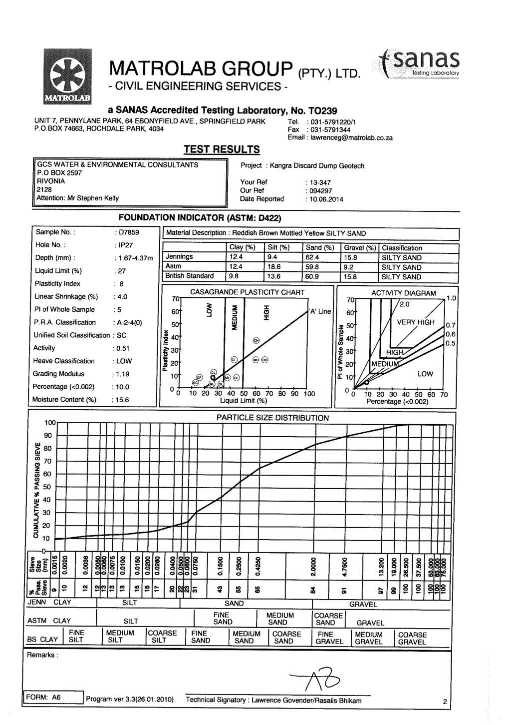
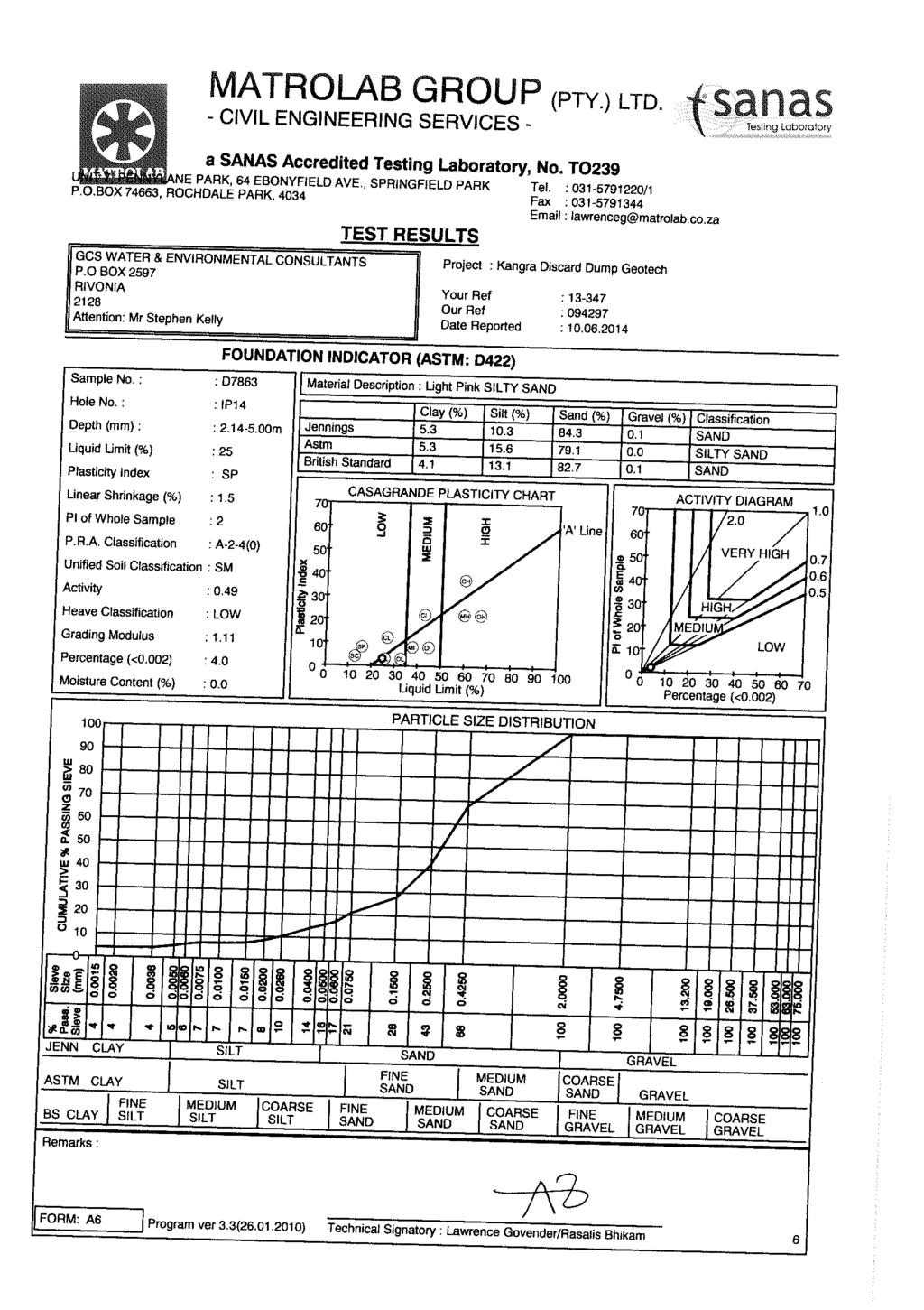
14 Kangra Kangra Maquasa East Discard Dump IP No. Depth (m) Description Reddish brown silty SAND, Res. Sandstone Reddish brown GRAVEL, Ferrocrete Reddish brown clayey gravelly SAND, Res. Sandstone Yellowish brown clayey SAND, Res. Sandstone Yellowish brown clayey SAND, Res. Sandstone Light pink silty SAND, Res. Sandstone Light greyish yellow sandy SILT, Res. Sandstone Light grey silty gravelly SAND, Colluvium Reddish brown clayey SAND, Res. Sandstone Reddish brown clayey gravelly SAND, Res. Sandstone Table. Summary of Laboratory Test results Atterberg Limits Particle Size % Modified AASHTO GM Clay Silt Sand Gravel LL PI LS% MDD (kg/m ) CBR Values (%) Compaction MDD (%) Swell (%) Classification and Activity OMC % A-(); SM; LOW A--(); GW-GC; G6; LOW A--6(); SC; G7; LOW A-(); SC; LOW A-6(); SC; Inferred G8/G9; LOW-MED A--(); SM; Inferred G; SP LOW A-7-(); OL; MED A--(); SM-SC; LOW A-6(6); OL; LOW A--(); SC; LOW -7 June Page
15 Kangra Kangra Maquasa East Discard Dump LL - Liquid Limit GM - Grading Modulus Classification in Terms of: PI - Plasticity Index MDD - Maximum Dry Density USPRA LS - Linear Shrinkage OMC - Optimum Moisture Content Unified Soil Classification System TRH (98) van de Merwe TRH -7 June Page
16 Kangra Kangra Maquasa East Discard Dump 6. Materials Classification: From the results of the laboratory tests provided in Table. above, materials encountered beneath the site have been assessed to provide an indication of their suitability for use in the construction of fills and road pavement layers, and summarized in Table below. Residual Sandstone Table. Materials Classification and Usage Material Type Classification Recommended use Clay =. to.8% Silt = 9. to.% Sand =.6 to 8.% Gravel =. to 6.7% PI = SP to GM =. to.9 Ferrocrete CBR =. 9% MDD CBR =.6 9% MDD CBR =.6 9% MDD CBD = 7. to 98% MDD CBR = 8.7 % MDD A--() to A-7-(); Anticipate <G to G7 Clay =.8% Silt =.% Sand = 7.7% Gravel = 76.% PI = 8 GM =.9 CBR = 9% MDD CBR = 9% MDD CBR 9% MDD CBD = 98% MDD CBR = % MDD Poor to good subgrade material. Generally suitable for use in subgrade layers in construction of bulk fills and selected layers in roads and paved areas, depending on the fines content. According to TRH for use in unpaved roads, material tends to be slippery and occasionally good depending on the sand content. Good subgrade material. Generally suitable for use in subgrade layers in the construction of bulk fills, selected and sub-base layers in road and paved areas. According to TRH for use in unpaved roads, material tends to ravel and corrugate. Colluvium A--(), Anticipate <G6 Clay = % Silt = 8.7% Sand = 6.% Gravel = % PI = GM =. Good subgrade material. Due to volume constraints, material should be stockpiled for final greening. A--(); Anticipate <G -7 June Page
17 Kangra Kangra Maquasa East Discard Dump 7 DEVELOPMENT GUIDELINES 7. Proposed development: The proposed development is a discard dump for coal tailings at the Kangra Maquasa East Site. The discard dump will include two HDPE lined Pollution Control Dams to the north, and a phase dump plan progressing in north to south direction. Toe-drains will be located along the length the western downslope side, with a storm water trench located towards the south of the site discharging into the surface water system. 7. Excavation Requirements and Trenchability: From the refusal depths of the excavator and the data from the Geophysical Survey, the site is deemed to be a Soft Excavation (SABS DM) from surface to approximately.m, thereafter Intermediate to Hard Excavation (SABS DM) is expected. The site proposed for the Pollution Control Dams will have a Soft Excavation (SABS DM) from surface to approximately.m, there after Intermediate to Hard Excavation can be expected due to the presence of scattered shale bedrock. Cognizance must be taken of the hardpan ferrocrete present, especially in the vicinity of IP8, 9,, and 7; IP6, 7, 8, and ; and IP 7. Due to the refusal of the excavator, it can be comfortably be assumed that either stronger plant equipment or blasting will be needed to break through this horizon. Allowance should be made for uncovering hardpan ferrocrete elsewhere on the site, due to its sporadic nature and variance in degree of cementation. 7. Materials Evaluation and Subgrade Treatment: The colluvium generally consists of a gravelly sand and should be stockpiled for later use in greening the top of the discard dump. It should be skimmed from surface to a depth of.m. The ferrocrete is typically very coarse grained, with a Grading Modulus of.9, PI of 8 and.% swell. According to TRH it classifies as a G6, USPRA a A--() and according to TRH, if used on unpaved roads tends to ravel and corrugate. The residual sandstone consists mainly of clayey sand with varying amounts of silt and gravel depending on the over- and underlying horizons. It has a Grading Modulus of. to.9 and PI of 7 to and typically exhibits low activity. The material is varied and is classified according to USPRA as A--() to A-7-(), according to TRH a G7 to <G and if used on unpaved roads tends to be slippery. The suitability of the various materials for use in clay liner construction is tabulated in Section 8.7 below. -7 June Page
18 Kangra Kangra Maquasa East Discard Dump 7. Stability of the site In the pursuit of a stable site all surface and subsurface water should be removed during construction. At the time of the investigation rainfall levels were dropping as winter approached, as seen in Table above. If possible, construction should be avoided during the rainy summer months. Slope stability is not of concern as the topography of the site is very gentle and does not cross any areas of potential concern. 7. Drainage A storm water management system should be designed to remove all surface water from the site and direct it to natural drainage lines. It is important that the storm water system accommodate the removal of any accumulated surface water. Removal of surface water from the site should in all circumstances conform to the local authorities requirements. 7.6 Pipe Bedding From both visual assessment of the materials encountered in the inspection pits and the laboratory test results in Table and their evaluation in Table, the following conclusions can be made regarding the suitability of the in situ materials for use in construction of bedding layers for buried flexible pipes according to SABS LB: According to SABS LB Selected Granular Material is classified as, granular, noncohesive and singularly graded between.6-9. mm. The material must be free draining and have a compactability factor of no more than.. It is uncommon to find natural material meeting these requirements. SABS LB Selected Fill is classified as, a material with a Plasticity Index (PI) not exceeding 6, free from lumps, vegetation and stones of a diameter exceeding mm. The residual sandstone generally has a PI of SP to, and a GM of. to.9. It has a clay content ranging between. to.8%, a silt content of 9. to.% and a sand content of.6 to 8.%. The material is highly variable and classifies as A--() to A-7-(). It does not meet the requirements set out for pipe bedding by SABS LB and therefore cannot be used as selected granular material or selected fill. All selected granular material and selected fill material is not naturally available and if required will need to be imported to site. -7 June Page
19 Kangra Kangra Maquasa East Discard Dump 7.7 DWAF Minimum Requirements for landfill construction Guidelines for the construction of a clay liner used in landfills are given in the document, Department of Water Affairs, Minimum Requirements for Landfills, Second Edition 998. A summary of the requirements for each layer in a landfill liner is given in Table 6 below, with the suitability of natural materials. -7 June Page
20 Kangra Kangra Maquasa East Discard Dump Table. Summary of requirements set out by DWA and suitability of natural materials Layer Requirements set out by the DWA for Landfill liners Proposed suitable of natural material Comments mm minimum layer thickness Sand, gravel and rubble or other suitable material to prevent desiccation Residual sandstone with higher silt content tends to have a GM of.8 to.9. Majority of the silty residual sandstone has a sand size fraction of fine to medium. O Layer Ferrocrete and residual sandstone Ferrocrete is gravelly and hardpan can be crushed/broken to cobble size. Blend ferrocrete and residual sandstone. Alternatively import suitable gravel and rubble. A Layer mm minimum layer thickness Single-sized gravel or crushed stone between 8-mm Hardpan ferrocrete Needs to be crushed to required size. Amount and position of hardpan ferrocrete throughout the site is not quantifiable. Alternatively import crushed stone B Layer mm minimum layer thickness Compacted to minimum 9% Standard Proctor MDD at OMC to OMC +% Residual sandstone Blend all residual sandstone material to get the PI to an average of or above. -7 June Page 6
21 Kangra Kangra Maquasa East Discard Dump Minimum PI of but not so high that excessive desiccation could occur Maximum particle size mm Difficult to remove ferrocrete nodules larger than mm due to sieving clayey materials. Significant amounts of fine sand. CBR of between 7 and at 9% MDD. Residual sandstone with high silt content predominantly has a lower PI (<) and if possible should be emitted. Alternatively import material with a suitable clay content. C Layer Geotextile D Layer mm minimum layer thickness Single-sized gravel or crushed stone between 8-mm Hardpan ferrocrete Needs to be crushed to the required size. Amount and position of hardpan ferrocrete throughout the site is not quantifiable. Alternatively import crushed stone. E Layer mm minimum layer thickness Fine to medium sand or similar suitable material Residual sandstone Residual sandstone with higher silt content tends to have a GM of.8 to.9 Majority of the more silty residual sandstone has a sand size fraction of fine to medium. -7 June Page 7
22 Kangra Kangra Maquasa East Discard Dump F Layer Geomembrane or Flexible Membrane Liner (FML) G Layer mm minimum layer thickness Compacted to minimum 9% Standard Proctor MDD at OMC to OMC +% Residual sandstone Rip and re-compact in situ residual sandstone -7 June Page 8
23 Kangra Kangra Maquasa East Discard Dump 8 CONCLUSIONS AND RECOMMENDATIONS The results of the Geotechnical Investigation for the Kangra Coal Discard Dump indicate that the site is deemed acceptable for the proposed use. The in situ characteristics of the site and associated subsoils have been assessed both visually and by laboratory testing. Recommendations pertaining to the natural materials found on site and their specific use in landfill liner construction are given, however the use of these materials is up to the discretion of the design engineer. Finally, ground conditions described in this report refer specifically to those encountered in the inspection pits excavated on site. It is therefore quite possible that conditions at variance with those discussed may be encountered elsewhere. -7 June Page 9
24 Kangra Kangra Maquasa East Discard Dump APPENDIX A -7 June Page
25 Client Project Name Job No. Date Excavated Date Typed Kangra Kangra Coal Discard Dump Hole No. IP Depth (m) Lithology Depth (m) Lithology Description.. Slightly moist to moist, dark brown, loose to medium dense, intact, silty clayey fine to medium SAND, Colluvium Moist, yellowish brown, firm, intact, sandy CLAY, Residual Sandstone.. Moist, reddish brown mottled yellow, soft to firm, intact, slightly gravelly CLAY, Residual Sandstone.... Moist, light orange becoming light yellow, dense becoming very dense, intact, clayey fine to medium SAND, Residual Sandstone.. END OF HOLE Notes:. Final Depth:.m on very dense clayey fine to medium SAND. NSWC. NGWS. No Samples Coordinates X coord: Y coord: 69.7 Hole No. IP
26 Client Project Name Job No. Date Excavated Date Typed Kangra Kangra Coal Discard Dump Hole No. IP Depth (m) Lithology Depth (m) Lithology Description Dry, light grey, medium dense, intact, silty fine SAND, Colluvium.. Dry, yellowish brown, firm, intact, silty sandy CLAY, Residual Sandstone.. Slightly moist to moist, reddish brown, firm, intact, slightly gravelly CLAY, Residual Sandstone.... Moist, reddish brown mottled yellow becoming light grey streaked pink, firm, intact thinly bedded, fine sandy CLAY, Residual Sandstone.. END OF HOLE Notes:. Final Depth:.m on firm fine sandy CLAY. NSWC. NGWS. No Samples Coordinates X coord: Y coord: Hole No. IP
27 Client Project Name Job No. Date Excavated Date Typed Kangra Kangra Coal Discard Dump Hole No. IP Depth (m) Lithology Depth (m) Lithology Description Dry, light greyish brown, medium dense, intact, silty fine to medium SAND, Colluvium.. Dry, yellowish brown, loose to medium dense, intact, slightly clayey fine to medium SAND, Residual Sandstone.... Slightly moist, reddish brown, firm to stiff, intact, sandy CLAY, Residual Sandstone.. Slightly moist becoming moist, light brownish yellow, dense, intact, clayey fine SAND becoming sandy CLAY with depth, Residual Sandstone.. END OF HOLE Notes:. Final Depth:.m on stiff sandy CLAY. NSWC. NGWS. No Samples Coordinates X coord: Y coord: 66.7 Hole No. IP
28 Client Project Name Job No. Date Excavated Date Typed Kangra Kangra Coal Discard Dump Hole No. IP Depth (m) Lithology Depth (m) Lithology Description.. Dry, light greyish brown, medium dense, intact, silty fine to medium SAND, Colluvium Dry, yellowish brown, loose to medium dense, intact, slightly clayey fine to medium SAND, Residual Sandstone.. Slightly moist, reddish brown, firm, intact, sandy CLAY, Residual Sandstone.... Slightly moist becoming moist with depth, light yellowish grey, medium dense to dense, intact, silty clayey SAND, Residual Sandstone.. END OF HOLE Notes:. Final Depth:.m on medium dense to dense silty SAND. NSWC. NGWS. No Samples Coordinates X coord: Y coord: 67.6 Hole No. IP
29 Client Project Name Job No. Date Excavated Date Typed Kangra Kangra Coal Discard Dump Hole No. IP Depth (m) Lithology Depth (m) Lithology Description.. Dry, brown, medium dense to dense, intact, silty fine to medium SAND, Colluvium Dry, yellowish brown, medium dense, intact, silty clayey fine SAND, Residual Sandstone.. Slightly moist, reddish brown mottled yellow, firm to stiff, intact, slightly gravelly slightly sandy CLAY, Residual Sandstone.... Slightly moist, light grey and yellow, dense, intact, clayey silty fine SAND, Residual Sandstone.. END OF HOLE Notes:. Final Depth:.m on dense silty clayey fine SAND. NSWC. NGWS. No Samples Coordinates X coord: Y coord: 6866 Hole No. IP
30 Client Project Name Job No. Date Excavated Date Typed Kangra Kangra Coal Discard Dump Hole No. IP 7 Depth (m) Lithology Depth (m) Lithology Description.. Dry, brown, medium dense to dense, intact, silty fine to medium SAND, Colluvium.. Dry, yellowish brown, medium dense, intact, clayey fine SAND, Residual Sandstone.... Slightly moist, reddish brown mottled yellow, firm, slightly sandy CLAY, Residual Sandstone.. Moist, light grey, dense, intact, clayey fine to medium SAND, Residual Sandstone END OF HOLE Notes:. Final Depth:.m on dense clayey fine to medium SAND. NSWC. NGWS. No Samples Coordinates X coord: Y coord: 689. Hole No. IP 7
31 Client Project Name Job No. Date Excavated Date Typed Kangra Kangra Coal Discard Dump Hole No. IP 8 Depth (m) Lithology Depth (m) Lithology Description Dry, light grey, medium dense, intact, silty SAND, Colluvium.. Dry, yellowish brown, loose, intact, clayey fine to medium SAND, Residual Sandstone.. Slightly moist, reddish brown, dense becoming very dense, intact, sandy clayey fine to medium GRAVEL, Ferrocrete Horizon.... END OF HOLE.. Notes:. Final Depth: Refusal at.m on a Ferrocrete Horizon. NSWC. NGWS. Samples: Coordinates X coord: Y coord: Hole No. IP 8
32 Client Project Name Job No. Date Excavated Date Typed Kangra Kangra Coal Discard Dump Hole No. IP 9 Depth (m) Lithology Depth (m) Lithology Description Dry, light grey, medium dense, intact, silty SAND, Colluvium.. Dry, reddish brown, very dense, intact, silty sandy GRAVEL, Ferrocrete Horizon.... END OF HOLE.... Notes:. Final Depth: Refusal at.m on a Ferrocrete Horizon. NSWC. NGWS. No Samples Coordinates X coord: Y coord: 67.6 Hole No. IP 9
33 Client Project Name Job No. Date Excavated Date Typed Kangra Kangra Coal Discard Dump Hole No. IP Depth (m) Lithology Depth (m) Lithology Description Dry, light grey, medium dense, intact, silty SAND, Colluvium.... Dry to slightly moist, yellowish brown, medium dense, intact, clayey fine SAND, Residual Shale.. Slightly moist, dark grey, firm, intact, CLAY, Residual Shale.. Dark grey, highly weathered, laminated, very fine grained, VERY SOFT TO SOFT ROCK, Shale, Vryheid Formation.. END OF HOLE Notes:. Final Depth: Refusal at.m on a Shale Bedrock. NSWC. NGWS. Samples: Coordinates X coord: 99.9 Y coord: 6.8 Hole No. IP
34 Client Project Name Job No. Date Excavated Date Typed Kangra Kangra Coal Discard Dump Hole No. IP Depth (m) Lithology Depth (m) Lithology Description Dry, light grey, medium dense, intact, silty SAND, Colluvium.. Dry to slight moist, yellowish brown, firm intact sandy CLAY, Residual Sandstone.... Slightly moist to moist, light pink mottled yellowish brown, dense, intact, clayey fine SAND, Residual Sandstone.... Slightly moist to moist, light yellow, dense becoming very dense with depth, intact, slightly clayey fine SAND, Residual Sandstone END OF HOLE Notes:. Final Depth:.m on very dense clayey fine SAND. NSWC. NGWS. Samples: Coordinates X coord: 99.7 Y coord: 6.89 Hole No. IP
35 Client Project Name Job No. Date Excavated Date Typed Kangra Kangra Coal Discard Dump Hole No. IP Depth (m) Lithology Depth (m) Lithology Description Dry, light grey, medium dense, intact, silty SAND, Colluvium.. Dry to slightly moist, yellowish brown, loose to medium dense, intact, silty clayey fine to medium SAND, Residual Sandstone.... Slightly moist to moist, yellowish brown mottled reddish brown, medium dense, intact with relic rock structure, fine to medium sandy CLAY, Residual Sandstone.... Slightly moist to moist, light yellow, dense becoming very dense, intact, slightly clayey fine to medium SAND, Residual Sandstone END OF HOLE Notes:. Final Depth:.m on very dense slightly clayey fine to medium SAND. NSWC. NGWS from. No Samples Coordinates X coord: Y coord: Hole No. IP
36 Client Project Name Job No. Date Excavated Date Typed Kangra Kangra Coal Discard Dump Hole No. IP Depth (m) Lithology Depth (m) Lithology Description Slightly moist to moist, dark grey, firm, intact, sandy CLAY, Colluvium.. Moist, reddish brown to yellowish grey, dense, intact, clayey GRAVEL, Ferrocrete Horizon.. Slightly moist to moist, reddish brown, firm to stiff, intact CLAY, Residual Sandstone.... Moist, light pink, dense becoming very dense, intact, slightly clayey fine to medium SAND, Residual Sandstone.. END OF HOLE Notes:. Final Depth:.m on very dense slightly clayey fine to medium SAND. NSWC. GWS from.-.m slow flow rate. No Samples Coordinates X coord: Y coord: 6.6 Hole No. IP
37 Client Project Name Job No. Date Excavated Date Typed Kangra Kangra Coal Discard Dump Hole No. IP Depth (m) Lithology Depth (m) Lithology Description.. Dry to slighly moist, grey becoming yellowish brown, medium dense, intact, silty fine to medium SAND, Colluvium.. Slightly moist to moist, reddish brown, soft to firm, intact, CLAY, Residual Sandstone.... Moist, light pink, dense becoming very dense past.m, intact, slightly clayey fine to medium SAND, Residual Sandstone.. END OF HOLE Notes:. Final Depth:.m on very dense slightly clayey fine to medium SAND. NSWC. NGWS. Samples Coordinates X coord: Y coord: Hole No. IP
38 Client Project Name Job No. Date Excavated Date Typed Kangra Kangra Coal Discard Dump Hole No. IP Depth (m) Lithology Depth (m) Lithology Description Dry, dark grey, soft, intact, slightly silty CLAY, Colluvium.. Dry, yellowish brown, loose, intact, clayey sandy GRAVEL, Residual Shale.. Slightly moist to moist, reddish brown, soft to firm, intact, slightly sandy CLAY, Residual Shale.. Slightly moist to moist, dark grey streaked red, firm, intact with laminations, CLAY, Residual Shale.... Moist, reddish brown, soft to firm, intact, CLAY, Residual Shale END OF HOLE Notes:. Final Depth:.m on firm CLAY. NSWC. NGWS. No Samples Coordinates X coord: Y coord: Hole No. IP
39 Client Project Name Job No. Date Excavated Date Typed Kangra Kangra Coal Discard Dump Hole No. IP 6 Depth (m) Lithology Depth (m) Lithology Description Moist, dark grey, loose, intact, clayey fine to medium SAND, Colluvium.. Slightly moist to moist, light grey speckled red, dense, intact, clayey sandy GRAVEL, Residual Shale Slightly moist to moist, reddish brown, very dense, intact, clayey GRAVEL, Ferrocrete Horizon.... END OF HOLE.... Notes:. Final Depth: Refusal at.97m on Ferrocrete Horizon. NSWC. NGWS. No Samples Coordinates X coord: Y coord: 6.78 Hole No. IP 6
40 Client Project Name Job No. Date Excavated Date Typed Kangra Kangra Coal Discard Dump Hole No. IP 7 Depth (m) Lithology Depth (m) Lithology Description Slightly moist, dark brown, medium dense, intact, silty clayey fine to medium SAND, Colluvium.. Slightly moist, to moist, yellowish brown, soft, intact, sandy CLAY, Residual Sandstone.. Slightly moist to moist, reddish brown mottled yellow, firm, intact, slightly gravelly CLAY, Residual Sandstone Slightly moist to moist, reddish brown, dense becoming very dense, cemented, clayey GRAVEL, Ferrocrete Horizon.. END OF HOLE.... Notes:. Final Depth: Refusal at.7m on Ferrocrete Horizon. NSWC. NGWS. No Samples Coordinates X coord: Y coord: 6.8 Hole No. IP 7
41 Client Project Name Job No. Date Excavated Date Typed Kangra Kangra Coal Discard Dump Hole No. IP 8 Depth (m) Lithology Depth (m) Lithology Description Slightly moist, greyish brown, medium dense, intact, silty clayey fine to medium SAND, Colluvium.. Moist, yellowish brown, soft, intact, sandy CLAY, Residual Sandstone Moist, reddish brown mottled yellow, soft becoming firm to stiff with depth, intact, slightly gravelly CLAY, Residual Sandstone Moist, reddish brown, very dense, cemented, clayey GRAVEL, Ferrocrete Horizon.... END OF HOLE.... Notes:. Final Depth: Refusal at.m on Ferrocrete Horizon. NSWC. NGWS. No Samples Coordinates X coord: Y coord: Hole No. IP 8
42 Client Project Name Job No. Date Excavated Date Typed Kangra Kangra Coal Discard Dump Hole No. IP 9 Depth (m) Lithology Depth (m) Lithology Description Dry, light greyish brown, medium dense, intact, silty fine to medium SAND, Colluvium.. Dry, yellowish brown, loose to medium dense, intact, slightly clayey fine to medium SAND, Residual Sandstone.. Slightly moist, dark reddish brown becoming mottled yellow with depth, stiff, intact, slightly sandy CLAY, Residual Sandstone.... Slightly moist becoming moist with depth, light pink mottled light grey, stiff to very stiff, intact with relic rock structure, fine sandy CLAY, Residual Sandstone.. END OF HOLE Notes:. Final Depth:.m on very stiff very fine sandy CLAY. NSWC. NGWS. No Samples Coordinates X coord: Y coord: Hole No. IP 9
43 Client Project Name Job No. Date Excavated Date Typed Kangra Kangra Coal Discard Dump Hole No. IP Depth (m) Lithology Depth (m) Lithology Description Dry, light grey, loose to medium dense, intact, silty fine SAND, Colluvium.. Dry, yellowish brown, medium dense, intact, clayey fine SAND, Residual Sandstone.... Slightly moist becoming moist with depth, reddish brown mottled yellow, soft to firm, intact with relic bedding, sandy CLAY becoming clayey fine SAND with depth, Residual Sandstone.... END OF HOLE Notes:. Final Depth:.m on medium dense clayey fine SAND. NSWC. NGWS. Samples: Coordinates X coord: Y coord: Hole No. IP
44 Client Project Name Job No. Date Excavated Date Typed Kangra Kangra Coal Discard Dump Hole No. IP Depth (m) Lithology Depth (m) Lithology Description Moist, dark grey, loose, intact, clayey fine to medium SAND, Colluvium.. Moist, light brown, soft, intact, sandy CLAY, Residual Shale.. Moist, reddish brown mottled yellow, dense, becoming very dense, cemented, clayey GRAVEL, Ferrocrete Horizon.... END OF HOLE.. Notes:. Final Depth: Refusal at.86m on Ferrocrete Horizon. NSWC. NGWS. No Samples Coordinates X coord: Y coord: 6.88 Hole No. IP
45 Client Project Name Job No. Date Excavated Date Typed Kangra Kangra Coal Discard Dump Hole No. IP Depth (m) Lithology Depth (m) Lithology Description Moist, dark grey, soft, intact, slightly silty CLAY, Colluvium.. Moist, light grey, soft, intact, CLAY, Residual Sandstone.. Moist to wet, reddish brown mottled light grey, stiff to very stiff, intact, gravelly CLAY with cobbles, Ferrocrete Horizon.... END OF HOLE.. Notes:. Final Depth: Refusal at.98m on Ferrocrete Horizon. NSWC. GWS from.m. Samples Coordinates X coord: Y coord: Hole No. IP
46 Client Project Name Job No. Date Excavated Date Typed Kangra Kangra Coal Discard Dump Hole No. IP Depth (m) Lithology Depth (m) Lithology Description.. Dry, brown, medium dense to dense, intact, silty fine to medium SAND, Colluvium Dry, yellowish brown, medium dense, intact, silty clayey fine SAND, Residual Sandstone.... Slightly moist, reddish brown mottled yellow, firm becoming stiff with depth, intact, sandy CLAY, Residual Sandstone.... Slightly moist to moist with depth, orangeish brown mottled light grey, dense to very dense, intact, clayey GRAVEL, Residual Sandstone END OF HOLE Notes:. Final Depth:.m on very dense clayey GRAVEL. NSWC. GWS from.m slow to moderate flow rate. No Samples Coordinates X coord: Y coord: 696. Hole No. IP
47 Client Project Name Job No. Date Excavated Date Typed Kangra Kangra Coal Discard Dump Hole No. IP Depth (m) Lithology Depth (m) Lithology Description Dry, light grey, loose to medium dense, intact, silty SAND, Colluvium.... Slightly moist light yellowish brown, medium dense, intact slightly clayey fine to medium SAND, Residual Sandstone.... Slightly moist, reddish brown, firm, intact, sandy CLAY, Residual Sandstone.. End of hole Notes:. Final Depth:.m on firm sandy CLAY. NSWC. NGWS. No Samples Coordinates X coord: Y coord: Hole No. IP
48 Client Project Name Job No. Date Excavated Date Typed Kangra Kangra Coal Discard Dump Hole No. IP Depth (m) Lithology Depth (m) Lithology Description Dry, light grey, loose to medium dense, intact, silty fine SAND, Colluvium.... Slightly moist, reddish brown mottled yellow, soft to firm, intact with relic rock structure, slightly sandy CLAY, Residual Sandstone.... Slightly moist to moist, light grey yellowish brown, firm, intact with relic rock structure, silty CLAY, Residual Sandstone.. END OF HOLE Notes:. Final Depth:.m on firm silty CLAY. NSWC. NGWS. No Samples Coordinates X coord: Y coord: 6.7 Hole No. IP
49 Client Project Name Job No. Date Excavated Date Typed Kangra Kangra Coal Discard Dump Hole No. IP 6 Depth (m) Lithology Depth (m) Lithology Description Dry, light grey, loose to medium dense, intact, silty fine SAND, Colluvium.. Dry, yellowish brown, medium dense, intact, sandy CLAY, Residual Sandstone.... Slightly moist, dark brown, stiff, intact with relic rock structure, sandy CLAY, Residual Sandstone.... Slightly moist to moist, reddish brown, firm to stiff, intact, slightly sandy slightly gravelly CLAY, Residual Sandstone END OF HOLE Notes:. Final Depth:.m on stiff slightly slightly gravelly sandy CLAY. NSWC. NGWS. Samples: Coordinates X coord: Y coord: 6.78 Hole No. IP 6
50 Client Project Name Job No. Date Excavated Date Typed Kangra Kangra Coal Discard Dump Hole No. IP 7 Depth (m) Lithology Depth (m) Lithology Description Dry, light grey, medium dense, intact, silty fine SAND, Colluvium.. Dry, yellowish brown becoming mottled red with depth, firm to stiff, intact with relic rock structure, sandy CLAY, Residual Sandstone.... Slightly moist, reddish brown mottled yellow, dense becoming very dense, intact, clayey gravelly fine to medium SAND, Residual Sandstone.... END OF HOLE Notes:. Final Depth:.7m onvery dense clayey gravelly fine to medium SAND. NSWC. NGWS. Samples: Coordinates X coord: Y coord: 6.8 Hole No. IP 7
51 Client Project Name Job No. Date Excavated Date Typed Kangra Kangra Coal Discard Dump Hole No. IP 8 Depth (m) Lithology Depth (m) Lithology Description Dry, light grey, medium dense, intact, silty SAND, Colluvium.. Dry, light grey, dense, intact, silty sandy GRAVEL, Residual Sandstone.. Slightly moist to moist, reddish brown, soft becoming firm, intact, CLAY, Residual Sandstone.... Slightly moist to moist, greyish brown, firm becoming stiff with depth, intact with relic rock structure, CLAY, Residual Sandstone.. END OF HOLE Notes:. Final Depth:.m on stiff CLAY. NSWC. NGWS. Samples: Coordinates X coord: Y coord: 6.66 Hole No. IP 8
52 Client Project Name Job No. Date Excavated Date Typed Kangra Kangra Coal Discard Dump Hole No. IP 9 Depth (m) Lithology Depth (m) Lithology Description Dry, light grey, medium dense, intact, silty SAND, Colluvium.... Dry, yellowish brown, medium dense to dense, intact, clayey fine to medium SAND, Residual Sandstone.... Slightly moist to moist, light pinkish white, medium dense becoming very dense with depth, intact, clayey fine to medium SAND, Residual Sandstone.. END OF HOLE Notes:. Final Depth:.m on very dense clayey fine to medium SAND. NSWC. NGWS. No Samples Coordinates X coord: Y coord: Hole No. IP 9
53 Client Project Name Job No. Date Excavated Date Typed Kangra Kangra Coal Discard Dump Hole No. IP Depth (m) Lithology Depth (m) Lithology Description Slightly moist, brown, loose, intact, silty fine to medium SAND, Colluvium.. Slightly moist, yellowish brown, loose, intact, clayey SAND, Residual Shale.. Slightly moist, reddish brown, very dense, partially cemented, gravelly CLAY becoming clayey GRAVEL, Ferrocrete Horizon.... Slightly moist, light yellowish brown, stiff to very stiff, intact, CLAY, Residual Shale.. END OF HOLE Notes:. Final Depth:.m on very stiff CLAY. NSWC. NGWS. No Samples Coordinates X coord: Y coord: 6.68 Hole No. IP
54 Client Project Name Job No. Date Excavated Date Typed Kangra Kangra Coal Discard Dump Hole No. IP Depth (m) Lithology Depth (m) Lithology Description Dry, light grey, loose to medium dense, intact, silty gravelly fine SAND, Colluvium.. Slightly moist, yellowish brown, medium dense, intact, clayey sandy GRAVEL, Residual Shale.. Slightly moist to moist, reddish brown mottled yellow, stiff, intact, gravelly CLAY, Residual Shale.... Slightly moist to moist, yellowish brown bedded with various colours, stiff to very stiff, intact and laminated, CLAY, Residual Shale.. END OF HOLE Notes:. Final Depth:.m on very stiff CLAY. NSWC. NGWS. No Samples Coordinates X coord: Y coord: Hole No. IP
55 Client Project Name Job No. Date Excavated Date Typed Kangra Kangra Coal Discard Dump Hole No. IP Depth (m) Lithology Depth (m) Lithology Description Dry, light grey, medium dense, intact, silty fine SAND, Colluvium.. Slightly moist, yellowish brown, medium dense, intact, clayey SAND, Residual Shale.. Slightly moist to moist, reddish brown mottled light grey, very dense, cemented, clayey GRAVEL, Ferrocrete Horizon.... Moist, yellowish brown becoming light grey, stiff becoming very stiff, intact, fine sandy CLAY, Residual Shale.. END OF HOLE Notes:. Final Depth:.m on very stiff fine sandy CLAY. NSWC. NGWS. No Samples Coordinates X coord: Y coord: Hole No. IP
56 Client Project Name Job No. Date Excavated Date Typed Kangra Kangra Coal Discard Dump Hole No. IP Depth (m) Lithology Depth (m) Lithology Description Dry, light grey, medium dense, intact, silty fine SAND, Colluvium.. Slightly moist, yellowish brown, medium dense, intact, clayey gravelly fine SAND, Residual Shale.... Slightly moist to moist, reddish brown, firm to stiff, intact, sandy CLAY, Residual Shale.. Slightly moist to moist, light yellowish brown, stiff, intact, CLAY, Residual Shale.. Dry to slightly moist, dark grey, very stiff, intact and laminated, organic CLAY, Residual Shale Dark grey, highly weathered, laminated, very fine grained, VERY SOFT ROCK, Shale, Vryheid Formation END OF HOLE Notes:. Final Depth:.m on very soft rock SHALE. NSWC. NGWS. Samples: Coordinates X coord: Y coord: Hole No. IP
57 Client Project Name Job No. Date Excavated Date Typed Kangra Kangra Coal Discard Dump Hole No. IP Depth (m) Lithology Depth (m) Lithology Description.. Dry, light grey, loose to medium dense, intact, silty gravelly fine SAND, Colluvium Slightly moist, yellowish brown, medium dense, intact, clayey sandy GRAVEL, Residual Shale.. Slightly moist, reddish brown, very dense, cemented, GRAVEL, Ferrocrete Horizon.. Slightly moist, light orangey brown, stiff, intact and laminated, slightly sandy CLAY becoming CLAY with depth, Residual Shale.... Slightly moist, dark grey, stiff to very stiff with depth, intact and laminated, CLAY, Residual Shale Dark grey, highly weathered, laminated, very fine grained, VERY SOFT ROCK, Shale, Vryheid Fromation Notes:. Final Depth:.m on very soft rock SHALE. NSWC. NGWS. Samples: Coordinates X coord: Y coord: 689. Hole No. IP
58 Client Project Name Job No. Date Excavated Date Typed Kangra Kangra Coal Discard Dump Hole No. IP Depth (m) Lithology Depth (m) Lithology Description Dry, light grey, loose, intact, silty fine to medium SAND, Colluvium.. Slightly moist, yellowish brown, loose, intact, clayey gravelly SAND, Residual Shale.. Slightly moist to moist, reddish brown, firm to stiff, intact with minor cementation, slightly gravelly CLAY, Residual Shale.... Slightly moist to moist, light orangeish brown mottled yellow, stiff, intact and laminated, slightly sandy CLAY, Residual Shale.. END OF HOLE Notes:. Final Depth:.m on stiff slightly sandy CLAY. NSWC. NGWS. No Samples Coordinates X coord: Y coord: 69. Hole No. IP
59 Client Project Name Job No. Date Excavated Date Typed Kangra Kangra Coal Discard Dump Hole No. IP 6 Depth (m) Lithology Depth (m) Lithology Description.. Dry, light grey, loose to medium dense, intact, silty gravelly fine SAND, Colluvium Slightly moist, yellowish brown, medium dense, intact, clayey sandy GRAVEL, Residual Shale.... Slightly moist to moist, reddish brown, firm to stiff, slightly gravelly slightly sandy CLAY, Residual Shale.. Slightly moist to moist, light yellowish brown, stiff to very stiff, intact, fine sandy CLAY, Residual Shale.. END OF HOLE Notes:. Final Depth:.m on very stiff fine sandy CLAY. NSWC. NGWS. Samples: Coordinates X coord: Y coord: Hole No. IP 6
60 Client Project Name Job No. Date Excavated Date Typed Kangra Kangra Coal Discard Dump Hole No. IP 7 Depth (m) Lithology Depth (m) Lithology Description.. Dry, light grey, loose to medium dense, intact, silty gravelly fine SAND, Colluvium Slightly moist, yellowish brown, medium dense, intact, clayey sandy GRAVEL, Residual Shale Slightly moist, reddish brown, very dense, cemented, GRAVEL, Ferrocrete Horizon.... END OF HOLE.... Notes:. Final Depth: Refusal at.m on Ferrocrete. NSWC. NGWS. Samples: Coordinates X coord: Y coord: 687. Hole No. IP 7
61 Kangra Kangra Maquasa East Discard Dump APPENDIX B -7 June Page
62 Date : Ref : Client : Project : -6-7 GCS (Pty) Ltd Kangra Discard Dump Falling Head Permeability Laboratory Number Sample Proctor OMC Dry Density Number MOD kg/m % Kg/m Permeability k = cm/sec x -7
63

64

65

66
67

68

69

70

71
72
73
74
75
76
77
78 CONSOLIDATED DRAINED SHEAR BOX TEST TEST RESULTS Project Kangra Discard Dump - Ref. -7 Ref no. 7 Description: Lab no Depth (m): Sample Type: Position: IP 6 Undisturbed Test Test Test Inputs Inputs Inputs Normal Stress (kpa) MC at Test (%). Normal Stress (kpa) MC at Test (%).67 Normal Stress (kpa) MC at Test (%). Prooving Ring Factor 8. Dry Density (kg/m ) Prooving Ring Factor 8.7 Dry Density (kg/m ) 9 Prooving Ring Factor 8.6 Dry Density (kg/m ) 7 Area (cm ) 6 Volume at Test (cm ) 78.7 Area (cm ) 6 Volume at Test (cm ) Area (cm ) 6 Volume at Test (cm ) 7.8 Volume (cm ) 79. Volume (cm ) 79. Volume (cm ) 79. Strain Prooving Vertical Total Total V/Vo Shear Strain Prooving Vertical Total Total V/Vo Shear Strain Prooving Vertical Total Total V/Vo Shear Guage Ring Gauge Strain Strain % Stress Guage Ring Gauge Strain Strain % Stress Guage Ring Gauge Strain Strain % Stress (mm) kn/m (mm) kn/m (mm) kn/m
79 CONSOLIDATED DRAINED SHEAR BOX TEST Project Kangra Discard Dump - Ref. -7 Ref no. 7 Lab no. 89 Sample Type Depth (m): Undisturbed Position: IP 6 Description: - Test Test Test Normal Stress (kn/m ) Dry Density (kg/m ) 9 7 Moisture Content (%)..7. Shear Strain (%)...6 Shear Strength Perameters Shear Stress (kn/m ) Angle of Internal Friction (o o ) 6 Cohesion (kpa) 7 Shear Stress vs Axial Strain 8 Test Test Test 6 Shear Stress (kn/m ) Shear Strain (%) Normal vs Shear Stress Shear Stress (kpa) Normal Stress (kpa)
80 CONSOLIDATED DRAINED SHEAR BOX TEST TEST RESULTS Project Kangra Discard Dump - Ref. -7 Ref no. 7 Description: Lab no. 9 - Depth (m):. -. Sample Type: Position: IP Undisturbed Test Test Test Inputs Inputs Inputs Normal Stress (kpa) MC at Test (%). Normal Stress (kpa) MC at Test (%). Normal Stress (kpa) MC at Test (%).9 Prooving Ring Factor Dry Density (kg/m ) 69 Prooving Ring Factor 8. Dry Density (kg/m ) 67 Prooving Ring Factor 86. Dry Density (kg/m ) 6 Area (cm ) 6 Volume at Test (cm ) 78. Area (cm ) 6 Volume at Test (cm ) 7.79 Area (cm ) 6 Volume at Test (cm ) 7. Volume (cm ) 79. Volume (cm ) 79. Volume (cm ) 79. Strain Prooving Vertical Total Total V/Vo Shear Strain Prooving Vertical Total Total V/Vo Shear Strain Prooving Vertical Total Total V/Vo Shear Guage Ring Gauge Strain Strain % Stress Guage Ring Gauge Strain Strain % Stress Guage Ring Gauge Strain Strain % Stress (mm) kn/m (mm) kn/m (mm) kn/m
81 CONSOLIDATED DRAINED SHEAR BOX TEST Project Kangra Discard Dump - Ref. -7 Ref no. 7 Lab no. 9 Sample Type Depth (m):. -. Undisturbed Position: IP Description: - Test Test Test Normal Stress (kn/m ) Dry Density (kg/m ) Moisture Content (%)...9 Shear Strain (%) Shear Strength Perameters Shear Stress (kn/m ) Angle of Internal Friction (o o ) Cohesion (kpa) 7 Shear Stress vs Axial Strain Test Test Test Shear Stress (kn/m ) Shear Strain (%) Normal vs Shear Stress Shear Stress (kpa) Normal Stress (kpa)
82 Kangra Kangra Maquasa East Discard Dump FIGURES -7 June Page

83

84
Test Pitting Guide. Contents: What is a test pit? Why do we use test pitting in archaeology? How do we do it? Big Heritage
 Test Pitting Guide Contents: What is a test pit? Why do we use test pitting in archaeology? How do we do it? 1 What is a test pit? A test-pit is a small trench, usually 1x1m, excavated to the natural geology.
GEOTECHNICAL SUBSURFACE EXPLORATION DATA REPORT
 GEOTECHNICAL SUBSURFACE EXPLORATION DATA REPORT Traffic Signal Pole Foundations River Road at Huguenot Road City of Richmond and Henrico County, Virginia Schnabel Reference No. 15613005 January 30, 2015
ScienceDirect. Stabilization of Clay with Waste Soda Lime Glass Powder
 Available online at www.sciencedirect.com ScienceDirect Procedia Engineering 161 (2016 ) 600 605 World Multidisciplinary Civil Engineering-Architecture-Urban Planning Symposium 2016, WMCAUS 2016 Stabilization
Module 6 : Design of Retaining Structures. Lecture 30 : Dewatering [ Section 30.1 : Introduction ]
![Module 6 : Design of Retaining Structures. Lecture 30 : Dewatering [ Section 30.1 : Introduction ]](/thumbs/78/77377713.jpg "Module 6 : Design of Retaining Structures. Lecture 30 : Dewatering [ Section 30.1 : Introduction ]") Lecture 30 : Dewatering [ Section 30.1 : Introduction ] Objectives In this section you will learn the following Introduction Lecture 30 : Dewatering [ Section 30.1 : Introduction ] Introduction Dewatering
Lecture 30 : Dewatering [ Section 30.1 : Introduction ] Objectives In this section you will learn the following Introduction Lecture 30 : Dewatering [ Section 30.1 : Introduction ] Introduction Dewatering
The ROMFA Archaeological Recording Manual
 The ROMFA Archaeological Recording Manual The ROMFA Archaeology Recording System is comprised of a series of modules each covering an aspect of fieldwork. The primary function of the manual is to act as
Recording Guide. Please use black ink and write nice and clearly: the information gets photocopied and needs to be clear
 Recording Guide Accurate and thorough recording is crucial in archaeology because the process of excavation is destructive. We cannot recover missed information once a test pit has been finished. Archaeologists
A B C D E F G H SEE NOTE 1 EL (MIN.) 2 NEW UNCOMPACTED EL. VARIES EARTH EMBANKMENT 3 (MIN.) TYPICAL SECTION EMBANKMENT AND BORROW 6 (MIN.
 2 NEW UNCOMPACTED EL. VARIES EARTH EMBANKMENT 3 (MIN.) TYPICAL SECTION EMBANKMENT AND BORROW 6 (MIN.") BORROW AS NECESSARY TO CONSTRUCT RIVERWARD SEE NOTE EL.. (MIN.) (MIN.) NEW UNCOMPACTED EL. EARTH C L C C C TYPICAL SECTION AND BORROW NO SCALE. CDF FLAT POOL EL.. JULJRP/REH AS CONSTRUCTED Approved Description
BORROW AS NECESSARY TO CONSTRUCT RIVERWARD SEE NOTE EL.. (MIN.) (MIN.) NEW UNCOMPACTED EL. EARTH C L C C C TYPICAL SECTION AND BORROW NO SCALE. CDF FLAT POOL EL.. JULJRP/REH AS CONSTRUCTED Approved Description
Advanced Ground Investigation Techniques to Help Limit Risk or Examine Failure. Advanced Subsurface Investigations
 Advanced Ground Investigation Techniques to Help Limit Risk or Examine Failure Overview Introduction What is geophysics? Why use it? Common Methods Seismic Ground Radar Electrical Case Studies Conclusion
Ground Investigation 6 New Mill Court, Enterprise Park, Swansea. SA7 9FG. Land adjacent to Village Green, Templeton Trial Pit Photographs
 Ground Investigation 6 New Mill Court, Enterprise Park, Swansea. SA7 9FG TEL 01792 411013 FAX 01792 411014 EMAIL wales@ground-investigation.com Land adjacent to Village Green, Templeton Trial Pit Photographs
NALYSIS OF STABILIZING SLOPES USING VERTICAL PILES
 NALYSIS OF STABILIZING SLOPES USING VERTICAL PILES Mahmoud S. Abdelbaki: Lecturer, Gehan E. Abdelrahman: Lecturer, Youssef G. Youssef :Assis.Lecturer, Civil Eng. Dep., Faculty of Eng., Cairo University,
CONSTRUCTION CERTIFICATION PACKAGE
 Purpose: The intent of this Construction Certification Package is to ensure that acceptable documentation is maintained during the construction of stormwater management practices (SMPs). For general information
Laboratory Evaluation of Select Engineering-Related Properties of Glass Cullet
 Laboratory Evaluation of Select Engineering-Related Properties of Glass Cullet Executive Summary Glass cullet is the mixed colored glass fragments resulting from the breakage of colored glass containers
SPECIFICATIONS FOR THE INSTALLATION OF CONDUIT SYSTEMS IN RESIDENTIAL SUBDIVISIONS. Notification of Completed Conduit Sections
 SPECIFICATIONS FOR THE INSTALLATION OF CONDUIT SYSTEMS IN RESIDENTIAL SUBDIVISIONS Section 1 Definitions 2 Scope of Work 3 Extent of Work 4 Inspection and Performance of Work 5 Trenching 6 Duct Installation
B422 - PRECAST REINFORCED CONCRETE BOX CULVERTS AND BOX SEWERS - OPSS 422
 B422 - PRECAST REINFORCED CONCRETE BOX CULVERTS AND BOX SEWERS - OPSS 422 422.1 GENERAL The work under these tender items consists of the fabrication and installation in open cut of precast reinforced
GEOLOGICAL INVESTIGATIONS
 GEOLOGICAL INVESTIGATIONS Aggregate Investigation Greenwood Aggregates Company Limited Part Lots 30 to 32, Concession 4, E.H.S. Town of Mono County of Dufferin Box #122, 38 Alpine Drive, Moonstone, Ontario,
DATA FOR FOUR GEOLOGIC TEST HOLES IN THE SACRAMENTO VALLEY, CALIFORNIA. By C. F. Berkstresser, Jr., J. J. French, and M. E. Schaal
 DATA FOR FOUR GEOLOGIC TEST HOLES IN THE SACRAMENTO VALLEY, CALIFORNIA By C. F. Berkstresser, Jr., J. J. French, and M. E. Schaal U.S. GEOLOGICAL SURVEY Open-File Report 85-488 Regional Aquifer-System
OEEP lesl l~ell I GREENWOOD, DELAWARE
 Public Access Copy DO NOT REMOVE from room 208. UNIVERSITY OF D~lAWA~E DtlAWARE GEOlO,G leat SURVEY REPORT OF INVESTJGATlONS No, 23 CRETACEOUS AND TERTIARV SECr[ON~ OEEP lesl l~ell I GREENWOOD, DELAWARE
SWAN LAKE INTEGRATED WATERSHED MANAGEMENT PLAN SURFACE WATER HYDROLOGY REPORT 1
 SWAN LAKE INTEGRATED WATERSHED MANAGEMENT PLAN SURFACE WATER HYDROLOGY REPORT 1 1. General Description Figure 1 provides a map of the Swan Lake Watershed. The watershed is characterized by two major parallel
B CIVILTECH SOFTWARE LOG OF BORING. RIVERFROT COMDOM Project No. EVERETT, WASHINGTON. Plate
 B-1-1999 Type Remark here Remarks Moisture (%) Dry Density 2 3 Blow Counts Sample Type Water Table Surface Elevation: 4 Boring Date: 11/2/99 Boring Location: West Side of Building Drilling Method: Auger
Caspian Gull. Caspian Gull at Hythe (Ian Roberts)
") 1985 1986 1987 1988 1989 199 1991 1992 1993 1994 1995 1996 1997 1998 1999 2 21 22 23 24 25 26 27 28 29 21 211 212 213 214 215 216 217 218 219 Caspian Gull Larus cachinnans Very rare vagrant Category A
1985 1986 1987 1988 1989 199 1991 1992 1993 1994 1995 1996 1997 1998 1999 2 21 22 23 24 25 26 27 28 29 21 211 212 213 214 215 216 217 218 219 Caspian Gull Larus cachinnans Very rare vagrant Category A
CONSTRUCTION SPECIFICATION FOR PRECAST REINFORCED CONCRETE BOX CULVERTS AND BOX SEWERS
 ONTARIO PROVINCIAL STANDARD SPECIFICATION METRIC OPSS 422 MAY 1993 CONSTRUCTION SPECIFICATION FOR PRECAST REINFORCED CONCRETE BOX CULVERTS AND BOX SEWERS 422.01 SCOPE 422.02 REFERENCES 422.03 DEFINITIONS
BISHOPGARTH, WESTFIELD ROAD, WAKEFIELD GROUND GAS RISK ASSESSMENT
 21 November 2014 Our reference: 301469/L01/la For the attention of: Ian Stuart Property Asset Coordinator Estates Department West Yorkshire Police The Potteries Pottery Street Castleford WF10 1NJ UK Telephone:
Chapter 3¾Examination and Description of Soils SOIL SURVEY MANUAL 73. Soil Color
 Chapter 3¾Examination and Description of Soils SOIL SURVEY MANUAL 73 Soil Color Elements of soil color descriptions are the color name, the Munsell notation, the water state, and the physical state: "brown
Parametric Study on Piled Raft Foundation in Sand Using Numerical Modelling
 Parametric Study on Piled Raft Foundation in Using Numerical Modelling Author Oh, Erwin, Bui, Quan-Minh, Surarak, Chanaton, Adamec, Richard, Balasubramaniam, Bala Published 28 Conference Title Futures
Aquaflex Soil Moisture Sensor (SI.60) -User Manual-
 -User Manual-") Aquaflex Soil Moisture Sensor (SI.60) -User Manual- These Aquaflex sensors can be connected to: An Aquaflex Datalogger (sensor part number SI.60-D) and both Soil Moisture and Temperature may be logged,
Aquaflex Soil Moisture Sensor (SI.60) -User Manual- These Aquaflex sensors can be connected to: An Aquaflex Datalogger (sensor part number SI.60-D) and both Soil Moisture and Temperature may be logged,
Module 9 Lecture 35 to 40 DRILLED-SHAFT AND CAISSON FOUNDATIONS
 Topics Module 9 Lecture 35 to 40 DRILLED-SHAFT AND CAISSON FOUNDATIONS 35.1 INTRODUCTION 35.2 DRILLED SHAFTS 35.3 TYPES OF DRILLED SHAFTS 35.4 CONSTRUCTION PROCEDURES Use of Casings and Drilling Mud Inspection
GROUND INVESTIGATON INTERPRETATIVE REPORT
 GROUND INVESTIGATON INTERPRETATIVE REPORT for the site at COPLEY VALLEY REDEVELOPMENT, COPLEY, HALIFAX for Calderdale Metropolitan Borough Council thinking beyond construction GROUND INVESTIGATON INTERPRETATIVE
Information for File # RMM
 Information for File # 3-4-RMM Applicant:, L.P. Corps Contact: Ryan Malterud Address: 8 Fifth Street East, St. Paul, Minnesota 56 E-Mail: Ryan.M.Malterud@usace.army.mil Phone: (65) 9-586 Primary County:
Report. Mearns Consulting LLC. Former Gas Station 237 E. Las Tunas Drive San Gabriel, California Project # E
 Mearns Consulting LLC Report Former Gas Station 237 E. Las Tunas Drive San Gabriel, California Project #1705261E Charles Carter California Professional Geophysicist 20434 Corisco Street Chatsworth, CA
PRECISION-POWER-RF-NIKKOHM
 1. Application of resistors for industrial use Nikkohm Co., Ltd is a manufacturer of resistors for industrial use that feature the world s first class performance. Resistors for industrial use are not
Soils for civil engineering purposes
 BRITISH STANDARD BS 1377-4: 1990 Incorporating Amendments Nos. 1 and 2 Methods of test for Soils for civil engineering purposes Part 4: Compaction-related tests UDC 624.131.3:631.4:[620.1:624.138] This
PREDICTING COMPACTION GROUT QUANTITIES IN SINKHOLE REMEDIATION
 PREDICTING COMPACTION GROUT QUANTITIES IN SINKHOLE REMEDIATION Edward D. Zisman Cardno ATC, 5602 Thompson Center Court, Suite 405, Tampa, Florida 34689 Abstract Predicting the required quantity of grout
CONSOLIDATION OF SOIL FOR FOUNDATION BY USING SAND DRAINS
 CONSOLIDATION OF SOIL FOR FOUNDATION BY USING SAND DRAINS BY ENGR. S.M.H. KIRMANI Rashid Engineering (Consultant) Riyadh, Saudi Arabia Email: smhkirmani@hotmail.com ABSTRACT This paper describes the advantage
EARTH-POTENTIAL ELECTRODES PERMAFROST AND TUNDRA
 EARTH-POTENTAL ELECTRODES PERMAFROST AND TUNDRA N V. P. Hessler and A. R. Franzke* ntroduction URNG the past two years the authors installed a number of electrodes D in the permafrost and tundra area of
Dependence of Predicted Dewatering on Size of Hydraulic Stress Used for Groundwater Model Calibration
 Proceedings of Mine Water Solutions 2018 June 12 15, 2018, Vancouver, Canada Published by the University of British Columbia, 2018 Dependence of Predicted Dewatering on Size of Hydraulic Stress Used for
Aquaflex Universal Soil Moisture Sensor (Model SI.162-mA) -User Manual- ma Version -
 -User Manual- ma Version -") Aquaflex Universal Soil Moisture Sensor (Model SI.162-mA) -User Manual- ma Version - The AQUAFLEX Universal Sensor (part # SI.162) uses the unique AQUAFLEX measurement technique using a 3m (10 ) long flexible
Aquaflex Universal Soil Moisture Sensor (Model SI.162-mA) -User Manual- ma Version - The AQUAFLEX Universal Sensor (part # SI.162) uses the unique AQUAFLEX measurement technique using a 3m (10 ) long flexible
7. Consider the following common offset gather collected with GPR.
 Questions: GPR 1. Which of the following statements is incorrect when considering skin depth in GPR a. Skin depth is the distance at which the signal amplitude has decreased by a factor of 1/e b. Skin
Use of Processed Tear-off Roof Shingles to Improve Performance of Roadbase Materials
 Use of Processed Tear-off Roof Shingles to Improve Performance of Roadbase Materials Narayan Shrestha 1, Medhat Shehata 1, Said Easa 1, Stephen Senior 2, Chris Rogers 2 and Ryan Essex 3 1 Department of
Aquaflex Universal Soil Moisture Sensor (Model SI.162-Pulse) -User Manual- Pulse Version -
 -User Manual- Pulse Version -") Aquaflex Universal Soil Moisture Sensor (Model SI.162-Pulse) -User Manual- Pulse Version - The AQUAFLEX Universal Sensor (part # SI.162) uses the unique AQUAFLEX measurement technique using a 3m (10 )
Aquaflex Universal Soil Moisture Sensor (Model SI.162-Pulse) -User Manual- Pulse Version - The AQUAFLEX Universal Sensor (part # SI.162) uses the unique AQUAFLEX measurement technique using a 3m (10 )
Comparing Guided Auger Boring Techniques under Challenging Conditions
 North American Society for Trenchless Technology (NASTT) NASTT s 2014 No-Dig Show Orlando, Florida April 13-17, 2014 TM1-T4-02 Comparing Guided Auger Boring Techniques under Challenging Conditions Matthew
DEVELOPMENT OF A NEW SOUTH AFRICAN LAND-COVER DATASET USING AUTOMATED MAPPING TECHINQUES. Mark Thompson 1
 DEVELOPMENT OF A NEW SOUTH AFRICAN LAND-COVER DATASET USING AUTOMATED MAPPING TECHINQUES. Mark Thompson 1 1 GeoTerraImage Pty Ltd, Pretoria, South Africa Abstract This talk will discuss the development
Tension Perpendicular to Grain Strength of Wood, Laminated Veneer Lumber, and a Wood Plastic Composite.
 Tension Perpendicular to Grain Strength of Wood, Laminated Veneer Lumber, and a Wood Plastic Composite. Tracy Hummer, Research Assistant J. Daniel Dolan, Professor Michael Wolcott, Professor Wood Materials
USE OF TEAR-OFF RECYCLED SHINGLES IN ASPHALT PAVEMENTS
 USE OF TEAR-OFF RECYCLED SHINGLES IN ASPHALT PAVEMENTS Larry Shively The Shelly Company Ohio Asphalt Paving & North Central User Producer Group Conference Columbus, Oh February 2, 2011 Background 10 million
Oxygen Release Compound (ORC ) Installation Instructions (Excavation Applications)
 Installation Instructions (Excavation Applications)") Oxygen Release Compound (ORC ) Installation Instructions (Excavation Applications) SAFETY: Pure ORC is shipped to you as a fine powder, which is rated at -325 mesh (passes through a 44 micron screen).
Oxygen Release Compound (ORC ) Installation Instructions (Excavation Applications) SAFETY: Pure ORC is shipped to you as a fine powder, which is rated at -325 mesh (passes through a 44 micron screen).
INFORMATION SHEET. : Properties Subject to the Slope and Seismic Hazard Zone Protection Act (SSPA) Ordinance
 Ordinance") City and County of San Francisco Department of Building Inspection London N. Breed, Mayor Tom C. Hui, S.E., C.B.O., Director INFORMATION SHEET. S-19 DATE : October 2, 2018 CATEGORY SUBJECT : Structural
City and County of San Francisco Department of Building Inspection London N. Breed, Mayor Tom C. Hui, S.E., C.B.O., Director INFORMATION SHEET. S-19 DATE : October 2, 2018 CATEGORY SUBJECT : Structural
Ohio Department of Transportation Division of Production Management Office of Geotechnical Engineering. Geotechnical Bulletin
 Ohio Department of Transportation Division of Production Management Office of Geotechnical Engineering Geotechnical Bulletin GB 5 GEOTECHNICAL SUBMISSION GUIDELINES Geotechnical Bulletin GB5 was developed
QUANTITY SURVEYS. Introduction
 QUANTITY SURVEYS Introduction In engineering surveying, we often consider a route (road, sewer pipeline, channel, etc.) from three distinct perspectives. The plan view of route location is the same as
With time, the evolution of anchors have led to different designs More than one anchor type may be suitable for a particular purpose Thus there are
 Supreme range of Soil & rock anchors Introduction Used to anchor into concrete, masonry, stone With time, the evolution of anchors have led to different designs More than one anchor type may be suitable
580 - NOISE BARRIERS OPSS 580 INDEX
 580 - OPSS 580 INDEX 580.1 GENERAL 580.1.1 Noise Barrier Design Elements 580.1.1.1 Wind-Load Designs 580.1.1.2 Sound-Absorptive Barriers 580.1.1.3 Noise Barrier Colour, Pattern and Texture 580.1.2 Grading
Characterisation of Bituminous Mix Using River Bed Materials
 ISSN (Online) : 975- Characterisation of Bituminous Mix Using River Bed Materials Manoj K. Sahis 1, Dipesh Majumdar, Partha P.Biswas 3, Sourav Halder, Agnimitra Sengupta 5 Department of Construction Engineering
ABSTRACT INTRODUCTION. Immediate Displacement of the Seabed During Subsea Rock Installation (SRI) 3
 3") Immediate Displacement of the Seabed During Subsea Rock Installation (SRI) 3 RENÉ VISSER AND JOOP VAN DER MEER IMMEDIATE DISPLACEMENT OF THE SEABED DURING SUBSEA ROCK INSTALLATION (SRI) ABSTRACT The integrity
Immediate Displacement of the Seabed During Subsea Rock Installation (SRI) 3 RENÉ VISSER AND JOOP VAN DER MEER IMMEDIATE DISPLACEMENT OF THE SEABED DURING SUBSEA ROCK INSTALLATION (SRI) ABSTRACT The integrity
Dewatering. Deep Wells Vacuum Wellpoints Eductor Wells Artesian Conditions System Design Water Treatment.
 Dewatering Deep Wells Vacuum Wellpoints Eductor Wells Artesian Conditions System Design Water Treatment www.malcolmdrilling.com Deep Wells Vacuum Wellpoints Eductor Wells Artesian Conditions System Design
IMPROVEMENT OF SHEAR STRENGTH OF SOIL USING BITUMEN EMULSION
 International Journal of Civil Engineering and Technology (IJCIET) Volume 7, Issue 6, November-December 216, pp. 156 165, Article ID: IJCIET_7_6_17 Available online at http://www.iaeme.com/ijciet/issues.asp?jtype=ijciet&vtype=7&itype=6
Wood. Wood construction
 CEEN 3144 Construction Materials Wood Francisco Aguíñiga Assistant Professor Civil Engineering Program Texas A&M University Kingsville Page 1 Wood construction Page 2 1 Wood construction Page 3 Advantages
An acoustic emission slope displacement rate sensor: Comparisons with established instrumentation
 Loughborough University Institutional Repository An acoustic emission slope displacement rate sensor: Comparisons with established instrumentation This item was submitted to Loughborough University's Institutional
Comparison of the Behavior for Free Standing Pile Group and Piles of Piled Raft
 Engineering and Technology Journal Vol. 36, Part A, No.4, 218 DOI: http://dx.doi.org/1.3684/etj.36.4a.3 Awf A. Al-Kaisi Building & Const. Eng. Dept. University of Technology, Baghdad, Iraq Comparison of
Technologies, Inc. Installation Instructions for Anchors & Components. Rev PAGE 1 / 11
 Installation Instructions for Anchors & Components PAGE 1 / 11 GROUND ANCHOR INSTALLATION INSTRUCTIONS NOTE: 1) The tensioning bolt can be inserted in the head from either side. 2) In areas of severe cold
BAINBRIDGE VILLAGE GREEN & QUAKER FIELD
 BAINBRIDGE VILLAGE GREEN & QUAKER FIELD GEOPHYSICAL SURVEY September 2017 Contents 1. Introduction 2. Equipment and Methodology 3. Location 4. Description of Sites 5. Results and Discussion - General 6.
In response to a request from Water Rights Branch, a short. In general, the sequence of post glacial events in the immediate. D. M.
 . TO Dr. J. C. Foweraker......!...... C&* Groundwater Div i s ion... GOVERNMENT OF BRITISH COLUMBIA M EM0 RAN DU M D. M. Callan Groundwater Division... July 6th... 19... 71... SUBJECT GROUNDWATER INVESTIGATION
A. Dewatering observation wells are part of dewatering allowance.
 SECTION 312319 - DEWATERING PART 1 - GENERAL 1.1 RELATED DOCUMENTS A. Drawings and general provisions of the Contract, including General and Supplementary Conditions and Division 01 Specification Sections,
Investigation of the Behavior of Piled Raft Foundations in Sand by Numerical Modeling
 Investigation of the Behavior of Piled Raft Foundations in Sand by Numerical Modeling Author Oh, Erwin, Bui, Quan-Minh, Surarak, Chanaton, Balasubramaniam, Bala Published 29 Conference Title Proceedings
Tabriz Urban Railway Organization. An Introduction to Tabriz Metro Line 3 Project
 An Introduction to Tabriz Metro Line 3 Project 1 TABLE OF CONTENT 1. INTRODUCTION... 3 2. TRAFFIC INFORMATION...6 3. REGIONAL GEOLOGY...10 3.1 Geotechnical conditions...11 4. STATIONS...12 4.1 Preliminary
PROJECT LOCATION PROJECT DESCRIPTION
 APPLICATION: Environmental Authorisation for Prospecting Activities REF NO: NW 12443 PR APPLICANT: Khuma Mining and Exploration (Pty) Ltd MINERALS: Gold, Silver and associated precious metals LOCATION:
REPORT PERIOD: JANUARY 01 MARCH
 QUARTERLY NOISE MONITORING REPORT FOR EAST GALWAY LANDFILL REPORT PERIOD: JANUARY 01 MARCH 31 2018 IE LICENCE REF. NO. W0178-02 APRIL 2018 QUARTERLY NOISE MONITORING REPORT FOR EAST GALWAY LANDFILL REPORT
INDEX PAGE RELEASE SECTION NUMBER DATE
 INSTALLATION INSTRUCTIONS For Wind Zone 1 (other Wind Zones available on request) Version 11/20/2002 INDEX PAGE RELEASE SECTION NUMBER DATE Approval INTRODUCTION 2 2/26/2001 GENERAL INSTALLATION 3 2/26/2001
SECTION DEWATERING PART 1 - GENERAL 1.1 RELATED DOCUMENTS
 SECTION 312319 - DEWATERING PART 1 - GENERAL 1.1 RELATED DOCUMENTS A. Drawings and general provisions of the Contract, including General and Supplementary Conditions and Division 01 Specification Sections,
Geological and geotechnical investigations for TBM projects
 Geological and geotechnical investigations for TBM projects Pål Drevland Jakobsen Pal.jakobsen@ntnu.no Norwegian University of Science and Technology Contents Why and when execute ground investigations
SECTION 39 - MANHOLES TABLE OF CONTENTS
 SECTION 39 - MANHOLES TABLE OF CONTENTS Section Page 39-1 GENERAL... 39.1 39-2 PRECAST CONCRETE MANHOLES... 39.1 39-2.01 Precast Concrete Sewer Manholes... 39.1 39-2.02 Precast Concrete Storm Drain Manholes...
Experimental Study on Pile Groups Settlement and Efficiency in Cohesionless Soil
 Experimental Study on Pile Groups Settlement and Efficiency in Cohesionless Soil Elsamny, M.K. 1, Ibrahim, M.A. 2, Gad S.A. 3 and Abd-Mageed, M.F. 4 1, 2, 3 & 4- Civil Engineering Department Faculty of
Optimum Design of Nailed Soil Wall
 INDIAN GEOTECHNICAL SOCIETY CHENNAI CHAPTER Optimum Design of Nailed Soil Wall M. Muthukumar 1 and K. Premalatha 1 ABSTRACT: Nailed wall is used to support both temporary and permanent structures. The
STORM M ANHOLE FOR 42" PIPE AND SM ALLER JOB NO. SHEET NO. DATE MARCH 2015 OF MIN OF 3 CRSES MAX OF 5 CRSES 30"MAX 3 OR 3.5 PRECAST ECCENTIC CONC
 01-APR-2015 13:33 = I:\MSV8i\Plotting\piblack.ptb V:\201001\\C\8x11_Howell_Det\stm_det01_8x11_st01.dgn TIME = MIN 3 CRSES MAX 5 CRSES 3 OR 3.5 PRECAST ECCENTIC CONC ID PIPE GRADE A CONC FILL 4" 8" 2-0"SUMP
Helical Pier Frequently Asked Questions
 Helical Pier Basics Q: What is a Helical Pier? A: A helical pier or pile is an extendable deep foundation system with helical bearing plates welded to a central steel shaft. Load is transferred from the
INFLUENCE OF PILES ON LOAD- SETTLEMENT BEHAVIOUR OF RAFT FOUNDATION
 INFLUENCE OF PILES ON LOAD- SETTLEMENT BEHAVIOUR OF RAFT FOUNDATION BALESHWAR SINGH Department of Civil Engineering Indian Institute of Technology Guwahati Guwahati 78139, India NINGOMBAM THOIBA SINGH
GENERAL DEVELOPMENT APPLICATIONS. General Submission Requirements
 COMPLETE APPLICATION CHECKLIST Jan 2016 The following checklist has been compiled to assist the applicant in preparing their application for approval pursuant to Ontario Regulation 162/06. This checklist
LAARMANN. Sieving Machines and Test Sieves. Innovators in Solids
 Innovators in Solids Sieving Machines and Test Sieves Digital Sieving Machines for dry, wet and air jet sieving Stainless steel test sieves with precision wire mesh, perforated plates and electroformed
Vibrating Feeders Types of Drive Mechanism. Osborn Pan Feeders (Volumetric Feeders) Twin Motor Type (OBEX) Double Shaft Type (Linear)
 Twin Motor Type (OBEX) Double Shaft Type (Linear)") Pan Feeders Osborn Pan Feeders (Volumetric Feeders) Vibrating Feeders Types of Drive Mechanism The main feature of this feeder is the low power consumption, low noise and little maintenance required. Osborn
Pan Feeders Osborn Pan Feeders (Volumetric Feeders) Vibrating Feeders Types of Drive Mechanism The main feature of this feeder is the low power consumption, low noise and little maintenance required. Osborn
Precast Concrete. Installation Guide V GR-WI-599. Page 1
 Precast Concrete Installation Guide V.1 2019 GR-WI-599 Page 1 Introduction Cubis Systems designs, manufactures and distributes a wide range of precast concrete cable pits and access covers for all major
Electric and magnetic field levels around Christchurch
 Electric and magnetic field levels around Christchurch M D Gledhill 1992/1 NRL Report Report NRL 1992/1 ISSN O111-753x ELECTRIC AND MAGNETIC FIELD LEVELS AROUND CHRISTCHURCH M D Gledhill National Radiation
Failure Mode of Mud Anchors or Gumbo, It s Not Just For Food Anymore
 Failure Mode of Mud Anchors or Gumbo, It s Not Just For Food Anymore Presented by: Scott Blackburn Failure Mode of Mud Anchors or Gumbo, It s Not Just For Food Anymore Developed by Michael Dunn Presented
General Editor: Vince Russett
 YCCCART 2017/Y12 Terrain modelling compared with resistivity surveys off Ham Lane, Yatton. (Mr Simmons 1 & 2) YATTON, CONGRESBURY, CLAVERHAM AND CLEEVE ARCHAEOLOGICAL RESEARCH TEAM (YCCCART) General Editor:
Oakdale Primary School, Peterborough Civil Engineering NBS Specification
 Oakdale Primary School, Peterborough Civil Engineering NBS Specification Prepared for Hamson Barron Smith Revision Schedule 171046 Civil Engineering NBS Specification May 2017 Rev Date Details Prepared
STATE UNIVERSITY CONSTRUCTION FUND
 DIRECTIVE 1C-12 Issue date: August 2012 1. General SURVEY, MAPPING AND UTILITY LOCATING This Directive has been developed as a general guide for the survey and mapping effort required for Fund projects.
VIBRATIONAL TESTING OF A FULL-SCALE PILE GROUP IN SOFT CLAY
 VIBRATIONAL TESTING OF A FULL-SCALE PILE GROUP IN SOFT CLAY Marvin W HALLING 1, Kevin C WOMACK 2, Ikhsan MUHAMMAD 3 And Kyle M ROLLINS 4 SUMMARY A 3 x 3 pile group and pile cap were constructed in a soft
GCM mapping Vildbjerg - HydroGeophysics Group - Aarhus University
 GCM mapping Vildbjerg - HydroGeophysics Group - Aarhus University GCM mapping Vildbjerg Report number 06-06-2017, June 2017 Indholdsfortegnelse 1. Project information... 2 2. DUALEM-421s... 3 2.1 Setup
KANSAS DEPARTMENT OF TRANSPORTATION SPECIAL PROVISION TO THE STANDARD SPECIFICATIONS, 1990 EDITION
 Sheet 1 of 5 KANSAS DEPARTMENT OF TRANSPORTATION SPECIAL PROVISION TO THE STANDARD SPECIFICATIONS, 1990 EDITION NOTE: This special provision is generally written in the imperative mood. The subject, "the
SECTION DEWATERING TANKAGE PART 1 - GENERAL 1.1 RELATED DOCUMENTS
 SECTION 31 23 19 - DEWATERING TANKAGE PART 1 - GENERAL 1.1 RELATED DOCUMENTS A. Drawings and general provisions of the Contract, including General and Supplementary Conditions and Division 1 Specification
Attached please find a Provisional Special Provision and use guidelines for incorporating crushed glass in highway embankment construction projects.
 DATE: August 5, 2002 400-02-02 SUBJECT: Provisional Special Provision Embankments Incorporating Crushed Glass TO: DISTRICT ENGINEERS/ADMINISTRATOR FROM: Gary L. Hoffman, P.E. Chief Engineer Highway Administration
Surface Deployed / Ground Sensors
 Surface Deployed / Ground Sensors WS2 Vibro-acoustics WS3 - Non-Contact Electrical Resistivity techniques WS3 Electromagnetic methods WS4 Detecting changes in the ground Key Achievements and Findings Surface
HDD Training. HDD Construction Process. Mark Miller, PE Jon Robison, PE
 HDD Training HDD Construction Process Mark Miller, PE Jon Robison, PE What is HDD Horizontal Directional Drilling (HDD) is meant to be a convenient method of installing utilities beneath sensitive areas
Appendix C Construction Details
 7172 Kennedy Road Warrenton, Virginia 20187 Appendix C Construction Details November 2017 TABLE OF CONTENTS THRUST BLOCKS Anchorage for 11 1/4 o, 22 1/2 o & 45 o Upper Vertical Bends... AV 01 Buttresses
The use of high frequency transducers, MHz, allowing the resolution to target a few cm thick in the first half meter suspect.
 METHODOLOGY GPR (GROUND PROBING RADAR). In recent years the methodology GPR (Ground Probing Radar) has been applied with increasing success under the NDT thanks to the high speed and resolving power. As
Distributed Fiber Optic Arrays: Integrated Temperature and Seismic Sensing for Detection of CO 2 Flow, Leakage and Subsurface Distribution
 Distributed Fiber Optic Arrays: Integrated Temperature and Seismic Sensing for Detection of CO 2 Flow, Leakage and Subsurface Distribution Robert C. Trautz Technical Executive US-Taiwan International CCS
4.0 MECHANICAL TESTS. 4.2 Structural tests of cedar shingles
 4.0 MECHANICAL TESTS 4.1 Basis for the test methodology The essence of deterioration is that while it may be caused by insects, weather, fungi or bacteria, the decay is not identical. Further, no two physical
Recommendation ITU-R P (06/2017) Electrical characteristics of the surface of the Earth. P Series Radiowave propagation
 Electrical characteristics of the surface of the Earth. P Series Radiowave propagation") Recommendation ITU-R P.7-4 (6/17) Electrical characteristics of the surface of the Earth P Series Radiowave propagation ii Rec. ITU-R P.7-4 Foreword The role of the Radiocommunication Sector is to ensure
Recommendation ITU-R P.7-4 (6/17) Electrical characteristics of the surface of the Earth P Series Radiowave propagation ii Rec. ITU-R P.7-4 Foreword The role of the Radiocommunication Sector is to ensure
For crossing under a railroad, contact the specific railroad company's engineering department.
 PAGE 330524-1 SECTION 330524 SPECIFIER: This section is for the underground installation of piping by directional drilling. When specifying this method of piping installation, care must be taken to ensure
IKAP EXCAVATION PROCEDURES AND GUIDELINES
 IKAP EXCAVATION PROCEDURES AND GUIDELINES Because excavation methodology differs from region to region and project to project, the purpose of these excavation procedure guidelines is to standardize terminology
Boardwalk Construction Guidelines
 Boardwalk Construction Guidelines Acton Land Stewardship Committee Acton, Massachusetts 1 Rev. 2-2/9/2018 NOTICE TO AGENCIES OUTSIDE THE ACTON LAND STEWARDSHIP COMMITTEE THE BOARDWALK CONSTRUCTION GUIDELINES
GEOTECHNICAL APPLICATIONS OF INFRARED OBLIQUE STEREO PHOTOGRAPHY
 Reprinted from: Engineering Geology Practice in Southern California AEG Conference 1992 Long Beach, California GEOTECHNICAL APPLICATIONS OF INFRARED OBLIQUE STEREO PHOTOGRAPHY Woodrow L. Higdon, President
Authorized Agent: City of Manassas Check List Attached: Contact: Address: Phone Number: Fax Number: Developer s Name: Phone Number:
 CITY OF MANASSAS DEPARTMENT OF COMMUNITY DEVELOPMENT DEVELOPMENT SERVICES DIVISION 9027 Center Street Room 201 Manassas, Virginia, 20110 Phone: 703-257-8278 Fax: 703-257-5831 Application Date: APPLICANT
MANHOLES PART I: GENERAL. A. Precast Concrete Manholes
 MANHOLES PART I: GENERAL A. Precast Concrete Manholes 1) Manholes shall be made of precast concrete sections of which the top section shall be eccentric or flat slab top. The bottom section shall be a