Prepared For: Marble River, LLC 4300 Wilson Boulevard Arlington, VA and Horizon Wind Energy 1001 McKinney Suite 1740 Houston, TX 77002
|
|
|
- Ethan Gardner
- 6 years ago
- Views:
Transcription

1 A Spring 2005 Radar, Visual, and Acoustic Survey of Bird and Bat Migration at the Proposed Marble River Wind Project in Clinton and Ellenburg, New York Prepared For: Marble River, LLC 4300 Wilson Boulevard Arlington, VA and Horizon Wind Energy 1001 McKinney Suite 1740 Houston, TX Prepared By: Woodlot Alternatives, Inc. 30 Park Drive Topsham, ME March 2006
2 Proposed Marble River Wind Project Page ES-1 Executive Summary Woodlot Alternatives, Inc. conducted field surveys of bird and bat migration activity at the Marble River Wind Project in Clinton and Ellenburg, NY, during spring The surveys are part of the planning process by Marble River, LLC and Horizon Wind Energy for a proposed wind project, which will include the erection of 109 wind turbines in open farm fields, with a maximum tip height of 120 meters (m) (394 ). Surveys included daytime surveys of migrating raptors and nighttime surveys of birds and bats using radar and bat echolocation detectors. The results of the field surveys provide useful information about site-specific migration activity and patterns in the vicinity of the Marble River project area. This information is valuable for the assessment of risk to birds and bats during migration through the area. Raptor Migration The spring field surveys included 10 days of visual observation between April 5 and May 6, A total of 170 raptors, representing 11 species, were observed during the surveys. The overall passage rate was 2.83 birds per hour. Approximately 76% of the raptors observed were flying less than 120 m (394 ) above the ground. Bird Migration The spring field survey targeted 45 nights of radar surveys from April 15 to May 30, 2005 to collect 1- minute video samples in horizontal operation, which documents the abundance, flight path and speed of avian targets moving through the project area, and 10-minute samples in vertical operation, which documents the altitude of targets. Inclement weather on six nights precluded radar operation. Consequently, a total of 39 nights of data were collected. A total of 780 one-minute horizontal radar video samples, including 8,221 targets, were analyzed to determine passage rate and flight direction. Nightly passage rates varied from 3 ± 3 t/km/hr to 728 ± 136 t/km/hr, with the overall passage rate for the entire survey period at 254 ± 45 t/km/hr. Mean flight direction through the project area was 40º ± 66º. The mean flight height of all targets was 422 m ± 54 m (1,384 ± 177 ) above the radar site. The average nightly flight height ranged from 172 m ± 37 m (564 ± 121 ) to 831 m ± 23 m (2,726 ± 75 ). The percent of targets observed flying below 120 m (394 ) also varied by night, from 0 to 47 percent. The seasonal average percentage of targets flying below 120 m (394 ) was 11 percent. The mean flight direction, qualitative analysis of the surrounding topography and landscape, and mean flight altitude of targets passing over the project area indicates that avian migration in this area involves a broad front type of landscape movement. This type of broad front movement, particularly in conjunction with the high-elevation passage levels, demonstrates a limited avian mortality risk during spring migration. Additionally, the flight height of targets indicates that the vast majority of bird migration in the area occurs well above the height of the proposed wind turbines. Bat Migration The spring field survey included deployment of 1 to 2 Anabat II detectors on 46 separate nights, yielding a total of 46 detector-nights. Sampling occurred from April 14 to May 30. On nights when only one detector was operated, the detector was deployed at a height of approximately 30 m (100 ) in a
3 Proposed Marble River Wind Project Page ES-2 meteorological measurement tower (met tower). On nights when two detectors were operating simultaneously, the second detector was deployed at a height of approximately 15 m (50 ) from the same tower. The detectors were set to collect data from 7:00 pm to 7:00 am, which meant that sampling occurred from before sunset to after sunrise on each night of sampling. A total of 12 bat call sequences were recorded during the spring survey period. Calls were detected throughout the sampling period, although 5 of the 12 calls were detected between May 10 and May 13. Due to the low numbers of calls detected, hourly passage rates were not calculated. In general, most bat call sequences were detected between sunset and midnight. When possible, recorded bat calls were identified to species, genus (in the case of Myotis), or as unknown, based upon the shape of the call sequence, the slope, and the maximum and minimum frequencies. Recorded calls were compared to reference libraries of known calls created using the same equipment. All of the 12 calls recorded at Marble River belonged to the genus Myotis.
4 Proposed Marble River Wind Project Page i Table of Contents 1.0 INTRODUCTION Project Context Project Area Description Survey Overview DIURNAL RAPTOR SURVEYS Introduction Methods Results Discussion Conclusions NOCTURNAL RADAR SURVEY Introduction Methods Results Discussion Conclusions BAT SURVEY Introduction Methods Results Discussion Conclusions LITERATURE CITED...38 List of Appendices Appendix A Appendix B Raptor Survey Data Tables Radar Survey Data Tables
5 Proposed Marble River Wind Project Page ii List of Tables Table 3-1 Table 3-2 Table 4-1 Survey dates, level of effort, and weather Summary of regional spring migration studies using radar Species composition of bat calls detected List of Figures Figure 1-1 Study area location map Figure 2-1 Raptor survey location map Figure 2-2 Species composition of raptors observed during raptor surveys Figure 2-3 Hourly observation rates Figure 2-4 Raptor flight height distribution Figure 2-5 Raptor migration flight paths Figure 3-1 Radar location map Figure 3-2 Nightly passage rates observed Figure 3-3 Hourly passage rates for entire season Figure 3-4 Target flight direction Figure 3-5 Nightly mean flight direction Figure 3-6 Mean nightly flight height of targets Figure 3-7 Percent of targets observed flying below a height of 120 m (394 ) Figure 3-8 Hourly target flight height distribution Figure 3-9 Target flight height distribution within 100 m height zones Figure 4-1 Bat survey location map Figure 4-2 Photo of bat detectors set at 15 and 30 meters in met tower Figure 4-3 Example of the visual display of Myotis sp.
6 Proposed Marble River Wind Project Page Introduction 1.1 Project Context The proposed project is a 218-megawatt (MW) wind power facility, consisting of megawatt (MW) wind turbines and associated support facilities. Eighty-nine of these turbines are proposed for the Town of Clinton, and 20 in the Town of Ellenburg. The proposed substation is located in the south central portion of the site in a wooded area, approximately 762 m (2,500 ) east of Patnode Road and immediately north of the New York Power Authority (NYPA) transmission line Birds are known to have collided with tall structures, such as buildings and communication towers, particularly when weather conditions are foggy (Crawford 1981; Avery et al. 1976, 1977). Depending on their height and location, wind turbines can also pose a potential threat to migrating birds because they are relatively tall structures, have moving parts, and may be lit. The surveys for this project were conducted to provide data that will be used to help assess the potential risk to birds and bats from this proposed project. The scope of the surveys was based on standard methods that are developing within the wind power industry and consultation with the New York Department of Environmental Conservation (NYDEC). A Work Plan was submitted to NYDEC in May of 2005 and an agreement reached on ecological studies to be performed. 1.2 Project Area Description The proposed project area includes approximately 19,310 acres of leased private land in the Towns of Clinton and Ellenburg in Clinton County, New York (Figure 1-1). The site is in the vicinity of the Hamlet of Churubusco, and is bordered by County Line Road to the west, West Hill Road to the south, Canaan Road to the east, and the U.S./Canadian Border to the north. The Adirondack Park boundary ("blue line") lies approximately 1,800 feet south of the nearest proposed turbine. Land use within the area is dominated by active farms, managed forestland, and single-family rural residences that generally occur along the road frontage. The central and southern portions of the project area are characterized by active and reverting agricultural land, while the northern portion of the site is dominated by undeveloped wetlands and intensively managed (logged) forestland.
7
8 Proposed Marble River Wind Project Page Survey Overview Woodlot Alternatives, Inc. (Woodlot) conducted field investigations for bird and bat migration during the spring of The overall goals of the investigations were to: document the occurrence and flight patterns of diurnally-migrating raptors (hawks, falcons, harriers, and eagles) in the project area, including number and species, general flight direction, and approximate flight height; document the overall passage rates for avian nocturnal migration in the vicinity of the project area, including the number of migrants, their flight direction, and their flight altitude; and document the presence of bats in the area, including the rate of occurrence and, when possible, species presence. The field surveys included diurnal raptor migration surveys, a radar study of nocturnal bird and bat migration activity, and recordings of bat echolocation calls in several landscape settings and heights. Surveys were conducted from March to May 2005, although effort for the different aspects of the work varied within this time period. A total of 10 days of raptor surveys, 39 nights of radar surveys, and 46 nights of bat detector recordings were completed. Raptor surveys were conducted near an open field that provided a good view of potential spring migration activity. Methods employed were the same as those used by the Hawk Migration Association of North America (HMANA). Radar surveys were conducted from the vicinity of a meteorological measurement tower (met tower), which provided wind data for the time period of sampling. Radar data provide insight on the flight patterns of birds (and bats) migrating over the project area, including abundance, flight direction, and flight altitude. Bat surveys included the use of Anabat II (Titley Electronics Pty Ltd) bat detectors to record the location and timing of bat activity. One or two detectors were used during the survey, resulting in a total of 46 detector-nights that were recorded over the course of the 46 nights when the detectors were deployed. The detectors were deployed within the guy wire system of the met tower at heights of 15 m and 30 m (50 and 100 ) or, if one detector was used, at 30 m (100 ) above the ground. Deployment in this fashion provided information on the bat community in the project area and, to some extent, their flight characteristics. For each survey period, weather conditions were recorded at the survey location to provide information about temperature, cloud cover, wind direction and wind speed. Regional cloud ceiling height information was obtained daily from the Aviation Routine Weather Report (METAR) data from the Plattsburgh Regional Airport (KPLB) in Plattsburgh, NY (NOAA 2005). This report is divided into three primary sections that discuss the methods and results for each field survey. Each section includes summary graphs of the survey results and supporting data tables are also provided.
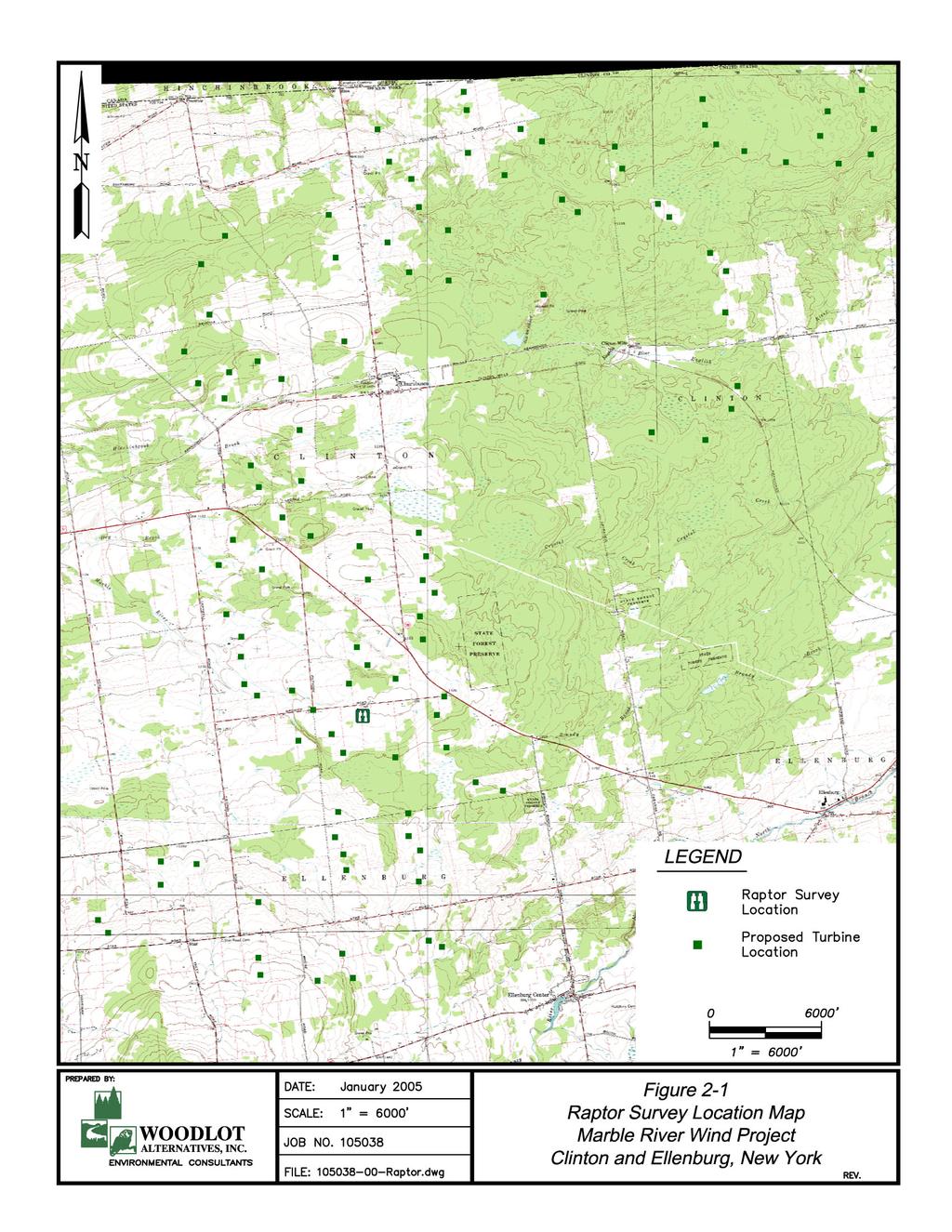
9 Proposed Marble River Wind Project Page Diurnal Raptor Surveys 2.1 Introduction The project area site is located in the northeastern portion of the Central Continental Hawk Flyway that abuts the Eastern Continental Hawk Flyway. Geography and topography are major factors in shaping migration dynamics in this flyway. The northeast to southwest orientation of the northern North American coast and the inland mountain ranges influences hawks migrating in eastern Canada and New England. General raptor migration in the pathway is southwestward to their wintering grounds and northeastward in the spring (Kerlinger 1989, Kellogg 2005). In particular, this site lies to the south of the Canadian border and just north of the Adirondack Mountains whose ridges with their updrafts provide leading lines for migrating hawks to follow. In this way, raptors are able to use the northern ends of ridges or mountains to gain altitude via thermal development or ridge-generated updrafts before gliding as far as possible to another suitable lift site (Kerlinger 1989). During spring migration, raptors fly north over the Adirondack Mountains and encounter a different landscape. The topography of the area changes from mountainous features to a relatively flat and uniform landscape mosaic of farm fields and forests. Due to this lack of mountainous topography, migrating hawks are more dispersed throughout the landscape. Because northern NY lies at the northern range of many species breeding grounds, there are fewer birds passing through this area compared to other more southern locations in the North American hawk flyways. Raptors migrating through northern NY typically migrate over a broad front. Raptor migration through the project area is not as concentrated as in other flyways because long, continuous ridges are not as common at the project site as in other regions of the Central and Eastern Continental Hawk Flyway. Because migration at this site occurs over a broad front, flight lines are more difficult to identify (Street 2003). Woodlot conducted a raptor survey to quantify raptor migration in the vicinity of the proposed project location. Information collected included species, approximate flight height, general direction and flight path, as well as other notable flight behavior. 2.2 Methods Field Surveys Raptor surveys were conducted in a farm field along Gagnier Road in Ellenburg, NY (Figure 2-1). This site, at an elevation of 396 m (1,300 ), provided a view in all directions. The Adirondack Mountains are located due south of the project area. Lyon Mountain (3,803 ), one of the northernmost peaks of the Adirondack Mountains, provides the backdrop for the observation site. To the north, a forested field border slightly obstructs the view. Eastern and western views consisted of farm fields, forest fragments, and distant ridges. Raptor surveys occurred on 10 days from April 5 to May 6, 2005, and were generally conducted from 9 am to 3 pm so as to include the time of day when the strongest thermal lift is produced and the majority of raptor migration activity typically occurs. Surveys were targeted for days with favorable flight conditions produced by low-pressure systems bringing southerly winds and days following the passage of a weather front.
10
11 Proposed Marble River Wind Project Page 6 Surveys were based on methods defined by the HMANA. Observers scanned the sky and surrounding landscape for raptors flying into the survey areas. Observations were recorded onto HMANA data sheets, which summarize the data by hour. Detailed notes on each observation, including location and flight path, flight height, and activity of the animal, were recorded. Height of flight was categorized as less than or greater than 120 m (394 ) above ground, which is the approximate maximum height of the proposed wind turbines. Nearby objects with known heights, such as the met towers and surrounding trees, were used to gauge flight height. Information regarding the raptors behavior and activity at the same locations throughout the study period was noted to differentiate between migrant and resident birds. General flight paths of individuals observed were plotted on topographic maps of the project area. Hourly weather observations, including wind speed, direction, temperature, percent cloud cover, and precipitation, were recorded on HMANA data sheets. Birds that flew too rapidly or were too far to accurately identify were recorded as unidentified to their genus or, if the identification of genus was not possible, they were classified as unidentified raptor. Data Analysis Field observations were summarized by species for each survey day and for the whole survey period. This included a tally of the total number of individuals observed for each species, the observation rate (birds per hour), and an estimate of how many of those observations were suspected to be resident birds. The total number of birds, by species, and by hour, was also calculated as was the species composition of birds observed flying below and above 120 m (394 ). Finally, the mapped flight locations of individuals were reviewed to identify general patterns of migrating raptors. Observations from the project area were compared to other site totals from data from local or regional HMANA hawk watch sites available on the HMANA web site. Those HMANA watch sites included Derby Hill in Mexico, NY, Braddock Bay in Hilton, NY, and Hamburg, NY. 2.3 Results Surveys were conducted for a total of 60 hours during the 10 survey days. A total of 170 raptors, representing 11 1 species, were observed during that time, yielding an overall observation rate of 2.83 birds/hour (Appendix A Table 1; Figure 2-2). Turkey vultures (Cathartes aura) 2 were the most commonly observed species. Red-tailed hawks (Buteo jamaicensis) were the next most abundant species, followed by northern harriers (Circus cyaneus), and then by broad-winged hawks (Buteo platypterus). Nine individuals were not identifiable due either to distance from the observation site or very brief occurrences within the view of the surveyors. These were mostly from the genus Buteo, although one unidentified eagle was observed. One state-listed endangered Golden Eagle (Aquila chrysaetos) was observed. Seventeen state-listed threatened northern harriers were observed. The 4 species of concern observed were 8 Cooper s hawks (Accipiter Cooperi), 13 sharp-shinned hawks (Accipiter striatus), 2 osprey (Pandion haliaetus), and 1 northern goshawk (Accipiter gentilis). No big migration pushes or large kettles of hawks were observed from this site. 1 Additional individuals that were not definitively identified were observed during the survey. While these were likely of the same species documented during the surveys, they have not been used in the calculation of the total number of species observed. 2 While turkey vultures are not true raptors they are diurnal migrants that exhibit flight characteristics similar to hawks and other raptors and are typically included during hawk watch surveys.
12 Proposed Marble River Wind Project Page 7 Most surveys were conducted on clear days when the wind was light to moderate. During the earlier surveys in April, the temperature ranged from 1 to 13º C (35 55º F) while temperatures during surveys in late April and early May ranged from 10 to 21º C (50 70º F). Surveys on most days occurred after the passage of cold fronts. The development of thermals on these days was evident as temperatures increased and cumulus clouds formed. On some of the survey days, visibility was inhibited by morning fog (accompanied by light snowfall one day) that cleared as temperatures and wind speed increased. Some survey effort did occur on days when the weather and wind were sub-optimal for raptor migration due to inaccurate weather forecasting or relatively weak cold fronts. Marble River Raptor Survey Species Composition - Spring 2005 # of birds observed American Kestral Broad-winged Hawk Coopers Hawk Golden Eagle Merlin Northern Goshawk Northern Harrier Osprey Red-tailed hawk Sharp-shinned Hawk Turkey Vulture Unidentified Buteo Unknown Eagle Figure 2-2. Species composition of raptors observed during raptor surveys. This site had 10 probable residential raptors. There were 3 pairs of northern harriers, a pair of red-tailed hawks, and a pair of turkey vultures that may have been residential birds. Red-tailed hawks and northern harriers were frequently observed kiting and hunting over the project areas. Other observations of some American kestrels (Falco sparverius) and sharp-shinned hawks were noted to possibly be repeated sightings of the same individuals. In these cases, a particular individual may have been observed flying back and forth across a section of hillside, performing aerial displays, or perching in an area repeated during the same day. The timing of raptor observations varied during each day. The observation rate of raptors during the survey was approximately 2.83 birds/hour. Typically, observations began slowly, with very few observations occurring during the first hour of the survey period, increased rapidly during the second hour of observation, and decreased again after 12:00 pm (Figure 2-3). This pattern was consistent for most of the species observed in the project area, although on some days a later peak during the last 1 to 2 hours of the day was observed (Appendix A Table 2). Most raptors were observed between the hours of 10:00 and 11:00 am.
13 Proposed Marble River Wind Project Page 8 Marble River Raptor Survey Hourly Observations - Spring # of Birds Observed :00-10:00 10:00-11:00 11:00-12:00 12:00-1:00 1:00-2:00 2:00-3:00 Figure 2-3. Hourly observation rates. Flight heights were categorized as below or above 120 m (394 ), the approximate height of the turbines. Overall, approximately 76 percent of the raptors observed were flying less than 120 m above the ground. Differences in flight altitudes between species were observed (Figure 2-4; Appendix A Table 3). Turkey vultures were frequently observed flying within the blade sweep area. Differences in flight altitudes between species were observed (Figure 2-4; Appendix A Table 3). Both small and large species, such as the accipiters, falcons, and buteos were consistently observed flying low. The most frequently observed species, turkey vultures, had a flight height below 120 m approximately 90 percent of the time. The flight heights of the golden eagle and merlin (Falco columbarius) were both below 120 m. Other species with the majority of flight heights below 120 m included northern harriers, American kestrels and Cooper s hawks. Meanwhile, most flights of broad-winged hawks, northern goshawk, and osprey were above 120 m.
14 Proposed Marble River Wind Project Page 9 Marble River Raptor Survey Flight Height Distribution - Spring # of Birds Observed American Kestral Broad-winged Hawk Coopers Hawk Golden Eagle Merlin Northern Goshawk Northern Harrier Osprey Red-tailed hawk Sharp-shinned Hawk Turkey Vulture Unidentified Buteo Unknown Eagle Figure 2-4. Raptor flight height distribution. > 120 m < 120 m The flight habits of raptors in the project area were variable, though the locations of those observations often occurred in similar locations. Most migrants passing through the project area were flying on a south to north orientation. Many of the birds, particularly red-tailed hawks, northern harriers, and American kestrels, flew in different directions over the observation site and were sometimes observed kiting (hovering over the ground) and hunting over the project area. Individuals believed to be undertaking long-distance migratory movements (most of the raptors observed) had much more direct flight paths (S to N). Northern harriers were occasionally observed flying low over fields and in various directions suggesting a resident bird. The general locations of migrating raptors observed are depicted in Figure 2-5. Raptor migration at Marble River occurred over a broad front; hence, migration pathways were not easily identifiable. Raptors flew distributed across the study area but two major and five minor flyways have been generalized. Most flyways were on an S-N orientation and most flights were over forested areas. However, some of the minor flyways occurred over farm fields. There were no differences in flight heights between the major and minor flyways.
15
16 Proposed Marble River Wind Project Page Discussion A total of 170 migrating raptors were observed during 10 days of field surveys from April to May 2005 at Marble River site. Eleven different species were recorded with an observation rate of 2.83 birds/hour. Turkey vultures were the most abundant species observed and comprised approximately 42 percent of all observations. Red-tailed hawks comprised 15 percent of observations. One state-listed endangered species (golden eagle), 1 state-listed threatened species (northern harrier), and 4 species of concern (northern goshawk, Cooper s hawk, osprey, and sharp-shinned hawk) were observed migrating through the project area. Broad-winged hawks were usually observed in pairs and no large kettles of broadwinged hawks were reported during the study. Most birds observed were considered migrants, although several may have been residential birds based on their activity and behavior. Golden eagles, red-tailed hawks, northern harriers, Cooper s hawks, sharp-shinned hawks, and turkey vultures were the first raptors observed in early April. Ospreys were the last species to migrate through the study site. Two species of raptors (northern harrier and red-tailed hawk) were believed to be paired and local residential birds. For this site, passage rates are relatively low compared to other sites in the region, where raptor migration surveys were conducted during the same timeframe (spring 2005). Observation rates at other NY sites ranged from 33 to 69 (birds/hour). There could be several reasons for the greater passage rates, including survey effort, geographical location, and visibility. The most active site was Derby Hill in Mexico, NY, with a total of 23,623 raptors counted (61.1 birds/hour). At Braddock Bay in Hilton, NY, 30,793 birds (68.8 birds/hour) were observed. In Hamburg, NY, 13,141 raptors (33.2 birds/hour) were observed. These areas may have very different landscape features (proximity to large bodies of water) than this project, but offer comparative regional information on raptor migration. Survey effort varies from site to site. Hawkwatch locations are usually surveyed when the weather is optimal for raptor migration and typically during the peak of the migration season. This level of effort increases observation rates because relatively few hours of survey time are being targeted for the time periods when the majority of birds are migrating. However, there are various peak migration periods for different species. Hence, the rational for sampling across an extended sampling period is to observe each individual species during their peak flight (March through May). Alternatively, sampling only during sub-optimal migration weather would decrease observation rates. During the surveys completed at the project site, several days with sub-optimal migration weather (north winds) were sampled and fewer hawks were typically observed on those days. Geographical location can affect the magnitude of raptor migration at a particular site. Two well-known examples include Cape May, NJ, and Hawk Mountain, PA. The location of these sites relative to large, regional landscape features result in large concentrations of migrating raptors. This likely happens at a smaller scale, as large river valleys and dominant ridgelines might result in more suitable migration conditions (i.e., strong thermal development, crosswinds, and updrafts). Organized hawk count locations typically target these areas of known, concentrated raptor migration activity. The nearby sites for which data is available (Appendix A, Table 4) are demonstrative of this situation. Visibility at a site can affect results of raptor surveys. The most ideal hawk migration sites often provide wide, open views of not only the surrounding airspace, but also the surrounding slopes and ridgelines. These sites include open mountaintops, cleared land on mountain peaks, very steep topography such as the top of a cliff, and sometimes observation towers. These views downward and over the surrounding hillsides are often needed to observe those species that hug hillsides and migrate at lower altitudes, such as sharp-shinned hawks, merlins, and American kestrels. During migration, raptors hunt along their migration pathway and these hillsides provide both cover and thermal lift.
17 Proposed Marble River Wind Project Page 12 The flight heights of raptors observed in the project area indicate that birds migrated within the bladeswept area of the proposed turbines. Approximately 76 percent of raptors were observed flying below 120 m (394 ). There were differences between species, generally with accipiters, falcons, and most buteos flying at lower altitudes. Generally, smaller species were observed at lower flight altitudes. Broad-winged hawks and osprey were most frequently observed migrating above the height zone of proposed wind turbines at the site. Overall, it may be easier to detect large species flying at low and high altitudes; therefore, smaller species may sometimes be underrepresented (Kerlinger 1989). Migration of raptors is a dynamic process due to various internal and external factors. Flight pathways and their movements along ridges, slide slopes, and across valleys may vary. Raptors may shift and use different ridge lines and cross different valleys from year to year or season to season. Weather and wind are big factors that influence migration pathways. The flight paths of raptors observed in the project area varied between survey dates and were influenced by varying wind direction and weather. Wind strongly affects the propensity to concentrate raptors along linear features (such as rivers and ridges). The precise location of the migrants relative to the linear feature are what helps create concentrations of migrating birds along linear features and can be related to lateral drift caused by crosswinds (Richardson 1998). There were no detectable differences in flight heights between major and minor flight pathways. Broad movements of raptors in the project area were observed. On some days, raptors were observed flying both north and south. This could be attributed to migrants overshooting their breeding grounds or presence of residential birds moving across the study area. 2.5 Conclusions The results of the field surveys indicate that fall raptor migration in the Marble River project area is low relative to other sites in the region. This is likely due to a lack of large landscape features that could concentrate migration activity at the project area. Rather, the surrounding landscape consists of a series of interrupted hillsides, valleys, and individual peaks that migrating raptors use as stepping stones as they pass through the area. There is potential that some of the birds observed may have not demonstrated characteristics of resident species. Resident birds fly at lower heights than migrants, as they are typically undertaking small-scale movements while foraging. There is potential that many of the turkey vultures observed are resident birds. There are a consistent number of turkey vultures observed in the mornings on each of the survey days. It cannot be determined what percentage of these birds are migrants as opposed to local birds engaging in daily dispersal patterns. Migrants observed passing through the project area flew higher than resident birds. These birds were taking advantage of thermals and crosswinds flowing up hillsides and out of valleys. Consequently, they were consistently observed gaining altitude in these areas before following straight flight paths north. Based on the flight paths of migrants observed, it is likely that the central paths of the fields, where most wind turbines are being proposed, receive low use by migrating raptors. The majority of birds follow valleys, ridgelines, and side slopes that develop stronger thermals and crosswinds for migration; however, this site lacks those landscape features and migrants move across the landscape in inconsistent patterns. This observation site had low to moderate numbers and diversity of migrating hawks. Raptors observed during the study were seen flying low when crossing fields. This behavior may be a potential concern for the project site due to the non-continuous ridges of the northern-ny landscape and the behavior of migrating raptors.
18 Proposed Marble River Wind Project Page Nocturnal Radar Survey 3.1 Introduction The vast majority of North American landbirds migrate at night. The strategy to migrate at night may be to take advantage of more stable atmospheric conditions for flapping flight (Kerlinger 1995). Conversely, species using soaring flight, such as raptors, migrate during the day to take advantage of warm rising air in thermals and laminar flow of air over the landscape, which can create updrafts along hillsides and ridgelines. Additionally, night migration may provide a more efficient medium to regulate body temperature during active, flapping flight, and could reduce the potential for predation while in flight (Alerstam 1990, Kerlinger 1995). Collision with unseen obstacles is a potential hazard to nocturnally migrating birds. Additionally, some lighted structures may actually attract birds to them under certain weather conditions, which can be associated with collision or exhaustion of birds, both of which often result in mortality (Ogden 1996). For example, birds have been documented colliding with tall structures, such as buildings and communication towers, particularly when weather conditions are foggy (Crawford 1981; Avery et al. 1976, 1977). Wind turbines also pose a potential threat to migrating birds as they are relatively tall structures, have moving parts, and may be lit, depending on their height and location (Erickson et al. 2000). Factors that could affect potential collision risk of nocturnally migrating birds by wind turbines can include weather, magnitude of migration, height of flight, and movement patterns in the vicinity of a wind project, along with the height of turbines and other site-specific characteristics of a wind project. Radar surveys were conducted at the Marble River project area to characterize spring nocturnal migration patterns in the area. The goal of the surveys was to characterize the overall passage rates for nocturnal migration in the vicinity of the project area, including the number of migrants, their flight direction, and their flight altitude. This information will be used to help evaluate the potential effect of the proposed wind energy facilities on local and migrating avian populations. 3.2 Methods Field Methods A single marine surveillance radar similar to that described by Cooper et al. (1991) was used during field data collection. A Furuno FR1510-MKIII radar was mounted atop a platform approximately 4 m (13 ) above the ground. The radar display and all other equipment were stored and used in a mobile radar station. The radar has a peak power output of 12 kw and has the ability to track small animals, including birds, bats, and even insects, based on settings selected for the radar functions. It cannot, however, readily distinguish between different types of animals being detected. Consequently, all animals observed on the radar screen are called targets. To detect small targets such as birds and bats, the radar s anti-rain and anti-sea settings were turned down and the gain was turned up. The radar was operated at its shortest pulse length to increase the detection of small targets. The radar has an echo trail function that maintains past echoes of trails. This function has several time periods that can be used, after which echoes are
19 Proposed Marble River Wind Project Page 14 successively erased from the radar screen. During all operations, the radar s echo trail was set to 30 seconds. The radar was equipped with a 2-m (6.5 ) waveguide antenna. The antenna has a vertical beam height of 20º (10º above and below horizontal) and the front end of it was inclined approximately 5º to increase the proportion of the beam directed into the sky. The radar unit was located centrally on the site in an area that both maximized site characterization and objects on the ground detected by the radar cause returns on the radar screen (echoes) that appear as blotches called ground clutter. Large amounts of ground clutter reduce the ability of the radar to track birds and bats flying over those areas. The radar unit was positioned on the edge of a field and atop a 4 m (13 ) tall platform to minimize the amount of ground clutter and maximize ability to detect targets. The radar was operated in two modes for each survey hour. In the first (surveillance) mode, the antenna spins horizontally to survey the airspace around the radar and detects targets moving through the area. By analyzing the echo trail, the number, flight direction, and speed of targets can be determined. In the second (vertical) mode of operation, the antenna is rotated 90º to vertically survey the airspace above the radar (Harmata et al. 1999). In vertical mode, target echoes do not provide directional data, but instead provide information on the altitude of targets passing through the vertical, 20º radar beam. The radar was operated at a range of 1.4 km (0.75 nautical miles). At this range, the echoes of small birds can be easily detected, observed, and tracked. At greater ranges, larger birds can be detected, but the echoes of small birds are reduced in size and restricted to a smaller portion of the radar screen, thereby reducing the ability to observe the movement pattern of individual targets. The geographical limits of the range setting used are depicted in Figure 3-1. Radar surveys were conducted from sunset to sunrise. Thirty-nine nights of surveys were conducted between April 15 and May 29, Because the anti-rain function of the radar must be turned down to detect small songbirds and bats, surveys could not be conducted during periods of inclement weather. Therefore, surveys were targeted largely for nights without rain. However, to characterize migration patterns during nights without optimal conditions, some nights with weather forecasts including occasional showers were sampled. The operation of the radar for each survey night is presented in Table 3-1.
20
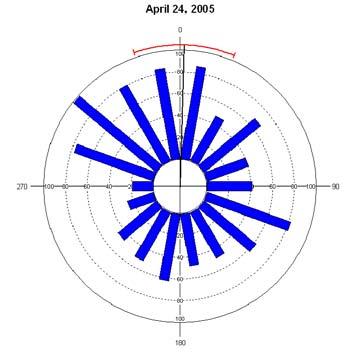
21 Proposed Marble River Wind Project Page 16 Table 3-1. Survey dates, level of effort, and weather Marble River, Spring 2005 Night of Sunset Sunrise Hours of Survey Weather Wind Direction (coming from) April 15 7:42 PM 6:15 AM 9 calm and clear SE April 16 7:44 PM 6:13 AM 4 calm and clear S April 17 7:45 PM 6:12 AM 9 breezy then calm, partly cloudy SW April 18 7:46 PM 6:10 AM 11 calm and clear SW April 19 7:47 PM 6:09 AM 9 breezy with some rain SW April 21 7:49 PM 6:06 AM 11 calm and clear SW April 22 7:50 PM 6:04 AM 2 light wind, cloudy SE April 24 7:53 PM 6:01 AM 6 cloudy, light wind, some rain and light snow W April 29 7:58 PM 5:54 AM 10 calm, clear then cloudy SW April 30 8:00 PM 5:53 AM 7 light wind, cloudy and foggy W to SW May 1 8:01 PM 5:51 AM 10 breezy and partly cloudy SW May 2 8:02 PM 5:50 AM 10 breezy then calm, mostly clear SW May 3 8:03 PM 5:49 AM 10 calm and clear then cloudy, passing showers late SW May 4 8:04 PM 5:47 AM 10 calm and clear SW May 5 8:05 PM 5:46 AM 10 calm and clear SE May 6 8:06 PM 5:45 AM 9 calm and clear SE May 7 8:07 PM 5:44 AM 10 breezy and partly cloudy NE May 8 8:09 PM 5:42 AM 9 calm and cloudy NE May 9 8:10 PM 5:41 AM 10 light wind and clear SE May 10 8:11 PM 5:40 AM 10 calm then breezy, clear then cloudy SE to SSW May 11 8:12 PM 5:39 AM 8 cloudy with heavy gusts and rain showers NW May 12 8:13 PM 5:38 AM 8 calm and clear NW to S to N May 13 8:14 PM 5:37 AM 8 calm, cloudy with passing showers late SE to S May 14 8:15 PM 5:36 AM 4 light wind, cloudy SE May 15 8:16 PM 5:35 AM 5 light wind, cloudy, some rain W May 16 8:17 PM 5:34 AM 10 calm, cloudy, passing rain showers SW to W May 17 8:18 PM 5:33 AM 10 calm, cloudy W to SW May 18 8:19 PM 5:32 AM 10 calm, partly cloudy N May 19 8:20 PM 5:31 AM 8 calm and cloudy SE May 20 8:21 PM 5:30 AM 7 Not available n/a May 21 8:22 PM 5:29 AM 5 Not available n/a May 22 8:23 PM 5:28 AM 2 breezy, cloudy with light rain NE May 23 8:24 PM 5:27 AM 7 strong winds, cloudy with gusts E to NE May 24 8:25 PM 5:27 AM 9 light wind, partly cloudy E May 25 8:26 PM 5:26 AM 9 light wind, clear SE May 26 8:27 PM 5:25 AM 7 breezy then calm, cloudy, some rain NE May 27 8:28 PM 5:25 AM 3 light wind, cloudy, misty and raining NW May 28 8:29 PM 5:24 AM 6 light wind and partly cloudy SW May 29 8:30 PM 5:23 AM 8 light wind, mostly cloudy, light rain early S Note: Additional nights of survey were attempted but foul weather prevented the initiation of surveys.
22 Proposed Marble River Wind Project Page 17 Data Collection The radar display was connected to video recording software of a computer. During surveillance mode, 15 one-minute samples of the radar display were recorded for each survey hour. During vertical mode, a single 10-minute video sample was recorded for each survey hour. The video samples were recorded on the following schedule for each 1-hour period after sunset: Seven 1-minute samples during the first 15 minutes after sunset; One 10-minute vertical sample during the next 30 minutes; and Eight 1-minute samples during the last 15 minutes of the hour. During the 30-minute period when vertical data were recorded, additional information was also recorded, including weather observations and ceilometer observations. Weather data recorded included wind speed and direction, cloud cover, temperature, and precipitation. Ceilometer observations involved directing a one million candlepower spotlight vertically into the sky in a manner similar to that described by Gauthreaux (1969). The ceilometer beam was observed by eye for 5 minutes to document and characterize low-flying targets. The ceilometer was held in-hand so that any birds, bats, or insects passing through it could be tracked for several seconds, if needed. On nights with a full moon and clear skies, the ceilometer beam was too diffuse to readily detect birds and bats. On those nights, moonwatching (Lowery 1951) was used, which involved watching the face of the moon with binoculars for 5 minutes and recording any observations of birds or bats flying in front of the moon. Observations from each ceilometer or moonwatching period were recorded by hand, including the number of birds, bats, and insects observed. This information was used during data analysis to help distinguish between insects from bird and bat targets. Data Analysis The video samples were analyzed using a digital video analysis software tool developed by Woodlot. For horizontal samples, targets were identified as birds and bats rather than insects based on their speed. The speed of targets was compared with wind speed and direction; targets traveling faster than approximately 6 m per second were identified as a bird or bat target. The software tool recorded the time, location, and flight vector for each target traveling fast enough to be a bird or bat. The results for each sample were output to a spreadsheet. For vertical samples, the software tools recorded the entry point of targets passing through the vertical radar beam, the time, and flight altitude above the radar location. The results for each sample were output to a spreadsheet. These datasets were then used to calculate passage rate, flight direction, and flight altitude of targets. Hourly passage rates (in 1-hour increments post sunset) were calculated by tallying the total number of targets in the 1-minute samples for each hour and correcting for the number of samples collected in that hour. That estimate was then corrected for the radar range setting that was used in the field and was expressed as targets/km/hour (t/km/hr) ± 1 SE. The hourly rates were used to calculate passage rates for each night and the entire season. Mean target flight directions (± 1 circular SD) were summarized in a similar manner: by hour, night, and for the entire season. Flight direction analysis and statistical analyses were conducted using software designed specifically to analyze directional data (Oriana2 Kovach Computing Services). The statistics used in this program are based on Batschelet (1965), which take into account the circular nature of the data. Nightly wind direction was also calculated using similar methods from data collected from the central met tower, near the radar site. Mean wind speed was calculated using linear statistics (Zar 1999).
23 Proposed Marble River Wind Project Page 18 Flight altitude data were summarized using linear statistics. Mean flight altitudes (± 1 SE) were calculated by hour, night, and overall season. The percent of targets flying below 120 m (394 ) (the approximate maximum height of proposed wind turbines) was also calculated hourly, for each night, and for the entire survey period. 3.3 Results Radar surveys were conducted during 310 hours on 39 nights between April and May 2005 (Table 3-1). The radar site provided generally good visibility of the surrounding airspace and targets were observed in most areas of the radar display unit. The radar site had good views to the south and east. The western view was slightly obstructed by a low-lying forested wetland. Passage Rates A total of 780 one-minute radar video samples were analyzed during the passage rate and flight direction analysis and included a total of 8,221 targets. Nightly passage rates varied from 3 ± 3 t/km/hr (May 22) to 728 ± 136 t/km/hr (April 22), and the overall passage rate for the entire survey period was 254 ± 45 t/km/hr (Figure 3-2; Appendix B Table 1). On nights with highest observed passage rates, the wind was typically from the southwest to southeast. During rainy nights, only certain hours could be sampled. However, most survey nights had a least 10 hours of survey time. During inclement weather, researchers were able to record at least 2 hours of data per night. Targets/km/hr Marble River Nightly Passage Rates - Spring 2005 April 15 April 16 April 17 April 18 April 19 April 21 April 22 April 24 April 29 April 30 May 1 May 2 May 3 May 4 May 5 May 6 May 7 May 8 May 9 May 10 May 11 May 12 May 13 May 14 May 15 May 16 May 17 May 18 May 19 May 20 May 21 May 22 May 23 May 24 May 25 May 26 May 27 May 28 May 29 Night of Figure 3-2. Nightly passage rates (error bars = 1 SE) observed.
24 Proposed Marble River Wind Project Page 19 Individual hourly passage rates throughout the entire season varied from 3 to 728 t/km/hr (Appendix B Table 1). Hourly passage rates varied throughout each night and for the season overall. For the entire season, passage rates were highest during the fourth and fifth hour after sunset, followed by a relatively steady decline for the remainder of the night (Figure 3-3). Marble River Hourly Passage Rate - Spring Targets/km/hr Hours after Sunset Figure 3-3. Hourly passage rates for entire season. Flight Direction Mean flight direction through the project area was 40º ± 66º (Figure 3-4; Appendix B Table 2). There was considerable night to night variation in mean direction, although within each night there was less variation (Figure 3-5). The average nightly flight direction was typically northeast on more than half of the nights sampled.
25
26
27
28
29
30 Proposed Marble River Wind Project Page 25 Flight Altitude The mean flight height of all targets was 422 m ± 54 m (1,384 ± 177 ) above the radar site. The average nightly flight height ranged from 172 m ± 37 m (564 ± 121 ) to 831 m ± 23 m (2,726 ± 75 ) (Figure 3-6, Appendix B Table 3). The percent of targets observed flying below 120 m (394 ) also varied by night, from 0 percent to 47 percent (Figure 3-7). The seasonal average percentage of targets flying below 120 m (394 ) was 11 percent. Hourly flight height peaked from about 2 hours after sunset (Figure 3-8). Within 100 m (328 ) height zones, the greatest percentage of targets (16%) was documented from 200 m to 300 m (656 to 984 ), 54 percent were observed from 200 m to 700 m (656 to 2,297 ), and 75 percent were observed from 100 m to 800 m (328 to 2,625 ) above the radar site (Figure 3-9) Marble River Mean Nightly Flight Height - Spring 2005 Mean flight Height = 425 m Max Turbine Height = 120 m 600 Altitude (m) April 15 April 16 April 17 April 18 April 19 April 21 April 22 April 24 April 29 April 30 May 1 May 2 May 3 May 4 May 5 May 6 May 7 May 8 May 9 May 10 May 11 May 12 May 13 May 14 May 15 May 16 May 17 May 18 May 19 May 20 May 21 May 22 May 23 May 24 May 25 May 26 May 27 May 28 May 29 Night of Figure 3-6. Mean nightly flight height of targets.
31 Proposed Marble River Wind Project Page 26 Marble River Percent of Targets Below 120 m - Spring 2005 Percent of Targets 50% 45% 40% 35% 30% 25% 20% 15% 10% 5% 0% April 15 April 16 April 17 April 18 April 19 April 21 April 22 April 24 April 29 April 30 May 1 May 2 May 3 May 4 May 5 May 6 May 7 May 8 May 9 May 10 May 11 May 12 May 13 May 14 May 15 May 16 May 17 May 18 May 19 May 20 May 21 May 22 May 23 May 24 May 25 May 26 May 27 May 28 May 29 Night of Figure 3-7. Percent of targets observed flying below a height of 120 m (394 ). Marble River Hourly Flight Height - Spring Mean Flight Height (m) Hours after Sunset Figure 3-8. Hourly target flight height distribution.
32 Proposed Marble River Wind Project Page 27 Marble River Target Flight Altitude Distribution - Spring % 16% 14% Percent of Targets 12% 10% 8% 6% 4% 2% 0% m m m m m m m m m m m m m m m m m m Altitude zone Figure 3-9. Target flight height distribution within 100 m height zones. Ceilometer Observations Ceilometer data collected during the radar survey yielded a total of 254 observations. Those observations, as is typical, resulted in relatively few bird observations. Only five birds were observed flying through the ceilometer beam. 3.4 Discussion Spring 2005 radar surveys documented migration activity and patterns in the vicinity of the proposed Marble River project area. In general, migration activity and flight patterns varied between and within nights. Nightly variation in the magnitude and flight characteristics of nocturnally-migrating songbirds is not uncommon and is often attributed to weather patterns, such as cold fronts and winds aloft (Hassler et al. 1963, Gauthreaux and Able 1970, Gauthreaux 1971, Richardson 1972, Able 1973, Bingman et al. 1982, Gauthreaux 1991). Passage Rates As indicated above, weather patterns are probably the largest factor affecting the magnitude of bird migration, particularly at inland sites. In the spring, an approaching low pressure system typically produces light southerly winds from the west or southwest. Bird migration is often more abundant during these periods because of favorable wind direction for spring migration (Richardson 1972). Consequently, nightly migration traffic rates can be expected to be variable and to peak when the best migration weather occurs. The variable nightly passage rates documented at Marble River are consistent with this. For example, passage rates were generally higher on clear nights, which were typically associated with colder
33 Proposed Marble River Wind Project Page 28 temperatures. Passage rates were variable on cloudy nights and generally low on nights with fog and passing showers, indicative of the role that weather can play in bird migration activity. Nightly passage rates varied from 3 ± 3 t/km/h to 728 ± 136 t/km/hr, with an overall mean of 254 ± 45 t/km/hr. Passage rates often peaked 5 hours after sunset, which is later than typical time of nighttime migration activity of 3 to 4 hours after sunset (Able 1970; Gauthreaux 1971; Richardson 1971, 1972). Few surveys using the same methods and equipment and conducted during the same time period are available for comparison (Table 3-2). In a similar study overlooking Lake Erie in western NY, Cooper et al. (2004a) documented spring 2003 passage rates between 15 and 1,702 t/km/hr with an overall passage rate of 395 t/km/hr. There are limitations in comparing that study with data from 2005, as year-to-year variation in continental bird populations invariably affects how many birds migrate through an area. However, nightly mean passage rates observed at Marble River were within the range of those studies. Differences in the overall passage rates could be due to several factors. First, surveys conducted during different years can yield different results, as the sizes of continental bird populations are likely change from year-to-year. Second, the location of the Marble River project is more easterly than that survey. Consequently, the size of the continental bird population east of Lake Erie could be considerably smaller than other sites. Table 3-2. Summary of regional spring migration studies using radar (Cooper et al. 2004a) Location Passage Rate Chautauqua, NY 395 Copenhagen, NY 170 Wethersfield, NY 62 Finally, the visibility of the radar also affects passage rates documented during surveillance mode operation. Whenever energy is reflected from the ground, surrounding vegetation, and other objects that surround the radar unit, a ground-clutter echo appears on the display screen of the radar unit. Ground clutter can obscure part of the display screen thus obscuring bird targets. This occurrence was minimized by elevating the forward edge of the antenna by approximately 5º. Flight Direction Some research suggests that bird migration may be affected by landscape features, such as coastlines, large river valleys, and mountain ranges. This has been documented for diurnally-migrating birds, such as raptors, but is not as well established for nocturnally migrating birds (Sielman et al. 1981, Bingman et al. 1982, Bruderer and Jenni 1990, Richardson 1998, Fortin et al. 1999, Williams et al. 2001, Diehl et al. 2003, Woodlot unpublished data). Evidence suggesting topographic effects to night-migrating birds has typically included areas of varied topography, such as the most rugged areas of the northern Appalachians and the Alps. The landscape around the Marble River project area consists of plains and peaks with elevation differentials of 90 m to 260 m (300 to 850 ). This is considerably less than in those other areas where potential topographic effects on flight direction have been observed. The mean flight direction of 40º ± 66º generally comes from the direction of the high peaks of the Adirondack Park.
34 Proposed Marble River Wind Project Page 29 Flight Height The altitude at which nocturnal migrants fly has been one of the least understood aspects of bird migration. Bellrose (1971) flew a small plane at night along altitudinal transects to visually document the occurrence and altitude of migrating songbirds. He found the majority of birds observed were between 150 m (492 ) and 450 m (1,476 ) above the ground level, but on some nights the majority of birds observed were from 450 m (1,476 ) to 762 m (2,500 ) above the ground. Radar studies have largely confirmed those visual observations, with the majority of nocturnal bird migration appearing to occur less than 500 m (1,640 ) to 700 m (2,296 ) above the ground (Able 1970, Alerstam 1990, Gauthreaux 1991, Cooper and Ritchie 1995). Recent studies at other proposed wind facilities in the Northeast and Mid-Atlantic states are consistent with this as well. Cooper et al. (2004a) documented a mean overall flight altitude of 528 ± 3 m during a spring migration survey in Chautauqua, NY. The highest percentage (36 %) of migrants was documented 300 m (984 ) to 600 m (1,968 ) above the ground and the smallest percentage (0.1%) above 1,401 m. In the fall at Chatauqua, Cooper et al. (2004b) documented a mean flight altitude of 532 m (1,745 ) with a small percentage (4%) of targets flying less than 125 m (410 ) above the ground. Results from Marble River are similar to those of Cooper et al. (2004a), with nightly flight altitudes varying from 172 m ± 37 m (564 ± 121 ) to 831 m ± 23 m (2,726 ± 75 ) and a mean of 422 m ± 54 m (1,384 ± 177 ). The percentage of targets flying less than 120 m (394 ) above the ground was low, 11 percent, similar to that found by Cooper et al. (2004b). The high mean flight altitude of targets documented during this study likely further supports the presumption that topographic features are not affecting migration patterns, particularly flight direction. Because mean flight altitude is above the radar, it is likely that most birds are flying at a height that is unimpeded by topographic features, such as hillsides or mountaintops, as they pass over valleys, ridges, and mountaintops. 3.5 Conclusions Radar surveys during the spring 2005 migration period have provided important information on nocturnal bird migration patterns in the vicinity of the Marble River project area. The results of the surveys indicate that bird migration patterns are generally similar to patterns observed at other proposed wind power sites being assessed in the region. Migration activity varied throughout the season, which is probably largely attributable to weather patterns. The mean passage rate (254 ± 45 t/km/hr) is lower than that observed at similar studies. Migration activity throughout each night typically peaked 5 hours after sunset. Nightly passage rates varied from 3 ± 3 t/km/hr to 728 ± 136 t/km/hr. Mean flight direction for the entire season was 40º ± 60 º. Flight direction data indicate that nocturnal migrants are not avoiding the project area for any topographic-related reasons and that migrants appeared to be coming from the direction of the high peaks of the Adirondack Mountains. The average flight altitude above the ground was 422 m ± 54 m (1,384 ± 177 ). There were 11 percent of the targets observed during vertical radar operation that flew below an altitude of 120 m (394 ), the maximum height of the proposed turbines, indicating that risk of collision to night-migrating birds is limited to a subset of those birds.
35 Proposed Marble River Wind Project Page 30 Risk to nocturnally-migrating birds is known to occur, particularly during periods of inclement weather that can force birds to fly at lower heights and decrease night-time visibility. Lower flight altitudes were observed during cloudy, foggy, and rainy nights in the project area. Those nights, however, were typically associated with low to very low nightly passage rates.
36 Proposed Marble River Wind Project Page Bat Survey 4.1 Introduction Wind projects have been cited as a potential threat to migrating bats for a number of years, especially since a study at the Mountaineer Wind Energy Facility in Tucker County, WV, documented 475 dead bats between April 20 and November 9, 2003 (Johnson and Strickland 2004). Subsequent fieldwork in 2004 at the Mountaineer site and nearby Meyersdale Wind Facility has revealed even higher rates of bat collision mortality with operating wind turbines (Arnett et al. 2005). These studies have raised numerous concerns regarding the potential for collision mortality associated with wind turbines to impact bat populations (Williams 2003). The concerns lie primarily with wind farms in the eastern United States, where documented bat fatality rates have been considerably higher (bats per turbine per year) than at western wind farms (Williams 2003, Arnett et al. 2005). Researchers currently have limited understanding of the specific factors influencing rates of bat collision mortality, although evidence from the timing of fatalities documented at existing wind facilities and other structures suggests that migrating bats are at the highest risk (Johnson and Strickland 2004, Johnson et al. 2003, Whitaker and Hamilton 1998). A number of plausible hypotheses explaining the high rates of bat mortality have been presented by bat researchers, but none of these have been adequately tested. The most likely mechanisms explaining bat collision center on the possibility that ridges act as corridors for migrating or feeding bats, that bats are unable to detect turbines visually or by echolocation, or that bats may be attracted to wind turbines due to artificially high insect concentrations, light attraction, or acoustic attraction (Arnett et al. 2005). Nine species of bats occur in NY, based upon their normal geographic range. These are the little brown myotis (Myotis lucifugus), northern myotis, (M. septentrionalis), Indiana myotis (Myotis sodalis), Eastern small-footed myotis (M. leibii), silver-haired bat (Lasionycteris noctivagans), Eastern pipistrelle (Pipistrellus subflavus), big brown bat (Eptesicus fuscus), Eastern red bat (Lasiurus borealis), and hoary bat (L. cinereus) (Whitaker and Hamilton 1998). Of these, the Indiana myotis is listed as federally endangered, and the small-footed bat is listed as a special concern species by the state of NY. According to the NYDEC, eight Indiana myotis hibernacula are present in NY, located in Albany, Essex, Jefferson, Onondaga, Ulster, and Warren counties (NYDEC website, accessed 8/4/05). Marble River is located in northern Clinton County, which borders Essex County to the south. Depending upon the precise location of the hibernacula within Essex County, Marble River is roughly 30 to 60 miles removed to the north. To document bat activity in the area of the proposed wind facility, Woodlot conducted bat surveys in spring 2005, between April 14 to May 13. Acoustic surveys using Anabat II detectors (Titley Electronics Pty Ltd) were the primary survey type used in this study and were designed to document bat passage rates near the rotor zone of the proposed turbines. Visual ceilometer surveys were also conducted in spring 2005, concurrent with nocturnal radar surveys.
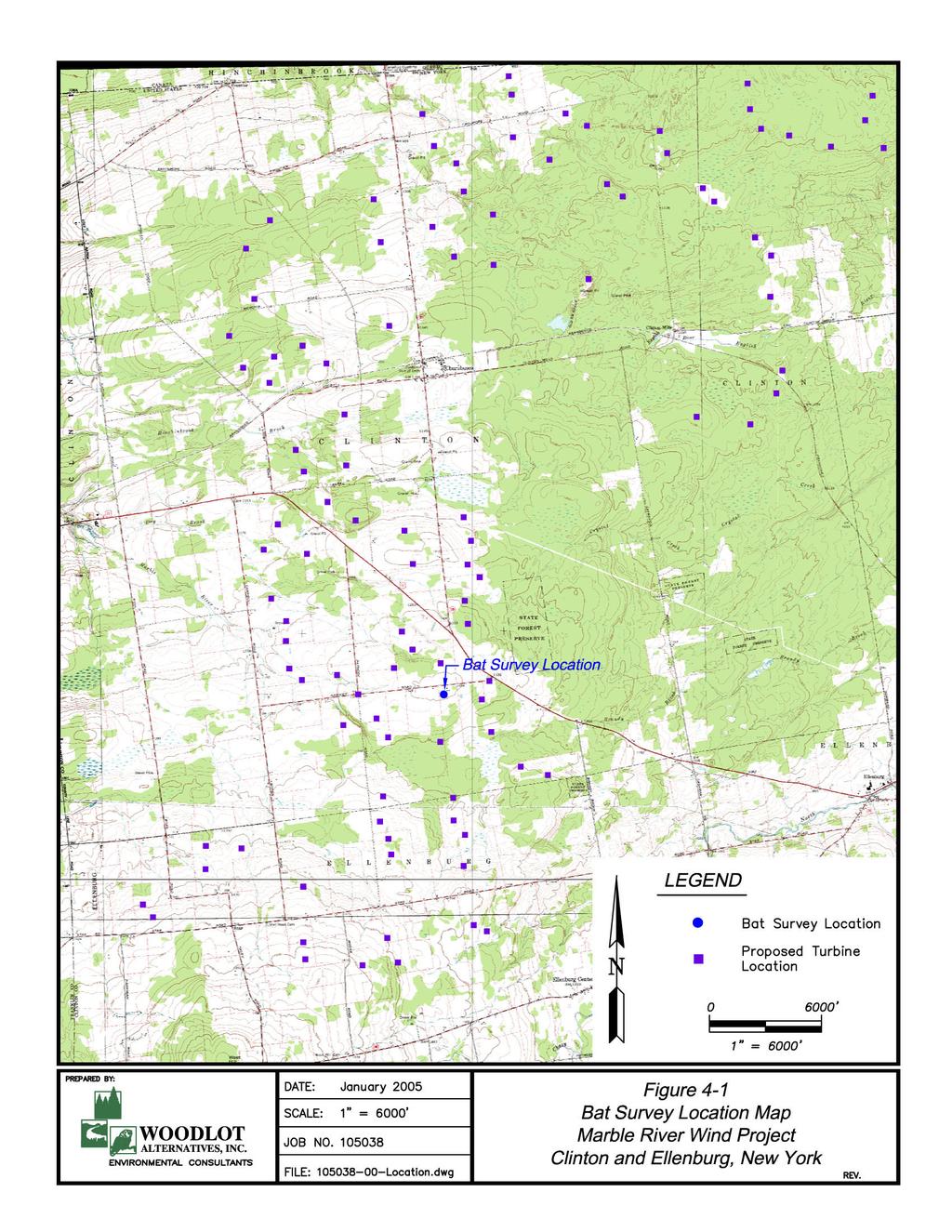
37 Proposed Marble River Wind Project Page Methods Field Surveys Anabat II detectors were used for the duration of this study. Anabat detectors are frequency-division detectors, dividing the frequency of ultrasonic calls made by bats (a factor of 16 was used in this study 3 ) so that they are audible to humans. These detectors are able to detect all bat species known to occur in New England using this setting. Data from the Anabat detectors were logged onto compact flash media using a CF ZCAIM (Titley Electronics Pty Ltd) and downloaded to a computer for analysis. The acoustic surveys were designed primarily to document the occurrence and detection rates of bats near the low end of the blade-swept area of the proposed turbines. To do this, an Anabat II detector was suspended from the guy wires of a meteorological tower (met tower) at the Marble River site, near the location where radar surveys occurred (Figure 4-1). The detector was suspended in a weatherproof box at heights of approximately 15 m (49 ) and 30 m (100 ) on the met tower guy wires (Figure 4-2). The detector was programmed to activate from sunset to sunrise resulting in approximately 10 hours of sampling per detector per night. Data Analysis Call files were extracted from data files using CFCread software, with default settings in place. Nightly tallies of detected calls were compiled for each detector. Mean detection rates (calls/hour and calls/night) were calculated for each night. These were summarized by time period within the migration season and detector location (15 m or 30 m high in the met tower). Detection rates indicate only the number of calls detected, and do not necessarily reflect the number of individual bats in an area. Ultrasonic calls of bats are attenuated quickly by the atmosphere, and are only able to travel limited distances, depending upon their frequency (Griffin 1970, 1971). Also, Anabat detectors have a limited range of roughly 10 m to 15 m (30 to 50 ). This was confirmed at the beginning of the survey period using an artificial bat chirp (Tony Messina) device and field tests with flying bats. Consequently, the height of bat calls recorded by the detectors deployed in the met tower was assumed to be roughly that of the detector that recorded the bat. In addition to documenting passage rates, acoustic surveys with Anabat II detectors allow for limited species identification (O Farrell and Gannon 1999). Because bat calls vary widely within species, and are influenced by habitat and region, definitive species identification based upon acoustic monitoring alone is not always possible. However, several of the species that are present in this area have calls that appear distinct when recorded with the Anabat system. 3 The frequency division setting literally divides ultrasonic calls detected by the detector by the division setting in order to produce signals at frequencies audible to the human ear.
38
.")
39 Proposed Marble River Wind Project Page 34 Figure 4-2. Photo of bat detectors set at 15 and 30 meters in met tower. Qualitative visual comparison of recorded call sequences of sufficient length to reference libraries of bat calls allows for relatively accurate identification of bat species (O Farrell et al. 1999). Calls recorded during the survey were compared to reference calls compiled by Chris Corben, the designer of the Anabat II software used in this study, and data from the University of Maine Mammalogy Department. These reference calls were of western and northeastern origin and served as a basis for differentiating the calls that were recorded. Recorded calls were classified based upon the shape of the call sequence, the slope, and the maximum and minimum frequencies. Calls with insufficient material upon which to determine the species were classified as unknown. Because some calls within the Myotis genus are so similar, many were identified to the genus level. Ceilometer Surveys As noted in Section 3.2, ceilometer surveys took place for 5 minutes during each hour of radar sampling. While species identification was not possible, targets were classified as either bats or birds and helped provide insight into the composition of the migrant animal population that occurred at low altitudes. The ceilometers were held in-hand so that animals passing through the light beam were followed for several seconds. 4.3 Results Acoustic Monitoring One to 2 bat detectors were operated on 46 separate nights from April 14 to May 30. A single bat detector was operated at a height of 30 m (100 ft) from April 14 through May 30, and a second detector was added at 15 m (50 ft) on May 1 and operated until May 30. However, this lower detector
40 Proposed Marble River Wind Project Page 35 malfunctioned and did not record data for the duration of its deployment. Therefore, acoustic monitoring occurred on a total of 46 detector-nights. During this time, 12 bat call sequences were detected and recorded (Table 4-1). Calls were detected throughout the sampling period, with the greatest number of calls per night (three calls) occurring on May 18. All but three of the call sequences were detected between sunset and midnight (Table 4-1). Table 4-1. Bat calls detected Marble River, Spring 2005 Night of Time Detector Species 16-Apr 21:03 30 m MYSP 16-Apr 3:50 30 m MYSP 29-Apr 22:37 30 m MYSP 4-May 20:39 30 m MYSP 6-May 23:00 30 m MYSP 10-May 21:57 30 m MYSP 10-May 0:29 30 m MYSP 10-May 2:26 30 m MYSP 13-May 20:05 30 m MYSP 13-May 20:59 30 m MYSP 25-May 22:49 30 m MYSP 28-May 21:14 30 m MYSP Of the 12 recorded calls, all 12 were identified as Myotis sp. Because calls within the genus Myotis are so similar, we did not attempt to differentiate between species. Calls were detected throughout the sampling period, although 5 of the 12 calls were detected between May 10 and May 13. Due to the low numbers of calls detected, hourly passage rates were not calculated. In general, most bat call sequences were detected between sunset and midnight. Sample visual displays of the recorded calls are shown in Figure 4-3. Ceilometer Data Ceilometer data collected during the radar survey yielded a total of 254 observations. Those observations, as is typical, resulted in relatively few bat observations. Only five bats were observed flying through the ceilometer beam.
41 Proposed Marble River Wind Project Page 36 Figure 4-3. Example of the Visual Display of Myotis sp. 4.4 Discussion Bat mortality at wind projects in the eastern United States has recently been identified as a potential risk to certain bat populations (Williams 2003). The study of this issue, however, poses difficulties. There is insufficient scientific understanding of bat migration patterns and navigation systems, inadequate data on interactions between bats and turbines at existing wind farms in forested landscapes, a lack of accurate population estimates for many bat species, and limited monitoring methods available that provide credible, comprehensive, and reliable data on bat movements. Spring sampling at the proposed facility in Marble River revealed very low levels of bat activity between April 14 and May 30. Bats were recorded on 8 of the 46 nights sampled, with 12 call sequences being detected during the entire survey period. Nine out of 12 call sequences were detected during the first 5 hours of the night (between 7 pm and midnight). Although calls were detected throughout the survey period, the majority of call sequences were detected during the second week of May, with 5 out of 12 calls detected on the nights of May 10 and May 13. However, due to the low overall number of calls detected, no clear pattern could be drawn from the data.
42 Proposed Marble River Wind Project Page 37 Twelve recorded calls were identified to the genus Myotis, which includes the federally endangered Indiana myotis. Due to the similarity of calls within this genus, we did not attempt to differentiate between species within the genus Myotis, and therefore did not determine whether Indiana myotis were present in the study area. The State of NY supports eight known Indiana myotis hibernacula, located in Albany, Essex, Jefferson, Onondaga, Ulster, and Warren counties. The Marble River site is located in the northern portion of Clinton County, roughly 30 miles north of the border with Essex County, which contains at least one Indiana myotis hibernacula. Because so little is known about the distribution of Indiana myotis summer habitat and migration routes, significant uncertainty exists regarding the likelihood of their presence in the study area. Emerging information on the potential susceptibility of bats to wind turbine-induced mortality indicates that some species may be particularly vulnerable to collisions with turbines. The tree roosting bats, especially hoary and eastern red bats, have been found to comprise most fatalities at several operating wind farms, although fatalities of eastern pipistrelles and silver-haired bats were also common in some locations (Johnson 2004). During spring surveys at Marble River, no individuals of these species were detected. Many of the theories explaining bat collisions, such as acoustic attraction and insect concentration, suggest that the operation of the turbines may actually attract bats. Additionally, data on passage rates measured in the met towers represent only a very small sample area relative to the blade-swept area of the proposed wind turbines. Ultrasonic calls of bats are attenuated quickly by the atmosphere and are only able to travel limited distances, depending upon their frequency (Griffin 1970, 1971). Also, Anabat detectors have a limited range, roughly 10 m to 15 m (30 to 50 ), based upon trials with an artificial bat chirp and field tests with flying bats. Due to these factors, a single Anabat II detector samples a cone of airspace approximately 45º wide and 9 m to 15 m (30 to 50 ) deep. Therefore, the detection distance of the upper detector, at 30 m (100 ), would extend only 3 m to 5 m (10 to 16 ) into the bottom of a wind turbine s blade-swept area, representing only roughly 1 percent to 3 percent of that area. Detectors were unable to sample bat passage rates in the central and upper regions of the rotor zone, which are at heights of approximately 80 m (260 ) and 110 m (360 ). Based on the lower numbers of flying insects at higher elevations, and more extreme wind/weather conditions at higher elevations, it is likely that bat passage rates would be lower at these greater heights, but our study does not confirm this. 4.5 Conclusions Acoustic bat surveys revealed low numbers of bats in the Marble River site during April and May Bats were detected between April 16 and May 28, although the greatest number of bats detected in one night was three bats on the night of May 10. The low number of detected bats could indicate a small bat population in the region, avoidance of the area by bats, or poor conditions for bats. No definitive determination of the presence or absence of any rare bats from the project area can be made. Although all 12 bats detected at Marble River belonged to the genus Myotis, the only genus that contains rare bats in NY, we did not attempt to identify the calls to species.
43 Proposed Marble River Wind Project Page Literature Cited Able, K.P A radar study of the altitude of nocturnal passerine migration. Bird-Banding 41(4): Able, K.P The role of weather variables and flight direction in determining the magnitude of nocturnal migration. Ecology 54(5): Alerstam, T Bird Migration. Cambridge University Press, Cambridge, United Kingdom. 420 pp. Arnett, Edward, B., W.P. Erickson, J. Kerns, and J. Horn Relationships between Bats and Wind Turbines in Pennsylvania and West Virginia: An Assessment of Fatality Search Protocols, Patterns of Fatality, and Behavioral Interactions with Wind Turbines. Bats and Wind Energy Cooperative. 168 pp. Avery, M.L., P.F. Spring, and J.F. Cassel The effects of a tall tower on nocturnal bird migration A portable ceilometer study. Auk. 93(2): Avery, M.L., P.F. Spring, and J.F. Cassel Weather influences on nocturnal bird mortality at a North Dakota tower. Wilson Bulletin. 89(2): Batschelet, E Statistical Methods for the Analysis of Problems in Animal Orientation and Certain Biological Rhythms. AIBS Monograph. American Institute of Biological Sciences. Washington, DC. 57 pp. Bellrose, F.C The distribution of nocturnal migration in the air space. The Auk 88: Bingman, V.P., K.P. Able, and P. Kerlinger Wind drift, compensation, and the use of landmarks by nocturnal bird migrants. Animal Behavior 30: Bruderer, B., and L. Jenni Migration across the Alps. Pages in Bird Migration: Physiology and Ecophysiology (E. Gwinner, Ed.). Springer Verlag, Berlin. Cooper, B.A., and R.J. Ritchie The altitude of bird migration in east-central Alaska: a radar and visual study. Journal of Field Ornithology 66(4): Cooper, B.A., R.H. Day, R.J. Ritchie, and C.L. Cranor An improved marine radar system for studies of bird migration. Journal of Field Ornithology 62: Cooper, B.A., A.A. Stickney, J.J. Mabee. 2004a. A visual and radar study of 2003 spring bird migration at the proposed Chautauqua wind energy facility, New York Final Report prepared by ABR Inc. Chautauqua Windpower LLC. 26 pp. Cooper, B.A., A.A. Stickney, and T.J. Mabee. 2004b. A radar study of nocturnal bird migration at the proposed Chautauqua wind energy facility, New York, Fall 2003.
44 Proposed Marble River Wind Project Page 39 Crawford, R.L Bird kills at a lighted man-made structure: often on nights close to a full moon. Amer. Birds. 35: Diehl, R., R. Larkin, and J. Black Radar observations of bird migration over the Great Lakes. The Auk 120(2): Erickson, W. P., G. D. Johnson, M. D. Strickland, and K. Kronner Avian and bat mortality associated with the Vansycle Wind Project, Umatilla County, Oregon: 1999 study year. Technical report prepared by WEST, Inc. for Umatilla County Department of Resource Services and Development, Pendleton, Oregon. Fortin, D., F. Liechti, and B. Bruderer Variation in the nocturnal flight behaviour of migratory birds along the northwest coast of the Mediterranean Sea. Ibis 141: Gauthreaux, S.A., Jr A Portable ceilometer technique for studying low-level nocturnal migration. Bird-Banding 40(4): Gauthreaux, S.A., Jr A radar and direct visual study of passerine spring migration southern Louisiana. The Auk 88: Gauthreaux, S.A., Jr The flight behavior of migrating birds in changing wind fields: radar and visual analyses. American Zoologist 31: Gauthreaux, S.A., Jr., and K.P. Able Wind and the direction of nocturnal songbird migration. Nature 228: Griffin, D.R Migrations and homing of bats in Wimsatt, William A. ed. Biology of Bats: Volume 1. New York and London. Academic Press. Griffin, D.R The importance of atmospheric attenuation for the echolocation of bats (Chiroptera). Animal Behavior 19: Harmata, A., K. Podruzny, J. Zelenak, and M. Morrison Using marine surveillance radar to study bird movements and impact assessment. Wildlife Society Bulletin 27(1): Hassler, S.S., R.R. Graber, and F.C. Bellrose Fall migration and weather, a radar study. The Wilson Bulletin 75(1): Johnson, G.D., W.P. Erickson, M.D. Strickland, M.F. Shepherd, and D.A. Shepherd Mortality of bats at a large-scale wind power development at Buffalo Ridge, Minnesota. American Midland Naturalist 150: Johnson, G.D. and M.D. Strickland An assessment of potential collision mortality of migrating Indiana bats (Myotis sodalis) and Virginia big-eared bats (Corynorhinus townsendii virginianus) traversing between caves supplement to: Biological Assessment for the Federally Endangered Indiana Bat (Myotis sodalis) and Virginia big-eared bat (Corynorhinus townsendii virginianus). Western Ecosystems Technology, Inc. Cheyenne, WY. Kellogg, S Eastern Continental Flyway. Hawk Migration Studies. Vol. XXX (2):
45 Proposed Marble River Wind Project Page 40 Kerlinger, P Flight Strategies of Migrating Hawks. University of Chicago Press. Chicago. 375 pp. Kerlinger, P How Birds Migrate. Stackpole Books. Mechanicsburg, Pennsylvania. 228 pp. Lowery, G.H., Jr A quantitative study of the nocturnal migration of birds. University of Kansas Publications, Museum of Natural History 3(2): NOAA (National Oceanic & Atmospheric Administration) National Weather Service Aviation Weather Center. Retrieved spring 2005 from O Farrell, M.J., and W.L. Gannon A comparison of acoustic versus capture techniques for the inventory of bats. Journal of Mammalogy 80(1): O Farrell, M.J., B.W. Miller, and W.L. Gannon Qualitative identification of free-flying bats using the anabat detector. Journal of Mammalogy 80(1): Ogden, L.J Collision Course: The hazards of lighted structures and windows to migrating birds. A special report for the World Wildlife Fund Canada and the Fatal Lights Awareness Program. Published on the web at Richardson, W.J Spring migration and weather in eastern Canada: a radar study. American Birds. 25: Richardson, W.J Autumn migration and weather in eastern Canada: a radar study. American Birds 26(1): Richardson, W.J Bird migration and wind turbines: migration timing, flight behavior, and collision risk. Proceedings: National Avian-Wind Power Planning Meeting III, sponsored by Avian Workgroup of the National Wind Coordinating Committee, June Sielman, M., L. Sheriff, and T. Williams Nocturnal Migration at Hawk Mountain, Pennsylvania. American Birds 35(6): Street, M Central Continental Flyway. Hawk Migration Studies. Vol. XXVII (2): Whitaker, J.O. and W.J. Hamilton Mammals of the Eastern United States. Cornell University Press. 583 pp. Williams, T.C., J.M. Williams, P.G. Williams, and P. Stokstad Bird migration through a mountain pass studied with high resolution radar, ceilometers, and census. The Auk 118(2): Williams, W Alarming evidence of bat kills in eastern US. Windpower Monthly 19(10): Zar, J.H Biostatistical Analysis. Fourth Edition. Prentice Hall. Uppler Saddle River, New Jersey.
46 Proposed Marble River Wind Project Appendix A
47 Proposed Marble River Wind Project Appendix A Table 1: Summary of Observations during Raptor Surveys Spring 2005 Species 4/5/2005 4/6/2005 4/9/2005 4/10/2005 4/18/2005 4/19/2005 5/3/2005 5/4/2005 5/5/2005 5/6/2005 Entire Season American Kestral Broad-winged Hawk Cooper s Hawk Golden Eagle 1 1 Merlin 1 1 Northern Goshawk 1 1 Northern Harrier Osprey 2 2 Red-tailed hawk Sharp-shinned Hawk Turkey Vulture Unidentified Buteo Unknown Eagle 1 1 Entire Season
48 Proposed Marble River Wind Project Appendix A Table 2. Summary of Hourly Raptor Observations Species 9:00-10:00 10:00-11:00 11:00-12:00 12:00-1:00 1:00-2:00 2:00-3:00 Entire Season American Kestral Broad-winged Hawk Cooper s Hawk Golden Eagle 1 1 Merlin 1 1 Northern Harrier Osprey 2 2 Red-tailed hawk Sharp-shinned Hawk Turkey Vulture Unidentified Buteo Unknown Eagle 1 1 Northern Goshawk 1 1 Entire Season
49 Proposed Marble River Wind Project Appendix A Table 3. Species distribution below turbine height Entire Species > 120 m < 120 m Season American Kestral 9 9 Broad-winged Hawk Cooper s Hawk Golden Eagle 1 1 Merlin 1 1 Northern Goshawk 1 1 Northern Harrier Osprey 2 2 Red-tailed hawk Sharp-shinned Hawk Turkey Vulture Unidentified Buteo Unknown Eagle 1 1 Entire Season
 Migration Surveys* Site Observation BIRDS/ Location BV TV OS BE NH SS CH NG RS BW RT RL GE AK ML PG SW UR UB UA UF UE TOTAL Number** Year Hours HOUR 1 2005")
50 Proposed Marble River Wind Project Appendix A Table 4. Summary of Regional Spring (March - May) Migration Surveys* Site Observation BIRDS/ Location BV TV OS BE NH SS CH NG RS BW RT RL GE AK ML PG SW UR UB UA UF UE TOTAL Number** Year Hours HOUR Braddock Bay, NY , Hamburg, NY , Derby Hill, NY , Barre Falls, MA , Blueberry Hill, MA , Bradbury Mountain, ME , * Data obtained from HMANA website. ** See map to right for site location. Abbreviation Key: BV - Black Vulture TV - Turkey Vulture OS - Osprey BE - Bald Eagle NH - Northern Harrier SS - Sharp-shinned Hawk CH - Cooper's Hawk NG - Northern Goshawk RS - Red-shouldered Hawk BW - Broad-winged hawk RT - Red-tailed Hawk RL - Rough-legged Hawk GE - Golden Eagle AK - American Kestrel ML - Merlin PG - Peregrine Falcon SW - Swainson's Hawk UR - unidentified Raptor UB - unidentified Buteo UA - unidentified Accipi UF - unidentified Falcon UE - unidentified Eagle
A Spring 2005 Radar, Visual, and Acoustic Survey of Bird and Bat Migration at the Proposed Clayton Wind Project in Clayton, New York
 A Spring 2005 Radar, Visual, and Acoustic Survey of Bird and Bat Migration at the Proposed Clayton Wind Project in Clayton, New York Prepared For: PPM Atlantic Renewable 330 Province Line Road Skillman,
Work Plan for 2015 Pre- Construction Avian and Bat Surveys Swanton Wind Project
 Work Plan for 2015 Pre- Construction Avian and Bat Surveys Swanton Wind Project Swanton Wind Project Swanton, Vermont Prepared for: Vermont Environmental Research Associates 1209 Harvey Farm Road Waterbury
WindWise Education. 2 nd. T ransforming the Energy of Wind into Powerful Minds. editi. A Curriculum for Grades 6 12
 WindWise Education T ransforming the Energy of Wind into Powerful Minds A Curriculum for Grades 6 12 Notice Except for educational use by an individual teacher in a classroom setting this work may not
Memorandum. To: Heritage Wind, LLC. From: Justin Zoladz. Date: October 30, Re: 2017 Spring Migratory Raptor Survey Results
 To: From: Justin Zoladz Date: Re: 2017 Spring Migratory Raptor Survey Results 1 Project Description (Heritage) is developing the Heritage Wind Project (Project) in the town of Barre, Orleans County, New
What is a Bird of Prey?
 2 Topic What is a Bird of Prey? beak talons Birds of prey are predators. Like all predators, they hunt and kill other animals for food. Birds of prey have specific adaptations to help them hunt, capture,
Work Plan for Pre-Construction Avian and Bat Surveys
 Work Plan for Pre-Construction Avian and Bat Surveys, Steuben County, New York Prepared For: EverPower Wind Holdings, Inc. 1251 Waterfront Place, 3rd Floor Pittsburgh, PA 15222 Prepared By: Stantec Consulting
Greenlaw Mountain Hawk Watch Fall 2014
 Greenlaw Mountain Hawk Watch Fall 2014 Another season has come to an end. Much was learned, volunteer participation remained strong and several rarities were recorded including two new raptor species.
Hawk Migration Studies by Southeastern Michigan Raptor Research at the Detroit River Mouth: A Basic Look
 Hawk Migration Studies by Southeastern Michigan Raptor Research at the Detroit River Mouth: A Basic Look Paul Cypher Southeastern Michigan Raptor Research 1983: Started as a volunteerstaffed hawkwatch
Greenlaw Mountain Hawk Watch Fall 2011
 Greenlaw Mountain Hawk Watch Fall 2011 Our third season of fall counts has been completed and it was an exciting year. We recorded 15 species of raptor, and had high season counts for several species and
Greenlaw Mountain Hawk Watch Fall 2012
 Greenlaw Mountain Hawk Watch Fall 2012 Our fourth season of data collection has been completed. There were numerous exciting moments and our season total was the second highest on record. Single-day high
FIGURE 1 THE KINGBIRD
 FIGURE THE KINGBIRD 979 FALL HAWK MIGRATION AT THE NEAR TRAPPS, SHAWANGUNK MOUNTAINS, N.Y. Since 954 official hawk watches have been conducted two days each fall by members of the John Burroughs Natural
Ecological Impacts of Wind Farms: Global Studies. Are Wind Farms Hazardous to Birds and Bats? Stephen J. Ambrose
 Ecological Impacts of Wind Farms: Global Studies Are Wind Farms Hazardous to Birds and Bats? Stephen J. Ambrose Impact Phases Construction Phase: Habitat clearance Disturbances (noise, visual, dust etc.)
Some Relationships Between Fall Hawk Migration and Weather Features at High Park, Toronto
 78 Some Relationships Between Fall Hawk Migration and Weather Features at High Park, Toronto Donald W. Barnett The annual fall migration of diurnal raptors over High Park, Toronto, Ontario has been monitored
RAPTOR SURVEYS CONDUCTED AT NEAR WEST 2013 RESOLUTION COPPER MINING
 RAPTOR SURVEYS CONDUCTED AT NEAR WEST 2013 RESOLUTION COPPER MINING Prepared for: 102 Magma Heights PO Box 1944 Superior, Arizona 85173 Prepared by: 4001 E Paradise Falls Drive Tucson, Arizona 85712 April
Eagle Observation Surveys Arkwright Summit Wind Project Chautauqua County, New York
 Eagle Observation Surveys Arkwright Summit Wind Project Chautauqua County, New York Final Report May August 2013 Prepared for: EDP Renewables 52 James Street 4 th Floor Albany, New York 12207 Prepared
Summer and Early-Fall 2009 Peregrine Falcon Use Surveys
 Summer and Early-Fall 29 Peregrine Falcon Use Surveys for the Groton Wind Project In Groton, New Hampshire Prepared by Stantec Consulting Inc. and Audubon Society of New Hampshire Conservation Department
AUTUMN HAWK MIGRATIONS AT FORT JOHNSON, CHARLESTON, S.C.
 AUTUMN HAWK MIGRATIONS AT FORT JOHNSON, CHARLESTON, S.C. PETE LAURIE, JOHN W. McCORD, and NAN C. JENKINS The fall migration of raptors on the East Coast of North America is well documented from New England
Autumn Raptor Migration 2015 at Big Bald Banding Station, Cherokee National Forest, Unicoi County, Tennessee.
 1 Autumn Raptor Migration 215 at Big Bald Banding Station, Cherokee National Forest, Unicoi County, Tennessee. 215 Annual Report to the United States Forest Service, Cherokee National Forest Southern Appalachian
POST-CONSTRUCTION WILDLIFE MONITORING AT THE ATLANTIC CITY UTILITIES AUTHORITY- JERSEY ATLANTIC WIND POWER FACILITY
 POST-CONSTRUCTION WILDLIFE MONITORING AT THE ATLANTIC CITY UTILITIES AUTHORITY- JERSEY ATLANTIC WIND POWER FACILITY PROJECT STATUS REPORT IV Submitted to: New Jersey Board of Public Utilities New Jersey
Analysis of WSR-88D Data to Assess Nocturnal Bird Migration over the Lompoc Wind Energy Project in California
 3. RESULTS AND DISCUSSION 3.1 YEAR-TO-YEAR PATTERN OF MIGRATION The year-to-year pattern of nightly density of migratory movements derived from Level III base reflectivity files from the WSR-88D at Vandenberg
Avian Studies for the Sanilac County Michigan Wind Power Project: Summary of 2007 Field Seasons - Annual Report
 Avian Studies for the Sanilac County Michigan Wind Power Project: Summary of 27 Field Seasons - Annual Report Prepared By: Joelle Gehring, Ph.D. Senior Conservation Scientist-Zoology Section Leader Michigan
Preliminary Survey of Autumn Hawk Migration in the Inner Piedmont of Virginia
 Liberty University DigitalCommons@Liberty University Faculty Publications and Presentations Department of Biology and Chemistry 2001 Preliminary Survey of Autumn Hawk Migration in the Inner Piedmont of
Philip C. Stouffer Jason A. Zoller. LSU School of Renewable Natural Resources Final Report 30 June 2006
 Use of the Maurepas Swamp by Migrating Birds Determined by Radar Detection Objectives Philip C. Stouffer Jason A. Zoller LSU School of Renewable Natural Resources Final Report 3 June 26 The objective of
Bald Eagle Annual Report February 1, 2016
 Bald Eagle Annual Report 2015 February 1, 2016 This page intentionally blank. PROJECT SUMMARY Project Title: Bald Eagle HCP Monitoring Subject Area: Habitat Conservation Plan (HCP) monitoring Date initiated:
BULGARIAN SOCIETY FOR THE PROTECTION OF BIRDS
 BULGARIAN SOCIETY FOR THE PROTECTION OF BIRDS Observation of autumn migration of soaring birds in Bulgaria in 2004 in terms of identification of bottleneck IBAs to be included in the European Ecological
BIRDS AND BATS: Potential Impacts and Survey Techniques
 BIRDS AND BATS: Potential Impacts and Survey Techniques Available at: www.powernaturally.org October 2005 NYS Energy Research & Development Authority 17 Columbia Circle Albany, NY 12203-6399 www.nyserda.org
Hawk Survey Summary 2007
 Hawk Survey Summary 7 Park Inventory Sites Hawk Surveys were performed in Cascade Valley and Goodyear Heights Metro Parks in conjunction with the comprehensive park inventories. These surveys were conducted
Raptors at a Glance. Small birds, some mammals
 Accipiters Common Name Sharp-shinned Hawk Cooper's Hawk Northern Goshawk Scientific Name Accipiter striatus Accipiter cooperii Accipiter gentilis Woodlands Woods, adapts well to urban areas; MF build Woodlands,
EEB 4260 Ornithology. Lecture Notes: Migration
 EEB 4260 Ornithology Lecture Notes: Migration Class Business Reading for this lecture Required. Gill: Chapter 10 (pgs. 273-295) Optional. Proctor and Lynch: pages 266-273 1. Introduction A) EARLY IDEAS
A COMPUTER VISION AND MACHINE LEARNING SYSTEM FOR BIRD AND BAT DETECTION AND FORECASTING
 A COMPUTER VISION AND MACHINE LEARNING SYSTEM FOR BIRD AND BAT DETECTION AND FORECASTING Russell Conard Wind Wildlife Research Meeting X December 2-5, 2014 Broomfield, CO INTRODUCTION Presenting for Engagement
Chokecherry and Sierra Madre Wind Energy Project
 Chokecherry and Sierra Madre Wind Energy Project Intensive Avian Protection Planning Avian Protection Summary In 2010, PCW initiated a collaborative process with BLM, USFWS, and Wyoming Game and Fish Department
PART FIVE: Grassland and Field Habitat Management
 PART FIVE: Grassland and Field Habitat Management PAGE 64 15. GRASSLAND HABITAT MANAGEMENT Some of Vermont s most imperiled birds rely on the fields that many Vermonters manage as part of homes and farms.
2009 Spring, Summer, and Fall Avian and Bat Surveys for the Groton Wind Project in Groton, New Hampshire
 2009 Spring, Summer, and Fall Avian and Bat Surveys for the Groton Wind Project in Groton, New Hampshire Prepared for Groton Wind, LLC P.O. Box 326 Concord, NH 03302 Prepared by Stantec Consulting Inc.
Salem County Raptor Census
 Jack Mahon The Salem County Raptor Census provides a continuous record of observed wintering raptors in Salem County, New Jersey, for the years 1989 through 2009. The year 1979 marked the second annual
C.4 Avian Study Summary of Results
 C.4 Avian Study Summary of Results Avian Baseline Studies for the Alta-Oak Creek Mojave Wind-Energy Project Kern County, California Summary of Results February 4 July 11, 2009 Prepared for: CH2M HILL Prepared
From: Cris Hein & Todd Mabee, ABR, Inc. Environmental Research & Services
 To: Jenny Burke & Dan DeCaro, Iberdrola Renewables From: Cris Hein & Todd Mabee, ABR, Inc. Environmental Research & Services RE: Field report for Spring 28 Roaring Brook bat acoustic monitoring study Date:
3-D Radar Sampling Methods for Ornithology and Wildlife Management
 University of Nebraska - Lincoln DigitalCommons@University of Nebraska - Lincoln 2011 Bird Strike North America Conference, Niagara Falls Bird Strike Committee Proceedings 9-2011 3-D Radar Sampling Methods
Rochester Birding Association, 55 Ontario St., Honeoye Falls NY 14472
 October 29, 2015 Rochester Birding Association, 55 Ontario St., Honeoye Falls NY 14472 Honorable Kathleen H. Burgess Secretary of the Commission New York State Public Service Commission Empire State Plaza
DRAFT Mad River Wind Project Avian and Bat Survey Work Plan:
 DRAFT Mad River Wind Project Avian and Bat Survey Work Plan: 2016-2017 Jefferson and Oswego Counties, New York Prepared for: Avangrid Renewables, LLC Two Radnor Corporate Center Suite 200 100 Matsonford
United States Department of the Interior
 United States Department of the Interior FISH AND WILDLIFE SERVICE New England Field Office 70 Commercial Street, Suite 300 Concord, Nil 03301-5087 http://www.fws. gov/newengland Environmental Division
Golden Eagle (Aquila chrysaetos)
") Golden Eagle (Aquila chrysaetos) NMPIF level: Biodiversity Conservation Concern, Level 2 (BC2) NMPIF assessment score: 12 NM stewardship responsibility: Low National PIF status: No special status New Mexico
Golden Eagle (Aquila chrysaetos) NMPIF level: Biodiversity Conservation Concern, Level 2 (BC2) NMPIF assessment score: 12 NM stewardship responsibility: Low National PIF status: No special status New Mexico
Instructions for Defining and Conducting a Winter Raptor Survey
 Instructions for Defining and Conducting a Winter Raptor Survey Route Selection To take advantage of your knowledge of the area, we leave the choice of route and route length to you. Choose a route that
Prepared For: Prepared by:
 WOLFE ISLAND WIND PLANT POST-CONSTRUCTION FOLLOW- UP PLAN BIRD AND BAT RESOURCES MONITORING REPORT NO. 5 JANUARY - JUNE 2011 File No. 160960494 Prepared For: TransAlta Corporation s wholly owned subsidiary
American Kestrel. Appendix A: Birds. Falco sparverius. New Hampshire Wildlife Action Plan Appendix A Birds-183
 American Kestrel Falco sparverius Federal Listing State Listing Global Rank State Rank Regional Status N/A SC S3 High Photo by Robert Kanter Justification (Reason for Concern in NH) The American Kestrel
Peregrine Falcon Falco peregrinus
 Plant Composition and Density Mosaic Distance to Water Prey Populations Cliff Properties Minimum Patch Size Recommended Patch Size Home Range Photo by Christy Klinger Habitat Use Profile Habitats Used
Weather Influences on Raptor Migration along the Kittatinny Ridge, Pennsylvania
 Weather Influences on Raptor Migration along the Kittatinny Ridge, Pennsylvania Tara E. Gettig Pennsylvania Department of Conservation and Natural Resources Pine Grove Furnace State Park Gardners, PA 17324
Subject: Comments on FWS R5 ES , Environmental Impact Statement for Beech Ridge Energy s Habitat Conservation Plan
 October 23, 2012 Public Comments Processing Attn: FWS R5 ES 2012 0059 Division of Policy and Directives Management U.S. Fish and Wildlife Service 4401 N. Fairfax Drive, MS2042 PDM Arlington, VA 22203.
Appendix G. Avian and Bat Work Plans
 Appendix G Avian and Bat Work Plans North Ridge Wind Project Avian Survey Work Plan St. Lawrence County, New York Prepared for: Iberdrola Renewables, LLC Two Radnor Corporate Center Suite 200 100 Matsonford
ibb ~ My Time at Hawk Mountain Sanctuary
 ibb ~ My Time at Hawk Mountain Sanctuary Mary Elizabeth Short Oley Valley Middle School Teacher of the Gifted Education Program Rosalie Edge, a woman way before her time, learned what was happening
Reliability of Counts of Migrating Raptors: an Experimental Analysis
 Liberty University DigitalCommons@Liberty University Faculty Publications and Presentations Department of Biology and Chemistry Fall 1984 Reliability of Counts of Migrating Raptors: an Experimental Analysis
Prepared by Daniel Piec Natura International Polska
 Report from Study Visit in Romania on 14 to 18 September 2016 under the task F.5, part of the LIFE project Protection of rare zone birds within selected Natura 2000 areas in Lublin Province Prepared by
Small and Large Bird Surveys: Adam s Point Proposed Wind Energy Site Final Report
 Small and Large Bird Surveys: Adam s Point Proposed Wind Energy Site 2013-2014 - Final Report Prepared By: Daria A. Hyde and Michael A. Sanders Michigan Natural Features Inventory P.O. Box, 13036 Lansing,
RAPTOR STUDY. raptor charts and posters
 TYPE: MOSTLY INDOOR GRADE: 3-7 TIME: 1½ - 2 Hours RAPTOR STUDY OBJECTIVE Students will be able to: 1) describe characteristics common to raptors; 2) describe some special adaptations of raptors; 3) name
I know that during the winter you migrate. But where do you come from in the spring?
 Bird Migrations I know that during the winter you migrate. But where do you come from in the spring? Winter Summer -this is an example of Bird Migration, which for most migratory birds involves flying
Kingston Field Naturalists
 Kingston Field Naturalists P.O. Box 831 Kingston, Ontario K7L 4X6 http://www.kingstonfieldnaturalists.org March 5, 2013 Mr. Sean Fairfield Manager, Environmental Planning Algonquin Power Co. 2845 Bristol
An Ecological Risk Assessment of Wind Energy Development in Montana
 An Ecological Risk Assessment of Wind Energy Development in Montana Brian Martin, Amy Pearson, Brad Bauer The Nature Conservancy Barbara Cozzens Altitude of Nocturnal Migrants (m above ground level) 25
Summary of Acoustic Bat Surveys on the NorthMet Project Area October 3, 2014
 Summary of Acoustic Bat Surveys on the NorthMet Project Area October 3, 2014 BRADLEY D. SMITH USDA Forest Service, Superior National Forest, Kawishiwi Ranger District, 1393 Highway 169, Ely, MN 55731 MOLLY
DETECTION OF SMALL AIRCRAFT WITH DOPPLER WEATHER RADAR
 DETECTION OF SMALL AIRCRAFT WITH DOPPLER WEATHER RADAR Svetlana Bachmann 1, 2, Victor DeBrunner 3, Dusan Zrnic 2 1 Cooperative Institute for Mesoscale Meteorological Studies, The University of Oklahoma
THE USE OF ACOUSTIC TRANSECTS TO DOCUMENT CHANGES IN BAT DISTRIBUTION AND ABUNDANCE. Eric R. Britzke & Carl Herzog
 THE USE OF ACOUSTIC TRANSECTS TO DOCUMENT CHANGES IN BAT DISTRIBUTION AND ABUNDANCE Eric R. Britzke & Carl Herzog Stressors to Bat Populations White-nose Syndrome Wind energy development Monitoring of
The following protocols should begin as soon as feasible after identification of a diurnal roost (ideally that night):
:") PERSONNEL Qualified biologists 48, biological technicians, and any other individuals deemed qualified by a local USFWS FO may conduct emergence surveys for Indiana bats by following the protocols below.
PERSONNEL Qualified biologists 48, biological technicians, and any other individuals deemed qualified by a local USFWS FO may conduct emergence surveys for Indiana bats by following the protocols below.
Prepared by: Siân Williams, MCIEEM Checked by: Martin Baker, MCIEEM Sept Preliminary bat roost survey of St. Denis Church, East Hatley
 Prepared by: Siân Williams, MCIEEM Checked by: Martin Baker, MCIEEM Sept 2014 Preliminary bat roost survey of St. Denis Church, East Hatley Contents EXECUTIVE SUMMARY... 3 INTRODUCTION... 3 Site description...
PSE Avian Protection Program -Hydro -Wind -Distribution/Transmission -Substations. Mel Walters, Program Manager Consulting Natural Resource Scientist
 PSE Avian Protection Program -Hydro -Wind -Distribution/Transmission -Substations Mel Walters, Program Manager Consulting Natural Resource Scientist Regulations 1918 Migratory Bird Treaty Act Strict Liability
Haldimand County Winter Raptor Inventory
 Haldimand County Winter Raptor Inventory Produced For Ontario Barn Owl Recovery Team May 2003 Debbie S. Badzinski Bird Studies Canada / Études D Oiseaux Canada P.O. Box/B.P. 160, 115 Front St., Port Rowan,
Night-time obstruction lighting for offshore (and onshore) wind farms and birds: demands from different interest groups
 wind farms and birds: demands from different interest groups") Night-time obstruction lighting for offshore (and onshore) wind farms and birds: demands from different interest groups Development of concepts for the marking of offshore wind farms Sub-project: Ecological
Night-time obstruction lighting for offshore (and onshore) wind farms and birds: demands from different interest groups Development of concepts for the marking of offshore wind farms Sub-project: Ecological
SWAN LAKE INTEGRATED WATERSHED MANAGEMENT PLAN SURFACE WATER HYDROLOGY REPORT 1
 SWAN LAKE INTEGRATED WATERSHED MANAGEMENT PLAN SURFACE WATER HYDROLOGY REPORT 1 1. General Description Figure 1 provides a map of the Swan Lake Watershed. The watershed is characterized by two major parallel
Anthony Gonzon DE Division of Fish & Wildlife DNREC
 Anthony Gonzon DE Division of Fish & Wildlife DNREC Thousands of birds migrate through Delaware every Fall Fall migration Sept Nov Thousands more call Delaware home in winter Nov Mar Wide-ranging diversity
B IRD CONSERVATION FOREST BIRD SURVEY ENTERS FINAL WINTER V OLUME 11, NUMBER 1 JANUARY Board of. Trustees. Forest bird survey 1
 B IRD CONSERVATION V OLUME 11, NUMBER 1 JANUARY 2009 INSIDE THIS ISSUE: Forest bird survey 1 Forest bird survey (continued) 2 FOREST BIRD SURVEY ENTERS FINAL WINTER Forest bird paper 3 Populations decrease
INTEGRATIVE MIGRATORY BIRD MANAGEMENT ON MILITARY BASES: THE ROLE OF RADAR ORNITHOLOGY
 INTEGRATIVE MIGRATORY BIRD MANAGEMENT ON MILITARY BASES: THE ROLE OF RADAR ORNITHOLOGY Sidney A. Gauthreaux, Jr. and Carroll G. Belser Department of Biological Sciences Clemson University Clemson, SC 29634-0314
Six Decades of Migration Counts in North Carolina
 Six Decades of Migration Counts in North Carolina Marilyn Westphal 230 Park Lane, Hendersonville, NC 28791 Introduction Might the day come when Turkeys are easier to come by than Northern Bobwhites? This
COLD FRONTS AND RAPTOR MIGRATION IN BOLIVIA
 SHORT COMMUNICATIONS ORNITOLOGIA NEOTROPICAL 16: 109 115, 2005 The Neotropical Ornithological Society COLD FRONTS AND RAPTOR MIGRATION IN BOLIVIA Cristian Olivo Hawk Mountain Sanctuary, Casilla 13794,
Project Title: Migration patterns, habitat use, and harvest characteristics of long-tailed ducks wintering on Lake Michigan.
 Sea Duck Joint Venture Annual Project Summary FY 2016 (October 1, 2015 to Sept 30, 2016) Project Title: Migration patterns, habitat use, and harvest characteristics of long-tailed ducks wintering on Lake
Wind farms and birds - the SSS Specificity
 Wind farms and birds - the SSS Specificity Experiences and recommendations for mitigation Marc Reichenbach 1 Possible impacts of wind turbines on birds have been discussed during the last 20 years Despite
2014 SHARP-TAILED GROUSE (Tympanuchus phasianellus) SURVEY FOR THE SPIRIT LAKE RESERVATION
 SURVEY FOR THE SPIRIT LAKE RESERVATION") 2014 SHARP-TAILED GROUSE (Tympanuchus phasianellus) SURVEY FOR THE SPIRIT LAKE RESERVATION Carrie Duafala, Biologist Spirit Lake Nation Fish and Wildlife Department ABSTRACT The 2014 Sharp-tailed Grouse
2014 SHARP-TAILED GROUSE (Tympanuchus phasianellus) SURVEY FOR THE SPIRIT LAKE RESERVATION Carrie Duafala, Biologist Spirit Lake Nation Fish and Wildlife Department ABSTRACT The 2014 Sharp-tailed Grouse
Working with others to conserve, protect, and enhance fish, wildlife, plants, and their habitats for the continuing benefit of the American people.
 Working with others to conserve, protect, and enhance fish, wildlife, plants, and their habitats for the continuing benefit of the American people. www.kiwifoto.com Ecological Services National Wildlife
Survey for Crested Caracara (Caracara cheriway) Nests on Santa Cruz Flats, Pinal County, March 23, 2013 Doug Jenness and Rich Glinski
 Nests on Santa Cruz Flats, Pinal County, March 23, 2013 Doug Jenness and Rich Glinski") Survey for Crested Caracara (Caracara cheriway) Nests on Santa Cruz Flats, Pinal County, March 23, 2013 Doug Jenness and Rich Glinski Introduction The number of Crested Caracaras has been increasing in
Survey for Crested Caracara (Caracara cheriway) Nests on Santa Cruz Flats, Pinal County, March 23, 2013 Doug Jenness and Rich Glinski Introduction The number of Crested Caracaras has been increasing in
Black. LWECS Site Permit. Stearns County. Permit Section:
 PERMIT COMPLIANCE FILING Permittee: Permit Type: Project Location: Docket No: Permit Section: Date of Submission : Black Oak Wind,, LLC LWECS Site Permit Stearns County IP6853/WS-10-1240 and IP6866/WS-11-831
SPRING MIGRATION STUDY. Garden Peninsula Wind Energy Project. Delta County, Michigan
 SPRING MIGRATION STUDY Garden Peninsula Wind Energy Project Delta County, Michigan DRAFT September 2008 Report Prepared for: Heritage Sustainable Energy Report Prepared by: John Guarnaccia and Paul Kerlinger,
Study Surveys of Eagles and Other Raptors
 Initial Study Report Meeting Study 10.14 Surveys of Eagles and Other Raptors March 29, 2016 Prepared by ABR, Inc. Environmental Research & Services 3/29/2016 1 Study 10.14 Status ISR Documents (ISR Part
Large Bird Studies for the Cross Winds Proposed Wind Energy Site: Summary of Fall 2012 Field Season Progress Report
 Large Bird Studies for the Cross Winds Proposed Wind Energy Site: Summary of Fall 2012 Field Season Progress Report Prepared By: Joelle Gehring, Ph.D. Senior Conservation Scientist-Zoology Leader Michigan
GUIDELINES for CONDUCTING BIRD and BAT STUDIES at COMMERCIAL WIND ENERGY PROJECTS. Prepared by
 GUIDELINES for CONDUCTING BIRD and BAT STUDIES at COMMERCIAL WIND ENERGY PROJECTS Prepared by New York State Department of Environmental Conservation Division of Fish, Wildlife and Marine Resources August
DISTRIBUTIONS INTO A BIRD AVOIDANCE
 j. Raptor Res. 33(1):53-58 1999 The Raptor Research Foundation, Inc. USING A GIS TO INTEGRATE SEASONAL RAPTOR DISTRIBUTIONS INTO A BIRD AVOIDANCE MODEL FOR AIRCRAFT MICHAEL M. THOMPSON HQ AFUd SA/DMPS,
A large-scale, multispecies assessment of avian mortality rates at onshore wind turbines in northern Germany (PROGRESS) T.
 T.") A large-scale, multispecies assessment of avian mortality rates at onshore wind turbines in northern Germany (PROGRESS) T. Grünkorn Modules and aims of PROGRESS Module 1: Field work: - search of collision
A large-scale, multispecies assessment of avian mortality rates at onshore wind turbines in northern Germany (PROGRESS) T. Grünkorn Modules and aims of PROGRESS Module 1: Field work: - search of collision
Stetson I Mountain Wind Project Year 1 Post-Construction Monitoring Report, 2009
 Stetson I Mountain Wind Project Year 1 Post-Construction Monitoring Report, 2009 for the In Penobscot and Washington Counties, Maine Prepared for First Wind Management, LLC One Dana Street, Second Floor
3.0 AFFECTED ENVIRONMENT
 3.0 AFFECTED ENVIRONMENT 3.1 Visual Resources This section provides a discussion of the existing visual resources in the vicinity of the Imperial Valley Solar Energy Center South project site that could
United States Air Force Europe Bird Strike Hazard Reduction
 203 United States Air Force Europe Bird Strike Hazard Reduction Maj. Gerald Harris United States Air Force Europe Introduction The United States Air Force Europe (USAFE) has a variety of bases, which extend
Bird Hazard Management Plan. Patrick Port Botany Terminal
 Bird Hazard Management Plan Patrick Port Botany Terminal Table of Contents 1 Introduction... 3 2 Goals, Outcomes, Key Issues... 4 2.1 Goals... 5 3 bird hazard mitigation measures... 5 3.1 Public Recreation
NEST BOX TRAIL HISTORY
 NEST BOX TRAIL HISTORY 1985-2016 by KEITH EVANS and JACK RENSEL INTRODUCTION In August of 1984, members of the Wasatch Audubon Society (Ogden, Utah) held a workshop to construct bluebird nesting boxes.
Osprey Nest Abundance, Distribution, and Productivity in Casco Bay
 University of Southern Maine USM Digital Commons Publications Casco Bay Estuary Partnership (CBEP) 2012 Osprey Nest Abundance, Distribution, and Productivity in Casco Bay Chris DeSorbo Follow this and
Red-breasted Merganser Minnesota Conservation Summary
 Credit Jim Williams Red-breasted Merganser Minnesota Conservation Summary Audubon Minnesota Spring 2014 The Blueprint for Minnesota Bird Conservation is a project of Audubon Minnesota written by Lee A.
FLIGHT BEHAVIOR OF RAPTORS DURING SPRING MIGRATION IN SOUTH TEXAS STUDIED WITH RADAR AND VISUAL OBSERVATIONS
 j. Field Ornithol., 56(4):394-402 FLIGHT BEHAVIOR OF RAPTORS DURING SPRING MIGRATION IN SOUTH TEXAS STUDIED WITH RADAR AND VISUAL OBSERVATIONS BY P. KERLINGER AND S. A. GAUTHREAUX, JR. Hawk migration has
MELANCTHON I WIND PLANT POST-CONSTRUCTION BIRD AND BAT MONITORING REPORT: File No Prepared for:
 POST-CONSTRUCTION BIRD AND BAT MONITORING REPORT: 2007 File No. 160960220 Prepared for: Canadian Hydro Developers, Inc. 34 Harvard Road Guelph, ON N1G 4V8 Prepared by: Stantec Consulting Ltd. 361 Southgate
Port of Portland. ICAO/ACI Wildlife Strike Hazard Reduction Symposium May 17 th, 2017 Montréal, Canada
 Port of Portland ICAO/ACI Wildlife Strike Hazard Reduction Symposium May 17 th, 2017 Montréal, Canada PDX Wildlife Program Presentation Overview: Program Background Eco-regional Context PDX Risk Assessment
A COMPARISION STUDY OF MIGRATORY RAPTOR DISTRIBUTION AND HABITAT USE AT THE CAPE MAY PENINSULA STOPVER. Cristina A. Frank. A Thesis submitted to the
 A COMPARISION STUDY OF MIGRATORY RAPTOR DISTRIBUTION AND HABITAT USE AT THE CAPE MAY PENINSULA STOPVER by Cristina A. Frank A Thesis submitted to the Graduate School-New Brunswick Rutgers, The State University
Project Number: H Project Title:
 Project Number: 3-H Project Title: PWS Herring Survey: Seasonal and Interannual Trends in Seabird Predation on Juvenile Herring PI Name: Dr. Mary Anne Bishop and Dr. Kathy Kuletz Time period covered: FY
Baseline Bat Acoustic Analysis for the Green River Proposed Wind Energy Site: Summary of 2011 Fall Field Season
 Baseline Bat Acoustic Analysis for the Green River Proposed Wind Energy Site: Summary of Fall Field Season Prepared By: Joelle Gehring, Ph.D. Senior Conservation Scientist-Zoology Leader Michigan State
Listed Birds along the Stony Brook Corridor Impacted by BMS Zoning Change
 Listed Birds along the Stony Brook Corridor Impacted by BMS Zoning Change Washington Crossing Audubon Society (WCAS) opposes the zoning change to allow high density housing on the Bristol-Meyers Squibb
Ferruginous Hawk Buteo regalis
 Photo by Teri Slatauski Habitat Use Profile Habitats Used in Nevada Sagebrush Pinyon-Juniper (Salt Desert Scrub) Key Habitat Parameters Plant Composition Sagebrush spp., juniper spp., upland grasses and
DRAFT. GUIDELINES for CONDUCTING BIRD and BAT STUDIES at COMMERCIAL WIND ENERGY PROJECTS. Prepared by
 DRAFT GUIDELINES for CONDUCTING BIRD and BAT STUDIES at COMMERCIAL WIND ENERGY PROJECTS Prepared by New York State Department of Environmental Conservation Division of Environmental Permits and Division
Sw earth Dw Direct wave GRw Ground reflected wave Sw Surface wave
 WAVE PROPAGATION By Marcel H. De Canck, ON5AU Electromagnetic radio waves can propagate in three different ways between the transmitter and the receiver. 1- Ground waves 2- Troposphere waves 3- Sky waves
Note: Some squares have continued to be monitored each year since the 2013 survey.
 Woodcock 2013 Title Woodcock Survey 2013 Description and Summary of Results During much of the 20 th Century the Eurasian Woodcock Scolopax rusticola bred widely throughout Britain, with notable absences