A Spring 2005 Radar, Visual, and Acoustic Survey of Bird and Bat Migration at the Proposed Clayton Wind Project in Clayton, New York
|
|
|
- Scarlett Edwards
- 6 years ago
- Views:
Transcription

1 A Spring 2005 Radar, Visual, and Acoustic Survey of Bird and Bat Migration at the Proposed Clayton Wind Project in Clayton, New York Prepared For: PPM Atlantic Renewable 330 Province Line Road Skillman, NJ Prepared By: Woodlot Alternatives, Inc. 30 Park Drive Topsham, ME September 2005
2 Proposed Clayton Wind Project Page E-1 Executive Summary During Spring 2005, Woodlot Alternatives, Inc. (Woodlot) conducted field surveys of bird and bat migration activity in Clayton, New York. The surveys are part of the planning process by PPM Atlantic Renewable for a proposed wind project. Surveys included daytime surveys of migrating raptors, visual observations of waterfowl and other bird movements at dusk and dawn, and nighttime surveys of birds and bats using radar and bat echolocation detectors. The results of the field surveys provide useful information about site-specific migration activity and patterns in the vicinity of the Clayton project area. This analysis is a valuable tool for the assessment of risk to birds and bats during migration through the area. Raptor Migration Spring 2005 The spring field surveys included 10 days of visual observation between March 30 and May 7, A total of 700 raptors, representing 14 species, were observed during the surveys. Approximately 61 percent of the raptors observed were flying less than 150 meters (m) (492 ) above the ground. Bird Migration Spring 2005 The spring field survey included 36 nights of radar surveys to collect 1-minute video samples in horizontal operation, which documents the abundance, flight path and speed of avian targets moving through the project area, and 10-minute samples in vertical operation, which documents the altitude of targets. A total of 2,778 one-minute horizontal radar video samples, including 53,134 targets, were analyzed to determine passage rate and flight direction. Nightly passage rates varied from 71 ± 14 t/km/hr to 1,769 ± 87 t/km/hr, with the overall passage rate for the entire survey period at 450 ± 62 t/km/hr. Mean flight direction through the project area was 30º ± 53º. A total of 226 ten-minute radar video samples, including 12,727 targets, were analyzed to determine flight altitude. The mean flight height of all targets was 443 m ± 38 m (1,453 ± 125 ) above the radar site. The average nightly flight height ranged from 199 m ± 8 m (653 ± 26 ) to 753 m ± 36 m (2,470 ± 118 ). The percent of targets observed flying below 150 m (492 ) also varied by night, from 2 to 42 percent. The seasonal average percentage of targets flying below 150 m was 14 percent. The mean flight direction, qualitative analysis of the surrounding topography and landscape, and mean flight altitude of targets passing over the project area indicates that avian migration in this area involves a broad front type of landscape movement. This type of broad front movement, particularly in conjunction with the high-elevation passage levels, demonstrates a limited avian mortality risk during spring migration. Additionally, the flight height of targets indicates that the vast majority of bird migration in the area occurs well above the height of the proposed wind turbines.
3 Proposed Clayton Wind Project Page E-2 Bat Migration Spring 2005 The fall field survey included deployment of 1 to 2 Anabat II detectors on 42 separate nights, yielding a total of 78 detector-nights. Sampling occurred from April 20 to May 30. On nights when only one detector was operated, the detector was deployed at a height of approximately 20 m (66 ) in a meteorological measurement tower (met tower). On nights when two detectors were operating simultaneously, the second detector was deployed at a height of approximately 15 m (49 ) from the same tower. The detectors were set to collect data from 7:00 p.m. to 7:00 a.m., which meant that sampling occurred from before sunset to after sunrise on each night of sampling. A total of 67 bat call sequences were recorded during the spring survey period. Calls were detected throughout the sampling period, with the greatest number of calls per night (15 calls) occurring on May 6. Due to the relatively low numbers of calls detected, hourly passage rates were not calculated. In general, most bat call sequences were detected between sunset and midnight. When possible, recorded bat calls were identified to species, genus (in the case of Myotis), or as unknown, based upon the shape of the call sequence, the slope, and the maximum and minimum frequencies. Recorded calls were compared to reference libraries of known calls created using the same equipment. Of the 67 calls recorded at Clayton, 27 were identified as big brown bats (Eptesicus fuscus), 18 as silver-haired bats (Lasiurus noctivagans), 12 as Myotis sp., and 1 as a hoary bat (Lasiurus cinereus). Nine were classified as unknown, due to lack of sufficient material on which to base an identification.
4 Proposed Clayton Wind Project Page i Table of Contents 1.0 INTRODUCTION Project Context Project Area Description Survey Overview DIURNAL RAPTOR SURVEYS Introduction Methods Results Discussion Conclusions NOCTURNAL RADAR SURVEY Introduction Methods Results Discussion Conclusions BAT SURVEY Introduction Methods Results Discussion Conclusions LITERATURE CITED...35 List of Appendices Appendix A Appendix B Appendix C Raptor Survey Data Tables Radar Survey Data Tables Bat Survey Data Tables
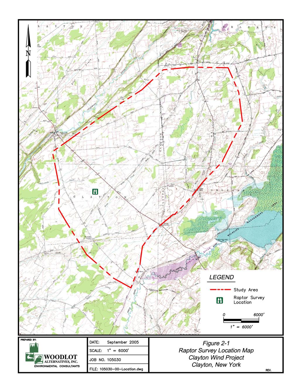
5 Proposed Clayton Wind Project Page ii List of Tables Table 3-1 Table 3-2 Table 4-1 Survey dates, level of effort, and weather Summary of regional spring migration studies using radar Summary of bat calls detected at Clayton, NY, during spring 2005 surveys List of Figures Figure 1-1 Study area location map Figure 2-1 Raptor survey location map Figure 2-2 Species composition of raptors observed during raptor surveys Figure 2-3 Hourly observation rates Figure 2-4 Raptor flight height distribution Figure 3-1 Radar location map Figure 3-2 Nightly passage rates observed Figure 3-3 Hourly passage rates for entire season Figure 3-4 Target flight direction Figure 3-5 Nightly mean flight direction Figure 3-6 Mean nightly flight height of targets Figure 3-7 Percent of targets observed flying below a height of 150 m (492 ) Figure 3-8 Hourly target flight height distribution Figure 4-1 Bat survey location map
6 Proposed Clayton Wind Project Page Introduction 1.1 Project Context PPM Atlantic Renewable has proposed the construction of a wind project to be located in Clayton, Orleans, and Brownville, New York (Figure 1-1). The project would include up to approximately megawatt (MW) wind turbines that could generate up to 150 MW of power annually. Turbines would have a maximum height of approximately 150 meters (m) (492 ) and would be located predominantly in active agricultural fields being used for hay and crop production, as well as for pasturing. Birds and bats are known to collide with tall structures during the migration season, such as buildings and communication towers, particularly when weather conditions are suboptimal for migration (Crawford 1981; Avery et al. 1976, 1977). Depending on their height and location, wind turbines can also pose a potential threat to migrating birds because they are relatively tall structures, have moving parts, and may be lit. The mortality of migrating and resident birds and bats has been documented at wind farms as a result of collisions with turbines, meteorological measurement towers (met towers), and guy wires (Anderson et al. 2004; Erickson et al. 2000, 2003; Johnson et al. 2003; Thelander and Rugge 2000). The surveys for this project were conducted to provide data that will be used to help assess the potential risk to birds and bats from this proposed project. The scope of the surveys was based on some standard methods that are developing within the wind power industry and consultation with the NY Department of Environmental Conservation (NYDEC). 1.2 Project Area Description The project area is located within the Eastern Ontario Plain ecozone of NY (Andrle and Carroll 1988). This is a relatively flat region, with elevation ranging from approximately 76 m to 152 m (250 to 500 ). Forest communities in the area are dominated by American elm (Ulmus americana), red maple (Acer rubrum), and northern hardwoods on soils of lake sediments that overlie limestone bedrock. Lake Ontario moderates the local climate, which has resulted in the widespread development of agricultural land uses, predominantly dairying.
7
8 Proposed Clayton Wind Project Page Survey Overview Woodlot Alternatives, Inc. (Woodlot) conducted field investigations for bird and bat migration during the spring of The overall goals of the investigations were to: document the occurrence and flight patterns of diurnally-migrating raptors (hawks, falcons, harriers, and eagles) in the project area, including number and species, general flight direction, and approximate flight height; document the overall passage rates for nocturnal migration in the vicinity of the project area, including the number of migrants, their flight direction, and their flight altitude; and document the presence of bats in the area, including the rate of occurrence and, when possible, species presence. The field surveys included day-time raptor migration surveys, a radar study of bird and bat migration activity, and recordings of bat echolocation calls in several landscape settings and heights. Surveys were conducted from April 15 to May 30, 2005, although effort for the different aspects of the work varied within this time period. A total of 10 days of raptor surveys, 36 nights of radar surveys, and 78 nights of bat detector recordings were completed. Raptor surveys were conducted near a meteorological met tower off of Lowe Road in Clayton. Methods employed were the same as those used by the Hawk Migration Association of North America (HMANA). Radar surveys were targeted for 45 nights from April 15 to May 30, Radar surveys were conducted from the vicinity of the same met tower as raptor surveys, which provided wind data for the time period of sampling. Radar data provide insight on the flight patterns of birds (and bats) migrating over the project area, including abundance, flight direction, and flight altitude. Bat surveys included the use of Anabat II (Titley Electronics Pty Ltd) bat detectors to record the location and timing of bat activity. One or 2 detectors were used during the survey, resulting in a total of 78 detector-nights that were recorded over the course of the 45 nights when the detectors were deployed. The detectors were deployed within the guy wire system of the met tower at heights of 15 m and 20 m (49 and 66 ) or, if one detector was used, at 20 m (66 ) above the ground. Deployment in this fashion provided information on the bat community in the project area. This report is divided into three primary sections that discuss the methods and results for each field survey. Each section includes summary graphs of the survey results. In addition, supporting data tables are provided in a separate appendix for each chapter.
9 Proposed Clayton Wind Project Page Diurnal Raptor Surveys 2.1 Introduction The Clayton project site is located in the northeast portion of the Central Continental Hawk Flyway. The Great Lakes, specifically Lake Ontario, play a central role in shaping migration dynamics near and in the project area. Rather than crossing these large water bodies, migrating hawks will typically circumvent them by traveling along the shoreline until they can again proceed in their desired direction. During northbound migration each spring, hawks generally bypass the Lakes by moving east along the southern lake shorelines they encounter, while typically moving west along the northern lake shorelines they encounter to circumvent the Lakes during southbound movements each fall. Given these observed trends, the eastern portion of the Central Flyway and specifically, the southern and eastern shores of Lakes Erie and Ontario, could be expected to concentrate large numbers of northbound raptors during spring migration. Woodlot conducted raptor surveys to determine if significant movement occurred in the vicinity of the proposed project location. The survey was conducted on 10 days spanning late March to early May, 2005, with the intent of documenting the dynamics of raptor migration in the project area, including species, abundance, approximate flight height, general direction and flight path, and other notable behaviors. 2.2 Methods Field Surveys Raptor surveys were conducted from a flat hayfield approximately 8 miles southeast of Clayton, NY. The survey site was adjacent to a 60 m (200 ) met tower located off of Lowe Road (Figure 2-1). This site, at an elevation of 122 m (400 ), is surrounded by flat agricultural fields interspersed with small woodland fragments and wetlands. It afforded unobstructed views in all directions, except for perhaps very lowflying birds beyond nearby low treelines. Raptor surveys occurred on 10 days from March 30 to May 7, 2005, and were generally conducted from 9 a.m. to 3 p.m. to include the time of day when the strongest thermal lift is produced and the majority of raptor migration occurs. Surveys were usually, but not always, conducted on days with favorable flight conditions produced by low-pressure systems bringing southerly winds and/or days following the passage of a weather front. Survey days were typically coordinated with strong migration flight forecasts made by the nearby Derby Hill Bird Observatory, which has been documenting spring raptor migrations for decades. Surveys were based on methods used by the HMANA. Observers scanned the surrounding airspace for raptors flying into the survey area and recorded detailed notes on each bird s location, flight path, approximate flight height, and behavior onto HMANA data sheets. Objects with known heights, such as the met towers and surrounding trees, were used to estimate flight height. Additionally, on some occasions, the nearby radar was used to verify estimated flight heights. Flight heights were categorized as less than or greater than 150 m (492 ) above the ground, which is the maximum height of the proposed wind turbine blades.
10
11 Proposed Clayton Wind Project Page 6 Information regarding an individual s behavior; such as known breeding range and habitat preferences, mating and breeding displays, and specific location within the project site; was incorporated to differentiate between migrant and resident birds. For most observations, flight paths of individuals were plotted on topographic maps of the project area. Hourly weather observations, including wind speed and direction, temperature, percent cloud cover, and precipitation, were recorded on HMANA data sheets. Birds that flew too rapidly or were too distant to accurately identify were recorded to their genus or, if identification to genus was impossible, as unidentified raptor. Data Analysis Field observations were summarized for each survey day and for the entire survey period. This included totaling the number of individuals for each species, height class (above or below 150 m), and hour of observation. In addition, the observation rate (birds per hour) was calculated and the overall abundance and identity of resident birds was estimated. Finally, the mapped flight paths of individuals were reviewed to identify if any patterns in migration activity over the project area occurred. Observations from the project area were compared to data obtained from local or regional HMANA hawk watch sites available from The HMANA watch site used for direct comparisons with the project site included Derby Hill in Mexico, NY; Braddock Bay in Greece, NY; and Hamburg, NY. The former two sites are located on the southern shoreline of Lake Ontario and the latter is located at the eastern end of Lake Erie. 2.3 Results A majority of the 10 surveys were conducted on clear days with light or moderate southerly winds. Throughout the survey period, most observations were made under clear skies, while three days experienced partly or mostly cloudy conditions. However, cloud cover did not seem to influence migratory movements as much as passing weather fronts. In fact, the largest count (N=271 birds), made on April 28, followed the passing of overnight rain and early morning drizzle. In general, visibility on most survey days was excellent and only twice was limited because of heavy cloud cover. Further, four surveys were conducted on days with light to moderate north or northeasterly winds, which is suboptimal for northbound raptor migration but did not appear to greatly affect overall totals. On these days, which account for 40 percent of all survey days, nearly one-third of the season s birds were observed. Surveys were conducted for a total of 58 hours during the 10 survey days. A total of 700 raptors, representing 14 1 species, were observed during that time, yielding an observation rate of 12.1 birds/hour (Appendix A Table 1; Figure 2-2). Broad-winged hawks (Buteo platypterus) N=252) and turkey vultures (Cathartes aura) (N=260) were the most commonly observed species and together accounted for 73.1 percent of the season s total birds. In decreasing order of abundance were red-tailed hawks (Buteo jamaicensis) (N=73; 10.4% of total), sharp-shinned hawks (Accipiter striatus) (N=25; 3.6% of total), and northern harrier (Circus cyaneus) (N=14; 2.0% of total). The remainder of observed species each comprised less than 1.5 percent of the total (each with 10 individuals) and include osprey (Pandion haliaetus), American kestrel (Falco sparverius), rough-legged hawk (Buteo lagopus), red-shouldered hawk (Buteo lineatus), Merlin (Falco columbarius), peregrine 1 Additional individuals that were not definitively identified were observed during the survey. While these were likely of the same species documented during the surveys, they have not been used in the calculation of the total number of species observed.
12 Proposed Clayton Wind Project Page 7 falcon (Falco peregrinus), bald eagle (Haliaeetus leucocephalus), golden eagle (Aquila chrysaetos), and Cooper s hawk (Accipiter cooperii). Some individuals remained unidentified (N=44) attributable to long distances or very brief looks. These were mostly from the genus Buteo (N=26), although several unidentified Accipiter (N=4) individuals were also observed. Of the aforementioned species, the golden eagle and peregrine falcon are listed as Endangered in NY, while the northern harrier and bald eagle are listed as Threatened. Species listed by the State as Species of Special Concern include osprey, redshouldered hawk, sharp-shinned hawk, and Cooper s hawk. Only one federally listed species was observed: the bald eagle, which is listed as Threatened. # of birds observed Clayton Raptor Survey Species Composition - Spring American Kestral Bald Eagle Broad-winged hawk Coopers Hawk Golden Eagle Merlin Northern Harrier Osprey Peregrine Falcon Red Shouldered Hawk Red Tailed Hawk Rough Legged Hawk Sharp-shinned Hawk Turkey Vulture Unid. Accipter Unid. Buteo Unid. Raptor Figure 2-2. Species composition of raptors observed during raptor surveys. Some observations of sharp-shinned hawks, American kestrels, and northern harriers were determined to be repeated sightings of the same individuals. In these cases, a particular bird may have been observed flying back and forth across the site or perching in an area repeatedly throughout one day or on multiple days. However, the vast majority of observed raptors were believed to be actively migrating and all observations are included in the count data reported. In general, those species with the highest seasonal totals ( 10 birds) were consistently observed throughout the season. An exception to this was the broadwinged hawk; of the 252 individuals observed, 242 (96%) were seen over a consecutive 2-day period in late April. In addition to some seasonal variation, the timing of raptor movement varied within each survey day. Typically, relatively few birds were observed during the first and last 2 hours of each day. The majority of birds (60.1%) were seen at mid-day from 11:00 a.m. to 1:00 p.m. (Figure 2-3) and this pattern remained consistent for all frequently observed species.
13 Proposed Clayton Wind Project Page 8 Clayton Raptor Survey Hourly Observations - Spring # of Birds :00-8:00 8:00-9:00 9:00-10:00 10:00-11:00 11:00-12:00 12:00-1:00 1:00-2:00 2:00-3:00 3:00-4:00 Figure 2-3. Hourly observation rates Flight heights were categorized as below or above 150 m (492 ), or the approximate maximum height of the proposed turbine blades. Overall, 61 percent of the observed raptors were estimated to be flying lower than 150 m. Differences in flight altitudes between species were also observed (Figure 2-4; Appendix A Table 3). Some species assemblages, such as the accipiters, vultures, and falcons, were consistently observed flying lower than 150 m (492 ). In fact, all of the falcons observed were flying below this height. Exceptions to this low-flying trend included broad-winged and red-tailed hawks, of which 58 percent and 41 percent, respectively, were flying less than 150 m above the ground. Overall, no species flew predominately above the 150 m threshold, while several species concentrated below 150 m. We acknowledge that issues of detectability may influence the counts of high-flying raptors.
14 Proposed Clayton Wind Project Page 9 Clayton Raptor Survey Flight Height Distribution - Spring 2005 # of Birds American Kestral Bald Eagle Broad-winged hawk 2.4 Discussion Coopers Hawk Golden Eagle Merlin Northern Harrier Osprey Peregrine Falcon Red Shouldered Hawk Red Tailed Hawk Rough Legged Hawk Sharp-shinned Hawk Figure 2-4. Raptor flight height distribution Turkey Vulture Unid. Buteo Unid. Raptor Unid. Accipter > 150 m < 150 m Raptor migration is a dynamic process responsive to both biotic and abiotic factors, migratory fitness, post-breeding dispersal, individual preferences, weather, and local and regional landscape characteristics. Migration varies by species both temporally and spatially, such that raptors are on the move almost every month of the year in some part of North America. In western NY, raptors moving north each spring become concentrated along the southern and eastern shores of Lake Erie and Lake Ontario because raptors generally prefer to not cross large bodies of water. In fact, raptor migration is so concentrated along these shores that popular hawk-watching sites have been established in Mexico (Derby Hill) and Hilton (Braddock Bay), NY; both along the southeastern shoreline of Lake Ontario. Hawk counts at these sites documented over 23,000 and 30,000 raptors, respectively, in spring Many of these raptors are presumed to continue flying along the eastern shoreline as they continue their annual migration northward. The Clayton project site is located along this flyway, slightly inland from the northeastern shore of Lake Ontario. Regional location can affect the intensity of raptor migration at a particular site. Two well-known examples include the coastal observatory at Cape May, New Jersey, and a ridgeline site at Hawk Mountain, Pennsylvania. The location of these sites relative to large, landscape-scale features (coasts, mountain ridges) results in large concentrations of migrating raptors. This likely happens at smaller scales as well, as river valleys and smaller ridgelines may result in more suitable migration conditions (i.e., strong thermal development, crosswinds, and updrafts) with the effect of concentrating raptors along organized pathways. Established hawk survey locations target these areas of known, concentrated raptor migration activity.
15 Proposed Clayton Wind Project Page 10 At the Clayton project site, the absence of proximate landscape-scale features such as river corridors or mountain ridges played a significant role in the migratory patterns through the project area. This lack of major topography served to distribute migrants fairly evenly across the project area, rather than in a concentrated flight corridor. Also, because of the lack of features to concentrate migrating raptors, relatively few were observed at Clayton than at other lake-side sites. More than 20,000 migrating raptors were observed at each of the two Lake Ontario hawk watch locations (Braddock Bay and Derby Hill). At the Lake Erie site in Hamburg, NY, more than 13,000 raptors were observed. By comparison, only 700 raptors were observed at Clayton. To correct for sampling effort (those sites included counts during nearly every day of the migration period) the passage rate, birds/observation hour, can be observed. The overall passage rate over Clayton was 12.1 birds/hour. Passage rates at Braddock Bay and Derby Hill were 68.8 birds/hour and 61.1 birds/hour, respectively, and the passage rate in Hamburg, NY was 33.2 birds/hour (Appendix A Table 4). The temporal and spatial flight dynamics of migrating raptors in the project area were variable and were often affected by temperature and wind patterns. Flight paths varied between survey dates and were most influenced by wind direction and speed. The lack of landscape-scale features suitable for creating updrafts meant that most migration movement occurred either via powered flight or after the ground had sufficiently heated to produce thermals (i.e., after 11:00 a.m. on most days). The most abundant species had a protracted migration pattern spanning most survey days, except for broad-winged hawks, the majority of which migrated through the area in a relatively brief, intense push in late April. Temperatures influenced the daily timing of flights, with the effect of delaying early morning flights and concentrating observations at mid-day. Both wind direction and speed affected specific flight paths and directional trends on any given day were usually dependent on prevailing winds but still always oriented northward. Separating migrants from resident birds was fairly straightforward at this site, given that migratory individuals nearly always flew higher, more purposeful routes in a general northward direction and birds suspected as residents were repeatedly observed flying at lower elevations, hunting, courting, or perching. The majority of raptors (61%) flew below the 150 m (492 ) height of the proposed turbine blades. Birds flying below this height should be considered more at risk of possible collision with the turbines, than those flying above the turbine blade height. Generally, it s still largely unknown what avoidance behavior migrating raptors possess when flying near wind turbines. Unpublished observations of hawk migration activity at an existing facility in New England (Woodlot, unpublished data) often included the passage of small raptors (such as sharp-shinned hawks) below the blade-swept area of turbines and the passage of larger raptors well above the turbines. Some observations have also included birds rising above one turbine and then decreasing altitude between turbines. It is unclear, however, if this type of presumed avoidance behavior would be observed at other wind turbine facilities in the East. 2.5 Conclusions Spring raptor migration surveys indicated that large numbers of raptors utilize the airspace directly over and surrounding the project site. However, passage rates were low at the Clayton site compared to observations from the Derby Hill observatory and other regionally well-known hawk migration survey sites. Observation rates (birds observed per hour of observation) were three to five times lower than these other sites, indicating that the project area may not represent a concentration area for migrating raptors.
16 Proposed Clayton Wind Project Page 11 Resident birds comprised only a small fraction of the total raptors observed but always flew at relatively low elevations while traveling around the project area. As such, residents were observed flying almost exclusively below the maximum height of the proposed turbines and usually below the blade-swept area. One of these more commonly observed resident species was the northern harrier, which is currently listed as Threatened in NY. Repeated observations of hunting and courtship activities indicate that this species is nesting in the project area. Another species listed by the State as a Species of Special Concern, the sharp-shinned hawk, is suspected to be nesting within the project area. Observations of this species included one to two individuals undertaking low flights while carrying food, indicative of nesting and chick-rearing activity. Other species listed as rare in the State or regionally were also observed. However, the individuals of those species were suspected to only be migrating through the project area and not nesting within it.
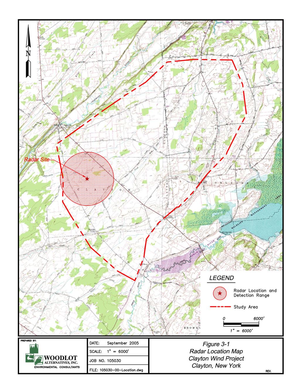
17 Proposed Clayton Wind Project Page Nocturnal Radar Survey 3.1 Introduction The vast majority of North American landbirds migrate at night. The strategy to migrate at night may be to take advantage of more stable atmospheric conditions for flapping flight (Kerlinger 1995). Conversely, species using soaring flight, such as raptors, migrate during the day to take advantage of warm rising air in thermals and laminar flow of air over the landscape, which can create updrafts along hillsides and ridgelines. Additionally, night migration may provide a more efficient medium to regulate body temperature during active, flapping flight and could reduce the potential for predation while in flight (Alerstam 1990, Kerlinger 1995). Collision with unseen obstacles is a potential hazard to night-migrating birds. Additionally, some lighted structures may actually attract birds to them under certain weather conditions, which can be associated with collision or exhaustion of birds, both of which often result in mortality (Ogden 1996). For example, birds have been documented colliding with tall structures, such as buildings and communication towers, particularly when weather conditions are foggy (Crawford 1981; Avery et al. 1976, 1977). Wind turbines can also pose a potential threat to migrating birds as they are relatively tall structures, have moving parts, and may be lit, depending on their height and location (Erickson et al. 2000). Factors that could affect potential collision risk of nocturnally-migrating birds by wind turbines can include weather, magnitude of migration, height of flight, and movement patterns in the vicinity of a wind project, along with the height of turbines and other site-specific characteristics of a wind project. Radar surveys were conducted at the Clayton project area to characterize spring nocturnal migration patterns in the area. The goal of the surveys was to document the overall passage rates for nocturnal migration in the vicinity of the project area, including the number of migrants, their flight direction, and their flight altitude. 3.2 Methods Field Methods A single marine surveillance radar similar to that described by Cooper et al. (1991) was used to document the night-time movement of migrating birds and bats over the study area. The radar was located in a small field largely surrounded by low trees near the met tower off of Lowe Road in Clayton (Figure 3-1). The radar had a peak power output of 25 kw and the ability to track small animals, including birds, bats, and even insects out to distances of up to 1.2 kilometer (km) (3,937 ). The radar cannot, however, readily distinguish between different types of animals being detected. Consequently, all animals observed on the radar screen are called targets. The radar was equipped with a 2-m (6.5 ) waveguide antenna. The antenna has a vertical beam height of 20º (10º above and below horizontal) and the front end of it was inclined approximately 5º to increase the proportion of the beam directed into the sky. Objects on the ground detected by the radar cause returns on the radar screen (echoes) that appear as blotches called ground clutter. Large amounts of ground clutter reduce the ability of the radar to track birds and bats flying over those areas. By utilizing the tree lines around the radar location, ground clutter was reduced as much as possible. DRAFT
18 Proposed Clayton Wind Project Page 13 The radar was operated in two modes during each survey hour. In the first (surveillance) mode, the antenna spins horizontally to survey the airspace around the radar and detects targets moving through the area. By analyzing the echo trail, the number, flight direction, and speed of targets can be determined. In the second (vertical) mode of operation, the antenna is rotated 90º to vertically survey the airspace above the radar (Harmata et al. 1999). In vertical mode, target echoes do not provide directional data but do provide information on the altitude of targets passing through the vertical, 20º radar beam. The radar was operated at a range of 1.4 km (0.75 nautical miles). At this range, the echoes of small birds can be easily detected, observed, and tracked. At greater ranges, larger birds can be detected but the echoes of small birds are reduced in size and restricted to a smaller portion of the radar screen, reducing the ability to observe the movement pattern of individual targets. The geographical limits of the range setting used are depicted in Figure 3-1. Radar surveys were conducted from sunset to sunrise. Forty-five nights of sampling were targeted between April 15 and May 30, Because the anti-rain function of the radar must be turned down to detect small songbirds and bats, surveys could not be conducted during periods of inclement weather. Therefore, surveys were targeted largely for nights without rain. However, in order to characterize migration patterns during nights without optimal conditions, some nights with weather forecasts including occasional showers were sampled. In total, 36 nights of sampling were conducted over the 45 targeted nights due to poor performance of the radar because of weather. Data Collection The radar display was connected to video recording software of a computer. During surveillance mode, 15 one-minute samples of the radar display were recorded for each survey hour. During vertical mode, a single 10-minute video sample was recorded for each survey hour. The video samples were recorded on the following schedule for each 1-hour period after sunset: Seven 1-minute samples during the first 15 minutes after sunset; One 10-minute vertical sample during the next 30 minutes; and Eight 1-minute samples during the last 15 minutes of the hour. During the 30-minute period when vertical data were recorded, additional information was also recorded, including weather observations and ceilometer observations. Weather data that was recorded included wind speed and direction, cloud cover, temperature, and precipitation. Ceilometer observations involved directing a one million candlepower spotlight vertically into the sky in a manner similar to that described by Gauthreaux (1969). The ceilometer beam was observed by eye for 5 minutes to document and characterize low-flying (below 150 m) targets. The ceilometer was held in-hand so that any birds, bats, or insects passing through it could be tracked for several seconds, if needed. On nights with a full moon and clear skies, the ceilometer beam was too diffuse to readily detect birds and bats. On those nights, moonwatching (Lowery 1951) was used, which involved watching the face of the moon with binoculars for 5 minutes and recording any observations of birds or bats flying in front of the moon. Observations from each ceilometer or moonwatching period were recorded by hand, including the number of birds, bats and insects observed. This information was used during data analysis to help distinguish between insects from bird and bat targets.
19
20 Proposed Clayton Wind Project Page 15 Data Analysis The video samples were analyzed using a digital video analysis software tool developed by Woodlot. For horizontal samples, targets were identified as birds and bats rather than insects based on their speed. The speed of targets was compared with wind speed and direction; targets traveling faster than approximately 7 m per second were identified as a bird or bat target. The software tool recorded the time, location, and flight vector for each target traveling fast enough to be a bird or bat. The results for each sample were output to a spreadsheet. For vertical samples, the software tools recorded the entry point of targets passing through the vertical radar beam, the time, and flight altitude above the radar location. The results for each sample were output to a spreadsheet. These datasets were then used to calculate passage rate, flight direction, and flight altitude of targets. Hourly passage rates (in 1-hour increments post sunset) were calculated by tallying the total number of targets in the 1-minute samples for each hour and correcting for the number of samples collected in that hour. That estimate was then corrected for the radar range setting that was used in the field and was expressed as targets/km/hour (t/km/hr) ± 1 SE. The hourly rates were used to calculate passage rates for each night and the entire season. Mean target flight directions (± 1 circular SD) were summarized in a similar manner: by hour, night, and for the entire season. Flight direction analysis and statistical analyses were conducted using software designed specifically to analyze directional data (Oriana2 Kovach Computing Services). The statistics used for this are based on Batschelet (1965), which take into account the circular nature of the data. Nightly wind direction was also calculated using similar methods and data collected from the central met tower, near the radar site. Mean wind speed was calculated using linear statistics (Zar 1999). Flight altitude data were summarized using linear statistics. Mean flight altitudes (± 1 SE) were calculated by hour, night, and overall season. The percent of targets flying below 125 m (492 ), the approximate maximum height of proposed wind turbines, was also calculated hourly, for each night, and for the entire survey period. 3.3 Results Radar surveys were conducted during approximately 303 hours on 36 nights between April 15 and May 30, 2005 (Table 3-1). The radar site provided generally good visibility of the surrounding airspace and targets were observed in most areas of the radar display unit. Passage Rates A total of 2,778 one-minute radar video samples were analyzed during the passage rate and flight direction analysis and included a total of 53,134 targets. Nightly mean passage rates varied from 71 ± 14 t/km/hr (May 22) to 1,769 ± 87 t/km/hr (April 19), and the mean passage rate for the entire survey period was 460 ± 63 t/km/hr (Figure 3-2; Appendix B Table 1).
21 Proposed Clayton Wind Project Page 16 Table 3-1. Survey dates, level of effort, and weather Clayton, Spring 2005 Night of Sunset Sunrise Hours of Survey Weather Wind Direction (coming from) Apr 15 7:48 PM 6:18 AM 3 calm and clear Apr 16 7:50 PM 6:16 AM 7 calm and clear Apr 17 7:51 PM 6:15 AM 11 calm, cloudy then clear Apr 18 7:52 PM 6:13 AM 11 calm and clear Apr 19 7:53 PM 6:12 AM 3 not available Apr 21 7:56 PM 6:08 AM 11 calm and clear Apr 24 7:59 PM 6:04 AM 11 light breeze, partly cloudy SSE Apr 26 8:01 PM 6:01 AM 6 light breeze, partly cloudy SE Apr 27 8:03 PM 5:59 AM 9 calm and mostly clear SE Apr 28 8:04 PM 5:58 AM 8 breezy, partly cloudy SW Apr 29 8:05 PM 5:56 AM 10 cloudy, mostly calm, light showers early S May 1 8:07 PM 5:53 AM 10 calm, partly cloudy, hazy with some rain SSE May 2 8:09 PM 5:52 AM 10 light breeze, partly cloudy WSW May 4 8:11 PM 5:49 AM 6 calm and clear May 5 8:12 PM 5:48 AM 10 calm and clear E May 6 8:13 PM 5:47 AM 10 calm and clear SSE May 7 8:14 PM 5:46 AM 7 calm and clear NE May 8 8:16 PM 5:44 AM 10 calm, partly cloudy then clear ENE to NE May 9 light breeze, partly cloudy then calm and 8:17 PM 5:43 AM 8 clear NNE May 10 8:18 PM 5:42 AM 8 partly cloudy, light breeze, passing showers NW May 11 8:19 PM 5:41 AM 7 light breeze, cloudy SW May 12 8:20 PM 5:40 AM 10 calm and clear, cold May 15 8:24 PM 5:36 AM 6 light breeze, partly cloudy SW May 16 8:25 PM 5:35 AM 10 breezy, partly cloudy SW May 17 8:26 PM 5:34 AM 10 calm and cloudy SW May 18 8:27 PM 5:33 AM 10 calm and cloudy, cold May 19 8:28 PM 5:32 AM 10 light breeze, clear N May 20 8:29 PM 5:31 AM 8 calm and clear NE May 22 8:31 PM 5:30 AM 9 calm and cloudy, light rain NE May 23 light breeze, mostly cloudy, some rain 8:32 PM 5:29 AM 9 showers NE May 24 8:33 PM 5:28 AM 7 light breeze, partly cloudy NNE May 25 8:34 PM 5:27 AM 9 light breeze, clear NE May 27 8:36 PM 5:26 AM 7 calm and partly cloudy, rain late NE May 28 8:37 PM 5:25 AM 9 light breeze, cloudy NE May 29 8:38 PM 5:25 AM 8 calm and clear WSW May 30 8:38 PM 5:24 AM 5 calm and cloudy WSW Note: Additional nights of survey were attempted but foul weather prevented the initiation of surveys.
22 Proposed Clayton Wind Project Page 17 Targets/km/hr Clayton Nightly Passage Rates - Spring 2005 Apr 15 Apr 16 Apr 17 Apr 18 Apr 19 Apr 21 Apr 24 Apr 26 Apr 27 Apr 28 Apr 29 May 1 May 2 May 4 May 5 May 6 May 7 May 8 May 9 May 10 May 11 May 12 May 15 May 16 May 17 May 18 May 19 May 20 May 22 May 23 May 24 May 25 May 27 May 28 May 29 May 30 Night of Figure 3-2. Nightly passage rates (error bars = 1 SE) observed. Individual hourly passage rates throughout the entire season varied from 19 to 1,944 t/km/hr. Hourly passage rates varied throughout each night and for the season overall. In general, passage rates were highest during the third through sixth hours after sunset, followed by a relatively steady decline for the remainder of the night until a sudden rise in activity during the eleventh hour just before dawn (Figure 3-3). Clayton Hourly Passage Rate - Spring Targets/km/hr Hours after Sunset Figure 3-3. Hourly passage rates for entire season.
23 Proposed Clayton Wind Project Page 18 Flight Direction Mean flight direction over the radar was 30º ± 53º (Figure 3-4; Appendix B Table 2). There was considerable night to night variation in mean direction, although within each night there was less variation (Figure 3-5). The average nightly flight direction was typically north to northeast on more than three quarters of the nights sampled. Flight Altitude The mean flight height of all targets was 443 m ± 38 m (1,453 ± 125 ) above the radar site. The average nightly flight height ranged from 199 m ± 8 m (653 ± 26 ) to 753 ± 36 (2,470 ± 118 ) (Figure 3-6, Appendix B Table 3). The percent of targets observed flying below 150 m (492 ) also varied by night, from 2 percent to 42 percent (Figure 3-7). The seasonal average percentage of targets flying below 150 m was 14 percent.
24
25
26
27
28
29 Proposed Clayton Wind Project Page Clayton Mean Nightly Flight Height - Spring 2005 Mean flight Height = 442 m Max Turbine Height = 150 m Altitude (m) Night of Figure 3-6. Mean nightly flight height of targets Clayton Percent of Targets Below 150 m - Spring 2005 Percent of Targets 45% 40% 35% 30% 25% 20% 15% 10% 5% 0% Night of Figure 3-7. Percent of targets observed flying below a height of 150 m (492 )
30 Proposed Clayton Wind Project Page 25 Hourly flight height was generally consistent throughout the night, except during the first and eleventh hours after sunset when heights were lower (Figure 3-8). This is presumably the time during which migrants are ascending to or descending from their nightly flight height. Clayton Hourly Flight Height - Spring Mean Flight Height (m) Hours after Sunset Figure 3-8. Hourly target flight height distribution Ceilometer Observations Ceilometer data collected during the radar survey yielded a total of 265 observations. Those observations, however, resulted in relatively few bird observations and relatively light insect activity. Eight birds were observed flying through the ceilometer beam. 3.4 Discussion Spring 2005 radar surveys documented migration activity and patterns in the vicinity of the proposed Clayton wind project area. In general, migration activity and flight patterns varied between and within nights. Nightly variation in the magnitude and flight characteristics of nocturnally-migrating songbirds is not uncommon and is often attributed to weather patterns, such as cold fronts and winds aloft (Hassler et al. 1963, Gauthreaux and Able 1970, Gauthreaux 1971, Richardson 1972, Able 1973, Bingman et al. 1982, and Gauthreaux 1991). Passage Rates As indicated above, weather patterns are probably the largest factor affecting the magnitude of bird migration, particularly at inland sites. In the spring, an approaching low pressure system typically produces light southerly winds from the west or southwest. Bird migration is often more abundant during these periods because of favorable wind direction for spring migration until the system passes (Richardson 1972). Consequently, nightly migration traffic rates can be expected to be variable and to
31 Proposed Clayton Wind Project Page 26 peak when the best migration weather occurs. The variable nightly passage rates documented at Clayton are consistent with this. Passage rates were variable on cloudy nights and generally low on nights with fog and passing showers, indicative of the role that weather can play in bird migration activity. Nightly passage rates varied from 71 ± 14 to 1,769 ± 87 t/km/hr, with an overall mean of 450 ± 62 t/km/hr. Passage rates often peaked 3 to 6 hours after sunset, which is typical of nighttime migration activity (Able 1970; Gauthreaux 1971; Richardson 1971, 1972). However, average hourly flight heights for the entire season were consistent between 2 and 10 hours after sunset. Few surveys using the same methods and equipment and conducted during the same time period are available for comparison (Table 3-2). In a similar study overlooking Lake Erie in western NY, Cooper et al. (2004a) documented spring 2003 passage rates between 15 and 1,702 t/km/hr with an overall passage rate of 395 t/km/hr. Previous studies by the same researchers found lower passage rates both in this general area of NY (Wethersfield) as well as in an upstate area (Carthage). Table 3-2 Summary of regional spring migration studies using radar (Cooper et al. 2004a). Location Passage Rate Chautauqua, NY 395 Carthage, NY 159 Wethersfield, NY 41 There are limitations in comparing that data with data from 2005, as year-to-year variation in continental bird populations invariably affects how many birds migrate through an area. However, nightly mean passage rates observed at Clayton were within the range of those studies. Flight Direction Some research suggests that bird migration may be affected by landscape features, such as coastlines, large river valleys, and mountain ranges. This has been documented for diurnally-migrating birds, such as raptors, but is not as well established for nocturnally migrating birds (Sielman et al. 1981; Bingman et al. 1982; Bruderer and Jenni 1990; Richardson 1998; Fortin et al. 1999; Williams et al. 2001; Diehl et al. 2003; Woodlot Alternatives, Inc. unpublished data). Evidence suggesting topographic effects to night-migrating birds has typically included areas of varied topography, such as the Alps and most rugged areas of the northern Appalachians. The landscape around the Clayton project area is very flat, with low hills. This is considerably less than in those other areas where potential topographic effects on flight direction have been observed. The mean flight direction was 30º ± 53º and there are no indications that the topography is altering the movement of migrants through the area. Flight Height The altitude at which nocturnal migrants fly has been one of the least understood aspects of bird migration. Bellrose (1971) flew a small plane at night along altitudinal transects to visually document the occurrence and altitude of migrating songbirds. He found the majority of birds observed were between 150 m and 450 m (492 to 1,476 ) above the ground level, but on some nights the majority of birds observed were from 450 m to 762 m (1,476 to 2,500 ) above the ground. Radar studies have largely confirmed those visual observations, with the majority of nocturnal bird migration appearing to occur less
32 Proposed Clayton Wind Project Page 27 than 500 m to 700 m (1,640 to 2,297 ) above the ground (Able 1970, Alerstam 1990, Gauthreaux 1991, Cooper and Ritchie 1995). Recent studies at other proposed wind facilities in the Northeast and Mid-Atlantic states are consistent with this as well. Cooper et al. (2004a) documented a mean overall flight altitude of 528 m ± 3 m during a spring migration survey in Chautauqua, NY. The highest percentage (36%) of migrants was documented 300 m to 600 m above the ground and the smallest percentage (0.1%) above 1,401 m. In western NY, Cooper et al. (2004a) documented a mean flight altitude of 532 m with a small percentage (4%) of targets flying less 125 m above the ground. Results from Clayton are similar to those of Cooper et al. (2004a,b), with nightly flight altitudes varying from 199 m ± 8 m to 753 m ± 118 m and a mean of 443 m ± 38 m. The percentage of targets flying less than 150 m above the ground was low (14%), also similar to that found by Cooper et al. (2004a). 3.5 Conclusions Radar surveys during the spring 2005 migration period have provided important information on nocturnal bird migration patterns in the vicinity of the Clayton project area. The results of the surveys indicate that bird migration patterns are generally similar to patterns observed at other sites in the region. Migration activity varied throughout the season, which is probably largely attributable to weather patterns. The mean passage rate (460 ± 63 t/km/hr) is higher than that observed at similar studies, although the range in nightly passage rate (71 ± 14 to 1,769 ± 87 t/km/hr) is similar to those other studies during the previous fall. Migration activity throughout each night typically peaked 5 hours after sunset with a sudden rise in activity just before dawn. Flight direction for the entire season was 19 ± 83. Flight direction data indicate that nocturnal migrants are not avoiding the project area for any topographic-related reasons. The average flight altitude above the ground was 443 m ± 38 m. Only 14 percent of the targets observed during vertical radar operation were flying below an altitude of 150 m (492 ), the height of the proposed turbines, indicating that risk of collision to night-migrating birds is limited to a very small subset of those birds. Risk to nocturnally-migrating birds is known to occur, particularly during periods of inclement weather that can force birds to fly at lower heights and decrease night-time visibility. No consistent trend between flight height and weather patterns was observed. However, nights with inclement weather, which could be associated with increased risk, typically had low passage rates. While increased risk potential could develop due to inclement weather, the prediction of those events cannot be reliably made because night to night variation in flight characteristics occur, even on nights with similarly unsuitable migration weather.
33 Proposed Clayton Wind Project Page Bat Survey 4.1 Introduction Wind projects have been cited as a potential threat to migrating bats for a number of years, especially since a study at the Mountaineer Wind Energy Facility in Tucker County, West Virginia, documented 475 dead bats between April 20 and November 9, 2003 (Johnson and Strickland 2004). Subsequent fieldwork in 2004 at the Mountaineer site and nearby Meyersdale Wind Facility has revealed even higher rates of bat collision mortality with operating wind turbines (Arnett et al. 2005). These studies have raised numerous concerns regarding the potential for collision mortality associated with wind turbines to impact bat populations (Williams 2003). The concerns lie primarily with wind farms in the eastern United States, where documented bat fatality rates have been considerably higher (bats per turbine per year) than at western wind farms (Williams 2003, Arnett et al. 2005). Researchers currently have limited understanding of the specific factors influencing rates of bat collision mortality, although evidence from the timing of fatalities documented at existing wind facilities and other structures suggests that migrating bats are at the highest risk (Johnson and Strickland 2004, Johnson et al. 2003, Whitaker and Hamilton 1998). A number of plausible hypotheses explaining the high rates of bat mortality have been presented by bat researchers, but none of these have been adequately tested. The most likely mechanisms explaining bat collision center on the possibility that ridges act as corridors for migrating or feeding bats, that bats are unable to detect turbines visually or by echolocation, or that bats may be attracted to wind turbines due to artificially high insect concentrations, light attraction, or acoustic attraction (Arnett et al. 2005). Nine species of bats occur in NY, based upon their normal geographic range. These are the little brown myotis (Myotis lucifugus), northern myotis, (Myotis septentrionalis), Indiana myotis (Myotis sodalis), Eastern small-footed myotis (Myotis leibii), silver-haired bat (Lasionycteris noctivagans), Eastern pipistrelle (Pipistrellus subflavus), big brown bat (Eptesicus fuscus), Eastern red bat (Lasiurus borealis), and hoary bat (Lasiurus cinereus) (Whitaker and Hamilton 1998). Of these, the Indiana myotis is listed as federally endangered, and the small-footed bat is listed as a special concern species by the State. According to the NYDEC, eight Indiana myotis hibernacula are present in NY, located in Albany, Essex, Jefferson, Onondaga, Ulster, and Warren counties (NYDEC website, accessed 8/4/05). Clayton is located near the center of Jefferson County, in north central NY. Due to the proximity of the Clayton site to known Indiana myotis hibernacula, it is highly likely that the species is present in the study area. This was confirmed by the NYDEC in the spring of 2005 during a radio telemetry study (pers. comm. Al Hicks, NYDEC). To document bat occurrence in the area of the proposed wind project, Woodlot conducted acoustic monitoring surveys from April 20 to May 30, Visual ceilometer observations were also made between April 15 and May 30, 2005, concurrent with a nocturnal radar study. Acoustic surveys were the primary survey type used in this study, and were designed to document bat passage rates in different habitat types and from ground level to heights of 20 m (66 ). A primary goal of these surveys was to attempt to document the presence of bats migrating and foraging in and near the rotor zone of the proposed wind project. The majority of bats found in the eastern United States migrate, gather together near hibernacula, or enter hibernation between late July and early November (Whitaker and Hamilton 1998). Because recent research indicates that migrating bats appear to have a higher risk of collision with wind turbines than birds, most mortality at a wind farm would be
34 Proposed Clayton Wind Project Page 29 expected to occur during the fall and spring bat migrations, the timing of which depends upon the bat species and the location. 4.2 Methods Field Surveys Anabat II detectors were used for the duration of this study. Anabat detectors are frequency-division detectors, dividing the frequency of ultrasonic calls made by bats (a factor of 16 was used in this study 2 ) so that they are audible to humans. These detectors are able to detect all bat species known to occur in New England using this setting. Data from the Anabat detectors were logged onto compact flash media using a CF ZCAIM (Titley Electronics Pty Ltd) and downloaded to a computer for analysis. The acoustic surveys were designed primarily to document the occurrence and detection rates of bats near the ground and at heights near the low end of the blade-swept area of the proposed turbines. To do this, one to two detectors were suspended from the guy wires of the met tower near Lowe Road in Clayton (Figure 4-1). The two detectors were suspended at heights of 15 m and 20 m (49 and 66 ) from the met tower guy wires. Detectors were programmed to record data from 7:00 p.m. to 7:00 a.m. nightly, resulting in 12 hours of sampling per detector per night. 2 The frequency division setting literally divides ultrasonic calls detected by the detector by the division setting in order to produce signals at frequencies audible to the human ear.
35
36 Proposed Clayton Wind Project Page 31 Data Analysis Call files were extracted from data files using CFCread software, with default settings in place. Nightly tallies of detected calls were compiled for each detector. Mean detection rates (calls/hour and calls/night) were calculated for each night. These were summarized by time period within the migration season and detector location (15 m or 20 m high in the met tower). Detection rates indicate only the number of calls detected, and do not necessarily reflect the number of individual bats in an area. Ultrasonic calls of bats are attenuated quickly by the atmosphere, and are only able to travel limited distances, depending upon their frequency (Griffin 1970, 1971). Also, Anabat detectors have a limited range of roughly 10 m to 15 m (33 to 49 ). This was confirmed at the beginning of the survey period using an artificial bat chirp device and field tests with flying bats. Consequently, the height of bat calls recorded by the detectors deployed in the met tower was assumed to be roughly that of the detector that recorded the bat. In addition to documenting passage rates, acoustic surveys with Anabat II detectors allow for limited species identification (O Farrell and Gannon 1999). Because bat calls vary widely within species, and are influenced by habitat and region, definitive species identification based upon acoustic monitoring alone is not always possible. However, several of the species that are present in this area have calls that appear distinct when recorded with the Anabat system. Qualitative visual comparison of recorded call sequences of sufficient length to reference libraries of bat calls allows for relatively accurate identification of bat species (O Farrell et al. 1999a). Calls recorded during the survey were compared to reference calls compiled by Chris Corben, the designer of the Anabat II software used in this study, and data from the University of Maine Mammalogy Department. These reference calls were of western and northeastern origin and served as a basis for differentiating the calls that were recorded. Recorded calls were classified based upon the shape of the call sequence, the slope, and the maximum and minimum frequencies. Calls with insufficient material upon which to determine the species were classified as unknown. Because calls within the Myotis genus are so similar, they were not identified to the species level. Ceilometer Surveys As noted in Section 3.2, ceilometer surveys took place for 5 minutes during each hour of radar sampling. While species identification was not possible, targets were classified as either bats or birds and helped provide insight into the composition of the migrant animal population that occurred at low altitudes. The ceilometers were held in-hand so that animals passing through the light beam were followed for several seconds. 4.3 Results Acoustic Monitoring During the sampling period, a total of 67 bat call sequences were detected and recorded (Table 4-1). Of the total bat passages detected while high and low bat detectors were operating simultaneously, 55 (83%) were detected by the high bat detector, operating at a height of roughly 20 m (66 ). This results in detection rates of 1.6 calls/night of survey and 0.9 calls/detector-night. Bats were detected between May 5 and May 28, with the peak passage rates occurring on May 6, when 15 call sequences were detected.
37 Proposed Clayton Wind Project Page 32 Table 4-1. Summary of bat calls detected at Clayton, NY, during spring 2005 surveys. Species High Low Total Big brown Bat Hoary Bat Silver-haired Bat Myotis sp Unknown Entire Season Recorded calls were classified by species based upon the shape of the call sequence, the slope, and the maximum and minimum frequencies. Visual comparisons were made to libraries of known reference calls. Of the 67 recorded calls, 27 were identified as big brown bats, 18 as silver-haired bats, 12 as Myotis sp., and one as a hoary bat. Nine calls were classified as unknown, due to insufficient material on which to base an identification. Because calls within the genus Myotis are so similar, we did not attempt to differentiate between species. Ceilometer Data Ceilometer data collected during the radar survey yielded a total of 265 observations. Those observations, as is typical, resulted in no bat observations. 4.4 Discussion Bat mortality at wind projects in the eastern United States has recently been identified as a potential risk to certain bat populations (Williams 2003). The study of this issue, however, poses difficulties, including insufficient scientific understanding of bat migration patterns and navigation systems, inadequate amounts of data on mortality rates and interactions between bats and turbines at existing wind farms in forested landscapes, a lack of accurate population estimates for many bat species, and limited monitoring methods available that provide credible, comprehensive, and reliable data on bat movements. This study aimed to document passage rates of bats in and near the blade-swept zone of the proposed wind farm. Spring sampling at Clayton revealed very low levels of bat activity in late April, and moderate levels of bat activity during the month of May. Bats were recorded 21 of the 42 nights sampled. The majority (72%) of call sequences was detected during the first 4 hours of the night (between 8:00 p.m. and midnight). Detection rates were 1.6 calls/night for the 42 nights, but were 0.9 calls/detectornight when corrected for the number of detectors deployed and operating. Of the 67 recorded calls, the majority were identified as big brown bat (27), silver-haired bat (18), and Myotis sp. (12). We did not attempt to differentiate between species within the genus Myotis, which includes the federally endangered Indiana myotis. However, most of the Myotis calls that were detected at Clayton were between 40 and 60 khz, which is somewhat lower than the frequency of Indiana myotis calls, and most closely resembled the call shape of little brown bats. Clayton is located in Jefferson County, which is one of six counties in NY known to contain at least one Indiana myotis hibernacula. The nearest of which is located near Brownville, 16 to 32 km (10 to 20 miles) south of Clayton.
38 Proposed Clayton Wind Project Page 33 The ability to identify bats by acoustic methods requires significant amounts of practice and the accuracy of this method has been debated (O Farrell et al. 1999b). The quality and length of recorded calls also influences the degree to which identification is possible (O Farrell and Gannon 1999). The species identifications presented in this report are based on call analysis alone, and therefore are subject to error. The greatest potential for false identification would be in differentiating between big brown and silverhaired bats, due to the similarity of their call structure. Data from spring bat surveys at Clayton revealed higher levels of bat activity at 20 m (66 ) than at 15 m (49 ). Eighty-three percent of bat passages were detected by the high detector. The high and low detectors both functioned properly throughout the survey period, and were configured in exactly the same manner, although slight differences in sensitivity may have existed between the two detectors. Species detected by the high and low detectors were similar, although no silver-haired bats were detected by the low detector. Emerging information on the potential susceptibility of bats to wind turbine-induced mortality indicates that some species may be particularly vulnerable to collisions with turbines. The tree roosting bats, (hoary and eastern red bats), along with the silver-haired bat, appear to have a higher risk of collision with wind turbines, based on mortality data collected at existing facilities. Although these species are all relatively common, they have constituted disproportionably large percentages of bat fatalities at existing facilities. Ultrasonic calls of bats are attenuated quickly by the atmosphere and are only able to travel limited distances, depending upon their frequency (Griffin 1970, 1971). Anabat detectors have a limited range, roughly 10 m to 15 m (33 to 49 ), based upon trials with an artificial bat chirp and field tests with flying bats. Due to these factors, a single Anabat II detector samples a cone of airspace approximately 45º wide and 9 m to 15 m (30 to 49 ) deep. Therefore, the detection distance of the upper detector, at 30 m (98 ), would extend only 3 m to 5 m (10 to 16 ) into the bottom of a wind turbine s blade-swept area, representing only roughly 1 to 3 percent of that area. Detectors were unable to sample bat passage rates in the central and upper regions of the rotor zone, which are at heights of approximately 80m (262 ) and 110 m (361 ). It is not known whether or not certain bat species migrate at these higher altitudes. Because our detectors sampled only to roughly 20 m (66 ), our methods would not have detected bats that may have been flying at higher altitudes. Additionally, our methods only allow the detection of bats that are producing ultrasonic signals. One possible explanation for why migrating bats may collide with turbines is that they do not use their echolocation system while migrating. This would either mean that bats do not monitor reflected echolocation signals, or that they do not produce ultrasonic signals when migrating, in which case they would be invisible to acoustic bat detectors. This possibility must be taken into account when interpreting data from acoustic monitoring surveys. 4.5 Conclusions Acoustic bat surveys revealed very relatively low numbers of bats in the Clayton site during spring Bats were detected between April 24 and May 28, although the greatest number of bats detected in one night was two bats on the night of May 6. More bat passages were detected at the high detector than at the low detector at the Clayton site. No definitive determination of the presence or absence of any rare bats from the project area can be made. Although 12 calls were identified as belonging to the genus Myotis, these calls could not be positively
39 Proposed Clayton Wind Project Page 34 identified to species. The Clayton site is known to be used by Indiana bats and calls recorded during the spring survey could be those of this species. The many factors that may influence bat collision rates with wind turbines are largely unknown, it is impossible to accurately predict whether or not a wind facility will cause significant bat mortality before it is operational. Many of the theories explaining bat collisions, such as acoustic attraction and insect concentration, suggest that the operation of the turbines may actually attract bats. Because acoustic monitoring surveys detect only those bats that are producing ultrasonic signals, and because this survey technique samples a very small air space relative to the rotor zone of a single wind turbine, let alone an entire wind facility, results from these surveys must be interpreted with caution. Acoustic sampling reveals activity patterns, species distributions, and can document bats presence in the air space near the rotor zone of wind turbines, but cannot monitor the entire rotor zone of a turbine, and cannot predict how bats might interact with an operational turbine.
40 Proposed Clayton Wind Project Page Literature Cited Able, K.P A radar study of the altitude of nocturnal passerine migration. Bird-Banding 41(4): Able, K.P The role of weather variables and flight direction in determining the magnitude of nocturnal migration. Ecology 54(5): Alerstam, T Bird Migration. Cambridge University Press, Cambridge, United Kingdom. 420 pp. Anderson, R., N. Neumann, J. Tom, W.P. Erickson, M.D. Strickland, M. Bourassa, K.J. Bay, and K.J. Sernka Avian monitoring and risk assessment at the Tehachapi Pass Wind Resource Area. Technical Report prepared by State of CA and WEST Inc. for NREL. 102 pp. Andrle, R.F. and J.R. Carroll The atlas of breeding birds in New York State. Cornell University Press, Ithaca and London. 551 pp. Arnett, Edward, B., W.P. Erickson, J. Kerns, and J. Horn Relationships between bats and wind turbines in Pennsylvania and West Virginia: an assessment of fatality search protocols, patterns of fatality, and behavioral interactions with wind turbines. Bats and Wind Energy Cooperative. 168 pp. Avery, M.L., P.F. Spring, and J.F. Cassel The effects of a tall tower on nocturnal bird migration a portable ceilometer study. Auk. 93(2): Avery, M.L., P.F. Spring, and J.F. Cassel Weather influences on nocturnal bird mortality at a North Dakota tower. Wilson Bulletin. 89(2): Batschelet, E Statistical methods for the analysis of problems in animal orientation and certain biological rhythms. AIBS Monograph. American Institute of Biological Sciences. Washington, DC. 57 pp. Bellrose, F.C The distribution of nocturnal migration in the air space. The Auk 88: Bingman, V.P., K.P. Able, and P. Kerlinger Wind drift, compensation, and the use of landmarks by nocturnal bird migrants. Animal Behavior 30: Bruderer, B., and L. Jenni Migration across the Alps. Pages in Bird Migration: Physiology and Ecophysiology (E. Gwinner, Ed.). Springer Verlag, Berlin. Cooper, B.A., and R.J. Ritchie The altitude of bird migration in east-central Alaska: a radar and visual study. Journal of Field Ornithology 66(4): Cooper, B.A., R.H. Day, R.J. Ritchie, and C.L. Cranor An improved marine radar system for studies of bird migration. Journal of Field Ornithology 62:
41 Proposed Clayton Wind Project Page 36 Cooper, B.A., A.A. Stickney, J.J. Mabee. 2004a. A visual and radar study of 2003 spring bird migration at the proposed Chautauqua wind energy facility, New York Final Report prepared by ABR Inc. Chautauqua Windpower LLC. 26 pp. Cooper, B.A., A.A. Stickney, and T.J. Mabee. 2004b. A radar study of nocturnal bird migration at the proposed Chautauqua wind energy facility, New York, Fall Crawford, R.L Bird kills at a lighted man-made structure: often on nights close to a full moon. Amer. Birds. 35: Diehl, R., R. Larkin, and J. Black Radar observations of bird migration over the Great Lakes. The Auk 120(2): Erickson, W. P., G. D. Johnson, M. D. Strickland, and K. Kronner Avian and bat mortality associated with the Vansycle Wind Project, Umatilla County, Oregon: 1999 study year. Technical report prepared by WEST, Inc. for Umatilla County. Department of Resource Services and Development, Pendleton, Oregon. Erickson, W.P., B. Gritski, and K. Kronner Nine Canyon Wind Power Project Avian and Bat Monitoring Annual Report. Technical report submitted to Energy Northwest and the Nine Canyon Technical Advisory Committee. Fortin, D., F. Liechti, and B. Bruderer Variation in the nocturnal flight behaviour of migratory birds along the northwest coast of the Mediterranean Sea. Ibis 141: Gauthreaux, S.A., Jr A portable ceilometer technique for studying low-level nocturnal migration. Bird-Banding 40(4): Gauthreaux, S.A., Jr A radar and direct visual study of passerine spring migration southern Louisiana. The Auk 88: Gauthreaux, S.A., Jr The flight behavior of migrating birds in changing wind fields: radar and visual analyses. American Zoologist 31: Gauthreaux, S.A., Jr., and K.P. Able Wind and the direction of nocturnal songbird migration. Nature 228: Griffin, D.R Migrations and homing of bats in Wimsatt, William A. ed. Biology of Bats: Volume 1. New York and London. Academic Press. Griffin, D.R The importance of atmospheric attenuation for the echolocation of bats (Chiroptera). Animal Behavior 19: Harmata, A., K. Podruzny, J. Zelenak, and M. Morrison Using marine surveillance radar to study bird movements and impact assessment. Wildlife Society Bulletin 27(1): Hassler, S.S., R.R. Graber, and F.C. Bellrose Fall migration and weather, a radar study. The Wilson Bulletin 75(1):56-77.
42 Proposed Clayton Wind Project Page 37 Johnson, G.D., W.P. Erickson, M.D. Strickland, M.F. Shepherd, and D.A. Shepherd Mortality of bats at a large-scale wind power development at Buffalo Ridge, Minnesota. American Midland Naturalist 150: Johnson, G.D. and M.D. Strickland An assessment of potential collision mortality of migrating Indiana bats (Myotis sodalis) and Virginia big-eared bats (Corynorhinus townsendii virginianus) traversing between caves supplement to: Biological Assessment for the Federally Endangered Indiana Bat (Myotis sodalis) and Virginia big-eared bat (Corynorhinus townsendii virginianus). Western Ecosystems Technology, Inc. Cheyenne, WY. Kerlinger, P How Birds Migrate. Stackpole Books. Mechanicsburg, Pennsylvania. 228 pp. Lowery, G.H., Jr A quantitative study of the nocturnal migration of birds. University of Kansas Publications, Museum of Natural History 3(2): O Farrell, M.J., and W.L. Gannon A comparison of acoustic versus capture techniques for the inventory of bats. Journal of Mammalogy 80(1): O Farrell, M.J., B.W. Miller, and W.L. Gannon. 1999a. Qualitative identification of free-flying bats using the anabat detector. Journal of Mammalogy 80(1): O Farrell, M.J., C. Corben, W.L. Gannon, and B.W. Miller. 1999b. Confronting the dogma: a reply. Journal of Mammalogy 80(1): Ogden, L.J Collision Course: The hazards of lighted structures and windows to migrating birds. A special report for the World Wildlife Fund Canada and the Fatal Lights Awareness Program. Published on the web at Richardson, W.J Spring migration and weather in eastern Canada: a radar study. American Birds. 25: Richardson, W.J Autumn migration and weather in eastern Canada: a radar study. American Birds 26(1): Richardson, W.J Bird migration and wind turbines: migration timing, flight behavior, and collision risk. Proceedings: National Avian-Wind Power Planning Meeting III, sponsored by Avian Workgroup of the National Wind Coordinating Committee, June Sielman, M., L. Sheriff, and T. Williams Nocturnal Migration at Hawk Mountain, Pennsylvania. American Birds 35(6): Thelander, C.G., L. Rugge Avian risk behavior and fatalities at the Altamont Wind Resource Area. Technical Report prepared by BioResource Consultants for NREL. 22 pp. Whitaker, J.O. and W.J. Hamilton Mammals of the Eastern United States. Cornell University Press. 583 pp. Williams, T.C., J.M. Williams, P.G. Williams, and P. Stokstad Bird migration through a mountain pass studied with high resolution radar, ceilometers, and census. The Auk 118(2):
43 Proposed Clayton Wind Project Page 38 Williams, W Alarming evidence of bat kills in Eastern U.S. Windpower Monthly 19(10): Zar, J.H Biostatistical Analysis. Fourth Edition. Prentice Hall. Uppler Saddle River, New Jersey.
44 Proposed Clayton Wind Project Appendix A
45 Proposed Clayton Wind Project Appendix A Table 1. Summary of Daily Raptor Migration Surveys Species 3/30/2005 3/31/2005 4/11/2005 4/12/2005 4/20/2005 4/24/2005 4/28/2005 4/29/2005 5/6/2005 5/7/2005 Entire Season American Kestrel Bald Eagle Broad-winged hawk Coopers Hawk 1 1 Golden Eagle Merlin Northern Harrier Osprey Peregrine Falcon Red Shouldered Hawk Red Tailed Hawk Rough Legged Hawk Sharp-shinned Hawk Turkey Vulture Unid. Accipter Unid. Buteo Unid. Raptor Entire Season
46 Proposed Clayton Wind Project Appendix A Table 2. Summary of Hourly Raptor Observations Species 9:00-10:00 10:00-11:00 11:00-12:00 12:00-1:00 1:00-2:00 2:00-3:00 7:00-8:00 8:00-9:00 3:00-4:00 Entire Season American Kestrel Bald Eagle Broad-winged hawk Coopers Hawk 1 1 Golden Eagle Merlin Northern Harrier Osprey Peregrine Falcon Red Shouldered Hawk Red Tailed Hawk Rough Legged Hawk Sharp-shinned Hawk Turkey Vulture Unid. Accipter Unid. Buteo Unid. Raptor Entire Season
47 Proposed Clayton Wind Project Appendix A Table 3. Species distribution below turbine height Species > 150 m < 150 m Entire Season American Kestrel 5 5 Bald Eagle Broad-winged hawk Coopers Hawk 1 1 Golden Eagle 2 2 Merlin 3 3 Northern Harrier Osprey Peregrine Falcon 3 3 Red Shouldered Hawk Red Tailed Hawk Rough Legged Hawk Sharp-shinned Hawk Turkey Vulture Unid. Buteo Unid. Raptor Unid. Accipter 4 4 Entire Season
 Migration Surveys* Site Observation BIRDS/ Location BV TV OS BE NH SS CH NG RS BW RT RL GE AK ML PG SW UR UB UA UF UE TOTAL Number** Year Hours HOUR 1 2005")
48 Appendix A Table 4. Summary of Regional Spring (March - May) Migration Surveys* Site Observation BIRDS/ Location BV TV OS BE NH SS CH NG RS BW RT RL GE AK ML PG SW UR UB UA UF UE TOTAL Number** Year Hours HOUR Braddock Bay, NY , Hamburg, NY , Derby Hill, NY , Barre Falls, MA , Blueberry Hill, MA , Bradbury Mountain, ME , * Data obtained from HMANA website. ** See map to right for site location. Abbreviation Key: BV - Black Vulture TV - Turkey Vulture OS - Osprey BE - Bald Eagle NH - Northern Harrier SS - Sharp-shinned Hawk CH - Cooper's Hawk NG - Northern Goshawk RS - Red-shouldered Hawk BW - Broad-winged Hawk RT - Red-tailed Hawk RL - Rough-legged Hawk GE - Golden Eagle AK - American Kestrel ML - Merlin PG - Peregrine Falcon SW - Swainson's Hawk UR - unidentified Raptor UB - unidentified Buteo UA - unidentified Accipiter UF - unidentified Falcon UE - unidentified Eagle
Prepared For: Marble River, LLC 4300 Wilson Boulevard Arlington, VA and Horizon Wind Energy 1001 McKinney Suite 1740 Houston, TX 77002
 A Spring 2005 Radar, Visual, and Acoustic Survey of Bird and Bat Migration at the Proposed Marble River Wind Project in Clinton and Ellenburg, New York Prepared For: Marble River, LLC 4300 Wilson Boulevard
Hawk Migration Studies by Southeastern Michigan Raptor Research at the Detroit River Mouth: A Basic Look
 Hawk Migration Studies by Southeastern Michigan Raptor Research at the Detroit River Mouth: A Basic Look Paul Cypher Southeastern Michigan Raptor Research 1983: Started as a volunteerstaffed hawkwatch
Work Plan for 2015 Pre- Construction Avian and Bat Surveys Swanton Wind Project
 Work Plan for 2015 Pre- Construction Avian and Bat Surveys Swanton Wind Project Swanton Wind Project Swanton, Vermont Prepared for: Vermont Environmental Research Associates 1209 Harvey Farm Road Waterbury
WindWise Education. 2 nd. T ransforming the Energy of Wind into Powerful Minds. editi. A Curriculum for Grades 6 12
 WindWise Education T ransforming the Energy of Wind into Powerful Minds A Curriculum for Grades 6 12 Notice Except for educational use by an individual teacher in a classroom setting this work may not
Work Plan for Pre-Construction Avian and Bat Surveys
 Work Plan for Pre-Construction Avian and Bat Surveys, Steuben County, New York Prepared For: EverPower Wind Holdings, Inc. 1251 Waterfront Place, 3rd Floor Pittsburgh, PA 15222 Prepared By: Stantec Consulting
What is a Bird of Prey?
 2 Topic What is a Bird of Prey? beak talons Birds of prey are predators. Like all predators, they hunt and kill other animals for food. Birds of prey have specific adaptations to help them hunt, capture,
Memorandum. To: Heritage Wind, LLC. From: Justin Zoladz. Date: October 30, Re: 2017 Spring Migratory Raptor Survey Results
 To: From: Justin Zoladz Date: Re: 2017 Spring Migratory Raptor Survey Results 1 Project Description (Heritage) is developing the Heritage Wind Project (Project) in the town of Barre, Orleans County, New
Greenlaw Mountain Hawk Watch Fall 2011
 Greenlaw Mountain Hawk Watch Fall 2011 Our third season of fall counts has been completed and it was an exciting year. We recorded 15 species of raptor, and had high season counts for several species and
FIGURE 1 THE KINGBIRD
 FIGURE THE KINGBIRD 979 FALL HAWK MIGRATION AT THE NEAR TRAPPS, SHAWANGUNK MOUNTAINS, N.Y. Since 954 official hawk watches have been conducted two days each fall by members of the John Burroughs Natural
Greenlaw Mountain Hawk Watch Fall 2014
 Greenlaw Mountain Hawk Watch Fall 2014 Another season has come to an end. Much was learned, volunteer participation remained strong and several rarities were recorded including two new raptor species.
Greenlaw Mountain Hawk Watch Fall 2012
 Greenlaw Mountain Hawk Watch Fall 2012 Our fourth season of data collection has been completed. There were numerous exciting moments and our season total was the second highest on record. Single-day high
From: Cris Hein & Todd Mabee, ABR, Inc. Environmental Research & Services
 To: Jenny Burke & Dan DeCaro, Iberdrola Renewables From: Cris Hein & Todd Mabee, ABR, Inc. Environmental Research & Services RE: Field report for Spring 28 Roaring Brook bat acoustic monitoring study Date:
AUTUMN HAWK MIGRATIONS AT FORT JOHNSON, CHARLESTON, S.C.
 AUTUMN HAWK MIGRATIONS AT FORT JOHNSON, CHARLESTON, S.C. PETE LAURIE, JOHN W. McCORD, and NAN C. JENKINS The fall migration of raptors on the East Coast of North America is well documented from New England
Eagle Observation Surveys Arkwright Summit Wind Project Chautauqua County, New York
 Eagle Observation Surveys Arkwright Summit Wind Project Chautauqua County, New York Final Report May August 2013 Prepared for: EDP Renewables 52 James Street 4 th Floor Albany, New York 12207 Prepared
Some Relationships Between Fall Hawk Migration and Weather Features at High Park, Toronto
 78 Some Relationships Between Fall Hawk Migration and Weather Features at High Park, Toronto Donald W. Barnett The annual fall migration of diurnal raptors over High Park, Toronto, Ontario has been monitored
Autumn Raptor Migration 2015 at Big Bald Banding Station, Cherokee National Forest, Unicoi County, Tennessee.
 1 Autumn Raptor Migration 215 at Big Bald Banding Station, Cherokee National Forest, Unicoi County, Tennessee. 215 Annual Report to the United States Forest Service, Cherokee National Forest Southern Appalachian
Rochester Birding Association, 55 Ontario St., Honeoye Falls NY 14472
 October 29, 2015 Rochester Birding Association, 55 Ontario St., Honeoye Falls NY 14472 Honorable Kathleen H. Burgess Secretary of the Commission New York State Public Service Commission Empire State Plaza
Raptors at a Glance. Small birds, some mammals
 Accipiters Common Name Sharp-shinned Hawk Cooper's Hawk Northern Goshawk Scientific Name Accipiter striatus Accipiter cooperii Accipiter gentilis Woodlands Woods, adapts well to urban areas; MF build Woodlands,
Hawk Survey Summary 2007
 Hawk Survey Summary 7 Park Inventory Sites Hawk Surveys were performed in Cascade Valley and Goodyear Heights Metro Parks in conjunction with the comprehensive park inventories. These surveys were conducted
United States Department of the Interior
 United States Department of the Interior FISH AND WILDLIFE SERVICE New England Field Office 70 Commercial Street, Suite 300 Concord, Nil 03301-5087 http://www.fws. gov/newengland Environmental Division
Summer and Early-Fall 2009 Peregrine Falcon Use Surveys
 Summer and Early-Fall 29 Peregrine Falcon Use Surveys for the Groton Wind Project In Groton, New Hampshire Prepared by Stantec Consulting Inc. and Audubon Society of New Hampshire Conservation Department
Ecological Impacts of Wind Farms: Global Studies. Are Wind Farms Hazardous to Birds and Bats? Stephen J. Ambrose
 Ecological Impacts of Wind Farms: Global Studies Are Wind Farms Hazardous to Birds and Bats? Stephen J. Ambrose Impact Phases Construction Phase: Habitat clearance Disturbances (noise, visual, dust etc.)
Analysis of WSR-88D Data to Assess Nocturnal Bird Migration over the Lompoc Wind Energy Project in California
 3. RESULTS AND DISCUSSION 3.1 YEAR-TO-YEAR PATTERN OF MIGRATION The year-to-year pattern of nightly density of migratory movements derived from Level III base reflectivity files from the WSR-88D at Vandenberg
Bald Eagle Annual Report February 1, 2016
 Bald Eagle Annual Report 2015 February 1, 2016 This page intentionally blank. PROJECT SUMMARY Project Title: Bald Eagle HCP Monitoring Subject Area: Habitat Conservation Plan (HCP) monitoring Date initiated:
Preliminary Survey of Autumn Hawk Migration in the Inner Piedmont of Virginia
 Liberty University DigitalCommons@Liberty University Faculty Publications and Presentations Department of Biology and Chemistry 2001 Preliminary Survey of Autumn Hawk Migration in the Inner Piedmont of
Salem County Raptor Census
 Jack Mahon The Salem County Raptor Census provides a continuous record of observed wintering raptors in Salem County, New Jersey, for the years 1989 through 2009. The year 1979 marked the second annual
Prepared For: Prepared by:
 WOLFE ISLAND WIND PLANT POST-CONSTRUCTION FOLLOW- UP PLAN BIRD AND BAT RESOURCES MONITORING REPORT NO. 5 JANUARY - JUNE 2011 File No. 160960494 Prepared For: TransAlta Corporation s wholly owned subsidiary
PART FIVE: Grassland and Field Habitat Management
 PART FIVE: Grassland and Field Habitat Management PAGE 64 15. GRASSLAND HABITAT MANAGEMENT Some of Vermont s most imperiled birds rely on the fields that many Vermonters manage as part of homes and farms.
Reliability of Counts of Migrating Raptors: an Experimental Analysis
 Liberty University DigitalCommons@Liberty University Faculty Publications and Presentations Department of Biology and Chemistry Fall 1984 Reliability of Counts of Migrating Raptors: an Experimental Analysis
Chokecherry and Sierra Madre Wind Energy Project
 Chokecherry and Sierra Madre Wind Energy Project Intensive Avian Protection Planning Avian Protection Summary In 2010, PCW initiated a collaborative process with BLM, USFWS, and Wyoming Game and Fish Department
RAPTOR SURVEYS CONDUCTED AT NEAR WEST 2013 RESOLUTION COPPER MINING
 RAPTOR SURVEYS CONDUCTED AT NEAR WEST 2013 RESOLUTION COPPER MINING Prepared for: 102 Magma Heights PO Box 1944 Superior, Arizona 85173 Prepared by: 4001 E Paradise Falls Drive Tucson, Arizona 85712 April
POST-CONSTRUCTION WILDLIFE MONITORING AT THE ATLANTIC CITY UTILITIES AUTHORITY- JERSEY ATLANTIC WIND POWER FACILITY
 POST-CONSTRUCTION WILDLIFE MONITORING AT THE ATLANTIC CITY UTILITIES AUTHORITY- JERSEY ATLANTIC WIND POWER FACILITY PROJECT STATUS REPORT IV Submitted to: New Jersey Board of Public Utilities New Jersey
DRAFT Mad River Wind Project Avian and Bat Survey Work Plan:
 DRAFT Mad River Wind Project Avian and Bat Survey Work Plan: 2016-2017 Jefferson and Oswego Counties, New York Prepared for: Avangrid Renewables, LLC Two Radnor Corporate Center Suite 200 100 Matsonford
Avian Studies for the Sanilac County Michigan Wind Power Project: Summary of 2007 Field Seasons - Annual Report
 Avian Studies for the Sanilac County Michigan Wind Power Project: Summary of 27 Field Seasons - Annual Report Prepared By: Joelle Gehring, Ph.D. Senior Conservation Scientist-Zoology Section Leader Michigan
Philip C. Stouffer Jason A. Zoller. LSU School of Renewable Natural Resources Final Report 30 June 2006
 Use of the Maurepas Swamp by Migrating Birds Determined by Radar Detection Objectives Philip C. Stouffer Jason A. Zoller LSU School of Renewable Natural Resources Final Report 3 June 26 The objective of
Baseline Bat Acoustic Analysis for the Green River Proposed Wind Energy Site: Summary of 2011 Fall Field Season
 Baseline Bat Acoustic Analysis for the Green River Proposed Wind Energy Site: Summary of Fall Field Season Prepared By: Joelle Gehring, Ph.D. Senior Conservation Scientist-Zoology Leader Michigan State
EEB 4260 Ornithology. Lecture Notes: Migration
 EEB 4260 Ornithology Lecture Notes: Migration Class Business Reading for this lecture Required. Gill: Chapter 10 (pgs. 273-295) Optional. Proctor and Lynch: pages 266-273 1. Introduction A) EARLY IDEAS
Six Decades of Migration Counts in North Carolina
 Six Decades of Migration Counts in North Carolina Marilyn Westphal 230 Park Lane, Hendersonville, NC 28791 Introduction Might the day come when Turkeys are easier to come by than Northern Bobwhites? This
Summary of Acoustic Bat Surveys on the NorthMet Project Area October 3, 2014
 Summary of Acoustic Bat Surveys on the NorthMet Project Area October 3, 2014 BRADLEY D. SMITH USDA Forest Service, Superior National Forest, Kawishiwi Ranger District, 1393 Highway 169, Ely, MN 55731 MOLLY
Working with others to conserve, protect, and enhance fish, wildlife, plants, and their habitats for the continuing benefit of the American people.
 Working with others to conserve, protect, and enhance fish, wildlife, plants, and their habitats for the continuing benefit of the American people. www.kiwifoto.com Ecological Services National Wildlife
Large Bird Studies for the Cross Winds Proposed Wind Energy Site: Summary of Fall 2012 Field Season Progress Report
 Large Bird Studies for the Cross Winds Proposed Wind Energy Site: Summary of Fall 2012 Field Season Progress Report Prepared By: Joelle Gehring, Ph.D. Senior Conservation Scientist-Zoology Leader Michigan
Haldimand County Winter Raptor Inventory
 Haldimand County Winter Raptor Inventory Produced For Ontario Barn Owl Recovery Team May 2003 Debbie S. Badzinski Bird Studies Canada / Études D Oiseaux Canada P.O. Box/B.P. 160, 115 Front St., Port Rowan,
A COMPUTER VISION AND MACHINE LEARNING SYSTEM FOR BIRD AND BAT DETECTION AND FORECASTING
 A COMPUTER VISION AND MACHINE LEARNING SYSTEM FOR BIRD AND BAT DETECTION AND FORECASTING Russell Conard Wind Wildlife Research Meeting X December 2-5, 2014 Broomfield, CO INTRODUCTION Presenting for Engagement
Anthony Gonzon DE Division of Fish & Wildlife DNREC
 Anthony Gonzon DE Division of Fish & Wildlife DNREC Thousands of birds migrate through Delaware every Fall Fall migration Sept Nov Thousands more call Delaware home in winter Nov Mar Wide-ranging diversity
Golden Eagle (Aquila chrysaetos)
") Golden Eagle (Aquila chrysaetos) NMPIF level: Biodiversity Conservation Concern, Level 2 (BC2) NMPIF assessment score: 12 NM stewardship responsibility: Low National PIF status: No special status New Mexico
Golden Eagle (Aquila chrysaetos) NMPIF level: Biodiversity Conservation Concern, Level 2 (BC2) NMPIF assessment score: 12 NM stewardship responsibility: Low National PIF status: No special status New Mexico
MELANCTHON I WIND PLANT POST-CONSTRUCTION BIRD AND BAT MONITORING REPORT: File No Prepared for:
 POST-CONSTRUCTION BIRD AND BAT MONITORING REPORT: 2007 File No. 160960220 Prepared for: Canadian Hydro Developers, Inc. 34 Harvard Road Guelph, ON N1G 4V8 Prepared by: Stantec Consulting Ltd. 361 Southgate
BULGARIAN SOCIETY FOR THE PROTECTION OF BIRDS
 BULGARIAN SOCIETY FOR THE PROTECTION OF BIRDS Observation of autumn migration of soaring birds in Bulgaria in 2004 in terms of identification of bottleneck IBAs to be included in the European Ecological
Peregrine Falcon Falco peregrinus
 Plant Composition and Density Mosaic Distance to Water Prey Populations Cliff Properties Minimum Patch Size Recommended Patch Size Home Range Photo by Christy Klinger Habitat Use Profile Habitats Used
BIRDS AND BATS: Potential Impacts and Survey Techniques
 BIRDS AND BATS: Potential Impacts and Survey Techniques Available at: www.powernaturally.org October 2005 NYS Energy Research & Development Authority 17 Columbia Circle Albany, NY 12203-6399 www.nyserda.org
PHASE I AVIAN RISK ASSESSMENT
 PHASE I AVIAN RISK ASSESSMENT Clayton Wind Farm Jefferson County, New York Report Prepared for: PPM-Atlantic Renewable Energy April 2005 Report Prepared by: Paul Kerlinger, Ph.D John Guarnaccia Curry &
DRAFT. GUIDELINES for CONDUCTING BIRD and BAT STUDIES at COMMERCIAL WIND ENERGY PROJECTS. Prepared by
 DRAFT GUIDELINES for CONDUCTING BIRD and BAT STUDIES at COMMERCIAL WIND ENERGY PROJECTS Prepared by New York State Department of Environmental Conservation Division of Environmental Permits and Division
Kingston Field Naturalists
 Kingston Field Naturalists P.O. Box 831 Kingston, Ontario K7L 4X6 http://www.kingstonfieldnaturalists.org March 5, 2013 Mr. Sean Fairfield Manager, Environmental Planning Algonquin Power Co. 2845 Bristol
DISTRIBUTION, AND RELATIVE ABUNDANCE OF THE COMMON DOLPHIN DELPHINUS DELPHIS IN THE BAY OF BISCAY
 DISTRIBUTION, AND RELATIVE ABUNDANCE OF THE COMMON DOLPHIN DELPHINUS DELPHIS IN THE BAY OF BISCAY T. M. Brereton 1, A. D. Williams 2, & R. Williams 3 1Biscay Dolphin Research Programme, c/o 20 Mill Street,
THE USE OF ACOUSTIC TRANSECTS TO DOCUMENT CHANGES IN BAT DISTRIBUTION AND ABUNDANCE. Eric R. Britzke & Carl Herzog
 THE USE OF ACOUSTIC TRANSECTS TO DOCUMENT CHANGES IN BAT DISTRIBUTION AND ABUNDANCE Eric R. Britzke & Carl Herzog Stressors to Bat Populations White-nose Syndrome Wind energy development Monitoring of
2009 Spring, Summer, and Fall Avian and Bat Surveys for the Groton Wind Project in Groton, New Hampshire
 2009 Spring, Summer, and Fall Avian and Bat Surveys for the Groton Wind Project in Groton, New Hampshire Prepared for Groton Wind, LLC P.O. Box 326 Concord, NH 03302 Prepared by Stantec Consulting Inc.
Instructions for Defining and Conducting a Winter Raptor Survey
 Instructions for Defining and Conducting a Winter Raptor Survey Route Selection To take advantage of your knowledge of the area, we leave the choice of route and route length to you. Choose a route that
3-D Radar Sampling Methods for Ornithology and Wildlife Management
 University of Nebraska - Lincoln DigitalCommons@University of Nebraska - Lincoln 2011 Bird Strike North America Conference, Niagara Falls Bird Strike Committee Proceedings 9-2011 3-D Radar Sampling Methods
Status and Ecology of Nova Scotia Bat Species
 Page 1 of 5 Introduction Hugh G. Broders, Saint Mary's University Status and Ecology of Nova Scotia Bat Species Progress Report: May 2004 There are significant populations of at least 3 species of bat
GUIDELINES for CONDUCTING BIRD and BAT STUDIES at COMMERCIAL WIND ENERGY PROJECTS. Prepared by
 GUIDELINES for CONDUCTING BIRD and BAT STUDIES at COMMERCIAL WIND ENERGY PROJECTS Prepared by New York State Department of Environmental Conservation Division of Fish, Wildlife and Marine Resources August
SPRING MIGRATION STUDY. Garden Peninsula Wind Energy Project. Delta County, Michigan
 SPRING MIGRATION STUDY Garden Peninsula Wind Energy Project Delta County, Michigan DRAFT September 2008 Report Prepared for: Heritage Sustainable Energy Report Prepared by: John Guarnaccia and Paul Kerlinger,
Stetson I Mountain Wind Project Year 1 Post-Construction Monitoring Report, 2009
 Stetson I Mountain Wind Project Year 1 Post-Construction Monitoring Report, 2009 for the In Penobscot and Washington Counties, Maine Prepared for First Wind Management, LLC One Dana Street, Second Floor
SPRING RAPTOR MIGRATION IN OTTAWA NATIONAL WILDLIFE REFUGE AND SURROUNDING LAKE ERIE MARSHES, OHIO PROGRESS REPORT-2009 BSBO-ONWR09-2 INTRODUCTION
 SPRING RAPTOR MIGRATION IN OTTAWA NATIONAL WILDLIFE REFUGE AND SURROUNDING LAKE ERIE MARSHES, OHIO Mark Shieldcastle, Research Director Black Swamp Bird Observatory 13551 W SR 2 Oak Harbor, Ohio 43449
Work Plan for Pre-Construction Avian and Bat Surveys
 Work Plan for Pre-Construction Avian and Bat Surveys Proposed Cassadaga Project, Chautauqua County, New York Prepared For: EverPower Wind Holdings, Inc. 1251 Waterfront Place, 3rd Floor Pittsburgh, PA
Appendix A.6: Call-Response Surveys For Red-Shouldered Hawk
 Appendix A.6: Call-Response Surveys For Red-Shouldered Hawk THIS PAGE INTENTIONALLY LEFT BLANK. Call-Response Surveys For Red-Shouldered Hawk (Buteo lineatus) Page 1 of 4 November 8, 2010 Introduction:
Below I will comment on the Stantec submission (quoted in dark blue) that illustrate this poorly planned research:
 that illustrate this poorly planned research:") Re: Application of Atlantic Wind LLC for a Certificate of Environmental Compatibility for Construction of the North Ridge Wind Energy Project in the Towns of Parishville and Hopkinton, St. Lawrence Co.
Re: Application of Atlantic Wind LLC for a Certificate of Environmental Compatibility for Construction of the North Ridge Wind Energy Project in the Towns of Parishville and Hopkinton, St. Lawrence Co.
Avian Studies for the Crosswinds Proposed Wind Energy Site: Summary of Fall 2010 Field Season
 Avian Studies for the Crosswinds Proposed Wind Energy Site: Summary of Fall 2010 Field Season Prepared By: Joelle Gehring, Ph.D. Senior Conservation Scientist-Zoology Leader Michigan State University,
C.4 Avian Study Summary of Results
 C.4 Avian Study Summary of Results Avian Baseline Studies for the Alta-Oak Creek Mojave Wind-Energy Project Kern County, California Summary of Results February 4 July 11, 2009 Prepared for: CH2M HILL Prepared
Weather Influences on Raptor Migration along the Kittatinny Ridge, Pennsylvania
 Weather Influences on Raptor Migration along the Kittatinny Ridge, Pennsylvania Tara E. Gettig Pennsylvania Department of Conservation and Natural Resources Pine Grove Furnace State Park Gardners, PA 17324
Red-breasted Merganser Minnesota Conservation Summary
 Credit Jim Williams Red-breasted Merganser Minnesota Conservation Summary Audubon Minnesota Spring 2014 The Blueprint for Minnesota Bird Conservation is a project of Audubon Minnesota written by Lee A.
Bat Migration Along the Lake Michigan and Lake Huron Coastlines: A Pilot Study To Inform Wind Turbine Siting
 Bat Migration Along the Lake Michigan and Lake Huron Coastlines: A Pilot Study To Inform Wind Turbine Siting PROJECT NUMBER 10-309-06 Prepared By: Joelle L. Gehring and Barb Barton Michigan Natural Features
An Ecological Risk Assessment of Wind Energy Development in Montana
 An Ecological Risk Assessment of Wind Energy Development in Montana Brian Martin, Amy Pearson, Brad Bauer The Nature Conservancy Barbara Cozzens Altitude of Nocturnal Migrants (m above ground level) 25
Prepared For: Prepared by:
 WOLFE ISLAND WIND PLANT POST-CONSTRUCTION FOLLOW- UP PLAN MONITORING REPORT NO. 4 JULY - DECEMBER 2010 File No. 160960494 July 2011 Prepared For: TransAlta Corporation s wholly owned subsidiary Canadian
Appendix G. Avian and Bat Work Plans
 Appendix G Avian and Bat Work Plans North Ridge Wind Project Avian Survey Work Plan St. Lawrence County, New York Prepared for: Iberdrola Renewables, LLC Two Radnor Corporate Center Suite 200 100 Matsonford
Subject: Comments on FWS R5 ES , Environmental Impact Statement for Beech Ridge Energy s Habitat Conservation Plan
 October 23, 2012 Public Comments Processing Attn: FWS R5 ES 2012 0059 Division of Policy and Directives Management U.S. Fish and Wildlife Service 4401 N. Fairfax Drive, MS2042 PDM Arlington, VA 22203.
Pre and Post-Construction Monitoring of Bat Populations at Industrial Wind Turbines Sites
 Exhibit B (Explicitly Used in Conjunction with the Wind Energy Cooperative Agreement) Pre and Post-Construction Monitoring of Bat Populations at Industrial Wind Turbines Sites Commonwealth of Pennsylvania
2003 Progress Report. Acoustic Inventory and Monitoring of Bats at National Parks in the San Francisco Bay Area
 2003 Progress Report Acoustic Inventory and Monitoring of Bats at National Parks in the San Francisco Bay Area Gary M. Fellers Western Ecological Research Center, USGS Point Reyes National Seashore Point
Small and Large Bird Surveys: Adam s Point Proposed Wind Energy Site Final Report
 Small and Large Bird Surveys: Adam s Point Proposed Wind Energy Site 2013-2014 - Final Report Prepared By: Daria A. Hyde and Michael A. Sanders Michigan Natural Features Inventory P.O. Box, 13036 Lansing,
Study Surveys of Eagles and Other Raptors
 Initial Study Report Meeting Study 10.14 Surveys of Eagles and Other Raptors March 29, 2016 Prepared by ABR, Inc. Environmental Research & Services 3/29/2016 1 Study 10.14 Status ISR Documents (ISR Part
Prepared by: Siân Williams, MCIEEM Checked by: Martin Baker, MCIEEM Sept Preliminary bat roost survey of St. Denis Church, East Hatley
 Prepared by: Siân Williams, MCIEEM Checked by: Martin Baker, MCIEEM Sept 2014 Preliminary bat roost survey of St. Denis Church, East Hatley Contents EXECUTIVE SUMMARY... 3 INTRODUCTION... 3 Site description...
Project summary. Key findings, Winter: Key findings, Spring:
 Summary report: Assessing Rusty Blackbird habitat suitability on wintering grounds and during spring migration using a large citizen-science dataset Brian S. Evans Smithsonian Migratory Bird Center October
RAPTOR STUDY. raptor charts and posters
 TYPE: MOSTLY INDOOR GRADE: 3-7 TIME: 1½ - 2 Hours RAPTOR STUDY OBJECTIVE Students will be able to: 1) describe characteristics common to raptors; 2) describe some special adaptations of raptors; 3) name
Prepared by Daniel Piec Natura International Polska
 Report from Study Visit in Romania on 14 to 18 September 2016 under the task F.5, part of the LIFE project Protection of rare zone birds within selected Natura 2000 areas in Lublin Province Prepared by
AERIAL SURVEY OF BIRDS AT MONO LAKE ON AUGUST 24, 1973
 AERIAL SURVEY OF BIRDS AT MONO LAKE ON AUGUST 24, 1973 by Ronald M. Jurek Special Wildlife Investigations Wildlife Management Branch California Department of Fish and Game September 1973 Jurek, R.M. 1973.
DISTRIBUTIONS INTO A BIRD AVOIDANCE
 j. Raptor Res. 33(1):53-58 1999 The Raptor Research Foundation, Inc. USING A GIS TO INTEGRATE SEASONAL RAPTOR DISTRIBUTIONS INTO A BIRD AVOIDANCE MODEL FOR AIRCRAFT MICHAEL M. THOMPSON HQ AFUd SA/DMPS,
A COMPARISION STUDY OF MIGRATORY RAPTOR DISTRIBUTION AND HABITAT USE AT THE CAPE MAY PENINSULA STOPVER. Cristina A. Frank. A Thesis submitted to the
 A COMPARISION STUDY OF MIGRATORY RAPTOR DISTRIBUTION AND HABITAT USE AT THE CAPE MAY PENINSULA STOPVER by Cristina A. Frank A Thesis submitted to the Graduate School-New Brunswick Rutgers, The State University
March 22, Ms. Diana Heyder, NEPA Division U.S. Department of Energy Golden Field Office Denver West Parkway Golden, CO 80401
 20 GILSLAND FARM ROAD FALMOUTH, MAINE 04105 (207) 781-2330 WWW.MAINEAUDUBON.ORG March 22, 2017 Ms. Diana Heyder, NEPA Division U.S. Department of Energy Golden Field Office 15013 Denver West Parkway Golden,
B IRD CONSERVATION FOREST BIRD SURVEY ENTERS FINAL WINTER V OLUME 11, NUMBER 1 JANUARY Board of. Trustees. Forest bird survey 1
 B IRD CONSERVATION V OLUME 11, NUMBER 1 JANUARY 2009 INSIDE THIS ISSUE: Forest bird survey 1 Forest bird survey (continued) 2 FOREST BIRD SURVEY ENTERS FINAL WINTER Forest bird paper 3 Populations decrease
Twilight ascents of Common Swifts: a comparative analysis
 Twilight ascents of Common Swifts: a comparative analysis Adriaan Dokter The aim of the short term scientific mission (STSM) to Lund University, 13/7-24/7 2015, was to investigate the nocturnal flight
United States Air Force Europe Bird Strike Hazard Reduction
 203 United States Air Force Europe Bird Strike Hazard Reduction Maj. Gerald Harris United States Air Force Europe Introduction The United States Air Force Europe (USAFE) has a variety of bases, which extend
FLIGHT BEHAVIOR OF RAPTORS DURING SPRING MIGRATION IN SOUTH TEXAS STUDIED WITH RADAR AND VISUAL OBSERVATIONS
 j. Field Ornithol., 56(4):394-402 FLIGHT BEHAVIOR OF RAPTORS DURING SPRING MIGRATION IN SOUTH TEXAS STUDIED WITH RADAR AND VISUAL OBSERVATIONS BY P. KERLINGER AND S. A. GAUTHREAUX, JR. Hawk migration has
I know that during the winter you migrate. But where do you come from in the spring?
 Bird Migrations I know that during the winter you migrate. But where do you come from in the spring? Winter Summer -this is an example of Bird Migration, which for most migratory birds involves flying
Appendix E Bat Study Report
 Appendix E Bat Study Report McLean s Mountain Wind Farm 2008 Bat Monitoring Report Prepared for: Northland Power C/O Dillion Consulting Suite 800-235 Yorkland Blvd Toronto Ontario M2J 4Y8 Project No. 0864
NEST BOX TRAIL HISTORY
 NEST BOX TRAIL HISTORY 1985-2016 by KEITH EVANS and JACK RENSEL INTRODUCTION In August of 1984, members of the Wasatch Audubon Society (Ogden, Utah) held a workshop to construct bluebird nesting boxes.
Guidance note: Distribution of breeding birds in relation to upland wind farms
 Guidance note: Distribution of breeding birds in relation to upland wind farms December 2009 Summary Impacts of wind farms on bird populations can occur through collisions, habitat loss, avoidance/barrier
Recommended Protocols for Monitoring Impacts of Wind Turbines on Birds. Draft May Environment Canada Canadian Wildlife Service
 Recommended Protocols for Monitoring Impacts of Wind Turbines on Birds Draft May 1 2006 Environment Canada Canadian Wildlife Service DRAFT - Wind Turbine Bird Monitoring Protocols page 2 Recommended Protocols
THE INFLUENCE OF SEASONALITY AND SELECTED WEATHER VARIABLES ON AUTUMN MIGRATION OF THREE SPECIES OF HAWKS THROUGH THE CENTRAL APPALACHIANS
 Wilson Bull., 94(2), 1982, pp. 176184 THE INFLUENCE OF SEASONALITY AND SELECTED WEATHER VARIABLES ON AUTUMN MIGRATION OF THREE SPECIES OF HAWKS THROUGH THE CENTRAL APPALACHIA KIMBERLY TITUS AND JAMES A.
Groton Wind, LLC P.O. Box 326 Concord, NH Prepared for: Prepared by: Stantec Consulting 30 Park Drive Topsham, ME 04086
 Bird and Bat Risk Assessment: A Weight-of-Evidence Approach to Assessing Risk to Birds and Bats at the Proposed Groton Wind Project, Groton, New Hampshire Prepared for: Groton Wind, LLC P.O. Box 326 Concord,
PLAN B Natural Heritage
 City of Brantford Waterfront Master Plan Bald Eagle Habitat Management Recommendations - DRAFT Introduction In 2009, a pair of bald eagles (Haliaetus leucocephalus) attempted to nest in a large Cottonwood
B IRD CONSERVATION FOREST BIRD SURVEY PRODUCES ADDITIONAL POPULATION ESTIMATES
 B IRD CONSERVATION V OLUME 14, NUMBER 3 JULY 2012 INSIDE THIS ISSUE: Forest bird survey 1 Survey, continued 2 Field trips 3 FOREST BIRD SURVEY PRODUCES ADDITIONAL POPULATION ESTIMATES Blog 4 Membership
Hawks And Owls Of The Great Lakes Region And Eastern North America By Chris Earley READ ONLINE
 Hawks And Owls Of The Great Lakes Region And Eastern North America By Chris Earley READ ONLINE Hawks & Owls of Eastern North America by Chris Earley, 9781554079995, Sparrows and Finches of the Great Lakes