A COMPUTER VISION AND MACHINE LEARNING SYSTEM FOR BIRD AND BAT DETECTION AND FORECASTING
|
|
|
- Valentine Miller
- 6 years ago
- Views:
Transcription

1 A COMPUTER VISION AND MACHINE LEARNING SYSTEM FOR BIRD AND BAT DETECTION AND FORECASTING Russell Conard Wind Wildlife Research Meeting X December 2-5, 2014 Broomfield, CO
2 INTRODUCTION Presenting for Engagement Project Is Ongoing and Results Are Preliminary Current Research Is Highly Collaborative with Government and Private Sector Partners Focused Foremost on the Science December 1,
3 OBJECTIVES Applying Computer Vision to Remote Wildlife Sensing Identify Birds by Species in Video Remotely Operate Computer Vision Sensor Networks Build Predictive Models for Avian and Bat Behavior in High-Dimensional Spaces Multispectral Vision Data Meteorological Data Bat Acoustic Detections Deploy Marinised System Offshore December 1,
4 TIMELINE Indiana University Computer Science Research Introduced to Wind Energy by Anna Peterson, PhD (Also Presented at NWCC Research Meeting X) Field Collected Training Data on Raptors 2012 Proved Feasibility in the Laboratory and Field Commercialization in Wind Energy Unsuccessful DoD Environmental Programs Adversely Impacted by Sequestration December 1,
5 TIMELINE Future 2014 Won Department of Energy Office of Wind and Water Power Technologies Small Business Innovation Research Grant Began First Field Deployment at NRG Yield s ALTA Wind Energy Center Through a Partnership with Terra-Gen Power Ongoing Deliver Field Results and Forecasting Develop Marinised System for Offshore Deployment Deploy Automated Onshore and Offshore Wildlife Tracking System December 1,
6 CONTEXT Soaring Innovation, Grounded in Science Species Identification Matters Some Species Are More Equal Than Others Deterrence Has a Species Component Curtailment Is too Expensive to Perform Indiscriminately Eagle Enforcement Is Driving New Technology Projects of Increasing Scale Difficult to Survey Extensively Offshore Data Collection Is Tremendously Difficult and Expensive December 1,
7 TECHNOLOGICAL SCOPE Focus on the Software Hardware and Data Collection Machine Vision Cameras Data Capture Bat Acoustics Computing Servers GigE Vision Protocol Ornicept Software Meteorological Sensors Housings Bat Acoustic Recognition Bird Identification Predictive Models Risk Classification December 1,


8 OVERVIEW OF THE APPROACH SOAR: Specific Optical Avian Recognition December 1,

9 TRAINING DATA December 1,
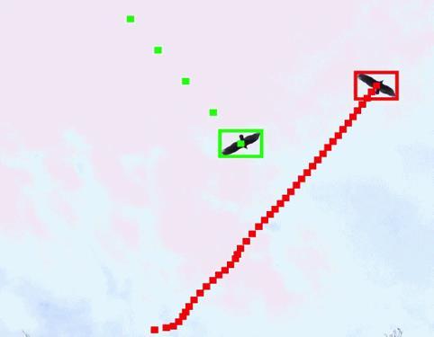
10 SOAR METHOD Fine-Grain Object Recognition Motion Detection Eliminate Background Suppress Clouds, Wind Turbines, and Insects Target Extraction Detect Bird Blobs Extract Aligned Birds Species Recognition Novel Feature Extraction Methods Novel Machine Learning Algorithms for Recognition Post-Processing Calculate Altitude, Velocity, and Trajectory Export Human Auditable Dataset December 1,

11 SPECIES RECOGNITION RESULTS Preliminary Bald Eagle Model Results December 1,
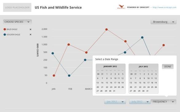
12 RAPTOR BEHAVIOR PREDICTION A Systems Approach Incorporates Meteorological Data and Species Data Predictive Classification Based on Support Vector Machines Current Model Based on Migration Data Training Data Obtained Through Partnerships US Fish & Wildlife Service Holiday Beach Bird Observatory Hawk Migration Association of North America Hawk Mountain Sanctuary Future Model Based on Field Collected Data December 1,
13 MIGRATION FORECAST Sharp-shinned Hawk (Accipiter striatus) Accipiter Example Raw Data Shown Data Is Binned for Interpretation Based on Population Thresholds Yields More Accurate Forecasts December 1,
14 MIGRATION FORECAST Red-tailed Hawk (Buteo jamaicensis) Buteo Example December 1,
15 FORECASTING IMPLICATIONS A Foundational Model Outperforms Commonly Accepted Models (e.g. Hussell & Farmer; Bird Studies Canada) for Modeling Raptor Migration Currently Trained for Migrating Raptors Given Sufficient Data, Could Be Trained for Other Species Given Sufficient Data, Could Account for Behaviors Adapting Model to Micro-Forecasting Within Regions and Sites December 1,
16 CURRENT RESEARCH Multiple Experiments One System Fully Operational Research Platform at the ALTA Wind Energy Center Multispectral Recognition Recognition Algorithms Development Visible, Near Infrared, and Thermal Long-Range Detection Ultra High Resolution Recognition Advanced Background Modeling and Target Differentiation Sensor Integration On-site Meteorological Data Collection Concurrent Acoustic Data Collection Site Modeling Incorporates Data from All Sensors Models Wildlife Use Patterns Geospatially and Temporally December 1,
17 LONG-TERM IMPLICATIONS Actionable Data from Software Wind Project Siting Automated Avian Point Counts Risk Modeling Based on Site Parameters Threat Detection Species Specific Threat Classification Automated and Auditable Reduced Curtailment Costs Species Data for Decision-Making Forecast Curtailment for Birds and Bats in Advance December 1,

18 PARTNERS AND SUPPORT Funding Partner Research Partner Expertise and Technology Partners Contributors December 1,
Working with others to conserve, protect, and enhance fish, wildlife, plants, and their habitats for the continuing benefit of the American people.
 Working with others to conserve, protect, and enhance fish, wildlife, plants, and their habitats for the continuing benefit of the American people. www.kiwifoto.com Ecological Services National Wildlife
Hawk Migration Studies by Southeastern Michigan Raptor Research at the Detroit River Mouth: A Basic Look
 Hawk Migration Studies by Southeastern Michigan Raptor Research at the Detroit River Mouth: A Basic Look Paul Cypher Southeastern Michigan Raptor Research 1983: Started as a volunteerstaffed hawkwatch
Chokecherry and Sierra Madre Wind Energy Project
 Chokecherry and Sierra Madre Wind Energy Project Intensive Avian Protection Planning Avian Protection Summary In 2010, PCW initiated a collaborative process with BLM, USFWS, and Wyoming Game and Fish Department
Eagle Observation Surveys Arkwright Summit Wind Project Chautauqua County, New York
 Eagle Observation Surveys Arkwright Summit Wind Project Chautauqua County, New York Final Report May August 2013 Prepared for: EDP Renewables 52 James Street 4 th Floor Albany, New York 12207 Prepared
New and Emerging Technologies
 New and Emerging Technologies Edwin E. Herricks University of Illinois Center of Excellence for Airport Technology (CEAT) Airport Safety Management Program (ASMP) Reality Check! There are no new basic
Greenlaw Mountain Hawk Watch Fall 2014
 Greenlaw Mountain Hawk Watch Fall 2014 Another season has come to an end. Much was learned, volunteer participation remained strong and several rarities were recorded including two new raptor species.
Greenlaw Mountain Hawk Watch Fall 2012
 Greenlaw Mountain Hawk Watch Fall 2012 Our fourth season of data collection has been completed. There were numerous exciting moments and our season total was the second highest on record. Single-day high
Work Plan for Pre-Construction Avian and Bat Surveys
 Work Plan for Pre-Construction Avian and Bat Surveys, Steuben County, New York Prepared For: EverPower Wind Holdings, Inc. 1251 Waterfront Place, 3rd Floor Pittsburgh, PA 15222 Prepared By: Stantec Consulting
Targeting a Safer World
 Targeting a Safer World INTRODUCTION Accipiter Radar is a global provider of high performance radar surveillance solutions built upon its patented Radar Intelligence Network (RIN) Platform Technology.
Automation at Depth: Ocean Infinity and seabed mapping using multiple AUVs
 Automation at Depth: Ocean Infinity and seabed mapping using multiple AUVs Ocean Infinity s seabed mapping campaign commenced in the summer of 2017. The Ocean Infinity team is made up of individuals from
WindWise Education. 2 nd. T ransforming the Energy of Wind into Powerful Minds. editi. A Curriculum for Grades 6 12
 WindWise Education T ransforming the Energy of Wind into Powerful Minds A Curriculum for Grades 6 12 Notice Except for educational use by an individual teacher in a classroom setting this work may not
Holcim Biodiversity Management System & HCA Mississauga Case Study
 Holcim Biodiversity Management System & HCA Mississauga Case Study CVC Lake Ontario Integrated Shoreline Strategy Corporate Workshop John Bayliss Manager, Environmental Approvals & Policy November 29 2011
United States Department of the Interior
 United States Department of the Interior FISH AND WILDLIFE SERVICE New England Field Office 70 Commercial Street, Suite 300 Concord, Nil 03301-5087 http://www.fws. gov/newengland Environmental Division
What is a Bird of Prey?
 2 Topic What is a Bird of Prey? beak talons Birds of prey are predators. Like all predators, they hunt and kill other animals for food. Birds of prey have specific adaptations to help them hunt, capture,
South Atlantic Bight Synoptic Offshore Observational Network
 South Atlantic Bight Synoptic Offshore Observational Network Charlie Barans Marine Resources Division South Carolina Department of Natural Resources P.O. Box 12559 Charleston, SC 29422 phone: (843) 762-5084
Polaris Sensor Technologies, Inc. SMALLEST THERMAL POLARIMETER
 Polaris Sensor Technologies, Inc. SMALLEST THERMAL POLARIMETER Pyxis LWIR 640 Industry s smallest polarization enhanced thermal imager Up to 400% greater detail and contrast than standard thermal Real-time
Polaris Sensor Technologies, Inc. Visible - Limited Detection Thermal - No Detection Polarization - Robust Detection etherm - Ultimate Detection
 Polaris Sensor Technologies, Inc. DETECTION OF OIL AND DIESEL ON WATER Visible - Limited Detection - No Detection - Robust Detection etherm - Ultimate Detection Pyxis Features: Day or night real-time sensing
Memorandum. To: Heritage Wind, LLC. From: Justin Zoladz. Date: October 30, Re: 2017 Spring Migratory Raptor Survey Results
 To: From: Justin Zoladz Date: Re: 2017 Spring Migratory Raptor Survey Results 1 Project Description (Heritage) is developing the Heritage Wind Project (Project) in the town of Barre, Orleans County, New
Engineering Solutions
 Engineering Solutions Through the SBIR program, SkySight Technologies: Has completed numerous Phase I SBIR feasibility studies Is currently focused on multiple unique Phase II SBIR programs Has successfully
Work Plan for 2015 Pre- Construction Avian and Bat Surveys Swanton Wind Project
 Work Plan for 2015 Pre- Construction Avian and Bat Surveys Swanton Wind Project Swanton Wind Project Swanton, Vermont Prepared for: Vermont Environmental Research Associates 1209 Harvey Farm Road Waterbury
Subject: Comments on FWS R5 ES , Environmental Impact Statement for Beech Ridge Energy s Habitat Conservation Plan
 October 23, 2012 Public Comments Processing Attn: FWS R5 ES 2012 0059 Division of Policy and Directives Management U.S. Fish and Wildlife Service 4401 N. Fairfax Drive, MS2042 PDM Arlington, VA 22203.
CLASSIFICATION OF VEGETATION AREA FROM SATELLITE IMAGES USING IMAGE PROCESSING TECHNIQUES ABSTRACT
 CLASSIFICATION OF VEGETATION AREA FROM SATELLITE IMAGES USING IMAGE PROCESSING TECHNIQUES Arpita Pandya Research Scholar, Computer Science, Rai University, Ahmedabad Dr. Priya R. Swaminarayan Professor
Adaptation and Application of Aerospace and Defense Industry Technologies to the Oil and Gas Industry
 ELTA Systems Group & Subsidiary of ISRAEL AEROSPACE INDUSTRIES Adaptation and Application of Aerospace and Defense Industry Technologies to the Oil and Gas Industry Dr. Nathan Weiss Israel Aerospace Industries
Joint Industry Program: Development of Improved Ice Management Capabilities for Operations in Arctic and Harsh Environments.
 Joint Industry Program: Development of Improved Ice Management Capabilities for Operations in Arctic and Harsh Environments November 2014 This page is intentionally blank. 2 Introduction Petroleum Research
Riser Lifecycle Monitoring System for Integrity Management
 Riser Lifecycle Monitoring System for Integrity Management 11121-5402-01 Judith Guzzo GE Global Research RPSEA Ultra-Deepwater Technology Conference October 29-30, 2013 Lone Star College Conference Center
Realtime Airborne Imagery for Emergency GIS Applications
 Realtime Airborne Imagery for Emergency GIS Applications Demonstration and Evaluation with Monroe County Office of Emergency Management August - September 2010 Information Products Laboratory for Emergency
Exploring Pedestrian Bluetooth and WiFi Detection at Public Transportation Terminals
 Exploring Pedestrian Bluetooth and WiFi Detection at Public Transportation Terminals Neveen Shlayan 1, Abdullah Kurkcu 2, and Kaan Ozbay 3 November 1, 2016 1 Assistant Professor, Department of Electrical
The following protocols should begin as soon as feasible after identification of a diurnal roost (ideally that night):
:") PERSONNEL Qualified biologists 48, biological technicians, and any other individuals deemed qualified by a local USFWS FO may conduct emergence surveys for Indiana bats by following the protocols below.
PERSONNEL Qualified biologists 48, biological technicians, and any other individuals deemed qualified by a local USFWS FO may conduct emergence surveys for Indiana bats by following the protocols below.
UNCLASSIFIED. InnoVision Overview. Theron Anders 16 April 2008 Precision Strike Annual Programs Review UNCLASSIFIED
 InnoVision Overview Theron Anders 16 April 2008 Precision Strike Annual Programs Review 1 Functional Manager for NSG RDT&E InnoVision is the Functional Manager for the National System for Geospatial Intelligence
Targeting a Safer World. Public Safety & Security
 Targeting a Safer World Public Safety & Security WORLD S MOST EFFECTIVE AND AFFORDABLE WIDE-AREA SITUATIONAL AWARENESS Accipiter provides the world s most effective and affordable wide-area situational
Bird Monitoring & Reduction of Collision Risk with Wind Turbines DTBIRD SYSTEM
 Bird Monitoring & Reduction of Collision Risk with Wind Turbines DTBIRD SYSTEM SEPTEMBER 2017 Introduction Bird Monitoring & Reduction of Collision Risk with Wind Turbines DTBird is a self-working system
Wide-area Motion Imagery for Multi-INT Situational Awareness
 Wide-area Motion Imagery for Multi-INT Situational Awareness Bernard V. Brower Jason Baker Brian Wenink Harris Corporation TABLE OF CONTENTS ABSTRACT... 3 INTRODUCTION WAMI HISTORY... 4 WAMI Capabilities
Greenlaw Mountain Hawk Watch Fall 2011
 Greenlaw Mountain Hawk Watch Fall 2011 Our third season of fall counts has been completed and it was an exciting year. We recorded 15 species of raptor, and had high season counts for several species and
Intelligent Sensor Platforms for Remotely Piloted and Unmanned Vehicles. Dr. Nick Krouglicof 14 June 2012
 Intelligent Sensor Platforms for Remotely Piloted and Unmanned Vehicles Dr. Nick Krouglicof 14 June 2012 Project Overview Project Duration September 1, 2010 to June 30, 2016 Primary objective(s) / outcomes
Environment and Natural Resources Trust Fund 2019 Request for Proposals (RFP)
") Environment and Natural Resources Trust Fund 2019 Request for Proposals (RFP) Project Title: Mercury and PFAS Risk to Minnesota Raptors Category: A. Foundational Natural Resource Data and Information ENRTF
Environment and Natural Resources Trust Fund 2019 Request for Proposals (RFP) Project Title: Mercury and PFAS Risk to Minnesota Raptors Category: A. Foundational Natural Resource Data and Information ENRTF
DISTRIBUTION STATEMENT A. Approved for public release; distribution is unlimited.
 DISTRIBUTION STATEMENT A. Approved for public release; distribution is unlimited. Glider-based Passive Acoustic Monitoring Techniques in the Southern California Region & West Coast Naval Training Range
Using Zena Prototypes as Perching Deterrents on Airfield Signage
 University of Nebraska - Lincoln DigitalCommons@University of Nebraska - Lincoln 2007 Bird Strike Committee USA/Canada, 9th Annual Meeting, Kingston, Ontario Bird Strike Committee Proceedings September
Project Number: H Project Title:
 Project Number: 3-H Project Title: PWS Herring Survey: Seasonal and Interannual Trends in Seabird Predation on Juvenile Herring PI Name: Dr. Mary Anne Bishop and Dr. Kathy Kuletz Time period covered: FY
ACOUSTIC RESEARCH FOR PORT PROTECTION AT THE STEVENS MARITIME SECURITY LABORATORY
 ACOUSTIC RESEARCH FOR PORT PROTECTION AT THE STEVENS MARITIME SECURITY LABORATORY Alexander Sutin, Barry Bunin Stevens Institute of Technology, Castle Point on Hudson, Hoboken, NJ 07030, United States
Salem County Raptor Census
 Jack Mahon The Salem County Raptor Census provides a continuous record of observed wintering raptors in Salem County, New Jersey, for the years 1989 through 2009. The year 1979 marked the second annual
products PC Control
 products PC Control 04 2017 PC Control 04 2017 products Image processing directly in the PLC TwinCAT Vision Machine vision easily integrated into automation technology Automatic detection, traceability
Virtual Grasping Using a Data Glove
 Virtual Grasping Using a Data Glove By: Rachel Smith Supervised By: Dr. Kay Robbins 3/25/2005 University of Texas at San Antonio Motivation Navigation in 3D worlds is awkward using traditional mouse Direct
Machine Learning and Decision Making for Sustainability
 Machine Learning and Decision Making for Sustainability Stefano Ermon Department of Computer Science Stanford University April 12 Overview Stanford Artificial Intelligence Lab Fellow, Woods Institute for
DTBird System Specifications for Wind Turbines
 DTBird System Specifications for Wind Turbines Day & Night On & Offshore DTBIRD TEAM November 2017. Ref.: DTB0516SPWTG.Rev2 Fulfilled: Marcos Puente 13/11/17 Reviewed: Javier Díaz 14/11/17 Approved: Agustín
Module 3 Introduction to GIS. Lecture 8 GIS data acquisition
 Module 3 Introduction to GIS Lecture 8 GIS data acquisition GIS workflow Data acquisition (geospatial data input) GPS Remote sensing (satellites, UAV s) LiDAR Digitized maps Attribute Data Management Data
Detection and Monitoring Through Remote Sensing....The Need For A New Remote Sensing Platform
 WILDFIRES Detection and Monitoring Through Remote Sensing...The Need For A New Remote Sensing Platform Peter Kimball ASEN 5235 Atmospheric Remote Sensing 5/1/03 1. Abstract This paper investigates the
Development of Mid-Frequency Multibeam Sonar for Fisheries Applications
 Development of Mid-Frequency Multibeam Sonar for Fisheries Applications John K. Horne University of Washington, School of Aquatic and Fishery Sciences Box 355020 Seattle, WA 98195 phone: (206) 221-6890
Our position. ICDPPC declaration on ethics and data protection in artificial intelligence
 ICDPPC declaration on ethics and data protection in artificial intelligence AmCham EU speaks for American companies committed to Europe on trade, investment and competitiveness issues. It aims to ensure
SATELLITE OCEANOGRAPHY
 SATELLITE OCEANOGRAPHY An Introduction for Oceanographers and Remote-sensing Scientists I. S. Robinson Lecturer in Physical Oceanography Department of Oceanography University of Southampton JOHN WILEY
Avian Project Guidance
 SPECIES MANAGEMENT Avian Project Guidance Stakeholder Informed Introduction Avian species, commonly known as birds, are found on every continent and play important roles in the world s ecosystems and cultures.
Detection and Identification of Remotely Piloted Aircraft Systems Using Weather Radar
 Microwave Remote Sensing Laboratory Detection and Identification of Remotely Piloted Aircraft Systems Using Weather Radar Krzysztof Orzel1 Siddhartan Govindasamy2, Andrew Bennett2 David Pepyne1 and Stephen
Reliability of Counts of Migrating Raptors: an Experimental Analysis
 Liberty University DigitalCommons@Liberty University Faculty Publications and Presentations Department of Biology and Chemistry Fall 1984 Reliability of Counts of Migrating Raptors: an Experimental Analysis
AUTUMN HAWK MIGRATIONS AT FORT JOHNSON, CHARLESTON, S.C.
 AUTUMN HAWK MIGRATIONS AT FORT JOHNSON, CHARLESTON, S.C. PETE LAURIE, JOHN W. McCORD, and NAN C. JENKINS The fall migration of raptors on the East Coast of North America is well documented from New England
Long-billed Curlew Surveys in the Mission Valley, 2015
 Long-billed Curlew Surveys in the Mission Valley, 2015 Janene Lichtenberg lead a field trips in the Mission Valley, talking about Curlews, and volunteers scoured the valley for along 25 driving routes
High Performance Infrared Imaging Systems. Cedip Presentation
 High Performance Infrared Imaging Systems > Mission Statement A Pure Player of the Infrared Imaging Industry Since 1989, Cedip Infrared Systems has provided world class infrared imaging cameras and systems
SECOND OPEN SKIES REVIEW CONFERENCE (OSRC) 2010
 2010") OSCC.RC/40/10 9 June 2010 Open Skies Consultative Commission ENGLISH only US Chair of the OSCC Review Conference SECOND OPEN SKIES REVIEW CONFERENCE (OSRC) 2010 7 to 9 June 2010 Working Session 2 Exploring
OSCC.RC/40/10 9 June 2010 Open Skies Consultative Commission ENGLISH only US Chair of the OSCC Review Conference SECOND OPEN SKIES REVIEW CONFERENCE (OSRC) 2010 7 to 9 June 2010 Working Session 2 Exploring
Capture the invisible
 Capture the invisible A Capture the invisible The Sequoia multispectral sensor captures both visible and invisible images, providing calibrated data to optimally monitor the health and vigor of your crops.
Joint Industry Programme on E&P Sound and Marine Life - Phase III
 Joint Industry Programme on E&P Sound and Marine Life - Phase III Request for Proposals Number: JIP III-15-03 Long Term Fixed Acoustic Monitoring of Marine Mammals throughout the Life Cycle of an Offshore
Appendix G. Avian and Bat Work Plans
 Appendix G Avian and Bat Work Plans North Ridge Wind Project Avian Survey Work Plan St. Lawrence County, New York Prepared for: Iberdrola Renewables, LLC Two Radnor Corporate Center Suite 200 100 Matsonford
Briefing NMFS proposal to revise regulations concerning the use and approval of scales for weighing catch at-sea.
 Briefing NMFS proposal to revise regulations concerning the use and approval of scales for weighing catch at-sea. OVERVIEW The use of at-sea scales can provide very precise and potentially accurate estimates
GPS System Design and Control Modeling. Chua Shyan Jin, Ronald. Assoc. Prof Gerard Leng. Aeronautical Engineering Group, NUS
 GPS System Design and Control Modeling Chua Shyan Jin, Ronald Assoc. Prof Gerard Leng Aeronautical Engineering Group, NUS Abstract A GPS system for the autonomous navigation and surveillance of an airship
DISCRIMINANT FUNCTION CHANGE IN ERDAS IMAGINE
 DISCRIMINANT FUNCTION CHANGE IN ERDAS IMAGINE White Paper April 20, 2015 Discriminant Function Change in ERDAS IMAGINE For ERDAS IMAGINE, Hexagon Geospatial has developed a new algorithm for change detection
EVALUATING FEATURES FOR BROAD SPECIES BASED CLASSIFICATION OF BIRD OBSERVATIONS USING DUAL-POLARIZED DOPPLER WEATHER RADAR
 University of Massachusetts Amherst ScholarWorks@UMass Amherst Masters Theses Dissertations and Theses 2016 EVALUATING FEATURES FOR BROAD SPECIES BASED CLASSIFICATION OF BIRD OBSERVATIONS USING DUAL-POLARIZED
Pragmatic Strategies for Adopting Model-Based Design for Embedded Applications. The MathWorks, Inc.
 Pragmatic Strategies for Adopting Model-Based Design for Embedded Applications Larry E. Kendrick, PhD The MathWorks, Inc. Senior Principle Technical Consultant Introduction What s MBD? Why do it? Make
Crop Scouting with Drones Identifying Crop Variability with UAVs
 DroneDeploy Crop Scouting with Drones Identifying Crop Variability with UAVs A Guide to Evaluating Plant Health and Detecting Crop Stress with Drone Data Table of Contents 01 Introduction Crop Scouting
A Study on Retrieval Algorithm of Black Water Aggregation in Taihu Lake Based on HJ-1 Satellite Images
 IOP Conference Series: Earth and Environmental Science OPEN ACCESS A Study on Retrieval Algorithm of Black Water Aggregation in Taihu Lake Based on HJ-1 Satellite Images To cite this article: Zou Lei et
CATALOGUE. HBRP Publication
 CATALOGUE HBRP Publication ARCHITECTURE Journal of Housing and Advancement in Interior Designing Є Housing Science and Management Є Computer Techniques in Architectural Design Є Construction Industry and
MULTISPECTRAL AGRICULTURAL ASSESSMENT. Normalized Difference Vegetation Index. Federal Robotics INSPECTION & DOCUMENTATION
 MULTISPECTRAL AGRICULTURAL ASSESSMENT Normalized Difference Vegetation Index INSPECTION & DOCUMENTATION Federal Robotics Clearwater Dr. Amherst, New York 14228 716-221-4181 Sales@FedRobot.com www.fedrobot.com
Distributed Robotics From Science to Systems
 Distributed Robotics From Science to Systems Nikolaus Correll Distributed Robotics Laboratory, CSAIL, MIT August 8, 2008 Distributed Robotic Systems DRS 1 sensor 1 actuator... 1 device Applications Giant,
Manufacturing Systems Engineering Key Expertise Theme. astutewales.com
 Manufacturing Systems Engineering Key Expertise Theme astutewales.com Exploit Resources & Connectivity in the Manufacturing Process Improve quality, productivity and sustainability. The Whole Life Cycle
Sea Duck Joint Venture Annual Project Summary for Endorsed Projects FY 2010 (October 1, 2009 to Sept 30, 2010)
") Sea Duck Joint Venture Annual Project Summary for Endorsed Projects FY 2010 (October 1, 2009 to Sept 30, 2010) Project Title: No. 2 Identification of Chukchi and Beaufort Sea Migration Corridor for Sea
Sea Duck Joint Venture Annual Project Summary for Endorsed Projects FY 2010 (October 1, 2009 to Sept 30, 2010) Project Title: No. 2 Identification of Chukchi and Beaufort Sea Migration Corridor for Sea
Long-billed Curlew Surveys in the Mission Valley, 2017
 Long-billed Curlew Surveys in the Mission Valley, 2017 This year, 20 volunteers scoured the Mission Valley along 22 driving routes to locate North America s largest shorebird (curlew by Raylene Wall above
Daniel A. Bachen - Curriculum Vitae
 Daniel A. Bachen - Curriculum Vitae Montana Natural Program, 1515 East Sixth Avenue, Helena, Montana, 59620-1800 Work Phone: (406) 444-3586 Cell Phone: (406) 546-4302 dbachen@mt.gov Goal: To pursue a career
The Western Section of The Wildlife Society and Wildlife Research Institute Western Raptor Symposium February 8-9, 2011 Riverside, California
 The Western Section of The Wildlife Society and Wildlife Research Institute Western Raptor Symposium February 8-9, 2011 Riverside, California Symposium Sponsors February 8 03:55-04:10 pm Session: Department
DRAFT Mad River Wind Project Avian and Bat Survey Work Plan:
 DRAFT Mad River Wind Project Avian and Bat Survey Work Plan: 2016-2017 Jefferson and Oswego Counties, New York Prepared for: Avangrid Renewables, LLC Two Radnor Corporate Center Suite 200 100 Matsonford
Optimizing throughput with Machine Vision Lighting. Whitepaper
 Optimizing throughput with Machine Vision Lighting Whitepaper Optimizing throughput with Machine Vision Lighting Within machine vision systems, inappropriate or poor quality lighting can often result in
Discussion of California Condors and Habitat Conservation Planning in the Tehachapi Wind Resource Area. Friday - April 7, 2017 Mojave, CA
 Discussion of California Condors and Habitat Conservation Planning in the Tehachapi Wind Resource Area Friday - April 7, 2017 Mojave, CA Meeting agenda Introductions Presentation by USFWS: setting the
2016 Smart Cities Survey Summary Report of Survey Results
 Introduction 2016 Smart Cities Survey Summary Report of Survey Results In 2016, the International City/County Management Association (ICMA) conducted a survey in partnership with the Smart Cities Council
Mining Industry Engagement Workshop
 Mining Industry Engagement Workshop Summary Report December 14, 2017 i Executive Summary The National Research Council of Canada (NRC), in collaboration with the Natural Sciences and Engineering Research
Bird Monitoring & Reduction of Collision Risk with Wind Turbines DTBIRD SYSTEM
 Bird Monitoring & Reduction of Collision Risk with Wind Turbines DTBIRD SYSTEM MAY 2017 Introduction Bird Monitoring & Reduction of Collision Risk with Wind Turbines DTBird is a self-working system that
ROBOT VISION. Dr.M.Madhavi, MED, MVSREC
 ROBOT VISION Dr.M.Madhavi, MED, MVSREC Robotic vision may be defined as the process of acquiring and extracting information from images of 3-D world. Robotic vision is primarily targeted at manipulation
S&T Stakeholders Conference
 S&T Stakeholders Conference May 21-24, 2007 Future Attribute Screening Technology Mobile Module (FAST M 2 ) Innovation/HSARPA HIP Bob Burns Program Manager Office of Innovation/Human Factors Division Science
Govt. Engineering College Jhalawar Model Question Paper Subject- Remote Sensing & GIS
 Govt. Engineering College Jhalawar Model Question Paper Subject- Remote Sensing & GIS Time: Max. Marks: Q1. What is remote Sensing? Explain the basic components of a Remote Sensing system. Q2. What is
Study Surveys of Eagles and Other Raptors
 Initial Study Report Meeting Study 10.14 Surveys of Eagles and Other Raptors March 29, 2016 Prepared by ABR, Inc. Environmental Research & Services 3/29/2016 1 Study 10.14 Status ISR Documents (ISR Part
New Challenges for Research in Tuning. Clifford Adelman Tuning Academy Launch 15 June, 2011
 New Challenges for Research in Tuning Clifford Adelman Tuning Academy Launch 15 June, 2011 What does research on Tuning mean? Determination of the critical mass of faculty participation. Analysis of assessments
Autonomous Mobile Robot Design. Dr. Kostas Alexis (CSE)
") Autonomous Mobile Robot Design Dr. Kostas Alexis (CSE) Course Goals To introduce students into the holistic design of autonomous robots - from the mechatronic design to sensors and intelligence. Develop
Autonomous Mobile Robot Design Dr. Kostas Alexis (CSE) Course Goals To introduce students into the holistic design of autonomous robots - from the mechatronic design to sensors and intelligence. Develop
ICT4 Manuf. Competence Center
 ICT4 Manuf. Competence Center Prof. Yacine Ouzrout University Lumiere Lyon 2 ICT 4 Manufacturing Competence Center AI and CPS for Manufacturing Robot software testing Development of software technologies
Deriving meteorological observations from intercepted Mode-S EHS messages.
 Deriving meteorological observations from intercepted Mode-S EHS messages. Edmund Keith Stone and Malcolm Kitchen July 28, 2016 Abstract The Met Office has deployed a network of five receivers in the UK
Bats in Alaska: Citizen Science and Field Research Give New Insights about their Distribution, Ecology, and Overwintering Behavior
 Bats in Alaska: Citizen Science and Field Research Give New Insights about their Distribution, Ecology, and Overwintering Behavior Project PIs: David Tessler and Marian Snively Presenter: Veronica Padula
An Acoustic / Radar System for Automated Detection, Localization, and Classification of Birds in the Vicinity of Airfields
 An Acoustic / Radar System for Automated Detection, Localization, and Classification of Birds in the Vicinity of Airfields Dr. Sebastian M. Pascarelle & Dr. Bruce Stewart (AAC) T. Adam Kelly & Andreas
Impact of wind farms on birds and bats
 Impact of wind farms on birds and bats Dr. Hermann Hötker Michael-Otto-Institut im NABU BirdLife Partner Germany Methods Disturbance and Displacement Collision mortality Repowering download: http://bergenhusen.nabu.de/bericht/voegelregenergien.pdf
Supervisors: Rachel Cardell-Oliver Adrian Keating. Program: Bachelor of Computer Science (Honours) Program Dates: Semester 2, 2014 Semester 1, 2015
 Program Dates: Semester 2, 2014 Semester 1, 2015") Supervisors: Rachel Cardell-Oliver Adrian Keating Program: Bachelor of Computer Science (Honours) Program Dates: Semester 2, 2014 Semester 1, 2015 Background Aging population [ABS2012, CCE09] Need to
Supervisors: Rachel Cardell-Oliver Adrian Keating Program: Bachelor of Computer Science (Honours) Program Dates: Semester 2, 2014 Semester 1, 2015 Background Aging population [ABS2012, CCE09] Need to
Responsive AUV Localization and Mapping Project. Ron Lewis, Project Manager June 14 th, 2012
 Responsive AUV Localization and Mapping Project Ron Lewis, Project Manager June 14 th, 2012 Project Overview Project duration: Approximately 5 Years June 1, 2010 to March 31, 2015 Primary objectives: Develop
Development of the sacker Falcon (Falco Cher rug) Global Action Plan (sacker GAP)
 Global Action Plan (sacker GAP)") Development of the sacker Falcon (Falco Cher rug) Global Action Plan (sacker GAP) Sacker GAP Questionnaire: To be compiled and submitted by National Information Coordinators from each Range State of the
Development of the sacker Falcon (Falco Cher rug) Global Action Plan (sacker GAP) Sacker GAP Questionnaire: To be compiled and submitted by National Information Coordinators from each Range State of the
Preliminary Design Phase Activities, Priorities and Opportunities
 Preliminary Design Phase Activities, Priorities and Opportunities Massively multiplexed spectroscopy with MSE: Science, Project and Vision Kei Szeto MSE Project Office 28 February, 2019 Outline Overview
Improving Signal- to- noise Ratio in Remotely Sensed Imagery Using an Invertible Blur Technique
 Improving Signal- to- noise Ratio in Remotely Sensed Imagery Using an Invertible Blur Technique Linda K. Le a and Carl Salvaggio a a Rochester Institute of Technology, Center for Imaging Science, Digital
Some Relationships Between Fall Hawk Migration and Weather Features at High Park, Toronto
 78 Some Relationships Between Fall Hawk Migration and Weather Features at High Park, Toronto Donald W. Barnett The annual fall migration of diurnal raptors over High Park, Toronto, Ontario has been monitored
Smarter oil and gas exploration with IBM
 IBM Sales and Distribution Oil and Gas Smarter oil and gas exploration with IBM 2 Smarter oil and gas exploration with IBM IBM can offer a combination of hardware, software, consulting and research services
Chapter 2 : Aerial Survey Methods
 Chapter 2 : Aerial Survey Methods Emily E. Connelly, Melissa Duron, Iain J. Stenhouse, Kathryn A. Williams Introduction High-definition video aerial surveys were conducted by (BRI) and HiDef Aerial Surveying,
Development and Integration of Artificial Intelligence Technologies for Innovation Acceleration
 Development and Integration of Artificial Intelligence Technologies for Innovation Acceleration Research Supervisor: Minoru Etoh (Professor, Open and Transdisciplinary Research Initiatives, Osaka University)